CN108632739B - Signaling data-based positioning method and device - Google Patents
Signaling data-based positioning method and deviceDownload PDFInfo
- Publication number
- CN108632739B CN108632739BCN201710168116.XACN201710168116ACN108632739BCN 108632739 BCN108632739 BCN 108632739BCN 201710168116 ACN201710168116 ACN 201710168116ACN 108632739 BCN108632739 BCN 108632739B
- Authority
- CN
- China
- Prior art keywords
- mobile terminal
- latitude
- distance
- longitude
- base station
- Prior art date
- Legal status (The legal status is an assumption and is not a legal conclusion. Google has not performed a legal analysis and makes no representation as to the accuracy of the status listed.)
- Active
Links
Images


Classifications
- H—ELECTRICITY
- H04—ELECTRIC COMMUNICATION TECHNIQUE
- H04W—WIRELESS COMMUNICATION NETWORKS
- H04W4/00—Services specially adapted for wireless communication networks; Facilities therefor
- H04W4/02—Services making use of location information
- H04W4/025—Services making use of location information using location based information parameters
- H04W4/026—Services making use of location information using location based information parameters using orientation information, e.g. compass
- H—ELECTRICITY
- H04—ELECTRIC COMMUNICATION TECHNIQUE
- H04W—WIRELESS COMMUNICATION NETWORKS
- H04W64/00—Locating users or terminals or network equipment for network management purposes, e.g. mobility management
- H04W64/006—Locating users or terminals or network equipment for network management purposes, e.g. mobility management with additional information processing, e.g. for direction or speed determination
Landscapes
- Engineering & Computer Science (AREA)
- Computer Networks & Wireless Communication (AREA)
- Signal Processing (AREA)
- Mobile Radio Communication Systems (AREA)
- Position Fixing By Use Of Radio Waves (AREA)
- Navigation (AREA)
Abstract
Translated fromChinese
Description
Translated fromChinese技术领域technical field
本发明涉及无线通信技术领域,尤其涉及一种基于信令数据的定位方法和装置。The present invention relates to the technical field of wireless communication, and in particular, to a positioning method and device based on signaling data.
背景技术Background technique
随着通信技术的快速发展,移动通信服务的范围越来越广。为了更好的提供高质量的移动通信服务,需要获得用户的移动终端(例如智能手机)的信令数据,通过对这些信令数据处理分析来获得用户所处地区的通信质量情况,从而做出快速并且有针对性的处理。With the rapid development of communication technology, the scope of mobile communication services is becoming wider and wider. In order to better provide high-quality mobile communication services, it is necessary to obtain the signaling data of the user's mobile terminal (such as a smart phone). Fast and targeted processing.
申请人经研究发现:在传统的软采信令分析中,通过软采得到的字段中只有ID(identification,身份标识号)作为用户的唯一识别方式,而无法使用用户的手机号作为每一个用户的识别标志。具体来说,由于用户的ID在掉线后会被重新分配,因此无法直接利用软采字段中的ID准确追踪定位用户。只能通过软采数据进行小区级别的粗定位,并在粗定位的基础上进行用户通话体验分析,而无法对数据进行用户级的精确分析处理。The applicant found through research that: in the traditional soft-sampling signaling analysis, only the ID (identification, identification number) is used as the only way to identify the user in the fields obtained through the soft-sampling, and the user's mobile phone number cannot be used as each user's mobile phone number. identification mark. Specifically, since the user's ID will be reassigned after disconnection, it is impossible to directly use the ID in the soft-acquisition field to accurately track and locate the user. It is only possible to perform rough positioning at the cell level through soft-collected data, and analyze the user's call experience based on the rough positioning, but cannot perform precise user-level analysis and processing of the data.
如何通过软采的信令数据对用户进行精确位置定位成为业界亟待解决的问题。How to accurately locate the user through the soft-collected signaling data has become an urgent problem to be solved in the industry.
发明内容SUMMARY OF THE INVENTION
为了解决通过软采的信令数据对用户定位的精度较低的问题,本发明实施例提供了一种基于信令数据的定位方法和装置。In order to solve the problem of low accuracy of user positioning through soft-collected signaling data, embodiments of the present invention provide a signaling data-based positioning method and device.
第一方面,提供了一种基于信令数据的定位方法。该方法包括以下步骤:In a first aspect, a positioning method based on signaling data is provided. The method includes the following steps:
利用基站对移动终端的信令软采,得到到达角度AOA的字段和时间提前量TA的字段;Utilize the soft acquisition of the signaling of the mobile terminal by the base station to obtain the field of the angle of arrival AOA and the field of the time advance TA;
根据AOA的字段和TA的字段,计算出移动终端相对基站的到达角和距离;According to the field of AOA and the field of TA, calculate the arrival angle and distance of the mobile terminal relative to the base station;
基于到达角和距离,计算出移动终端相对基站的在经度方向上的经度距离和在纬度方向上的纬度距离;Based on the angle of arrival and the distance, the longitude distance in the longitude direction and the latitude distance in the latitude direction of the mobile terminal relative to the base station are calculated;
依据经度距离和纬度距离,计算得到移动终端所在位置的经度和纬度;Calculate the longitude and latitude of the location of the mobile terminal according to the longitude distance and the latitude distance;
基于道路网对道路网对应的地图进行分区,生成移动终端的合理运动区域;Divide the map corresponding to the road network based on the road network to generate a reasonable movement area of the mobile terminal;
根据经度和纬度将移动终端所在位置标记在地图上,删除合理运动区域外标记的位置。Mark the location of the mobile terminal on the map according to the longitude and latitude, and delete the marked location outside the reasonable movement area.
第二方面,提供了一种基于信令数据的定位装置。该装置包括:In a second aspect, a positioning apparatus based on signaling data is provided. The device includes:
信令软采单元,利用基站对移动终端的信令软采,得到到达角度AOA的字段和时间提前量TA的字段;The signaling soft acquisition unit utilizes the signaling soft acquisition of the mobile terminal by the base station to obtain the field of the angle of arrival AOA and the field of the time advance TA;
第一计算单元,用于根据AOA的字段和TA的字段,计算出移动终端相对基站的到达角和距离;The first calculation unit is used to calculate the angle of arrival and the distance of the mobile terminal relative to the base station according to the field of the AOA and the field of the TA;
第二计算单元,用于基于到达角和距离,计算出移动终端相对基站的在经度方向上的经度距离和在纬度方向上的纬度距离;The second calculation unit is used to calculate the longitude distance in the longitude direction and the latitude distance in the latitude direction of the mobile terminal relative to the base station based on the angle of arrival and the distance;
第三计算单元,用于依据经度距离和纬度距离,计算得到移动终端所在位置的经度和纬度;The third calculation unit is used to calculate the longitude and latitude of the location of the mobile terminal according to the longitude distance and the latitude distance;
区域划分单元,用于基于道路网对道路网对应的地图进行分区,生成移动终端的合理运动区域;The area division unit is used to divide the map corresponding to the road network based on the road network to generate a reasonable movement area of the mobile terminal;
位置删除单元,用于根据经度和纬度将移动终端所在位置标记在地图上,删除合理运动区域外标记的位置。The location deletion unit is used to mark the location of the mobile terminal on the map according to the longitude and latitude, and delete the marked location outside the reasonable movement area.
本实施例可以应用于用户定位的场景,具体可以通过对用户随身携带的移动终端(例如手机)的定位来间接对用户进行定位。This embodiment may be applied to a user positioning scenario, and specifically, the user may be indirectly positioned by locating a mobile terminal (eg, a mobile phone) carried by the user.
本实施例可以通过信令软采,得到AOA字段和TA字段,然后计算出移动终端相对基站的到达角和距离,再计算出移动终端相对基站的经度距离和纬度距离,之后计算得到移动终端所在位置的经度和纬度,可以实现用户级别的精确定位,解决了现有的只能进行小区级别的定位的精度较低的问题。另外,本实施例通过对地图进行预处理,生成移动终端的合理运动区域,将移动终端所在位置标记在地图上,删除合理运动区域外标记的位置,可以进一步提高用户的定位精度。In this embodiment, the AOA field and the TA field can be obtained through soft acquisition of signaling, and then the arrival angle and distance of the mobile terminal relative to the base station are calculated, and then the longitude distance and latitude distance of the mobile terminal relative to the base station are calculated, and then the location of the mobile terminal is calculated. The longitude and latitude of the location can realize precise positioning at the user level, which solves the problem that the existing positioning can only be performed at the cell level with low precision. In addition, this embodiment generates a reasonable movement area of the mobile terminal by preprocessing the map, marks the location of the mobile terminal on the map, and deletes the marked position outside the reasonable movement area, which can further improve the user's positioning accuracy.
附图说明Description of drawings
为了更清楚地说明本发明实施例的技术方案,下面将对本发明实施例中所需要使用的附图作简单地介绍,显而易见地,下面所描述的附图仅仅是本发明的一些实施例,对于本领域普通技术人员来讲,在不付出创造性劳动的前提下,还可以根据这些附图获得其他的附图。In order to illustrate the technical solutions of the embodiments of the present invention more clearly, the following briefly introduces the accompanying drawings that need to be used in the embodiments of the present invention. Obviously, the drawings described below are only some embodiments of the present invention. For those of ordinary skill in the art, other drawings can also be obtained from these drawings without any creative effort.
图1是本发明一实施例的基于信令数据的定位方法的流程示意图。FIG. 1 is a schematic flowchart of a positioning method based on signaling data according to an embodiment of the present invention.
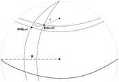
图2是本发明一实施例的终端与基站的位置关系示意图。FIG. 2 is a schematic diagram of a positional relationship between a terminal and a base station according to an embodiment of the present invention.
图3是本发明另一实施例的终端与基站的位置关系示意图。FIG. 3 is a schematic diagram of a positional relationship between a terminal and a base station according to another embodiment of the present invention.
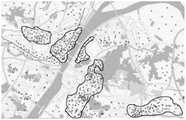
图4是本发明一实施例的根据当地的道路网进行第一次分区的示意图。FIG. 4 is a schematic diagram of the first zoning according to the local road network according to an embodiment of the present invention.
图5是本发明一实施例的根据当地的道路网进行第二次分区的示意图。FIG. 5 is a schematic diagram of the second zoning according to the local road network according to an embodiment of the present invention.
图6为本发明一实施例的基于信令数据的定位装置的功能结构示意图。FIG. 6 is a schematic diagram of a functional structure of a positioning apparatus based on signaling data according to an embodiment of the present invention.
具体实施方式Detailed ways
为使本发明实施例的目的、技术方案和优点更加清楚,下面将结合本发明实施例中的附图,对本发明实施例中的技术方案进行清楚、完整地描述,显然,所描述的实施例是本发明一部分实施例,而不是全部的实施例。基于本发明中的实施例,本领域普通技术人员在没有作出创造性劳动前提下所获得的所有其他实施例,都属于本发明保护的范围。In order to make the purposes, technical solutions and advantages of the embodiments of the present invention clearer, the technical solutions in the embodiments of the present invention will be clearly and completely described below with reference to the accompanying drawings in the embodiments of the present invention. Obviously, the described embodiments These are some embodiments of the present invention, but not all embodiments. Based on the embodiments of the present invention, all other embodiments obtained by those of ordinary skill in the art without creative efforts shall fall within the protection scope of the present invention.
需要说明的是,在不冲突的情况下,本申请中的实施例及实施例中的特征可以相互组合。下面将参考附图并结合实施例来详细说明本申请。It should be noted that the embodiments in the present application and the features of the embodiments may be combined with each other in the case of no conflict. The present application will be described in detail below with reference to the accompanying drawings and in conjunction with the embodiments.
图1是本发明一实施例的基于信令数据的定位方法的流程示意图。FIG. 1 is a schematic flowchart of a positioning method based on signaling data according to an embodiment of the present invention.
如图1所示,该方法包括以下步骤:S110,利用基站对移动终端的信令软采,得到到达角度AOA的字段和时间提前量TA的字段;S120,根据AOA的字段和TA的字段,计算出移动终端相对基站的到达角和距离;S130,基于到达角和距离,计算出移动终端相对基站的在经度方向上的经度距离和在纬度方向上的纬度距离;S140,依据经度距离和纬度距离,计算得到移动终端所在位置的经度和纬度;S150,基于道路网对道路网对应的地图进行分区,生成移动终端的合理运动区域;S160,根据经度和纬度将移动终端所在位置标记在地图上,删除合理运动区域外标记的位置。As shown in FIG. 1, the method includes the following steps: S110, use the base station to softly acquire the signaling of the mobile terminal to obtain the field of the angle of arrival AOA and the field of the time advance TA; S120, according to the field of the AOA and the field of the TA, Calculate the angle of arrival and the distance of the mobile terminal relative to the base station; S130, based on the angle of arrival and the distance, calculate the longitude distance in the longitude direction and the latitude distance in the latitude direction of the mobile terminal relative to the base station; S140, according to the longitude distance and latitude distance, calculate the longitude and latitude of the location of the mobile terminal; S150, partition the map corresponding to the road network based on the road network, and generate a reasonable movement area of the mobile terminal; S160, mark the location of the mobile terminal on the map according to the longitude and latitude , delete the marked positions outside the reasonable motion area.
在步骤S110中,利用基站对移动终端的信令软采得到AOA与TA字段。其中,AOA是测量信号的到达角度。具体的,AOA为待定位终端的入射方向与正北方向夹角。TA是时间提前量。TA指示移动台提前发送的时间。TA由基站测量后通知移动台(即终端)提前这段TA时间发送数据,目的是为了扣除基站与终端之间的传输时延。例如,移动台在信道上以489ms一次的频率向基站发送指令,那么,1个TA为4.89米。In step S110, the AOA and TA fields are obtained by soft acquisition of the signaling of the mobile terminal by the base station. where AOA is the angle of arrival of the measurement signal. Specifically, the AOA is the angle between the incident direction of the terminal to be located and the true north direction. TA is the time advance. TA indicates the time that the mobile station sends in advance. After the TA is measured by the base station, the mobile station (ie, the terminal) is notified to send data in advance of this TA time, in order to deduct the transmission delay between the base station and the terminal. For example, if the mobile station sends commands to the base station at a frequency of 489ms on the channel, then one TA is 4.89 meters.
在步骤S120中,根据AOA与TA字段计算出用户所在位置相对基站的到达角
图2是本发明一实施例的终端与基站的位置关系示意图。FIG. 2 is a schematic diagram of a positional relationship between a terminal and a base station according to an embodiment of the present invention.
参见图2,L的计算公式可以如下所示:Referring to Figure 2, the calculation formula of L can be as follows:
L=4.89×TA (1)L=4.89×TA (1)
其中,L为终端相对基站的距离,TA是时间提前量。Among them, L is the distance of the terminal relative to the base station, and TA is the time advance.


其中,
在步骤S130中,基于到达角
在一些实施例中,dx的计算公式可以如下所示:In some embodiments, the calculation formula of dx may be as follows:

dx为移动终端相对基站的在经度方向上的经度距离,L为终端相对基站的距离,
在一些实施例中,dy的计算公式可以如下所示:In some embodiments, the calculation formula of dy can be as follows:

dy为移动终端相对基站的在纬度方向上的纬度距离,L为终端相对基站的距离,
在步骤S140中,依据dX和dy计算得到移动终端所在位置的经度j与纬度w。In step S140, the longitude j and the latitude w of the location of the mobile terminal are calculated according to dX and dy.
图3是本发明另一实施例的终端与基站的位置关系示意图。FIG. 3 is a schematic diagram of a positional relationship between a terminal and a base station according to another embodiment of the present invention.
为了进一步提高用户定位的精度,优选的,可以在计算用户所在位置经纬度之前,对地球半径进行修正。参见图3,具体修正的公式可以为:In order to further improve the accuracy of user positioning, preferably, the radius of the earth may be corrected before calculating the latitude and longitude of the user's location. Referring to Figure 3, the specific correction formula can be:

其中,R极是地球的极半径,R赤是地球的赤道半径,W是基站的纬度。Among them, R pole is the polar radius of the earth, R red is the equatorial radius of the earth, and W is the latitude of the base station.
在得到经过修正的地球半径R后,可以计算出用户所在位置的经纬度。计算的公式如下所示:After obtaining the corrected earth radius R, the latitude and longitude of the user's location can be calculated. The formula for the calculation is as follows:
r=R×cosW (6)r=R×cosW (6)


其中,r为基站的纬度圈半径,R为修正后的地球半径,W为基站的纬度。Among them, r is the latitude circle radius of the base station, R is the corrected earth radius, and W is the latitude of the base station.
在步骤S150中,对需要定位的小区进行地图预处理,依据道路网信息对所得到的用户位置信息做关联分区处理。具体分区可以进行图4和图5所示的两次分区处理。In step S150, map preprocessing is performed on the cell to be located, and the obtained user location information is subjected to associated partition processing according to the road network information. For specific partitions, two partitioning processes as shown in FIG. 4 and FIG. 5 can be performed.
图4是本发明一实施例的根据当地的道路网进行第一次分区的示意图。FIG. 4 is a schematic diagram of the first zoning according to the local road network according to an embodiment of the present invention.
参见图4,对定位地图做预处理例如可以是:先根据当地的道路网进行第一次分区,得到如图4中线条所勾画的公共区域。Referring to FIG. 4 , the preprocessing of the positioning map may be, for example, firstly partitioning according to the local road network to obtain the public area delineated by the lines in FIG. 4 .
图5是本发明一实施例的根据当地的道路网进行第二次分区的示意图。FIG. 5 is a schematic diagram of the second zoning according to the local road network according to an embodiment of the present invention.
可以在图4分区的基础上,再根据得到的用户位置信息进行第二次具体分区,如图5中线条所勾画的公共区域。该公共区域是用户合理的活动区域,该公共区域之外的区域是用户不合理的活动区域。例如,森林、湖畔、荒郊等人迹罕至的区域是用户不合理的活动区域。On the basis of the partition in FIG. 4 , a second specific partition may be performed according to the obtained user location information, such as the public area delineated by the lines in FIG. 5 . The public area is the user's reasonable activity area, and the area outside the public area is the user's unreasonable activity area. For example, inaccessible areas such as forests, lakesides, and deserted suburbs are unreasonable activity areas for users.
在步骤S160中,将得到的位置信息撒在地图上,若有位置处于分区以外,则视为无效信息,并舍弃该数据,最终实现用户定位。In step S160, the obtained location information is scattered on the map, if any location is outside the partition, it is regarded as invalid information, and the data is discarded, finally realizing user positioning.
本实施例可以应用于用户定位的场景,具体可以通过对用户随身携带的终端(例如手机)的定位来间接对用户进行定位。This embodiment may be applied to a user positioning scenario, and specifically, the user may be indirectly positioned by locating a terminal (for example, a mobile phone) carried by the user.
本实施例可以通过信令软采,得到AOA字段和TA字段,然后计算出移动终端相对基站的到达角和距离,再计算出移动终端相对基站的经度距离和纬度距离,之后计算得到移动终端所在位置的经度与纬度,可以在较低的计算复杂度下,实现用户级别的精确定位,解决了现有的只能进行小区级别的定位的精度较低的问题。另外,本实施例通过对地图进行预处理,生成移动终端的合理运动区域,将移动终端所在位置标记在地图上,删除合理运动区域外标记的位置,可以进一步提高用户的定位精度。In this embodiment, the AOA field and the TA field can be obtained through soft acquisition of signaling, and then the arrival angle and distance of the mobile terminal relative to the base station are calculated, and then the longitude distance and latitude distance of the mobile terminal relative to the base station are calculated, and then the location of the mobile terminal is calculated. The longitude and latitude of the location can realize precise positioning at the user level with low computational complexity, which solves the problem that the existing positioning can only be performed at the cell level with low precision. In addition, this embodiment generates a reasonable movement area of the mobile terminal by preprocessing the map, marks the location of the mobile terminal on the map, and deletes the marked position outside the reasonable movement area, which can further improve the user's positioning accuracy.
与传统软采集数据分析相比,上述定位方法可以将小区级定位精确到用户级。与传统技术相比,上述方法具有计算复杂度低,精确度较高的优点。另外,上述实施例提出的用户定位方法,便于操控,具有一定的可实施性及实用推广价值,因而使得本定位方法可应用于具有相关关系的软采信令数据分析中。Compared with the traditional soft collection data analysis, the above positioning method can accurately locate the cell level to the user level. Compared with the traditional technology, the above method has the advantages of low computational complexity and high accuracy. In addition, the user positioning method proposed in the above embodiments is easy to operate, and has certain practicability and practical promotion value, so that the positioning method can be applied to the analysis of soft-sampling signaling data with correlation.
下面以实际实验数据为基础,详细说明基于信令数据的定位的实现方式。Based on the actual experimental data, the implementation manner of the positioning based on the signaling data will be described in detail below.
步骤1,例如,该用户的手机的信令软采集字段:AOA为10度,TA为5米。Step 1, for example, the signaling soft collection field of the user's mobile phone: AOA is 10 degrees, TA is 5 meters.
那么该用户所在位置的到达角
用户相对基站的距离L=4.89×TA=24.45(米)The distance between the user and the base station L=4.89×TA=24.45 (meters)
步骤2,为了计算用户所在位置的经纬度,需要得到该位置相对基站经度方向上的距离dx与纬度方向上的距离dy。Step 2, in order to calculate the latitude and longitude of the user's location, it is necessary to obtain the distance dx of the location relative to the base station in the longitude direction and the distance dy in the latitude direction.
其中,

步骤3,对计算所需的地球半径进行修正,本实施例中基站的纬度W=30.51441度,经度J=114.42804度,地球的极半径R极=6356725.00米,赤道半径R赤=6378137.00米,修正地球半径R的计算方式如下:Step 3: Correct the earth radius required for the calculation. In this embodiment, the latitude of the base station is W=30.51441 degrees, the longitude J=114.42804 degrees, the earth'spolar radius Rpole=6356725.00 meters, and the equatorial radius Rred =6378137.00 meters. The Earth's radius R is calculated as follows:

修正地球半径后,计算该用户所在位置的经纬度。该基站所在地的纬度圈半径r的计算如下所示:After correcting the earth's radius, calculate the latitude and longitude of the user's location. The calculation of the radius r of the latitude circle where the base station is located is as follows:
r=R×cosWr=R×cosW
=6370877.2830×cos30.51441=6370877.2830×cos30.51441
=5488520.2480(米)=5488520.2480(m)
用户所在位置的纬度w的计算如下所示:The latitude w of the user's location is calculated as follows:

用户所在位置的经度j的计算如下所示:The longitude j of the user's location is calculated as follows:

由此,该时刻该用户所在位置的经纬度为(114.4278,30.51616)。Therefore, the latitude and longitude of the user's location at this moment is (114.4278, 30.51616).
步骤4,对定位地图进行预处理,根据道路网进行分区,得到公共区域。再根据大量的如上述所得的位置信息对分区进行第二次处理得到用户合理的活动区域。Step 4, preprocessing the positioning map, partitioning according to the road network, and obtaining the public area. Then, the partition is processed a second time according to a large amount of location information obtained as above to obtain a reasonable activity area for the user.
步骤5,用户的位置信息撒在经处理后的地图上,将处于分区外的位置信息视为无效数据,并舍弃。Step 5, the user's location information is scattered on the processed map, and the location information outside the partition is regarded as invalid data and discarded.
本实施例可以通过信令软采,得到AOA字段和TA字段,然后计算出移动终端相对基站的到达角和距离,再计算出移动终端相对基站的经度距离和纬度距离,之后计算得到移动终端所在位置的经度与纬度,可以实现用户级别的精确定位,解决了现有的只能进行小区级别的定位的精度较低的问题。另外,本实施例通过对地图进行预处理,对用户合理的活动区域进行分区,可以将不合理的数据进行剔除处理,提高了定位的精度。In this embodiment, the AOA field and the TA field can be obtained through soft acquisition of signaling, and then the arrival angle and distance of the mobile terminal relative to the base station are calculated, and then the longitude distance and latitude distance of the mobile terminal relative to the base station are calculated, and then the location of the mobile terminal is calculated. The longitude and latitude of the location can realize precise positioning at the user level, which solves the problem that the existing positioning can only be performed at the cell level with low precision. In addition, in this embodiment, by preprocessing the map and partitioning the reasonable activity area of the user, unreasonable data can be eliminated, thereby improving the positioning accuracy.
需要说明的是,在不冲突的情况下,本领域的技术人员可以按实际需要将上述的操作步骤的顺序进行灵活调整,或者将上述步骤进行灵活组合等操作,这些调整方式均属于本实施例的保护范围。为了简明,不再赘述各种实现方式。另外,各实施例的内容可以相互参考引用。It should be noted that, in the case of no conflict, those skilled in the art can flexibly adjust the order of the above-mentioned operation steps according to actual needs, or flexibly combine the above-mentioned steps and other operations, and these adjustment methods belong to this embodiment. scope of protection. For the sake of brevity, various implementation manners are not repeated. In addition, the contents of the respective embodiments may be referred to and referred to each other.
图6为本发明一实施例的基于信令数据的定位装置的功能结构示意图。FIG. 6 is a schematic diagram of a functional structure of a positioning apparatus based on signaling data according to an embodiment of the present invention.
如图6所示,基于信令数据的定位装置600可以包括:信令软采单元610、第一计算单元620、第二计算单元630、第三计算单元640、区域划分单元650和位置删除单元660。其中,信令软采单元610可以利用基站对移动终端的信令软采,得到到达角度AOA的字段和时间提前量TA的字段;第一计算单元620可以用于根据AOA的字段和TA的字段,计算出移动终端相对基站的到达角和距离;第二计算单元630可以用于基于到达角和距离,计算出移动终端相对基站的在经度方向上的经度距离和在纬度方向上的纬度距离;第三计算单元640可以用于依据经度距离和纬度距离,计算得到移动终端所在位置的经度和纬度;区域划分单元650可以用于基于道路网对道路网对应的地图进行分区,生成移动终端的合理运动区域;位置删除单元660可以用于根据经度和纬度将移动终端所在位置标记在地图上,删除合理运动区域外标记的位置。As shown in FIG. 6 , the signaling data-based
本实施例可以通过信令软采,得到AOA字段和TA字段,然后计算出移动终端相对基站的到达角和距离,再计算出移动终端相对基站的经度距离和纬度距离,之后计算得到移动终端所在位置的经度与纬度,可以实现用户级别的精确定位,解决了现有的只能进行小区级别的定位的精度较低的问题。另外,本实施例通过对地图进行预处理,生成移动终端的合理运动区域,将移动终端所在位置标记在地图上,删除合理运动区域外标记的位置,可以进一步提高用户的定位精度。In this embodiment, the AOA field and the TA field can be obtained through soft acquisition of signaling, and then the arrival angle and distance of the mobile terminal relative to the base station are calculated, and then the longitude distance and latitude distance of the mobile terminal relative to the base station are calculated, and then the location of the mobile terminal is calculated. The longitude and latitude of the location can realize precise positioning at the user level, which solves the problem that the existing positioning can only be performed at the cell level with low precision. In addition, this embodiment generates a reasonable movement area of the mobile terminal by preprocessing the map, marks the location of the mobile terminal on the map, and deletes the marked position outside the reasonable movement area, which can further improve the user's positioning accuracy.
需要说明的是,本实施例中所示的功能单元或者功能模块的实现方式可以为硬件、软件、固件或者它们的组合。当以硬件方式实现时,其可以例如是电子电路、专用集成电路(ASIC)、适当的固件、插件、功能卡等等。当以软件方式实现时,本发明的元素是被用于执行所需任务的程序或者代码段。程序或者代码段可以存储在机器可读介质中,或者通过载波中携带的数据信号在传输介质或者通信链路上传送。“机器可读介质”可以包括能够存储或传输信息的任何介质。机器可读介质的例子包括电子电路、半导体存储器设备、ROM、闪存、可擦除ROM(EROM)、软盘、CD-ROM、光盘、硬盘、光纤介质、射频(RF)链路,等等。代码段可以经由诸如因特网、内联网等的计算机网络被下载。It should be noted that, the implementation manner of the functional units or functional modules shown in this embodiment may be hardware, software, firmware, or a combination thereof. When implemented in hardware, it may be, for example, an electronic circuit, an application specific integrated circuit (ASIC), suitable firmware, a plug-in, a function card, or the like. When implemented in software, elements of the invention are programs or code segments used to perform the required tasks. The program or code segments may be stored in a machine-readable medium or transmitted over a transmission medium or communication link by a data signal carried in a carrier wave. A "machine-readable medium" may include any medium that can store or transmit information. Examples of machine-readable media include electronic circuits, semiconductor memory devices, ROM, flash memory, erasable ROM (EROM), floppy disks, CD-ROMs, optical disks, hard disks, fiber optic media, radio frequency (RF) links, and the like. The code segments may be downloaded via a computer network such as the Internet, an intranet, or the like.
在一些实施例中,距离等于4.89与TA的乘积。In some embodiments, the distance is equal to the product of 4.89 and TA.
在一些实施例中,到达角等于AOA的一半。In some embodiments, the angle of arrival is equal to half of the AOA.
在一些实施例中,经度距离等于距离与到达角的正弦值的乘积,纬度距离等于距离与到达角的余弦值的乘积。In some embodiments, the longitude distance is equal to the product of the distance and the sine of the angle of arrival, and the latitude distance is equal to the product of the distance and the cosine of the angle of arrival.
在一些实施例中,在图6实施例的基础上,还可以增加:第四计算单元。其中,第四计算单元可以用于基于地球的极半径、地球的赤道半径和基站的纬度,得到地球修正半径。In some embodiments, on the basis of the embodiment in FIG. 6 , a fourth computing unit may be added. Wherein, the fourth calculation unit may be used to obtain the earth correction radius based on the polar radius of the earth, the equatorial radius of the earth and the latitude of the base station.
在一些实施例中,地球修正半径的表达式为:In some embodiments, the expression for the Earth Correction Radius is:

其中,R地为地球修正半径,R极为地球的极半径,R赤为地球的赤道半径,W基为基站的纬度。Among them, Rground is the correction radius of the earth, Ris the polar radius of the earth, Rred is the equatorial radius of the earth, and Wbase is the latitude of the base station.
在一些实施例中,移动终端所在位置的经度的表达式为:In some embodiments, the expression of the longitude of the location where the mobile terminal is located is:

移动终端所在位置的纬度的表达式为:The expression for the latitude of the location of the mobile terminal is:

其中:r=R地×cosW基,Where: r=Rground × cosWbasis ,
j移为移动终端所在位置的经度,R地为地球修正半径,J基为基站的经度,w移为移动终端所在位置的纬度,r为基站所在地纬度圈半径,W基为基站所在地的纬度。jshift is the longitude of the location of the mobile terminal, Rground is the earth correction radius, Jbase is the longitude of the base station, wshift is the latitude of the location of the mobile terminal, r is the radius of the latitude circle where the base station is located, and Wbase is the latitude of the location of the base station.
上述可知,与传统软采集数据分析相比,上述定位方法可以将小区级定位精确到用户级。与传统技术相比,上述方法具有计算复杂度低,精确度较高的优点。另外,上述实施例提出的用户定位方法,便于操控,具有一定的可实施性及实用推广价值,因而使得本定位方法可应用于具有相关关系的软采信令数据分析中。It can be seen from the above that, compared with the traditional soft collection data analysis, the above positioning method can accurately locate the cell level to the user level. Compared with the traditional technology, the above method has the advantages of low computational complexity and high accuracy. In addition, the user positioning method proposed in the above embodiments is easy to operate, and has certain practicability and practical promotion value, so that the positioning method can be applied to the analysis of soft-sampling signaling data with correlation.
需要说明的是,上述各实施例的装置可作为上述各实施例的用于各实施例的方法中的执行主体,可以实现各个方法中的相应流程,为了简洁,此方面内容不再赘述。It should be noted that the apparatuses of the above embodiments can be used as the execution body in the methods of the above embodiments, and can implement the corresponding processes in each method. For brevity, the content of this aspect will not be repeated.
以上所描述的装置实施例仅仅是示意性的,其中所述作为分离部件说明的单元可以是或者也可以不是物理上分开的,作为单元显示的部件可以是或者也可以不是物理单元,即可以位于一个地方,或者也可以分布到多个网络单元上。可以根据实际的需要选择其中的部分或者全部模块来实现本实施例方案的目的。本领域普通技术人员在不付出创造性的劳动的情况下,即可以理解并实施。The device embodiments described above are only illustrative, wherein the units described as separate components may or may not be physically separated, and the components shown as units may or may not be physical units, that is, they may be located in One place, or it can be distributed over multiple network elements. Some or all of the modules may be selected according to actual needs to achieve the purpose of the solution in this embodiment. Those of ordinary skill in the art can understand and implement it without creative effort.
通过以上的实施方式的描述,本领域的技术人员可以清楚地了解到各实施方式可借助软件加必需的通用硬件平台的方式来实现,当然也可以通过硬件。基于这样的理解,上述技术方案本质上或者说对现有技术做出贡献的部分可以以软件产品的形式体现出来,该计算机软件产品可以存储在计算机可读存储介质中,如ROM/RAM、磁碟、光盘等,包括若干指令用以使得一台计算机设备(可以是个人计算机,服务器,或者网络设备等)执行各个实施例或者实施例的某些部分所述的方法。From the description of the above embodiments, those skilled in the art can clearly understand that each embodiment can be implemented by means of software plus a necessary general hardware platform, and certainly can also be implemented by hardware. Based on this understanding, the above-mentioned technical solutions can be embodied in the form of software products in essence or the parts that make contributions to the prior art, and the computer software products can be stored in computer-readable storage media, such as ROM/RAM, magnetic A disc, an optical disc, etc., includes several instructions for causing a computer device (which may be a personal computer, a server, or a network device, etc.) to perform the methods described in various embodiments or some parts of the embodiments.
最后应说明的是:以上实施例仅用以说明本发明的技术方案,而非对其限制;尽管参照前述实施例对本发明进行了详细的说明,本领域的普通技术人员应当理解:其依然可以对前述各实施例所记载的技术方案进行修改,或者对其中部分技术特征进行等同替换;而这些修改或者替换,并不使相应技术方案的本质脱离本发明各实施例技术方案的精神和范围。Finally, it should be noted that the above embodiments are only used to illustrate the technical solutions of the present invention, but not to limit them; although the present invention has been described in detail with reference to the foregoing embodiments, those of ordinary skill in the art should understand that it can still be The technical solutions described in the foregoing embodiments are modified, or some technical features thereof are equivalently replaced; and these modifications or replacements do not make the essence of the corresponding technical solutions deviate from the spirit and scope of the technical solutions of the embodiments of the present invention.
Claims (14)
Translated fromChinese


Priority Applications (1)
| Application Number | Priority Date | Filing Date | Title |
|---|---|---|---|
| CN201710168116.XACN108632739B (en) | 2017-03-20 | 2017-03-20 | Signaling data-based positioning method and device |
Applications Claiming Priority (1)
| Application Number | Priority Date | Filing Date | Title |
|---|---|---|---|
| CN201710168116.XACN108632739B (en) | 2017-03-20 | 2017-03-20 | Signaling data-based positioning method and device |
Publications (2)
| Publication Number | Publication Date |
|---|---|
| CN108632739A CN108632739A (en) | 2018-10-09 |
| CN108632739Btrue CN108632739B (en) | 2020-09-08 |
Family
ID=63687086
Family Applications (1)
| Application Number | Title | Priority Date | Filing Date |
|---|---|---|---|
| CN201710168116.XAActiveCN108632739B (en) | 2017-03-20 | 2017-03-20 | Signaling data-based positioning method and device |
Country Status (1)
| Country | Link |
|---|---|
| CN (1) | CN108632739B (en) |
Cited By (1)
| Publication number | Priority date | Publication date | Assignee | Title |
|---|---|---|---|---|
| CN112130445A (en)* | 2020-11-24 | 2020-12-25 | 四川写正智能科技有限公司 | Intelligent watch and method for carrying out safety early warning based on driving route of child |
Families Citing this family (4)
| Publication number | Priority date | Publication date | Assignee | Title |
|---|---|---|---|---|
| CN112214563B (en)* | 2020-09-08 | 2024-09-03 | 北京首钢自动化信息技术有限公司 | Distance calculation method and device based on region division and electronic equipment |
| CN114666753B (en)* | 2020-12-04 | 2023-08-15 | 中国移动通信集团广东有限公司 | Signaling flow data processing method, location information service method and electronic device |
| CN115134767B (en)* | 2021-03-11 | 2024-02-09 | 上海大唐移动通信设备有限公司 | Method, device and storage medium for improving performance of signaling soft acquisition equipment |
| CN116266899A (en)* | 2021-12-17 | 2023-06-20 | 中国电信股份有限公司 | Tracking area boundary information processing method and device, electronic equipment and readable medium |
Citations (5)
| Publication number | Priority date | Publication date | Assignee | Title |
|---|---|---|---|---|
| CN102469477A (en)* | 2010-10-29 | 2012-05-23 | 大唐移动通信设备有限公司 | Network optimization method, device and system |
| CN103096464A (en)* | 2013-01-09 | 2013-05-08 | 上海大唐移动通信设备有限公司 | Single-station user terminal locating method and system |
| CN103546963A (en)* | 2012-07-10 | 2014-01-29 | 电信科学技术研究院 | A method and device for determining positioning information |
| CN103763773A (en)* | 2014-01-29 | 2014-04-30 | 上海大唐移动通信设备有限公司 | Method and device for locating mobile terminal |
| CN106034355A (en)* | 2015-03-11 | 2016-10-19 | 中国移动通信集团河北有限公司 | A method and device for realizing user positioning |
Family Cites Families (1)
| Publication number | Priority date | Publication date | Assignee | Title |
|---|---|---|---|---|
| EP2761930B1 (en)* | 2011-09-29 | 2018-08-15 | Telefonaktiebolaget LM Ericsson (publ) | Cell size and shape estimation in heterogeneous networks |
- 2017
- 2017-03-20CNCN201710168116.XApatent/CN108632739B/enactiveActive
Patent Citations (5)
| Publication number | Priority date | Publication date | Assignee | Title |
|---|---|---|---|---|
| CN102469477A (en)* | 2010-10-29 | 2012-05-23 | 大唐移动通信设备有限公司 | Network optimization method, device and system |
| CN103546963A (en)* | 2012-07-10 | 2014-01-29 | 电信科学技术研究院 | A method and device for determining positioning information |
| CN103096464A (en)* | 2013-01-09 | 2013-05-08 | 上海大唐移动通信设备有限公司 | Single-station user terminal locating method and system |
| CN103763773A (en)* | 2014-01-29 | 2014-04-30 | 上海大唐移动通信设备有限公司 | Method and device for locating mobile terminal |
| CN106034355A (en)* | 2015-03-11 | 2016-10-19 | 中国移动通信集团河北有限公司 | A method and device for realizing user positioning |
Cited By (1)
| Publication number | Priority date | Publication date | Assignee | Title |
|---|---|---|---|---|
| CN112130445A (en)* | 2020-11-24 | 2020-12-25 | 四川写正智能科技有限公司 | Intelligent watch and method for carrying out safety early warning based on driving route of child |
Also Published As
| Publication number | Publication date |
|---|---|
| CN108632739A (en) | 2018-10-09 |
Similar Documents
| Publication | Publication Date | Title |
|---|---|---|
| CN108632739B (en) | Signaling data-based positioning method and device | |
| CN104284417B (en) | For tracking the method and network element of position of mobile equipment | |
| Fascista et al. | A localization algorithm based on V2I communications and AOA estimation | |
| CN102571910B (en) | Method for searching nearby users in social network, and server | |
| US9424672B2 (en) | Method and apparatus for processing and aligning data point clouds | |
| CN102158801B (en) | Mobile terminal user-oriented accurate location based information service method and device | |
| CN104202723B (en) | Position enhancing data broadcast service system and method | |
| US9049560B2 (en) | Providing wireless transmitter almanac information to a mobile station based on expected contribution to future navigation operation | |
| CN104168650A (en) | Indoor positioning method based on dynamic wireless access points | |
| US20190028995A1 (en) | Information processing device, portable device, and system | |
| KR102203208B1 (en) | Positioning method and device based on electronic equipment and application | |
| CN108574934B (en) | Pseudo base station positioning method and device | |
| US9338592B1 (en) | Reducing crowdsourcing network traffic | |
| CN103822638B (en) | The treating method and apparatus of customer position information | |
| US20200145790A1 (en) | Positioning correction method and apparatus | |
| CN103260239B (en) | A kind of positioning of mobile equipment method based on WIFI | |
| CN103929719A (en) | Information locating optimization method and device | |
| CN102967869A (en) | Method and device for determining position of mobile equipment | |
| CN104949673A (en) | Target locating method and device based on non-visual perception information | |
| CN110386169B (en) | Driving direction determining method, device and system | |
| CN102841334A (en) | Method and device for acquiring locating point | |
| US9146105B2 (en) | System and method for accuracy certification of geographical locations on a land tract | |
| US9277527B2 (en) | Wireless access node calibration capability for improved mobile wireless device location accuracy | |
| CN107860392B (en) | Efficient person finding method and system | |
| CN107250831A (en) | The instruction of the direction of advance of mobile device is provided |
Legal Events
| Date | Code | Title | Description |
|---|---|---|---|
| PB01 | Publication | ||
| PB01 | Publication | ||
| SE01 | Entry into force of request for substantive examination | ||
| SE01 | Entry into force of request for substantive examination | ||
| GR01 | Patent grant | ||
| GR01 | Patent grant |