CN108600942B - A Routing Method for UAV Ad Hoc Network - Google Patents
A Routing Method for UAV Ad Hoc NetworkDownload PDFInfo
- Publication number
- CN108600942B CN108600942BCN201810299441.4ACN201810299441ACN108600942BCN 108600942 BCN108600942 BCN 108600942BCN 201810299441 ACN201810299441 ACN 201810299441ACN 108600942 BCN108600942 BCN 108600942B
- Authority
- CN
- China
- Prior art keywords
- node
- nodes
- information
- neighbor
- network
- Prior art date
- Legal status (The legal status is an assumption and is not a legal conclusion. Google has not performed a legal analysis and makes no representation as to the accuracy of the status listed.)
- Active
Links
Images


Classifications
- H—ELECTRICITY
- H04—ELECTRIC COMMUNICATION TECHNIQUE
- H04W—WIRELESS COMMUNICATION NETWORKS
- H04W4/00—Services specially adapted for wireless communication networks; Facilities therefor
- H04W4/02—Services making use of location information
- H—ELECTRICITY
- H04—ELECTRIC COMMUNICATION TECHNIQUE
- H04L—TRANSMISSION OF DIGITAL INFORMATION, e.g. TELEGRAPHIC COMMUNICATION
- H04L45/00—Routing or path finding of packets in data switching networks
- H04L45/02—Topology update or discovery
- H—ELECTRICITY
- H04—ELECTRIC COMMUNICATION TECHNIQUE
- H04L—TRANSMISSION OF DIGITAL INFORMATION, e.g. TELEGRAPHIC COMMUNICATION
- H04L45/00—Routing or path finding of packets in data switching networks
- H04L45/12—Shortest path evaluation
- H—ELECTRICITY
- H04—ELECTRIC COMMUNICATION TECHNIQUE
- H04L—TRANSMISSION OF DIGITAL INFORMATION, e.g. TELEGRAPHIC COMMUNICATION
- H04L67/00—Network arrangements or protocols for supporting network services or applications
- H04L67/01—Protocols
- H04L67/12—Protocols specially adapted for proprietary or special-purpose networking environments, e.g. medical networks, sensor networks, networks in vehicles or remote metering networks
- H—ELECTRICITY
- H04—ELECTRIC COMMUNICATION TECHNIQUE
- H04W—WIRELESS COMMUNICATION NETWORKS
- H04W4/00—Services specially adapted for wireless communication networks; Facilities therefor
- H04W4/06—Selective distribution of broadcast services, e.g. multimedia broadcast multicast service [MBMS]; Services to user groups; One-way selective calling services
- H—ELECTRICITY
- H04—ELECTRIC COMMUNICATION TECHNIQUE
- H04W—WIRELESS COMMUNICATION NETWORKS
- H04W40/00—Communication routing or communication path finding
- H04W40/02—Communication route or path selection, e.g. power-based or shortest path routing
- H—ELECTRICITY
- H04—ELECTRIC COMMUNICATION TECHNIQUE
- H04W—WIRELESS COMMUNICATION NETWORKS
- H04W40/00—Communication routing or communication path finding
- H04W40/02—Communication route or path selection, e.g. power-based or shortest path routing
- H04W40/04—Communication route or path selection, e.g. power-based or shortest path routing based on wireless node resources
- H04W40/10—Communication route or path selection, e.g. power-based or shortest path routing based on wireless node resources based on available power or energy
- H—ELECTRICITY
- H04—ELECTRIC COMMUNICATION TECHNIQUE
- H04W—WIRELESS COMMUNICATION NETWORKS
- H04W40/00—Communication routing or communication path finding
- H04W40/02—Communication route or path selection, e.g. power-based or shortest path routing
- H04W40/22—Communication route or path selection, e.g. power-based or shortest path routing using selective relaying for reaching a BTS [Base Transceiver Station] or an access point
- H—ELECTRICITY
- H04—ELECTRIC COMMUNICATION TECHNIQUE
- H04W—WIRELESS COMMUNICATION NETWORKS
- H04W84/00—Network topologies
- H04W84/18—Self-organising networks, e.g. ad-hoc networks or sensor networks
Landscapes
- Engineering & Computer Science (AREA)
- Computer Networks & Wireless Communication (AREA)
- Signal Processing (AREA)
- Multimedia (AREA)
- Health & Medical Sciences (AREA)
- Computing Systems (AREA)
- General Health & Medical Sciences (AREA)
- Medical Informatics (AREA)
- Mobile Radio Communication Systems (AREA)
- Data Exchanges In Wide-Area Networks (AREA)
Abstract
Translated fromChinese
Description
Translated fromChinese技术领域technical field
本发明涉及驱动技术领域,尤其是涉及一种无人机自组网的路由方法。The invention relates to the field of driving technology, in particular to a routing method for an unmanned aerial vehicle ad hoc network.
背景技术Background technique
无人驾驶飞机简称“无人机”,是利用无线电遥控设备和自备的程序控制装置操纵的不载人飞机,或者由车载计算机完全地或间歇地自主地操作。与有人驾驶飞机相比,无人机往往更适合那些太“愚钝,肮脏或危险”的任务。Unmanned aircraft, referred to as "UAV", is an unmanned aircraft that is operated by radio remote control equipment and self-provided program control devices, or is operated completely or intermittently by an on-board computer. Drones tend to be better suited for tasks that are too "dumb, dirty or dangerous" than manned aircraft.
随着无人机相关技术的不断发展,无人机在通信领域得到了越来越广泛的应用。随着环境和业务复杂度的增加,单独的一架无人机已经难以满足任务要求,而无人机集群能够将每个无人机节点获取的信息进行整合和分析,通过多机协同达到对目标和环境更加全面和确切的了解。因此大规模无人机集群协作是必然趋势。无人机集群协作主要依靠无人机之间的高性能数据链系统,其核心是建立能够良好自适应集群拓扑变化的路由协议,实现数据包在无人机之间的多条转发。With the continuous development of UAV-related technologies, UAVs have been more and more widely used in the field of communication. With the increase in the complexity of the environment and business, it is difficult for a single UAV to meet the task requirements, and the UAV swarm can integrate and analyze the information obtained by each UAV node, and achieve the goal of A more complete and precise understanding of goals and environments. Therefore, large-scale UAV swarm cooperation is an inevitable trend. UAV swarm collaboration mainly relies on the high-performance data link system between UAVs, the core of which is to establish a routing protocol that can well adapt to changes in cluster topology, and realize multiple forwarding of data packets between UAVs.
目前,无人机自组网大多采用移动自组网网络中的路由技术,主要包括主动式路由技术、被动式路由技术以及混合式路由技术等。但发明人发现,现有的路由技术在进行传输路径选择时无法根据网络中各无人机的具体情况进行选择,一旦其中的无人机节点处于低电量或是高负载的情况下,现有的路由技术无法规避这些节点,导致网络拥塞等不良后果的出现。At present, the UAV ad hoc network mostly adopts the routing technology in the mobile ad hoc network network, mainly including active routing technology, passive routing technology and hybrid routing technology. However, the inventor found that the existing routing technology cannot select the transmission path according to the specific conditions of each UAV in the network. Once the UAV node is in the condition of low power or high load, the existing The routing technology cannot avoid these nodes, resulting in the emergence of adverse consequences such as network congestion.
发明内容SUMMARY OF THE INVENTION
有鉴于此,本发明的目的在于提供一种无人机自组网的路由方法,以解决现有技术中存在的无法根据无人机节点的具体情况选择传输路径的技术问题。In view of this, the purpose of the present invention is to provide a routing method for the UAV ad hoc network, so as to solve the technical problem in the prior art that the transmission path cannot be selected according to the specific situation of the UAV node.
本发明实施例提供了一种无人机自组网的路由方法,该方法包括:An embodiment of the present invention provides a routing method for an unmanned aerial vehicle ad hoc network, the method comprising:
获取网络拓扑图;Get the network topology map;
获取待发送的数据包及其目标节点,结合所述网络拓扑图和所述目标节点,获取所有连通所述目标节点的邻居节点;Obtain the data packet to be sent and its target node, and obtain all neighbor nodes connected to the target node in combination with the network topology map and the target node;
获取每一个邻居节点到达所述目标节点的最短路径;Obtain the shortest path from each neighbor node to the target node;
接收来自各邻居节点的广播信息,广播信息至少包括对应邻居节点的位置信息、缓存队列长度信息和剩余电量信息;Receive broadcast information from each neighbor node, and the broadcast information at least includes the location information, cache queue length information and remaining power information of the corresponding neighbor node;
综合每一个邻居节点的位置信息、缓存队列长度信息、剩余电量信息和最短路径,选取作为传送中继节点的邻居节点,并向所述传送中继节点传送数据包。The location information, buffer queue length information, remaining power information and shortest path of each neighbor node are integrated, and the neighbor node as the transmission relay node is selected, and the data packet is transmitted to the transmission relay node.
进一步的,接收来自各邻居节点的广播信息之后,该方法还包括:Further, after receiving the broadcast information from each neighbor node, the method further includes:
基于广播信息中的位置信息,确定各邻居节点的运动方向。Based on the location information in the broadcast information, the movement direction of each neighbor node is determined.
进一步的,该方法还包括:Further, the method also includes:
综合各邻居节点的广播信息,确定所述无人机自组网的运行状态。The operation status of the UAV ad hoc network is determined by synthesizing the broadcast information of each neighbor node.
进一步的,综合每一个邻居节点的位置信息、缓存队列长度信息、剩余电量信息和最短路径,选取作为传送中继节点的邻居节点包括:Further, synthesizing the location information, cache queue length information, remaining power information and shortest path of each neighbor node, the neighbor node selected as the transmission relay node includes:
对每一个邻居节点,获取其最短路径、运动方向、缓存队列长度、剩余电量信息,得到依次对应最短路径、运动方向、缓存队列长度、剩余电量信息的第一数值、第二数值、第三数值和第四数值;For each neighbor node, obtain its shortest path, motion direction, cache queue length, and remaining power information, and obtain the first value, second value, and third value corresponding to the shortest path, motion direction, cache queue length, and remaining power information in turn. and the fourth value;
基于所述无人机自组网的运行状态,自适应调整并分配分别对应第一数值、第二数值、第三数值和第四数值的第一权重、第二权重、第三权重和第四权重;Based on the operating state of the UAV ad hoc network, adaptively adjust and assign the first weight, the second weight, the third weight and the fourth corresponding to the first value, the second value, the third value and the fourth value respectively. Weights;
针对每一个邻居节点,将权重和数值一一对应进行结合,得到各邻居节点的选取概率;For each neighbor node, the weight and the value are combined one by one to obtain the selection probability of each neighbor node;
选取其中选取概率的数值最大的邻居节点,作为传送中继节点。The neighbor node with the largest value of the selection probability is selected as the transmission relay node.
进一步的,所述第一权重、所述第二权重、所述第三权重和所述第四权重之和等于1。Further, the sum of the first weight, the second weight, the third weight and the fourth weight is equal to 1.
进一步的,所述无人机自组网采用时分多址的通信模式。Further, the UAV ad hoc network adopts the communication mode of time division multiple access.
进一步的,广播信息还包括用于标记广播信息的发出时间的时间戳。Further, the broadcast information further includes a time stamp for marking the sending time of the broadcast information.
进一步的,在所述获取网络拓扑图之前,还包括构建网络拓扑图,所述构建网络拓扑图包括:Further, before the acquiring the network topology map, it also includes constructing the network topology map, and the constructing the network topology map includes:
接收当前节点之外的其他节点的位置信息和时间戳;Receive location information and timestamps of other nodes other than the current node;
获取时间差阈值,基于所述时间差阈值与各位置信息的时间戳,过滤当前时间与时间戳的时间差大于所述时间差阈值的位置信息;以及obtaining a time difference threshold, and filtering the location information whose time difference between the current time and the time stamp is greater than the time difference threshold based on the time difference threshold and the timestamp of each location information; and
基于过滤后的位置信息,判断其他各节点之间的连接关系,并判断其他各节点与当前节点的连接关系,得到所述当前节点对应的连接关系;Based on the filtered location information, determine the connection relationship between other nodes, and determine the connection relationship between each other node and the current node, and obtain the connection relationship corresponding to the current node;
基于所有节点之间的连接关系,构建网络拓扑图。Based on the connection relationship between all nodes, a network topology graph is constructed.
进一步的,所述接收其他节点的位置信息和时间戳包括:Further, the receiving the location information and time stamp of other nodes includes:
接收来自可直接连接的节点的广播信息,从中获取可直接连接的节点的位置信息和时间戳,以及可直接连接的节点接收到的其他节点的位置信息和时间戳。Receive broadcast information from directly connectable nodes, and obtain location information and timestamps of directly connectable nodes therefrom, as well as location information and timestamps of other nodes received by directly connectable nodes.
进一步的,判断其他各节点之间的连接关系,并判断其他各节点与当前节点的连接关系包括:Further, judging the connection relationship between other nodes, and judging the connection relationship between other nodes and the current node includes:
获取预设置的节点最大通信距离,根据各节点的位置信息确定任意两节点之间的距离;Obtain the preset maximum communication distance of nodes, and determine the distance between any two nodes according to the location information of each node;
若两节点之间的距离小于或等于所述节点最大通信距离,则判断该两节点相连;If the distance between the two nodes is less than or equal to the maximum communication distance of the nodes, it is determined that the two nodes are connected;
若两节点之间的距离大于所述节点最大通信距离,则判断该两节点不相连。If the distance between the two nodes is greater than the maximum communication distance of the nodes, it is determined that the two nodes are not connected.
综上,本发明提供了一种无人机自组网的路由方法,该方法综合利用无人机节点的缓存队列长度、剩余电量信息以及位置信息,实现具有较高效率和较高稳定性的路由,保障数据的高质量传播。In summary, the present invention provides a routing method for an ad hoc network of UAVs, which comprehensively utilizes the cache queue length, remaining power information and location information of UAV nodes to achieve higher efficiency and higher stability. Routing to ensure high-quality transmission of data.
本发明的其他特征和优点将在随后的说明书中阐述,并且,部分地从说明书中变得显而易见,或者通过实施本发明而了解。本发明的目的和其他优点在说明书、权利要求书以及附图中所特别指出的结构来实现和获得。Other features and advantages of the present invention will be set forth in the description which follows, and in part will be apparent from the description, or may be learned by practice of the invention. The objectives and other advantages of the invention will be realized and attained by the structure particularly pointed out in the description, claims and drawings.
为使本发明的上述目的、特征和优点能更明显易懂,下文特举较佳实施例,并配合所附附图,作详细说明如下。In order to make the above-mentioned objects, features and advantages of the present invention more obvious and easy to understand, preferred embodiments are given below, and are described in detail as follows in conjunction with the accompanying drawings.
附图说明Description of drawings
为了更清楚的说明本发明实施例中的技术方案,下面将对实施例描述中所需要的附图做简单的介绍:In order to illustrate the technical solutions in the embodiments of the present invention more clearly, the following briefly introduces the accompanying drawings required in the description of the embodiments:
图1为本发明实施例提供的一种无人机自组网的路由方法的流程示意图一;1 is a schematic flowchart 1 of a routing method for an ad hoc network of an unmanned aerial vehicle provided by an embodiment of the present invention;
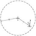
图2为本发明实施例提供的无人机节点的位置分布示意图;FIG. 2 is a schematic diagram of location distribution of UAV nodes according to an embodiment of the present invention;
图3为本发明实施例提供的一种无人机自组网的路由方法的流程示意图二。FIG. 3 is a second schematic flowchart of a routing method for an ad hoc network of a drone according to an embodiment of the present invention.
具体实施方式Detailed ways
为使本发明实施例的目的、技术方案和优点更加清楚,下面将结合附图对本发明的技术方案进行清楚、完整地描述,显然,所描述的实施例是本发明一部分实施例,而不是全部的实施例。基于本发明中的实施例,本领域普通技术人员在没有做出创造性劳动前提下所获得的所有其他实施例,都属于本发明保护的范围。In order to make the purposes, technical solutions and advantages of the embodiments of the present invention clearer, the technical solutions of the present invention will be clearly and completely described below with reference to the accompanying drawings. Obviously, the described embodiments are part of the embodiments of the present invention, but not all of them. example. Based on the embodiments of the present invention, all other embodiments obtained by those of ordinary skill in the art without creative efforts shall fall within the protection scope of the present invention.
目前,无人机自组网大多采用移动自组网网络中的路由技术,主要包括主动式路由技术、被动式路由技术以及混合式路由技术等。主动式路由协议通过网络中各节点周期性地与其附近的节点交换信息,从而更新各节点对整个网络的拓扑信息。每个节点通过收集到的拓扑信息计算到达网络所有节点的最优路径。在拓扑变化较快的网络中,主动式路由网络需频繁更新整个网络的拓扑信息,进一步增大了能量和带宽的消耗以及网络拥塞的可能性。典型的主动式路由协议有优化链路状态路由协议(Optimized Link StateRouting,简称OLSR)、目的节点序列距离矢量协议(Destination-Sequenced Distance-Vector Routing,简称DSDV)等。At present, the UAV ad hoc network mostly adopts the routing technology in the mobile ad hoc network network, mainly including active routing technology, passive routing technology and hybrid routing technology. The active routing protocol periodically exchanges information with the nearby nodes through each node in the network, thereby updating the topology information of each node to the entire network. Each node calculates the optimal path to all nodes in the network through the collected topology information. In a network with rapid topology changes, active routing networks need to frequently update the topology information of the entire network, which further increases the consumption of energy and bandwidth and the possibility of network congestion. Typical active routing protocols include Optimized Link State Routing (OLSR for short), Destination-Sequenced Distance-Vector Routing (DSDV for short) and the like.
被动式路由网络仅在有消息发送时才会通过路由寻找发送路径。在进行路由时,源节点向周围所有节点广播路由请求,收到请求的节点继续向周围所有节点广播源节点的路由请求,直到源节点的路由请求到达目标节点为止。由于该网络仅在有数据传输时维护路由信息,因此减小了网络的开销,但同时增加了数据传输的时延,降低了传输效率。典型的被动式路由协议有无线自组网按需平面距离向量路由协议(Ad hoc On-demandDistance Vector Routing,简称AODV)、动态源路由协议(Dynamic Source Routing,简称DSR)等。A passively routed network finds a sending path through routing only when there is a message to send. During routing, the source node broadcasts the routing request to all surrounding nodes, and the node that receives the request continues to broadcast the routing request of the source node to all surrounding nodes until the routing request of the source node reaches the target node. Since the network only maintains routing information when there is data transmission, the network overhead is reduced, but at the same time, the delay of data transmission is increased, and the transmission efficiency is reduced. Typical passive routing protocols include Ad hoc On-demand Distance Vector Routing (AODV for short) and Dynamic Source Routing (DSR for short) for wireless ad hoc networks.
混合式路由协议混合式协议结合了主动式路由协议和被动式路由协议的特点。典型的混合式路由协议(Zone Routing Protocol,简称ZRP)将网络划分成多个路由区域。区域半径由节点的跳数决定。每个节点在各自的区域内采用主动式路由,在区域外则采用被动式路由。当节点需要发送数据时,首先检查路由表,如果目标节点在该节点的区域内,则从路由表中直接获取路由信息,如果目标节点不在该节点区域内,则开始寻找目标节点。源节点向自己的外围节点广播寻找目标节点的信息,外围节点收到广播信息后开始检查目标节点是否在自己的区域内,如果不在则向自己的外围节点再广播查找信息,直到找到目标节点为止。Hybrid Routing Protocol Hybrid protocol combines the characteristics of active routing protocol and passive routing protocol. A typical hybrid routing protocol (Zone Routing Protocol, ZRP for short) divides the network into multiple routing zones. The area radius is determined by the node's hop count. Each node uses active routing within its own area and passive routing outside the area. When a node needs to send data, it first checks the routing table. If the target node is in the area of the node, it directly obtains the routing information from the routing table. If the target node is not in the area of the node, it starts to search for the target node. The source node broadcasts the information to find the target node to its own peripheral nodes. After receiving the broadcast information, the peripheral node starts to check whether the target node is in its own area. If it is not, it broadcasts the search information to its own peripheral nodes until the target node is found. .
以上这些路由协议应用于无人机自组网均存在一定的不足之处。主动式路由协议有效降低了传输时延但增大了网络开销,被动式路由协议降低了网络开销但增大了传输时延,混合式路由协议综合了主动式路由和被动式路由的优点,但在拓扑变化较快的网络中,区域内的节点可能很快成为区域外的节点,而区域外的节点也可能成为区域内的节点,从而影响网络的传输效率。The above routing protocols have certain shortcomings when applied to UAV ad hoc networks. Active routing protocols effectively reduce the transmission delay but increase network overhead. Passive routing protocols reduce network overhead but increase transmission delay. Hybrid routing protocols combine the advantages of active routing and passive routing, but in topology In a rapidly changing network, the nodes in the area may soon become the nodes outside the area, and the nodes outside the area may also become the nodes in the area, thus affecting the transmission efficiency of the network.
针对无人机自组网高动态拓扑和可借助卫星导航信息,例如GPS、北斗定位等特点,人们又提出了一些新的基于地理位置的路由方法,如贪婪地理转发(GreedyGeographic Forwarding,简称GGF)协议,网络中每个节点均可通过各自地理位置信息的广播获知其余各节点所在的位置,当源节点有数据向发往目标节点时,源节点选择距离目标节点最近的邻居节点作为下一个的中继节点,并将数据转发至该节点。而响应式地理路由(RGR)协议则有效结合了GGF和AODV两种路由方式,通过在AODV协议中增加各节点的地理位置信息,使得网络在未发生链路中断的情况下采用AODV协议,在由无人机高速移动造成链路中断的情况下切换为GGF协议。In view of the high dynamic topology of UAV ad hoc networks and the availability of satellite navigation information, such as GPS, Beidou positioning, etc., some new routing methods based on geographic location have been proposed, such as Greedy Geographic Forwarding (GGF for short). protocol, each node in the network can know the location of the other nodes through the broadcast of their geographic location information. When the source node has data to send to the target node, the source node selects the nearest neighbor node from the target node as the next node. Relay node and forward data to this node. The responsive geographic routing (RGR) protocol effectively combines the two routing methods of GGF and AODV. By adding the geographic location information of each node in the AODV protocol, the network adopts the AODV protocol without link interruption. Switch to the GGF protocol when the link is interrupted due to the high-speed movement of the drone.
然而,上述各种协议在进行路由选择时均未考虑各无人机节点的负载和能量状态以及运动信息,在数据量突增或部分节点能量不足的情况下难以进行高效的数据传输,因此本发明提供了一种无人机自组网的路由方法,综合利用无人机节点的负载、能量信息以及由机载卫星信号接收机(GPS、北斗模块等)获取的位置信息,实现具有较高效率和较高稳定性的路由,保障数据的高质量传播。However, the above-mentioned various protocols do not consider the load and energy status and motion information of each UAV node when performing routing, and it is difficult to carry out efficient data transmission in the case of a sudden increase in the amount of data or insufficient energy of some nodes. The invention provides a routing method for an unmanned aerial vehicle ad hoc network, which comprehensively utilizes the load and energy information of the unmanned aerial vehicle node and the position information obtained by the airborne satellite signal receiver (GPS, Beidou module, etc.) Efficient and highly stable routing ensures high-quality data transmission.
本发明中的无人机自组网采用时分多址模式进行通信。时分多址(Time DivisionMultiple Access,简称TDMA)把时间分割成互不重叠的时段(帧),再将每一帧分割成互不重叠的时隙(信道)。时隙与无人机自组网中的节点一一对应,依据时隙区分来自不同无人机节点的信号,从而完成多址连接。The UAV ad hoc network in the present invention uses the time division multiple access mode to communicate. Time Division Multiple Access (Time Division Multiple Access, TDMA for short) divides time into non-overlapping time periods (frames), and then divides each frame into non-overlapping time slots (channels). The time slot corresponds to the nodes in the UAV ad hoc network one by one, and the signals from different UAV nodes are distinguished according to the time slot, thereby completing the multiple access connection.
在时分多址的通信模式中,每个无人机节点在各自预分配的时隙到来时发送各自的数据。具体的,时分多址模式中的时隙包括控制时隙和数据时隙,控制时隙和数据时隙交替出现。在控制时隙,各无人机节点向邻居节点广播自己的广播信息。每一条广播信息包括节点的位置信息、缓存队列长度、剩余电量信息、时间戳以及接收到的其余节点的最近时间点的位置信息和时间戳,同时侦听各邻居节点的广播信息并收集。经过一轮广播后,每个节点均可获得其所有邻居节点最近时间点的位置信息、缓存队列长度和剩余电量信息。经过多轮广播后,每个节点均可获得网络中各节点在过去几个时间点所处的位置信息。In the communication mode of time division multiple access, each UAV node sends its own data when its pre-assigned time slot arrives. Specifically, the time slot in the time division multiple access mode includes a control time slot and a data time slot, and the control time slot and the data time slot alternately appear. In the control time slot, each UAV node broadcasts its own broadcast information to the neighbor nodes. Each piece of broadcast information includes the location information of the node, the length of the cache queue, the remaining power information, the time stamp, and the received location information and time stamp of the other nodes at the latest time point. At the same time, the broadcast information of each neighbor node is monitored and collected. After a round of broadcasting, each node can obtain the location information, cache queue length and remaining power information of all its neighbor nodes at the latest time point. After multiple rounds of broadcasting, each node can obtain the location information of each node in the network at the past several time points.
因此,可以通过上述获得的信息来构建网络拓扑图,具体如图1所示:Therefore, a network topology map can be constructed from the information obtained above, as shown in Figure 1:
步骤S101、接收当前节点之外的其他节点的位置信息和时间戳。Step S101: Receive location information and time stamps of other nodes other than the current node.
步骤S102、获取时间差阈值,基于时间差阈值与各位置信息的时间戳,过滤当前时间与时间戳的时间差大于时间差阈值的位置信息。Step S102: Obtain a time difference threshold, and filter the location information whose time difference between the current time and the time stamp is greater than the time difference threshold based on the time difference threshold and the time stamp of each location information.
不同于传统网络,无人机自组网属于拓扑变化较快的网络,这体现在区域内的节点可能很快成为区域外的节点,而区域外的节点也可能成为区域内的节点。无人机节点的位置是时刻在变动的,如果对每一个无人机节点的位置信息都不加分析地全部接受,很有可能导致构建出的网络拓扑图与当前时刻的不符。因此,在构建网络拓扑图之前,基于预设置的时间差阈值,对各无人机节点的位置信息进行筛选,筛除时间戳距离当前时刻较远的位置信息,提高构建得到的网络拓扑图的准确程度。Different from the traditional network, the UAV ad hoc network belongs to the network with rapid topology change, which is reflected in the fact that the nodes in the area may quickly become the nodes outside the area, and the nodes outside the area may also become the nodes in the area. The location of the UAV node is changing all the time. If the location information of each UAV node is accepted without analysis, it is likely to cause the constructed network topology map to be inconsistent with the current moment. Therefore, before constructing the network topology map, based on the preset time difference threshold, the location information of each UAV node is screened, and the location information whose timestamp is far away from the current time is filtered out, so as to improve the accuracy of the constructed network topology map. degree.
步骤S103、基于过滤后的位置信息,判断其他各节点之间的连接关系,并判断其他各节点与当前节点的连接关系,得到当前节点对应的连接关系。Step S103 , based on the filtered location information, determine the connection relationship between other nodes, and determine the connection relationship between the other nodes and the current node, and obtain the connection relationship corresponding to the current node.
步骤S104、基于所有节点之间的连接关系,构建网络拓扑图。Step S104 , constructing a network topology map based on the connection relationship between all nodes.
如图2所示,在本发明实施例中,假设网络中的节点最大通信距离为R,而两个无人机节点之间的距离表示为r。对任一无人机节点而言,基于其控制时隙获得的全网各节点位置信息,来判断任意两个无人机节点之间是否相连。以位于o点的无人机节点为当前节点,当另一无人机节点与其的距离r≤R,则判断两无人机节点之间相连,可相互通信,通过一条长度为1的边连接两节点;而当两节点间距离r>R,则判断两节点间不相连。由此得到所需的网络拓扑图。As shown in FIG. 2 , in the embodiment of the present invention, it is assumed that the maximum communication distance of nodes in the network is R, and the distance between two UAV nodes is expressed as r. For any UAV node, it is determined whether any two UAV nodes are connected based on the position information of each node in the whole network obtained by its control time slot. Taking the UAV node located at point o as the current node, when the distance r≤R of another UAV node to it, it is judged that the two UAV nodes are connected and can communicate with each other through an edge with a length of 1. Two nodes; and when the distance between the two nodes is r>R, it is judged that the two nodes are not connected. From this, the required network topology map is obtained.
由于无人机节点的通信距离有限,因此只能接收到位于节点最大通信距离内的邻近的节点的广播信息,即可直接连接的节点的广播信息。而对于无法直接连接的节点的位置信息,就需要通过其他节点的一次甚至是多次转发才能接收到。为了保证接收到的位置信息的时效性,因此需要参考位置信息的时间戳。Since the communication distance of the UAV node is limited, it can only receive the broadcast information of the adjacent nodes within the maximum communication distance of the node, that is, the broadcast information of the directly connected node. For the location information of the node that cannot be directly connected, it needs to be forwarded once or even multiple times by other nodes to receive it. In order to ensure the timeliness of the received location information, it is necessary to refer to the timestamp of the location information.
需要说明的是,对于每一个无人机节点而言,当控制时隙到来时,都需要根据获取到的广播信息,来检验网络拓扑图的是否准确,若是其中的节点位置有变化,则需要及时更新网络拓扑图,保证基于网络拓扑图的数据传输质量。It should be noted that for each UAV node, when the control time slot arrives, it is necessary to check whether the network topology map is accurate according to the obtained broadcast information. Update the network topology map in time to ensure the quality of data transmission based on the network topology map.
进一步的,如图3所示,为无人机自组网中任意无人机节点传送数据包的流程示意图:Further, as shown in Figure 3, it is a schematic diagram of the process of transmitting data packets to any UAV node in the UAV ad hoc network:
步骤S201、获取网络拓扑图。Step S201, acquiring a network topology map.
首先获取根据上文所属的内容构建好的网络拓扑图。First, obtain the network topology map constructed according to the content above.
步骤S202、获取待发送的数据包及其目标节点,结合网络拓扑图和目标节点,获取所有连通目标节点的邻居节点。Step S202: Obtain the data packet to be sent and its target node, and obtain all neighbor nodes connected to the target node in combination with the network topology map and the target node.
假设当前节点为源节点S。当某一源节点S向目标节点D发送数据包时,源节点首先根据已知的网络拓扑图,找出所有可以连通目标节点D的邻居节点。连通目标节点D的邻居节点的集合可表示为W={w1,w2,...,wn}。Suppose the current node is the source node S. When a source node S sends a data packet to a target node D, the source node first finds out all the neighbor nodes that can connect to the target node D according to the known network topology. The set of neighbor nodes connecting the target node D can be expressed as W={w1 , w2 , . . . ,wn }.
步骤S203、获取每一个邻居节点到达目标节点的最短路径。Step S203: Obtain the shortest path from each neighbor node to the target node.
本实施例中,集合内各邻居节点到达目标节点D的最短路径(即到达目标节点D的最少跳数)分别为s1,s2,...,sn。In this embodiment, the shortest paths (ie, the minimum number of hops to reach the target node D) from each neighbor node in the set to the target node D are respectively s1 , s2 , . . . , sn .
步骤S204、接收来自各邻居节点的广播信息。Step S204: Receive broadcast information from each neighbor node.
如前文所述,每一条广播信息包括节点的位置信息、缓存队列长度、剩余电量信息、时间戳以及接收到的其余节点的最近时间点的位置信息和时间戳。As mentioned above, each piece of broadcast information includes the location information of the node, the length of the cache queue, the remaining power information, the time stamp, and the received location information and time stamp of the other nodes at the latest time point.
步骤S205、综合每一个邻居节点的位置信息、缓存队列长度信息、剩余电量信息和最短路径,选取作为传送中继节点的邻居节点,并向传送中继节点传送数据包。Step S205, synthesizing the location information, buffer queue length information, remaining power information and shortest path of each neighbor node, selecting a neighbor node as the transmission relay node, and transmitting the data packet to the transmission relay node.
邻居节点集合W中各邻居节点最近时刻的缓存队列长度依次为l1,l2,...,ln,与源节点S的距离依次为r1,r2,...,rn。如图2所示,可通过各邻居节点的最近两个控制时隙发来的位置信息,计算出各邻居节点的运动方向向量θ。各邻居节点的运动方向向量与各邻居节点到源节点S的空间距离向量所成夹角依次为θ1,θ2,...,θn,各邻居节点的剩余电量依次为E1,E2,...,En。The cache queue lengths of each neighbor node in the neighbor node set W at the latest time are l1 , l2 , ...,ln , and the distances from the source node S are r1 ,r2 , ..., rn . As shown in FIG. 2 , the motion direction vector θ of each neighbor node can be calculated by using the position information sent by the last two control time slots of each neighbor node. The angle formed by the motion direction vector of each neighbor node and the space distance vector from each neighbor node to the source node S is θ1 , θ2 , ..., θn , and the remaining power of each neighbor node is E1 , E2 , ...,En .
为了从集合W的各邻居节点中找出最适合的邻居节点作为中继节点,根据下列四式分别计算pk1,pk2,pk3,pk4(k=1,2,...,n):In order to find the most suitable neighbor node as a relay node from each neighbor node in the set W, calculate pk1 , pk2 , pk3 , pk4 according to the following four formulas respectively (k=1, 2,...,n ):
假设存在一邻居节点k:Suppose there is a neighbor node k:
对于该邻居节点k的最短路径有第一数值pk1:The shortest path for this neighbor node k has a first value pk1 :

对于该邻居节点k的夹角有第二数值pk2:There is a second value pk2 for the included angle of the neighbor node k:

对于该邻居节点k的缓存队列长度有第三数值pk3:The cache queue length for this neighbor node k has a third value pk3 :

对于该邻居节点k的剩余电量信息有第四数值pk4:For the remaining power information of the neighbor node k, there is a fourth value pk4 :
pk4=Ek (4)pk4 =Ek (4)
综合得到选取标识选取邻居节点k为中继节点的选取概率:The selection probability of selecting the neighbor node k as the relay node is comprehensively obtained:
pk=α1pk1+α2pk2+α3pk3+α4pk4 (5)pk =α1 pk1 +α2 pk2 +α3 pk3 +α4 pk4 (5)
其中α1、α2、α3和α4分别为第一权重、第二权重、第三权重和第四权重,具体的α1+α2+α3+α4=1,α1,α2,α3,α4≥0。α1 , α2 , α3 and α4 are the first weight, the second weight, the third weight and the fourth weight, respectively, specifically α1 +α2 +α3 +α4 =1, α1 , α2 , α3 , α4 ≥0.
根据式(1)可知,邻居节点到达目标节点D的跳数越小,则pk1越大,pk越大,即邻居节点到达目标节点的跳数越少,选择该邻居节点的概率越大。According to Equation (1), the smaller the number of hops for the neighbor node to reach the target node D, the larger the pk1 and the larger the pk , that is, the less the number of hops for the neighbor node to reach the target node, the greater the probability of selecting the neighbor node. .
根据式(2),θk一定时,邻居节点与源节点S的距离rk越小时,pk2越大,pk越大;rk一定时,邻居节点的运动方向越靠近S,也就是θk越小时,pk2越大,pk越大。即邻居节点距离源节点越近或运动方向越靠近源节点,则选择该邻居节点的概率越大。According to formula (2), when θk is constant, the smaller the distance rk between the neighbor node and the source node S, the larger pk2 and the larger pk ; when rk is constant, the moving direction of the neighbor node is closer to S, that is, The smaller θk is, the larger pk2 is, and the larger pk is. That is, the closer the neighbor node is to the source node or the closer the motion direction is to the source node, the greater the probability of selecting the neighbor node.
根据式(3),邻居节点的缓存队列长度越短,则pk3越大,pk越大,即邻居节点的负载越小,选择该邻居节点的概率越大。According to formula (3), the shorter the cache queue length of the neighbor node, the larger pk3 and pk , that is, the smaller the load of the neighbor node, the greater the probability of selecting the neighbor node.
根据式(4),邻居节点的剩余电量越多,则pk4越大,pk越大,选择该邻居节点的概率越大。According to formula (4), the more the remaining power of the neighbor node, the larger the pk4 , the larger the pk , the greater the probability of selecting the neighbor node.
根据式(5),源节点S在邻居节点中选择中继节点的概率pk为pk1,pk2,pk3,pk4的加权平均数。当无人机自组网中各无人机节点能量充足,运行时间较长,且传输的数据量不大时,增大pk1的权重可以降低转发数据的平均次数,从而降低传输时延,提高网络吞吐量;当无人机自组网中需要传输大量数据时,增大pk2的权重可提高网络中各无人机节点间的负载均衡,从而降低网络拥塞的可能性。当无人机自组网中各无人机节点的能量有限,部分节点因电量不足无法工作导致网络中部分数据无法转发甚至丢失时,增大pk4的权重可以提高各节点间的能量均衡,从而延长整个网络的工作时长。在实际场景中,pk1,pk2,pk3,pk4的权重α1,α2,α3,α4可通过检测网络中的拥塞情况和各节点运行时长进行自适应调整。According to formula (5), the probability pk of the source node S selecting the relay node among the neighbor nodes is the weighted average of pk1 , pk2 , pk3 , and pk4 . When the energy of each UAV node in the UAV ad hoc network is sufficient, the running time is long, and the amount of data transmitted is not large, increasing the weight of pk1 can reduce the average number of data forwarding, thereby reducing the transmission delay. Improve network throughput; when a large amount of data needs to be transmitted in the UAV ad hoc network, increasing the weight of pk2 can improve the load balancing among UAV nodes in the network, thereby reducing the possibility of network congestion. When the energy of each UAV node in the UAV ad hoc network is limited, and some nodes cannot work due to insufficient power, some data in the network cannot be forwarded or even lost, increasing the weight of pk4 can improve the energy balance between nodes. Thereby extending the working time of the entire network. In actual scenarios, the weights α1 , α2 , α3 , and α4 of pk1 , pk2 , pk3 , and pk4 can be adaptively adjusted by detecting the congestion in the network and the running time of each node.
经过控制时隙,如果目标节点D即为待发送数据的源节点S的邻居节点,则直接将数据发送至该邻居节点。否则源节点选择出待发送数据的中继节点,并在预分配的数据时隙将数据发送到选定的中继节点。在下一个控制时隙,该中继节点按照上述的、同样的方式选择其的邻居节点作为中继节点或目标节点转发数据包,直到该数据包被目的节点接收为止。After the control time slot, if the target node D is the neighbor node of the source node S to be sent data, the data is directly sent to the neighbor node. Otherwise, the source node selects the relay node to send the data, and sends the data to the selected relay node in the pre-assigned data time slot. In the next control time slot, the relay node selects its neighbor node as the relay node or the target node to forward the data packet in the same manner as described above, until the data packet is received by the target node.
通过上述无人机自组网路由方法,可以在一定程度上提高无人机自组网在运行过程中的稳定性和吞吐量。当网络处于低负载时,提高最短路径策略的权重可有效降低数据传输时延;当网络处于高负载时,提高负载均衡策略的权重可降低网络拥塞的概率,从而降低数据的平均传输时延;当网络中部分节点处于低电量时,提高能量均衡策略权重可有效提延长网络的有效工作时长和减少数据的丢失。Through the above-mentioned UAV ad hoc network routing method, the stability and throughput of the UAV ad hoc network during operation can be improved to a certain extent. When the network is under low load, increasing the weight of the shortest path strategy can effectively reduce the data transmission delay; when the network is under high load, increasing the weight of the load balancing strategy can reduce the probability of network congestion, thereby reducing the average data transmission delay; When some nodes in the network are in low power, increasing the weight of the energy balance strategy can effectively prolong the effective working time of the network and reduce the loss of data.
综上,本发明提供了一种无人机自组网的路由方法,该路由方法综合利用无人机节点的负载、能量信息以及由机载卫星信号接收机(GPS、北斗模块等)获取的位置信息,实现具有较高效率和较高稳定性的路由,保障数据的高质量传播。To sum up, the present invention provides a routing method for an ad hoc network of unmanned aerial vehicles, which comprehensively utilizes the load and energy information of the unmanned aerial vehicle node and the information obtained by the airborne satellite signal receiver (GPS, Beidou module, etc.). Location information, realize routing with high efficiency and high stability, and ensure high-quality transmission of data.
最后应说明的是:以上所述实施例,仅为本发明的具体实施方式,用以说明本发明的技术方案,而非对其限制,本发明的保护范围并不局限于此,尽管参照前述实施例对本发明进行了详细的说明,本领域的普通技术人员应当理解:任何熟悉本技术领域的技术人员在本发明揭露的技术范围内,其依然可以对前述实施例所记载的技术方案进行修改或可轻易想到变化,或者对其中部分技术特征进行等同替换;而这些修改、变化或者替换,并不使相应技术方案的本质脱离本发明实施例技术方案的精神和范围,都应涵盖在本发明的保护范围之内。因此,本发明的保护范围应所述以权利要求的保护范围为准。Finally, it should be noted that the above-mentioned embodiments are only specific implementations of the present invention, and are used to illustrate the technical solutions of the present invention, but not to limit them. The protection scope of the present invention is not limited thereto, although referring to the foregoing The embodiment has been described in detail the present invention, and those of ordinary skill in the art should understand: any person skilled in the art who is familiar with the technical field of the present invention can still modify the technical solutions described in the foregoing embodiments within the technical scope disclosed by the present invention. Or can easily think of changes, or equivalently replace some of the technical features; and these modifications, changes or replacements do not make the essence of the corresponding technical solutions deviate from the spirit and scope of the technical solutions of the embodiments of the present invention, and should be covered in the present invention. within the scope of protection. Therefore, the protection scope of the present invention should be based on the protection scope of the claims.
Claims (10)
Priority Applications (1)
| Application Number | Priority Date | Filing Date | Title |
|---|---|---|---|
| CN201810299441.4ACN108600942B (en) | 2018-04-04 | 2018-04-04 | A Routing Method for UAV Ad Hoc Network |
Applications Claiming Priority (1)
| Application Number | Priority Date | Filing Date | Title |
|---|---|---|---|
| CN201810299441.4ACN108600942B (en) | 2018-04-04 | 2018-04-04 | A Routing Method for UAV Ad Hoc Network |
Publications (2)
| Publication Number | Publication Date |
|---|---|
| CN108600942A CN108600942A (en) | 2018-09-28 |
| CN108600942Btrue CN108600942B (en) | 2020-11-13 |
Family
ID=63624439
Family Applications (1)
| Application Number | Title | Priority Date | Filing Date |
|---|---|---|---|
| CN201810299441.4AActiveCN108600942B (en) | 2018-04-04 | 2018-04-04 | A Routing Method for UAV Ad Hoc Network |
Country Status (1)
| Country | Link |
|---|---|
| CN (1) | CN108600942B (en) |
Families Citing this family (34)
| Publication number | Priority date | Publication date | Assignee | Title |
|---|---|---|---|---|
| CN109803342B (en)* | 2018-10-31 | 2023-12-26 | 南京大学 | Unmanned aerial vehicle self-organizing network routing method oriented to energy balance |
| CN109510656A (en)* | 2018-11-26 | 2019-03-22 | 中国人民解放军军事科学院国防科技创新研究院 | A kind of self-adapting data distribution method suitable for unmanned plane group |
| CN109660462B (en)* | 2018-12-13 | 2021-07-20 | 中国北方车辆研究所 | Information self-adaptive transmission method in vehicle heterogeneous interconnection network |
| CN109699060B (en)* | 2018-12-17 | 2022-12-06 | 江汉大学 | Communication method and device of wireless sensor network |
| CN109600312B (en)* | 2019-01-04 | 2021-03-12 | 南京邮电大学 | BATMAN-Adv protocol optimization design method for intelligent terminal ad hoc network |
| CN109688614B (en)* | 2019-01-14 | 2021-04-02 | 西安电子科技大学 | Implementation method and system for high-dynamic unmanned aerial vehicle ad hoc network routing protocol |
| CN109548084B (en)* | 2019-01-17 | 2021-11-30 | 重庆邮电大学 | Load-balanced efficient multi-hop TDMA (time division multiple Access) access method for ad hoc network of unmanned aerial vehicle |
| CN109874162B (en)* | 2019-03-21 | 2023-03-31 | 东南大学 | Hybrid routing protocol design optimization method for high-altitude high-speed mobile node ad hoc network |
| CN110445720B (en)* | 2019-07-26 | 2022-04-12 | 北京神导科讯科技发展有限公司 | Routing table updating method and device, aircraft and storage medium |
| CN110471445B (en)* | 2019-08-22 | 2023-02-21 | 合肥工业大学 | Multi-stage multi-objective optimization method and device for communication energy consumption of multiple unmanned platforms |
| CN110958661B (en)* | 2019-11-25 | 2021-11-05 | 北京邮电大学 | A UAV network routing selection method, device and UAV node |
| CN110691404A (en)* | 2019-12-11 | 2020-01-14 | 浙江天地人科技有限公司 | Multi-level link data uploading and issuing method |
| CN111148049B (en)* | 2019-12-31 | 2021-11-09 | 上海钧正网络科技有限公司 | Vehicle position reporting method and device, computer equipment and storage medium |
| CN111212404A (en)* | 2020-01-10 | 2020-05-29 | 北京猎户星空科技有限公司 | Robot communication method, system, device, robot and storage medium |
| CN111263419B (en)* | 2020-01-17 | 2021-12-28 | 西安交通大学 | Unmanned aerial vehicle-based dynamic routing method for stereo heterogeneous network in emergency scene |
| US11438823B2 (en)* | 2020-05-29 | 2022-09-06 | Huawei Technologies Co., Ltd. | Orthodromic routing |
| CN111601330B (en)* | 2020-06-23 | 2023-09-26 | 上海材料研究所有限公司 | Method and equipment for wireless relay transmission based on geographic position |
| CN112235759B (en)* | 2020-09-15 | 2022-05-17 | 武汉工程大学 | A multi-robot routing optimization method and device |
| CN112381160B (en)* | 2020-11-18 | 2024-04-09 | 北京知道创宇信息技术股份有限公司 | Node identity information acquisition method and device, storage medium and electronic equipment |
| CN112788699B (en)* | 2020-12-30 | 2022-07-12 | 北京邮电大学 | A method and system for determining network topology of a flying ad hoc network |
| CN113260012B (en)* | 2021-05-31 | 2021-09-28 | 四川腾盾科技有限公司 | Unmanned aerial vehicle cluster topology control method based on position track prediction |
| CN113347598A (en)* | 2021-06-18 | 2021-09-03 | 郑州航空工业管理学院 | Situation awareness-based unmanned aerial vehicle ad hoc network routing implementation method |
| CN113867382B (en)* | 2021-09-01 | 2023-11-24 | 西安电子科技大学广州研究院 | Topology control method of unmanned aerial vehicle cluster network |
| CN114025434B (en)* | 2021-11-05 | 2024-02-20 | 江西洪都航空工业集团有限责任公司 | Communication network topology structure self-adaptive reconstruction method and device |
| CN114125982B (en)* | 2021-11-10 | 2023-12-01 | 浙江大学 | Ring directed routing method and storage medium for unmanned system self-organizing network |
| CN113840257B (en)* | 2021-11-25 | 2022-03-11 | 中国电子科技集团公司第二十八研究所 | Multi-unmanned aerial vehicle communication relay method in urban environment |
| CN114302477B (en)* | 2021-12-22 | 2024-08-27 | 山东芯慧微电子科技有限公司 | Unmanned aerial vehicle ad hoc network communication reliability optimization method based on FPGA |
| CN114422444B (en)* | 2022-01-26 | 2023-12-19 | 华北电力大学 | Network congestion control method and system for power transmission line unmanned aerial vehicle inspection |
| CN115242290B (en)* | 2022-06-13 | 2023-10-13 | 北京邮电大学 | Method and device for optimizing OLSR protocol of emergency unmanned aerial vehicle network |
| CN114786235A (en)* | 2022-06-21 | 2022-07-22 | 广州慧睿思通科技股份有限公司 | Mobile ad hoc network communication method, device, system and storage medium |
| CN115551048A (en)* | 2022-09-20 | 2022-12-30 | 深圳市视晶无线技术有限公司 | A wireless ad hoc network communication method, device and electronic equipment |
| CN119071947A (en)* | 2024-08-27 | 2024-12-03 | 南京交通职业技术学院 | UAV cluster self-organizing network communication method and system |
| CN119603220B (en)* | 2024-11-05 | 2025-09-19 | 北京智芯微电子科技有限公司 | Unmanned aerial vehicle ad hoc network routing method and device, unmanned aerial vehicle and readable storage medium |
| CN119629696A (en)* | 2025-02-11 | 2025-03-14 | 交通运输部天津水运工程科学研究所 | Topology reconstruction method, device, equipment and storage medium for waterway monitoring network |
Citations (3)
| Publication number | Priority date | Publication date | Assignee | Title |
|---|---|---|---|---|
| CN101547491A (en)* | 2009-04-15 | 2009-09-30 | 电子科技大学 | Routing method for mobile ad hoc network system |
| CN102802228A (en)* | 2012-08-23 | 2012-11-28 | 西北工业大学 | AdHoc network multipath routing method oriented to link stability |
| CN104038965A (en)* | 2014-06-10 | 2014-09-10 | 南京邮电大学 | Opportunistic routing method capable of efficiently utilizing energy, for mobile wireless sensor network |
Family Cites Families (1)
| Publication number | Priority date | Publication date | Assignee | Title |
|---|---|---|---|---|
| CN102026329B (en)* | 2009-09-10 | 2013-10-30 | 富士通株式会社 | Wireless communication network and self-adaptive route selecting communication method thereof |
- 2018
- 2018-04-04CNCN201810299441.4Apatent/CN108600942B/enactiveActive
Patent Citations (3)
| Publication number | Priority date | Publication date | Assignee | Title |
|---|---|---|---|---|
| CN101547491A (en)* | 2009-04-15 | 2009-09-30 | 电子科技大学 | Routing method for mobile ad hoc network system |
| CN102802228A (en)* | 2012-08-23 | 2012-11-28 | 西北工业大学 | AdHoc network multipath routing method oriented to link stability |
| CN104038965A (en)* | 2014-06-10 | 2014-09-10 | 南京邮电大学 | Opportunistic routing method capable of efficiently utilizing energy, for mobile wireless sensor network |
Non-Patent Citations (2)
| Title |
|---|
| 一种具有速度与能量意识的路由协议;刘济铭;《通信技术》;20130131;第46卷(第1期);全文* |
| 无人机自组网络多媒体数据传输路由算法研究;石祥滨 等;《沈阳航空航天大学学报》;20120430;第29卷(第2期);第1-2部分* |
Also Published As
| Publication number | Publication date |
|---|---|
| CN108600942A (en) | 2018-09-28 |
Similar Documents
| Publication | Publication Date | Title |
|---|---|---|
| CN108600942B (en) | A Routing Method for UAV Ad Hoc Network | |
| CN110149671B (en) | Routing method of unmanned aerial vehicle swarm network | |
| Pu | Jamming-resilient multipath routing protocol for flying ad hoc networks | |
| Pu | Link-quality and traffic-load aware routing for UAV ad hoc networks | |
| US11343817B2 (en) | Multi-tier density-aware location-based channel assignment and adaptive power control method for mobile ad-hoc networks | |
| EP1936889B1 (en) | Location aware packet routing in an ad-hoc network | |
| EP1936888B1 (en) | Distance adaptive routing protocol | |
| US8208382B2 (en) | Method for estimating and signalling the density of mobile nodes in a road network | |
| US7352750B2 (en) | Mobile terminal, control device and mobile communication method | |
| US8254348B2 (en) | Voice-over-internet protocol intra-vehicle communications | |
| CN108040353A (en) | A kind of unmanned plane swarm intelligence Geographic routing method of Q study | |
| CN113115399B (en) | A routing optimization method for heterogeneous UAV self-organizing network | |
| CN111526557B (en) | A wireless ad hoc network routing information acquisition method | |
| KR20210143021A (en) | System for uav assisted relay ad-hoc network system and method based on reinforcement learning | |
| CN114449608A (en) | Unmanned aerial vehicle ad hoc network self-adaptive routing method based on Q-Learning | |
| Pal et al. | Design and implementation of a routing protocol for VANET to improve the QoS of the network | |
| CN105554838A (en) | Frequency coordination and allocation method for multichannel multi-hop vehicular ad hoc network | |
| CN109803342B (en) | Unmanned aerial vehicle self-organizing network routing method oriented to energy balance | |
| Harounabadi et al. | TAG: Trajectory aware geographical routing in cognitive radio ad hoc networks with UAV nodes | |
| CN117915427B (en) | Space perception routing method for aviation self-organizing network based on position prediction | |
| CN108112046A (en) | A kind of routing scheduling method based on vehicle-mounted internet | |
| Mir et al. | Infrastructure-assisted joint power adaptation and routing for heterogeneous vehicular networks | |
| CN114339929B (en) | Aviation cluster network routing method | |
| KR20230155244A (en) | Routing system for internet of vehicles network | |
| Selvakanmani et al. | Overview and literature survey on routing protocols for mobile cognitive radio ad hoc networks |
Legal Events
| Date | Code | Title | Description |
|---|---|---|---|
| PB01 | Publication | ||
| PB01 | Publication | ||
| SE01 | Entry into force of request for substantive examination | ||
| SE01 | Entry into force of request for substantive examination | ||
| GR01 | Patent grant | ||
| GR01 | Patent grant | ||
| CB03 | Change of inventor or designer information | Inventor after:Wang Jian Inventor after:Shi Jinming Inventor after:Shen Yuan Inventor after:Zhao Yu Inventor before:Wang Jian Inventor before:Shi Jinming Inventor before:Shen Yuan | |
| CB03 | Change of inventor or designer information |