CN108256574B - Robot positioning method and device - Google Patents
Robot positioning method and deviceDownload PDFInfo
- Publication number
- CN108256574B CN108256574BCN201810041205.2ACN201810041205ACN108256574BCN 108256574 BCN108256574 BCN 108256574BCN 201810041205 ACN201810041205 ACN 201810041205ACN 108256574 BCN108256574 BCN 108256574B
- Authority
- CN
- China
- Prior art keywords
- robot
- current
- map
- pose
- category
- Prior art date
- Legal status (The legal status is an assumption and is not a legal conclusion. Google has not performed a legal analysis and makes no representation as to the accuracy of the status listed.)
- Active
Links
Images


Classifications
- G—PHYSICS
- G06—COMPUTING OR CALCULATING; COUNTING
- G06F—ELECTRIC DIGITAL DATA PROCESSING
- G06F18/00—Pattern recognition
- G06F18/20—Analysing
- G06F18/22—Matching criteria, e.g. proximity measures
- G—PHYSICS
- G06—COMPUTING OR CALCULATING; COUNTING
- G06F—ELECTRIC DIGITAL DATA PROCESSING
- G06F18/00—Pattern recognition
- G06F18/20—Analysing
- G06F18/23—Clustering techniques
- G—PHYSICS
- G06—COMPUTING OR CALCULATING; COUNTING
- G06V—IMAGE OR VIDEO RECOGNITION OR UNDERSTANDING
- G06V10/00—Arrangements for image or video recognition or understanding
- G06V10/40—Extraction of image or video features
- G06V10/46—Descriptors for shape, contour or point-related descriptors, e.g. scale invariant feature transform [SIFT] or bags of words [BoW]; Salient regional features
- G06V10/462—Salient features, e.g. scale invariant feature transforms [SIFT]
Landscapes
- Engineering & Computer Science (AREA)
- Theoretical Computer Science (AREA)
- Data Mining & Analysis (AREA)
- Computer Vision & Pattern Recognition (AREA)
- General Physics & Mathematics (AREA)
- Physics & Mathematics (AREA)
- Bioinformatics & Cheminformatics (AREA)
- Evolutionary Biology (AREA)
- Evolutionary Computation (AREA)
- Bioinformatics & Computational Biology (AREA)
- General Engineering & Computer Science (AREA)
- Artificial Intelligence (AREA)
- Life Sciences & Earth Sciences (AREA)
- Multimedia (AREA)
- Manipulator (AREA)
- Control Of Position, Course, Altitude, Or Attitude Of Moving Bodies (AREA)
- Image Analysis (AREA)
- Image Processing (AREA)
Abstract
Description
Translated fromChinese技术领域technical field
本发明涉及机器人定位领域,特别是涉及一种机器人定位方法及装置。The invention relates to the field of robot positioning, in particular to a robot positioning method and device.
背景技术Background technique
近年来机器人尤其是自主移动机器人已经成为一个重要研究领域。机器人可以代替人进行复杂作业或高危作业。机器人在作业过程中,多会碰到在未知环境作业的情况,此时机器人的定位与地图构建能力显得尤为重要。Robots, especially autonomous mobile robots, have become an important research field in recent years. Robots can replace humans in complex or high-risk operations. During the operation of the robot, it will often encounter the situation of working in an unknown environment. At this time, the robot's positioning and map construction capabilities are particularly important.
目前,传统技术中多采用以下两种方式实现机器人的定位与地图构建:一种是利用激光传感器得到比较准确的距离信息,主要是利用激光构建栅格地图进行定位,易于做路径规划和导航;然而激光感知环境的信息量较少,只能获取环境的平面信息,对环境的识别度不高,进行机器人初始位置匹配时的误差大。At present, the following two methods are used to realize the positioning and map construction of robots in traditional technologies: one is to use laser sensors to obtain relatively accurate distance information, mainly to use lasers to construct grid maps for positioning, which is easy to do path planning and navigation; However, the amount of information of the laser perception environment is small, and it can only obtain the plane information of the environment, and the recognition degree of the environment is not high, and the error when matching the initial position of the robot is large.
另一种是利用视觉传感器对场景地点进行识别。基于视觉传感器的方法由于采集环境信息较丰富,有助于对动态场景的信息处理,在回环检测和数据关联方面比激光有较好的效果,但是目前视觉定位技术不是很成熟,存在计算耗时较大,定位精度不如激光等缺点。The other is to use visual sensors to identify scene locations. The method based on visual sensor is helpful for information processing of dynamic scenes due to the rich collection of environmental information, and has better effect than laser in loopback detection and data association, but the current visual positioning technology is not very mature, and it is time-consuming to calculate Larger, the positioning accuracy is not as good as that of lasers.
针对以上两种机器人定位与地图构建方法的不足,提出了一种融合视觉和激光共同定位的方法:在地图构建准备环节,利用激光构建平面激光地图,同时利用机器人相机建立三维重构地图,并将三维重构地图与平面激光地图进行尺度统一。在机器人进行初始化定位环节,对机器人相机采集环境信息得到的环境图像进行特征点提取,建立二维特征点在三维重构地图的对应关系,求解获取当前图像的机器人在三维重构地图中的位置,通过平面激光地图和三维重构地图的对应关系求解当前机器人在平面激光地图的位置。Aiming at the shortcomings of the above two methods of robot positioning and map construction, a method that integrates vision and laser co-location is proposed: in the map construction preparation process, the laser is used to construct a plane laser map, and the robot camera is used to construct a three-dimensional reconstruction map. Unify the scale of the 3D reconstructed map and the planar laser map. In the initial positioning process of the robot, the feature points are extracted from the environmental image obtained by the robot camera collecting the environmental information, the corresponding relationship between the two-dimensional feature points in the three-dimensional reconstructed map is established, and the position of the robot that obtains the current image in the three-dimensional reconstructed map is solved. , and solve the current position of the robot on the plane laser map through the correspondence between the plane laser map and the three-dimensional reconstructed map.
但发明人在实施过程中,发现传统技术至少存在以下技术问题:传统技术中只通过对环境图像的特征点提取及激光平面地图、三维重构地图的对应关系,得到机器人的位置,定位精度低。However, in the process of implementation, the inventor found that the traditional technology has at least the following technical problems: the traditional technology only obtains the position of the robot by extracting the feature points of the environmental image and the corresponding relationship between the laser plane map and the three-dimensional reconstructed map, and the positioning accuracy is low. .
发明内容SUMMARY OF THE INVENTION
基于此,有必要针对机器人定位精度低问题,提供一种机器人定位方法及装置。Based on this, it is necessary to provide a robot positioning method and device for the problem of low robot positioning accuracy.
一方面,本发明实施例提供了一种机器人定位方法,包括:On the one hand, an embodiment of the present invention provides a method for positioning a robot, including:
读取机器人相机的当前检索图像,并将当前检索图像与混合视觉激光地图进行相似度度量,查找当前检索图像中相似度最高的前m帧;Read the current retrieval image of the robot camera, measure the similarity between the current retrieval image and the hybrid vision laser map, and find the first m frames with the highest similarity in the current retrieval image;
对前m帧进行多个类别的聚类,并将各聚类类别与上一次检索图像对应的聚类类别进行匹配,判断是否产生新聚类类别;The first m frames are clustered in multiple categories, and each cluster category is matched with the cluster category corresponding to the last retrieved image to determine whether a new cluster category is generated;
若检测到新聚类类别,则对当前检索图像和当前检索图像对应的各聚类类别的中心关键帧图像进行局部特征匹配,并根据局部特征匹配结果获得与类别个数相同的多个机器人的当前位姿;If a new cluster category is detected, perform local feature matching on the current retrieval image and the central key frame image of each cluster category corresponding to the current retrieval image, and obtain the number of robots with the same number of categories according to the local feature matching result. current pose;
读取机器人的激光传感器的当前扫描数据,获得当前扫描数据与混合视觉激光地图的重合度得分,并对各聚类类别的重合度得分进行排序;Read the current scan data of the robot's laser sensor, obtain the coincidence score between the current scan data and the hybrid vision laser map, and sort the coincidence score of each clustering category;
若检测到得分最高的类别是新聚类类别时,则将该新聚类类别的中心关键帧图像对应的位姿信息更新为机器人的当前位姿。If it is detected that the class with the highest score is a new cluster class, the pose information corresponding to the central key frame image of the new cluster class is updated to the current pose of the robot.
在其中一个实施例中,在判断是否产生新聚类类别的步骤之后还包括步骤:In one of the embodiments, after the step of judging whether to generate a new cluster category, the step further includes:
若未检测到新聚类类别,则存储当前的扫描数据,并根据机器人里程信息、相邻的两帧扫描数据和定位算法获得机器人下一时刻的位姿,并将下一时刻的位姿更新为机器人的当前位姿。If no new clustering category is detected, the current scan data is stored, and the robot's pose at the next moment is obtained according to the robot's mileage information, two adjacent frames of scan data and the positioning algorithm, and the next moment's pose is updated. is the current pose of the robot.
在其中一个实施例中,在读取机器人相机的当前检索图像之前还包括步骤:In one of the embodiments, before reading the current retrieved image of the robot camera, it further includes the steps:
利用激光传感器和机器人相机离线构建混合视觉激光地图;其中,混合视觉激光地图为视觉特征地图的视觉特征与激光平面地图的位姿信息一一对应的地图。The hybrid vision laser map is constructed offline by using laser sensors and robot cameras; wherein, the hybrid vision laser map is a map in which the visual features of the visual feature map and the pose information of the laser plane map correspond one-to-one.
在其中一个实施例中,利用激光传感器和机器人相机离线构建混合视觉激光地图的步骤包括:In one embodiment, the step of offline building a hybrid vision laser map using laser sensors and robotic cameras includes:
获取机器人里程信息;Get robot mileage information;
控制激光传感器对周围环境进行扫描,得到当前扫描数据,同时读取机器人相机的关键帧图像;Control the laser sensor to scan the surrounding environment, get the current scan data, and read the key frame image of the robot camera at the same time;
初始化机器人的位置并存储当前扫描数据,根据机器人里程信息得到机器人下一时刻的预测位置,对相邻的两帧扫描数据及机器人里程信息采用定位算法得到机器人的位姿信息;Initialize the position of the robot and store the current scanning data, obtain the predicted position of the robot at the next moment according to the mileage information of the robot, and use the positioning algorithm to obtain the pose information of the robot for the adjacent two frames of scanning data and the mileage information of the robot;
控制机器人重复移动,并根据激光传感器采集的扫描数据构建激光平面地图;Control the robot to move repeatedly, and build a laser plane map based on the scan data collected by the laser sensor;
在构建激光平面地图的同时,提取关键帧图像的视觉特征,获得视觉特征地图,并根据视觉特征与位姿信息联合得到视觉特征地图和激光平面地图一一对应的混合视觉激光地图。While constructing the laser plane map, the visual features of the key frame images are extracted to obtain the visual feature map, and the visual feature map and the laser plane map are combined to obtain a one-to-one hybrid visual laser map according to the visual features and the pose information.
在其中一个实施例中,提取关键帧图像的视觉特征的步骤包括:In one of the embodiments, the step of extracting the visual features of the key frame images includes:
通过Gist全局描述算子提取并存储关键帧图像的视觉特征。The visual features of key frame images are extracted and stored through the Gist global description operator.
在其中一个实施例中,根据局部特征匹配结果获得与类别个数相同的多个机器人的当前位姿的步骤包括步骤:In one of the embodiments, the step of obtaining the current poses of multiple robots with the same number of categories according to the local feature matching result includes the steps of:
对匹配内点数超过预设阈值的各聚类类别采用PnP法得到机器人的当前位姿。The PnP method is used to obtain the current pose of the robot for each cluster category whose matching points exceed the preset threshold.
在其中一个实施例中,根据局部特征匹配结果获得与类别个数相同的多个机器人的当前位姿的步骤还包括步骤:In one of the embodiments, the step of obtaining the current poses of multiple robots with the same number of categories according to the local feature matching result further includes the steps of:
对匹配内点数未超过预设阈值的各聚类类别,将其对应的中心关键帧图像的位姿作为机器人当前位姿。For each cluster category whose matching points do not exceed the preset threshold, the pose of the corresponding central key frame image is taken as the current pose of the robot.
在其中一个实施例中,对前m帧进行多个类别的聚类的步骤包括:In one of the embodiments, the step of clustering the first m frames of multiple categories includes:
对前m帧的索引采用k-means聚类方法进行k个类别的聚类,得到k个聚类类别的排序;The k-means clustering method is used for the index of the first m frames to cluster k categories, and the ranking of the k cluster categories is obtained;
将每个聚类类别的中心值替换该类别关键帧索引的中位数,以落在每个聚类类别的范围内的帧数为基数,乘以机器人的最大速度因子作为该类别的新范围;Replace the center value of each clustered category with the median of the keyframe index for that category, take the number of frames that fall within the range of each clustered category as the base, and multiply by the robot's maximum speed factor as the new range for that category ;
将配置新范围的k个聚类类别与上一次检索图像对应的k个聚类类别进行匹配。Match the k cluster categories configured with the new range with the k cluster categories corresponding to the last retrieved image.
本发明实施例另一方面还提供一种机器人定位装置,包括:Another aspect of the embodiments of the present invention also provides a robot positioning device, comprising:
图像获取及相似度度量模块,用于读取机器人相机的当前检索图像,并将当前检索图像与混合视觉激光地图进行相似度度量,查找当前检索图像中相似度最高的前m帧;The image acquisition and similarity measurement module is used to read the current retrieval image of the robot camera, measure the similarity between the current retrieval image and the hybrid vision laser map, and find the first m frames with the highest similarity in the current retrieval image;
聚类匹配模块,用于对前m帧进行多个类别的聚类,并将各聚类类别与上一次检索图像对应的聚类类别进行匹配,判断是否产生新聚类类别;The clustering matching module is used for clustering multiple categories of the first m frames, and matching each clustering category with the clustering category corresponding to the last retrieved image, and judging whether a new clustering category is generated;
局部特征匹配模块,用于若检测到新聚类类别,则对当前检索图像和当前检索图像对应的各聚类类别的中心关键帧图像进行局部特征匹配,并根据局部特征匹配结果获得与类别个数相同的多个机器人的当前位姿;The local feature matching module is used to perform local feature matching on the current retrieval image and the central key frame image of each cluster category corresponding to the current retrieval image if a new clustering category is detected, and obtain the corresponding category according to the local feature matching result. The current pose of multiple robots with the same number;
重合度得分模块,用于读取机器人的激光传感器的当前扫描数据,获得当前扫描数据与混合视觉激光地图的重合度得分,并对各聚类类别的重合度得分进行排序;The coincidence score module is used to read the current scanning data of the laser sensor of the robot, obtain the coincidence score between the current scanning data and the hybrid vision laser map, and sort the coincidence score of each clustering category;
位姿更新发布模块,用于若检测到得分最高的类别是新聚类类别时,则将该新聚类类别的中心关键帧图像对应的位姿信息更新为机器人的当前位姿。The pose update and release module is used to update the pose information corresponding to the central key frame image of the new cluster class to the current pose of the robot if it is detected that the class with the highest score is a new cluster class.
一种计算机设备,包括存储器、处理器及存储在存储器上并可在处理器上运行的计算机程序,处理器执行程序时实现上述机器人定位方法的步骤。A computer device includes a memory, a processor, and a computer program stored in the memory and running on the processor. The processor implements the steps of the above-mentioned robot positioning method when the program is executed.
一种计算机可读存储介质,其上存储有计算机程序,该程序被处理器执行时实现上述机器人定位方法的步骤。A computer-readable storage medium on which a computer program is stored, when the program is executed by a processor, implements the steps of the above-mentioned robot positioning method.
上述机器人定位方法及装置,通过机器人相机获取当前检索图像,并将当前检索图像与混合视觉激光地图进行相似度度量,查找当前检索图像中相似度最高的前m帧;并对前m帧进行聚类匹配,判断是否产生新聚类类别;当检测到新聚类类别时,则对当前检索图像和当前检索图像对应的各聚类类别的中心关键帧图像进行局部特征匹配,并根据局部特征匹配结果获得与类别个数相同的多个机器人的当前位姿;再通过获取机器人的激光传感器的当前扫描数据,并将当前扫描数据与混合视觉激光地图的重合度得分进行排序,当检测到得分最高的类别是新聚类类别时,则将该新聚类类别的中心关键帧图像对应的位姿信息更新为机器人的当前位姿,从而实现精确定位。本发明实施例中的机器人定位方法及装置结合视觉特征地图和激光平面地图,采用聚类匹配、重合度得分机制,增加对机器人对环境的识别率,从而提高定位准确度。The above robot positioning method and device obtain the current retrieval image through the robot camera, measure the similarity between the current retrieval image and the hybrid vision laser map, and find the first m frames with the highest similarity in the current retrieval image; and gather the first m frames. Class matching to determine whether a new clustering category is generated; when a new clustering category is detected, local feature matching is performed on the current retrieval image and the central key frame image of each clustering category corresponding to the current retrieval image, and the matching is performed according to the local features. As a result, the current poses of multiple robots with the same number of categories are obtained; then, the current scan data of the robot's laser sensor is obtained, and the current scan data and the overlap score of the hybrid vision laser map are sorted. When the highest score is detected When the category of is a new cluster category, the pose information corresponding to the central key frame image of the new cluster category is updated to the current pose of the robot, so as to achieve precise positioning. The robot positioning method and device in the embodiments of the present invention combine the visual feature map and the laser plane map, and adopt the cluster matching and coincidence degree scoring mechanism to increase the recognition rate of the robot to the environment, thereby improving the positioning accuracy.
附图说明Description of drawings
图1为本发明实施例一应用场景说明图;FIG. 1 is an explanatory diagram of an application scenario of Embodiment 1 of the present invention;
图2为本发明机器人定位方法实施例的第一流程示意图;2 is a first schematic flow chart of an embodiment of a robot positioning method according to the present invention;
图3为本发明机器人定位方法实施例的第二流程示意图;3 is a second schematic flowchart of an embodiment of a robot positioning method according to the present invention;
图4为本发明机器人定位方法实施例的第三流程示意图;4 is a third schematic flowchart of an embodiment of a robot positioning method according to the present invention;
图5为本发明机器人定位方法中混合视觉激光地图离线构建方法的第一示意流程图;Fig. 5 is the first schematic flow chart of the hybrid vision laser map offline construction method in the robot positioning method of the present invention;
图6为本发明机器人定位方法中混合视觉激光地图离线构建方法的第二示意流程图;Fig. 6 is the second schematic flow chart of the hybrid vision laser map offline construction method in the robot positioning method of the present invention;
图7为本发明机器人定位方法实施例的第四流程示意图;7 is a fourth schematic flowchart of an embodiment of a robot positioning method according to the present invention;
图8为本发明机器人定位方法中对前m帧进行多个类别的聚类的方法流程示意图;8 is a schematic flowchart of a method for clustering multiple categories of first m frames in the robot positioning method of the present invention;
图9为本发明机器人定位装置实施例的第一结构示意图;FIG. 9 is a first structural schematic diagram of an embodiment of a robot positioning device according to the present invention;
图10为本发明机器人定位装置实施例的第二结构示意图。FIG. 10 is a second structural schematic diagram of the embodiment of the robot positioning device of the present invention.
具体实施方式Detailed ways
为了便于理解本发明,下面将参照相关附图对本发明进行更全面的描述。附图中给出了本发明的首选实施例。但是,本发明可以以许多不同的形式来实现,并不限于本文所描述的实施例。相反地,提供这些实施例的目的是使对本发明的公开内容更加透彻全面。In order to facilitate understanding of the present invention, the present invention will be described more fully hereinafter with reference to the related drawings. Preferred embodiments of the invention are shown in the accompanying drawings. However, the present invention may be embodied in many different forms and is not limited to the embodiments described herein. Rather, these embodiments are provided so that this disclosure will be thorough and complete.
除非另有定义,本文所使用的所有的技术和科学术语与属于本发明的技术领域的技术人员通常理解的含义相同。本文中在本发明的说明书中所使用的术语只是为了描述具体的实施例的目的,不是旨在于限制本发明。本文所使用的术语“及/或”包括一个或多个相关的所列项目的任意的和所有的组合。Unless otherwise defined, all technical and scientific terms used herein have the same meaning as commonly understood by one of ordinary skill in the art to which this invention belongs. The terms used herein in the description of the present invention are for the purpose of describing specific embodiments only, and are not intended to limit the present invention. As used herein, the term "and/or" includes any and all combinations of one or more of the associated listed items.
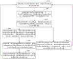
为更好的说明本发明实施例的技术方案,对本发明实施例中的技术方案的应用场景作以下说明:In order to better illustrate the technical solutions of the embodiments of the present invention, the application scenarios of the technical solutions in the embodiments of the present invention are described as follows:
机器人定位是指机器人通过感知获取环境信息,并经过相关的信息处理而确定自身及目标位姿的过程。机器人在未知环境中工作时,需要确定自身位置,以便在实际作业时,能够根据目标位置进行路径规划,因此,机器人定位是极为重要的。例如,如图1所示,机器人在未知环境中,要对目标A进行操作,首先机器人需要确定自身在环境中的位置,然后根据自身位姿和目标A的位姿关系进行路径规划,以移动到目标A的位置并对目标A进行操作,此例子只是机器人定位的一个应用场景的举例,但不限制本发明实施例中提出的机器人定位方法及装置的应用范围。Robot positioning refers to the process that the robot obtains environmental information through perception, and determines its own and target pose through related information processing. When a robot works in an unknown environment, it needs to determine its own position, so that it can plan the path according to the target position during actual operation. Therefore, the positioning of the robot is extremely important. For example, as shown in Figure 1, to operate target A in an unknown environment, the robot first needs to determine its own position in the environment, and then perform path planning according to the pose relationship between its own pose and target A to move This example is just an example of an application scenario of robot positioning, but does not limit the application scope of the robot positioning method and device proposed in the embodiments of the present invention.
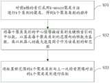
本发明实施例提供了一种机器人定位方法,如图2所示,上述机器人定位方法包括:An embodiment of the present invention provides a method for positioning a robot. As shown in FIG. 2 , the method for positioning a robot includes:
S20:读取机器人相机的当前检索图像,并将当前检索图像与混合视觉激光地图进行相似度度量,查找当前检索图像中相似度最高的前m帧;S20: Read the current retrieval image of the robot camera, measure the similarity between the current retrieval image and the hybrid vision laser map, and find the first m frames with the highest similarity in the current retrieval image;
S30:对前m帧进行多个类别的聚类,并将各聚类类别与上一次检索图像对应的聚类类别进行匹配,判断是否产生新聚类类别;S30: Perform clustering of multiple categories on the first m frames, and match each cluster category with the cluster category corresponding to the last retrieved image to determine whether a new cluster category is generated;
S40:若检测到新聚类类别,则对当前检索图像和当前检索图像对应的各聚类类别的中心关键帧图像进行局部特征匹配,并根据局部特征匹配结果获得与类别个数相同的多个机器人的当前位姿;S40: If a new clustering category is detected, perform local feature matching on the current retrieval image and the central key frame image of each clustering category corresponding to the current retrieval image, and obtain a plurality of the same number of categories according to the local feature matching result The current pose of the robot;
S50:读取机器人的激光传感器的当前扫描数据,获得当前扫描数据与混合视觉激光地图的重合度得分,并对各聚类类别的重合度得分进行排序;S50: Read the current scanning data of the laser sensor of the robot, obtain the coincidence score between the current scanning data and the hybrid vision laser map, and sort the coincidence scores of each clustering category;
S60:若检测到得分最高的类别是新聚类类别时,则将该新聚类类别的中心关键帧图像对应的位姿信息更新为机器人的当前位姿。S60: If it is detected that the category with the highest score is a new cluster category, update the pose information corresponding to the central key frame image of the new cluster category to the current pose of the robot.
其中,混合视觉激光地图中是指包括视觉特征地图和激光平面地图及视觉特征地图、激光平面地图对应关系的地图。前m帧中m参数的选取是通过实验获得的,当取前m帧时,机器人定位精度和速度均能达到较优。上一次检索图像对应的聚类类别是指,机器人在移动过程中,上一次定位时所获取的机器人相机的检索图像与混合视觉激光地图进行相似度度量后,对相似度最高的前m帧进行聚类所生成的聚类类别。新聚类类别是指与上一次检索图像对应的聚类类别不同的类别。重合度得分是指扫描数据和混合视觉激光地图中存储的扫描数据的重合程度的得分,重合的数据点越多,则重合度得分越高。混合视觉激光地图是预先建立好的,混合视觉激光地图中的视觉特征地图是指,包括视觉特征的地图,混合视觉激光地图中的激光平面地图是指利用激光传感器构建的、含扫描数据的地图。The hybrid visual laser map refers to a map including a visual feature map, a laser plane map, and a corresponding relationship between the visual feature map and the laser plane map. The selection of m parameters in the first m frames is obtained through experiments. When the first m frames are taken, the robot positioning accuracy and speed can be better. The clustering category corresponding to the last retrieval image refers to the similarity measurement between the retrieval image of the robot camera obtained during the last positioning of the robot and the hybrid vision laser map during the movement of the robot, and the first m frames with the highest similarity are processed. The cluster category generated by the clustering. The new cluster category refers to a category that is different from the cluster category corresponding to the last retrieved image. The coincidence score refers to the score of the coincidence degree between the scanned data and the scanned data stored in the hybrid vision laser map. The more coincident data points, the higher the coincidence score. The hybrid vision laser map is pre-established. The visual feature map in the hybrid vision laser map refers to the map including visual features, and the laser plane map in the hybrid vision laser map refers to the map constructed by using laser sensors and containing scan data. .
具体的,机器人读取机器人相机的当前检索图像,其中,检索图像可以包括关键帧彩色图像和关键帧深度图像;然后,将当前检索图像与混合视觉激光地图进行相似度度量,查找当前检索图像中相似度最高的前m帧,并对前m帧进行聚类,并与上一次检索图像对应的聚类类别进行匹配,当检测到新聚类类别时,对当前检索图像和当前检索图像对应的各聚类类别的中心关键帧图像进行局部特征匹配,得到与类别个数相同的多个机器人的当前位姿,例如,若前面进行聚类时生成了k个聚类类别,则经过局部特征匹配,将得到k种机器人的当前位姿的可能性。可选的,混合视觉激光地图中还包括视觉特征地图中的视觉特征与激光平面地图中的位姿信息的一一对应关系,所以通过对当前检索图像进行局部特征匹配可以迅速得到机器人的当前位姿的可能性。在进行局部特征匹配后,读取机器人的激光传感器的当前扫描数据,获得当前扫描数据与混合视觉激光地图中的扫描数据的重合度得分,并对各聚类类别的重合度得分进行排序,当检测到得分最高的类别是新聚类类别时,则将该新聚类类别的中心关键帧图像对应的位姿信息更新为机器人的当前位姿。Specifically, the robot reads the current retrieval image of the robot camera, where the retrieval image may include a key frame color image and a key frame depth image; The first m frames with the highest similarity are clustered and matched with the cluster category corresponding to the last retrieval image. When a new cluster category is detected, the current retrieval image and the current retrieval image corresponding The central key frame images of each clustering category are subjected to local feature matching, and the current poses of multiple robots with the same number of categories are obtained. For example, if k cluster categories were generated during the previous clustering, the local feature matching , the probability of the current pose of k robots will be obtained. Optionally, the hybrid vision laser map also includes a one-to-one correspondence between the visual features in the visual feature map and the pose information in the laser plane map, so the current position of the robot can be quickly obtained by performing local feature matching on the current retrieved image. Possibilities of poses. After local feature matching, read the current scan data of the robot's laser sensor, obtain the coincidence score between the current scan data and the scan data in the hybrid vision laser map, and sort the coincidence scores of each cluster category. When it is detected that the class with the highest score is a new cluster class, the pose information corresponding to the central key frame image of the new cluster class is updated to the current pose of the robot.
其中,可选的,进行局部特征匹配时,可以采用基于ORB局部视觉特征提取和匹配方法,还可以是采用SIFT,SURF等局部特征提取和匹配方法。Wherein, optionally, when performing local feature matching, a local visual feature extraction and matching method based on ORB may be used, or a local feature extraction and matching method such as SIFT and SURF may be used.
其中,ORB(ORientedBrief)局部视觉特征提取和匹配方法,主要是通过在视觉特征点附近随机选取若干点对,将这些点对的灰度值的大小,组合成一个二进制串,并将这个二进制串作为该特征点的特征描述子,并根据该特征描述子来进行匹配的方法。SIFT(Scale-invariant feature transform),尺度不变特征转换,是用于图像处理领域的一种描述子,这种描述具有尺度不变性,可在图像中检测出关键点,是一种局部特征描述子。SURF(SpeededUp RobustFeatures),加速稳健特征,是一个稳健的图像识别描述算法,是基于SIFT算法的一种加速算法。Among them, the ORB (ORientedBrief) local visual feature extraction and matching method is mainly to randomly select several point pairs near the visual feature points, combine the gray value of these point pairs into a binary string, and combine the binary string. As the feature descriptor of the feature point, and matching method according to the feature descriptor. SIFT (Scale-invariant feature transform), scale-invariant feature transform, is a descriptor used in the field of image processing. This description has scale invariance and can detect key points in the image. It is a local feature description son. SURF (SpeededUp RobustFeatures), accelerated robust features, is a robust image recognition description algorithm, is an accelerated algorithm based on the SIFT algorithm.
可选的,将当前检索图像与混合视觉激光地图进行相似度度量的过程可以包括:Optionally, the process of measuring the similarity between the current retrieval image and the hybrid vision laser map may include:
提取当前检索图像的视觉特征,并将当前检索图像的视觉特征与混合视觉激光地图中的视觉特征进行相似度度量;然后,采用欧氏距离对当前检索图像的视觉特征的视觉特征向量和混合视觉激光地图中的视觉特征的视觉特征向量进行逐一计算,查找相似度最高的前m帧。Extract the visual features of the current retrieval image, and measure the similarity between the visual features of the current retrieval image and the visual features in the hybrid vision laser map; The visual feature vectors of the visual features in the laser map are calculated one by one to find the first m frames with the highest similarity.
可选的,读取机器人相机的当前检索图像,并采用Gist全局描述算子提取当前检索图像的视觉特征。其中,Gist全局描述算子是一种基于空间包络描述图像特征的全局场景描述算子。Optionally, the current retrieval image of the robot camera is read, and the Gist global description operator is used to extract the visual features of the current retrieval image. Among them, the Gist global descriptor is a global scene descriptor that describes image features based on spatial envelopes.
可选的,如图2所示,在步骤S60:若检测到得分最高的类别是新聚类类别时,则将该新聚类类别的中心关键帧图像对应的位姿信息更新为机器人的当前位姿之后,跳转到步骤S20进行下一次定位。可选的,机器人采用定时和定距策略进行下一次的定位。Optionally, as shown in FIG. 2, in step S60: if it is detected that the category with the highest score is a new cluster category, then the pose information corresponding to the central key frame image of the new cluster category is updated to the current status of the robot. After the pose, jump to step S20 to perform the next positioning. Optionally, the robot uses timing and fixed distance strategies for the next positioning.
可选的,对前m帧进行聚类,并对生成的聚类类别进行排序;当检测到得分最高的类别是排序最高的新聚类类别时,则将排序最高的新聚类类别的中心关键帧图像对应的位姿信息更新为机器人的当前位姿。聚类类别的排序顺序代表了机器人对各类别与混合视觉激光地图中的视觉特征匹配的信任程度,重合度得分的得分高低,代表了机器人对各类别与混合视觉激光地图中的激光平面地图匹配的信任程度,选择聚类类别排序最高且得分最高的类别的中心关键帧图像对应的位姿信息作为机器人的当前位姿,实现定位,大幅度提高了机器人的定位精度。Optionally, perform clustering on the first m frames and sort the generated clustering categories; when it is detected that the category with the highest score is the new clustering category with the highest ranking, the center of the new clustering category with the highest ranking will be The pose information corresponding to the key frame image is updated to the current pose of the robot. The sorting order of the clustering categories represents the robot's confidence in the matching of each category with the visual features in the hybrid vision laser map, and the score of the coincidence score represents the robot's matching of each category with the laser plane map in the hybrid vision laser map. The position and orientation information corresponding to the central key frame image of the category with the highest clustering category ranking and the highest score is selected as the current pose of the robot to achieve positioning and greatly improve the positioning accuracy of the robot.
本实施例中提供的机器人定位方法,利用聚类匹配判别是否产生新聚类类别,当生成新聚类类别时,对当前检索图像和各聚类类别的中心关键帧图像进行局部特征匹配,根据匹配结果得到机器人当前位姿的多种可能性,并进一步通过对当前扫描数据和激光平面地图的重合度得分,在得分最高的聚类是新聚类时,即对机器人的当前位姿进行更新,以实现机器人定位,这种利用聚类匹配和重合得分机制结合的方法,大大提高了在机器人定位中,机器人对周围环境的识别率,从而实现精准定位。The robot positioning method provided in this embodiment uses cluster matching to determine whether a new cluster category is generated. When a new cluster category is generated, local feature matching is performed on the currently retrieved image and the central key frame image of each cluster category. The matching result obtains various possibilities of the robot's current pose, and further through the coincidence score of the current scan data and the laser plane map, when the cluster with the highest score is a new cluster, the current pose of the robot is updated. , in order to achieve robot positioning, this method of combining cluster matching and coincidence scoring mechanism greatly improves the recognition rate of the robot to the surrounding environment in the robot positioning, so as to achieve accurate positioning.
在其中一个实施例中,如图3所示,在判断是否产生新聚类类别的步骤之后还包括步骤:In one of the embodiments, as shown in FIG. 3 , after the step of judging whether to generate a new cluster category, the step further includes:
S70:若未检测到新聚类类别,则存储当前的扫描数据,并根据机器人里程信息、相邻的两帧扫描数据和定位算法获得机器人下一时刻的位姿,并将下一时刻的位姿更新为机器人的当前位姿。S70: If no new clustering category is detected, store the current scan data, obtain the pose of the robot at the next moment according to the robot mileage information, the scan data of two adjacent frames and the positioning algorithm, and calculate the position and orientation of the robot at the next moment. The pose is updated to the current pose of the robot.
其中,机器人下一时刻的位姿是指机器人下一个可能在的位置所对应的位姿。相邻的两帧扫描数据是指,机器人当前的扫描数据以及上次定位时所存储的扫描数据。具体的,当机器人未检测到新聚类类别时,机器人根据里程信息预测得到机器人的第一预测位姿,并存储当前的扫描数据,调取上一次定位时所储存的扫描数据,然后根据当前的扫描数据、上一次定位时存储的扫描数据得到第二预测位姿,将第一预测位姿和第二预测位姿通过定位算法,得到机器人下一时刻的位姿,并将计算得到的下一时刻的位姿作为机器人的当前位姿。其中,定位算法可以采用Rao-Blackwellised粒子滤波器算法、扩展卡尔曼滤波器算法等。Rao-Blackwellised粒子滤波器算法是通过引入边缘函数从而提高估计精度的一种算法,扩展卡尔曼滤波器算法(Extended Kalman Filter)是一种高效率的递归滤波器算法。可选的,通过机器人的里程计得到机器人里程信息,还可以通过机器人的轮子里程计得到机器人里程信息。Among them, the pose of the robot at the next moment refers to the pose corresponding to the next possible position of the robot. The adjacent two frames of scan data refer to the current scan data of the robot and the scan data stored in the last positioning. Specifically, when the robot does not detect a new cluster category, the robot predicts the first predicted pose of the robot according to the mileage information, stores the current scan data, retrieves the scan data stored in the last positioning, and then according to the current The second predicted pose is obtained from the scanned data and the scanned data stored in the last positioning, and the first predicted pose and the second predicted pose are passed through the positioning algorithm to obtain the pose of the robot at the next moment, and the calculated lower pose is calculated. The pose at a moment is used as the current pose of the robot. Among them, the positioning algorithm may adopt the Rao-Blackwellised particle filter algorithm, the extended Kalman filter algorithm, and the like. The Rao-Blackwellised particle filter algorithm is an algorithm that improves the estimation accuracy by introducing edge functions. The Extended Kalman Filter algorithm is a highly efficient recursive filter algorithm. Optionally, the mileage information of the robot can be obtained through the odometer of the robot, and the mileage information of the robot can also be obtained through the odometer of the robot.
可选的,在步骤S70:若未检测到新聚类类别,则存储当前的扫描数据,并根据机器人里程信息、相邻的两帧扫描数据和定位算法获得机器人下一时刻的位姿之后跳转至步骤S20进行下一次定位。Optionally, in step S70: if no new cluster category is detected, the current scan data is stored, and the robot's pose at the next moment is obtained according to the robot mileage information, two adjacent frames of scan data and the positioning algorithm. Go to step S20 for next positioning.
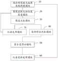
在其中一个实施例中,如图4所示,在读取机器人相机的当前检索图像之前还包括步骤:In one of the embodiments, as shown in FIG. 4 , before reading the current retrieved image of the robot camera, the following steps are further included:
S10:利用激光传感器和机器人相机离线构建混合视觉激光地图;其中,混合视觉激光地图为视觉特征地图的视觉特征与激光平面地图的位姿信息一一对应的地图。S10 : constructing a hybrid vision laser map offline by using a laser sensor and a robot camera; wherein, the hybrid vision laser map is a map in which the visual features of the visual feature map and the pose information of the laser plane map correspond one-to-one.
其中,混合视觉激光地图中包括激光平面地图和视觉特征地图以及激光平面地图中的位姿信息与视觉特征地图中的视觉特征的一一对应关系。具体的,在机器人开始定位前,离线构建激光平面地图、视觉特征地图,并将同一时刻激光平面地图的位姿信息和视觉特征地图的视觉特征进行对应捆绑存储,生成混合视觉激光地图。The hybrid vision laser map includes a laser plane map and a visual feature map, as well as a one-to-one correspondence between the pose information in the laser plane map and the visual features in the visual feature map. Specifically, before the robot starts positioning, the laser plane map and the visual feature map are constructed offline, and the pose information of the laser plane map and the visual features of the visual feature map at the same time are correspondingly bundled and stored to generate a hybrid visual laser map.
在其中一个实施例中,如图5所示,利用激光传感器和机器人相机离线构建混合视觉激光地图的步骤包括:In one embodiment, as shown in FIG. 5 , the step of offline building a hybrid vision laser map by using a laser sensor and a robot camera includes:
S11:获取机器人里程信息;S11: Get the mileage information of the robot;
S12:控制激光传感器对周围环境进行扫描,得到当前扫描数据,同时读取机器人相机的关键帧图像;S12: Control the laser sensor to scan the surrounding environment, obtain the current scan data, and read the key frame image of the robot camera at the same time;
S13:初始化机器人的位置并存储当前扫描数据,根据机器人里程信息得到机器人下一时刻的预测位置,对相邻的两帧扫描数据及机器人里程信息采用定位算法得到机器人的位姿信息;S13: Initialize the position of the robot and store the current scanning data, obtain the predicted position of the robot at the next moment according to the mileage information of the robot, and obtain the pose information of the robot by using a positioning algorithm for two adjacent frames of scanning data and the mileage information of the robot;
S14:控制机器人重复移动,并根据激光传感器采集的扫描数据构建激光平面地图;S14: Control the robot to move repeatedly, and construct a laser plane map according to the scanning data collected by the laser sensor;
S15:提取关键帧图像的视觉特征,获得视觉特征地图,并根据视觉特征与位姿信息联合得到视觉特征地图和激光平面地图一一对应的混合视觉激光地图。S15: Extract the visual features of the key frame images, obtain a visual feature map, and jointly obtain a hybrid visual laser map corresponding to the visual feature map and the laser plane map according to the visual feature and the pose information.
其中,相邻的两帧扫描数据与上述实施例中的解释一样,在此不作赘述。具体的,机器人定位时,读取机器人相机的当前检索图像,并提取当前检索图像的视觉特征,将提取的视觉特征与混合视觉激光地图的视觉特征地图的关键帧视觉特征进行相似度度量,查找当前检索图像中相似度最高的前m帧,并对前m帧进行聚类,并与上一次检索图像对应的聚类类别进行匹配,当检测到新聚类类别时,对当前检索图像和当前检索图像对应的各聚类类别的中心关键帧图像进行局部特征匹配,得到与类别个数相同的多个机器人的当前位姿,进行局部特征匹配后,读取机器人的激光传感器的当前扫描数据,获得当前扫描数据与混合视觉激光地图中的激光平面地图存储的扫描数据的重合度得分,并对各聚类类别的重合度得分进行排序,当检测到得分最高的类别是新聚类类别时,则将该新聚类类别的中心关键帧图像对应的位姿信息更新为机器人的当前位姿。可选的,还可以利用基于图优化的定位与地图构建方法获得机器人的激光平面地图。The scan data of the adjacent two frames are the same as those explained in the above-mentioned embodiment, and are not repeated here. Specifically, when the robot is positioned, the current retrieval image of the robot camera is read, and the visual features of the current retrieval image are extracted. The first m frames with the highest similarity in the current retrieval image are clustered and matched with the cluster category corresponding to the last retrieval image. When a new cluster category is detected, the current retrieval image and the current The central key frame image of each clustering category corresponding to the retrieved image is matched with local features, and the current poses of multiple robots with the same number of categories are obtained. After local feature matching, the current scanning data of the robot's laser sensor is read. Obtain the coincidence score between the current scan data and the scan data stored in the laser plane map in the hybrid vision laser map, and sort the coincidence score of each cluster category. When the category with the highest score is detected as a new cluster category, Then, the pose information corresponding to the central key frame image of the new cluster category is updated to the current pose of the robot. Optionally, a laser plane map of the robot can also be obtained by using a graph optimization-based positioning and map construction method.
在其中一个实施例中,如图6所示,提取关键帧图像的视觉特征的步骤包括:In one embodiment, as shown in FIG. 6 , the step of extracting the visual features of the key frame images includes:
S151:通过Gist全局描述算子提取并存储关键帧图像的视觉特征。S151: Extract and store the visual features of the key frame image through the Gist global description operator.
具体的,在离线构建混合视觉激光地图时,采用Gist全局描述算子提取并存储机器人相机采集的关键帧图像的视觉特征,可以减小存储时所占的存储空间,且采用全局描述算子存储关键帧图像的视觉特征,保证了周围环境中的视觉特征的整体性,有助于提高后期匹配计算效率和匹配的稳定性。Specifically, when constructing a hybrid vision laser map offline, the Gist global description operator is used to extract and store the visual features of the key frame images collected by the robot camera, which can reduce the storage space occupied during storage, and the global description operator is used to store the visual features. The visual features of the key frame images ensure the integrity of the visual features in the surrounding environment, which helps to improve the computational efficiency and stability of matching in the later stage.
在其中一个实施例中,如图7所示,根据局部特征匹配结果获得与类别个数相同的多个机器人的当前位姿的步骤包括步骤:In one of the embodiments, as shown in FIG. 7 , the step of obtaining the current poses of multiple robots with the same number of categories according to the local feature matching result includes the steps:
S42:对匹配内点数超过预设阈值的各聚类类别采用PnP法得到机器人的当前位姿。S42: Using the PnP method to obtain the current pose of the robot for each cluster category whose number of matching points exceeds a preset threshold.
其中,预设阈值是通过实验得到的。PnP算法是指通过多对3D与2D匹配点,在已知或者未知相机内参的情况下,利用最小化重投影误差来求解相机外参的算法。具体的,当检测到当前检索图像的视觉特征和各聚类类别的中心关键帧图像的视觉特征的匹配内点数超过预设阈值时,求解当前检索图像的相机位姿与视觉特征地图相似关键帧图像对应的相机位姿之间的变换,然后得到机器人当前位姿。此时,当前检索图像与混合视觉激光地图中的视觉特征的匹配度较高,利用PnP法计算机器人的当前位姿,即对该聚类类别对应的位姿进行更新,进一步提高定位精度。The preset threshold is obtained through experiments. The PnP algorithm refers to an algorithm that uses multiple pairs of 3D and 2D matching points to solve the camera external parameters by minimizing the reprojection error when the camera internal parameters are known or unknown. Specifically, when it is detected that the number of matching points between the visual feature of the current retrieved image and the visual feature of the central key frame image of each cluster category exceeds a preset threshold, the camera pose of the current retrieved image is found to be similar to the visual feature map of the key frame. The transformation between the camera poses corresponding to the images, and then the current pose of the robot is obtained. At this time, the matching degree between the current retrieval image and the visual features in the hybrid vision laser map is relatively high, and the PnP method is used to calculate the current pose of the robot, that is, the pose corresponding to the cluster category is updated to further improve the positioning accuracy.
在其中一个实施例中,根据局部特征匹配结果获得与类别个数相同的多个机器人的当前位姿的步骤还包括步骤:In one of the embodiments, the step of obtaining the current poses of multiple robots with the same number of categories according to the local feature matching result further includes the steps of:
S43:对匹配内点数未超过预设阈值的各聚类类别,将其对应的中心关键帧图像的位姿作为机器人当前位姿。S43: For each clustering category whose number of matching points does not exceed the preset threshold, use the pose of the corresponding central key frame image as the current pose of the robot.
具体的,当聚类类别匹配内点数没有超过预设阈值时,则对该聚类类别对应的中心关键帧图像的位姿作为机器人当前位姿。此时,当前检索图像与混合视觉激光地图匹配度较低,所以采用该聚类类别对应的中心关键帧图像的位姿作为机器人当前位姿。Specifically, when the number of points in the cluster category matching does not exceed the preset threshold, the pose of the central key frame image corresponding to the cluster category is taken as the current pose of the robot. At this time, the matching degree between the current retrieved image and the hybrid vision laser map is low, so the pose of the central key frame image corresponding to the cluster category is used as the current pose of the robot.
在其中一个实施例中,如图8所示,对前m帧进行多个类别的聚类的步骤包括:In one embodiment, as shown in FIG. 8 , the step of clustering the first m frames of multiple categories includes:
S31:对前m帧的索引采用k-means聚类方法进行k个类别的聚类,得到k个聚类类别的排序;S31: Use the k-means clustering method to perform clustering of k categories on the indices of the first m frames to obtain the ranking of the k cluster categories;
S32:将每个聚类类别的中心值替换该类别关键帧索引的中位数,以落在每个聚类类别的范围内的帧数为基数,乘以机器人的最大速度因子作为该类别的新范围;S32: Replace the center value of each cluster category with the median of the key frame index of the category, take the number of frames falling within the range of each cluster category as the base, and multiply the maximum speed factor of the robot as the category's new range;
S33:将配置新范围的k个聚类类别与上一次检索图像对应的k个聚类类别进行匹配。S33: Match the k cluster categories configured with the new range with the k cluster categories corresponding to the last retrieved image.
其中,k-means聚类方法,是典型的基于原型的目标函数聚类方法的代表,以欧式距离作为相似度度量,是一种基于距离的聚类算法,采用距离作为相似性的评价指标,即认为两个对象的距离越近,其相似度就越大。上一次检索图像等的定义与上述实施例中的相同,在此不做赘述。参数k是通过实验得出的,是根据应用场景等不同,预先设定的。Among them, the k-means clustering method is a representative of the typical prototype-based objective function clustering method. It uses the Euclidean distance as the similarity measure, and is a distance-based clustering algorithm. The distance is used as the similarity evaluation index. That is, it is considered that the closer the distance between two objects, the greater the similarity. The definitions of the last retrieved image and the like are the same as those in the above-mentioned embodiment, and are not repeated here. The parameter k is obtained through experiments and is preset according to different application scenarios.
本发明实施例另一方面还提供一种机器人定位装置,如图9所示,上述机器人定位装置包括:Another aspect of the embodiment of the present invention also provides a robot positioning device. As shown in FIG. 9 , the robot positioning device includes:
图像获取及相似度度量模块20,用于读取机器人相机的当前检索图像,并将当前检索图像与混合视觉激光地图进行相似度度量,查找当前检索图像中相似度最高的前m帧;The image acquisition and
聚类匹配模块30,用于对前m帧进行多个类别的聚类,并将各聚类类别与上一次检索图像对应的聚类类别进行匹配,判断是否产生新聚类类别;The
局部特征匹配模块40,用于若检测到新聚类类别,则对当前检索图像和当前检索图像对应的各聚类类别的中心关键帧图像进行局部特征匹配,并根据局部特征匹配结果获得与类别个数相同的多个机器人的当前位姿;The local
重合度得分模块50,用于读取机器人的激光传感器的当前扫描数据,获得当前扫描数据与混合视觉激光地图的重合度得分,并对各聚类类别的重合度得分进行排序;The
位姿更新发布模块60,用于若检测到得分最高的类别是新聚类类别时,则将该新聚类类别的中心关键帧图像对应的位姿信息更新为机器人的当前位姿。The pose
其中,混合视觉激光地图、参数m、上一次检索图像对应的聚类类别等解释与上述方法实施例中相同,在此不做赘述。The explanations of the hybrid visual laser map, the parameter m, the clustering category corresponding to the last retrieved image, etc. are the same as those in the above method embodiments, and are not repeated here.
具体的,图像获取及相似度度量模块20读取机器人相机的当前检索图像,并将当前检索图像与混合视觉激光地图进行相似度度量,查找当前检索图像中相似度最高的前m帧;聚类匹配模块30对前m帧进行多个类别的聚类,并将各聚类类别与上一次检索图像对应的聚类类别进行匹配;局部特征匹配模块40在检测到新聚类类别时,则对当前检索图像和当前检索图像对应的各聚类类别的中心关键帧图像进行局部特征匹配,并根据局部特征匹配结果获得与类别个数相同的多个机器人的当前位姿;重合度得分模块50读取机器人的激光传感器的当前扫描数据,获得当前扫描数据与激光平面地图的重合度得分,并对各聚类类别的重合度得分进行排序;然后,位姿更新发布模块60在检测到得分最高的类别是新聚类类别时,将该新聚类类别的中心关键帧图像对应的位姿信息更新为机器人的当前位姿。Specifically, the image acquisition and
在其中一个实施例中,如图10所示,机器人定位装置还包括:In one embodiment, as shown in Figure 10, the robot positioning device further includes:
位姿发布模块70,用于在未检测到新聚类类别时,则存储当前的扫描数据,并根据机器人里程信息、相邻的两帧扫描数据和定位算法获得机器人下一时刻的位姿。The
在其中一个实施例中,如图10所示,机器人定位装置还包括:In one embodiment, as shown in Figure 10, the robot positioning device further includes:
混合视觉激光地图离线构建模块10,用于利用激光传感器和机器人相机离线构建混合视觉激光地图;其中,混合视觉激光地图为视觉特征地图的视觉特征与激光平面地图的位姿信息一一对应的地图。The hybrid vision laser map
需要说明的是,本发明机器人定位装置实施例中的各单元模块能够实现上述方法实施例中的方法步骤,在此不做赘述。It should be noted that, each unit module in the embodiment of the robot positioning apparatus of the present invention can implement the method steps in the above method embodiment, which will not be repeated here.
一种计算机设备,包括存储器、处理器及存储在存储器上并可在处理器上运行的计算机程序,处理器执行程序时实现上述机器人定位方法的步骤。A computer device includes a memory, a processor, and a computer program stored in the memory and running on the processor. The processor implements the steps of the above-mentioned robot positioning method when the program is executed.
一种计算机可读存储介质,其上存储有计算机程序,该程序被处理器执行时实现上述机器人定位方法的步骤。A computer-readable storage medium on which a computer program is stored, when the program is executed by a processor, implements the steps of the above-mentioned robot positioning method.
以上所述实施例的各技术特征可以进行任意的组合,为使描述简洁,未对上述实施例中的各个技术特征所有可能的组合都进行描述,然而,只要这些技术特征的组合不存在矛盾,都应当认为是本说明书记载的范围。本领域普通技术人员可以理解实现上述实施例方法中的全部或部分步骤是可以通过程序来指令相关的硬件来完成,所述的程序可以存储于一计算机可读取存储介质中,该程序在执行时,包括以上方法所述的步骤,所述的存储介质,如:ROM/RAM、磁碟、光盘等。The technical features of the above-described embodiments can be combined arbitrarily. For the sake of brevity, all possible combinations of the technical features in the above-described embodiments are not described. However, as long as there is no contradiction between the combinations of these technical features, All should be regarded as the scope described in this specification. Those of ordinary skill in the art can understand that all or part of the steps in the methods of the above embodiments can be completed by instructing the relevant hardware through a program, and the program can be stored in a computer-readable storage medium, and the program can be executed when the program is executed. At the time, it includes the steps described in the above method, and the storage medium, such as: ROM/RAM, magnetic disk, optical disk, etc.
以上所述实施例仅表达了本发明的几种实施方式,其描述较为具体和详细,但并不能因此而理解为对本发明专利范围的限制。应当指出的是,对于本领域的普通技术人员来说,在不脱离本发明构思的前提下,还可以做出若干变形和改进,这些都属于本发明的保护范围。因此,本发明专利的保护范围应以所附权利要求为准。The above-mentioned embodiments only represent several embodiments of the present invention, and the descriptions thereof are specific and detailed, but should not be construed as a limitation on the scope of the patent of the present invention. It should be pointed out that for those of ordinary skill in the art, without departing from the concept of the present invention, several modifications and improvements can also be made, which all belong to the protection scope of the present invention. Therefore, the protection scope of the patent of the present invention should be subject to the appended claims.
Claims (10)
Priority Applications (2)
| Application Number | Priority Date | Filing Date | Title |
|---|---|---|---|
| CN201810041205.2ACN108256574B (en) | 2018-01-16 | 2018-01-16 | Robot positioning method and device |
| PCT/CN2018/077582WO2019140745A1 (en) | 2018-01-16 | 2018-02-28 | Robot positioning method and device |
Applications Claiming Priority (1)
| Application Number | Priority Date | Filing Date | Title |
|---|---|---|---|
| CN201810041205.2ACN108256574B (en) | 2018-01-16 | 2018-01-16 | Robot positioning method and device |
Publications (2)
| Publication Number | Publication Date |
|---|---|
| CN108256574A CN108256574A (en) | 2018-07-06 |
| CN108256574Btrue CN108256574B (en) | 2020-08-11 |
Family
ID=62741434
Family Applications (1)
| Application Number | Title | Priority Date | Filing Date |
|---|---|---|---|
| CN201810041205.2AActiveCN108256574B (en) | 2018-01-16 | 2018-01-16 | Robot positioning method and device |
Country Status (2)
| Country | Link |
|---|---|
| CN (1) | CN108256574B (en) |
| WO (1) | WO2019140745A1 (en) |
Families Citing this family (45)
| Publication number | Priority date | Publication date | Assignee | Title |
|---|---|---|---|---|
| WO2020014864A1 (en)* | 2018-07-17 | 2020-01-23 | 深圳市大疆创新科技有限公司 | Pose determination method and device, and computer readable storage medium |
| JP7002574B2 (en)* | 2018-07-19 | 2022-01-20 | 馭勢科技(北京)有限公司 | Storage and loading methods, devices, systems and storage media for visual self-position estimation maps |
| CN111209353B (en)* | 2018-11-21 | 2024-06-14 | 驭势科技(北京)有限公司 | Visual positioning map loading method, device, system and storage medium |
| CN111381589A (en)* | 2018-12-29 | 2020-07-07 | 沈阳新松机器人自动化股份有限公司 | Robot path planning method |
| CN110189366B (en)* | 2019-04-17 | 2021-07-06 | 北京迈格威科技有限公司 | A laser rough registration method, device, mobile terminal and storage medium |
| CN112393719B (en)* | 2019-08-12 | 2023-04-14 | 科沃斯商用机器人有限公司 | Grid semantic map generation method and device and storage equipment |
| WO2021035669A1 (en)* | 2019-08-30 | 2021-03-04 | 深圳市大疆创新科技有限公司 | Pose prediction method, map construction method, movable platform, and storage medium |
| CN110673608A (en)* | 2019-09-26 | 2020-01-10 | 福建首松智能科技有限公司 | Robot navigation method |
| CN110728721B (en)* | 2019-10-21 | 2022-11-01 | 北京百度网讯科技有限公司 | Method, device and equipment for acquiring external parameters |
| CN110686687B (en)* | 2019-10-31 | 2021-11-09 | 珠海市一微半导体有限公司 | Method for constructing map by visual robot, robot and chip |
| CN111161334B (en)* | 2019-12-31 | 2023-06-02 | 南通大学 | Semantic map construction method based on deep learning |
| CN111060888B (en)* | 2019-12-31 | 2023-04-07 | 芜湖哈特机器人产业技术研究院有限公司 | Mobile robot repositioning method fusing ICP and likelihood domain model |
| CN111222514B (en)* | 2019-12-31 | 2023-06-27 | 上海星思半导体有限责任公司 | A local map optimization method based on visual localization |
| CN111223145A (en)* | 2020-01-03 | 2020-06-02 | 上海有个机器人有限公司 | Data processing method, system, service device and storage medium thereof |
| CN111275763B (en)* | 2020-01-20 | 2023-10-13 | 深圳市普渡科技有限公司 | Closed loop detection system, multi-sensor fusion SLAM system and robot |
| CN113256715B (en)* | 2020-02-12 | 2024-04-05 | 北京京东乾石科技有限公司 | Positioning method and device for robot |
| CN111337943B (en)* | 2020-02-26 | 2022-04-05 | 同济大学 | A mobile robot localization method based on vision-guided laser relocation |
| CN111444853B (en)* | 2020-03-27 | 2023-04-07 | 长安大学 | Loop detection method of visual SLAM |
| CN111461141B (en)* | 2020-03-30 | 2023-08-29 | 歌尔科技有限公司 | Equipment pose calculating method and device |
| CN111538855B (en)* | 2020-04-29 | 2024-03-08 | 浙江商汤科技开发有限公司 | Visual positioning method and device, electronic equipment and storage medium |
| CN113672756B (en)* | 2020-05-14 | 2025-08-12 | 华为技术有限公司 | Visual positioning method and electronic equipment |
| CN113739785B (en)* | 2020-05-29 | 2024-09-13 | 杭州海康机器人股份有限公司 | Robot positioning method, device and storage medium |
| CN111780744B (en)* | 2020-06-24 | 2023-12-29 | 浙江华睿科技股份有限公司 | Mobile robot hybrid navigation method, equipment and storage device |
| CN111862214B (en)* | 2020-07-29 | 2023-08-25 | 上海高仙自动化科技发展有限公司 | Computer equipment positioning method, device, computer equipment and storage medium |
| CN111986313B (en)* | 2020-08-21 | 2024-09-17 | 浙江商汤科技开发有限公司 | Loop detection method and device, electronic equipment and storage medium |
| CN114199243B (en)* | 2020-09-18 | 2024-05-24 | 浙江舜宇智能光学技术有限公司 | Pose estimation and motion planning method and device for robot and robot |
| CN114415648B (en)* | 2020-10-10 | 2025-04-04 | 杭州海康威视数字技术股份有限公司 | Method, device and apparatus for determining ground plane |
| CN112162294B (en)* | 2020-10-10 | 2023-12-15 | 北京布科思科技有限公司 | Robot structure detection method based on laser sensor |
| CN112596064B (en)* | 2020-11-30 | 2024-03-08 | 中科院软件研究所南京软件技术研究院 | Integrated global positioning method for indoor robots integrating laser and vision |
| CN113189613B (en)* | 2021-01-25 | 2023-01-10 | 广东工业大学 | Robot positioning method based on particle filtering |
| CN112965076B (en)* | 2021-01-28 | 2024-05-24 | 上海思岚科技有限公司 | Multi-radar positioning system and method for robot |
| CN112802102A (en)* | 2021-02-01 | 2021-05-14 | 深圳万拓科技创新有限公司 | Pose repositioning method, device, equipment and medium of laser sweeper |
| CN113031588B (en)* | 2021-02-02 | 2023-11-07 | 广东柔乐电器有限公司 | Mall robot navigation system |
| CN112966616B (en)* | 2021-03-11 | 2024-06-14 | 深圳市无限动力发展有限公司 | Visual repositioning method, device, equipment and medium based on clustering |
| CN113011359B (en)* | 2021-03-26 | 2023-10-24 | 浙江大学 | Method for simultaneously detecting plane structure and generating plane description based on image and application |
| CN113011517B (en)* | 2021-03-30 | 2024-09-17 | 上海商汤临港智能科技有限公司 | Positioning result detection method and device, electronic equipment and storage medium |
| CN113010724A (en)* | 2021-04-29 | 2021-06-22 | 山东新一代信息产业技术研究院有限公司 | Robot map selection method and system based on visual feature point matching |
| CN113269803B (en)* | 2021-06-09 | 2023-01-13 | 中国科学院自动化研究所 | Scanning positioning method, system and equipment based on 2D laser and depth image fusion |
| CN113777615B (en)* | 2021-07-19 | 2024-03-29 | 派特纳(上海)机器人科技有限公司 | Positioning method and system of indoor robot and cleaning robot |
| CN115657001A (en)* | 2022-10-27 | 2023-01-31 | 南方电网调峰调频发电有限公司储能科研院 | Underwater tunnel robot positioning method based on multiple sensors |
| CN115508843B (en)* | 2022-10-28 | 2025-07-29 | 苏州大学 | Positioning method of sweeping robot |
| CN116680431B (en)* | 2022-11-29 | 2024-09-06 | 荣耀终端有限公司 | A visual positioning method, electronic equipment, medium and product |
| CN117115238B (en)* | 2023-04-12 | 2024-06-25 | 荣耀终端有限公司 | Method for determining posture, electronic device and storage medium |
| CN118362113B (en)* | 2024-04-23 | 2025-02-21 | 深圳市蓝色极光储能科技有限公司 | Mobile robot-based mapping method and system |
| CN119024351B (en)* | 2024-08-30 | 2025-08-12 | 深圳可立点科技有限公司 | A global positioning method and device |
Citations (3)
| Publication number | Priority date | Publication date | Assignee | Title |
|---|---|---|---|---|
| US7043055B1 (en)* | 1999-10-29 | 2006-05-09 | Cognex Corporation | Method and apparatus for locating objects using universal alignment targets |
| CN101920498A (en)* | 2009-06-16 | 2010-12-22 | 泰怡凯电器(苏州)有限公司 | Device and robot for simultaneous localization and map creation of indoor service robots |
| CN105866782A (en)* | 2016-04-04 | 2016-08-17 | 上海大学 | Moving target detection system based on laser radar and moving target detection method thereof |
Family Cites Families (6)
| Publication number | Priority date | Publication date | Assignee | Title |
|---|---|---|---|---|
| KR100955483B1 (en)* | 2008-08-12 | 2010-04-30 | 삼성전자주식회사 | 3D grid map making method and control method of automatic driving device using same |
| US9037396B2 (en)* | 2013-05-23 | 2015-05-19 | Irobot Corporation | Simultaneous localization and mapping for a mobile robot |
| JP6475772B2 (en)* | 2016-05-09 | 2019-02-27 | ツーアンツ インク.TwoAntz Inc. | Navigation device and method by visual positioning |
| CN106153048A (en)* | 2016-08-11 | 2016-11-23 | 广东技术师范学院 | A kind of robot chamber inner position based on multisensor and Mapping System |
| CN106092104B (en)* | 2016-08-26 | 2019-03-15 | 深圳微服机器人科技有限公司 | A kind of method for relocating and device of Indoor Robot |
| CN106940186B (en)* | 2017-02-16 | 2019-09-24 | 华中科技大学 | A kind of robot autonomous localization and navigation methods and systems |
- 2018
- 2018-01-16CNCN201810041205.2Apatent/CN108256574B/enactiveActive
- 2018-02-28WOPCT/CN2018/077582patent/WO2019140745A1/ennot_activeCeased
Patent Citations (3)
| Publication number | Priority date | Publication date | Assignee | Title |
|---|---|---|---|---|
| US7043055B1 (en)* | 1999-10-29 | 2006-05-09 | Cognex Corporation | Method and apparatus for locating objects using universal alignment targets |
| CN101920498A (en)* | 2009-06-16 | 2010-12-22 | 泰怡凯电器(苏州)有限公司 | Device and robot for simultaneous localization and map creation of indoor service robots |
| CN105866782A (en)* | 2016-04-04 | 2016-08-17 | 上海大学 | Moving target detection system based on laser radar and moving target detection method thereof |
Also Published As
| Publication number | Publication date |
|---|---|
| CN108256574A (en) | 2018-07-06 |
| WO2019140745A1 (en) | 2019-07-25 |
Similar Documents
| Publication | Publication Date | Title |
|---|---|---|
| CN108256574B (en) | Robot positioning method and device | |
| Sock et al. | Multi-view 6D object pose estimation and camera motion planning using RGBD images | |
| Humenberger et al. | Investigating the role of image retrieval for visual localization: An exhaustive benchmark | |
| US8798357B2 (en) | Image-based localization | |
| CN111323024B (en) | Positioning method and device, equipment, storage medium | |
| CN111489393A (en) | VS L AM method, controller and mobile device | |
| CN109145969B (en) | Method, device, equipment and medium for processing point cloud data of three-dimensional object | |
| JP2016018538A (en) | Image recognition apparatus, method, and program | |
| JP2010176380A (en) | Information processing device and method, program, and recording medium | |
| JP7370759B2 (en) | Image processing device, image processing method and program | |
| CN114612786B (en) | Obstacle detection method, mobile robot and machine-readable storage medium | |
| Krajník et al. | Image features and seasons revisited | |
| CN114556425A (en) | Positioning method, positioning device, unmanned aerial vehicle and storage medium | |
| CN117557901A (en) | Detection model of small target crops in field and construction method | |
| Fan et al. | Visual localization using semantic segmentation and depth prediction | |
| JP5305031B2 (en) | Feature amount extraction apparatus and method, and position estimation apparatus and method | |
| JP2017010549A (en) | Method and apparatus for data retrieval in a light field database | |
| KR20220055072A (en) | Method for indoor localization using deep learning | |
| CN112528078A (en) | Image filing method, device and equipment | |
| Liu et al. | Deep learning of directional truncated signed distance function for robust 3D object recognition | |
| CN115063760A (en) | Vehicle travelable area detection method, device, equipment and storage medium | |
| WO2025016260A1 (en) | Image processing method and apparatus, and device, storage medium and program product | |
| CN117078757B (en) | An RGB-D SLAM method for dynamic environments | |
| Sinha et al. | Image retrieval using landmark indexing for indoor navigation | |
| CN105447887A (en) | Historical-route-based target tracking method and electronic equipment |
Legal Events
| Date | Code | Title | Description |
|---|---|---|---|
| PB01 | Publication | ||
| PB01 | Publication | ||
| SE01 | Entry into force of request for substantive examination | ||
| SE01 | Entry into force of request for substantive examination | ||
| GR01 | Patent grant | ||
| GR01 | Patent grant | ||
| CP01 | Change in the name or title of a patent holder | Address after:510070 15 building, 100 martyrs Road, Yuexiu District, Guangzhou, Guangdong. Patentee after:Institute of intelligent manufacturing, Guangdong Academy of Sciences Address before:510070 15 building, 100 martyrs Road, Yuexiu District, Guangzhou, Guangdong. Patentee before:GUANGDONG INSTITUTE OF INTELLIGENT MANUFACTURING | |
| CP01 | Change in the name or title of a patent holder |