CN108229416B - Robot SLAM method based on semantic segmentation technology - Google Patents
Robot SLAM method based on semantic segmentation technologyDownload PDFInfo
- Publication number
- CN108229416B CN108229416BCN201810046213.6ACN201810046213ACN108229416BCN 108229416 BCN108229416 BCN 108229416BCN 201810046213 ACN201810046213 ACN 201810046213ACN 108229416 BCN108229416 BCN 108229416B
- Authority
- CN
- China
- Prior art keywords
- semantic segmentation
- plane
- image
- plane area
- feature points
- Prior art date
- Legal status (The legal status is an assumption and is not a legal conclusion. Google has not performed a legal analysis and makes no representation as to the accuracy of the status listed.)
- Expired - Fee Related
Links
Images
Classifications
- G—PHYSICS
- G06—COMPUTING OR CALCULATING; COUNTING
- G06V—IMAGE OR VIDEO RECOGNITION OR UNDERSTANDING
- G06V20/00—Scenes; Scene-specific elements
- G06V20/10—Terrestrial scenes
- G—PHYSICS
- G06—COMPUTING OR CALCULATING; COUNTING
- G06F—ELECTRIC DIGITAL DATA PROCESSING
- G06F18/00—Pattern recognition
- G06F18/20—Analysing
- G06F18/24—Classification techniques
- G—PHYSICS
- G06—COMPUTING OR CALCULATING; COUNTING
- G06V—IMAGE OR VIDEO RECOGNITION OR UNDERSTANDING
- G06V10/00—Arrangements for image or video recognition or understanding
- G06V10/20—Image preprocessing
- G06V10/26—Segmentation of patterns in the image field; Cutting or merging of image elements to establish the pattern region, e.g. clustering-based techniques; Detection of occlusion
- G06V10/267—Segmentation of patterns in the image field; Cutting or merging of image elements to establish the pattern region, e.g. clustering-based techniques; Detection of occlusion by performing operations on regions, e.g. growing, shrinking or watersheds
- G—PHYSICS
- G06—COMPUTING OR CALCULATING; COUNTING
- G06V—IMAGE OR VIDEO RECOGNITION OR UNDERSTANDING
- G06V10/00—Arrangements for image or video recognition or understanding
- G06V10/40—Extraction of image or video features
- G06V10/46—Descriptors for shape, contour or point-related descriptors, e.g. scale invariant feature transform [SIFT] or bags of words [BoW]; Salient regional features
- G06V10/462—Salient features, e.g. scale invariant feature transforms [SIFT]
Landscapes
- Engineering & Computer Science (AREA)
- Theoretical Computer Science (AREA)
- Physics & Mathematics (AREA)
- General Physics & Mathematics (AREA)
- Multimedia (AREA)
- Data Mining & Analysis (AREA)
- Computer Vision & Pattern Recognition (AREA)
- Bioinformatics & Cheminformatics (AREA)
- Evolutionary Computation (AREA)
- Evolutionary Biology (AREA)
- General Engineering & Computer Science (AREA)
- Bioinformatics & Computational Biology (AREA)
- Artificial Intelligence (AREA)
- Life Sciences & Earth Sciences (AREA)
- Image Analysis (AREA)
- Image Processing (AREA)
Abstract
Description
Translated fromChinese技术领域technical field
本发明涉及机器人导航技术领域,特别涉及一种基于语义分割技术的机器人SLAM方法。The invention relates to the technical field of robot navigation, in particular to a robot SLAM method based on semantic segmentation technology.
背景技术Background technique
对于机器人视觉导航问题,主要研究从多幅图像帧(2幅及以上图像)中恢复场景的三维结构以及拍摄各图像帧的摄像机所对应的位置和姿态。在机器人导航领域中一般称为Simultaneous Localization and Mapping(即时定位与地图构建,SLAM),一般情况下场景的三维结构用无序的点云方式表达。For the problem of robot vision navigation, the main research is to recover the three-dimensional structure of the scene from multiple image frames (two or more images) and the position and attitude of the camera that captures each image frame. In the field of robot navigation, it is generally called Simultaneous Localization and Mapping (Simultaneous Localization and Map Construction, SLAM). Generally, the three-dimensional structure of the scene is expressed in the form of disordered point cloud.
早期的SLAM方法基于矩阵分解技术。这类方法首先将观测匹配得到的特征点图像坐标构成一个矩阵,通过SVD分解技术得到特征点的三维坐标以及摄像机的位姿参数。20世纪90年代末,计算机视觉研究人员从摄影测量学领域引入了光束法平差技术(BundleAdjustment),该方法通过最小二乘优化三维场景点在各图像帧中的投影以及该点观测位置之间的欧氏距离实现同时场景点三维结构估计以及摄像机位姿参数计算。由于待优化的未知变量个数正比于三维场景点以及图像帧数,当图像序列规模较大时,光束法平差算法复杂度非常高,从而限制了该类方法在大规模环境下的应用。Early SLAM methods were based on matrix factorization techniques. This kind of method first forms a matrix of the feature point image coordinates obtained by observation and matching, and obtains the three-dimensional coordinates of the feature point and the pose parameters of the camera through the SVD decomposition technology. In the late 1990s, computer vision researchers introduced the Bundle Adjustment technique from the field of photogrammetry, which optimized the projection of a 3D scene point in each image frame and the observation position of the point by least squares. The Euclidean distance achieves simultaneous scene point 3D structure estimation and camera pose parameter calculation. Since the number of unknown variables to be optimized is proportional to the number of 3D scene points and the number of image frames, when the image sequence is large, the complexity of the beam method adjustment algorithm is very high, which limits the application of this method in large-scale environments.
现有的SLAM算法主要通过分析图像帧中的特征点实现,从而导致最终的输出结果是离散的三维点云,然而在诸如机器人抓握操纵物体和机器人自主导航(障碍物规避、路径规划等)等领域,需要知道场景的结构以及语义信息,仅仅提供三维点云是不够的,从而限制了SLAM的应用范围。此外基于特征点的方法一般需要图像中纹理相对丰富,对于光滑单调的场景,基于特征点的SLAM方法就无能为力了。Existing SLAM algorithms are mainly implemented by analyzing the feature points in the image frame, resulting in the final output being a discrete 3D point cloud. However, in applications such as robot grasping and manipulating objects and robot autonomous navigation (obstacle avoidance, path planning, etc.) In other fields, it is necessary to know the structure and semantic information of the scene, and only providing 3D point clouds is not enough, thus limiting the application scope of SLAM. In addition, the method based on feature points generally requires relatively rich texture in the image. For smooth and monotonous scenes, the SLAM method based on feature points is powerless.
发明内容SUMMARY OF THE INVENTION
本发明提供一种基于语义分割技术的机器人SLAM方法,以解决现有技术中存在的上述技术问题。The present invention provides a robot SLAM method based on semantic segmentation technology to solve the above technical problems existing in the prior art.
为解决上述技术问题,本发明提供一种基于语义分割技术的机器人SLAM方法,包括:In order to solve the above technical problems, the present invention provides a robot SLAM method based on semantic segmentation technology, including:
步骤1:获取机器人运动过程中拍摄的图像数据,该图像数据为单目摄像机拍摄的视频序列;Step 1: Acquire image data captured during the movement of the robot, where the image data is a video sequence captured by a monocular camera;
步骤2:对图像数据进行语义分割处理,从而区分得到图像中的平面区域和非平面区域,检测非平面区域中的特征点;Step 2: Semantic segmentation is performed on the image data, thereby distinguishing the planar area and the non-planar area in the image, and detecting the feature points in the non-planar area;
步骤3:构建所述特征点和平面区域的外观描述方式,从而建立特征点和平面区域在不同图像帧之间的匹配对应关系;Step 3: construct the appearance description mode of the feature points and the plane area, so as to establish the matching correspondence between the feature points and the plane area between different image frames;
步骤4:根据上述对应关系,构建一个似然函数;Step 4: According to the above correspondence, construct a likelihood function;
步骤5:最小化所述似然函数得到混合三维地图和相机运动参数。Step 5: Minimize the likelihood function to obtain a hybrid 3D map and camera motion parameters.
作为优选,所述步骤2中:采用深度学习中的SegNet来实现对图像数据的语义分割,利用SIFT算法检测非平面区域中的特征点。Preferably, in the step 2: SegNet in deep learning is used to implement semantic segmentation of image data, and SIFT algorithm is used to detect feature points in non-planar areas.
作为优选,所述步骤3中:采用SIFT特征描述算法作为特征点的外观描述矢量。Preferably, in the step 3: the SIFT feature description algorithm is used as the appearance description vector of the feature points.
作为优选,利用K-d树算法匹配外观描述矢量得到不同图像中特征点之间的对应关系。Preferably, the K-d tree algorithm is used to match the appearance description vectors to obtain the correspondence between the feature points in different images.
作为优选,所述步骤3中:采用颜色直方图和纹理特征作为平面区域的描述方式,其中,所述颜色直方图通过将图像中平面区域内所有像素转换到HSV色彩空间后构建H和S通道的二维直方图实现,纹理特征通过计算区域内像素的Laws纹理能量描述特征矢量表示;最后将颜色直方图构成的矢量和纹理特征矢量组合在一起构成平面区域的外观描述矢量。Preferably, in the step 3: the color histogram and texture features are used as the description method of the plane area, wherein the color histogram constructs H and S channels by converting all pixels in the plane area in the image to the HSV color space The texture feature is represented by the Laws texture energy description feature vector of the pixels in the calculation area; finally, the vector composed of the color histogram and the texture feature vector are combined to form the appearance description vector of the plane region.
作为优选,通过对语义分割结果进行特征计算和边缘统计得到平面区域的外观描述方式,通过特征矢量最近邻匹配结合极线约束来获得平面区域在不同图像帧之间的匹配对应关系。Preferably, the appearance description mode of the plane region is obtained by performing feature calculation and edge statistics on the semantic segmentation result, and the matching correspondence between the plane regions between different image frames is obtained by the feature vector nearest neighbor matching combined with the epipolar constraint.
作为优选,所述步骤4包括:通过因子图表达步骤3中的对应关系,根据所述因子图构建相应的似然函数。Preferably, the step 4 includes: expressing the corresponding relationship in the step 3 through a factor graph, and constructing a corresponding likelihood function according to the factor graph.
作为优选,所述步骤5包括:对所述似然函数取负对数得到代价函数,对所述代价函数进行模拟退火结合梯度下降策略实现最小化,进而获得相机位置姿态参数、三维空间点以及平面参数信息。Preferably, the step 5 includes: taking the negative logarithm of the likelihood function to obtain a cost function, and performing simulated annealing on the cost function combined with a gradient descent strategy to achieve minimization, and then obtaining camera position and attitude parameters, three-dimensional space points and Plane parameter information.
作为优选,所述因子图还同时表达:三维空间中的特征点和平面区域之间的相互作用关系与在二维的图像中的相互作用关系一致。Preferably, the factor graph also expresses: the interaction relationship between the feature points and the plane region in the three-dimensional space is consistent with the interaction relationship in the two-dimensional image.
作为优选,所述步骤5中:混合三维地图通过三维空间的点以及平面来表示,其中,三维空间的平面包含语义信息。Preferably, in the step 5: the hybrid three-dimensional map is represented by points and planes in the three-dimensional space, wherein the planes in the three-dimensional space contain semantic information.
与现有技术相比,本发明的基于语义分割技术的机器人SLAM方法,利用语义分割技术对图像中平面区域和非平面区域进行区分,并检测非平面区域的特征点,当图像中难以提取特征点或特征点较少时,能够通过平面区域匹配提升定位和场景重建的稳定性;构建得到的三维混合地图中包含部分语义信息,如地面、墙面等,这类信息有助于其他模块的处理,如机器人可通行区域分析、行人检测等。Compared with the prior art, the robot SLAM method based on the semantic segmentation technology of the present invention uses the semantic segmentation technology to distinguish the planar area and the non-planar area in the image, and detects the feature points of the non-planar area, when it is difficult to extract features in the image. When there are few points or feature points, the stability of positioning and scene reconstruction can be improved by plane area matching; the constructed 3D hybrid map contains some semantic information, such as ground, wall, etc., which is helpful for other modules. Processing, such as robot passable area analysis, pedestrian detection, etc.
附图说明Description of drawings
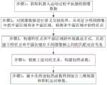
图1为本发明基于语义分割技术的机器人SLAM方法流程图;Fig. 1 is the flow chart of the robot SLAM method based on semantic segmentation technology of the present invention;
图2为本发明一具体实施方式中构建的因子图。Figure 2 is a factor graph constructed in a specific embodiment of the present invention.
具体实施方式Detailed ways
为使本发明的上述目的、特征和优点能够更加明显易懂,下面结合附图对本发明的具体实施方式做详细的说明。需说明的是,本发明附图均采用简化的形式且均使用非精准的比例,仅用以方便、明晰地辅助说明本发明实施例的目的。In order to make the above objects, features and advantages of the present invention more clearly understood, the specific embodiments of the present invention will be described in detail below with reference to the accompanying drawings. It should be noted that the accompanying drawings of the present invention are all in a simplified form and use inaccurate scales, and are only used to facilitate and clearly assist the purpose of explaining the embodiments of the present invention.
如图1所示,本发明提供一种基于语义分割技术的机器人SLAM方法,通过对单目摄像机拍摄的视频序列进行处理,来获得相机运动参数并同时构建环境混合三维地图。其具体包括以下:As shown in FIG. 1 , the present invention provides a robot SLAM method based on semantic segmentation technology, which obtains camera motion parameters and simultaneously constructs a mixed three-dimensional map of the environment by processing a video sequence captured by a monocular camera. It specifically includes the following:
步骤1:获取机器人运动过程中拍摄的图像数据,该图像数据为单目摄像机拍摄的视频序列。Step 1: Acquire image data captured during the movement of the robot, where the image data is a video sequence captured by a monocular camera.
步骤2:采用深度学习中的SegNet(语义分割算法)对图像数据进行语义分割处理,从而区分得到图像中的平面区域和非平面区域,利用SIFT(尺度不变特征转换)算法检测非平面区域中的特征点。Step 2: Use SegNet (Semantic Segmentation Algorithm) in deep learning to perform semantic segmentation on the image data, so as to distinguish the plane area and non-planar area in the image, and use the SIFT (Scale Invariant Feature Transformation) algorithm to detect the non-planar area. feature points.
步骤3:构建所述特征点和平面区域的外观描述方式,从而建立特征点和平面区域在不同图像帧之间的匹配对应关系。具体地,采用SIFT特征描述算法作为特征点的外观描述矢量。采用颜色直方图和纹理特征作为平面区域的描述方式,其中,所述颜色直方图通过将图像中平面区域内所有像素转换到HSV色彩空间后构建H和S通道的二维直方图实现,纹理特征通过计算区域内像素的Laws纹理能量描述特征矢量表示;最后将颜色直方图构成的矢量和纹理特征矢量组合在一起构成平面区域的外观描述矢量。进一步的,利用K-d树(k-维树)算法匹配外观描述矢量得到不同图像中特征点之间的对应关系;通过对语义分割结果进行特征计算和边缘统计得到平面区域的外观描述方式,通过特征矢量最近邻匹配结合极线约束来获得平面区域在不同图像帧之间的匹配对应关系。Step 3: Construct the appearance description mode of the feature points and the plane area, so as to establish the matching correspondence between the feature points and the plane area in different image frames. Specifically, the SIFT feature description algorithm is used as the appearance description vector of the feature points. The color histogram and texture features are used as the description method of the plane area, wherein the color histogram is realized by converting all pixels in the plane area in the image to the HSV color space and then constructing a two-dimensional histogram of the H and S channels. The feature vector representation is described by calculating the Laws texture energy of the pixels in the area; finally, the vector composed of the color histogram and the texture feature vector are combined to form the appearance description vector of the plane area. Further, the K-d tree (k-dimensional tree) algorithm is used to match the appearance description vectors to obtain the correspondence between the feature points in different images; the appearance description method of the plane region is obtained by performing feature calculation and edge statistics on the semantic segmentation results, and the features Vector nearest-neighbor matching combines epipolar constraints to obtain the matching correspondence between plane regions in different image frames.
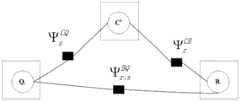
步骤4:根据上述对应关系,构建一个似然函数;具体地,通过因子图表达步骤3中的对应关系,根据所述因子图构建相应的似然函数。其中,所述因子图还同时表达:三维空间中的特征点和平面区域之间的相互作用关系与在二维的图像中的相互作用关系一致。Step 4: Construct a likelihood function according to the above-mentioned correspondence; specifically, express the correspondence in step 3 through a factor graph, and construct a corresponding likelihood function according to the factor graph. Wherein, the factor graph also expresses: the interaction relationship between the feature points and the plane region in the three-dimensional space is consistent with the interaction relationship in the two-dimensional image.
步骤5:最小化所述似然函数得到混合三维地图和相机运动参数。对所述似然函数取负对数得到代价函数,对所述代价函数进行模拟退火结合梯度下降策略实现最小化,进而获得相机位置姿态参数、三维空间点以及平面参数信息。Step 5: Minimize the likelihood function to obtain a hybrid 3D map and camera motion parameters. The cost function is obtained by taking the negative logarithm of the likelihood function, and the cost function is minimized by simulated annealing combined with the gradient descent strategy, and then the camera position and attitude parameters, three-dimensional space points and plane parameter information are obtained.
作为优选,所述步骤5中:混合三维地图通过三维空间的点以及平面来表示,其中,三维空间的平面包含语义信息。Preferably, in the step 5: the hybrid three-dimensional map is represented by points and planes in the three-dimensional space, wherein the planes in the three-dimensional space contain semantic information.
继续参照图1,下面举例具体说明本发明的SLAM方法的操作步骤:Continue to refer to Fig. 1, the operation steps of the SLAM method of the present invention are described in detail below with an example:
首先,步骤1:获取机器人运动过程中拍摄的图像数据。First, Step 1: Obtain image data captured during robot motion.
所述图像数据为单目摄像机拍摄的视频序列,即为一组机器人在运动过程中拍摄的图像数据集合I={I1,...,Ik,...,IN},其中Ik是第k幅输入图像。The image data is a video sequence captured by a monocular camera, that is, a set of image data I= {I1 ,...,Ik ,...,IN } captured by a group of robots during motion, where Ik is the kth input image.
进一步的,所述步骤1还包括获取拍摄过程中的相机参数,该相机参数包括:已知相机内参数信息矩阵集合K和未知的相机外参数信息集合C,其中,K={Kk}为拍摄第k幅输入图像Ik时摄像机的内参数,C={Ck},Ck={Rk,Tk}为拍摄第k幅输入图像Ik时摄像机相对位姿参数。Further, the step 1 further includes acquiring the camera parameters during the shooting process, the camera parameters include: a known camera internal parameter information matrix set K and an unknown camera external parameter information set C, where K={Kk } is The internal parameters of the camera when shooting the k-th input image Ik , C={Ck }, Ck ={Rk , Tk } are the relative pose parameters of the camera when shooting the k-th input image Ik .
接着,执行步骤2和3:采用深度学习中的SegNet对图像数据进行语义分割处理,选择符合平面语义信息的区域如地面和房屋外墙立面,进行图像帧间匹配,得到平面区域,平面区域以外的其他区域作为非平面区域,利用SIFT算法检测非平面区域中的特征点。接着,构建所述特征点和平面区域的外观描述方式,从而建立特征点和平面区域在不同图像帧之间的匹配对应关系。Then, perform steps 2 and 3: use SegNet in deep learning to perform semantic segmentation processing on image data, select areas that conform to the semantic information of the plane, such as the ground and the facade of the outer wall of the house, perform inter-image matching, and obtain the plane area, the plane area The other regions are regarded as non-planar regions, and the SIFT algorithm is used to detect the feature points in the non-planar regions. Next, an appearance description mode of the feature points and the plane region is constructed, so as to establish the matching correspondence between the feature points and the plane region in different image frames.
具体地,对于平面区域:令图像中的平面区域所对应的三维空间平面集合为B={Br},其中每个三维空间平面Br的表达方式为Br=(Xr,Yr,Zr,nr,sr,cr)。(Xr,Yr,Zr)为三维空间平面的中心坐标;nr为三维空间平面的法向量;sr为三维空间平面的面积;cr为三维空间平面的语义类别。其中,B是未知的待估计参数。Specifically, for the plane area: let the set of three-dimensional space planes corresponding to the plane area in the image be B={Br }, wherein the expression of each three-dimensional space plane Br is Br =(Xr , Yr ,Zr , nr,sr ,cr) . (Xr , Yr , Zr ) are the center coordinates of the three-dimensional space plane; nr is the normal vector of the three-dimensional space plane; sr is the area of the three-dimensional space plane;cr is the semantic category of the three-dimensional space plane. where B is the unknown parameter to be estimated.
本发明还定义三维空间平面和二维图像中平面的映射关系集合


定义集合B与集合b之间的对应关系集合g,g={gr},其中gr={l1,l2,...}表示三维空间平面Br分别和
对于特征点:定义地图中所有三维特征点坐标的集合Q,Q={Qs},地图中第s个三维特征点Qs的表示方式为Qs=(Xs,Ys,Zs),从而描述了特征点在世界坐标系下的三维坐标,本实施例中,集合Q是未知的待估计参数。For feature points: define the set Q of all three-dimensional feature point coordinates in the map, Q={Qs }, the representation of the s-th three-dimensional feature point Qs in the map is Qs =(Xs ,Ys ,Zs ) , thereby describing the three-dimensional coordinates of the feature points in the world coordinate system. In this embodiment, the set Q is an unknown parameter to be estimated.
进一步的,定义三维特征点和二维图像点之间的映射关系集合

进一步的,定义集合Q与集合q之间的对应关系集合u={us},其中us={i1,i2,...}表示三维点Qs分别和
接着,执行步骤4,根据上述对应关系,构建一个似然函数。Next, step 4 is performed to construct a likelihood function according to the above corresponding relationship.
需要说明的是,本发明中蕴含两个原理:其中一个原理为上述的对应关系,也即是说:三维空间中的特征点和平面区域与它们在图像中的投影点或投影区域对应;第二个原理为:三维空间中的特征点和平面区域之间的相互作用关系与在二维的图像中的相互作用关系一致,其中,二维的图像中特征点和平面区域的相互作用关系为通过机器学习习得的结果。将上述两个原理转化为如图2所示的因子图,图中,


根据所述因子图构建如下的似然函数,以求解所需变量:From the factor graph, construct the following likelihood function to solve for the desired variables:

接着执行步骤5,由于上式中包含乘积项,难以直接进行优化,因此本发明在实际操作过程中对该似然函数取负对数得到如下代价函数:Then perform step 5, because the above formula contains the product term, it is difficult to directly optimize, so the present invention takes the negative logarithm of the likelihood function in the actual operation process to obtain the following cost function:

其中,


具体地,为了获得

其中,Nc是相机图像数,σq为二维图像中投影测量误差的方差,
为了获得


对于三维空间平面区域的面积,首先根据(Xr,Yr,Zr)和Ck计算平面和相机之间的距离


对于平面的语义类别cr,则直接利用SegNet的输出进行初始化,并记录其相应的置信度P(cr=c)。For the plane semantic category cr, the output ofSegNet is directly used for initialization, and its corresponding confidence P (cr =c) is recorded.


其中,

其中Nsc是语义类别的种数,


其中,

为了获得


其中,ds,r为点Qs到平面Br之间的距离。Among them, ds, r is the distance between the point Qs and the plane Br .
如此,便明确了代价函数即式(1)中各项的含义。最后,对代价函数进行模拟退火结合梯度下降策略,从而实现最小化,获得最终所需的结果,其主要步骤如下:In this way, the cost function, that is, the meaning of each item in equation (1), is clarified. Finally, the simulated annealing of the cost function is combined with the gradient descent strategy to achieve minimization and obtain the final desired result. The main steps are as follows:
步骤100:初始化相机外参数信息集合C,并且令C0=C。此步骤相机外参数信息初始化可以通过传统的基于两相邻图像帧匹配特征点后计算本质矩阵E并对其进行SVD(奇异值)分解得到。并且按上述方法得到初始化的Q0=Q和B0=B。Step 100: Initialize a set C of out-of-camera parameter information, and let C0 =C. In this step, the camera extrinsic parameter information initialization can be obtained by traditionally matching the feature points based on two adjacent image frames and then calculating the essential matrix E and performing SVD (singular value) decomposition on it. And the initialized Q0 =Q and B0 =B are obtained as above.
步骤200:将下述步骤迭代运行M次。其中M为预先设定好的值,取决于结果要求精度和硬件的运算性能。当精度要求高或硬件的运算能力强时,可以适当增加M值,一般可取M=50。假设当前为第i次迭代。Step 200: Iteratively run the following steps M times. Among them, M is a preset value, which depends on the required precision of the result and the computing performance of the hardware. When the precision requirement is high or the computing power of the hardware is strong, the M value can be appropriately increased, and M=50 is generally desirable. Suppose the current is the ith iteration.
步骤201:对相机外参数信息集合C进行扰动,即C′i=Ci-1+C',其中C'为高斯分布的高维矢量。Step 201: Perturbing the set C of extrinsic parameter information of the camera, that is, C′i =Ci-1 +C′, where C′ is a high-dimensional vector of Gaussian distribution.
步骤202:固定C′i,对式(1)-log(ψ(Q,B,C|I))分别对Q,B求偏导数,以Qi-1,Bi-1为初始值,通过梯度下降法最小化-log(ψ(Q,B,C|I)),得到优化后的Qi和Bi。Step 202: Fix C′i , calculate partial derivatives with respect to Q and B respectively for formula (1)-log(ψ(Q,B,C|I)), take Qi-1 and Bi-1 as initial values, Minimize -log(ψ(Q,B,C|I)) by gradient descent to get the optimized Qi and Bi.
步骤203:固定Qi和Bi,对式(1)-log(ψ(Q,B,C|I))求相对C求偏导数,以Ci'为初始值,通过梯度下降法最小化-log(ψ(Q,B,C|I)),得到优化后的Ci。Step 203: Fix Qi and Bi , calculate the partial derivative with respect to C with respect to formula (1)-log(ψ(Q, B, C|I)), take Ci ' as the initial value, and minimize by gradient descent method -log(ψ(Q,B,C|I)) to get the optimized Ci .
步骤204:计算p=(-log(ψ(Qi,Bi,Ci|I)))/(-log(ψ(Qi-1,Bi-1,Ci-1|I))),如果p<1,则以概率1-p接受此次结果,否则令:Ci=Ci-1,Qi=Qi-1,Bi=Bi-1,返回步骤200进行下次迭代。Step 204: Calculate p=(-log(ψ(Qi ,Bi ,Ci |I)))/(-log(ψ(Qi-1 ,Bi-1 ,Ci-1 |I)) ), if p<1, accept this result with probability 1-p, otherwise set: Ci =Ci-1 , Qi =Qi-1 , Bi =Bi-1 , return to step 200 for the next step iterations.
显然,本领域的技术人员可以对发明进行各种改动和变型而不脱离本发明的精神和范围。这样,倘若本发明的这些修改和变型属于本发明权利要求及其等同技术的范围之内,则本发明也意图包括这些改动和变型在内。Obviously, those skilled in the art can make various changes and modifications to the invention without departing from the spirit and scope of the invention. Thus, provided that these modifications and variations of the present invention fall within the scope of the claims of the present invention and their equivalents, the present invention is also intended to include such modifications and variations.
Claims (9)
Translated fromChinesePriority Applications (1)
| Application Number | Priority Date | Filing Date | Title |
|---|---|---|---|
| CN201810046213.6ACN108229416B (en) | 2018-01-17 | 2018-01-17 | Robot SLAM method based on semantic segmentation technology |
Applications Claiming Priority (1)
| Application Number | Priority Date | Filing Date | Title |
|---|---|---|---|
| CN201810046213.6ACN108229416B (en) | 2018-01-17 | 2018-01-17 | Robot SLAM method based on semantic segmentation technology |
Publications (2)
| Publication Number | Publication Date |
|---|---|
| CN108229416A CN108229416A (en) | 2018-06-29 |
| CN108229416Btrue CN108229416B (en) | 2021-09-10 |
Family
ID=62667275
Family Applications (1)
| Application Number | Title | Priority Date | Filing Date |
|---|---|---|---|
| CN201810046213.6AExpired - Fee RelatedCN108229416B (en) | 2018-01-17 | 2018-01-17 | Robot SLAM method based on semantic segmentation technology |
Country Status (1)
| Country | Link |
|---|---|
| CN (1) | CN108229416B (en) |
Families Citing this family (12)
| Publication number | Priority date | Publication date | Assignee | Title |
|---|---|---|---|---|
| CN109064462A (en)* | 2018-08-06 | 2018-12-21 | 长沙理工大学 | A kind of detection method of surface flaw of steel rail based on deep learning |
| CN110853085B (en)* | 2018-08-21 | 2022-08-19 | 深圳地平线机器人科技有限公司 | Semantic SLAM-based mapping method and device and electronic equipment |
| WO2020053611A1 (en)* | 2018-09-12 | 2020-03-19 | Toyota Motor Europe | Electronic device, system and method for determining a semantic grid of an environment of a vehicle |
| CN109584302B (en)* | 2018-11-27 | 2023-12-01 | 北京旷视科技有限公司 | Camera pose optimization method, device, electronic equipment and computer-readable medium |
| CN109543634B (en)* | 2018-11-29 | 2021-04-16 | 达闼科技(北京)有限公司 | Data processing method and device in positioning process, electronic equipment and storage medium |
| CN109506658B (en)* | 2018-12-26 | 2021-06-08 | 广州市申迪计算机系统有限公司 | Robot autonomous positioning method and system |
| CN109815847B (en)* | 2018-12-30 | 2020-12-01 | 中国电子科技集团公司信息科学研究院 | A visual SLAM method based on semantic constraints |
| CN110487274B (en)* | 2019-07-30 | 2021-01-29 | 中国科学院空间应用工程与技术中心 | SLAM method and system for weak texture scene, navigation vehicle and storage medium |
| CN111046125A (en)* | 2019-12-16 | 2020-04-21 | 视辰信息科技(上海)有限公司 | Visual positioning method, system and computer readable storage medium |
| CN113534786B (en)* | 2020-04-20 | 2025-07-01 | 深圳市三六零智慧生活科技有限公司 | Environmental reconstruction method, system and mobile robot based on SLAM method |
| CN113766147B (en)* | 2020-09-22 | 2022-11-08 | 北京沃东天骏信息技术有限公司 | Method for embedding image in video, and method and device for acquiring plane prediction model |
| CN113352328B (en)* | 2021-06-28 | 2023-04-07 | 深圳亿嘉和科技研发有限公司 | Method for identifying hinge model and robot operation method |
Citations (5)
| Publication number | Priority date | Publication date | Assignee | Title |
|---|---|---|---|---|
| CN102831446A (en)* | 2012-08-20 | 2012-12-19 | 南京邮电大学 | Image appearance based loop closure detecting method in monocular vision SLAM (simultaneous localization and mapping) |
| CN103713900A (en)* | 2013-12-20 | 2014-04-09 | 北京工业大学 | Robot module semantic classification method based on Naive Bayes algorithm |
| CN104374395A (en)* | 2014-03-31 | 2015-02-25 | 南京邮电大学 | Graph-based vision SLAM (simultaneous localization and mapping) method |
| CN106272423A (en)* | 2016-08-31 | 2017-01-04 | 哈尔滨工业大学深圳研究生院 | A kind of multirobot for large scale environment works in coordination with the method for drawing and location |
| CN107063258A (en)* | 2017-03-07 | 2017-08-18 | 重庆邮电大学 | A kind of mobile robot indoor navigation method based on semantic information |
- 2018
- 2018-01-17CNCN201810046213.6Apatent/CN108229416B/ennot_activeExpired - Fee Related
Patent Citations (5)
| Publication number | Priority date | Publication date | Assignee | Title |
|---|---|---|---|---|
| CN102831446A (en)* | 2012-08-20 | 2012-12-19 | 南京邮电大学 | Image appearance based loop closure detecting method in monocular vision SLAM (simultaneous localization and mapping) |
| CN103713900A (en)* | 2013-12-20 | 2014-04-09 | 北京工业大学 | Robot module semantic classification method based on Naive Bayes algorithm |
| CN104374395A (en)* | 2014-03-31 | 2015-02-25 | 南京邮电大学 | Graph-based vision SLAM (simultaneous localization and mapping) method |
| CN106272423A (en)* | 2016-08-31 | 2017-01-04 | 哈尔滨工业大学深圳研究生院 | A kind of multirobot for large scale environment works in coordination with the method for drawing and location |
| CN107063258A (en)* | 2017-03-07 | 2017-08-18 | 重庆邮电大学 | A kind of mobile robot indoor navigation method based on semantic information |
Non-Patent Citations (1)
| Title |
|---|
| Semi-Dense 3D Semantic Mapping from Monocular SLAM;Rachid Belaroussi等;《https://arxiv.org/pdf/1611.04144.pdf》;20161231;全文* |
Also Published As
| Publication number | Publication date |
|---|---|
| CN108229416A (en) | 2018-06-29 |
Similar Documents
| Publication | Publication Date | Title |
|---|---|---|
| CN108229416B (en) | Robot SLAM method based on semantic segmentation technology | |
| CN113168717B (en) | Point cloud matching method and device, navigation method and equipment, positioning method and laser radar | |
| CN110223348B (en) | Adaptive pose estimation method for robot scene based on RGB-D camera | |
| JP6430064B2 (en) | Method and system for aligning data | |
| Sodhi et al. | In-field segmentation and identification of plant structures using 3D imaging | |
| CN101907459B (en) | Monocular video based real-time posture estimation and distance measurement method for three-dimensional rigid body object | |
| CN109712172A (en) | A kind of pose measuring method of initial pose measurement combining target tracking | |
| CN107358629B (en) | An indoor mapping and localization method based on target recognition | |
| Ventura et al. | A minimal solution to the generalized pose-and-scale problem | |
| Gao et al. | A stable and accurate marker-less augmented reality registration method | |
| Jaegle et al. | Fast, robust, continuous monocular egomotion computation | |
| Engelmann et al. | SAMP: shape and motion priors for 4d vehicle reconstruction | |
| Zou et al. | Indoor localization and 3D scene reconstruction for mobile robots using the Microsoft Kinect sensor | |
| CN108151713A (en) | A kind of quick position and orientation estimation methods of monocular VO | |
| Kroemer et al. | Point cloud completion using extrusions | |
| CN108053445A (en) | The RGB-D camera motion methods of estimation of Fusion Features | |
| CN117367427A (en) | Multi-mode slam method applicable to vision-assisted laser fusion IMU in indoor environment | |
| CN110751722B (en) | Simultaneous positioning and mapping method and device | |
| Ferguson et al. | A 2d-3d object detection system for updating building information models with mobile robots | |
| Jiang et al. | Triangulate geometric constraint combined with visual-flow fusion network for accurate 6DoF pose estimation | |
| CN120266160A (en) | Neural network based positioning | |
| CN112712062A (en) | Monocular three-dimensional object detection method and device based on decoupling truncated object | |
| Billy et al. | Adaptive SLAM with synthetic stereo dataset generation for real-time dense 3D reconstruction | |
| Spampinato et al. | Deep learning localization with 2D range scanner | |
| CN114445591A (en) | Map construction method, system, device and computer storage medium |
Legal Events
| Date | Code | Title | Description |
|---|---|---|---|
| PB01 | Publication | ||
| PB01 | Publication | ||
| SE01 | Entry into force of request for substantive examination | ||
| SE01 | Entry into force of request for substantive examination | ||
| GR01 | Patent grant | ||
| GR01 | Patent grant | ||
| TR01 | Transfer of patent right | ||
| TR01 | Transfer of patent right | Effective date of registration:20220629 Address after:215000 No. 331, affinity Road, Zhangpu Town, Kunshan City, Suzhou City, Jiangsu Province Patentee after:Suzhou Xiuyuan Technology Co.,Ltd. Address before:230000 Room 203, building 2, phase I, e-commerce Park, Jinggang Road, Shushan Economic Development Zone, Hefei City, Anhui Province Patentee before:Hefei Jiuzhou Longteng scientific and technological achievement transformation Co.,Ltd. Effective date of registration:20220629 Address after:230000 Room 203, building 2, phase I, e-commerce Park, Jinggang Road, Shushan Economic Development Zone, Hefei City, Anhui Province Patentee after:Hefei Jiuzhou Longteng scientific and technological achievement transformation Co.,Ltd. Address before:215009 CREE Road, Suzhou hi tech Zone, Suzhou, Jiangsu Province, No. 1 Patentee before:SUZHOU University OF SCIENCE AND TECHNOLOGY | |
| CF01 | Termination of patent right due to non-payment of annual fee | ||
| CF01 | Termination of patent right due to non-payment of annual fee | Granted publication date:20210910 |