CN107992818B - Method for detecting sea surface ship target by optical remote sensing image - Google Patents
Method for detecting sea surface ship target by optical remote sensing imageDownload PDFInfo
- Publication number
- CN107992818B CN107992818BCN201711226037.6ACN201711226037ACN107992818BCN 107992818 BCN107992818 BCN 107992818BCN 201711226037 ACN201711226037 ACN 201711226037ACN 107992818 BCN107992818 BCN 107992818B
- Authority
- CN
- China
- Prior art keywords
- ship
- target
- remote sensing
- detection
- sensing image
- Prior art date
- Legal status (The legal status is an assumption and is not a legal conclusion. Google has not performed a legal analysis and makes no representation as to the accuracy of the status listed.)
- Active
Links
Images


Classifications
- G—PHYSICS
- G06—COMPUTING OR CALCULATING; COUNTING
- G06V—IMAGE OR VIDEO RECOGNITION OR UNDERSTANDING
- G06V20/00—Scenes; Scene-specific elements
- G06V20/10—Terrestrial scenes
- G06V20/13—Satellite images
- G—PHYSICS
- G06—COMPUTING OR CALCULATING; COUNTING
- G06F—ELECTRIC DIGITAL DATA PROCESSING
- G06F18/00—Pattern recognition
- G06F18/20—Analysing
- G06F18/24—Classification techniques
- G06F18/241—Classification techniques relating to the classification model, e.g. parametric or non-parametric approaches
- G—PHYSICS
- G06—COMPUTING OR CALCULATING; COUNTING
- G06V—IMAGE OR VIDEO RECOGNITION OR UNDERSTANDING
- G06V10/00—Arrangements for image or video recognition or understanding
- G06V10/40—Extraction of image or video features
- G06V10/56—Extraction of image or video features relating to colour
Landscapes
- Engineering & Computer Science (AREA)
- Physics & Mathematics (AREA)
- Theoretical Computer Science (AREA)
- General Physics & Mathematics (AREA)
- Data Mining & Analysis (AREA)
- Multimedia (AREA)
- Bioinformatics & Cheminformatics (AREA)
- Evolutionary Biology (AREA)
- Evolutionary Computation (AREA)
- Computer Vision & Pattern Recognition (AREA)
- General Engineering & Computer Science (AREA)
- Bioinformatics & Computational Biology (AREA)
- Artificial Intelligence (AREA)
- Astronomy & Astrophysics (AREA)
- Remote Sensing (AREA)
- Life Sciences & Earth Sciences (AREA)
- Image Processing (AREA)
- Image Analysis (AREA)
Abstract
Description
Translated fromChinese技术领域technical field
本发明涉及一种针对光学卫星的海域船只快速检测方法,可用于快速、准确的船只检测,不仅适用于地面数据处理系统,也可用于在对实时性要求较高的卫星在轨处理系统方面。The invention relates to a method for rapid detection of ships in sea areas for optical satellites, which can be used for rapid and accurate detection of ships, not only for ground data processing systems, but also for satellite on-orbit processing systems that require high real-time performance.
背景技术Background technique
随着交通运输的日益发展,船舶已经成为人们开发海洋,利用海洋的重要工具之一。通过对海面上行驶船舶的监视与检测,可以有效的对特定海域、海湾和港口内的水运交通进行管制,提高我国海运监控,管理和调度能力,以便快速处理或者尽量避免海运交通事故,因此海上船只目标的快速检测技术具有重要的研究意义与应用价值。With the increasing development of transportation, ships have become one of the important tools for people to develop and utilize the ocean. Through the monitoring and detection of ships traveling on the sea, it is possible to effectively control the water transportation in specific sea areas, bays and ports, and improve my country's maritime monitoring, management and scheduling capabilities, so as to quickly deal with or try to avoid maritime traffic accidents. The rapid detection technology of ship target has important research significance and application value.
专利“一种光学遥感影像船只检测方法,公开号:CN103984945A”公开了以一种光学遥感影像船只检测方法,利用水体光谱信息与空间结构信息实现水面均质区域的分割,同时利用统计检验方法获取最优背景概率密度函数实现最优化CFAR船只目标检测,但该方法属于无监督算法,与本发明相比适应性低,不利于大规模使用。专利“一种复杂背景sar图像舰船尾迹检测方法,公开号:CN103985125B”公开了一种复杂背景sar图像舰船尾迹检测方法,通过对sar图像进行结构-纹理分解以实现船只检测,但与携带丰富信息的光学遥感图像相比,sar图像信息较少,不利用船只的精确识别。本发明采用机器学习和物理特征约束相结合的方式,可实现光学遥感图像中船只的高精度检测,为后期目标型号识别奠定基础。The patent "An Optical Remote Sensing Image Vessel Detection Method, Publication No.: CN103984945A" discloses an optical remote sensing image vessel detection method, which utilizes the spectral information of the water body and the spatial structure information to realize the segmentation of the water surface homogeneous area, and uses the statistical inspection method to obtain the The optimal background probability density function realizes the optimal CFAR ship target detection, but this method belongs to an unsupervised algorithm, and has low adaptability compared with the present invention, which is not conducive to large-scale use. The patent "A method for detecting ship wakes in complex background SAR images, publication number: CN103985125B" discloses a method for detecting ship wakes in complex background SAR images. Compared with the information-rich optical remote sensing images, the SAR images have less information and do not utilize the precise identification of ships. The invention adopts the combination of machine learning and physical feature constraints, which can realize high-precision detection of ships in optical remote sensing images, and lay a foundation for later target model recognition.
发明内容SUMMARY OF THE INVENTION
本发明为解决现有光学遥感图像海面船只目标的检测方法存在适应性较差,算法过于复杂,光学遥感图像处理和检测难度偏大,导致船舶检测虚警率和漏检率高,不利于快速、准确信息获取的问题,提供一种光学遥感图像海面船只目标的检测方法。The invention solves the problems of poor adaptability in the detection method of the sea surface ship target of the existing optical remote sensing image, the algorithm is too complicated, and the optical remote sensing image processing and detection difficulty is too large, resulting in high false alarm rate and missed detection rate of ship detection, which is not conducive to fast detection. , the problem of accurate information acquisition, and provides a detection method for ships on the sea surface of optical remote sensing images.
光学遥感图像海面船只目标的快速检测方法,该方法由以下步骤实现:A fast detection method for ship targets on the sea surface of optical remote sensing images, which is realized by the following steps:
步骤一、构建Adaboost船只检测分类器,基于Haar-like特征,训练Adaboost船只检测分类器,实现船只粗检测;
步骤一一、收集多源遥感影像,包括船只、云雾、海浪或礁石的遥感图像样本,构建目标样本库;Step 11. Collect multi-source remote sensing images, including remote sensing image samples of ships, clouds, waves or reefs, and build a target sample library;
步骤一二、对步骤一一样本库中的样本进行多角度旋转处理,获得不同旋转角度的训练样本;
步骤一三、采用RGB三通道光谱谱间运算的预处理方法对步骤一二获得的训练样本进行处理,提高船只样本与海面对比度;
步骤一四、采用步骤一三获得的样本训练基于Haar-like特征的Adaboost船只检测分类器,实现船只粗检测;Step 14: Use the samples obtained in Step 13 to train the Adaboost vessel detection classifier based on Haar-like features to achieve rough vessel detection;
步骤二、输入待测图像,并对待测图像进行RGB谱间变换,然后再采用步骤一训练的Adaboost船只检测分类器进行待测图像中船只候选区域的提取;Step 2: Input the image to be tested, and perform RGB inter-spectral transformation on the image to be tested, and then use the Adaboost vessel detection classifier trained in
步骤三、对步骤二中提取的候选区域首先进行高斯滤波处理,然后采用最大类间插分法进行二值化处理,实现船只目标与背景的分割;Step 3: First perform Gaussian filter processing on the candidate region extracted in Step 2, and then perform binarization processing by the maximum inter-class interpolation method to achieve the segmentation of the ship target and the background;
步骤四、对步骤三分割后的图像采用形态学闭运算修复轮廓信息,并进行连通域检测处理;Step 4: Use morphological closing operation to repair the contour information of the image segmented in
步骤五、采用图像的二维像素信息计算步骤四中连通域的二维协方差矩阵,获得连通域主轴方向,并将图像按照主轴值进行旋转,保证旋转后目标主轴水平或垂直;Step 5: Calculate the two-dimensional covariance matrix of the connected domain in
步骤六、计算步骤五中连通域的全局对称性C3;Step 6, calculating the global symmetry C3 of the connected domain in Step 5;
若C3≥C0,则执行步骤七,若C3<C0,选择下一个侯选区域,执行步骤八;C0为对称性阈值;If C3 ≥ C0 , go to step seven, if C3 <C0 , select the next candidate region, go to step eight; C0 is the symmetry threshold;
步骤七、计算连通域长宽比η;若η≥η0,输出船只信息;执行步骤八;若η<η0,执行步骤八,η0为长宽比阈值;Step 7, calculate the aspect ratio η of the connected domain; if η≥η0 , output the ship information; go to step 8; if η<η0 , execute step 8, where η0 is the aspect ratio threshold;
步骤八、判断是否为最后一个侯选区域,如果否,执行步骤三;如果是,结束。Step 8: Determine whether it is the last candidate area, if not, go to
本发明的有益效果:本发明利用haar-like特征和简单物理约束进行海上船舶检测。首先,利用多源遥感影像构建船只组建样本库;然后对样本进行旋转;接着对RGB三谱段遥感图像进行谱段运算的预处理,提高目标和海面背景的对比度,以降低目标检测的漏检率;然后训练基于haar-like特征的Adaboost分类器,实现船舶粗检测;然后对粗检测获取的船舶区进行分割处理,通过判断目标长宽比、对称性等几何特征,进一步排除海浪、云雾等,并获取船舶目标的几何信息。最后利用真实遥感影像验证了该发明的可行性和实用性。Beneficial effects of the present invention: the present invention utilizes haar-like features and simple physical constraints to detect ships at sea. First, use multi-source remote sensing images to build ships to form a sample library; then rotate the samples; then preprocess the RGB three-spectral remote sensing images with spectral operation to improve the contrast between the target and the sea surface background, so as to reduce the missed detection of target detection Then train the Adaboost classifier based on haar-like features to achieve rough detection of ships; then segment the ship area obtained by rough detection, and further exclude waves, clouds, etc. by judging geometric features such as the aspect ratio and symmetry of the target. , and obtain the geometric information of the ship target. Finally, the feasibility and practicability of the invention are verified by real remote sensing images.
本发明基于光学卫星遥感图像特点,考虑到船只与海面像素值的差异,利用haar-like特征和物理约束实现了快速、准确船只检测,减少云雾、海上漂浮物等干扰所导致的漏检与误检。Based on the characteristics of optical satellite remote sensing images, the present invention takes into account the difference in pixel values between ships and the sea surface, utilizes haar-like features and physical constraints to realize fast and accurate ship detection, and reduces missed detection and false detection caused by interference from clouds, fog and sea floating objects. check.
附图说明Description of drawings
图1为本发明所述的一种光学遥感图像海面船只检测方法的流程图,其中,蓝色框图代表分类器的训练过程,虚线箭头表示其余的基分类器,需要说明的是,一旦分类器训练完成后,每次识别不需要强制重新训练分类器;Fig. 1 is a flow chart of a method for detecting ships on the sea surface of optical remote sensing images according to the present invention, wherein the blue frame represents the training process of the classifier, and the dashed arrows represent the rest of the base classifiers. It should be noted that once the classifier After the training is completed, there is no need to force the classifier to be retrained for each recognition;
图2为本发明所述的一种光学遥感图像海面船只目标的检测方法中的RGB谱间运算方法与图像灰度化变换的对比图;Fig. 2 is the contrast diagram of the RGB inter-spectral operation method and the image grayscale transformation in the detection method of the sea surface vessel target of a kind of optical remote sensing image of the present invention;
图3为本发明所述的一种光学遥感图像海面船只目标的检测方法中步骤二提取船只候选区域的效果图;3 is an effect diagram of extracting a vessel candidate region in step 2 of a method for detecting a vessel target on an optical remote sensing image sea surface according to the present invention;
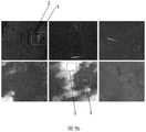
图4为本发明所述的一种光学遥感图像海面船只检测方法中步骤五与步骤六的效果图;Fig. 4 is the effect diagram of step 5 and step 6 in a kind of optical remote sensing image sea surface vessel detection method according to the present invention;
图5为本发明所述的一种光学遥感图像海面船只目标的快速检测方法中最后船只检测的效果图,其中绿色框3为第二步骤所提取的候选区域,红色框4为本发明的最终检测结果,图5a为对应图3候选区域提取的最终检测结果,图5b为其它典型遥感图像检测效果图。FIG. 5 is the effect diagram of the final ship detection in the method for fast detection of the target of ships on the sea surface of the optical remote sensing image according to the present invention, wherein the
具体实现方式specific implementation
结合图1至图5说明本实施方式,一种光学遥感图像海面船只目标的快速检测方法,该方法由以下步骤实现:1 to 5, the present embodiment, a method for fast detection of an optical remote sensing image sea surface vessel target, is implemented by the following steps:
步骤一、构建Adaboost船只检测分类器,基于Haar-like特征,训练Adaboost船只检测分类器,实现船只粗检测;
步骤一一、收集多源遥感影像,构建目标样本库;本实施方式中大量收集“吉林一号”卫星及谷歌卫星影像,具体裁剪1000张分辨率为1m的船只正样本,3000张包括云雾、海浪的负样本;Step 11: Collect multi-source remote sensing images and build a target sample library; in this embodiment, a large number of "Jilin No. 1" satellite and Google satellite images are collected, and 1000 positive samples of ships with a resolution of 1 m are specifically cropped, 3000 including clouds, fog, Negative samples of ocean waves;
步骤一二、对步骤一一中收集的样本进行旋转处理,丰富样本的多样性提高样本反应真实目标的变化不变性,本实施方式中分别旋转30、60和90度,使得最终样本库更新为正样本3000个,负样本9000个;Step 12: Rotate the samples collected in step 11 to enrich the diversity of the samples and improve the invariance of changes in the sample response to the real target. In this embodiment, rotate 30, 60 and 90 degrees respectively, so that the final sample library is updated to 3000 positive samples and 9000 negative samples;
步骤一三、提出一种RGB三通道光谱拉伸运算的预处理方法,提高船体与海面对比度信息;

其中R(x,y)为红色谱段的灰度值,G(x,y)和B(x,y)分别为绿色和蓝色谱段的灰度值,由于海水区域蓝、绿谱段能量较为相近,且红色谱段能量较低,因此利用公式(1)变换后,正如图2c所示,海水区域灰度值十分接近0(图2c为灰度图,不是二值图),图2a为原图,图2b为灰度变换后的效果图,图2c为本发明提出方法的效果图;图2c与常规的图像灰度化处理相比,RGB三通道拉伸运算极大地提高了船体与海面的对比度,降低船只漏检率。可以看到,红色船只1对比度提升效果明显,且对蓝绿色船只2亦可提升和海洋背景的对比度。where R(x,y) is the gray value of the red spectral band, G(x,y) and B(x,y) are the gray value of the green and blue spectral bands, respectively, due to the energy of the blue and green spectral bands in the seawater area are relatively similar, and the energy of the red chromatographic segment is low, so after using formula (1) to transform, as shown in Figure 2c, the gray value of the seawater area is very close to 0 (Figure 2c is a grayscale image, not a binary image), Figure 2a It is the original image, Fig. 2b is the effect image after grayscale transformation, and Fig. 2c is the effect image of the method proposed by the present invention; The contrast with the sea surface reduces the missed detection rate of ships. It can be seen that the contrast of the
所述RGB三通道光谱拉伸运算的预处理方法的优点在于,在目标检测领域,船只目标与背景的差异程度越高,越益于检测,本实施方式意在解决海上船只检测问题,其中,海水作为主要背景区域,以蓝、绿谱段信息为主,且二者能量较为相近,为提高船只与海水对比度,提出一种RGB谱间运算方法,利用该方法,抑止背景区域信息,提高船只与海水对比度,进而提升了船只检测准确率。The advantage of the preprocessing method of the RGB three-channel spectral stretching operation is that in the field of target detection, the higher the difference between the ship target and the background, the better the detection. This embodiment is intended to solve the problem of marine ship detection, wherein, As the main background area of seawater, blue and green spectrum information is the main information, and the two energy are relatively similar. In order to improve the contrast between the ship and the seawater, an arithmetic method between RGB spectrum is proposed. Using this method, the background area information is suppressed and the ship is improved. Contrast with sea water, thereby improving the accuracy of ship detection.
步骤一四、基于Haar-like特征,训练Adaboost船只检测分类器;Step 14. Based on Haar-like features, train the Adaboost vessel detection classifier;
利用一种自适应权值调节方法,反复训练基分类器,每次迭代都会根据上一次分类误差率调整训练样本权重,具体更新策略为:Using an adaptive weight adjustment method, the base classifier is repeatedly trained, and each iteration will adjust the training sample weight according to the last classification error rate. The specific update strategy is:


εt=Px(ht(xi)≠yi) (4)εt =Px (ht (xi )≠yi ) (4)
其中,r代表上一个迭代中分类正确,w代表上一个迭代中分类错误。Zt代表规范化因子,at表示弱分类器ht(x)的权重系数,ht(xi)表示弱分类器对于输入样本xi的预测值,εt计算在当前权值分布Dt(x)训练集上的分类误差率(Px代表概率)。Among them, r represents the correct classification in the previous iteration, and w represents the incorrect classification in the previous iteration. Zt represents the normalization factor, at represents the weight coefficient of the weak classifier ht (x), ht (xi ) represents the predicted value of the weak classifier for the input sample xi , εt is calculated in the current weight distribution Dt (x) Classification error rate on the training set (Px stands for probability).
提高被错误分类的样本权值,逐步增强弱分类器,然后,令所有弱分类器进行分类判断,再对分类结果按照弱分类器的错误率加权求和,将加权求和与平均分类比较得出基分类器的分类结果,具体公式如下:Increase the weights of the misclassified samples, gradually strengthen the weak classifiers, then make all the weak classifiers make classification judgments, and then weight the classification results according to the error rate of the weak classifiers, and compare the weighted sum with the average classification. The classification result of the base classifier, the specific formula is as follows:

步骤二、输入待测图像,并对所述待测图像进行RGB谱间变换后采用步骤一所述的Adaboost船只检测分类器进行待测图像中船只候选区域的提取;Step 2, inputting the image to be tested, and performing RGB inter-spectral conversion on the image to be tested, using the Adaboost vessel detection classifier described in
采用级联方法,将步骤一训练的Adaboost船只检测分类器后得到的多个基分类器,本实施方式中Adaboost船只检测分类器的参数设置为:基分类器数为19,基分类器召回率阈值为0.995,基分类器虚警率阈值为0.6。采用19个分类器,按简单到复杂的顺序串联,依次对待测区域进行判断,被判定为目标则继续传入下一级基分类器,否则被直接排除。The cascade method is adopted, and the multiple base classifiers obtained after the Adaboost ship detection classifier trained in
步骤三、利用物理约束条件,对步骤二中提取的候选区域进行模糊核为5的高斯滤波处理,降低海面噪声对后续分割处理的干扰,然后利用最大类间插分法进行二值化处理,实现疑似区域与背景的分割;Step 3: Using physical constraints, perform Gaussian filtering processing with a fuzzy kernel of 5 on the candidate region extracted in Step 2 to reduce the interference of sea surface noise on subsequent segmentation processing, and then use the maximum inter-class interpolation method to perform binarization processing, Realize the segmentation of suspected area and background;
步骤四、对步骤三处理后的图像运用形态学闭运算方法,修复目标轮廓信息;
步骤五、采用图像的二维像素信息计算步骤四中连通域的二维协方差矩阵,获得连通域主轴方向,并将图像按照主轴值进行旋转,保证旋转后目标主轴水平或垂直,具体方法如下:Step 5: Calculate the 2D covariance matrix of the connected domain in
图4为典型船只与海浪干扰目标的对比实验,图4a为计算船只目标的主轴方向及其对称性信息,图4b为典型干扰物海浪的对称性对比实验效果图;船体的对称性明显高于海浪。利用图像的二维像素信息 I(i,j)计算连通域的二维协方差矩阵进而得到连通域主轴方向;Figure 4 is a comparison experiment between a typical ship and a wave interference target, Figure 4a is the calculation of the main axis direction of the ship target and its symmetry information, Figure 4b is a comparison experiment effect of the symmetry of a typical interference object and waves; the symmetry of the hull is significantly higher than ocean waves. Use the two-dimensional pixel information I(i, j) of the image to calculate the two-dimensional covariance matrix of the connected domain to obtain the principal axis direction of the connected domain;
计算均值:Calculate the mean:

计算协方差:Calculate covariance:

计算主轴方向:Calculate the spindle direction:
θ=arctan(2×Cov_xy/(Cov_x2-Cov_y2))×0.5 (8)θ=arctan(2×Cov_xy/(Cov_x2 -Cov_y2 ))×0.5 (8)
步骤六、计算步骤五所获取连通域的全局对称性C3;Step 6, calculating the global symmetry C3 of the connected domain obtained in step 5;
对连通域分块处理,分别为左上区域TL、右上区域TR、左下区域DL、右下区域DR四部分;The connected domain is divided into four parts: the upper left areaTL , the upper right areaTR , the lower left areaDL , and the lower right areaDR ;
计算左右对称性:Compute left-right symmetry:

计算上下对称性:Compute the upper and lower symmetry:

计算全局对称性:Compute global symmetry:
C3=C1*C2 (11)C3 =C1 *C2 (11)
其中,S0表示目标区域像素总数,P(i,j)表示对称位置像素的乘积(如进行左右对称性计算时P(i,j)=sum((TL+DL).*(TR+DR)),若C3≥C0,则保留区域,否则直接排除该区域。Among them, S0 represents the total number of pixels in the target area, and P(i,j) represents the product of symmetrical position pixels (such as P(i,j)=sum((TL +DL ).*(TR + DR )), if C3 ≥C0 , the region is reserved, otherwise the region is directly excluded.
步骤七、计算联通域长宽比η;若η≥η0,则保留区域,否则直接排除。对称性阈值C0设置为0.1,长宽比阈值η0为3。Step 7: Calculate the aspect ratio η of the connected domain; if η≥η0 , keep the area, otherwise directly exclude it. The symmetry threshold C0 is set to 0.1, and the aspect ratio threshold η0 is set to 3.
步骤八、利用上述约束判断过程,最终确定船只目标区域及长宽信息;Step 8. Use the above constraint judgment process to finally determine the target area and length and width information of the vessel;
本实施方式中,利用吉林一号卫星数据收集229个不同成像条件、不同大小的船只测试集,其中包括139个成像背景良好的船只与90个存在严重干扰的船只,利用本发明的船只检测算法进行测试,利用精确率precision和召回率recall作为算法性能评价指标,具体公式:In this embodiment, the Jilin-1 satellite data is used to collect 229 test sets of ships with different imaging conditions and sizes, including 139 ships with good imaging background and 90 ships with serious interference, and the ship detection algorithm of the present invention is used. Carry out the test and use the precision rate and the recall rate as the performance evaluation indicators of the algorithm. The specific formula is:


式中Ntp代表指正确分类的正样本数,Nfp代表指被错误的标记为正样本的负样本数,Nfn代表指被错误的标记为负样本的正样本数,具体测试结果如表所示:In the formula, Ntp represents the number of positive samples that are correctly classified, Nfp represents the number of negative samples that are wrongly marked as positive samples, and Nfn represents the number of positive samples that are wrongly marked as negative samples. The specific test results are shown in the table. shown:
结合图5说明本实施方式,图5给出了本实施方式的检测效果图,其中红色框4为本实施方式最终检测出的船只目标。The present embodiment will be described with reference to FIG. 5 . FIG. 5 shows a detection effect diagram of the present embodiment, wherein the
由于多数现有船只检测专利仅关注检测精度而忽略检测系统的时效性,本实施方式的方法具有较快检测速度,实验采用主频2.3GHz的intel core i5处理器,利用vs2012软件平台进行实测,对2094×1245的遥感图像处理仅需527ms,实现高精度船只检测。Since most of the existing ship detection patents only focus on the detection accuracy and ignore the timeliness of the detection system, the method in this embodiment has a relatively fast detection speed. It only takes 527ms to process remote sensing images of 2094×1245, realizing high-precision ship detection.
Claims (3)


Priority Applications (1)
| Application Number | Priority Date | Filing Date | Title |
|---|---|---|---|
| CN201711226037.6ACN107992818B (en) | 2017-11-29 | 2017-11-29 | Method for detecting sea surface ship target by optical remote sensing image |
Applications Claiming Priority (1)
| Application Number | Priority Date | Filing Date | Title |
|---|---|---|---|
| CN201711226037.6ACN107992818B (en) | 2017-11-29 | 2017-11-29 | Method for detecting sea surface ship target by optical remote sensing image |
Publications (2)
| Publication Number | Publication Date |
|---|---|
| CN107992818A CN107992818A (en) | 2018-05-04 |
| CN107992818Btrue CN107992818B (en) | 2020-12-25 |
Family
ID=62034371
Family Applications (1)
| Application Number | Title | Priority Date | Filing Date |
|---|---|---|---|
| CN201711226037.6AActiveCN107992818B (en) | 2017-11-29 | 2017-11-29 | Method for detecting sea surface ship target by optical remote sensing image |
Country Status (1)
| Country | Link |
|---|---|
| CN (1) | CN107992818B (en) |
Families Citing this family (9)
| Publication number | Priority date | Publication date | Assignee | Title |
|---|---|---|---|---|
| CN111368599B (en)* | 2018-12-26 | 2023-11-07 | 北京眼神智能科技有限公司 | Remote sensing image sea surface ship detection methods, devices, readable storage media and equipment |
| CN109934088A (en)* | 2019-01-10 | 2019-06-25 | 海南大学 | A deep learning-based method for the identification of ships on the sea surface |
| CN109919240A (en)* | 2019-03-15 | 2019-06-21 | 维沃移动通信有限公司 | Training method, device and terminal equipment for facial feature point model |
| CN110059640B (en)* | 2019-04-22 | 2020-09-01 | 长光卫星技术有限公司 | Sea surface ship on-orbit identification method based on near-infrared spectrum band of optical remote sensing satellite |
| CN111931688A (en)* | 2020-08-27 | 2020-11-13 | 珠海大横琴科技发展有限公司 | Ship recognition method and device, computer equipment and storage medium |
| CN112200825B (en)* | 2020-10-14 | 2022-06-14 | 长光卫星技术股份有限公司 | Space target luminosity inversion method based on Bell coding image |
| CN112329613B (en)* | 2020-11-03 | 2021-10-15 | 珠海大横琴科技发展有限公司 | Sea wave influence launching detection method and device, electronic equipment and storage medium |
| CN117115436B (en)* | 2023-07-10 | 2025-03-28 | 中国科学院空天信息创新研究院 | Ship posture detection method, device, electronic equipment and storage medium |
| CN120126185B (en)* | 2025-05-13 | 2025-07-25 | 华东交通大学 | A method, system, electronic device and medium for human body recognition in a dense smoke environment |
Citations (4)
| Publication number | Priority date | Publication date | Assignee | Title |
|---|---|---|---|---|
| CN102855622A (en)* | 2012-07-18 | 2013-01-02 | 中国科学院自动化研究所 | Infrared remote sensing image sea ship detecting method based on significance analysis |
| CN105513041A (en)* | 2015-10-28 | 2016-04-20 | 深圳大学 | Large-scale remote sensing image sea-land segmentation method and system |
| CN105654091A (en)* | 2014-11-27 | 2016-06-08 | 航天恒星科技有限公司 | Detection method and apparatus for sea-surface target |
| CN106845372A (en)* | 2016-12-31 | 2017-06-13 | 华中科技大学 | The ship target detection recognition method and system of a kind of space remote sensing optical imagery |
Family Cites Families (1)
| Publication number | Priority date | Publication date | Assignee | Title |
|---|---|---|---|---|
| US9196044B2 (en)* | 2014-02-26 | 2015-11-24 | Raytheon Company | False alarm rejection for boat detection candidates |
- 2017
- 2017-11-29CNCN201711226037.6Apatent/CN107992818B/enactiveActive
Patent Citations (4)
| Publication number | Priority date | Publication date | Assignee | Title |
|---|---|---|---|---|
| CN102855622A (en)* | 2012-07-18 | 2013-01-02 | 中国科学院自动化研究所 | Infrared remote sensing image sea ship detecting method based on significance analysis |
| CN105654091A (en)* | 2014-11-27 | 2016-06-08 | 航天恒星科技有限公司 | Detection method and apparatus for sea-surface target |
| CN105513041A (en)* | 2015-10-28 | 2016-04-20 | 深圳大学 | Large-scale remote sensing image sea-land segmentation method and system |
| CN106845372A (en)* | 2016-12-31 | 2017-06-13 | 华中科技大学 | The ship target detection recognition method and system of a kind of space remote sensing optical imagery |
Non-Patent Citations (1)
| Title |
|---|
| 基于图像对称性的车辆遥感识别;陈任 等;《国土资源遥感》;20170106;第28卷(第4期);正文第1-2章* |
Also Published As
| Publication number | Publication date |
|---|---|
| CN107992818A (en) | 2018-05-04 |
Similar Documents
| Publication | Publication Date | Title |
|---|---|---|
| CN107992818B (en) | Method for detecting sea surface ship target by optical remote sensing image | |
| CN105809198B (en) | SAR image target recognition method based on depth confidence network | |
| Cao et al. | Ship recognition method combined with image segmentation and deep learning feature extraction in video surveillance | |
| CN103400156B (en) | Based on the High Resolution SAR image Ship Detection of CFAR and rarefaction representation | |
| Xue et al. | Rethinking automatic ship wake detection: State-of-the-art CNN-based wake detection via optical images | |
| CN110298280A (en) | A kind of ocean eddy recognition methods based on MKL multiple features fusion | |
| CN108171752A (en) | A kind of sea ship video detection and tracking based on deep learning | |
| CN108427958A (en) | Adaptive weight convolutional neural networks underwater sonar image classification method based on deep learning | |
| CN104732215A (en) | Remote-sensing image coastline extracting method based on information vector machine | |
| CN101866427A (en) | Fabric defect detection and classification method | |
| CN102830404B (en) | LiDAR Ground Target Recognition Method Based on Range Image | |
| CN108021890B (en) | High-resolution remote sensing image port detection method based on PLSA and BOW | |
| Du et al. | Semisupervised SAR ship detection network via scene characteristic learning | |
| CN103632382A (en) | Compressive sensing-based real-time multi-scale target tracking method | |
| CN110516525A (en) | SAR image target recognition method based on GAN and SVM | |
| Liu et al. | A multiscale feature pyramid SAR ship detection network with robust background interference | |
| CN114821358A (en) | Optical remote sensing image marine ship target extraction and identification method | |
| Zhang et al. | Label assignment matters: A gaussian assignment strategy for tiny object detection | |
| CN107506699A (en) | A kind of SAR image sorting technique based on textural characteristics and DBN | |
| CN115909072B (en) | A water column detection method for impact point based on improved YOLOv4 algorithm | |
| Qi et al. | Addressing fine-grained lake water body extraction: A hybrid approach combining vision transformer and geodesic active contour | |
| Wangli et al. | Foxtail Millet ear detection approach based on YOLOv4 and adaptive anchor box adjustment | |
| CN114283336A (en) | An anchor-free remote sensing image small object detection method based on hybrid attention | |
| Hu et al. | Research on bamboo defect segmentation and classification based on improved u-net network | |
| CN114140698A (en) | Water system information extraction algorithm based on FasterR-CNN |
Legal Events
| Date | Code | Title | Description |
|---|---|---|---|
| PB01 | Publication | ||
| PB01 | Publication | ||
| SE01 | Entry into force of request for substantive examination | ||
| SE01 | Entry into force of request for substantive examination | ||
| GR01 | Patent grant | ||
| GR01 | Patent grant | ||
| CP03 | Change of name, title or address | Address after:No. 1299, Mingxi Road, Beihu science and Technology Development Zone, Changchun City, Jilin Province Patentee after:Changguang Satellite Technology Co.,Ltd. Address before:No.1759 Mingxi Road, Gaoxin North District, Changchun City, Jilin Province Patentee before:CHANG GUANG SATELLITE TECHNOLOGY Co.,Ltd. | |
| CP03 | Change of name, title or address | ||
| PE01 | Entry into force of the registration of the contract for pledge of patent right | Denomination of invention:A method for detecting ship targets on sea surfaces in optical remote sensing images Granted publication date:20201225 Pledgee:Jilin Province Trust Co.,Ltd. Pledgor:Changguang Satellite Technology Co.,Ltd. Registration number:Y2025980033309 |