CN107749193B - Driving risk analysis and risk data transmission method and device - Google Patents
Driving risk analysis and risk data transmission method and deviceDownload PDFInfo
- Publication number
- CN107749193B CN107749193BCN201710819290.6ACN201710819290ACN107749193BCN 107749193 BCN107749193 BCN 107749193BCN 201710819290 ACN201710819290 ACN 201710819290ACN 107749193 BCN107749193 BCN 107749193B
- Authority
- CN
- China
- Prior art keywords
- data
- risk
- area
- vehicle
- traffic environment
- Prior art date
- Legal status (The legal status is an assumption and is not a legal conclusion. Google has not performed a legal analysis and makes no representation as to the accuracy of the status listed.)
- Active
Links
Images


Classifications
- G—PHYSICS
- G05—CONTROLLING; REGULATING
- G05D—SYSTEMS FOR CONTROLLING OR REGULATING NON-ELECTRIC VARIABLES
- G05D1/00—Control of position, course, altitude or attitude of land, water, air or space vehicles, e.g. using automatic pilots
- G05D1/02—Control of position or course in two dimensions
- G05D1/021—Control of position or course in two dimensions specially adapted to land vehicles
- G05D1/0212—Control of position or course in two dimensions specially adapted to land vehicles with means for defining a desired trajectory
- G05D1/0214—Control of position or course in two dimensions specially adapted to land vehicles with means for defining a desired trajectory in accordance with safety or protection criteria, e.g. avoiding hazardous areas
- G—PHYSICS
- G08—SIGNALLING
- G08G—TRAFFIC CONTROL SYSTEMS
- G08G1/00—Traffic control systems for road vehicles
- G08G1/16—Anti-collision systems
- G08G1/164—Centralised systems, e.g. external to vehicles
- H—ELECTRICITY
- H04—ELECTRIC COMMUNICATION TECHNIQUE
- H04W—WIRELESS COMMUNICATION NETWORKS
- H04W4/00—Services specially adapted for wireless communication networks; Facilities therefor
- H04W4/02—Services making use of location information
- H04W4/029—Location-based management or tracking services
- G—PHYSICS
- G08—SIGNALLING
- G08G—TRAFFIC CONTROL SYSTEMS
- G08G1/00—Traffic control systems for road vehicles
- G08G1/01—Detecting movement of traffic to be counted or controlled
- G08G1/0104—Measuring and analyzing of parameters relative to traffic conditions
- G08G1/0108—Measuring and analyzing of parameters relative to traffic conditions based on the source of data
- G08G1/0116—Measuring and analyzing of parameters relative to traffic conditions based on the source of data from roadside infrastructure, e.g. beacons
- G—PHYSICS
- G08—SIGNALLING
- G08G—TRAFFIC CONTROL SYSTEMS
- G08G1/00—Traffic control systems for road vehicles
- G08G1/01—Detecting movement of traffic to be counted or controlled
- G08G1/0104—Measuring and analyzing of parameters relative to traffic conditions
- G08G1/0125—Traffic data processing
- G08G1/0133—Traffic data processing for classifying traffic situation
- G—PHYSICS
- G08—SIGNALLING
- G08G—TRAFFIC CONTROL SYSTEMS
- G08G1/00—Traffic control systems for road vehicles
- G08G1/16—Anti-collision systems
- G08G1/165—Anti-collision systems for passive traffic, e.g. including static obstacles, trees
- G—PHYSICS
- G08—SIGNALLING
- G08G—TRAFFIC CONTROL SYSTEMS
- G08G1/00—Traffic control systems for road vehicles
- G08G1/16—Anti-collision systems
- G08G1/166—Anti-collision systems for active traffic, e.g. moving vehicles, pedestrians, bikes
- H—ELECTRICITY
- H04—ELECTRIC COMMUNICATION TECHNIQUE
- H04W—WIRELESS COMMUNICATION NETWORKS
- H04W4/00—Services specially adapted for wireless communication networks; Facilities therefor
- H04W4/02—Services making use of location information
- H04W4/024—Guidance services
- H—ELECTRICITY
- H04—ELECTRIC COMMUNICATION TECHNIQUE
- H04W—WIRELESS COMMUNICATION NETWORKS
- H04W4/00—Services specially adapted for wireless communication networks; Facilities therefor
- H04W4/30—Services specially adapted for particular environments, situations or purposes
- H04W4/40—Services specially adapted for particular environments, situations or purposes for vehicles, e.g. vehicle-to-pedestrians [V2P]
- H04W4/44—Services specially adapted for particular environments, situations or purposes for vehicles, e.g. vehicle-to-pedestrians [V2P] for communication between vehicles and infrastructures, e.g. vehicle-to-cloud [V2C] or vehicle-to-home [V2H]
- H—ELECTRICITY
- H04—ELECTRIC COMMUNICATION TECHNIQUE
- H04W—WIRELESS COMMUNICATION NETWORKS
- H04W4/00—Services specially adapted for wireless communication networks; Facilities therefor
- H04W4/12—Messaging; Mailboxes; Announcements
- H—ELECTRICITY
- H04—ELECTRIC COMMUNICATION TECHNIQUE
- H04W—WIRELESS COMMUNICATION NETWORKS
- H04W4/00—Services specially adapted for wireless communication networks; Facilities therefor
- H04W4/90—Services for handling of emergency or hazardous situations, e.g. earthquake and tsunami warning systems [ETWS]
Landscapes
- Physics & Mathematics (AREA)
- General Physics & Mathematics (AREA)
- Engineering & Computer Science (AREA)
- Computer Networks & Wireless Communication (AREA)
- Signal Processing (AREA)
- Chemical & Material Sciences (AREA)
- Analytical Chemistry (AREA)
- Aviation & Aerospace Engineering (AREA)
- Radar, Positioning & Navigation (AREA)
- Remote Sensing (AREA)
- Automation & Control Theory (AREA)
- Traffic Control Systems (AREA)
Abstract
Translated fromChinese
Description
Translated fromChinese技术领域technical field
本公开涉及车联网技术领域,特别涉及一种驾驶风险分析及风险数据发送方法及装置。The present disclosure relates to the technical field of Internet of Vehicles, and in particular, to a driving risk analysis and risk data sending method and device.
背景技术Background technique
车辆到万物(Vehicle to Everything,V2X)技术是车联网的新兴发展趋势,V2X是车辆到车辆(Vehicle to Vehicle,V2V)、车辆到行人(Vehicle to Pedestrian,V2P)以及车辆到网络(Vehicle to Internet,V2I)的统称。为了保障车辆的安全行驶,道路上的不同车辆间需要能彼此交互一些数据,通过对这些数据的处理可以获知道路、车辆状况,如前方的车辆事故等;甚至是可以提前预测事故的发生,进而对司机提出警告,使其改变驾驶策略。Vehicle to Everything (V2X) technology is an emerging development trend of the Internet of Vehicles. V2X is Vehicle to Vehicle (V2V), Vehicle to Pedestrian (V2P) and Vehicle to Internet (Vehicle to Internet). , V2I) collectively. In order to ensure the safe driving of vehicles, different vehicles on the road need to be able to exchange some data with each other. Through the processing of these data, the road and vehicle conditions, such as the vehicle accident ahead, can be obtained; even the occurrence of accidents can be predicted in advance, and then Warn the driver to change his driving strategy.
而随着V2X技术的发展,逐渐引入长期演进-V2X(Long Term Evolution-V2X,LTE-V2X)技术:它将车辆作为一个蜂窝网络的用户设备(User Equipment,UE),UE之间可以采用广播的方式进行直连通信,而不需要经过基站转发。又或者,UE还可以采用单播的方式将数据发送给基站,由基站采用广播或组播的方式转发给其他UE。With the development of V2X technology, Long Term Evolution-V2X (LTE-V2X) technology is gradually introduced: it regards the vehicle as a user equipment (User Equipment, UE) of a cellular network, and broadcasts can be used between UEs. way to communicate directly without the need for forwarding by the base station. Alternatively, the UE may also send the data to the base station in a unicast manner, and the base station may forward the data to other UEs in a broadcast or multicast manner.
然而,由于在数据发送过程中均采用广播的方式来发送数据,其数据量大,而基站所能够提供的数据传输资源有限,使得发送数据仍然存在较大的时延,通信性能较差。However, since the data is transmitted by broadcasting in the process of data transmission, the amount of data is large, and the data transmission resources provided by the base station are limited, so that there is still a large delay in transmitting data, and the communication performance is poor.
发明内容SUMMARY OF THE INVENTION
本公开实施例提供了一种驾驶风险分析及风险数据发送方法及装置,可以解决实现V2X相关应用时数据发送时延大、通信性能差的问题。The embodiments of the present disclosure provide a driving risk analysis and risk data sending method and device, which can solve the problems of large data sending delay and poor communication performance when implementing V2X related applications.
第一方面,提供了一种驾驶风险分析及风险数据发送方法,包括:A first aspect provides a driving risk analysis and risk data sending method, including:
获取待进行风险分析的第一设备的位置;obtaining the location of the first device to be subjected to risk analysis;
根据所述位置对应的车辆行驶线,确定第一风险区域,所述第一风险区域是指对所述第一设备所在车辆的驾驶行为有影响的区域;对所述第一风险区域进行筛选,得到风险数据;将所述风险数据发送至第一设备;其中,所述风险数据包括与所述第一设备所在车辆有碰撞风险的车辆、行人、障碍物状态数据,以及对所述第一设备所在车辆的驾驶行为有影响的交通环境数据。Determine a first risk area according to the vehicle driving line corresponding to the position, where the first risk area refers to an area that affects the driving behavior of the vehicle where the first device is located; screen the first risk area, Obtaining risk data; sending the risk data to the first device; wherein the risk data includes vehicle, pedestrian, and obstacle status data that are at risk of collision with the vehicle where the first device is located, and data on the state of the first device Traffic environment data that affects the driving behavior of the vehicle you are in.
其中,该风险数据可以包括车辆状态数据、路侧传感器以及车载传感器的感知数据、交通环境数据,其中,车辆状态数据是车辆本身的运动状态,车载传感器的感知数据是车辆感知的周围车辆、行人、障碍物状态,路侧传感器的感知数据是路侧感知的车辆、行人、障碍物状态,交通环境数据由第二设备产生,该第二设备可以是第一设备,也可以是例如信号灯、标志牌以及中心服务单元(Central Service Unit,CSU)等设备。The risk data may include vehicle state data, roadside sensors, perception data of on-board sensors, and traffic environment data, where the vehicle state data is the motion state of the vehicle itself, and the perception data of the on-board sensors is the surrounding vehicles and pedestrians perceived by the vehicle. , Obstacle status, the perception data of roadside sensors is the status of vehicles, pedestrians, and obstacles perceived by the roadside, and the traffic environment data is generated by a second device, which can be the first device, or, for example, a signal light, a sign Brands and equipment such as the Central Service Unit (CSU).
对于信号灯、标志牌等第二设备来说,其对应具有管控区域,由于这类第二设备会设置于路段上的某个位置,因此,其状态的变化所影响到的区域即是其管控区域,因此,在本公开实施例中可以针对这类第二设备维护其对应的管控区域数据库,该管控区域数据库可以是独立于地理信息数据库的一个数据库,也可以是与地理信息数据库为同一个数据库,以使得任一第二设备的状态发生变化时,均可以通过该管控区域数据库确定该第二设备所在位置所对应的管控区域。For the second equipment such as signal lights and signs, it has a corresponding control area. Since this type of second equipment will be set at a certain position on the road section, the area affected by the change of its state is the control area. , therefore, in the embodiment of the present disclosure, a corresponding control area database may be maintained for this type of second device, and the control area database may be a database independent of the geographic information database, or may be the same database as the geographic information database. , so that when the state of any second device changes, the management and control area corresponding to the location of the second device can be determined through the management and control area database.
本公开实施例提供的方法,通过风险分析设备实时为第一设备所在车辆筛选其附近的风险数据,由于能够通过筛选降低风险数据的数据量,大大减少了数据发送的时延,并且还能够降低设备之间互相通告车辆状态数据的带宽要求,提高了通信性能,同时能够使得第一设备灵活的感知附近车辆的状态,以达到辅助驾驶的目的。In the method provided by the embodiment of the present disclosure, the risk analysis device is used to screen the risk data in the vicinity of the vehicle where the first device is located in real time. Since the data volume of the risk data can be reduced by screening, the delay in data transmission is greatly reduced, and the The devices notify each other of the bandwidth requirements of the vehicle status data, which improves the communication performance, and at the same time enables the first device to flexibly perceive the status of nearby vehicles, so as to achieve the purpose of assisting driving.
在一种可能设计中,所述根据所述位置对应的车辆行驶线,确定第一风险区域包括:In a possible design, the determining of the first risk area according to the vehicle travel line corresponding to the position includes:
在一种可能设计中,基于所述位置,确定所述第一设备对应的车辆行驶线,所述第一设备对应的车辆行驶线包括所述第一设备所在的车辆行驶线、所述第一设备的相邻车辆行驶线以及所述第一设备的交叉行驶线中至少一条;In a possible design, a vehicle travel line corresponding to the first device is determined based on the location, where the vehicle travel line corresponding to the first device includes a vehicle travel line where the first device is located, the first device At least one of the adjacent vehicle travel lines of the equipment and the cross travel lines of the first equipment;
将第一子区域、第二子区域和第三子区域中至少一个子区域,划分为所述第一风险区域;其中,所述第一子区域为与所述第一设备处于同一车辆行驶线上,且位于所述第一设备的前向和/或后向的第一预设范围内的区域;所述第二子区域为处于所述第一设备的相邻车辆行驶线上,且位于所述第一设备的前向和/或后向的第二预设范围内的区域;第三子区域为处于所述第一设备的车辆行驶线的交叉行驶线上,且驶向交叉点的第三预设范围内的区域。Divide at least one sub-area among the first sub-area, the second sub-area and the third sub-area into the first risk area; wherein, the first sub-area is on the same vehicle driving line as the first device on the front and/or rear of the first device and within the first preset range; the second sub-region is on the adjacent vehicle travel line of the first device, and is located in The area within the second preset range in the forward direction and/or the rear direction of the first device; the third sub-area is located on the crossing travel line of the vehicle travel line of the first device and heading to the intersection The area within the third preset range.
其中,第一风险区域的划分策略可以根据第一设备的请求或者风险分析设备的预设置确定。Wherein, the division strategy of the first risk area may be determined according to a request of the first device or a preset setting of the risk analysis device.
在一种可能设计中,所述对所述第一风险区域进行筛选,得到风险数据包括:In a possible design, the screening of the first risk area to obtain risk data includes:
对车辆状态数据库的车辆状态数据和/或传感器感知数据库的感知数据按所述第一风险区域进行筛选,将位置处于所述第一风险区域的车辆状态数据和/或感知数据作为风险数据。在这种可能设计中,结合车辆状态数据和感知数据能够驾驶行为提供更加全面的数据,参考价值更高。The vehicle state data of the vehicle state database and/or the perception data of the sensor perception database are filtered according to the first risk area, and the vehicle state data and/or perception data located in the first risk area are used as risk data. In this possible design, the combination of vehicle state data and perception data can provide more comprehensive data on driving behavior with higher reference value.
在一种可能设计中,所述风险数据是通过预测得到的当前时刻的风险数据。在这种可能设计中,风险数据可以是对通过初步筛选得到的风险数据根据当前时间和数据的时间差来预测所得到的预测数据,这种预测数据可以让第一设备直接使用,而不必根据当前时间和数据的时差来进行预测。In a possible design, the risk data is the risk data at the current moment obtained through prediction. In this possible design, the risk data may be prediction data obtained by predicting the risk data obtained through preliminary screening according to the current time and the time difference between the data. time and the time difference of the data to make predictions.
在一种可能设计中,所述对所述第一风险区域进行筛选,得到风险数据包括:对交通环境数据库的交通环境数据按所述第一风险区域进行筛选,将位置处于所述第一风险区域的交通环境数据作为风险数据。在这种可能设计中,还可以结合交通环境数据来获知当前道路上发生的紧急事件或是道路拥堵情况又或者是道路上一些信号灯或指示牌所指示的路况,在节约传输资源的同时可以达到更好的提示效果。In a possible design, the screening of the first risk area to obtain the risk data includes: screening the traffic environment data in the traffic environment database according to the first risk area, and placing the location in the first risk Regional traffic environment data is used as risk data. In this possible design, it is also possible to combine the traffic environment data to learn about the emergency events occurring on the current road, the road congestion situation, or the road conditions indicated by some signal lights or signs on the road, which can save transmission resources while achieving Better prompt effect.
在一种可能设计中,所述将所述风险数据发送至第一设备包括:In one possible design, the sending the risk data to the first device includes:
当到达第一周期时,将紧急程度大于或等于预设高级别的风险数据发送给所述第一设备,当达到第二周期时,将紧急程度大于或等于预设中级别的风险数据发送给所述第一设备,当达到第三周期时,将所述风险数据发送给所述第一设备,其中,所述第一周期的时长跨度小于所述第二周期的时长跨度、第二周期的时长跨度小于所述第三周期的时长跨度;该设计可以通过对风险数据以紧急程度进行分类,并基于紧急程度采取不同的发送策略,能够提高紧急的风险数据的及时性,也能够保证相对不紧急的风险数据的正常发送。When the first period is reached, the risk data with the emergency degree greater than or equal to the preset high level is sent to the first device, and when the second period is reached, the risk data with the emergency degree greater than or equal to the preset medium level is sent to the first device. The first device sends the risk data to the first device when the third cycle is reached, wherein the time span of the first cycle is smaller than the time span of the second cycle and the duration of the second cycle. The time span is smaller than the time span of the third period; this design can improve the timeliness of urgent risk data by classifying risk data according to the urgency, and adopting different sending strategies based on the urgency Normal sending of urgent risk data.
在一种可能设计中,所述不同紧急程度对应的发送策略由风险分析设备预配置或根据所述第一设备的请求确定。In a possible design, the sending policies corresponding to the different urgency levels are preconfigured by the risk analysis device or determined according to the request of the first device.
在一种可能设计中,所述将所述风险数据发送至第一设备包括:In one possible design, the sending the risk data to the first device includes:
当所述风险数据包括两个或两个以上设备的状态数据时,将所述风险数据打包成一个数据包,向所述第一设备发送所述数据包;或,当所述风险数据包括两个或两个以上设备的状态数据时,将每个状态数据打包成一个数据包,得到多个数据包,依次向所述第一设备发送所述多个数据包。When the risk data includes the status data of two or more devices, the risk data is packaged into one data packet, and the data packet is sent to the first device; or, when the risk data includes two In the case of state data of one or more devices, each state data is packaged into a data packet to obtain multiple data packets, and the multiple data packets are sequentially sent to the first device.
在一种可能设计中,所述依次向所述第一设备发送所述多个数据包包括:按照状态数据的紧急程度的级别从大到小的顺序,向所述第一设备发送所述多个数据包。该可能设计可以使得第一设备可以按照紧急程度接收数据包,从而按照最紧急的情况来进行驾驶提示,大大提高了数据的及时性。In a possible design, the sending the multiple data packets to the first device in sequence includes: sending the multiple data packets to the first device in descending order of the urgency of the status data. packets. This possible design enables the first device to receive data packets according to the urgency, so as to give driving prompts according to the most urgent situation, which greatly improves the timeliness of the data.
在一种可能设计中,第一设备与风险分析设备之间的数据交互基于蜂窝网络的网元设备的LBO功能或MEC功能进行,其中,所述网元设备为无线基站、或无线核心网网元、或处于两者之间的网元。本公开所提供的技术方案可以应用于任一种网络架构中,例如2G、3G、4G和5G中,其具体实现过程同理。In a possible design, the data interaction between the first device and the risk analysis device is performed based on the LBO function or the MEC function of the network element equipment of the cellular network, wherein the network element equipment is a wireless base station or a wireless core network network element, or a network element in between. The technical solutions provided by the present disclosure can be applied to any network architecture, such as 2G, 3G, 4G and 5G, and the specific implementation process thereof is the same.
在一种可能设计中,所述将所述风险数据发送至第一设备包括:In one possible design, the sending the risk data to the first device includes:
获取保存的所述第一设备的地址信息以及所述第一设备所属直接与风险分析设备进行交互的网元设备的地址信息,通过所述第一设备所属网元设备发送所述风险数据。Acquire the stored address information of the first device and the address information of the network element device to which the first device directly interacts with the risk analysis device, and send the risk data through the network element device to which the first device belongs.
在一种可能设计中,所述第一设备包括任一种支持车辆到万物V2X的终端设备。In a possible design, the first device includes any terminal device that supports vehicle-to-everything V2X.
在一种可能设计中,所述支持V2X的终端设备包括:车载单元OBU、智能手机、车载控制单元T-Box或行车记录仪。In a possible design, the terminal equipment supporting V2X includes: an on-board unit OBU, a smart phone, a on-board control unit T-Box or a driving recorder.
第二方面,提供了一种驾驶风险分析及风险数据发送方法,应用于风险分析设备,包括:接收交通环境数据,获取目标位置,所述目标位置为待进行风险分析的交通环境数据产生位置;根据所述目标位置对应的车辆行驶线,确定第二风险区域,所述第二风险区域是指受到所述目标位置的第二设备的状态变化影响的区域;对所述第二风险区域内的第一设备进行筛选;将所述交通环境数据发送至通过筛选得到的至少一个第一设备。In a second aspect, a driving risk analysis and risk data sending method is provided, which is applied to a risk analysis device, including: receiving traffic environment data, and acquiring a target location, where the target location is a location where traffic environment data to be subjected to risk analysis is generated; A second risk area is determined according to the vehicle travel line corresponding to the target location, where the second risk area refers to an area affected by the state change of the second device at the target location; The first device performs screening; and the traffic environment data is sent to at least one first device obtained through screening.
在一种可能设计中,当通过筛选未筛选出任何设备时,则忽略所述交通环境数据。在实际场景中也可能出现第二风险区域中并没有受到影响的车辆,因此,也可以在未筛选到任何设备时,不对交通环境数据进行发送。In one possible design, the traffic environment data is ignored when no devices are filtered out by the filtering. Vehicles that are not affected in the second risk area may also appear in actual scenarios, and therefore, traffic environment data may not be sent when no device is screened.
在一种可能设计中,所述根据所述目标位置对应的车辆行驶线,确定第二风险区域包括:当所述第二设备为第一设备时,确定所述目标位置上第一设备对应的车辆行驶线,所述第一设备对应的车辆行驶线包括所述第一设备所在的车辆行驶线、所述第一设备的相邻车辆行驶线以及所述第一设备的交叉行驶线中至少一条;沿所述第一设备对应的车辆行驶线,将位于所述第一设备的前向和/或后向的第四预设范围内的区域划分为第二风险区域。In a possible design, the determining the second risk area according to the vehicle travel line corresponding to the target position includes: when the second device is the first device, determining the target position corresponding to the first device A vehicle travel line, the vehicle travel line corresponding to the first device includes at least one of a vehicle travel line where the first device is located, an adjacent vehicle travel line of the first device, and a cross travel line of the first device ; along the vehicle travel line corresponding to the first device, dividing the area located in the forward and/or rearward fourth preset range of the first device into a second risk area.
在一种可能设计中,所述根据所述目标位置对应的车辆行驶线,确定第二风险区域包括:根据所述目标位置上第二设备的管控区域,获取位于所述目标位置上的第二设备的管控区域内的车辆行驶线;沿所述车辆行驶线,将驶向目标位置的第五预设范围内的区域划分为第二风险区域。In a possible design, the determining the second risk area according to the vehicle travel line corresponding to the target position includes: obtaining a second risk area located at the target position according to the control area of the second device at the target position The vehicle travel line in the control area of the device; along the vehicle travel line, the area within the fifth preset range heading for the target position is divided into a second risk area.
在一种可能设计中,所述第二设备为交通信号灯、指示牌或中央服务单元CSU。In one possible design, the second device is a traffic light, a sign or a central service unit CSU.
在一种可能设计中,所述第二风险区域的划分策略根据交通环境数据的事件类型和/或路段配置变化。In a possible design, the division strategy of the second risk area varies according to the event type and/or the road segment configuration of the traffic environment data.
在一种可能设计中,所述对所述第二风险区域内的第一设备进行筛选包括:对车辆状态数据库的车辆状态数据按所述第二风险区域进行筛选,得到位置处于所述第二风险区域的至少一个第一设备。In a possible design, the screening of the first device in the second risk area includes: screening the vehicle state data in the vehicle state database according to the second risk area, to obtain a position in the second risk area. At least one first device of the risk area.
在一种可能设计中,所述将所述交通环境数据发送至通过筛选得到的至少一个第一设备包括:当至少一个第一设备为两个或两个以上时,根据所述至少一个第一设备与所述目标位置之间的距离从近到远的次序,将所述交通环境数据分别发送至所述至少一个第一设备。为了保证事件通知的及时性要求,可以按照至少一个第一设备的位置确定每个第一设备与事件发生位置也即是目标位置之间的距离,再根据距离从近到远的次序来发送该交通环境数据。In a possible design, the sending the traffic environment data to the at least one first device obtained by screening includes: when the at least one first device is two or more, according to the at least one first device The traffic environment data are respectively sent to the at least one first device in order of the distance between the device and the target position from near to far. In order to ensure the timeliness of the event notification, the distance between each first device and the event location, that is, the target location, can be determined according to the location of at least one first device, and then the distance is sent according to the order of distance from near to far. Traffic environment data.
在一种可能设计中,所述将所述交通环境数据发送至通过筛选得到的至少一个第一设备包括:当到达所述至少一个第一设备中任一个第一设备的风险分析周期时,在风险数据中加入所述交通环境数据发送至所述第一设备。In a possible design, the sending the traffic environment data to the at least one first device obtained through screening includes: when a risk analysis period of any one of the at least one first device is reached, in the The traffic environment data is added to the risk data and sent to the first device.
第三方面,提供了一种驾驶风险分析及风险数据发送装置,应用于风险分析设备,所述装置包括多个功能模块,以实现上述第一方面以及第一方面的任一种可能设计的驾驶风险分析及风险数据发送方法。In a third aspect, a driving risk analysis and risk data sending device is provided, which is applied to a risk analysis device, and the device includes a plurality of functional modules, so as to realize the driving of the first aspect and any possible design of the first aspect. Risk analysis and risk data delivery method.
第四方面,提供了一种驾驶风险分析及风险数据发送装置,应用于风险分析设备,所述装置包括多个功能模块,以实现上述第二方面以及第二方面的任一种可能设计的驾驶风险分析及风险数据发送方法。In a fourth aspect, a driving risk analysis and risk data sending device is provided, which is applied to a risk analysis device, and the device includes a plurality of functional modules, so as to realize the driving of the second aspect and any possible design of the second aspect. Risk analysis and risk data delivery method.
第五方面,提供了一种风险分析设备,所述风险分析设备存储有多条指令,所述指令适于由处理器用来加载并执行上述第一方面以及第一方面的任一种可能设计的驾驶风险分析及风险数据发送方法。In a fifth aspect, a risk analysis device is provided, the risk analysis device stores a plurality of instructions, the instructions are suitable for being used by a processor to load and execute the first aspect and any one of the possible designs of the first aspect. Driving risk analysis and risk data transmission method.
第六方面,提供了一种风险分析设备,所述风险分析设备存储有多条指令,所述指令适于由处理器用来加载并执行上述第二方面以及第二方面的任一种可能设计的驾驶风险分析及风险数据发送方法。A sixth aspect provides a risk analysis device, the risk analysis device stores a plurality of instructions, the instructions are suitable for being used by a processor to load and execute the second aspect and any one of the possible designs of the second aspect. Driving risk analysis and risk data transmission method.
第七方面,提供了一种计算机可读存储介质,所述计算机可读存储介质上存储有指令,所述指令被处理器执行以完成上述第一方面以及第一方面的任一种可能设计的驾驶风险分析及风险数据发送方法。In a seventh aspect, a computer-readable storage medium is provided, and instructions are stored on the computer-readable storage medium, and the instructions are executed by a processor to complete the first aspect and any one of the possible designs of the first aspect. Driving risk analysis and risk data transmission method.
第八方面,提供了一种计算机可读存储介质,所述计算机可读存储介质上存储有指令,所述指令被处理器执行以完成上述第二方面以及第二方面的任一种可能设计的驾驶风险分析及风险数据发送方法。In an eighth aspect, a computer-readable storage medium is provided, and instructions are stored on the computer-readable storage medium, and the instructions are executed by a processor to complete the second aspect and any one of the possible designs of the second aspect. Driving risk analysis and risk data transmission method.
附图说明Description of drawings
图1A是本公开实施例提供的一种实施环境示意图。FIG. 1A is a schematic diagram of an implementation environment provided by an embodiment of the present disclosure.
图1B是本公开实施例提供的一种网络架构示意图。FIG. 1B is a schematic diagram of a network architecture provided by an embodiment of the present disclosure.
图1C是本公开实施例提供的一种网络架构示意图。FIG. 1C is a schematic diagram of a network architecture provided by an embodiment of the present disclosure.
图1D是本公开实施例提供的一种网络架构示意图。FIG. 1D is a schematic diagram of a network architecture provided by an embodiment of the present disclosure.
图1E是本公开实施例提供的一种网络架构示意图。FIG. 1E is a schematic diagram of a network architecture provided by an embodiment of the present disclosure.
图1F是本公开实施例提供的一种网络架构示意图。FIG. 1F is a schematic diagram of a network architecture provided by an embodiment of the present disclosure.
图2是本公开实施例提供的一种风险分析设备的结构框图。FIG. 2 is a structural block diagram of a risk analysis device provided by an embodiment of the present disclosure.
图3是本公开实施例提供的一种驾驶风险分析及风险数据发送方法的流程图。FIG. 3 is a flowchart of a driving risk analysis and risk data sending method provided by an embodiment of the present disclosure.
图4是基于实施环境的数据走向示意图。Figure 4 is a schematic diagram of the data trend based on the implementation environment.
图5是本公开实施例提供的车辆行驶线的示意图。FIG. 5 is a schematic diagram of a vehicle travel line provided by an embodiment of the present disclosure.
图6是本公开实施例提供的一种驾驶风险分析及风险数据发送方法的流程图。FIG. 6 is a flowchart of a driving risk analysis and risk data sending method provided by an embodiment of the present disclosure.
图7是基于实施环境的数据走向示意图。FIG. 7 is a schematic diagram of the data trend based on the implementation environment.
图8是本公开实施例提供的一种驾驶风险分析及风险数据发送方法的流程图。FIG. 8 is a flowchart of a driving risk analysis and risk data sending method provided by an embodiment of the present disclosure.
图9是基于实施环境的数据走向示意图。FIG. 9 is a schematic diagram of the data trend based on the implementation environment.
图10是本公开实施例提供的一种驾驶风险分析及风险数据发送方法的流程图。FIG. 10 is a flowchart of a driving risk analysis and risk data sending method provided by an embodiment of the present disclosure.
图11是基于实施环境的数据走向示意图。Figure 11 is a schematic diagram of data trends based on the implementation environment.
图12是本公开实施例提供的一种驾驶风险分析及风险数据发送方法的流程图。FIG. 12 is a flowchart of a driving risk analysis and risk data sending method provided by an embodiment of the present disclosure.
图13是基于实施环境的数据走向示意图。Figure 13 is a schematic diagram of data trends based on the implementation environment.
图14是本公开实施例提供的一种驾驶风险分析及风险数据发送装置的结构示意图。FIG. 14 is a schematic structural diagram of a driving risk analysis and risk data sending device provided by an embodiment of the present disclosure.
图15是本公开实施例提供的一种驾驶风险分析及风险数据发送装置的结构示意图。FIG. 15 is a schematic structural diagram of a driving risk analysis and risk data sending device provided by an embodiment of the present disclosure.
具体实施方式Detailed ways
为了便于对本公开的理解,在这里对该数据发送方法的实施环境进行介绍,参见图1A,该实施场景中包括第一设备、第二设备、路侧传感器、基站以及风险分析设备。In order to facilitate the understanding of the present disclosure, an implementation environment of the data sending method is introduced here, referring to FIG. 1A . The implementation scenario includes a first device, a second device, a roadside sensor, a base station, and a risk analysis device.
第一设备,是任一种支持车辆到万物V2X的终端设备,例如,车载单元(On-BoardUnit,OBU)、智能手机、车载控制单元T-Box或行车记录仪。以OBU为例,OBU可以是车机形态,也可以采用T-Box与智能手机结合的形态。OBU能够获取车道级位置数据、车速等状态数据,并把数据通过蜂窝网络周期性发送给TCU(Traffic Control Unit,TCU),且OBU能够接收风险数据,例如告警、事件、信号灯、标志牌等数据,并基于这些风险数据通过语音、视频等方式来提示驾驶员。上述第一设备的其他可能实现形式也可以具有同理的功能,或基于设计者的不同设计需求采用不同的功能设计,从而实现部分或是更加丰富的功能,在此不做具体赘述。The first device is any terminal device that supports vehicle-to-everything V2X, for example, an on-board unit (On-Board Unit, OBU), a smartphone, an on-board control unit T-Box, or a driving recorder. Taking OBU as an example, OBU can be in the form of a car or a T-Box combined with a smartphone. The OBU can obtain status data such as lane-level position data and vehicle speed, and periodically send the data to the TCU (Traffic Control Unit, TCU) through the cellular network, and the OBU can receive risk data, such as alarms, events, lights, signs and other data , and based on these risk data, the driver is prompted by voice, video and other means. Other possible implementation forms of the above-mentioned first device may also have similar functions, or adopt different functional designs based on different design requirements of the designer, so as to realize some or more abundant functions, which will not be described in detail here.
第二设备,可以与第一设备是同一类型设备,还可以是不同类型设备,例如,第二设备可以是指信号灯/标志牌等用于提示路况或指示路况变化的设备,这类设备可以提供交通信号灯数据、交通标志牌等数据给TCU,由TCU转发给信号灯、标志牌的管控区域的第一设备。第二设备还可以是CSU,CSU可以将风险数据例如告警数据、交通环境数据等发送给TCU,由TCU转发给第一设备。The second device may be the same type of device as the first device, or may be a different type of device. For example, the second device may refer to a signal light/sign or other device used to prompt road conditions or indicate changes in road conditions. Such devices may provide Traffic signal data, traffic signs and other data are sent to the TCU, and the TCU forwards it to the first device in the control area of the signal lights and signs. The second device may also be a CSU, and the CSU may send risk data, such as alarm data, traffic environment data, etc., to the TCU, and the TCU forwards it to the first device.
对于信号灯、标志牌等第二设备来说,其对应具有管控区域,由于这类第二设备会设置于路段上的某个位置,因此,其状态的变化所影响到的区域即是其管控区域,因此,在本公开实施例中可以针对这类第二设备维护其对应的管控区域数据库,以使得任一第二设备的状态发生变化时,均可以通过该管控区域数据库确定该第二设备所在位置所对应的管控区域。For the second equipment such as signal lights and signs, it has a corresponding control area. Since this type of second equipment will be set at a certain position on the road section, the area affected by the change of its state is the control area. , therefore, in the embodiment of the present disclosure, the corresponding control area database can be maintained for this type of second device, so that when the state of any second device changes, the control area database can be used to determine where the second device is located. The control area corresponding to the location.
路侧传感器,可以是摄像头、激光雷达、毫米波雷达等传感器设备,其所产生的感知数据可以是原始采集的视频流、雷达的点云数据,这种路侧传感器可以基于需求设置于道路路侧,来获取该路侧传感器的管控区域中的感知数据,该感知数据实际上是车辆、行人、障碍物状态数据,并将这类状态数据给TCU,TCU可以结合这类状态数据,分析车辆行驶中的风险。Roadside sensors can be sensor devices such as cameras, lidars, and millimeter-wave radars. The sensing data generated by them can be raw collected video streams and radar point cloud data. Such roadside sensors can be installed on roads based on requirements. side, to obtain the perception data in the control area of the roadside sensor, the perception data is actually the state data of vehicles, pedestrians, and obstacles, and send such state data to the TCU, and the TCU can combine such state data to analyze the vehicle. Risks while driving.
基站,用于为上述第一设备或第二设备以及TCU之间提供无线通信,可以是2G、3G、4G、5G网络的基站。The base station is used to provide wireless communication between the first device or the second device and the TCU, and may be a base station of a 2G, 3G, 4G, or 5G network.
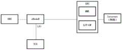
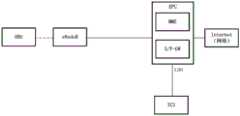
风险分析设备可以配置于交通控制单元,该TCU可以是一个部署在网络侧的服务器,该TCU与通信网络协同,利用网络的本地流量卸载(Local Break Out,LBO)能力或移动边缘计算(Mobile Edge Computing,MEC)能力接收来自第一设备和/或第二设备的状态数据等,通过数据的分析,按需申请网络资源应用不同发送策略发送数据给OBU,该发送策略可以是考虑到紧急程度、时延、可靠性等要求来设置。该TCU与第一设备之间的数据交互,可以利用网络的LBO或者MEC能力降低通信时延。The risk analysis device can be configured in the traffic control unit, and the TCU can be a server deployed on the network side. The TCU cooperates with the communication network and utilizes the local traffic offloading (Local Break Out, LBO) capability of the network or the Mobile Edge Computing (Mobile Edge Computing) capability. Computing, MEC) ability to receive status data from the first device and/or the second device, etc., through data analysis, apply for network resources as needed and apply different sending strategies to send data to the OBU. Delay, reliability and other requirements to set. In the data interaction between the TCU and the first device, the LBO or MEC capability of the network can be used to reduce the communication delay.
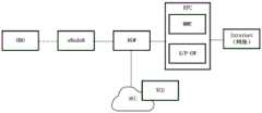
上述第一设备之间、第一设备与第二设备或第一设备与网络之间的通信均需要经过TCU,可以基于这种通信方式,实现车与车之间互相通告车辆状态数据的流程、车与车之间发送告警数据的流程、路与车、车与车之间共享感知流程、路侧设备(信号灯、标志牌)或中心服务单元发送交通环境数据给第一设备等流程。The communication between the above-mentioned first devices, between the first device and the second device, or between the first device and the network all need to go through the TCU. The process of sending alarm data between vehicles, the process of sharing perception between road and vehicle, and between vehicles, roadside equipment (signal lights, signs) or the central service unit sending traffic environment data to the first device and other processes.
另外,在上述实施环境中LTE-Uu是指基站与第一设备之间的接口,也是OBU与TCU之间通信的物理接入层接口。上述实施环境中,以4G LTE网络举例,可以是终端与2G、3G、4G、5G蜂窝网络之间接口。接口1是OBU与TCU之间通信的应用层接口。第一设备通过该接口1发送车辆状态数据、事件数据、感知数据给TCU。TCU通过该接口1发送风险数据、交通环境数据给第一设备。接口2是TCU与通信网络之间通信的接口,TCU需要利用网络的LBO能力、MEC能力降低通信时延,以实现实时性高的防碰撞类辅助驾驶应用。TCU会根据部署需要,连接不同的蜂窝网络的网元设备,不同的网元设备提供的接口是不同的,TCU需要适配这些接口,保障第一设备与TCU之间的通信时延、可靠性、带宽。接口3是TCU与路侧传感器之间通信的接口。接口4是TCU与信号灯、标志牌之间的接口。接口5是TCU与CSU之间的接口。In addition, in the above implementation environment, LTE-Uu refers to an interface between the base station and the first device, and is also a physical access layer interface for communication between the OBU and the TCU. In the above implementation environment, taking a 4G LTE network as an example, it may be an interface between a terminal and a 2G, 3G, 4G, and 5G cellular network.
在整个实施环境中,TCU还可以配置有如车辆状态数据库、感知数据库以及地理信息数据库等,下面一一介绍:In the whole implementation environment, TCU can also be configured with vehicle status database, perception database and geographic information database, etc., which are introduced one by one below:
车辆状态数据库,用于存储第一设备周期性上报的车辆状态数据,该车辆状态数据包括车辆的位置、速度、加速度、转向角度、角速度、角加速度、车辆尺寸、重量等数据。The vehicle state database is used to store the vehicle state data periodically reported by the first device, the vehicle state data including the vehicle's position, speed, acceleration, steering angle, angular velocity, angular acceleration, vehicle size, weight and other data.
传感器感知数据库,该传感器感知数据库用于存储路侧传感器以及车载传感器的感知数据,该感知数据可以是原始采集的视频流、雷达的点云数据或者是已经过分析的结构化的行人、车辆、障碍物的位置、速度、转向角度、尺寸大小数据,对于原始的视频流数据、雷达的点云数据需要先分析成可识别的结构化的行人、车辆、障碍物的位置、速度、转向角度、尺寸大小数据。The sensor perception database is used to store the perception data of roadside sensors and on-board sensors. The perception data can be the original collected video stream, the point cloud data of the radar, or the analyzed structured pedestrian, vehicle, The position, speed, steering angle, size data of obstacles, for the original video stream data, radar point cloud data need to be analyzed into identifiable structured pedestrians, vehicles, obstacles, position, speed, steering angle, size data.
地理信息数据库,用于存储车辆行驶线数据,车辆行驶线数据是车辆沿车道中心线行驶的地理位置轨迹图,可以从车道级的高精地图中获取或者通过录制车辆沿车道中心线行驶轨迹作为车辆行驶线数据。需要说明的是,该地理信息数据库还可以基于车辆行驶线的形式来存储路段的风险区域预范围数据,第二设备的管控区域。该地理信息数据库中还可以存储第二设备的设备位置,例如,第二设备的安装位置。The geographic information database is used to store vehicle travel line data. The vehicle travel line data is the geographic location trajectory map of the vehicle traveling along the lane center line, which can be obtained from the lane-level high-precision map or recorded by recording the vehicle travel trajectory along the lane center line as Vehicle travel line data. It should be noted that the geographic information database may also store the risk area pre-range data of the road section and the control area of the second device based on the vehicle travel line. The geographic information database may also store the device location of the second device, for example, the installation location of the second device.
上述内容主要分别描述了实施环境中设备的功能,而在第一设备与风险分析设备进行数据交互时,为了降低通信时延,以实现实时性高的防碰撞应用,需要结合蜂窝网络中各网元设备能提供的能力,有的网元设备能提供LBO能力、有的网元设备能提供MEC能力、有的网元设备的位置虽然很高,但它在部署中实际覆盖的范围小,到终端的时延也能满足实时性高应用的需求,所有这些都需要TCU适应不同网元设备的能力,以4G LTE网络,且风险分析设备配置于交通控制单元为例,TCU可以与之协同的方案有:The above content mainly describes the functions of the devices in the implementation environment, and when the first device and the risk analysis device perform data interaction, in order to reduce the communication delay and realize high real-time anti-collision applications, it is necessary to combine the various networks in the cellular network. The capabilities that element devices can provide. Some network element devices can provide LBO capabilities, and some network element devices can provide MEC capabilities. Although some network element devices are located at high locations, their actual coverage in deployment is small. The delay of the terminal can also meet the needs of high real-time applications. All of these require the ability of the TCU to adapt to different network element equipment. Taking the 4G LTE network and the risk analysis equipment configured in the traffic control unit as an example, the TCU can cooperate with it. The options are:
方案一:基于eNodeB LBO功能,其具体架构可以参见图1B。对于OBU发给TCU数据,eNodeB根据数据的目的地址是TCU,直接把数据发给本地配置的TCU,减少数据经核心网绕一圈回来的时延;对于TCU向OBU发送数据的情况,TCU直接把数据发给eNodeB,由eNodeB转发给OBU。为了保证信道通畅,TCU可以根据eNodeB开放的能力,根据业务需要预留空口资源,保证紧急告警数据能低时延、高可靠传输,普通等级数据有足够带宽。Scheme 1: Based on the eNodeB LBO function, its specific architecture can be seen in Figure 1B. For the data sent by the OBU to the TCU, the eNodeB directly sends the data to the locally configured TCU according to the destination address of the data, which reduces the time delay for the data to go back through the core network. The data is sent to the eNodeB, and the eNodeB forwards it to the OBU. To ensure a smooth channel, the TCU can reserve air interface resources according to the eNodeB's open capabilities and business needs to ensure that emergency alarm data can be transmitted with low latency and high reliability, and that ordinary-level data has sufficient bandwidth.
方案二:基于eNodeB MEC功能,其具体架构可以参见图1C。TCU以软件方式部署在MEC上,流程同方案一。Scheme 2: Based on the eNodeB MEC function, its specific architecture can be seen in Figure 1C. The TCU is deployed on the MEC in software, and the process is the same as that of
方案三:基于远端网关(Remote Gateway,RGW)的LBO功能,其具体架构可以参见图1D。RGW串接在eNode与EPC之间,可以把数据流量LBO到本地设备处理,也可以支持MEC。对于OBU向TCU发送数据的情况,eNodeB在转发给EPC途中,被RGW截获,RGW根据数据的目的地址为TCU,直接把数据发给TCU,减少数据经核心网绕一圈回来的时延;对于TCU向OBU发送数据的情况,TCU直接把数据发给RGW,由RGW转发给eNodeB,由eNodeB转发给OBU。为了保证信道通畅,TCU可以根据RGW开放的能力,根据业务需要预留空口资源,保证紧急告警数据能低时延、高可靠传输,普通等级数据有足够带宽。Scheme 3: Based on the LBO function of a remote gateway (Remote Gateway, RGW), the specific architecture of the LBO can be seen in FIG. 1D . The RGW is connected in series between the eNode and the EPC, and can transfer the data traffic LBO to the local device for processing, and can also support the MEC. For the case where the OBU sends data to the TCU, the eNodeB is intercepted by the RGW on the way of forwarding it to the EPC. The RGW directly sends the data to the TCU according to the destination address of the data to the TCU, reducing the delay of the data going back through the core network. When the TCU sends data to the OBU, the TCU directly sends the data to the RGW, the RGW forwards the data to the eNodeB, and the eNodeB forwards the data to the OBU. In order to ensure smooth channels, the TCU can reserve air interface resources according to the open capabilities of the RGW and business needs to ensure that emergency alarm data can be transmitted with low latency and high reliability, and that ordinary-level data has sufficient bandwidth.
方案四:基于RGW MEC功能,其具体架构可以参见图1E。TCU以软件方式部署在MEC上,流程同方案三。Scheme 4: Based on the RGW MEC function, its specific architecture can be seen in Figure 1E. The TCU is deployed on the MEC in the form of software, and the process is the same as that of Scheme 3.
方案五:基于EPC LBO功能。其具体架构可以参见图1F。对于OBU向TCU发送数据的情况,eNodeB会转发给演进型分组核心网(Evolved Packet Core,EPC),根据数据的目的地址,EPC把数据直接转发给TCU;对于TCU向OBU发送数据的情况,TCU先将数据发送给EPC,EPC转发给eNodeB,由eNodeB转发给OBU。为了保证信道通畅,TCU可以根据EPC开放的能力,根据业务需要预留空口资源,保证紧急告警数据能低时延、高可靠传输,普通等级数据有足够带宽。Option 5: Based on the EPC LBO function. Its specific architecture can be seen in Figure 1F. For the case where the OBU sends data to the TCU, the eNodeB will forward it to the Evolved Packet Core (EPC), and according to the destination address of the data, the EPC directly forwards the data to the TCU; for the case where the TCU sends data to the OBU, the TCU The data is first sent to the EPC, the EPC forwards it to the eNodeB, and the eNodeB forwards it to the OBU. To ensure a smooth channel, the TCU can reserve air interface resources according to the EPC's open capabilities and business needs to ensure that emergency alarm data can be transmitted with low latency and high reliability, and that ordinary-level data has sufficient bandwidth.
需要说明的是,在布设实施环境时,可以基于实际需求为道路布设不同类型的设备,还可以相应布设不同数据库来进行数据收集和数据存储,也即是,图1A至图1F所示的实施环境架构可以根据实际需求增加设备或者减少设备,或者改变设备之间的关联以及通信用接口等等,本公开实施例对此不做具体限定。It should be noted that when the implementation environment is deployed, different types of equipment can be deployed for the road based on actual needs, and different databases can also be correspondingly deployed for data collection and data storage, that is, the implementation shown in FIG. 1A to FIG. 1F The environment architecture may increase or decrease devices according to actual requirements, or change the association between devices and the interface for communication, etc., which is not specifically limited in this embodiment of the present disclosure.
图2是本公开实施例提供的一种风险分析设备的结构框图。例如,风险分析设备200可以被提供为一服务器。参照图2,风险分析设备200包括处理组件222,其进一步包括一个或多个处理器,以及由存储器232所代表的存储器资源,用于存储可由处理部件222的执行的指令,例如应用程序。存储器232中存储的应用程序可以包括一个或一个以上的每一个对应于一组指令的模块。此外,处理组件222被配置为执行指令,以执行下述图3、图6、图8、图10或图12所示任一个实施例中风险分析设备侧的驾驶风险分析及风险数据发送方法。FIG. 2 is a structural block diagram of a risk analysis device provided by an embodiment of the present disclosure. For example, the
风险分析设备200还可以包括一个电源组件222被配置为执行风险分析设备200的电源管理,一个有线或无线网络接口250被配置为将风险分析设备200连接到网络,和一个输入输出(I/O)接口258。风险分析设备200可以操作基于存储在存储器232的操作系统,例如Windows ServerTM,Mac OS XTM,UnixTM,LinuxTM,FreeBSDTM或类似。
在示例性实施例中,还提供了一种计算机可读存储介质,例如包括指令的存储器,上述指令可由风险分析设备中的处理器执行以完成下述实施例中的驾驶风险分析及数据发送方法。例如,所述计算机可读存储介质可以是ROM、随机存取存储器(RAM)、CD-ROM、磁带、软盘和光数据存储设备等。In an exemplary embodiment, a computer-readable storage medium is also provided, such as a memory including instructions, and the above-mentioned instructions can be executed by a processor in a risk analysis device to complete the driving risk analysis and data transmission method in the following embodiments . For example, the computer-readable storage medium may be ROM, random access memory (RAM), CD-ROM, magnetic tape, floppy disk, optical data storage device, and the like.
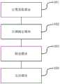
图3是本公开实施例提供的一种驾驶风险分析及风险数据发送方法的流程图,图4是基于实施环境的数据走向示意图。参见图3和图4,以风险分析设备为TCU为例进行说明,该方法包括:FIG. 3 is a flowchart of a driving risk analysis and risk data sending method provided by an embodiment of the present disclosure, and FIG. 4 is a schematic diagram of a data trend based on an implementation environment. Referring to FIG. 3 and FIG. 4 , taking the risk analysis device as a TCU as an example, the method includes:
301、第一设备向TCU发送第一设备的车辆状态数据。301. The first device sends vehicle status data of the first device to the TCU.
对于第一设备来说,第一设备可以周期性(如10Hz)的向TCU发送自身的车辆状态数据,以告知TCU自身的行驶状态,车辆状态数据包括车辆的位置、速度、加速度、转向角度、角速度、角加速度、车辆尺寸、重量数据等。For the first device, the first device may periodically (such as 10 Hz) send its own vehicle status data to the TCU to inform the TCU of its own driving status. The vehicle status data includes the vehicle's position, speed, acceleration, steering angle, Angular velocity, angular acceleration, vehicle dimensions, weight data, etc.
302、当TCU接收到该第一设备的车辆状态数据时,从该车辆状态数据中提取该第一设备的位置。302. When the TCU receives the vehicle state data of the first device, extract the location of the first device from the vehicle state data.
当TCU接收到该第一设备的车辆状态数据时,可以触发为该第一设备进行风险分析流程以便为该第一设备分析其行驶位置附近的风险情况,由于车辆状态数据本身即包含第一设备的位置,因此可以通过从中提取位置的方式来确定待进行风险分析的第一设备的位置。另外,TCU在接收到该车辆状态数据时,会将车辆状态数据存储至车辆状态数据库进行存储。When the TCU receives the vehicle state data of the first device, it can trigger the risk analysis process for the first device to analyze the risk situation near its driving position for the first device, because the vehicle state data itself includes the first device Therefore, the location of the first device to be subjected to risk analysis can be determined by extracting the location therefrom. In addition, when the TCU receives the vehicle state data, it stores the vehicle state data in the vehicle state database for storage.
由于第一设备配置在车辆上,因此,第一设备的位置即是第一设备所在车辆的位置。当然,在该流程中仅是以TCU接收到第一设备的车辆状态数据作为风险分析流程的触发条件,而在另一种可能实现方式中,该风险分析流程还可以是周期性触发,当到达第一设备的风险分析周期时,从车辆状态数据库中提取该第一设备的位置,该车辆状态数据库用于存储该风险分析设备的管控区域内所有第一设备的状态数据。例如,每个第一设备均可以设置有风险分析周期,使得TCU可以每当到达某个第一设备的风险分析周期时,可以为该第一设备启动其风险分析流程,以分析该第一设备附近所存在的风险。Since the first device is configured on the vehicle, the location of the first device is the location of the vehicle where the first device is located. Of course, in this process, only the vehicle state data of the first device received by the TCU is used as a triggering condition for the risk analysis process. In another possible implementation, the risk analysis process can also be triggered periodically. During the risk analysis period of the first device, the position of the first device is extracted from the vehicle state database, and the vehicle state database is used to store the state data of all the first devices in the control area of the risk analysis device. For example, each first device may be set with a risk analysis period, so that whenever the TCU reaches the risk analysis period of a certain first device, it can start its risk analysis process for the first device to analyze the first device Risks in the vicinity.
303、TCU基于该位置,确定该第一设备的车辆行驶线,所述第一设备对应的车辆行驶线包括所述第一设备所在的车辆行驶线、所述第一设备的相邻车辆行驶线以及所述第一设备的交叉行驶线中至少一条。303. The TCU determines the vehicle travel line of the first device based on the location, where the vehicle travel line corresponding to the first device includes the vehicle travel line where the first device is located and the vehicle travel line adjacent to the first device and at least one of the crossing lanes of the first device.
TCU可以根据该第一设备的位置,从地理信息数据库中查询该位置对应的车辆行驶线,也即是,该第一设备对应的车辆行驶线。According to the position of the first device, the TCU may query the vehicle travel line corresponding to the position from the geographic information database, that is, the vehicle travel line corresponding to the first device.
304、TCU将第一子区域、第二子区域和第三子区域中至少一个子区域,划分为该第一风险区域,该第一风险区域是指对该第一设备所在车辆的驾驶行为有影响的区域。304. The TCU divides at least one sub-area among the first sub-area, the second sub-area and the third sub-area into the first risk area, where the first risk area refers to the driving behavior of the vehicle where the first device is located. affected area.
基于第一设备的车辆行驶线,可以将该第一设备附近可能对第一设备所在车辆的驾驶行为有影响的区域划分为第一风险区域。有影响的区域一般会位于第一设备的四周,因此,在划分第一风险区域时,可以考虑该第一设备处于同一车辆行驶线上的前后一定范围,以及处于相邻行驶线的前后一定范围,如果目标位置接近交叉路口,还有交叉行驶线上来车的可能性,因此,可以考虑在交叉路口时的交叉行驶线上的一定范围,基于这种考虑,可以基于上述三种子区域进行具体划分:Based on the vehicle travel line of the first device, an area near the first device that may have an impact on the driving behavior of the vehicle where the first device is located may be divided into a first risk area. The affected area is generally located around the first device. Therefore, when dividing the first risk area, it can be considered that the first device is located in a certain range before and after the same vehicle driving line, and is located in a certain range before and after the adjacent driving line. , if the target position is close to the intersection, there is still the possibility of vehicles coming on the crossing line. Therefore, a certain range of the crossing line at the intersection can be considered. Based on this consideration, the above three sub-regions can be specifically divided. :
(1)第一子区域为与该第一设备处于同一车辆行驶线上,且位于该第一设备的前向和/或后向第一预设范围内的区域。需要说明的是,在划分第一风险区域时,第一设备的车辆行驶线上可以考虑前向的碰撞预警时长和/或后向的碰撞预警时长,并基于预设车速来划分,所划分的第一子区域可以是仅包括第一设备的前向的第一预设范围,也可以是仅包括第一设备的后向的第一预设范围,还可以是既包括前向也包括后向的第一预设范围。其中,前向的碰撞预警时长与后向的碰撞预警时长可以不同,例如,假设预设车速为120km/h时,前向的碰撞预警时长可以设置为5秒,后向的碰撞预警时长可以设置为3秒,则该第一预设范围为前向166米以内,后向100米以内。当然,上述举例是基于碰撞预警时长和预设车速来确定第一预设范围,而实际场景中,可以直接根据预设的前向和/或后向距离,来确定第一预设范围,而无需实时计算。其中,预设车速可以为该道路当前路段的平均车速或是限速等,不同路段可以对应于不同的限速,因此,对于不同路段来说,其所确定的子区域可以不同,本公开实施例对此不做具体限定。(1) The first sub-area is an area that is on the same vehicle driving line as the first device and is located within a first predetermined range in the forward and/or rearward direction of the first device. It should be noted that, when dividing the first risk area, the vehicle driving line of the first device may consider the forward collision warning duration and/or the backward collision warning duration, and divide it based on the preset vehicle speed. The first sub-area may be a first preset range that includes only the forward direction of the first device, or a first preset range that includes only the backward direction of the first device, or may include both the forward direction and the backward direction. the first preset range. The forward collision warning duration and the backward collision warning duration may be different. For example, if the preset vehicle speed is 120km/h, the forward collision warning duration can be set to 5 seconds, and the backward collision warning duration can be set to is 3 seconds, the first preset range is within 166 meters forward and within 100 meters backward. Of course, in the above example, the first preset range is determined based on the collision warning duration and the preset vehicle speed. In actual scenarios, the first preset range can be determined directly according to the preset forward and/or backward distances, while No real-time computation is required. The preset vehicle speed may be the average vehicle speed or the speed limit of the current section of the road, and different road sections may correspond to different speed limits. Therefore, for different road sections, the determined sub-regions may be different. This disclosure implements The example does not specifically limit this.
(2)第二子区域为处于该第一设备的相邻车辆行驶线上,且位于该第一设备的前向和/或后向第二预设范围内的区域。需要说明的是,在划分第一风险区域时,第一设备的相邻车辆行驶线上可以考虑换道辅助时盲点区域大小,所划分的第一子区域可以是仅包括相邻车辆行驶线上第一设备的前向的第二预设范围,也可以是仅包括相邻车辆行驶线上第一设备的后向的第二预设范围,还可以是既包括相邻车辆行驶线上前向也包括后向的第一预设范围。例如,可以将该第一设备的相邻车辆行驶线上前向100米、后向200米内区域作为第一风险区域.。(2) The second sub-area is an area located on the driving line of the adjacent vehicle of the first device and within a second predetermined range in the forward and/or rearward direction of the first device. It should be noted that when dividing the first risk area, the size of the blind spot area during lane change assistance may be considered on the driving line of the adjacent vehicle of the first device, and the divided first sub-area may only include the driving line of the adjacent vehicle. The second preset range of the forward direction of the first device may also be the second preset range that only includes the backward direction of the first device on the running line of the adjacent vehicle, or may include both the forward direction on the running line of the adjacent vehicle. A backward first preset range is also included. For example, an area within 100 meters forward and 200 meters backward on the driving line of adjacent vehicles of the first device may be taken as the first risk area.
(3)第三子区域为处于该第一设备的车辆行驶线的交叉行驶线上,且驶向交叉点的第三预设范围内的区域。需要说明的是,在划分第一风险区域时,可以考虑交叉路口碰撞预警的情况,该第三预设范围可以基于预设车速和碰撞预警时长来确定,例如,可以将5秒内可行驶到交叉点的范围作为第一风险区域。当然,该第三预设范围还可以基于预设距离来确定,可以将交叉行驶线上以交叉点为中心点、左右距离在200米以内的范围。(3) The third sub-area is an area that is on the crossing driving line of the vehicle driving line of the first device and is within a third preset range of the crossing point. It should be noted that, when dividing the first risk area, the collision warning situation at the intersection can be considered, and the third preset range can be determined based on the preset vehicle speed and the collision warning duration. The range of intersections serves as the first risk area. Of course, the third preset range may also be determined based on a preset distance, and may be a range within 200 meters between the left and right distances with the intersection as the center point on the crossing driving line.
需要说明的是,上述划分第一风险区域可以包括至少一个子区域,也即是,该第一风险区域可以包括上述任一个子区域,还可以包括至少两个子区域,当然,对于目标位置附近没有交叉行驶线的场景,则第一风险区域可以包括第一子区域或第二子区域,而对于目标位置是单车辆行驶线的场景,则第一风险区域可以包括第一子区域,还可以包括第三子区域,本公开实施例可以基于实际的道路情况确定第一风险区域,在此不做过多限定。另外,上述确定第一风险区域时所采用的碰撞预警时长等信息均可以根据路段进行配置,并将相应数据存储至地理信息数据库中,使得在进行区域划分时可以通过查询来使用,而在划分第一风险区域时,也是从地理信息数据库中提取出该第一风险区域的地理信息,以作为进一步筛选车辆状态数据的基础。It should be noted that the above-mentioned division of the first risk area may include at least one sub-area, that is, the first risk area may include any of the above-mentioned sub-areas, and may also include at least two sub-areas. In the scenario of crossing the driving line, the first risk area may include the first sub-area or the second sub-area, and for the scenario where the target location is a single-vehicle driving line, the first risk area may include the first sub-area, and may also include The third sub-area, the embodiment of the present disclosure may determine the first risk area based on actual road conditions, which is not limited here. In addition, the above-mentioned information such as the collision warning duration used in determining the first risk area can be configured according to the road section, and the corresponding data can be stored in the geographic information database, so that the area can be used by query when the area is divided. In the case of the first risk area, the geographic information of the first risk area is also extracted from the geographic information database to serve as a basis for further screening of vehicle state data.
例如,参见图5,提供了车辆行驶线的示意图。其中,主车代表待风险分析的第一设备所在车辆,则对于该主车来说,其自身的位置处于交叉点,则可以基于该主车的位置,将主车的车辆行驶线上前向和后向第一预设范围内的区域、主车相邻车辆行驶线上前向和后向第二预设范围内的区域以及主车的交叉行驶线上第三预设范围内的区域划分为第一风险区域。For example, referring to Figure 5, a schematic diagram of a vehicle travel line is provided. Among them, the host vehicle represents the vehicle where the first device to be risk analysis is located, and for the host vehicle, its own position is at the intersection, and the vehicle driving line of the host vehicle can be moved forward based on the position of the host vehicle. and backward, the area within the first preset range, the area within the second preset range forward and backward on the driving line of the adjacent vehicle of the host vehicle, and the area within the third preset range on the cross traveling line of the host vehicle the first risk area.
305、对车辆状态数据库的车辆状态数据按该第一风险区域进行筛选,将位置处于该第一风险区域的车辆状态数据作为风险数据。305. Filter the vehicle state data in the vehicle state database according to the first risk area, and use the vehicle state data located in the first risk area as the risk data.
由于已经确定的第一风险区域内的车辆是会对该第一设备所在车辆的驾驶行为造成影响的车辆,因此,可以通过基于第一风险区域的地理信息来将这些车辆的车辆状态数据筛选出来,则可以避免由于广播或组播式数据发送所造成的资源浪费的情况,且,由于大大降低了数据发送量,也可以避免数据的延时。该筛选过程可以是基于筛选得到的第一风险区域的地理信息,从车辆状态数据库中将位置位于该第一风险区域内的车辆状态数据筛选出来。Since the vehicles in the determined first risk area are vehicles that will affect the driving behavior of the vehicle where the first device is located, the vehicle state data of these vehicles can be filtered out based on the geographic information of the first risk area , the waste of resources caused by broadcast or multicast data transmission can be avoided, and the data delay can also be avoided because the amount of data transmission is greatly reduced. The screening process may be based on the geographic information of the first risk region obtained by screening, and screening out the vehicle status data located in the first risk region from the vehicle status database.
上述步骤305所提供的筛选过程实际上是对该第一风险区域进行数据分析,得到风险数据的一种具体实现方式,该风险数据的时间戳可以为风险数据的原时间戳。在另一种可能实现方式中,由于数据库中所存储的是多个设备最近一次所发送的车辆状态数据,因此,可以对筛选得到的数据基于当前时间戳和车辆状态数据的时间戳进行预测,从而得到当前时刻的预测数据。该过程具体可以包括:对车辆状态数据库的车辆状态数据按该第一风险区域进行筛选,得到位置处于该第一风险区域的车辆状态数据,基于该位置处于该第一风险区域的车辆状态数据进行预测,得到该风险数据。此时,该风险数据的时间戳可以为当前时间的时间戳。这种预测数据可以让第一设备直接使用,而不必根据当前时间和数据的时差来进行预测。The screening process provided in the above step 305 is actually a specific implementation manner of performing data analysis on the first risk area to obtain risk data, and the time stamp of the risk data may be the original time stamp of the risk data. In another possible implementation manner, since the database stores the vehicle status data sent by multiple devices most recently, the filtered data can be predicted based on the current timestamp and the timestamp of the vehicle status data. Thereby, the forecast data at the current moment is obtained. The process may specifically include: screening the vehicle state data in the vehicle state database according to the first risk area to obtain the vehicle state data whose position is in the first risk area, and based on the vehicle state data whose position is in the first risk area. Predict and get the risk data. At this time, the timestamp of the risk data may be the timestamp of the current time. Such prediction data can be directly used by the first device without making predictions based on the current time and the time difference of the data.
306、当达到第一周期时,将紧急程度大于或等于预设高级别的风险数据发送给该第一设备;当达到第二周期时,将紧急程度大于或等于该预设中级别的风险数据发送给该第一设备,当达到第三周期时,将所述风险数据发送给所述第一设备,其中,所述第一周期的时长跨度小于所述第二周期的时长跨度、第二周期的时长跨度小于所述第三周期的时长跨度。306. When the first period is reached, send the risk data with the emergency degree greater than or equal to the preset high level to the first device; when the second period is reached, send the risk data with the emergency degree greater than or equal to the preset medium level Send to the first device, and when the third cycle is reached, send the risk data to the first device, wherein the time span of the first cycle is smaller than the time span of the second cycle, the second cycle The duration span of is smaller than the duration span of the third period.
其中,紧急程度可以按照潜在发生碰撞的紧急性来衡量。该紧急程度可以按照潜在发生碰撞的时长来划分,可以划分不同的时长区间,每个时长区间对应于一个紧急程度级别,其潜在发生碰撞的时长越短,紧急程度越高。当然,该紧急程度还可以按照潜在发生碰撞的距离来划分,可以划分不同的距离区间,每个距离区间对应于一个紧急程度级别,其潜在发生碰撞的距离越短,紧急程度越高,当然,紧急程度还可以结合碰撞时长和碰撞距离来确定,或是基于其他因素确定,本公开实施例对此不做限定。Among them, the urgency can be measured according to the urgency of a potential collision. The urgency may be divided according to the duration of the potential collision, and may be divided into different duration intervals, each duration interval corresponds to an emergency level, and the shorter the duration of the potential collision, the higher the urgency. Of course, the urgency can also be divided according to the distance of potential collision. Different distance intervals can be divided. Each distance interval corresponds to an urgency level. The shorter the distance of potential collision, the higher the urgency. Of course, The degree of urgency may also be determined in combination with the collision duration and the collision distance, or determined based on other factors, which are not limited in this embodiment of the present disclosure.
上述步骤306至307是该将该风险数据发送至第一设备的过程。对于第一设备来说,其急需的风险数据应该是具有较大碰撞可能性的设备的状态数据,因此,为了避免对传输资源的过度占用,则可以根据风险数据的紧急程度设置不同紧急程度的发送周期,也即是,只在每隔第一周期发送紧急程度大于或等于预设高级别的风险数据,每隔第二周期发送紧急程度大于或等于预设中级别的风险数据,例如,第一周期可以为100ms,第二周期可以为200ms。且为了保证风险通知的数据完整性,还可以在达到第三周期时,将风险数据中的所有数据发送至第一设备。其中,预设高级别和预设中级别可以由风险分析设备预设置或根据该第一设备的请求确定。The above steps 306 to 307 are the process of sending the risk data to the first device. For the first device, the urgently needed risk data should be the status data of the device with a high possibility of collision. Therefore, in order to avoid excessive occupation of transmission resources, different urgency levels can be set according to the urgency of the risk data. Sending cycle, that is, only sending risk data with an urgency level greater than or equal to a preset high level every first cycle, and sending risk data with an emergency level greater than or equal to a preset medium level every second cycle, for example, the first One period may be 100ms, and the second period may be 200ms. And in order to ensure the data integrity of the risk notification, all data in the risk data may also be sent to the first device when the third period is reached. Wherein, the preset high level and the preset medium level may be preset by the risk analysis device or determined according to the request of the first device.
在本公开实施例中,不同紧急程度对应的发送策略由风险分析设备预配置或根据该第一设备的请求确定。例如,有的第一设备为节省带宽,它所要求的风险数据中仅包含潜在发生碰撞最紧急的车辆信息;而有的第一设备风险意识较强,它所要求的风险数据是处于风险区域所有车辆信息;当然也可以采用综合平衡通信带宽占用与信息实时性、完整性矛盾的方式,如:潜在发生碰撞最紧急的车辆信息,数据量也最小,绝大部分时间没有这类数据,可以即时发送,对于潜在发生碰撞次紧急的车辆信息,可以200ms周期发送,完整风险数据量大,可以1s周期发送。In this embodiment of the present disclosure, sending policies corresponding to different urgency levels are preconfigured by the risk analysis device or determined according to a request of the first device. For example, in order to save bandwidth, the risk data required by some first devices only includes the information of the most urgent vehicles that are potentially involved in a collision; while some first devices have strong risk awareness, and the risk data it requires is in the risk area. All vehicle information; of course, it is also possible to comprehensively balance the contradiction between the occupancy of communication bandwidth and the real-time and integrity of information. For example, the most urgent vehicle information in a potential collision has the smallest amount of data. There is no such data most of the time. Immediately sent, for potential collision and secondary emergency vehicle information, it can be sent in a 200ms cycle, and the complete risk data volume is large and can be sent in a 1s cycle.
相应地,上述步骤306和307还可以采用其他实现方式,例如,在一种可能实现方式中,为了进一步降低数据发送量,且提高风险数据的实时性,可以采用在接收到第一设备的车辆状态数据时马上将筛选到的紧急程度较高的风险数据发送给第一设备,而不是将所有风险数据一次性发送,而为了数据完整性,则可以在达到第二周期时才发送风险数据中的所有数据。在又一种可能实现方式中,当到达该第一设备的风险分析周期时,还可以不区分紧急程度,将该风险数据发送至第一设备。在又一种可能实现方式中,为了降低数据量,还可以仅将紧急程度大于或等于预设高级别的风险数据发送给该第一设备。当然,也可以将紧急程度最大的风险数据发送给第一设备,其余数据在达到第二周期时再发送,本公开实施例对具体采用上述哪种实现方式不做具体限定,随系统需求不同,可以相应对实现方式进行调整。Correspondingly, the above steps 306 and 307 may also be implemented in other manners. For example, in a possible implementation manner, in order to further reduce the amount of data sent and improve the real-time nature of risk data, the vehicle that receives the first device may be Instead of sending all risk data at one time, for data integrity, the risk data can be sent only when the second cycle is reached. of all data. In another possible implementation manner, when the risk analysis period of the first device is reached, the risk data may be sent to the first device without distinguishing the degree of urgency. In another possible implementation manner, in order to reduce the amount of data, only risk data with an emergency degree greater than or equal to a preset high level may be sent to the first device. Of course, the risk data with the greatest urgency may also be sent to the first device, and the rest of the data will be sent when the second cycle is reached. This embodiment of the present disclosure does not specifically limit which of the above-mentioned implementation methods is adopted. It varies with system requirements. The implementation can be adjusted accordingly.
上述步骤306主要是从紧急程度的角度来描述先发送哪些数据后发送哪些数据,然而,对于风险数据来说,其具体在发送时,还可以采用下述任一种发送方式:第一种发送方式、当该风险数据包括两个或两个以上设备的状态数据时,将该风险数据打包成一个数据包,向该第一设备发送该数据包。第二种发送方式、当该风险数据包括两个或两个以上设备的状态数据时,将每个状态数据打包成一个数据包,得到多个数据包,依次向该第一设备发送该多个数据包。这是一种兼容车与车、车与路直接通信的方式,站在第一设备的角度来看,第一设备直接接收其它车辆状态数据与经过TCU转发后的接收是相同的,但是其数据量大大减少。进一步地,在依次向第一设备发送该多个数据包时,也可以按照紧急程度的级别从大到小的顺序,向该第一设备发送该多个数据包。The above-mentioned step 306 mainly describes which data is sent first and then which data is sent from the perspective of urgency. However, for risk data, when it is sent, any one of the following sending methods can also be used: the first sending method, when the risk data includes the state data of two or more devices, the risk data is packaged into a data packet, and the data packet is sent to the first device. In the second sending method, when the risk data includes the status data of two or more devices, each status data is packaged into a data packet to obtain multiple data packets, and the multiple data packets are sent to the first device in turn. data pack. This is a method that is compatible with vehicle-to-vehicle, vehicle-to-road direct communication. From the perspective of the first device, the first device directly receives other vehicle status data is the same as the one that is forwarded by the TCU, but its data The amount is greatly reduced. Further, when the multiple data packets are sequentially sent to the first device, the multiple data packets may also be sent to the first device in descending order of the level of urgency.
307、第一设备在接收到风险数据时,根据风险数据进行驾驶辅助提示。307. When receiving the risk data, the first device performs a driving assistance prompt according to the risk data.
该第一设备可以基于风险数据实现辅助驾驶,例如,碰撞预警,以该碰撞预警具体为前向碰撞预警为例,第一设备从风险数据中筛选出第一设备前方的车辆信息,计算它们与第一设备潜在发生碰撞的时长,如果该时长小于第一设备所配置的碰撞预警时长,则对驾驶员进行前向碰撞预警。当然,该辅助驾驶提示还可以包括其他预警,例如后向预警、侧方预警、路况提示等等,本公开实施例对此不做具体限定。The first device can implement assisted driving based on risk data, for example, collision warning. Taking the collision warning as a forward collision warning as an example, the first device filters out vehicle information in front of the first device from the risk data, and calculates the difference between them and the forward collision warning. The duration of the potential collision of the first device, if the duration is less than the collision warning duration configured by the first device, a forward collision warning is issued to the driver. Of course, the assisted driving prompt may also include other warnings, such as backward warning, side warning, road condition warning, etc., which are not specifically limited in the embodiment of the present disclosure.
需要说明的是,第一设备与TCU之间的数据交互可以基于蜂窝网络中的基站(如eNodeB)进行,也即是,该步骤301实际上是第一设备通过与基站之间的接口向TCU发送车辆状态数据,由基站在接收到该车辆状态数据后,根据该车辆状态数据的目的地址,通过基站的LBO能力转发给TCU。而相应地,步骤306中的数据发送过程,也可以是由TCU获取缓存的第一设备位置、第一设备所属基站地址,并通过基站的LBO能力转发给第一设备。当然,该数据交互过程仅是基于通过基站LBO进行为例进行说明,在实际场景中,还可以采用其他网元设备的LBO能力或MEC能力实现,该网元设备为基站、RGW或EPC,上述利用LBO能力或MEC能力进行通信的方式,可以大大降低通信时延。It should be noted that the data interaction between the first device and the TCU can be performed based on a base station (such as an eNodeB) in the cellular network, that is, in step 301, the first device actually communicates with the TCU through the interface between the first device and the base station. The vehicle status data is sent, and after receiving the vehicle status data, the base station forwards it to the TCU through the LBO capability of the base station according to the destination address of the vehicle status data. Correspondingly, in the data sending process in step 306, the TCU may also acquire the cached location of the first device and the address of the base station to which the first device belongs, and forward it to the first device through the LBO capability of the base station. Of course, the data exchange process is only described based on the base station LBO as an example. In actual scenarios, the LBO capability or MEC capability of other network element equipment can also be used. The network element equipment is a base station, RGW or EPC. By using the LBO capability or the MEC capability to communicate, the communication delay can be greatly reduced.
本公开实施例提供的方法,通过风险分析设备实时为第一设备所在车辆筛选其附近的风险数据,由于能够通过筛选降低风险数据的数据量,大大减少了数据发送的时延,并且还能够降低设备之间互相通告车辆状态数据的带宽要求,以及降低对空口资源调度频次要求,提高了通信性能,同时能够使得第一设备灵活的感知附近车辆的状态,以达到辅助驾驶的目的。进一步地,还通过对风险数据以紧急程度进行分类,并基于紧急程度采取不同的发送策略,能够提高紧急的风险数据的及时性,也能够保证相对不紧急的风险数据的正常发送。In the method provided by the embodiment of the present disclosure, the risk analysis device is used to screen the risk data in the vicinity of the vehicle where the first device is located in real time. Since the data volume of the risk data can be reduced by screening, the delay in data transmission is greatly reduced, and the The devices notify each other of the bandwidth requirements of vehicle status data, and reduce the frequency requirements for air interface resource scheduling, improve communication performance, and enable the first device to flexibly perceive the status of nearby vehicles to achieve the purpose of assisting driving. Further, by classifying the risk data according to the urgency, and adopting different sending strategies based on the urgency, the timeliness of the urgent risk data can be improved, and the normal sending of the relatively non-urgent risk data can also be ensured.
上述实施例仅以筛选的是车辆状态数据为例进行说明,而实际上,由于道路上还可以布设有路侧传感器,车辆自身还可以配置有车载传感器,因此,在实际场景中,还可以结合车辆状态数据和传感器感知数据库的感知数据进行筛选,以更准确的获知车辆、行人、障碍物的状态,从而达到更好的辅助驾驶目的,下面,结合图6和图7,对该基于车辆状态数据和感知数据的数据发送过程进行说明:The above embodiment only takes the vehicle status data as an example for description. In fact, since roadside sensors can also be arranged on the road, and the vehicle itself can also be equipped with on-board sensors, in actual scenarios, it can also be combined with The vehicle status data and the perception data of the sensor perception database are screened to more accurately know the status of vehicles, pedestrians, and obstacles, so as to achieve better assisted driving purposes. The data sending process of data and perception data is explained:
601、第一设备向TCU发送第一设备的车辆状态数据。601. The first device sends vehicle status data of the first device to the TCU.
602、当TCU接收到该第一设备的车辆状态数据时,从该车辆状态数据中提取该第一设备的位置。602. When the TCU receives the vehicle state data of the first device, extract the location of the first device from the vehicle state data.
603、TCU基于该位置,确定该第一设备对应的车辆行驶线。603. Based on the location, the TCU determines a vehicle travel line corresponding to the first device.
604、TCU将第一子区域、第二子区域和第三子区域中至少一个子区域,划分为该第一风险区域,该第一风险区域是指对第一设备所在车辆的驾驶行为有影响的区域。604. The TCU divides at least one sub-area among the first sub-area, the second sub-area, and the third sub-area into the first risk area, where the first risk area refers to an impact on the driving behavior of the vehicle where the first device is located. Area.
上述步骤601-604与步骤301至304同理,在此不做赘述。The above steps 601 to 604 are the same as the steps 301 to 304, and are not repeated here.
605、对车辆状态数据库的车辆状态数据和传感器感知数据库的感知数据按所述第一风险区域进行筛选,将位置处于所述第一风险区域的车辆状态数据和感知数据作为风险数据。605. Screen the vehicle state data in the vehicle state database and the perception data in the sensor perception database according to the first risk area, and use the vehicle state data and perception data located in the first risk area as risk data.
其中,感知数据是风险数据中的一种,用于指示传感器的感知区域内的车辆、行人和障碍物的状态,因此,结合车辆状态数据和感知数据,能够进一步提高风险数据的准确性和全面性。该筛选过程可以是基于筛选得到的第一风险区域的地理信息,从车辆状态数据库中将位置位于该第一风险区域内的车辆状态数据筛选出来,并从传感器感知数据库中将位置处于该第一风险区域内的感知数据筛选出来。当然,上述采用任一筛选顺序均可以,可采用上述描述顺序进行筛选,也可以颠倒顺序进行筛选,还可以同时进行筛选,以提高数据筛选效率。Among them, perception data is a kind of risk data, which is used to indicate the state of vehicles, pedestrians and obstacles in the sensor's perception area. Therefore, combining vehicle state data and perception data can further improve the accuracy and comprehensiveness of risk data. sex. The screening process may be based on the geographic information of the first risk area obtained by screening, screening out the vehicle status data located in the first risk area from the vehicle status database, and selecting the position in the first risk area from the sensor perception database. Perception data within the risk area is filtered out. Of course, any one of the above screening sequences can be used, and the above described order can be used for screening, or the order can be reversed, or the screening can be performed at the same time, so as to improve the data screening efficiency.
当然,由于感知数据也是周期性获取,因此,也可以基于感知数据进行预测,从而得到预测数据。相应地,该数据分析过程包括:对车辆状态数据库的车辆状态数据和传感器感知数据库的感知数据按所述第一风险区域进行筛选,得到位置处于所述第一风险区域的车辆状态数据和感知数据,基于所述位置处于所述第一风险区域的车辆状态数据和感知数据进行预测,得到所述风险数据。Of course, since the perceptual data is also acquired periodically, prediction based on the perceptual data can also be performed to obtain the predicted data. Correspondingly, the data analysis process includes: screening the vehicle state data in the vehicle state database and the perception data in the sensor perception database according to the first risk area to obtain vehicle state data and perception data located in the first risk area. , and perform prediction based on vehicle state data and perception data where the position is in the first risk area to obtain the risk data.
606、当达到第一周期时,将紧急程度大于或等于预设高级别的风险数据发送给该第一设备;当达到第二周期时,将紧急程度大于或等于该预设中级别的风险数据发送给该第一设备,当达到第三周期时,将所述风险数据发送给所述第一设备,其中,所述第一周期的时长跨度小于所述第二周期的时长跨度、第二周期的时长跨度小于所述第三周期的时长跨度。606. When the first cycle is reached, send the risk data with the emergency level greater than or equal to the preset high level to the first device; when the second cycle is reached, send the risk data with the emergency level greater than or equal to the preset medium level Send to the first device, and when the third cycle is reached, send the risk data to the first device, wherein the time span of the first cycle is smaller than the time span of the second cycle, the second cycle The duration span of is smaller than the duration span of the third period.
607、第一设备在接收到风险数据时,根据风险数据进行驾驶辅助提示。607. When receiving the risk data, the first device performs a driving assistance prompt according to the risk data.
该步骤606和607与步骤306和307同理,在此不做赘述。The steps 606 and 607 are the same as the steps 306 and 307, and are not repeated here.
需要说明的是,在进行数据分析时,还可以仅根据传感器感知数据库进行,也即是风险数据仅包括感知的车辆、行人和障碍物的状态数据,此时,也能够达到降低数据量以及感知附近车辆状态的目的。It should be noted that when performing data analysis, it can also be performed only based on the sensor perception database, that is, the risk data only includes the perceived status data of vehicles, pedestrians and obstacles. At this time, it can also reduce the amount of data and the perception of The purpose of the status of nearby vehicles.
本公开实施例提供的方法,通过风险分析设备实时为第一设备所在车辆筛选其附近的风险数据,由于能够通过筛选降低风险数据的数据量,因此,大大减少了数据发送的时延,并且还能够降低设备之间互相通告车辆状态数据的带宽要求,以及降低对空口资源调度频次要求,提高了通信性能,同时能够使得第一设备灵活的感知附近车辆、行人、障碍物的状态,以达到辅助驾驶的目的。进一步地,还通过对风险数据以紧急程度进行分类,并基于紧急程度采取不同的发送策略,能够提高紧急的风险数据的及时性,也能够保证相对不紧急的风险数据的正常发送。更进一步地,由于结合了路侧传感器所获取的感知数据,能够提高风险数据的准确性和全面性,大大提高了辅助驾驶提示的准确性,对道路安全有着巨大的贡献。In the method provided by the embodiments of the present disclosure, the risk analysis device is used to screen the risk data in the vicinity of the vehicle where the first device is located in real time. Since the data volume of the risk data can be reduced through screening, the delay in data transmission is greatly reduced, and the It can reduce the bandwidth requirements for mutual notification of vehicle status data between devices, and reduce the frequency requirements for air interface resource scheduling, improve communication performance, and enable the first device to flexibly perceive the status of nearby vehicles, pedestrians, and obstacles to achieve assistance. purpose of driving. Further, by classifying the risk data according to the urgency, and adopting different sending strategies based on the urgency, the timeliness of the urgent risk data can be improved, and the normal sending of the relatively non-urgent risk data can also be ensured. Furthermore, due to the combination of perception data obtained by roadside sensors, the accuracy and comprehensiveness of risk data can be improved, and the accuracy of assisted driving prompts can be greatly improved, making a great contribution to road safety.
上述实施例仅以筛选的是车辆状态数据和感知数据为例进行说明,而实际上,由于道路上还可能发生一些车辆的告警事件或信号灯变化等事件,因此,在实际场景中,还可以结合车辆状态数据、感知数据以及交通环境数据进行筛选,以更准确的获知车辆、行人、障碍物的状态以及交通状况,从而达到更好的辅助驾驶目的,下面,结合图8和图9,对该驾驶风险分析及风险数据发送过程进行说明:The above embodiment only takes the vehicle status data and perception data as an example for description. In fact, since some vehicle warning events or signal light changes may also occur on the road, in actual scenarios, it is also possible to combine The vehicle status data, perception data and traffic environment data are screened to more accurately know the status of vehicles, pedestrians, obstacles and traffic conditions, so as to achieve better driving assistance purposes. The driving risk analysis and risk data sending process are explained:
801、第一设备向TCU发送第一设备的车辆状态数据。801. The first device sends vehicle status data of the first device to the TCU.
802、当TCU接收到该第一设备的车辆状态数据时,从该车辆状态数据中提取该第一设备的位置。802. When the TCU receives the vehicle state data of the first device, extract the location of the first device from the vehicle state data.
803、TCU基于该位置,确定该第一设备的车辆行驶线。803. The TCU determines, based on the location, a vehicle travel line of the first device.
804、TCU将第一子区域、第二子区域和第三子区域中至少一个子区域,划分为该第一风险区域,该第一风险区域是指对该第一设备所在车辆的驾驶行为有影响的区域。804. The TCU divides at least one sub-area among the first sub-area, the second sub-area and the third sub-area into the first risk area, where the first risk area refers to the driving behavior of the vehicle where the first device is located. affected area.
上述步骤801-804与步骤301至304同理,在此不做赘述。The above steps 801 to 804 are the same as the steps 301 to 304, and are not repeated here.
805、对车辆状态数据库的车辆状态数据和传感器感知数据库的感知数据按该第一风险区域进行筛选,将位置处于该第一风险区域的车辆状态数据和感知数据作为风险数据。805. Screen the vehicle state data in the vehicle state database and the perception data in the sensor perception database according to the first risk area, and use the vehicle state data and perception data located in the first risk area as risk data.
806、对交通环境数据库的交通环境数据按该第一风险区域进行筛选,将位置处于该第一风险区域的交通环境数据作为风险数据。806. Filter the traffic environment data in the traffic environment database according to the first risk area, and use the traffic environment data located in the first risk area as the risk data.
其中,交通环境数据是风险数据中的一种,用于指示与交通环境变化相关的车辆行驶状态变化、信号灯或标志牌以及路况变化等等。因此,结合车辆状态数据、感知数据以及交通环境数据,能够进一步提高风险数据的准确性和全面性。该筛选过程可以是基于筛选得到的第一风险区域的地理信息,从车辆状态数据库中将位置位于该第一风险区域内的车辆状态数据筛选出来,并从传感器感知数据库中将位置处于该第一风险区域内的感知数据筛选出来,再从交通环境数据库中将位置处于该第一风险区域内的交通环境数据筛选出来。当然,上述采用任一筛选顺序均可以,可采用上述描述顺序进行筛选,也可以打乱顺序进行筛选,还可以同时进行筛选,以提高数据筛选效率。Among them, the traffic environment data is a kind of risk data, which is used to indicate the change of the driving state of the vehicle, the signal light or the sign, the change of the road condition, etc. related to the change of the traffic environment. Therefore, combining vehicle state data, perception data, and traffic environment data can further improve the accuracy and comprehensiveness of risk data. The screening process may be based on the geographic information of the first risk area obtained by screening, screening out the vehicle status data located in the first risk area from the vehicle status database, and selecting the position in the first risk area from the sensor perception database. The perception data in the risk area is screened out, and then the traffic environment data located in the first risk area is screened out from the traffic environment database. Of course, any of the above screening sequences can be used, and the above described order can be used for screening, or the order can be disrupted for screening, or screening can be performed simultaneously to improve data screening efficiency.
807、当达到第一周期时,将紧急程度大于或等于预设高级别的风险数据发送给该第一设备;当达到第二周期时,将紧急程度大于或等于该预设中级别的风险数据发送给该第一设备,当达到第三周期时,将所述风险数据发送给所述第一设备,其中,所述第一周期的时长跨度小于所述第二周期的时长跨度、第二周期的时长跨度小于所述第三周期的时长跨度。807. When the first period is reached, send the risk data with the emergency degree greater than or equal to the preset high level to the first device; when the second period is reached, send the risk data with the emergency degree greater than or equal to the preset medium level Send to the first device, and when the third cycle is reached, send the risk data to the first device, wherein the time span of the first cycle is smaller than the time span of the second cycle, the second cycle The duration span of is smaller than the duration span of the third period.
808、第一设备在接收到风险数据时,根据风险数据进行驾驶辅助提示。808. When receiving the risk data, the first device performs a driving assistance prompt according to the risk data.
该步骤807和808与步骤306和307同理,在此不做赘述。The steps 807 and 808 are the same as the steps 306 and 307, and are not repeated here.
需要说明的是,在进行数据分析时,还可以基于车辆状态数据库和交通环境数据库进行,而不基于传感器感知数据库,也能够达到降低数据量以及感知附近车辆状态的目的。It should be noted that the data analysis can also be performed based on the vehicle state database and the traffic environment database instead of the sensor perception database, which can also achieve the purpose of reducing the amount of data and sensing the state of nearby vehicles.
本公开实施例提供的方法,通过风险分析设备实时为第一设备所在车辆筛选其附近的风险数据,由于能够通过筛选降低风险数据的数据量,因此,不仅降低设备之间互相通告车辆状态数据的带宽要求,又能够使得第一设备灵活的感知附近车辆、行人、障碍物的状态,以达到辅助驾驶的目的。进一步地,还通过对风险数据以紧急程度进行分类,并基于紧急程度采取不同的发送策略,能够提高紧急的风险数据的及时性,也能够保证相对不紧急的风险数据的正常发送。更进一步地,由于结合了交通环境数据,能够提高风险数据的准确性和全面性,大大提高了辅助驾驶提示的准确性,对道路安全有着巨大的贡献。In the method provided by the embodiment of the present disclosure, the risk analysis device is used to screen the risk data in the vicinity of the vehicle where the first device is located in real time. Since the data volume of the risk data can be reduced through screening, it not only reduces the need for devices to notify each other of vehicle status data The bandwidth requirement also enables the first device to flexibly perceive the status of nearby vehicles, pedestrians, and obstacles, so as to achieve the purpose of assisting driving. Further, by classifying the risk data according to the urgency, and adopting different sending strategies based on the urgency, the timeliness of the urgent risk data can be improved, and the normal sending of the relatively non-urgent risk data can also be ensured. Furthermore, due to the combination of traffic environment data, the accuracy and comprehensiveness of risk data can be improved, and the accuracy of assisted driving prompts can be greatly improved, making a great contribution to road safety.
上述实施例仅以对某一设备进行风险分析为例进行说明,而实际上,在数据发送时还涉及到交通环境数据的发送,该交通环境数据可以用于通知一些对驾驶行为有影响的事件,例如道路上可能发生一些车辆的紧急事件,因此,在实际场景中,可以针对紧急事件进行风险分析,筛选出受到紧急事件影响的车辆,从而对多个车辆进行风险提示,达到更好的辅助驾驶目的,下面,结合图10和图11,对该驾驶风险分析及风险数据发送过程进行说明:The above embodiment only takes the risk analysis of a certain device as an example for description, but in fact, the data transmission also involves the transmission of traffic environment data, and the traffic environment data can be used to notify some events that have an impact on driving behavior. , for example, some emergency incidents of vehicles may occur on the road. Therefore, in actual scenarios, risk analysis can be carried out for emergency incidents, and vehicles affected by emergency incidents can be screened out, so as to provide risk prompts for multiple vehicles to achieve better assistance. For the purpose of driving, the following describes the driving risk analysis and risk data sending process with reference to FIG. 10 and FIG. 11 :
1001、第一设备向TCU发送交通环境数据。1001. The first device sends traffic environment data to the TCU.
当第一设备为OBU等车用设备时,如果车辆发生紧急制动、异常、失控等情况,会向TCU发送交通环境数据(还可以称为事件数据或告警数据),以使得TCU能够分析出受影响的区域,并将交通环境数据发送给受影响的区域内的其他第一设备。其中,该第一设备向TCU发送交通环境数据可以通过蜂窝网络(eNodeB)周期性(如5Hz)发送,也即是,每到达预设周期,则发送一次该交通环境数据。其中,每次所发送的交通环境数据的事件内容可以相同,而每次发送的交通环境数据中包含的位置相关数据和时间戳不同,以用于标识当前的位置和发送时间,该周期性发送可以保证交通环境数据的有效传达,也能够体现车辆位置的变化。When the first device is a vehicle equipment such as OBU, if the vehicle experiences emergency braking, abnormality, loss of control, etc., it will send traffic environment data (also referred to as event data or alarm data) to the TCU, so that the TCU can analyze the affected area, and send traffic environment data to other first devices in the affected area. The traffic environment data sent by the first device to the TCU may be sent periodically (eg, 5 Hz) through a cellular network (eNodeB), that is, the traffic environment data is sent once every preset period. The event content of the traffic environment data sent each time may be the same, and the location-related data and time stamps contained in the traffic environment data sent each time may be different, so as to identify the current location and the sending time. The periodic sending It can ensure the effective communication of traffic environment data, and can also reflect the change of vehicle position.
当然,在发送时还可以对发送次数进行限制,也即是,当交通环境数据的发送次数达到预设次数时,则可以停止发送,以便在达到事件通知目的的同时,避免对传输资源的过度占用。Of course, the number of transmissions can also be limited during transmission, that is, when the number of transmissions of the traffic environment data reaches the preset number, the transmission can be stopped, so as to avoid excessive transmission resources while achieving the purpose of event notification. occupied.
1002、当TCU接收到该第一设备的交通环境数据时,从该交通环境数据中提取该第一设备的位置作为目标位置。1002. When the TCU receives the traffic environment data of the first device, extract the location of the first device from the traffic environment data as a target location.
该步骤1002是获取目标位置的过程,该目标位置是指待进行风险分析的交通环境数据产生的位置,由于该目标位置的交通环境发生了变化,因此,需要基于该目标位置来确定第二风险区域。This step 1002 is the process of acquiring the target position, the target position refers to the position where the traffic environment data to be subjected to risk analysis is generated. Since the traffic environment of the target position has changed, the second risk needs to be determined based on the target position. area.
1003、TCU确定所述目标位置上第一设备对应的车辆行驶线,所述第一设备对应的车辆行驶线包括所述第一设备所在的车辆行驶线、所述第一设备的相邻车辆行驶线以及所述第一设备的交叉行驶线中至少一条。1003. The TCU determines the vehicle travel line corresponding to the first device at the target location, where the vehicle travel line corresponding to the first device includes the vehicle travel line where the first device is located and the adjacent vehicle travel lines of the first device. at least one of a line and a cross-travel line of the first device.
该确定车辆行驶线的过程与步骤303同理,在此不做赘述。The process of determining the vehicle travel line is the same as that of step 303, and will not be repeated here.
1004、TCU沿该第一设备对应的车辆行驶线,将位于该第一设备的前向和/或后向的第四预设范围内的区域划分为第二风险区域。1004. The TCU divides, along the vehicle travel line corresponding to the first device, an area located within a fourth preset range in the forward direction and/or the rear direction of the first device as a second risk area.
由于第一设备在发生紧急事件时,其所影响的区域有限,因此,可以基于该紧急事件发生位置,也即是第一设备的位置来确定受到该紧急事件影响的区域,从而基于所划分的受影响区域来进行后续数据发送过程。Since the area affected by the first device when an emergency occurs is limited, the area affected by the emergency can be determined based on the location where the emergency occurs, that is, the location of the first device. The affected area is used for the subsequent data transmission process.
需要说明的是,该第二风险区域的划分策略根据交通环境数据的事件类型和/或路段配置变化。其中,路段配置可以是指不同路段可以配置有不同的划分策略。例如,对于交通环境数据所指示的事件类型为紧急制动告警时,则可以在划分第二风险区域时,仅将沿着该第一设备对应的车辆行驶线上,位于第一设备的后向的300米内的区域划分为第二风险区域。又例如,对于交通环境数据所指示的事件类型为紧急救援车告警时,则可以在划分第二风险区域时,将沿着该第一设备对应的车辆行驶线和相邻车辆行驶线上,位于该第一设备的前向500米内的区域划分为第二风险区域。当然,上述仅是对划分方式的举例,具体如何划分还可以根据不同事件类型的特性等有不同的变形,本公开实施例对此不做具体限定。It should be noted that the division strategy of the second risk area varies according to the event type and/or the road segment configuration of the traffic environment data. The road section configuration may refer to that different road sections may be configured with different division strategies. For example, when the type of event indicated by the traffic environment data is an emergency braking warning, when dividing the second risk area, only the vehicle traveling line corresponding to the first device and located in the rear direction of the first device can be divided into the second risk area. The area within 300 meters is classified as the second risk area. For another example, when the type of event indicated by the traffic environment data is an emergency rescue vehicle warning, when dividing the second risk area, it is possible to locate the vehicle along the vehicle travel line corresponding to the first device and the adjacent vehicle travel line. The area within 500 meters forward of the first device is divided into a second risk area. Of course, the above is only an example of the division manner, and the specific division may also have different deformations according to the characteristics of different event types, which are not specifically limited in this embodiment of the present disclosure.
1005、TCU对车辆状态数据库的车辆状态数据按第二风险区域进行筛选,得到位置处于该第二风险区域的至少一个第一设备。1005. The TCU filters the vehicle state data in the vehicle state database according to the second risk area to obtain at least one first device located in the second risk area.
由于车辆状态数据库中的车辆状态数据包括各个第一设备的位置,因此,可以获知哪些第一设备此时处于受交通环境数据影响的第二风险区域,从而确定受影响的第一设备。且,在后续进行发送时,还可以根据该至少一个第一设备的位置进行发送顺序的排序。当然,筛选的结果还可能是未得到任何设备,则可以忽略该交通环境数据,以节约带宽资源。Since the vehicle state data in the vehicle state database includes the positions of the respective first devices, it is possible to know which first devices are in the second risk area affected by the traffic environment data at this time, so as to determine the affected first devices. Moreover, in subsequent sending, the sending sequence may also be sorted according to the position of the at least one first device. Of course, the result of screening may also be that no device is obtained, and the traffic environment data can be ignored to save bandwidth resources.
1006、当至少一个第一设备为两个或两个以上时,根据所述至少一个第一设备与所述目标位置之间的距离从近到远的次序,将所述交通环境数据分别发送至所述至少一个第一设备。1006. When the number of at least one first device is two or more, according to the order of the distances between the at least one first device and the target position from near to far, send the traffic environment data to a the at least one first device.
由于已经获知了各个第一设备的位置,而受影响设备与第一设备之间距离越近,说明交通环境数据对设备的影响越大,因此,为了保证事件通知的及时性要求,可以按照至少一个第一设备的位置确定每个第一设备与事件发生位置也即是目标位置之间的距离,再根据距离从近到远的次序来发送该交通环境数据。当然,在进行数据发送时,也可以不考虑距离的远近,而是同时向该至少一个第一设备进行数据发送,以达到通知全面的效果。Since the location of each first device has been known, the closer the distance between the affected device and the first device, the greater the impact of traffic environment data on the device. Therefore, in order to ensure the timeliness of event notification, you can follow at least The position of a first device determines the distance between each first device and the location where the event occurs, that is, the target location, and then sends the traffic environment data in order of distance from near to far. Of course, when sending data, it is also possible to send data to the at least one first device at the same time regardless of the distance, so as to achieve the effect of comprehensive notification.
1007、该至少一个第一设备中的任一第一设备在接收到交通环境数据时,根据事件数据进行驾驶辅助提示。1007. When receiving the traffic environment data, any one of the at least one first device performs a driving assistance prompt according to the event data.
需要说明的是,第一设备与TCU之间的数据交互可以基于蜂窝网络中的基站(如eNodeB)进行,也即是,该步骤901实际上是第一设备通过与基站之间的接口向TCU发送交通环境数据,由基站在接收到该交通环境数据后,根据该交通环境数据的目的地址,通过基站的LBO能力转发给TCU。而相应地,步骤907中的数据发送过程,也可以是由TCU获取缓存的第一设备的地址信息、第一设备所属基站地址,并通过基站的LBO能力转发给第一设备。当然,该数据交互过程仅是基于通过基站LBO进行为例进行说明,在实际场景中,还可以采用其他网元设备的LBO能力或MEC能力实现,该网元设备为所述网元设备为无线基站、无线核心网网元、或处于两者之间的网元,例如RGW或EPC等,上述利用LBO能力或MEC能力进行通信的方式,可以大大降低通信时延。It should be noted that the data interaction between the first device and the TCU can be performed based on a base station (such as an eNodeB) in the cellular network, that is, in step 901, the first device actually communicates with the TCU through the interface between the first device and the base station. The traffic environment data is sent, and after receiving the traffic environment data, the base station forwards it to the TCU through the LBO capability of the base station according to the destination address of the traffic environment data. Correspondingly, in the data sending process in step 907, the TCU may also acquire the cached address information of the first device and the address of the base station to which the first device belongs, and forward it to the first device through the LBO capability of the base station. Of course, the data exchange process is only described based on the base station LBO as an example. In actual scenarios, the LBO capability or MEC capability of other network element equipment can also be used to implement the network element equipment. The network element equipment is the wireless network element equipment. The base station, the wireless core network element, or the network element in between, such as RGW or EPC, etc., the above-mentioned communication method using the LBO capability or the MEC capability can greatly reduce the communication delay.
本公开实施例提供的方法,通过风险分析设备在接收到交通环境数据时,能够实时基于产生该交通环境数据的第一设备的位置,来划分受到事件影响的区域,再基于该受到事件影响的区域,来缩小数据发送的设备范围,这种小范围的数据发送在保证事件通知的同时,大大减少了数据发送的时延,能够降低对数据发送以及数据接收的带宽要求,以及降低对空口资源调度频次要求,提高了通信性能。进一步地,还通过基于距离远近的发送,能够提高交通环境数据的及时性。In the method provided by the embodiments of the present disclosure, when the risk analysis device receives the traffic environment data, it can divide the area affected by the event based on the location of the first device that generates the traffic environment data in real time, and then divide the area affected by the event based on the location of the first device that generates the traffic environment data. This small-scale data transmission not only ensures event notification, but also greatly reduces the delay of data transmission, reduces the bandwidth requirements for data transmission and data reception, and reduces air interface resources. Scheduling frequency requirements, improve communication performance. Further, by transmitting based on distance, the timeliness of traffic environment data can be improved.
上述实施例仅以对产生交通环境数据的设备为第一设备为例进行说明,而实际场景中,交通环境数据还可以一些路侧设备或CSU来产生,下面,结合图12和图13,对该数据发送过程进行说明:The above embodiment is only described by taking the device that generates the traffic environment data as the first device as an example. In actual scenarios, the traffic environment data can also be generated by some roadside devices or CSUs. Below, with reference to FIG. 12 and FIG. The data sending process is explained:
1201、第二设备向TCU发送交通环境数据。1201. The second device sends traffic environment data to the TCU.
当第二设备为路侧设备(信号灯、标志牌)或中心服务单元时,如果设备发生状态变化或发生事件等情况,会向TCU发送交通环境数据,例如设备状态变化数据,以使得TCU能够分析出受影响的区域,并将交通环境数据发送给受影响的区域内的其他第一设备。其中,该第一设备向TCU发送告警数据可以通过蜂窝网络(eNodeB)周期性(如5Hz)发送,也即是,每到达预设周期,则发送一次该交通环境数据。其中,每次所发送的交通环境数据的事件内容可以相同,而每次发送的交通环境数据中包含的位置相关数据和时间戳不同,以用于标识当前的位置和发送时间,该周期性发送可以保证交通环境数据的有效传达,也能够体现车辆位置的变化。When the second device is a roadside device (signal light, signboard) or a central service unit, if the state of the device changes or an event occurs, it will send traffic environment data, such as device state change data, to the TCU, so that the TCU can analyze out of the affected area, and send the traffic environment data to other first devices in the affected area. Wherein, the alarm data sent by the first device to the TCU may be sent periodically (eg, 5 Hz) through a cellular network (eNodeB), that is, the traffic environment data is sent once every time a preset period is reached. The event content of the traffic environment data sent each time may be the same, and the location-related data and time stamps contained in the traffic environment data sent each time may be different, so as to identify the current location and the sending time. The periodic sending It can ensure the effective communication of traffic environment data, and can also reflect the change of vehicle position.
当然,在发送时还可以对发送次数进行限制,也即是,当交通环境数据的发送次数达到预设次数时,则可以停止发送,以便在达到事件通知目的的同时,避免对传输资源的过度占用。Of course, the number of transmissions can also be limited during transmission, that is, when the number of transmissions of the traffic environment data reaches the preset number, the transmission can be stopped, so as to avoid excessive transmission resources while achieving the purpose of event notification. occupied.
需要说明的是,第一设备与TCU之间的数据交互可以基于蜂窝网络中的基站(如eNodeB)进行,也即是,该步骤1201实际上是第一设备通过与基站之间的接口向TCU发送交通环境数据,由基站在接收到该交通环境数据后,根据该交通环境数据的目的地址,通过基站的LBO能力转发给TCU。It should be noted that the data interaction between the first device and the TCU can be performed based on a base station (such as an eNodeB) in the cellular network, that is, in step 1201, the first device actually communicates with the TCU through the interface between the first device and the base station. The traffic environment data is sent, and after receiving the traffic environment data, the base station forwards it to the TCU through the LBO capability of the base station according to the destination address of the traffic environment data.
1202、当TCU接收到该第二设备的交通环境数据时,从该交通环境数据中提取该第二设备的位置作为目标位置。1202. When the TCU receives the traffic environment data of the second device, extract the location of the second device from the traffic environment data as a target location.
该步骤902是获取目标位置的过程,该目标位置是指交通环境数据产生的位置,由于该目标位置的交通环境发生了变化,因此,需要基于该目标位置来确定第二风险区域。Step 902 is a process of acquiring a target location, where the target location refers to the location where the traffic environment data is generated. Since the traffic environment of the target location has changed, the second risk area needs to be determined based on the target location.
当然,由于图12所示实施例中的第二设备可以是具有固定不变位置的设备,因此,地理信息数据库还可以用于存储第二设备以及其位置,则在接收到交通环境数据,还可以不基于交通环境数据进行位置提取,而是从所述交通环境数据中提取所述产生环境数据的第二设备的设备标识,根据所述设备标识从地理信息数据库中,获取所述第二设备的位置作为所述目标位置。Of course, since the second device in the embodiment shown in FIG. 12 may be a device with a fixed and invariable location, the geographic information database can also be used to store the second device and its location. The location extraction may not be performed based on the traffic environment data, but the device identification of the second device that generates the environment data may be extracted from the traffic environment data, and the second device may be obtained from the geographic information database according to the device identification. position as the target position.
1203、TCU获取位于所述目标位置上的第二设备的管控区域内的车辆行驶线。1203. The TCU acquires the vehicle travel line within the control area of the second device located at the target location.
对于信号灯、标志牌以及CSU等具有固定位置的第二设备来说,其均可以对应于固定范围的管控区域,例如,信号灯的管控区域可以是信号灯所指示的行驶线上,该信号灯的后向500米。管控区域以及管控区域内的车辆行驶线也可以存储于地理信息数据库中,以便在进行风险分析时通过数据库查询来使用。For second devices with fixed positions, such as signal lights, signs, and CSUs, all of them may correspond to a fixed range of control areas. For example, the control area of a signal light may be the driving line indicated by the signal light. 500 meters. The control area and the vehicle driving lines in the control area can also be stored in the geographic information database, so that it can be used through database query during risk analysis.
1204、TCU沿所述第二设备的管控区域内的车辆行驶线,将驶向该目标位置的第五预设范围内的区域划分为第二风险区域。1204. The TCU divides, along the vehicle travel line in the control area of the second device, an area within a fifth preset range heading for the target position as a second risk area.
由于第二设备在状态变化或是发出交通环境数据时,其所影响的区域有限,因此,可以基于该第二设备的位置,来确定受到该影响的区域,从而基于所划分的受影响区域来进行后续数据发送过程。Since the affected area of the second device is limited when the state changes or transmits traffic environment data, the affected area can be determined based on the location of the second device, so as to determine the affected area based on the divided affected area. Carry out the subsequent data sending process.
需要说明的是,该第二风险区域的划分策略根据交通环境数据的事件类型和/或路段配置变化,例如,对于交通环境数据所指示的事件类型为信号灯发生变化时,则可以在划分第二风险区域时,仅将沿着该第二设备对应的车辆行驶线上,位于第一设备的后向的300米内的区域划分为第二风险区域。又例如,对于交通环境数据所指示的事件类型为拥堵告警时,则可以在划分第二风险区域时,将沿着该第一设备对应的车辆行驶线和相邻车辆行驶线上,位于该事件位置的后向500米内的区域划分为第二风险区域。当然,上述仅是对划分方式的举例,具体如何划分还可以根据不同事件类型的特性等有不同的变形,本公开实施例对此不做具体限定。It should be noted that the division strategy of the second risk area changes according to the event type and/or road section configuration of the traffic environment data. In the risk area, only the area within 300 meters behind the first device along the vehicle travel line corresponding to the second device is divided into the second risk area. For another example, when the type of event indicated by the traffic environment data is a congestion alarm, when dividing the second risk area, the event may be located along the vehicle travel line corresponding to the first device and the adjacent vehicle travel line. The area within 500 meters backward of the location is classified as the second risk area. Of course, the above is only an example of the division manner, and the specific division may also have different deformations according to the characteristics of different event types, which are not specifically limited in this embodiment of the present disclosure.
1205、TCU对车辆状态数据库的车辆状态数据按第二风险区域进行筛选,得到位置处于该第二风险区域的至少一个第一设备。1205. The TCU filters the vehicle state data in the vehicle state database according to the second risk area to obtain at least one first device located in the second risk area.
1206、当至少一个第一设备为两个或两个以上时,根据所述至少一个第一设备与所述目标位置之间的距离从近到远的次序,将所述交通环境数据分别发送至所述至少一个第一设备。1206. When the number of at least one first device is two or more, send the traffic environment data respectively to the following order according to the distance between the at least one first device and the target position from near to far. the at least one first device.
1207、该至少一个第一设备中的任一第一设备在接收到交通环境数据时,根据交通环境数据进行驾驶辅助提示。1207. When receiving the traffic environment data, any one of the at least one first device performs a driving assistance prompt according to the traffic environment data.
第一设备可以基于交通环境数据的不同类型进行相应的驾驶辅助提示,当交通环境数据为拥堵告警时,则可以提示驾驶员进行改道等。The first device can perform corresponding driving assistance prompts based on different types of traffic environment data, and when the traffic environment data is a congestion warning, it can prompt the driver to change lanes and the like.
该步骤1205至步骤1207与步骤1005至步骤1007同理,在此不做赘述。The steps 1205 to 1207 are the same as those of the steps 1005 to 1007, and are not repeated here.
本公开实施例提供的方法,通过风险分析设备在接收到交通环境数据时,能够实时基于产生该交通环境数据的第二设备的位置,来划分受到事件影响的区域,再基于该受到事件影响的区域,来缩小数据发送的设备范围,这种小范围的数据发送在保证事件通知的同时,大大减少了数据发送的时延,能够降低对数据发送以及数据接收的带宽要求,以及降低对空口资源调度频次要求,提高了通信性能。进一步地,还通过基于距离远近的发送,能够提高交通环境数据的及时性。In the method provided by the embodiment of the present disclosure, when the risk analysis device receives the traffic environment data, it can divide the area affected by the event based on the location of the second device that generates the traffic environment data in real time, and then divide the area affected by the event based on the location of the second device that generates the traffic environment data. This small-scale data transmission not only ensures event notification, but also greatly reduces the delay of data transmission, reduces the bandwidth requirements for data transmission and data reception, and reduces air interface resources. Scheduling frequency requirements, improve communication performance. Further, by transmitting based on distance, the timeliness of traffic environment data can be improved.
需要说明的是,上述图10和图12所示实施例中,仅是基于交通环境数据的发送进行描述,而实际场景中,还可以将交通环境数据和车辆状态数据以及感知数据等一起发送,也即是,当到达所述第一设备的风险分析周期时,在风险数据中加入所述交通环境数据发送至所述第一设备,以使得受影响区域内的第一设备能够基于有限的传输资源接收到更全面的风险数据。It should be noted that in the above-mentioned embodiments shown in FIG. 10 and FIG. 12 , the description is only based on the transmission of traffic environment data. That is, when the risk analysis period of the first device is reached, the traffic environment data is added to the risk data and sent to the first device, so that the first device in the affected area can be based on limited transmission. Resources receive more comprehensive risk data.
图14是本公开实施例提供的一种驾驶风险分析及风险数据发送装置的结构示意图。该装置可以应用于风险分析设备,所述装置包括:FIG. 14 is a schematic structural diagram of a driving risk analysis and risk data sending device provided by an embodiment of the present disclosure. The device can be applied to risk analysis equipment, and the device includes:
位置获取模块1401,用于获取待进行风险分析的第一设备的位置;a
区域确定模块1402,用于根据所述位置对应的车辆行驶线,确定第一风险区域,所述第一风险区域是指对所述第一设备所在车辆位置的驾驶行为有影响的区域;an
筛选模块1403,用于对所述第一风险区域进行筛选,得到风险数据;
发送模块1404,用于将所述风险数据发送至第一设备;a
其中,所述风险数据包括与所述第一设备所在车辆有碰撞风险的车辆、行人、障碍物状态数据,以及对所述第一设备所在车辆的驾驶行为有影响的交通环境数据。Wherein, the risk data includes vehicle, pedestrian, and obstacle status data that have a risk of collision with the vehicle where the first device is located, and traffic environment data that affects the driving behavior of the vehicle where the first device is located.
在一种可能设计中,所述位置获取模块1401用于执行步骤301和302;或,用于执行步骤601和602;或,用于执行步骤801和802。In a possible design, the
在一种可能设计中,所述区域确定模块1402用于执行步骤303和304;或用于执行步骤603和604;或用于执行步骤803和804。In a possible design, the
在一种可能设计中,所述筛选模块1403用于执行步骤305、步骤605或步骤805。In one possible design, the
在一种可能设计中,所述风险数据是通过预测得到的当前时刻的风险数据。In a possible design, the risk data is the risk data at the current moment obtained through prediction.
在一种可能设计中,所述筛选模块1403还用于执行步骤806。In a possible design, the
在一种可能设计中,所述发送模块1404用于执行步骤306、606或807。In a possible design, the sending
在一种可能设计中,所述不同紧急程度对应的发送策略由风险分析设备预配置或根据所述第一设备的请求确定。In a possible design, the sending policies corresponding to the different urgency levels are preconfigured by the risk analysis device or determined according to the request of the first device.
在一种可能设计中,第一设备与风险分析设备之间的数据交互基于蜂窝网络网元设备的LBO功能或MEC功能进行,其中,所述网元设备为无线基站、无线核心网网元、或处于两者之间的网元。In a possible design, the data interaction between the first device and the risk analysis device is performed based on the LBO function or the MEC function of the cellular network element equipment, wherein the network element equipment is a wireless base station, a wireless core network element, or a network element in between.
在一种可能设计中,所述发送模块用于获取保存的所述第一设备的地址信息以及所述第一设备所属直接与风险分析设备进行交互的网元设备的地址信息,通过所述第一设备所属网元设备发送所述风险数据。In a possible design, the sending module is configured to acquire the stored address information of the first device and the address information of the network element device that the first device belongs to and directly interacts with the risk analysis device. A network element device to which a device belongs sends the risk data.
在一种可能设计中,所述第一设备包括任一种支持车辆到万物V2X的终端设备。In a possible design, the first device includes any terminal device that supports vehicle-to-everything V2X.
在一种可能设计中,所述支持V2X的终端设备包括:车载单元OBU、智能手机、车载控制单元T-Box或行车记录仪。In a possible design, the terminal equipment supporting V2X includes: an on-board unit OBU, a smart phone, a on-board control unit T-Box or a driving recorder.
图15是本公开实施例提供的一种驾驶风险分析及风险数据发送装置的结构示意图。该装置可以应用于风险分析设备,所述装置包括:FIG. 15 is a schematic structural diagram of a driving risk analysis and risk data sending device provided by an embodiment of the present disclosure. The device can be applied to risk analysis equipment, and the device includes:
接收模块1501,用于接收交通环境数据;a
位置获取模块1502,用于获取目标位置,所述目标位置为待进行风险分析的交通环境数据产生的位置;a
区域确定模块1503,用于根据所述目标位置对应的车辆行驶线,确定第二风险区域,所述第二风险区域是指受到所述目标位置的第二设备的状态变化影响的区域;an
筛选模块1504,用于对所述第二风险区域内的第一设备进行筛选;a
发送模块1505,用于将所述交通环境数据发送至通过筛选得到的至少一个第一设备。The sending module 1505 is configured to send the traffic environment data to the at least one first device obtained through screening.
在一种可能设计中,所述发送模块1505还用于当通过筛选未筛选出任何设备时,则忽略所述交通环境数据。In a possible design, the sending module 1505 is further configured to ignore the traffic environment data when no device is screened out through screening.
在一种可能设计中,所述位置获取模块1502用于执行步骤1002或步骤1202。In one possible design, the
在一种可能设计中,所述区域确定模块1503用于执行步骤1003和步骤1004;或步骤1203和步骤1204。In a possible design, the
在一种可能设计中,所述第二设备为交通信号灯、指示牌或中央服务单元CSU。In one possible design, the second device is a traffic light, a sign or a central service unit CSU.
在一种可能设计中,所述第二风险区域的划分策略根据交通环境数据的事件类型和/或路段配置变化。In a possible design, the division strategy of the second risk area varies according to the event type and/or the road segment configuration of the traffic environment data.
在一种可能设计中,所述筛选模块用于执行步骤1005或1205。In one possible design, the screening module is used to perform step 1005 or 1205.
在一种可能设计中,所述发送模块用于当到达所述至少一个第一设备中任一个第一设备的风险分析周期时,在风险数据中加入所述交通环境数据发送至所述第一设备。In a possible design, the sending module is configured to add the traffic environment data to the risk data and send it to the first device when the risk analysis period of any one of the at least one first device is reached. equipment.
本领域普通技术人员可以理解实现上述实施例的全部或部分步骤可以通过硬件来完成,也可以通过程序来指令相关的硬件完成,所述的程序可以存储于一种计算机可读存储介质中,上述提到的存储介质可以是只读存储器,磁盘或光盘等。Those of ordinary skill in the art can understand that all or part of the steps of implementing the above embodiments can be completed by hardware, or can be completed by instructing relevant hardware through a program, and the program can be stored in a computer-readable storage medium. The storage medium mentioned may be a read-only memory, a magnetic disk or an optical disk, etc.
以上所述仅为本公开的可选实施例,并不用以限制本公开,凡在本公开的精神和原则之内,所作的任何修改、等同替换、改进等,均应包含在本公开的保护范围之内。The above are only optional embodiments of the present disclosure, and are not intended to limit the present disclosure. Any modifications, equivalent replacements, improvements, etc. made within the spirit and principles of the present disclosure shall be included in the protection of the present disclosure. within the range.
Claims (42)
Translated fromChinesePriority Applications (3)
| Application Number | Priority Date | Filing Date | Title |
|---|---|---|---|
| CN201710819290.6ACN107749193B (en) | 2017-09-12 | 2017-09-12 | Driving risk analysis and risk data transmission method and device |
| PCT/CN2018/103740WO2019052357A1 (en) | 2017-09-12 | 2018-09-03 | Driving risk analysis and risk data sending method and apparatus |
| US16/815,814US20200209871A1 (en) | 2017-09-12 | 2020-03-11 | Method and Apparatus for Analyzing Driving Risk and Sending Risk Data |
Applications Claiming Priority (1)
| Application Number | Priority Date | Filing Date | Title |
|---|---|---|---|
| CN201710819290.6ACN107749193B (en) | 2017-09-12 | 2017-09-12 | Driving risk analysis and risk data transmission method and device |
Publications (2)
| Publication Number | Publication Date |
|---|---|
| CN107749193A CN107749193A (en) | 2018-03-02 |
| CN107749193Btrue CN107749193B (en) | 2020-12-04 |
Family
ID=61255821
Family Applications (1)
| Application Number | Title | Priority Date | Filing Date |
|---|---|---|---|
| CN201710819290.6AActiveCN107749193B (en) | 2017-09-12 | 2017-09-12 | Driving risk analysis and risk data transmission method and device |
Country Status (3)
| Country | Link |
|---|---|
| US (1) | US20200209871A1 (en) |
| CN (1) | CN107749193B (en) |
| WO (1) | WO2019052357A1 (en) |
Families Citing this family (43)
| Publication number | Priority date | Publication date | Assignee | Title |
|---|---|---|---|---|
| CN107749193B (en)* | 2017-09-12 | 2020-12-04 | 华为技术有限公司 | Driving risk analysis and risk data transmission method and device |
| CN108022450B (en) | 2017-10-31 | 2020-07-21 | 华为技术有限公司 | A kind of assisted driving method and traffic control unit based on cellular network |
| CN108510775A (en)* | 2018-03-12 | 2018-09-07 | 北京图森未来科技有限公司 | A kind of bus or train route cooperative system and its bus or train route cooperate with trackside awareness apparatus |
| CN110308716B (en)* | 2018-03-27 | 2022-02-25 | 上海汽车集团股份有限公司 | A method, device and vehicle for a cluster-based autonomous driving vehicle |
| CN108471607A (en)* | 2018-05-22 | 2018-08-31 | 奇瑞汽车股份有限公司 | A kind of interacted system that T-BOX is merged with V2X |
| CN108881439B (en)* | 2018-06-15 | 2020-10-30 | 北京邮电大学 | Mobile edge calculation implementation method and system in Internet of vehicles |
| US10909866B2 (en)* | 2018-07-20 | 2021-02-02 | Cybernet Systems Corp. | Autonomous transportation system and methods |
| CN108986450B (en)* | 2018-07-25 | 2024-01-16 | 北京万集科技股份有限公司 | Vehicle environment sensing method, terminal and system |
| CN114900279B (en)* | 2018-09-28 | 2024-09-10 | 北京小米移动软件有限公司 | Data transmission method, device, equipment and system for direct communication |
| CN110400478B (en)* | 2019-02-25 | 2022-05-06 | 北京嘀嘀无限科技发展有限公司 | Road condition notification method and device |
| CN109830123B (en)* | 2019-03-22 | 2022-01-14 | 大陆投资(中国)有限公司 | Crossing collision early warning method and system |
| CN111785011A (en)* | 2019-04-04 | 2020-10-16 | 长沙智能驾驶研究院有限公司 | Road vehicle monitoring and regulating method, device and system and computer equipment |
| CN110176153B (en)* | 2019-05-20 | 2021-08-03 | 重庆大学 | A Blind Spot Vehicle Collision Warning Method Based on Edge Computing |
| CN115567891B (en) | 2019-06-05 | 2025-01-14 | 深圳引望智能技术有限公司 | Automatic driving information indicating method, automatic driving information obtaining method and device |
| US11308810B2 (en)* | 2019-06-24 | 2022-04-19 | Qualcomm Incorporated | Sidelink based vehicle-to-pedestrian system |
| CN112230642B (en)* | 2019-06-29 | 2022-01-11 | 华为技术有限公司 | Road drivable area reasoning method and device |
| EP4398217A3 (en) | 2019-07-12 | 2024-08-28 | NISSAN MOTOR Co., Ltd. | Information processing device, information processing method, and program |
| CN110381449A (en)* | 2019-09-05 | 2019-10-25 | 智慧谷(厦门)物联科技有限公司 | A kind of vehicle communication management platform and method based on 5G technology car networking |
| US10986477B1 (en)* | 2019-09-27 | 2021-04-20 | Continental Automotive Systems, Inc. | Vehicle-to-X communication and procedures device |
| CN110675628A (en)* | 2019-09-30 | 2020-01-10 | 公安部交通管理科学研究所 | A roadside intelligent networked information interaction edge device |
| CN110769054A (en)* | 2019-10-22 | 2020-02-07 | 广东技术师范大学 | Intelligent traffic monitoring platform and method based on Internet of things |
| CN110733418A (en)* | 2019-10-31 | 2020-01-31 | 杭州鸿泉物联网技术股份有限公司 | TBOX-based auxiliary driving method and device |
| CN111508274A (en)* | 2020-03-17 | 2020-08-07 | 东软集团股份有限公司 | Collision early warning method, device and equipment |
| CN111583630B (en)* | 2020-04-10 | 2022-01-07 | 河北德冠隆电子科技有限公司 | Brand-new road high-precision map rapid generation system and method based on space-time trajectory reconstruction |
| CN113810881A (en)* | 2020-06-11 | 2021-12-17 | 中兴通讯股份有限公司 | Information interaction method, server, non-OBU vehicle terminal and storage medium |
| US20210404818A1 (en)* | 2020-06-24 | 2021-12-30 | Here Global B.V. | Method, apparatus, and system for providing hybrid traffic incident identification for autonomous driving |
| CN112232581B (en)* | 2020-10-26 | 2024-04-12 | 腾讯科技(深圳)有限公司 | Driving risk prediction method and device, electronic equipment and storage medium |
| CN112256033B (en)* | 2020-10-30 | 2022-12-20 | 安徽江淮汽车集团股份有限公司 | Driving state recognition method, device, storage medium and device |
| CN112622812A (en)* | 2021-01-04 | 2021-04-09 | 北京汽车研究总院有限公司 | Control device and control method for automobile safety belt and vehicle |
| CN113178090A (en)* | 2021-04-26 | 2021-07-27 | 深圳市威尔云技术有限公司 | Intelligent traffic management system and electronic license plate |
| CN113409446B (en)* | 2021-06-09 | 2022-07-29 | 武汉工程大学 | Blind person assisted vision processing method and device |
| JP7203905B2 (en) | 2021-06-18 | 2023-01-13 | 本田技研工業株式会社 | CONTROL DEVICE, MOVING OBJECT, CONTROL METHOD AND PROGRAM |
| CN113269990B (en)* | 2021-07-16 | 2021-10-15 | 宁波均联智行科技股份有限公司 | Early warning method for vehicle collision and vehicle control system |
| US20230073566A1 (en)* | 2021-09-01 | 2023-03-09 | Rivian Ip Holdings, Llc | Intelligent telematics data synchronization |
| CN113762406B (en)* | 2021-09-15 | 2024-07-19 | 东软睿驰汽车技术(沈阳)有限公司 | Data mining method and device and electronic equipment |
| WO2023123056A1 (en)* | 2021-12-29 | 2023-07-06 | Telefonaktiebolaget Lm Ericsson (Publ) | Method and apparatus for vehicle application |
| CN114550448B (en)* | 2022-02-16 | 2024-02-13 | 中国山东国际经济技术合作有限公司 | Lane-level traffic risk management and control system based on millimeter wave radar |
| JP2023151292A (en)* | 2022-03-31 | 2023-10-16 | 本田技研工業株式会社 | Traffic safety support system and learning method thereof |
| CN115225453B (en)* | 2022-06-09 | 2024-03-01 | 广东省智能网联汽车创新中心有限公司 | Vehicle alarm management method and system |
| CN115489391B (en)* | 2022-10-25 | 2025-09-05 | 北京芯虹科技有限责任公司 | A control method and system for an electric vehicle battery pack with a wireless antenna |
| CN115659154B (en)* | 2022-12-13 | 2023-06-27 | 广汽埃安新能源汽车股份有限公司 | Data transmission method, device, server and computer readable medium |
| CN117037545B (en)* | 2023-10-09 | 2024-01-12 | 济南卓伦智能交通技术有限公司 | Multi-vehicle beyond-sight-distance collaborative sensing method |
| CN117573709B (en)* | 2023-10-23 | 2024-09-20 | 昆易电子科技(上海)有限公司 | Data processing system, electronic device, and medium |
Family Cites Families (12)
| Publication number | Priority date | Publication date | Assignee | Title |
|---|---|---|---|---|
| JP5500247B2 (en)* | 2010-04-16 | 2014-05-21 | トヨタ自動車株式会社 | Driving assistance device |
| CN103065502B (en)* | 2012-12-19 | 2014-12-24 | 北京交通大学 | Vehicular access cooperative system with function of emergency collision avoidance early warning for red light running and method |
| CN104751678B (en)* | 2013-12-31 | 2017-09-15 | 中国移动通信集团公司 | A kind of method and apparatus being monitored to the traffic conflict that fault car triggers |
| CN105303886B (en)* | 2014-06-17 | 2019-02-05 | 中国移动通信集团公司 | Early warning processing method, device, terminal and early warning server of traffic information |
| CN104134371A (en)* | 2014-07-09 | 2014-11-05 | 奇瑞汽车股份有限公司 | Method and device for early warning of vehicle collision |
| US20160180713A1 (en)* | 2014-12-18 | 2016-06-23 | Hand Held Products, Inc. | Collision-avoidance system and method |
| KR101735080B1 (en)* | 2014-12-29 | 2017-05-12 | 재단법인대구경북과학기술원 | System and method for warning danger in driving section |
| CN104537889B (en)* | 2014-12-30 | 2017-03-01 | 四川九洲电器集团有限责任公司 | A kind of avoiding collision under difference vehicle condition and system |
| CN106355900A (en)* | 2015-07-23 | 2017-01-25 | 环达电脑(上海)有限公司 | System for actively transmitting dangerous driving alert |
| CN106816036A (en)* | 2017-04-01 | 2017-06-09 | 北京中鼎思宏科技有限公司 | The method for early warning and system of vehicle collision risk |
| KR102387240B1 (en)* | 2017-06-20 | 2022-04-15 | 모셔널 에이디 엘엘씨 | Risk handling for vehicles with autonomous driving capabilities |
| CN107749193B (en)* | 2017-09-12 | 2020-12-04 | 华为技术有限公司 | Driving risk analysis and risk data transmission method and device |
- 2017
- 2017-09-12CNCN201710819290.6Apatent/CN107749193B/enactiveActive
- 2018
- 2018-09-03WOPCT/CN2018/103740patent/WO2019052357A1/ennot_activeCeased
- 2020
- 2020-03-11USUS16/815,814patent/US20200209871A1/ennot_activeAbandoned
Also Published As
| Publication number | Publication date |
|---|---|
| WO2019052357A1 (en) | 2019-03-21 |
| US20200209871A1 (en) | 2020-07-02 |
| CN107749193A (en) | 2018-03-02 |
Similar Documents
| Publication | Publication Date | Title |
|---|---|---|
| CN107749193B (en) | Driving risk analysis and risk data transmission method and device | |
| US11521496B2 (en) | Lane-borrowing vehicle driving method and control center | |
| US12022353B2 (en) | Vehicle to everything dynamic geofence | |
| CN112037553B (en) | Remote driving methods, devices, systems, equipment and media | |
| US11375344B2 (en) | Vehicle to everything object exchange system | |
| US11810407B2 (en) | Selecting V2X communications interface | |
| JP5930026B2 (en) | COMMUNICATION DEVICE, TRANSMISSION INTERVAL CONTROL DEVICE, POSITION INFORMATION TRANSMISSION METHOD, POSITION INFORMATION TRANSMISSION INTERVAL CONTROL METHOD, AND PROGRAM | |
| CN113498011A (en) | Internet of vehicles method, device, equipment, storage medium and system | |
| KR20230028810A (en) | Generation and use of hd maps | |
| JP7553573B2 (en) | Vehicle-to-Everything (V2X) assisted local navigation | |
| KR102807639B1 (en) | Method and apparatus of tracking objects using map information in autonomous driving system | |
| JP2020027645A (en) | Server, wireless communication method, computer program, and on-vehicle device | |
| US20200327806A1 (en) | Connected vehicle platform assisted v2x communications | |
| CN108616559A (en) | A kind of information of vehicles sends, treating method and apparatus | |
| CN118985015A (en) | Non-vehicle vehicle path generation based on intersection | |
| CN112583872A (en) | Communication method and device | |
| CN118946921A (en) | Collision warning based on intersection information from map messages | |
| CN111801954B (en) | Method for relaying event information in multi-layer V2X system | |
| KR102635088B1 (en) | Method for filtering packet of vehicle communication data and vehicle communication terminal device thereof | |
| Bouchemal et al. | Testbed of V2X infrastructure for autonomous vehicles | |
| US12412474B2 (en) | Information provision server, information provision method, and recording medium storing program | |
| US20240340739A1 (en) | Management system, management apparatus, and management method | |
| CN113932828A (en) | Navigation method, terminal, server, electronic device and storage medium | |
| US20250310734A1 (en) | Method and device for transmitting and receiving signals in wireless communication system | |
| US20230316912A1 (en) | Path prediction based on intersection information from map messages |
Legal Events
| Date | Code | Title | Description |
|---|---|---|---|
| PB01 | Publication | ||
| PB01 | Publication | ||
| SE01 | Entry into force of request for substantive examination | ||
| SE01 | Entry into force of request for substantive examination | ||
| GR01 | Patent grant | ||
| GR01 | Patent grant |