CN107330376B - Lane line identification method and system - Google Patents
Lane line identification method and systemDownload PDFInfo
- Publication number
- CN107330376B CN107330376BCN201710419310.0ACN201710419310ACN107330376BCN 107330376 BCN107330376 BCN 107330376BCN 201710419310 ACN201710419310 ACN 201710419310ACN 107330376 BCN107330376 BCN 107330376B
- Authority
- CN
- China
- Prior art keywords
- lane line
- lane
- image
- database
- module
- Prior art date
- Legal status (The legal status is an assumption and is not a legal conclusion. Google has not performed a legal analysis and makes no representation as to the accuracy of the status listed.)
- Active
Links
Images


Classifications
- G—PHYSICS
- G06—COMPUTING OR CALCULATING; COUNTING
- G06V—IMAGE OR VIDEO RECOGNITION OR UNDERSTANDING
- G06V20/00—Scenes; Scene-specific elements
- G06V20/50—Context or environment of the image
- G06V20/56—Context or environment of the image exterior to a vehicle by using sensors mounted on the vehicle
- G06V20/588—Recognition of the road, e.g. of lane markings; Recognition of the vehicle driving pattern in relation to the road
- G—PHYSICS
- G06—COMPUTING OR CALCULATING; COUNTING
- G06V—IMAGE OR VIDEO RECOGNITION OR UNDERSTANDING
- G06V10/00—Arrangements for image or video recognition or understanding
- G06V10/20—Image preprocessing
- G06V10/25—Determination of region of interest [ROI] or a volume of interest [VOI]
Landscapes
- Engineering & Computer Science (AREA)
- Physics & Mathematics (AREA)
- General Physics & Mathematics (AREA)
- Multimedia (AREA)
- Theoretical Computer Science (AREA)
- Image Analysis (AREA)
- Traffic Control Systems (AREA)
Abstract
Description
Translated fromChinese技术领域technical field
本发明涉及汽车辅助驾驶领域,尤其涉及一种车道线识别方法及系统。The invention relates to the field of assisted driving of automobiles, in particular to a method and system for lane line recognition.
背景技术Background technique
随着汽车保有量的增加,道路交通事故已成为全世界面临的一个严重问题,因此在智能交通系统领域,智能车辆的发展已受到广泛关注,利用计算机视觉进行自主驾驶与辅助导航是目前的主流研究方向,车道线的检测与跟踪定位是驾驶辅助系统及无人驾驶发展的一项核心技术。针对车道线识别,很多学者开展了广泛的研究。总体归纳起来,基于机器视觉车道线识别技术主要包括三个步骤:车道线特征点提取、车道线边界拟合和车道线跟踪技术。With the increase in car ownership, road traffic accidents have become a serious problem facing the world. Therefore, in the field of intelligent transportation systems, the development of intelligent vehicles has received extensive attention. The use of computer vision for autonomous driving and assisted navigation is currently the mainstream Research direction, lane line detection, tracking and positioning is a core technology for the development of driver assistance systems and unmanned driving. For lane line recognition, many scholars have carried out extensive research. To sum up, the lane line recognition technology based on machine vision mainly includes three steps: lane line feature point extraction, lane line boundary fitting and lane line tracking technology.
车道线特征点的提取通常采用图像分割的方式,将其从背景图像中分离出来。其中,常用的预处理方法包括各种边缘检测方法,如Sobel算子,Canny算子,Roberts算子等;常用的阀值分割方法有最大类间方差法、自适应阈值等。然而,这些方法易受各种环境条件的干扰,要求车道线有较高的对比度,否则会引起分割阈值的过高或过低,从而导致车道线特征点的遗漏或噪声点增多。鉴于车道线的方向性,许多学者采用基于梯度的方法来实现特征提取。这种方法在直道模型中具有较强的适应性,但容易受噪声点的干扰,且计算量大。此外,基于颜色的特征也被应用到了车道线检测中。基于RGB颜色通道,根据图像中车道线颜色特征设计转移函数来标记车道线区域,但当背景物体颜色与车道线颜色相近时,在检测出车道线的同时,背景区域也会被标记出来。The extraction of lane line feature points usually adopts the method of image segmentation to separate them from the background image. Among them, commonly used preprocessing methods include various edge detection methods, such as Sobel operator, Canny operator, Roberts operator, etc.; commonly used threshold segmentation methods include maximum inter-class variance method, adaptive threshold and so on. However, these methods are susceptible to interference from various environmental conditions and require high contrast of lane lines, otherwise the segmentation threshold will be too high or too low, resulting in the omission of lane line feature points or the increase of noise points. Given the directionality of lane lines, many scholars use gradient-based methods to achieve feature extraction. This method has strong adaptability in the straight road model, but is easily disturbed by noise points and requires a large amount of computation. In addition, color-based features are also applied to lane line detection. Based on the RGB color channel, the transfer function is designed to mark the lane line area according to the color feature of the lane line in the image. However, when the color of the background object is similar to the color of the lane line, the background area will also be marked when the lane line is detected.
车道线边界拟合及跟踪是建立在车道线数学模型的基础上。车道线边界可被划分为直线、抛物线、样条曲线等模型。Hough变换算法被经常应用到直线车道模型中。另外,线性-抛物线模型也被广泛应用到车道线模型中,但该方法一般都假设在初始检测时刻,车道线是平直的、车辆与车道线平行、图像视野内除了车道边界外不存在其他的线性物体边界等,这就限制了该模型算法的适用范围。Lane line boundary fitting and tracking is based on the lane line mathematical model. Lane boundary can be divided into straight line, parabola, spline curve and other models. The Hough transform algorithm is often applied to straight-line lane models. In addition, the linear-parabolic model is also widely used in the lane line model, but this method generally assumes that at the initial detection time, the lane line is straight, the vehicle is parallel to the lane line, and there is no other than the lane boundary in the image field of view. The linear object boundary, etc., which limits the scope of application of the model algorithm.
综上,现有的技术条件下,车道线的识别容易受外界因素的影响,识别的效果不佳,准确率也不高。To sum up, under the existing technical conditions, the recognition of lane lines is easily affected by external factors, the recognition effect is not good, and the accuracy rate is not high.
发明内容SUMMARY OF THE INVENTION
本发明所要解决的技术问题在于,提供一种能够适应外界环境变化,提高识别准确率的车道线的识别方法及系统。The technical problem to be solved by the present invention is to provide a lane line identification method and system capable of adapting to changes in the external environment and improving the identification accuracy.
为解决上述技术问题,本发明提供一种车道线识别方法,包括下述步骤:In order to solve the above-mentioned technical problems, the present invention provides a method for identifying lane lines, comprising the following steps:
S100、对获取的包含车道线的灰度图像划定感兴趣区域;S100. Delineate a region of interest for the acquired grayscale image including lane lines;
S200、采用匹配滤波器对图像感兴趣区域进行多尺度匹配滤波,完成所述图像感兴趣区域的特定增强;S200, using a matched filter to perform multi-scale matched filtering on the region of interest in the image to complete the specific enhancement of the region of interest in the image;
S300、对经多尺度匹配滤波后的所述图像感兴趣区域进行顶帽变换;S300, performing top hat transformation on the region of interest of the image after multi-scale matched filtering;
S400、通过在所述图像感兴趣区域设定灰度自适应门限与待检测像素点进行比较,筛选车道线特征点;S400, by setting a grayscale adaptive threshold in the region of interest of the image and comparing the pixel points to be detected, filter the lane line feature points;
S500、对筛选出的所述车道线特征点进行逆投影变换,获取所述车道线特征点对应的二维栅格地图;S500. Perform inverse projection transformation on the selected lane line feature points to obtain a two-dimensional grid map corresponding to the lane line feature points;
S600、对所述二维栅格地图进行车道线特征点的邻域聚类处理,再对完成邻域聚类处理的车道线像素点进行曲线拟合,根据曲线拟合结果及车辆的当前位置确定车辆所在车道的车道线。S600. Perform neighborhood clustering processing of lane line feature points on the two-dimensional grid map, and then perform curve fitting on the lane line pixel points that have completed neighborhood clustering processing, according to the curve fitting result and the current position of the vehicle Identify the lane lines of the lane the vehicle is in.
其中,所述步骤S100之前还包括下述步骤:Wherein, before the step S100, the following steps are also included:
通过设置在车辆上的相机在线获取包含车道线的图像,或者通过加载摄像机录制的道路视频离线获取包含车道线的图像,如果获取的图像为彩色,则将该图像转换为对应的灰度图像;Obtain an image including lane lines online through the camera set on the vehicle, or offline obtain an image including lane lines by loading the road video recorded by the camera, and if the obtained image is color, convert the image to the corresponding grayscale image;
对所述灰度图像分别以水平和竖直方向建立图像坐标系。An image coordinate system is established for the grayscale image in horizontal and vertical directions, respectively.
其中,所述步骤S100包括下述步骤:Wherein, the step S100 includes the following steps:
获取车前横向和纵向的预设距离范围内的灰度图像;Obtain grayscale images within a preset distance in the horizontal and vertical directions in front of the vehicle;
结合相机或摄像机的内部参数和外部参数,得到初始化感兴趣区域。Combining the internal parameters and external parameters of the camera or camera, the initialized region of interest is obtained.
其中,所述步骤S100还包括下述步骤:Wherein, the step S100 further includes the following steps:
在所述图像坐标系下,根据上一帧感兴趣区域的检测结果,利用投影变换得到图像坐标系下的前帧车道线位置;In the image coordinate system, according to the detection result of the region of interest in the previous frame, the position of the lane line in the previous frame under the image coordinate system is obtained by using projection transformation;
以前帧车道线位置为中心,左右拓展预设的像素范围后,得到下一帧图像的感兴趣区域。Taking the position of the lane line in the previous frame as the center, after expanding the preset pixel range left and right, the area of interest of the next frame image is obtained.
其中,所述步骤S200中的所述匹配滤波器对所述图像感兴趣区域进行多尺度匹配滤波具体包括:通过改变所述匹配滤波器的尺度参数来改变增强区域和减弱区域的大小,实现在所述图像感兴趣区域内进行不同尺度的匹配滤波,其中,所述匹配滤波器的尺度参数由所述图像坐标系中不同横行内车道线的宽度决定,不同横行内车道线的宽度由投影变换得到。Wherein, performing multi-scale matched filtering on the region of interest of the image by the matched filter in the step S200 specifically includes: changing the size of the enhanced region and the weakened region by changing the scale parameter of the matched filter, so as to achieve Matched filtering of different scales is performed in the region of interest of the image, wherein the scale parameter of the matched filter is determined by the width of the lane lines in different horizontal lines in the image coordinate system, and the width of the lane lines in different horizontal lines is determined by projection transformation. get.
其中,所述步骤S300具体包括:Wherein, the step S300 specifically includes:
利用半径为r的圆形结构元素S对所述图像感兴趣区域进行顶帽变换,设顶帽变换前的图像为F,顶帽变换后的图像为H,则H满足F与F的开运算之差:
其中,所述步骤S400具体包括:检测所述图像感兴趣区域,将超过灰度自适应门限U的区域作为车道线特征点,其中,灰度自适应门限U=kσ+u,u为在一定参考单元内估算出的灰度均值,σ为在一定参考单元内估算出的灰度方差,k为参考单元个数。Wherein, the step S400 specifically includes: detecting the region of interest in the image, and taking the region exceeding the grayscale adaptive threshold U as the lane line feature point, where the grayscale adaptive threshold U=kσ+u, where u is a certain threshold The grayscale mean value estimated in the reference unit, σ is the grayscale variance estimated in a certain reference unit, and k is the number of reference units.
其中,所述步骤S400海包括:在待检测像素点与参考单元之间,依据车道线最大宽度预留若干护卫单元。Wherein, the step S400 includes: between the pixel point to be detected and the reference unit, reserving a number of guard units according to the maximum width of the lane line.
其中,所述步骤S500中对筛选出的车道线特征点进行逆投影变换,具体是通过标定的3×4投影矩阵进行,以获得所述车道线特征点在车辆坐标系下的坐标,所述标定的3×4投影矩阵由相机或摄像机的内部参数和外部参数共同确定。Wherein, in the step S500, inverse projection transformation is performed on the selected lane line feature points, specifically through a calibrated 3×4 projection matrix, so as to obtain the coordinates of the lane line feature points in the vehicle coordinate system, and the The calibrated 3×4 projection matrix is determined by the internal parameters and external parameters of the camera or camera.
其中,所述还包括:Among them, the said also includes:
S700、对车道线进行每一横行的横向位置分析,并通过距离或/和平行度约束,确定车道线的有效性。S700. Perform a lateral position analysis of each lateral line on the lane line, and determine the validity of the lane line through distance or/and parallelism constraints.
其中,所述步骤S700之后包括下述步骤:Wherein, after the step S700, the following steps are included:
S810、提取当前帧图像对应的本帧车道线;S810, extract the lane line of the current frame corresponding to the current frame image;
S820、判断数据库中是否已装载有车道线,若是,则将本帧车道线与数据库中的车道线进行匹配,若否,则将本帧车道线装载进数据库。S820: Determine whether there are lane lines already loaded in the database, if so, match the lane lines in the current frame with the lane lines in the database; if not, load the lane lines in the current frame into the database.
其中,所述步骤S820之后还包括:Wherein, after the step S820, it further includes:
S830、当数据库中存在与本帧车道线匹配的车道线时,用本帧车道线替换数据库中匹配的车道线,且对应匹配的车道线的匹配数量自增预设值a,数据库中其他未发生匹配的车道线对应的匹配数量自减预设值a;S830. When there is a lane line matching the lane line of this frame in the database, replace the matched lane line in the database with the lane line of this frame, and the matching number of the corresponding matching lane line is automatically incremented by a preset value a, and other unidentified lane lines in the database The matching number corresponding to the matching lane line will be decremented by the preset value a;
S840、将匹配数量超过预设值N的车道线设定为有效车道线;S840, setting the lane lines whose matching number exceeds the preset value N as valid lane lines;
S850、检测数据库中的车道线对应的匹配数量,若有车道线的匹配数量小于最小预设值,则将其置为最小预设值,若有车道线的匹配数量大于最大预设值,则将其置为最大预设值;S850. Detect the number of matches corresponding to lane lines in the database. If the number of matches of any lane line is less than the minimum preset value, set it as the minimum preset value, and if the number of matches of any lane line is greater than the maximum preset value, then set it to the maximum preset value;
其中,所述步骤S820之后还包括:Wherein, after the step S820, it further includes:
S860、当数据库中不存在与本帧车道线匹配的车道线时,则遍历数据库中车道线的匹配数量,当数据库中存在匹配数量为最小预设值的车道线时,用本帧车道线将第一个匹配数量为最小预设值的车道线替换,当数据库中不存在匹配数量为最小预设值的车道线时,将本帧车道线装载进数据库,且本帧车道线的匹配数量设为预设值a,数据库中在当前帧未发生匹配的车道线对应的匹配数量自减预设值a,执行完成后回到步骤S850。S860. When there is no lane line matching the lane line of this frame in the database, traverse the matching number of lane lines in the database, and when there is a lane line whose matching number is the minimum preset value in the database, use the lane line of this frame to The first lane line whose matching number is the minimum preset value is replaced. When there is no lane line whose matching number is the minimum preset value in the database, the lane line in this frame is loaded into the database, and the matching number of lane lines in this frame is set to is the preset value a, the number of matches corresponding to the lane lines that do not match in the current frame in the database is decremented by the preset value a, and the process returns to step S850 after the execution is completed.
其中,所述步骤S820中当数据库中已装载有车道线,则获取本帧车道线对应参数的二次项系数A02、一次项系数A01,以及数据库中车道线对应参数的二次项系数Ai2、一次项系数Ai1,并将所述本帧车道线对应参数的二次项系数A02与数据库中车道线对应参数的二次项系数Ai2之差的绝对值,与本帧车道线对应参数的一次项系数A01与数据库中车道线对应参数的一次项系数Ai1求和,得到跟踪匹配距离阈值;判断所述跟踪匹配距离阈值是否在预设的范围内,若是,则将本帧车道线与数据库中的车道线进行匹配。Wherein, in the step S820, when the lane lines are loaded in the database, the quadratic term coefficient A02 , the first-order term coefficient A01 of the parameters corresponding to the lane lines in this frame, and the quadratic term coefficients of the parameters corresponding to the lane lines in the database are obtained. Ai2 , the first-order coefficient Ai1 , and the absolute value of the difference between the quadratic coefficient A02 of the parameter corresponding to the lane line in the current frame and the quadratic coefficient Ai2 of the parameter corresponding to the lane line in the database is compared with the lane of the current frame. The primary term coefficient A01 of the line corresponding parameter is summed with the primary term coefficient Ai1 of the corresponding parameter of the lane line in the database to obtain the tracking matching distance threshold; it is judged whether the tracking matching distance threshold is within the preset range, and if so, then The lane lines in this frame are matched with the lane lines in the database.
其中,还包括下述步骤:当所述跟踪匹配距离阈值不在预设的范围内,则将本帧车道线装载进数据库。Wherein, the following step is also included: when the tracking matching distance threshold is not within the preset range, loading the lane line of the frame into the database.
本发明还提供一种车道线识别系统,包括:车道线识别模块,所述车道线识别模块进一步包括:The present invention also provides a lane line recognition system, comprising: a lane line recognition module, the lane line recognition module further comprises:
感兴趣区域划定模块,用于对获取的包含车道线的灰度图像划定感兴趣区域;A region of interest delineation module, used to delineate a region of interest from the acquired grayscale image containing lane lines;
匹配滤波模块,用于采用匹配滤波器对图像感兴趣区域进行多尺度匹配滤波,完成所述图像感兴趣区域的特定增强;a matched filtering module, which is used to perform multi-scale matched filtering on the region of interest of the image by using the matched filter to complete the specific enhancement of the region of interest of the image;
顶帽变换模块,用于对经多尺度匹配滤波后的所述图像感兴趣区域进行顶帽变换;a top-hat transformation module, configured to perform top-hat transformation on the region of interest of the image after multi-scale matched filtering;
恒虚警率检测模块,用于通过在所述图像感兴趣区域设定灰度自适应门限与待检测像素点进行比较,筛选车道线特征点;A constant false alarm rate detection module, configured to filter the lane line feature points by setting a grayscale adaptive threshold in the region of interest of the image and comparing the pixel points to be detected;
地图制作模块,用于对筛选出的所述车道线特征点进行逆投影变换,获取所述车道线特征点对应的二维栅格地图;a map making module, configured to perform inverse projection transformation on the selected lane line feature points to obtain a two-dimensional grid map corresponding to the lane line feature points;
车道线确定模块,用于对所述二维栅格地图进行车道线特征点的邻域聚类处理,再对完成邻域聚类处理的车道线像素点进行曲线拟合,根据曲线拟合结果及车辆的当前位置确定车辆所在车道的车道线。The lane line determination module is used to perform neighborhood clustering processing of lane line feature points on the two-dimensional grid map, and then perform curve fitting on the lane line pixel points that have completed the neighborhood clustering processing, and according to the curve fitting results and the current position of the vehicle to determine the lane line of the lane where the vehicle is located.
其中,所述车道线识别系统还包括:摄像模块,摄像模块设置在车上,包括:相机和/或摄像机,与所述车道线识别模块通讯连接,用于拍摄照片并回传至所述车道线识别模块,和/或获取录制道路视频;Wherein, the lane line recognition system further includes: a camera module, the camera module is arranged on the vehicle, including: a camera and/or a video camera, which is connected to the lane line recognition module for communication and is used for taking pictures and sending them back to the lane Line recognition module, and/or obtain recorded road video;
所述车道线识别模块还包括:The lane line recognition module further includes:
图像获取模块,用于通过设置在车辆上的相机在线获取包含车道线的图像,或者通过加载摄像机录制的道路视频离线获取包含车道线的图像,如果获取的图像为彩色,则将该图像转换为对应的灰度图像;The image acquisition module is used to acquire the image containing the lane line online through the camera set on the vehicle, or obtain the image containing the lane line offline by loading the road video recorded by the camera. If the acquired image is color, the image is converted into the corresponding grayscale image;
建立坐标模块,用于对所述灰度图像分别以水平和竖直方向建立图像坐标系。A coordinate establishing module is used to establish an image coordinate system for the grayscale image in horizontal and vertical directions respectively.
其中,所述感兴趣区域划定模块包括:Wherein, the ROI delineation module includes:
图像截取单元,用于获取车前横向和纵向的预设距离范围内的灰度图像;an image interception unit, used for acquiring grayscale images within a preset horizontal and vertical distance in front of the vehicle;
感兴趣区域制定单元,用于结合拍摄图像的相机或摄像机的内部参数和外部参数,得到初始化感兴趣区域。The region of interest formulating unit is used for combining the internal parameters and external parameters of the camera or video camera for capturing the image to obtain the initialized region of interest.
其中,所述感兴趣区域划定模块还包括:Wherein, the area of interest delineation module further includes:
前帧车道线获取单元,用于在所述图像坐标系下,根据上一帧感兴趣区域的检测结果,利用投影变换得到图像坐标系下的前帧车道线位置;a previous frame lane line acquisition unit, configured to obtain the previous frame lane line position in the image coordinate system by using projection transformation according to the detection result of the region of interest in the previous frame in the image coordinate system;
下一帧感兴趣区域获取单元,用于以前帧车道线位置为中心,左右拓展预设的像素范围后,得到下一帧图像的感兴趣区域。The acquiring unit of the region of interest in the next frame is used to obtain the region of interest of the next frame of image after extending the preset pixel range left and right with the lane line position of the previous frame as the center.
其中,所述匹配滤波模块进行多尺度匹配滤波具体包括:通过改变所述匹配滤波器的尺度参数来改变增强区域和减弱区域的大小,实现在所述图像感兴趣区域内进行不同尺度的匹配滤波,其中,所述匹配滤波器的尺度参数由所述图像坐标系中不同横行内车道线的宽度决定,不同横行内车道线的宽度由投影变换得到。Wherein, the multi-scale matched filtering performed by the matched filtering module specifically includes: by changing the scale parameter of the matched filter to change the size of the enhanced region and the weakened region, so as to implement matched filtering of different scales in the region of interest of the image , wherein the scale parameter of the matched filter is determined by the width of the lane lines in different transverse lines in the image coordinate system, and the widths of the lane lines in different transverse lines are obtained by projection transformation.
其中,所述顶帽变换模块利用半径为r的圆形结构元素S对所述图像感兴趣区域进行顶帽变换,设顶帽变换前的图像为F,顶帽变换后的图像为H,则H满足F与F的开运算之差:
其中,所述恒虚警率检测模块筛选车道线特征具体包括:检测所述图像感兴趣区域,将超过灰度自适应门限U的区域作为车道线特征点,其中,灰度自适应门限U=kσ+u,u为在一定参考单元内估算出的灰度均值,σ为在一定参考单元内估算出的灰度方差,k为参考单元个数。Wherein, the screening of lane line features by the constant false alarm rate detection module specifically includes: detecting the area of interest in the image, and taking the area exceeding the grayscale adaptive threshold U as the lane line feature point, where the grayscale adaptive threshold U= kσ+u, u is the grayscale mean value estimated in a certain reference unit, σ is the grayscale variance estimated in a certain reference unit, and k is the number of reference units.
其中,所述恒虚警率检测模块中还包括:Wherein, the constant false alarm rate detection module also includes:
预留距离单元,用于在待检测像素点与参考单元之间,依据车道线最大宽度预留若干护卫单元。The reserved distance unit is used to reserve a number of guard units between the pixel point to be detected and the reference unit according to the maximum width of the lane line.
其中,所述地图制作模块对筛选出的车道线特征点进行逆投影变换,具体是通过标定的3×4投影矩阵进行,以获得所述车道线特征点在车辆坐标系下的坐标,所述标定的3×4投影矩阵由相机或摄像机的内部参数和外部参数共同确定。Wherein, the map making module performs inverse projection transformation on the selected lane line feature points, specifically through a calibrated 3×4 projection matrix, to obtain the coordinates of the lane line feature points in the vehicle coordinate system, the The calibrated 3×4 projection matrix is determined by the internal parameters and external parameters of the camera or camera.
其中,所述车道线识别模块还包括:Wherein, the lane line recognition module further includes:
有效性确定模块,用于对车道线进行每一横行的横向位置分析,并通过距离或/和平行度约束,确定车道线的有效性。The validity determination module is used to analyze the lateral position of each lateral line of the lane line, and determine the validity of the lane line through distance or/and parallelism constraints.
其中,所述车道线识别模块还包括:Wherein, the lane line recognition module further includes:
本帧车道线提取模块,用于提取当前帧图像对应的本帧车道线;The current frame lane line extraction module is used to extract the current frame lane line corresponding to the current frame image;
车道线判断模块,用于判断数据库中是否已装载有车道线,若是,则将本帧车道线与数据库中的车道线进行匹配,若否,则将本帧车道线装载进数据库。The lane line judgment module is used to judge whether the lane line has been loaded in the database. If so, match the lane line of the current frame with the lane line in the database. If not, load the lane line of the current frame into the database.
其中,所述车道线识别模块还包括:Wherein, the lane line recognition module further includes:
匹配数量运算模块,用于当数据库中存在与本帧车道线匹配的车道线时,用本帧车道线替换数据库中匹配的车道线,且对应匹配的车道线的匹配数量自增预设值a,数据库中其他未发生匹配的车道线对应的匹配数量自减预设值a;The matching number calculation module is used to replace the matching lane line in the database with the current frame lane line when there is a lane line matching the current frame lane line in the database, and the matching number of the corresponding matching lane line automatically increases by the preset value a , the number of matches corresponding to other unmatched lane lines in the database will be decremented by the preset value a;
有效车道线设定模块,用于将匹配数量超过预设值N的车道线设定为有效车道线;The valid lane line setting module is used to set the lane lines whose matching number exceeds the preset value N as valid lane lines;
匹配数量校验模块,用于检测数据库中的车道线对应的匹配数量,若有车道线的匹配数量小于最小预设值,则将其置为最小预设值,若有车道线的匹配数量大于最大预设值,则将其置为最大预设值。The matching number verification module is used to detect the matching number of lane lines in the database. If the matching number of lane lines is less than the minimum preset value, it will be set to the minimum preset value. If the matching number of lane lines is greater than the minimum preset value the maximum preset value, set it to the maximum preset value.
其中,所述车道线识别模块还包括:Wherein, the lane line recognition module further includes:
遍历匹配模块,用于当数据库中不存在与本帧车道线匹配的车道线时,则遍历数据库中车道线的匹配数量,当数据库中存在匹配数量为最小预设值的车道线时,用本帧车道线将第一个匹配数量为最小预设值的车道线替换,当数据库中不存在匹配数量为最小预设值的车道线时,将本帧车道线装载进数据库,且本帧车道线的匹配数量设为预设值a,数据库中在当前帧未发生匹配的车道线对应的匹配数量自减预设值a,执行完成后控制匹配数量校验模块工作。The traversal matching module is used to traverse the matching number of lane lines in the database when there is no lane line matching the lane line of this frame in the database. When there is a lane line with the minimum preset value in the database, use this The frame lane line will replace the first lane line whose matching number is the minimum preset value. When there is no lane line whose matching number is the minimum preset value in the database, the current frame lane line will be loaded into the database, and the current frame lane line will be loaded into the database. The number of matches is set to the default value a, and the number of matches corresponding to the lane lines that do not match in the current frame in the database is decremented by the default value a. After the execution is completed, the matching number verification module is controlled to work.
其中,所述车道线识别模块还包括:车道线阈值判断模块,用于当数据库中已装载有车道线,则获取本帧车道线对应参数的二次项系数A02、一次项系数A01,以及数据库中车道线对应参数的二次项系数Ai2、一次项系数Ai1,并将所述本帧车道线对应参数的二次项系数A02与数据库中车道线对应参数的二次项系数Ai2之差的绝对值,与本帧车道线对应参数的一次项系数A01与数据库中车道线对应参数的一次项系数Ai1求和,得到跟踪匹配距离阈值;还用于判断所述跟踪匹配距离阈值是否在预设的范围内,若是,则控制所述车道线判断模块将本帧车道线与数据库中的车道线进行匹配。Wherein, the lane line recognition module further includes: a lane line threshold value judgment module, which is used for acquiring the quadratic term coefficient A02 and the primary term coefficient A01 of the parameters corresponding to the lane line of the frame when the lane line has been loaded in the database, and the quadratic term coefficient Ai2 and the primary term coefficient Ai1 of the parameters corresponding to the lane lines in the database, and the quadratic term coefficient A02 of the parameters corresponding to the lane lines in the frame and the quadratic term coefficients of the parameters corresponding to the lane lines in the database The absolute value of the difference between Ai2 is summed with the linear coefficient A01 of the parameters corresponding to the lane lines in this frame and the linear coefficient Ai1 of the parameters corresponding to the lane lines in the database to obtain the tracking matching distance threshold; it is also used to judge the tracking Whether the matching distance threshold is within the preset range, and if so, the lane line judgment module is controlled to match the lane line of the current frame with the lane line in the database.
其中,所述车道线识别模块还包括:车道线装载模块,用于当所述跟踪匹配距离阈值不在预设的范围内,则将本帧车道线装载进数据库。Wherein, the lane line identification module further includes: a lane line loading module, configured to load the lane line of the frame into the database when the tracking matching distance threshold is not within a preset range.
实施本发明,具有如下有益效果:本发明对获取的车道线灰度图像划定感兴趣区域,并对其进行多尺度的匹配滤波,实现多种场景下对车道线图像感兴趣区域的显著增强,在顶帽变换的基础上进一步消除背景干扰,采用灰度自适应门限对车道线特征点进行有效筛选,从而极大减弱外界条件的变化对基于机器视觉的车道线识别的影响,进一步提高了车道线识别的准确率。此外,本发明还将本帧提取出的车道线参数与数据库中的车道线进行匹配分析,确定其有效性,并动态更新数据库,保证车道线识别的稳定性。The implementation of the present invention has the following beneficial effects: the present invention demarcates the region of interest on the acquired grayscale image of the lane line, and performs multi-scale matched filtering on it, so as to realize the significant enhancement of the region of interest of the lane line image in various scenarios , on the basis of top hat transformation, the background interference is further eliminated, and the feature points of the lane line are effectively screened by the grayscale adaptive threshold, which greatly reduces the influence of changes in external conditions on the lane line recognition based on machine vision, and further improves the Accuracy of lane line recognition. In addition, the present invention also performs matching analysis between the lane line parameters extracted in this frame and the lane lines in the database to determine its validity, and dynamically update the database to ensure the stability of lane line recognition.
附图说明Description of drawings
为了更清楚地说明本发明实施例或现有技术中的技术方案,下面将对实施例或现有技术描述中所需要使用的附图作简单地介绍,显而易见地,下面描述中的附图仅仅是本发明的一些实施例,对于本领域普通技术人员来讲,在不付出创造性劳动的前提下,还可以根据这些附图获得其他的附图。In order to explain the embodiments of the present invention or the technical solutions in the prior art more clearly, the following briefly introduces the accompanying drawings that need to be used in the description of the embodiments or the prior art. Obviously, the accompanying drawings in the following description are only These are some embodiments of the present invention. For those of ordinary skill in the art, other drawings can also be obtained according to these drawings without creative efforts.
图1是本发明实施例一一种车道线识别方法的流程图。FIG. 1 is a flowchart of a method for identifying lane lines according to an embodiment of the present invention.
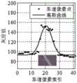
图2a是本发明实施例一中阴雨天对应的车道线横截面的灰度轮廓特征示意图。Fig. 2a is a schematic diagram showing the grayscale profile characteristics of the cross-section of the lane line corresponding to a cloudy and rainy day in Embodiment 1 of the present invention.
图2b是本发明实施例一中晴天对应的车道线横截面的灰度轮廓特征示意图。FIG. 2b is a schematic diagram of the grayscale profile characteristics of the cross-section of the lane line corresponding to the sunny day in Embodiment 1 of the present invention.
图2c是本发明实施例一中夜晚对应的车道线横截面的灰度轮廓特征示意图。FIG. 2c is a schematic diagram of the gray-scale profile feature of the cross-section of the lane line corresponding to the night in Embodiment 1 of the present invention.
图3是本发明实施例一中匹配滤波器的数学模型示意图。FIG. 3 is a schematic diagram of a mathematical model of a matched filter in Embodiment 1 of the present invention.
图4是本发明实施例一中不同场景下的经过匹配滤波和顶帽变换的处理结果示意图。FIG. 4 is a schematic diagram of processing results of matched filtering and top hat transformation in different scenarios in Embodiment 1 of the present invention.
图5a是本发明实施例一中获取的原始图像示意图。FIG. 5a is a schematic diagram of an original image obtained in Embodiment 1 of the present invention.
图5b是本发明实施例一中获取的初始化感兴趣区域的示意图。FIG. 5b is a schematic diagram of an initialized region of interest obtained in Embodiment 1 of the present invention.
图5c是本发明实施例一中获取的下一帧图像的感兴趣区域的示意图。FIG. 5c is a schematic diagram of a region of interest of the next frame of image acquired in Embodiment 1 of the present invention.
图6是本发明实施例一一种车道线识别方法的另一流程示意图。FIG. 6 is another schematic flowchart of a method for identifying lane lines according to an embodiment of the present invention.
图7是本发明实施例二一种车道线识别系统的原理框图。FIG. 7 is a principle block diagram of a lane line recognition system according to the second embodiment of the present invention.
图8是本发明实施例二中感兴趣区域划定模块的原理框图。FIG. 8 is a principle block diagram of a region of interest delineation module in Embodiment 2 of the present invention.
图9是本发明实施例二中恒虚警率筛选车道线特征点的方法原理图。FIG. 9 is a schematic diagram of a method for screening lane line feature points with a constant false alarm rate in Embodiment 2 of the present invention.
具体实施方式Detailed ways
以下各实施例的说明是参考附图,用以示例本发明可以用以实施的特定实施例。The following descriptions of the various embodiments refer to the accompanying drawings to illustrate specific embodiments in which the invention may be practiced.
请参照图1所示,本发明实施例一提供一种车道线识别方法,包括下述步骤:Referring to FIG. 1 , Embodiment 1 of the present invention provides a method for identifying lane lines, including the following steps:
S100、对获取的包含车道线的灰度图像划定感兴趣区域;S100. Delineate a region of interest for the acquired grayscale image including lane lines;
S200、采用匹配滤波器对图像感兴趣区域进行多尺度匹配滤波,完成图像感兴趣区域的特定增强;S200, using a matched filter to perform multi-scale matched filtering on the region of interest in the image to complete specific enhancement of the region of interest in the image;
S300、对经多尺度匹配滤波后的图像感兴趣区域进行顶帽变换;S300, performing top hat transformation on the region of interest of the image after multi-scale matched filtering;
S400、通过在图像感兴趣区域设定灰度自适应门限与待检测像素点进行比较,筛选车道线特征点;S400, by setting a grayscale adaptive threshold in the region of interest of the image and comparing the pixel points to be detected, filter the lane line feature points;
S500、对筛选出的车道线特征点进行逆投影变换,获取车道线特征点对应的二维栅格地图;S500. Perform inverse projection transformation on the selected lane line feature points to obtain a two-dimensional grid map corresponding to the lane line feature points;
S600、对二维栅格地图进行车道线特征点的邻域聚类处理,再对完成邻域聚类处理的车道线像素点进行曲线拟合,根据曲线拟合结果及车辆的当前位置确定车辆所在车道的车道线。S600. Perform neighborhood clustering processing of lane line feature points on the two-dimensional grid map, and then perform curve fitting on the lane line pixel points that have completed neighborhood clustering processing, and determine the vehicle according to the curve fitting result and the current position of the vehicle The lane line of the lane you are on.
进一步地,步骤S100之前还包括下述步骤:通过设置在车上的相机在线获取包含车道线的图像,或者通过加载摄像机录制的道路视频离线获取包含车道线的图像,如果获取的图像为彩色,则将该图像转换为对应的灰度图像。Further, before step S100, the following steps are also included: obtain an image including lane lines online by a camera set on the vehicle, or obtain an image including lane lines offline by loading a road video recorded by the camera, if the obtained image is in color, Then convert the image to the corresponding grayscale image.
对灰度图像分别以水平和竖直方向建立图像坐标系。The image coordinate system is established in horizontal and vertical directions for grayscale images, respectively.
进一步地,步骤S200中的匹配滤波器对图像感兴趣区域进行多尺度匹配滤波具体包括:通过改变匹配滤波器的尺度参数来改变增强区域和减弱区域的大小,实现在图像感兴趣区域内进行不同尺度的匹配滤波,其中,匹配滤波器的尺度参数由图像坐标系中不同横行内车道线的宽度决定,不同横行内车道线的宽度由投影变换得到。Further, the matched filter in step S200 performs multi-scale matched filtering on the region of interest of the image specifically includes: changing the size of the enhanced region and the weakened region by changing the scale parameter of the matched filter, so as to realize different filtering in the region of interest of the image. Scale-matched filtering, in which the scale parameter of the matched filter is determined by the width of the lane lines in different horizontal lines in the image coordinate system, and the width of the lane lines in different horizontal lines is obtained by projection transformation.
匹配滤波器的尺度参数σ、图像坐标系中不同横行内车道线宽度w之间满足:
步骤S300具体包括:利用半径为r的圆形结构元素S对图像感兴趣区域进行顶帽变换,设顶帽变换前的图像为F,顶帽变换后的图像为H,则H满足F与F的开运算之差:
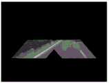
顶帽变换(Top-hat)的结果是非负的,当选用合适形状尺寸的结构元素时,可以检测出图像中较尖锐的波峰。对匹配滤波后的图像利用一定半径的圆形结构元素进行顶帽变换(Top-hat)处理,降低非均匀背景的干扰,如图4所示为不同场景下经过匹配滤波和顶帽变换的处理结果。The result of the top-hat transformation is non-negative, and when the structuring elements of suitable shape and size are selected, sharper peaks in the image can be detected. The image after matched filtering is processed by top-hat transformation (Top-hat) with circular structural elements of a certain radius to reduce the interference of non-uniform background. Figure 4 shows the processing of matched filtering and top-hat transformation in different scenarios. result.
步骤S400具体包括:检测图像感兴趣区域,将超过灰度自适应门限U的区域作为车道线特征点,其中,灰度自适应门限U=kσ+u,u为在一定参考单元内估算出的灰度均值,σ为在一定参考单元内估算出的灰度方差,k为参考单元个数。Step S400 specifically includes: detecting the area of interest in the image, and taking the area exceeding the grayscale adaptive threshold U as the lane line feature point, where the grayscale adaptive threshold U=kσ+u, and u is estimated in a certain reference unit. Gray mean, σ is the gray variance estimated in a certain reference unit, k is the number of reference units.
进一步地,步骤S100包括下述步骤:Further, step S100 includes the following steps:
获取车前横向和纵向的预设距离范围内的灰度图像。Acquires grayscale images within preset distances in front of the vehicle, both horizontally and vertically.
结合拍摄图像的相机或摄像机的内部参数和外部参数,得到一梯形区域,作为初始化感兴趣区域。Combining the internal parameters and external parameters of the camera or video camera that captures the image, a trapezoidal region is obtained as the initialized region of interest.
在图像坐标系下,根据上一帧感兴趣区域的检测结果,利用投影变换得到图像坐标系下的前帧车道线位置。In the image coordinate system, according to the detection result of the region of interest in the previous frame, the position of the lane line in the previous frame in the image coordinate system is obtained by projection transformation.
以前帧车道线位置为中心,左右拓展预设的像素范围后,得到下一帧图像的感兴趣区域。Taking the position of the lane line in the previous frame as the center, after expanding the preset pixel range left and right, the area of interest of the next frame image is obtained.
例如:初始化的感兴趣区域(ROI区域)的设定依照横向和纵向的一定距离范围,横向距离上取车辆左右对称5米,纵向上根据相机的有效视距,取45米。感兴趣区域的动态调整中以前帧车道线的图像坐标位置为中心,左右对称扩展一定的像素范围,扩展的像素范围取30个像素。For example, the initialized area of interest (ROI area) is set according to a certain distance range in the horizontal and vertical directions. The horizontal distance is 5 meters symmetrical to the left and right of the vehicle, and the vertical distance is 45 meters according to the effective line of sight of the camera. In the dynamic adjustment of the region of interest, the image coordinate position of the lane line in the previous frame is taken as the center, and a certain pixel range is symmetrically expanded on the left and right, and the expanded pixel range is 30 pixels.
在另一实施例中,获取的原始图像如图5a所示,经过感兴趣区域划定模块1010处理得到的初始化感兴趣区域如图5b所示,动态调整得到下一帧的感兴趣区域如图5c所示。In another embodiment, the acquired original image is shown in Fig. 5a, the initialized region of interest obtained after processing by the region of interest delineation module 1010 is shown in Fig. 5b, and the region of interest of the next frame obtained by dynamic adjustment is shown in Fig. 5c.
进一步地,步骤S400中,在待检测像素点与参考单元之间,依据车道线最大宽度预留若干护卫单元。护卫单元取图像近视野区域中车道线的最大宽度25个像素,以防止车道线被当作待检测像素点两侧的参考单元,错误地被纳入到自适应门限的计算。根据前述灰度自适应门限的计算方式,如果车道线被当作参考单元,会使参考单元内估算出的灰度均值以及灰度方差均出现较大偏差,导致灰度自适应门限计算结果不准确。Further, in step S400, between the pixel to be detected and the reference unit, a number of guard units are reserved according to the maximum width of the lane line. The guard unit takes the maximum width of the lane line in the near field of view of the image to be 25 pixels to prevent the lane line from being mistakenly included in the calculation of the adaptive threshold as a reference unit on both sides of the pixel to be detected. According to the above calculation method of the grayscale adaptive threshold, if the lane line is used as the reference unit, the grayscale mean and grayscale variance estimated in the reference unit will be greatly deviated, resulting in inconsistent results of the grayscale adaptive threshold calculation. precise.
进一步地,步骤S500中对筛选出的车道线特征点进行逆投影变换,具体是通过标定的3×4投影矩阵M进行,以获得车道线特征点在车辆坐标系下的坐标,标定的3×4投影矩阵M由相机或摄像机的内部参数和外部参数共同确定。更具体地,依据下述模型对所筛选的车道线特征点进行逆投影变换:Further, in step S500, inverse projection transformation is performed on the screened lane line feature points, specifically through the calibrated 3×4 projection matrix M, to obtain the coordinates of the lane line feature points in the vehicle coordinate system, the calibrated 3×4 4. The projection matrix M is jointly determined by the internal parameters and external parameters of the camera or camera. More specifically, inverse projection transformation is performed on the selected lane line feature points according to the following model:

进一步地,该车道线识别方法还包括:Further, the lane line recognition method also includes:
S700、对车道线进行每一横行的横向位置分析,并通过距离或/和平行度约束,确定车道线的有效性。S700. Perform a lateral position analysis of each lateral line on the lane line, and determine the validity of the lane line through distance or/and parallelism constraints.
进一步地,步骤S700之后包括下述步骤:Further, the following steps are included after step S700:
S810、提取当前帧图像对应的本帧车道线。S810: Extract the lane line of the current frame corresponding to the current frame image.
S820、判断数据库中是否已装载有车道线,若是,则将本帧车道线与数据库中的车道线进行匹配,若否,则将本帧车道线装载进数据库。S820: Determine whether there are lane lines already loaded in the database, if so, match the lane lines in the current frame with the lane lines in the database; if not, load the lane lines in the current frame into the database.
进一步地,步骤S820之后还包括:Further, after step S820, it also includes:
S830、当数据库中存在与本帧车道线匹配的车道线时,用本帧车道线替换数据库中匹配的车道线,且对应匹配的车道线的匹配数量自增预设值a,数据库中其他未发生匹配的车道线对应的匹配数量自减预设值a。S830. When there is a lane line matching the lane line of this frame in the database, replace the matched lane line in the database with the lane line of this frame, and the matching number of the corresponding matching lane line is automatically incremented by a preset value a, and other unidentified lane lines in the database The matching number corresponding to the matching lane line is decremented by the preset value a.
S840、将匹配数量超过预设值N的车道线设定为有效车道线。S840. Set the lane lines whose matching number exceeds the preset value N as valid lane lines.
S850、检测数据库中的车道线对应的匹配数量,若有车道线的匹配数量小于最小预设值,则将其置为最小预设值,若有车道线的匹配数量大于最大预设值,则将其置为最大预设值。S850. Detect the number of matches corresponding to lane lines in the database. If the number of matches of any lane line is less than the minimum preset value, set it as the minimum preset value, and if the number of matches of any lane line is greater than the maximum preset value, then Set it to the maximum preset value.
步骤S820之后还包括下述步骤:After step S820, the following steps are also included:
S860、当数据库中不存在与本帧车道线匹配的车道线时,遍历数据库中车道线的匹配数量,当数据库中存在匹配数量为最小预设值的车道线时,用本帧车道线将第一个匹配数量为最小预设值的车道线替换,当数据库中不存在匹配数量为最小预设值的车道线时,将本帧车道线装载进数据库,且本帧车道线的匹配数量设为预设值a,数据库中在当前帧未发生匹配的车道线对应的匹配数量自减预设值a,执行完成后回到步骤S850。S860. When there is no lane line matching the lane line of this frame in the database, traverse the matching number of lane lines in the database, and when there is a lane line whose matching number is the minimum preset value in the database, use the lane line of this frame to A lane line whose matching number is the minimum preset value is replaced. When there is no lane line whose matching number is the minimum preset value in the database, the current frame lane line is loaded into the database, and the matching number of this frame lane line is set to The preset value a, the number of matches corresponding to the lane lines that have not matched in the current frame in the database is decremented by the preset value a, and returns to step S850 after the execution is completed.
进一步地,步骤S820中当数据库中已装载有车道线,获取本帧车道线对应参数的二次项系数A02、一次项系数A01,以及数据库中车道线对应参数的二次项系数Ai2、一次项系数Ai1,并将本帧车道线对应参数的二次项系数A02与数据库中车道线对应参数的二次项系数Ai2之差的绝对值,与本帧车道线对应参数的一次项系数A01与数据库中车道线对应参数的一次项系数Ai1求和,得到跟踪匹配距离阈值;判断跟踪匹配距离阈值是否在预设的范围内,若是,则将本帧车道线与数据库中的车道线进行匹配。根据下述公式计算跟踪匹配距离阈值T:Further, in step S820, when the lane lines are loaded in the database, the quadratic term coefficient A02 , the first-order term coefficient A01 of the parameters corresponding to the lane lines in this frame, and the quadratic term coefficient Ai2 of the parameters corresponding to the lane lines in the database are obtained. , the first-order coefficient Ai1 , and the absolute value of the difference between the quadratic coefficient A02 of the parameter corresponding to the lane line in this frame and the quadratic coefficient Ai2 of the parameter corresponding to the lane line in the database, and the corresponding parameter of the lane line in this frame The absolute value of the difference The first-order coefficient A01 is summed with the first-order coefficient Ai1 of the corresponding parameters of the lane lines in the database to obtain the tracking matching distance threshold; it is judged whether the tracking matching distance threshold is within the preset range, and if so, then the lane line of this frame is compared with the database. match the lane lines in . The tracking matching distance threshold T is calculated according to the following formula:
T=|A02-Ai2|+|A01-Ai1|;T=|A02 -Ai2 |+|A01 -Ai1 |;
判断跟踪匹配距离阈值T是否在预设的范围内,若是,则将本帧车道线与数据库中的车道线进行匹配。例如,在另一实施例中,跟踪匹配距离阈值取0.1,车道线匹配数量阈值预设值N取5,当对应匹配数量超过5的车道线即认定为有效的车道线。Determine whether the tracking matching distance threshold T is within the preset range, and if so, match the lane line of the current frame with the lane line in the database. For example, in another embodiment, the tracking matching distance threshold is 0.1, and the preset value N of the lane line matching number threshold is 5. When the corresponding matching number exceeds 5 lane lines, it is considered as a valid lane line.
进一步地,该车道线识别方法还包括下述步骤:当跟踪匹配距离阈值T不在预设的范围内,则将本帧车道线装载进数据库。进一步地,在初始使用本发明的车道线识别系统时,将数据库初始化,车道线的匹配数量全部清零。Further, the lane line identification method further includes the following steps: when the tracking matching distance threshold T is not within the preset range, loading the lane line of the frame into the database. Further, when the lane line recognition system of the present invention is initially used, the database is initialized, and the matching numbers of lane lines are all cleared.
本发明还提供了车道线识别方法的另一实施例,如图6所示,步骤如下:The present invention also provides another embodiment of the lane line identification method, as shown in FIG. 6 , the steps are as follows:
在初始使用时,将数据库初始化,数据库中的车道线匹配数量清零。During initial use, the database is initialized, and the number of lane line matching in the database is cleared to zero.
提取出当前帧图像对应的本帧车道线。The lane line of the current frame corresponding to the current frame image is extracted.
判断数据库中是否装载有车道线,若是,则将本帧车道线逐个与数据库中的车道线进行匹配,若否,则将本帧车道线装载进数据库,该本帧车道线对应的匹配数量自增1。Determine whether there are lane lines loaded in the database, if so, match the lane lines in this frame with the lane lines in the database one by one; Increment 1.
当数据库中存在与本帧车道线匹配的车道线时,用本帧车道线替换数据库中对应匹配的车道线,且对应匹配的车道线相应的匹配数量自增1,其他未发生匹配的车道线的匹配数量自减1。接着,对数据库中的进行车道线进行匹配数量的检测,若匹配数量小于0,则将其置为0,若匹配数量大于25,则将其置为25。当车道线的匹配数量超过一定值时,则确定其为有效车道线。执行完成之后,再继续提取出当前帧图像对应的本帧车道线,继续后面的流程。When there is a lane line matching the lane line of this frame in the database, the lane line of this frame is used to replace the corresponding matching lane line in the database, and the corresponding matching number of the corresponding matching lane line is automatically increased by 1, and other lane lines that do not match The number of matches is decremented by 1. Next, the number of matches is detected for the lane lines in the database. If the number of matches is less than 0, it is set to 0, and if the number of matches is greater than 25, it is set to 25. When the matching number of lane lines exceeds a certain value, it is determined as a valid lane line. After the execution is completed, continue to extract the lane line of the current frame corresponding to the current frame image, and continue the subsequent process.
当数据库中不存在与本帧车道线匹配的车道线时,则遍历数据库中车道线的匹配数量,将第一个匹配数量为0的车道线替换,若没有匹配数量为0的车道线,则将本帧车道线额外增加进数据库,并且对应的匹配数量变为1,数据库中其他的车道线的匹配数量自减1。之后,再对数据库中的车道线进行车道线匹配数量的检测,若匹配数量小于0,则将其置为0,若匹配数量大于25,则将其置为25。当车道线的匹配数量超过一定值时,则确定其为有效车道线。执行完成之后,再继续提取出当前帧图像对应的本帧车道线,继续后面的流程。When there is no lane line matching the lane line of this frame in the database, traverse the matching number of lane lines in the database, and replace the first lane line with a matching number of 0. If there is no lane line with a matching number of 0, then The lane lines of this frame are additionally added to the database, and the corresponding matching number becomes 1, and the matching number of other lane lines in the database is decremented by 1. After that, the lane lines in the database are checked for the number of lane line matches. If the number of matches is less than 0, it is set to 0, and if the number of matches is greater than 25, it is set to 25. When the matching number of lane lines exceeds a certain value, it is determined as a valid lane line. After the execution is completed, continue to extract the lane line of the current frame corresponding to the current frame image, and continue the subsequent process.
通过上述说明可知,本实施例带来的有益效果在于:对获取的车道线灰度图像划定感兴趣区域,并对其进行多尺度的匹配滤波,实现多种场景下对车道线图像感兴趣区域的显著增强,在顶帽变换的基础上进一步消除背景干扰,采用灰度自适应门限对车道线特征点进行有效筛选,从而极大减弱外界条件的变化对基于机器视觉的车道线识别的影响,进一步提高了车道线识别的准确率。此外,本发明还将本帧提取出的车道线参数与数据库中的车道线进行匹配分析,确定其有效性,并动态更新数据库,保证车道线识别的稳定性。It can be seen from the above description that the beneficial effect brought by this embodiment is: to delineate the region of interest for the acquired grayscale image of the lane line, and perform multi-scale matched filtering on it, so as to realize the interest in the lane line image in various scenarios. The area is significantly enhanced, the background interference is further eliminated on the basis of the top hat transformation, and the grayscale adaptive threshold is used to effectively screen the lane line feature points, thereby greatly reducing the impact of changes in external conditions on the machine vision-based lane line recognition. , which further improves the accuracy of lane line recognition. In addition, the present invention also performs matching analysis between the lane line parameters extracted in this frame and the lane lines in the database to determine its validity, and dynamically update the database to ensure the stability of lane line recognition.
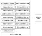
相应于本发明实施例一,本发明实施例二提供一种车道线识别系统,如图7所示,该系统包括:车道线识别模块1000,该车道线识别模块1000进一步包括:Corresponding to the first embodiment of the present invention, the second embodiment of the present invention provides a lane line recognition system. As shown in FIG. 7 , the system includes: a lane line recognition module 1000, and the lane line recognition module 1000 further includes:
感兴趣区域划定模块1010,用于对获取的包含车道线的灰度图像划定感兴趣区域;A region of interest delineation module 1010, configured to delineate a region of interest for the acquired grayscale image including lane lines;
匹配滤波模块1020,用于采用匹配滤波器对图像感兴趣区域进行多尺度匹配滤波,完成所述图像感兴趣区域的特定增强;a matched filtering module 1020, configured to perform multi-scale matched filtering on a region of interest in an image by using a matched filter to complete specific enhancement of the region of interest in the image;
顶帽变换模块1030,用于对经多尺度匹配滤波后的所述图像感兴趣区域进行顶帽变换;a top-hat transformation module 1030, configured to perform top-hat transformation on the region of interest of the image after multi-scale matched filtering;
恒虚警率检测模块1040,用于通过在所述图像感兴趣区域设定灰度自适应门限与待检测像素点进行比较,筛选车道线特征点;The constant false alarm rate detection module 1040 is configured to filter the lane line feature points by setting a grayscale adaptive threshold in the region of interest of the image and comparing the pixel points to be detected;
地图制作模块1050,用于对筛选出的所述车道线特征点进行逆投影变换,获取所述车道线特征点对应的二维栅格地图;A map making module 1050, configured to perform inverse projection transformation on the selected lane line feature points to obtain a two-dimensional grid map corresponding to the lane line feature points;
车道线确定模块1060,用于对所述二维栅格地图进行车道线特征点的邻域聚类处理,再对完成邻域聚类处理的车道线像素点进行曲线拟合,根据曲线拟合结果及车辆的当前位置确定车辆所在车道的车道线。The lane line determination module 1060 is configured to perform neighborhood clustering processing of lane line feature points on the two-dimensional grid map, and then perform curve fitting on the lane line pixel points that have completed the neighborhood clustering processing, and perform curve fitting according to the curve fitting. The result and the current position of the vehicle determine the lane line of the lane where the vehicle is located.
具体地,匹配滤波器的尺度参数σ由图像坐标系中不同横行内车道线宽度w决定,
顶帽变换模块1030用于对图像感兴趣区域利用半径为预设值r的圆形结构元素S进行顶帽变换,以降低非均匀背景的干扰。设顶帽变换前的图像为F,顶帽变换后的图像为H,则H满足F与F的开运算之差:
恒虚警率检测模块1040用于通过在图像感兴趣区域设定自适应的门限与待检测像素点进行比较,筛选车道线特征点。这里恒虚警率检测模块1040可以是恒虚警率检测器,其将图像分为车道线区域和非车道线区域,在对图像某一像素点进行判断时,通过在局部区域设定自适应的门限来与待检测像素点进行比较,即可判断像素点是否为车道线特征点。The constant false alarm rate detection module 1040 is configured to set an adaptive threshold in the region of interest of the image and compare it with the pixel points to be detected, so as to filter the lane line feature points. Here, the constant false alarm rate detection module 1040 may be a constant false alarm rate detector, which divides the image into a lane line area and a non-lane line area. The threshold is compared with the pixel points to be detected, and it can be judged whether the pixel points are the feature points of the lane line.
恒虚警率检测模块1040筛选车道线特征具体包括:检测图像感兴趣区域,将超过灰度自适应门限U的区域作为车道线特征点,其中,灰度自适应门限U=kσ+u,u为在一定参考单元内估算出的灰度均值,σ为在一定参考单元内估算出的灰度方差,k为参考单元个数。The constant false alarm rate detection module 1040 filters the lane line features specifically including: detecting the area of interest in the image, and taking the area exceeding the grayscale adaptive threshold U as the lane line feature point, where the grayscale adaptive threshold U=kσ+u, u is the grayscale mean value estimated in a certain reference unit, σ is the grayscale variance estimated in a certain reference unit, and k is the number of reference units.
地图制作模块1050用于通过标定的3×4投影矩阵M,对筛选出的车道线特征点进行逆投影变换,获取车道线特征点在车辆坐标系下的坐标及车道线特征点对应的二维栅格地图。其中,标定的3×4投影矩阵M利用由拍摄图像的摄像机或相机的内部参数和外部参数共同确定,地图制作模块1050依据下述模型对所筛选的车道线特征点进行逆投影变换:The map making module 1050 is used to perform inverse projection transformation on the selected lane line feature points through the calibrated 3×4 projection matrix M, and obtain the coordinates of the lane line feature points in the vehicle coordinate system and the two-dimensional corresponding to the lane line feature points. Raster map. Wherein, the calibrated 3×4 projection matrix M is jointly determined by the internal parameters and external parameters of the camera or camera that captures the image, and the map making module 1050 performs inverse projection transformation on the selected lane line feature points according to the following model:

车道线确定模块1060用于对二维栅格地图进行车道线特征点的邻域聚类处理,再对完成邻域聚类处理的车道线像素点进行曲线拟合,根据曲线拟合结果及当前车辆的位置确定该车辆所在车道的车道线。在另一实施例中,在邻域聚类过程中选择搜索框大小为5个像素。The lane line determination module 1060 is used to perform the neighborhood clustering processing of the lane line feature points on the two-dimensional grid map, and then perform curve fitting on the lane line pixel points that have completed the neighborhood clustering processing. The position of a vehicle determines the lane line of the lane in which the vehicle is located. In another embodiment, a search box size of 5 pixels is chosen during the neighborhood clustering process.
通常情况下,车辆在车道内行驶,因此采集得到的标示线方向整体上与车辆行驶方向相一致,并且多条车道标示线近似形状相同,其长度比地面其它标示线等干扰线要长,利用这些特点对车道标示线进行邻域聚类,得到归属于同一条标示线的像素点。根据上述聚类结果,对每组数据进行参数曲线拟合,采用二次曲线模型来拟合车道标示线,再根据拟合结果及当前车辆的位置确定车辆所在车道的左右两侧车道线。Usually, the vehicle is driving in the lane, so the direction of the collected marking line is consistent with the driving direction of the vehicle as a whole, and the approximate shape of the multiple lane marking lines is the same, and its length is longer than the interference lines such as other marking lines on the ground. These features perform neighborhood clustering on lane marking lines to obtain pixels belonging to the same marking line. According to the above clustering results, parametric curve fitting is performed for each group of data, and a quadratic curve model is used to fit the lane markings, and then the left and right lane lines of the lane where the vehicle is located are determined according to the fitting results and the current vehicle position.
进一步地,该车道线识别系统还包括:摄像模块2000,摄像模块2000设置在车上,包括:相机和/或摄像机,与车道线识别模块1000通讯连接,用于拍摄照片并回传至车道线识别模块1000,和/或获取录制道路视频。车道线识别模块1000还包括:图像获取模块1070、建立坐标模块1080。图像获取模块1070用于通过设置在车辆上的相机在线获取包含车道线的图像,或者通过加载摄像机录制的道路视频离线获取包含车道线的图像,如果获取的图像为彩色,则将该图像转换为对应的灰度图像。建立坐标模块1080用于对灰度图像分别以水平和竖直方向建立图像坐标系。Further, the lane line recognition system further includes: a camera module 2000, the camera module 2000 is arranged on the vehicle, and includes a camera and/or a video camera, which is connected in communication with the lane line recognition module 1000, and is used for taking pictures and sending them back to the lane line Identify module 1000, and/or acquire recorded road video. The lane line recognition module 1000 further includes: an image acquisition module 1070 and a coordinate establishment module 1080 . The image acquisition module 1070 is used to acquire an image containing lane lines online through a camera set on the vehicle, or acquire an image containing lane lines offline by loading the road video recorded by the camera, and if the acquired image is in color, convert the image to The corresponding grayscale image. The establishing coordinate module 1080 is used to establish an image coordinate system in the horizontal and vertical directions respectively for the grayscale image.
进一步地,如图8所示,感兴趣区域划定模块1010包括:图像截取单元1011、感兴趣区域制定单元1012。其中,图像截取单元1011用于获取车前横向和纵向的预设距离范围内的灰度图像。感兴趣区域制定单元1012用于结合拍摄图像的相机或摄像机的内部参数和外部参数,得到一梯形区域,作为初始化感兴趣区域。Further, as shown in FIG. 8 , the ROI defining module 1010 includes: an image capturing unit 1011 and a ROI specifying unit 1012 . Wherein, the image capturing unit 1011 is configured to acquire grayscale images within a preset distance range in the horizontal and vertical directions in front of the vehicle. The region of interest formulating unit 1012 is configured to combine the internal parameters and external parameters of the camera or video camera that captures the image to obtain a trapezoidal region as the initialized region of interest.
进一步地,感兴趣区域划定模块1010还包括:前帧车道线获取单元1013、下一帧感兴趣区域获取单元1014。前帧车道线获取单元1013用于在图像坐标系下,根据上一帧感兴趣区域的检测结果,利用投影变换得到图像坐标系下的前帧车道线位置。下一帧感兴趣区域获取单元1014用于以前帧车道线位置为中心,左右拓展预设的像素范围后,得到下一帧图像的感兴趣区域。Further, the area of interest delineation module 1010 further includes: a lane line acquisition unit 1013 in the previous frame, and an area of interest acquisition unit 1014 in the next frame. The previous frame lane line obtaining unit 1013 is configured to obtain the previous frame lane line position in the image coordinate system by using projection transformation according to the detection result of the region of interest in the previous frame in the image coordinate system. The next frame ROI obtaining unit 1014 is configured to obtain the ROI of the next frame image after extending the preset pixel range left and right with the lane line position of the previous frame as the center.
进一步地,恒虚警率检测模块1040中还包括:预留距离单元。预留距离单元用于在待检测像素点与参考单元之间,依据车道线最大宽度预留若干护卫单元。护卫单元取图像感兴趣区域对应的图像近视野区域中车道线的最大宽度25个像素,以防止车道线被当作待检测像素点两侧的参考单元参与参考单元区域的灰度强度的估计。Further, the constant false alarm rate detection module 1040 further includes: a reserved distance unit. The reserved distance unit is used to reserve a number of guard units between the pixel point to be detected and the reference unit according to the maximum width of the lane line. The guard unit takes the maximum width of the lane line in the near-field area of the image corresponding to the area of interest of the image to be 25 pixels to prevent the lane line from being used as the reference unit on both sides of the pixel to be detected to participate in the estimation of the gray intensity of the reference unit area.
恒虚警率检测模块1040可选择为恒虚警率检测器,由于设计的恒虚警率检测器是针对点目标的,而车道线往往具有一定宽度,因此,需依据车道线最大宽度预留若干距离单元(称为护卫单元),防止车道线作为参考单元对自适应门限造成影响。车道线候选特征点的恒虚警率筛选方法原理如图9所示。各检测单元中超灰度过自适应门限U的区域被认定为H0区域(车道线区域),即为候选车道线的特征点。其中,灰度自适应门限U=kσ+u,其中u、σ为在一定参考单元内估算出的灰度均值和方差,在另一实施例中,参考单元的个数取30,护卫单元取图像近视野区域中车道线的最大宽度25个像素。进一步地,该车道线识别模块1000还包括:有效性确定模块1090。有效性确定模块1090用于对左右两侧车道线进行每一横行的横向位置分析,并通过距离或/和平行度约束,确定车道线的有效性。The constant false alarm rate detection module 1040 can be selected as a constant false alarm rate detector. Since the designed constant false alarm rate detector is aimed at point targets, and the lane line often has a certain width, it needs to be reserved according to the maximum width of the lane line. Several distance units (called guard units) prevent the lane line from affecting the adaptive threshold as a reference unit. The principle of the constant false alarm rate screening method for the candidate feature points of the lane line is shown in Figure 9. The area that exceeds the gray level and exceeds the adaptive threshold U in each detection unit is identified as the H0 area (lane line area), which is the feature point of the candidate lane line. Among them, the grayscale adaptive threshold U=kσ+u, where u and σ are the grayscale mean and variance estimated in a certain reference unit. In another embodiment, the number of reference units is 30, and the guard unit is The maximum width of lane lines in the near field of view of the image is 25 pixels. Further, the lane line recognition module 1000 further includes: a validity determination module 1090 . The validity determination module 1090 is used to analyze the lateral position of each lateral line on the left and right lane lines, and determine the validity of the lane lines through distance or/and parallelism constraints.
进一步地,该车道线识别模块1000还包括:本帧车道线提取模块1100、车道线判断模块1110、匹配数量运算模块1120、有效车道线设定模块1130。Further, the lane line identification module 1000 further includes: a lane line extraction module 1100 of the current frame, a lane line judgment module 1110 , a matching quantity calculation module 1120 , and a valid lane line setting module 1130 .
本帧车道线提取模块1100用于提取当前帧图像对应的本帧车道线。车道线判断模块1110用于判断数据库中是否已装载有车道线,若是,则将本帧车道线与数据库中的车道线进行匹配,若否,则将本帧车道线装载进数据库。匹配数量运算模块1120用于当数据库中存在与本帧车道线匹配的车道线时,用本帧车道线替换数据库中匹配的车道线,且对应匹配的车道线的匹配数量自增预设值a,数据库中其他未发生匹配的车道线对应的匹配数量自减预设值a。有效车道线设定模块1130用于将匹配数量超过预设值N的车道线设定为有效车道线。例如,预设值a可为1。The current frame lane line extraction module 1100 is used to extract the current frame lane line corresponding to the current frame image. The lane line judging module 1110 is used for judging whether a lane line has been loaded in the database, if so, matching the lane line of the current frame with the lane line in the database, if not, loading the lane line of the current frame into the database. The matching number calculation module 1120 is used to replace the matching lane line in the database with the current frame lane line when there is a lane line matching the current frame lane line in the database, and the matching number of the corresponding matching lane line is automatically incremented by a preset value a. , the number of matches corresponding to other lane lines that have not been matched in the database will be decremented by the preset value a. The valid lane line setting module 1130 is configured to set the lane lines whose matching number exceeds the preset value N as valid lane lines. For example, the preset value a may be 1.
进一步地,该车道线识别模块1000还包括:匹配数量校验模块1140、遍历匹配模块1150。Further, the lane line identification module 1000 further includes: a matching quantity verification module 1140 and a traversal matching module 1150 .
匹配数量校验模块1140用于检测数据库中的车道线对应的匹配数量,若有车道线的匹配数量小于最小预设值,则将其置为最小预设值,若有车道线的匹配数量大于最大预设值,则将其置为最大预设值。例如,最小预设值可为0,最大预设值可为25。The matching number checking module 1140 is used to detect the matching number corresponding to the lane lines in the database. If the matching number of the lane lines is less than the minimum preset value, it will be set to the minimum preset value. If the matching number of the lane lines is greater than the minimum preset value the maximum preset value, set it to the maximum preset value. For example, the minimum preset value may be 0, and the maximum preset value may be 25.
遍历匹配模块1150用于当数据库中不存在与本帧车道线匹配的车道线时,则遍历数据库中车道线的匹配数量,当数据库中存在匹配数量为最小预设值的车道线时,用本帧车道线将第一个匹配数量为最小预设值的车道线替换,当数据库中不存在匹配数量为最小预设值的车道线时,将本帧车道线装载进数据库,且本帧车道线的匹配数量设为预设值a,数据库中在当前帧未发生匹配的车道线对应的匹配数量自减预设值a,执行完成后控制匹配数量校验模块1140工作。The traversal matching module 1150 is used to traverse the matching number of lane lines in the database when there is no lane line matching the lane line of the current frame in the database. The frame lane line will replace the first lane line whose matching number is the minimum preset value. When there is no lane line whose matching number is the minimum preset value in the database, the current frame lane line will be loaded into the database, and the current frame lane line will be loaded into the database. The number of matches is set to the default value a, the number of matches corresponding to the lane lines that do not match in the current frame in the database is decremented by the default value a, and the matching number verification module 1140 is controlled to work after the execution is completed.
进一步地,该车道线识别模块1000还包括:车道线阈值判断模块1160。车道线阈值判断模块1160用于当数据库中已装载有车道线,则获取本帧车道线对应参数的二次项系数A02、一次项系数A01,以及数据库中车道线对应参数的二次项系数Ai2、一次项系数Ai1,并将本帧车道线对应参数的二次项系数A02与数据库中车道线对应参数的二次项系数Ai2之差的绝对值,与本帧车道线对应参数的一次项系数A01与数据库中车道线对应参数的一次项系数Ai1求和,得到跟踪匹配距离阈值;判断跟踪匹配距离阈值是否在预设的范围内,若是,则控制车道线判断模块1110将本帧车道线与数据库中的车道线进行匹配。跟踪匹配距离阈值T计算公式如下:Further, the lane line recognition module 1000 further includes: a lane line threshold value judgment module 1160 . The lane line threshold judging module 1160 is used to obtain the quadratic term coefficient A02 , the primary term coefficient A01 of the parameters corresponding to the lane lines in this frame, and the quadratic term of the parameters corresponding to the lane lines in the database when the lane lines are loaded in the database The coefficient Ai2 , the first-order coefficient Ai1 , and the absolute value of the difference between the quadratic coefficient A02 of the parameter corresponding to the lane line in this frame and the quadratic coefficient Ai2 of the parameter corresponding to the lane line in the database, and the lane line in this frame. The first-order coefficient A01 of the corresponding parameter is summed with the first-order coefficient Ai1 of the corresponding parameter of the lane line in the database to obtain the tracking matching distance threshold; it is judged whether the tracking matching distance threshold is within the preset range, and if so, the lane line is controlled to judge The module 1110 matches the lane lines of the frame with the lane lines in the database. The calculation formula of the tracking matching distance threshold T is as follows:
T=|A02-Ai2|+|A01-Ai1|;T=|A02 -Ai2 |+|A01 -Ai1 |;
车道线阈值判断模块1160判断T值是否在预设的跟踪匹配距离阈值范围内,若是,则控制车道线判断模块1110将本帧车道线与数据库中的车道线进行匹配,若否,则不控制车道线判断模块1110将本帧车道线与数据库中的车道线进行匹配,而控制车道线判断模块1110将本帧车道线装载进数据库,更新数据库。The lane line threshold judgment module 1160 judges whether the T value is within the preset tracking matching distance threshold range, and if so, controls the lane line judgment module 1110 to match the lane line of the frame with the lane line in the database, if not, does not control The lane line judging module 1110 matches the lane lines of the current frame with the lane lines in the database, and controls the lane line judgment module 1110 to load the lane lines of the current frame into the database and update the database.
上述的数据库在内存中体现为一个多维数组,其中包含前几帧图像跟踪匹配得到的车道线参数、不匹配的车道线参数及其对应的匹配数量值,数据库中最大的车道线存贮数量为30。各车道线对应的最大匹配数量值为25,最小值为0。The above database is embodied in the memory as a multi-dimensional array, which contains the lane line parameters obtained by the tracking and matching of the previous frames, the unmatched lane line parameters and their corresponding matching quantity values. The maximum number of lane lines stored in the database is 30. The maximum matching number corresponding to each lane line is 25, and the minimum value is 0.
进一步地,该车道线识别模块1000还包括:车道线装载模块1170。车道线装载模块1170用于当跟踪匹配距离阈值不在预设的范围内,则将本帧车道线装载进数据库。Further, the lane line recognition module 1000 further includes: a lane line loading module 1170 . The lane line loading module 1170 is configured to load the lane line of the frame into the database when the tracking matching distance threshold is not within the preset range.
综上所述,本实施例对获取的车道线灰度图像划定感兴趣区域,并对其进行多尺度的匹配滤波,实现多种场景下对车道线图像感兴趣区域的显著增强,在顶帽变换的基础上进一步消除背景干扰,采用灰度自适应门限对车道线特征点进行有效筛选,从而极大减弱外界条件的变化对基于机器视觉的车道线识别的影响,进一步提高了车道线识别的准确率。此外,本实施例还将本帧提取出的车道线参数与数据库中的车道线进行匹配分析,确定其有效性,并动态更新数据库,保证车道线识别的稳定性。To sum up, in this embodiment, the acquired lane line grayscale image is demarcated the region of interest, and multi-scale matched filtering is performed on it, so as to achieve significant enhancement of the region of interest in the lane line image in various scenarios. On the basis of hat transformation, the background interference is further eliminated, and the grayscale adaptive threshold is used to effectively screen the feature points of the lane line, thereby greatly reducing the influence of changes in external conditions on the lane line recognition based on machine vision, and further improving the lane line recognition. 's accuracy. In addition, this embodiment also performs matching analysis between the lane line parameters extracted in this frame and the lane lines in the database to determine its validity, and dynamically update the database to ensure the stability of lane line recognition.
以上内容是结合具体的优选实施方式对本发明所作的进一步详细说明,不能认定本发明的具体实施只局限于这些说明。对于本发明所属技术领域的普通技术人员来说,在不脱离本发明构思的前提下,还可以做出若干简单推演或替换,都应当视为属于本发明的保护范围。The above content is a further detailed description of the present invention in combination with specific preferred embodiments, and it cannot be considered that the specific implementation of the present invention is limited to these descriptions. For those of ordinary skill in the technical field of the present invention, without departing from the concept of the present invention, some simple deductions or substitutions can be made, which should be regarded as belonging to the protection scope of the present invention.
Claims (24)

Priority Applications (1)
| Application Number | Priority Date | Filing Date | Title |
|---|---|---|---|
| CN201710419310.0ACN107330376B (en) | 2017-06-06 | 2017-06-06 | Lane line identification method and system |
Applications Claiming Priority (1)
| Application Number | Priority Date | Filing Date | Title |
|---|---|---|---|
| CN201710419310.0ACN107330376B (en) | 2017-06-06 | 2017-06-06 | Lane line identification method and system |
Publications (2)
| Publication Number | Publication Date |
|---|---|
| CN107330376A CN107330376A (en) | 2017-11-07 |
| CN107330376Btrue CN107330376B (en) | 2020-01-21 |
Family
ID=60193856
Family Applications (1)
| Application Number | Title | Priority Date | Filing Date |
|---|---|---|---|
| CN201710419310.0AActiveCN107330376B (en) | 2017-06-06 | 2017-06-06 | Lane line identification method and system |
Country Status (1)
| Country | Link |
|---|---|
| CN (1) | CN107330376B (en) |
Families Citing this family (25)
| Publication number | Priority date | Publication date | Assignee | Title |
|---|---|---|---|---|
| CN108038416B (en)* | 2017-11-10 | 2021-09-24 | 智车优行科技(北京)有限公司 | Lane line detection method and system |
| CN111989915B (en)* | 2018-04-02 | 2022-06-24 | 幻影人工智能公司 | Methods, media, and systems for automatic visual inference of environment in an image |
| WO2020004817A1 (en)* | 2018-06-26 | 2020-01-02 | 에스케이텔레콤 주식회사 | Apparatus and method for detecting lane information, and computer-readable recording medium storing computer program programmed to execute same method |
| CN110796606B (en)* | 2018-08-01 | 2023-07-07 | 新疆万兴信息科技有限公司 | Method, device, electronic equipment and medium for determining IPM matrix parameters |
| CN110795961B (en)* | 2018-08-01 | 2023-07-18 | 新疆万兴信息科技有限公司 | Lane line detection method and device, electronic equipment and medium |
| CN110909575B (en)* | 2018-09-17 | 2023-04-18 | 毫末智行科技有限公司 | Method and device for determining analysis area in lane line detection |
| CN110363054B (en)* | 2018-11-16 | 2021-10-01 | 北京京东叁佰陆拾度电子商务有限公司 | Road marking line identification method, device and system |
| CN109579847B (en)* | 2018-12-13 | 2022-08-16 | 歌尔股份有限公司 | Method and device for extracting key frame in synchronous positioning and map construction and intelligent equipment |
| CN109784234B (en)* | 2018-12-29 | 2022-01-07 | 阿波罗智能技术(北京)有限公司 | Right-angled bend identification method based on forward fisheye lens and vehicle-mounted equipment |
| CN109711385A (en)* | 2019-01-09 | 2019-05-03 | 宽凳(北京)科技有限公司 | A kind of Lane detection method, apparatus, equipment and storage medium |
| CN109948504B (en)* | 2019-03-13 | 2022-02-18 | 东软睿驰汽车技术(沈阳)有限公司 | Lane line identification method and device |
| WO2020220182A1 (en)* | 2019-04-29 | 2020-11-05 | 深圳市大疆创新科技有限公司 | Lane line detection method and apparatus, control device, and storage medium |
| CN110287960B (en)* | 2019-07-02 | 2021-12-10 | 中国科学院信息工程研究所 | Method for detecting and identifying curve characters in natural scene image |
| CN112215041B (en)* | 2019-07-11 | 2024-05-31 | 广州汽车集团股份有限公司 | End-to-end lane detection method and system |
| CN113255404A (en)* | 2020-02-11 | 2021-08-13 | 北京百度网讯科技有限公司 | Lane line recognition method and device, electronic device and computer-readable storage medium |
| CN111798698B (en)* | 2020-06-24 | 2022-04-08 | 中国第一汽车股份有限公司 | Method and device for determining front target vehicle and vehicle |
| CN111797766B (en)* | 2020-07-06 | 2022-01-11 | 三一专用汽车有限责任公司 | Identification method, identification device, computer-readable storage medium, and vehicle |
| CN112115784B (en)* | 2020-08-13 | 2021-09-28 | 北京嘀嘀无限科技发展有限公司 | Lane line identification method and device, readable storage medium and electronic equipment |
| CN112069924A (en)* | 2020-08-18 | 2020-12-11 | 东莞正扬电子机械有限公司 | Lane line detection method, lane line detection device and computer-readable storage medium |
| CN112319469A (en)* | 2020-11-16 | 2021-02-05 | 深圳市康士柏实业有限公司 | Lane keeping auxiliary system and method based on machine vision |
| CN112183512B (en)* | 2020-12-02 | 2021-11-19 | 深圳佑驾创新科技有限公司 | Camera calibration method, device, vehicle-mounted terminal and storage medium |
| CN112509452B (en)* | 2020-12-12 | 2022-05-17 | 武汉中海庭数据技术有限公司 | Method and system, server and medium for ground marking fusion based on road structure |
| CN112749680A (en)* | 2021-01-25 | 2021-05-04 | 蔚来汽车科技(安徽)有限公司 | Method and device for constructing a road model |
| CN114399904B (en)* | 2021-09-15 | 2023-07-28 | 芜湖易来达雷达科技有限公司 | Lane recognition method for automatically recognizing lanes by radar |
| CN119295974B (en)* | 2024-09-25 | 2025-08-05 | 中电科新型智慧城市研究院有限公司 | Traffic incident detection method, device and storage medium based on drone |
Citations (2)
| Publication number | Priority date | Publication date | Assignee | Title |
|---|---|---|---|---|
| CN103978978A (en)* | 2014-05-26 | 2014-08-13 | 武汉理工大学 | Inversion projection transformation based lane keeping method |
| CN106127787A (en)* | 2016-07-01 | 2016-11-16 | 北京美讯美通信息科技有限公司 | A kind of camera calibration method based on Inverse projection |
- 2017
- 2017-06-06CNCN201710419310.0Apatent/CN107330376B/enactiveActive
Patent Citations (2)
| Publication number | Priority date | Publication date | Assignee | Title |
|---|---|---|---|---|
| CN103978978A (en)* | 2014-05-26 | 2014-08-13 | 武汉理工大学 | Inversion projection transformation based lane keeping method |
| CN106127787A (en)* | 2016-07-01 | 2016-11-16 | 北京美讯美通信息科技有限公司 | A kind of camera calibration method based on Inverse projection |
Non-Patent Citations (3)
| Title |
|---|
| 基于机器视觉的嵌入式车道偏离预警系统的研究;张三林;《中国优秀硕士学位论文全文数据库信息科技辑》;20151229;正文第11页第2段-第60页倒数第1段* |
| 基于软硬件协同设计的车道线实时识别方法;张伟伟 等;《中国机械工程》;20150522;第1337-1344页* |
| 应用匹配滤波器的车道线恒虚警率识别方法;宋晓琳 等;《电子测量与仪器学报》;20150315;第328页第2段-第336页倒数第2段* |
Also Published As
| Publication number | Publication date |
|---|---|
| CN107330376A (en) | 2017-11-07 |
Similar Documents
| Publication | Publication Date | Title |
|---|---|---|
| CN107330376B (en) | Lane line identification method and system | |
| CN110930459B (en) | Vanishing point extraction method, camera calibration method and storage medium | |
| CN107463918B (en) | Lane line extraction method based on fusion of laser point cloud and image data | |
| CN109657632B (en) | A method of lane line detection and recognition | |
| CN104318258B (en) | Time domain fuzzy and kalman filter-based lane detection method | |
| CN110647850A (en) | Automatic lane deviation measuring method based on inverse perspective principle | |
| CN105678285B (en) | A kind of adaptive road birds-eye view transform method and road track detection method | |
| CN104134209B (en) | A kind of feature extracting and matching method and system in vision guided navigation | |
| CN104899554A (en) | Vehicle ranging method based on monocular vision | |
| WO2015010451A1 (en) | Method for road detection from one image | |
| CN108038416B (en) | Lane line detection method and system | |
| CN114331986B (en) | A dam crack identification and measurement method based on drone vision | |
| CN110414355A (en) | Vision-based detection method for right-side empty parking spaces and parking space lines during parking | |
| CN106225787A (en) | Unmanned aerial vehicle visual positioning method | |
| CN110414385B (en) | A method and system for lane line detection based on homography transformation and feature window | |
| CN103902985B (en) | High-robustness real-time lane detection algorithm based on ROI | |
| CN107895492A (en) | A kind of express highway intelligent analysis method based on conventional video | |
| CN107895151A (en) | Method for detecting lane lines based on machine vision under a kind of high light conditions | |
| KR20110001427A (en) | Lane Fast Detection Method by Extracting Region of Interest | |
| CN113516853A (en) | Multi-lane traffic flow detection method for complex monitoring scene | |
| CN111753749A (en) | A Lane Line Detection Method Based on Feature Matching | |
| CN110991264A (en) | Front vehicle detection method and device | |
| CN106203261A (en) | Field water body detection and tracking method for unmanned vehicles based on SVM and SURF | |
| CN110414425A (en) | A width adaptive lane line detection method and system based on vanishing point detection | |
| Stević et al. | Vision-based extrapolation of road lane lines in controlled conditions |
Legal Events
| Date | Code | Title | Description |
|---|---|---|---|
| PB01 | Publication | ||
| PB01 | Publication | ||
| SE01 | Entry into force of request for substantive examination | ||
| SE01 | Entry into force of request for substantive examination | ||
| GR01 | Patent grant | ||
| GR01 | Patent grant |