CN107219535B - A dynamic compensation satellite navigation positioning enhancement system and method - Google Patents
A dynamic compensation satellite navigation positioning enhancement system and methodDownload PDFInfo
- Publication number
- CN107219535B CN107219535BCN201710617675.4ACN201710617675ACN107219535BCN 107219535 BCN107219535 BCN 107219535BCN 201710617675 ACN201710617675 ACN 201710617675ACN 107219535 BCN107219535 BCN 107219535B
- Authority
- CN
- China
- Prior art keywords
- satellite navigation
- enhancement
- unit
- signal
- time
- Prior art date
- Legal status (The legal status is an assumption and is not a legal conclusion. Google has not performed a legal analysis and makes no representation as to the accuracy of the status listed.)
- Active
Links
Images


Classifications
- G—PHYSICS
- G01—MEASURING; TESTING
- G01S—RADIO DIRECTION-FINDING; RADIO NAVIGATION; DETERMINING DISTANCE OR VELOCITY BY USE OF RADIO WAVES; LOCATING OR PRESENCE-DETECTING BY USE OF THE REFLECTION OR RERADIATION OF RADIO WAVES; ANALOGOUS ARRANGEMENTS USING OTHER WAVES
- G01S19/00—Satellite radio beacon positioning systems; Determining position, velocity or attitude using signals transmitted by such systems
- G01S19/01—Satellite radio beacon positioning systems transmitting time-stamped messages, e.g. GPS [Global Positioning System], GLONASS [Global Orbiting Navigation Satellite System] or GALILEO
- G01S19/03—Cooperating elements; Interaction or communication between different cooperating elements or between cooperating elements and receivers
- Y—GENERAL TAGGING OF NEW TECHNOLOGICAL DEVELOPMENTS; GENERAL TAGGING OF CROSS-SECTIONAL TECHNOLOGIES SPANNING OVER SEVERAL SECTIONS OF THE IPC; TECHNICAL SUBJECTS COVERED BY FORMER USPC CROSS-REFERENCE ART COLLECTIONS [XRACs] AND DIGESTS
- Y02—TECHNOLOGIES OR APPLICATIONS FOR MITIGATION OR ADAPTATION AGAINST CLIMATE CHANGE
- Y02D—CLIMATE CHANGE MITIGATION TECHNOLOGIES IN INFORMATION AND COMMUNICATION TECHNOLOGIES [ICT], I.E. INFORMATION AND COMMUNICATION TECHNOLOGIES AIMING AT THE REDUCTION OF THEIR OWN ENERGY USE
- Y02D30/00—Reducing energy consumption in communication networks
- Y02D30/70—Reducing energy consumption in communication networks in wireless communication networks
Landscapes
- Engineering & Computer Science (AREA)
- Radar, Positioning & Navigation (AREA)
- Remote Sensing (AREA)
- Computer Networks & Wireless Communication (AREA)
- Physics & Mathematics (AREA)
- General Physics & Mathematics (AREA)
- Position Fixing By Use Of Radio Waves (AREA)
Abstract
Translated fromChinese
Description
Translated fromChinese技术领域technical field
本发明主要涉及卫星导航领域,尤其涉及一种动态补偿的卫星导航定位增强系统及方法。The invention mainly relates to the field of satellite navigation, in particular to a dynamic compensation satellite navigation positioning enhancement system and method.
背景技术Background technique
在隧道等室内环境下,由于卫星导航信号被遮蔽,导致隧道内车辆无法接收卫星导航信号进行定位,隧道内交通事故的发生也越显突出。当列车运行进入后,会出现无法正常定位的问题,给机车定位和调度指挥带来很大麻烦,一旦车辆出现紧急制动等运行异常而没有完全停靠入预停位置时,后续进隧道的列车无法准确智能判断,存在严重的安全隐患。In indoor environments such as tunnels, because satellite navigation signals are blocked, vehicles in tunnels cannot receive satellite navigation signals for positioning, and traffic accidents in tunnels are also more prominent. When the train enters, there will be a problem that it cannot be positioned normally, which will bring a lot of trouble to the locomotive positioning and dispatching command. Once the vehicle has abnormal operation such as emergency braking and does not completely stop at the pre-stop position, the subsequent train entering the tunnel Unable to accurately and intelligently judge, there is a serious potential safety hazard.
目前常见解决手段有基于伪卫星增强技术及导航信号转发技术等,由于需要采用专用导航终端以及工程实施难度大等问题,且卫星导航信号全部是静态信号,如图1所示现有技术中室内导航信号示意图,例如在等间距100m的位置布置发射天线,发射卫星导航信号,与真实行进中的车辆无法实时匹配,导致卫星导航信号的突变,进而无法满足高速列车在隧道内的卫星导航定位需求。At present, the common solutions are based on pseudolite enhancement technology and navigation signal forwarding technology, etc., due to the need to use special navigation terminals and the difficulty of engineering implementation, and satellite navigation signals are all static signals, as shown in Figure 1. Schematic diagram of navigation signals, such as arranging transmitting antennas at equal intervals of 100m to transmit satellite navigation signals, which cannot be matched with real-time vehicles in real time, resulting in sudden changes in satellite navigation signals, which in turn cannot meet the satellite navigation and positioning requirements of high-speed trains in tunnels .
发明内容Contents of the invention
针对现有技术的不足,本发明提供一种安装方便、且不改变导航终端的一种动态补偿的卫星导航定位增强系统及方法。具体采用以下技术方案:Aiming at the deficiencies of the prior art, the present invention provides a dynamic compensation satellite navigation and positioning enhancement system and method that are easy to install and do not change the navigation terminal. Specifically, the following technical solutions are adopted:
一种动态补偿的卫星导航定位增强系统,包括依次连接的可接收外部卫星信号的基准单元、卫星导航增强设备、发射天线,还包括一动态补偿单元,所述动态补偿单元与卫星导航增强设备连接,所述卫星导航增强设备根据所述基准单元和动态补偿单元提供的时间信息和运动载体的位置与动态补偿信息实时再生动态卫星导航定位增强信号,并通过所述发射天线进行播发。A dynamically compensated satellite navigation and positioning enhancement system, including a reference unit that can receive external satellite signals, satellite navigation enhancement equipment, and a transmitting antenna connected in sequence, and also includes a dynamic compensation unit that is connected to the satellite navigation enhancement equipment The satellite navigation enhancement device regenerates the dynamic satellite navigation positioning enhancement signal in real time according to the time information provided by the reference unit and the dynamic compensation unit and the position and dynamic compensation information of the moving carrier, and broadcasts it through the transmitting antenna.
本发明还提供一种动态补偿的卫星导航定位增强方法,包括以下步骤:The present invention also provides a dynamic compensation satellite navigation positioning enhancement method, comprising the following steps:
实时接收真实GNSS卫星导航信号,解算真实GNSS卫星导航信号中的时间信息和星座参数信息,将时间信息送至时频单元,将星座参数信息送至数仿单元;Receive real GNSS satellite navigation signals in real time, calculate the time information and constellation parameter information in the real GNSS satellite navigation signals, send the time information to the time-frequency unit, and send the constellation parameter information to the digital simulation unit;
检测运动载体的位置与动态补偿信息,将所述位置与动态补偿信息送至数仿单元;Detecting the position and dynamic compensation information of the moving carrier, and sending the position and dynamic compensation information to the digital simulation unit;
时频单元同步触发数仿单元和信号生成单元,所述数仿单元根据所述星座参数信息和位置与动态补偿信息计算所需再生卫星导航信号的仿真数据;The time-frequency unit synchronously triggers the digital simulation unit and the signal generation unit, and the digital simulation unit calculates the simulation data of the required regeneration satellite navigation signal according to the constellation parameter information and position and dynamic compensation information;
根据所述仿真数据实时再生卫星导航定位增强信号,并进行播发。The satellite navigation and positioning enhanced signal is regenerated in real time according to the simulation data, and broadcast.
与现有技术相比,本发明的优点在于:Compared with the prior art, the present invention has the advantages of:
本发明通过增设动态补偿单元为卫星导航增强设备提供运动载体的位置和动态等补偿信息,进而构建运动载体的位置和动态补偿信息与卫星导航增强设备的再生动态卫星导航定位增强信号形成实时闭环,解决了无需对现有运动载体上的导航终端进行任何改动,尤其满足高速运动载体实现隧道环境下精准卫星导航定位的问题,对隧道内交通事故应急救援、预防二次事故以及降低隧道内重大事故风险具有重要应用价值。The present invention provides compensation information such as the position and dynamics of the moving carrier for the satellite navigation enhancement equipment by adding a dynamic compensation unit, and then constructs a real-time closed loop between the position and dynamic compensation information of the movement carrier and the regenerated dynamic satellite navigation positioning enhancement signal of the satellite navigation enhancement equipment, It solves the need to make any changes to the navigation terminal on the existing motion carrier, especially to meet the high-speed motion carrier to achieve accurate satellite navigation and positioning in the tunnel environment, for emergency rescue of traffic accidents in the tunnel, prevention of secondary accidents and reduction of major accidents in the tunnel Risk has important application value.
附图说明Description of drawings
图1为现有技术中卫星导航信号示意图;Fig. 1 is a schematic diagram of satellite navigation signals in the prior art;
图2本发明实施例所示的系统示意图;The schematic diagram of the system shown in the embodiment of the present invention in Fig. 2;
图3为本发明实施例所示的系统原理示意图;Fig. 3 is a schematic diagram of the principle of the system shown in the embodiment of the present invention;
图4为本发明实施例所示的时频单元结构示意图;FIG. 4 is a schematic structural diagram of a time-frequency unit shown in an embodiment of the present invention;
图5为本发明实施例所示的数仿单元至信号生成示意图;Fig. 5 is a schematic diagram of signal generation from a digital simulation unit shown in an embodiment of the present invention;
图6为本发明实施例所示的方法流程示意图;FIG. 6 is a schematic flow diagram of a method shown in an embodiment of the present invention;
图7为本发明实施例所示的卫星导航信号示意图。Fig. 7 is a schematic diagram of a satellite navigation signal shown in an embodiment of the present invention.
具体实施方式Detailed ways
为使本发明实施例的目的、技术方案和优点更加清楚,下面将结合本发明实施例中的附图,对本发明实施例的技术方案进行清楚、完整地描述,显然,所描述的实施例是本发明一部分实施例,而不是全部实施例。基于本发明的实施例,本领域普通技术人员在没有做出创造性劳动前提下所获得的所有其他实施例,都属于本发明保护的范围。In order to make the purpose, technical solutions and advantages of the embodiments of the present invention clearer, the following will clearly and completely describe the technical solutions of the embodiments of the present invention in conjunction with the drawings in the embodiments of the present invention. Obviously, the described embodiments are Some embodiments of the present invention, but not all embodiments. Based on the embodiments of the present invention, all other embodiments obtained by persons of ordinary skill in the art without making creative efforts fall within the protection scope of the present invention.
以下将结合说明书附图和具体实施例对本发明做进一步详细说明。The present invention will be further described in detail below in conjunction with the accompanying drawings and specific embodiments.
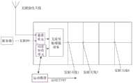
本发明实施例所示的系统示意图见图2,一种动态补偿的卫星导航定位增强系统,包括依次连接的可接收外部卫星信号的基准单元、卫星导航增强设备、发射天线,还包括一动态补偿单元,所述动态补偿单元与卫星导航增强设备连接,所述卫星导航增强设备根据所述基准单元和动态补偿单元分别提供的时间信息和运动载体的位置与动态补偿信息实时再生动态卫星导航定位增强信号,并通过所述发射天线进行播发。运动载体的位置与动态补偿信息,通常包括运动载体的位置和速度。本发明通过增设动态补偿单元为卫星导航增强设备提供运动载体的位置与动态补偿,运动载体在运动方向上以V速度行进,通过动态补偿单元不断连续跟踪其位置与动态补偿信息给卫星导航增强设备,进而构建运动载体的位置与动态补偿信息与卫星导航增强设备的再生动态卫星导航定位增强信号形成实时闭环,在运动载体方向上通过发射天线1、发射天线2……发射天线N不断连续发射动态的再生卫星导航定位增强信号,以对运动载体进行精准定位,解决了无需对现有运动载体上的导航终端进行任何改动,尤其满足高速运动载体实现隧道内精准卫星导航定位的问题,对隧道内交通事故应急救援、预防二次事故以及降低隧道内重大事故风险具有重要应用价值。The schematic diagram of the system shown in the embodiment of the present invention is shown in Figure 2, a satellite navigation and positioning enhancement system with dynamic compensation, including a reference unit that can receive external satellite signals, satellite navigation enhancement equipment, and a transmitting antenna connected in sequence, and also includes a dynamic compensation unit, the dynamic compensation unit is connected to the satellite navigation enhancement device, and the satellite navigation enhancement device regenerates the dynamic satellite navigation positioning enhancement in real time according to the time information provided by the reference unit and the dynamic compensation unit respectively, the position of the moving carrier and the dynamic compensation information signal and broadcast it through the transmitting antenna. The position and dynamic compensation information of the moving carrier usually includes the position and speed of the moving carrier. The present invention provides the position and dynamic compensation of the moving carrier for the satellite navigation enhancing equipment by adding a dynamic compensation unit, and the moving carrier travels at a speed of V in the moving direction, and continuously tracks its position and dynamic compensation information to the satellite navigation enhancing equipment through the dynamic compensation unit , and then construct the position and dynamic compensation information of the moving carrier and the regenerated dynamic satellite navigation and positioning enhanced signal of the satellite navigation enhancement equipment to form a real-time closed loop, and continuously transmit the dynamic The regenerative satellite navigation and positioning enhanced signal is used to accurately locate the moving carrier, which solves the problem of no need to make any changes to the navigation terminal on the existing moving carrier, especially to meet the high-speed moving carrier to achieve accurate satellite navigation and positioning in the tunnel. It has important application value in emergency rescue of traffic accidents, prevention of secondary accidents and reduction of major accident risks in tunnels.
结合图2和图3所示,本实施例中的基准单元包括GNSS信号接收模块,其GNSS信号接收模块为设置在隧道口外的无源接收天线,无源接收天线用于接收真实GNSS信号,通过射频接口与卫星导航增强设备连接,即把相关的GNSS信号发送给卫星导航增强设备中的即时接收单元,即时接收单元通过对GNSS信号进行解析,优选的,无源接收天线可以为双模接收天线,在我国机车上的导航终端通常为BDS系统或GPS系统,因此能满足接收BDS信号,和/或GPS信号,即可满足本系统的需求。本实施例中,GNSS信号接收模块也可以认为内置在卫星导航增强设备中。As shown in Fig. 2 and Fig. 3, the reference unit in this embodiment includes a GNSS signal receiving module, and its GNSS signal receiving module is a passive receiving antenna arranged outside the tunnel mouth, and the passive receiving antenna is used to receive real GNSS signals, through The radio frequency interface is connected with the satellite navigation enhancement device, that is, the relevant GNSS signal is sent to the instant receiving unit in the satellite navigation enhancement equipment, and the instant receiving unit analyzes the GNSS signal. Preferably, the passive receiving antenna can be a dual-mode receiving antenna , the navigation terminal on locomotives in our country is usually BDS system or GPS system, so it can meet the requirements of this system by receiving BDS signals and/or GPS signals. In this embodiment, the GNSS signal receiving module can also be considered to be built in the satellite navigation enhancement device.
本实施例中的基准单元也可以安装在室内,且包括网络模块,通过互联网请求GNSS数据服务器获取星历、历书等星座参数信息和基准时间信息,并将星座参数信息和基准时间信息转发至卫星导航增强设备中,通过互联网首次获取的星历、历书等星座参数信息和基准时间信息的速度快于无源接收天线的速度,而且能获取全部的卫星信息,以供卫星导航增强设备进行多个卫星的选星组合,快速再生卫星导航定位增强信号。The reference unit in this embodiment can also be installed indoors, and includes a network module, requests the GNSS data server to obtain constellation parameter information such as ephemeris and almanac and reference time information through the Internet, and forwards the constellation parameter information and reference time information to the satellite In the navigation enhancement equipment, the speed of constellation parameter information and reference time information such as ephemeris and almanac obtained for the first time through the Internet is faster than the speed of the passive receiving antenna, and all satellite information can be obtained for the satellite navigation enhancement equipment to carry out multiple The combination of satellite selection and fast regeneration of satellite navigation and positioning enhanced signals.
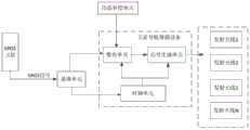
本实施例中,卫星导航增强设备包括时频单元、数仿单元、信号生成单元,所述时频单元触发数仿单元进行卫星信号数据仿真,且时频单元同时注入到信号生成单元对接收到卫星信号仿真数据进行卫星导航定位增强信号实时再生,在本实施例中进一步地描述,如图4所示本发明的时频单元示意图,时频单元包括依次连接的GNSS信号时钟驯服模块、本地时钟产生模块,GNSS信号时钟驯服模块内置GNSS信号接收机和驯服控制子单元和频率发生器件,GNSS信号接收机实时接收GNSS卫星时间信息,输出至驯服控制子单元,驯服控制子单元根据所述时间信息对频率发生器件生成的本地时频基准信号进行驯服,有效提升了频率发生器件的频率准确性;频率发生器件输出驯服后的本地时频基准信号至所述本地时钟产生模块,本地时钟产生模块同步产生本地时钟信号,并驱动和分频生成如数仿单元、信号生成单元、发射单元所需的频标信号,可以保障再生的卫星导航定位增强信号同步的可靠性,保证生成的本地时频基准信号(10MHz和1PPS)与外部真实GNSS卫星系统的时间同步,通过时频传递,从而保证再生的卫星导航定位增强信号与外部真实GNSS卫星信号同步。此外,GNSS信号时钟驯服模块还可以内置接口,方便用户查询工作状态、授时质量等,以保证导航终端实现连续导航。In this embodiment, the satellite navigation enhancement device includes a time-frequency unit, a digital simulation unit, and a signal generation unit. The time-frequency unit triggers the digital simulation unit to perform satellite signal data simulation, and the time-frequency unit is injected into the signal generation unit at the same time. Satellite signal simulation data carries out satellite navigation positioning enhanced signal real-time regeneration, further described in the present embodiment, time-frequency unit schematic diagram of the present invention as shown in Fig. Generation module, GNSS signal clock taming module built-in GNSS signal receiver, taming control subunit and frequency generating device, GNSS signal receiver receives GNSS satellite time information in real time, outputs to taming control subunit, taming control subunit according to the time information Taming the local time-frequency reference signal generated by the frequency generation device effectively improves the frequency accuracy of the frequency generation device; the frequency generation device outputs the tamed local time-frequency reference signal to the local clock generation module, and the local clock generation module is synchronized Generate a local clock signal, and drive and divide frequency to generate the frequency standard signal required by the digital simulation unit, signal generation unit, and transmitting unit, which can ensure the reliability of the regenerated satellite navigation and positioning, enhance signal synchronization, and ensure the generated local time-frequency reference The signal (10MHz and 1PPS) is synchronized with the time of the external real GNSS satellite system, and transmitted through time-frequency, so as to ensure that the regenerated satellite navigation and positioning enhanced signal is synchronized with the external real GNSS satellite signal. In addition, the GNSS signal clock taming module can also have a built-in interface, which is convenient for users to query the working status, timing quality, etc., so as to ensure that the navigation terminal can realize continuous navigation.
在本实施例中,时频单元还包括控制模块,所述控制模块分别与GNSS信号时钟驯服模块、本地时钟产生模块连接,可以通过控制模块发送频偏指令调节本地时频基准信号的频偏,以及发送触发启动指令给数仿单元以开始计算再生卫星导航信号所需的仿真数据。例如,可以通过网络程控实现对时频基准信号频率的精密微调,实现偏移调整范围±3×10⁻⁶,最小调制步进1×10-13。通过精密微调信号生成参考频率,间接实现再生的卫星导航信号的时间偏移,可有效实现对发射区域或终端的授时精度的渐变精确控制,且不会造成授时结果的波动或大跳动,进一步保证如隧道内外等室内、外的导航终端设备实现连续导航。In this embodiment, the time-frequency unit also includes a control module, the control module is respectively connected with the GNSS signal clock taming module and the local clock generation module, and the frequency offset of the local time-frequency reference signal can be adjusted by sending a frequency offset command through the control module, And sending a trigger start command to the digital simulation unit to start calculating the simulation data required for regenerating the satellite navigation signal. For example, precise fine-tuning of the frequency of the time-frequency reference signal can be realized through network program control, with an offset adjustment range of ±3×10⁻⁶ and a minimum modulation step of 1×10-13 . The reference frequency is generated by fine-tuning the signal to indirectly realize the time offset of the regenerated satellite navigation signal, which can effectively realize the gradual and precise control of the timing accuracy of the launch area or the terminal, and will not cause fluctuations or large jumps in the timing results, further ensuring For example, indoor and outdoor navigation terminal equipment such as inside and outside the tunnel can realize continuous navigation.
本实施例中,动态补偿单元是一种可以测量运动载体位置和速度等补偿信息的装置,通过数据接口与所述卫星导航增强设备中的数仿单元连接。动态补偿单元可以为激光测速仪、雷达测速仪或超声波测速仪,只要能实现快速对运动载体进行位置和速度测量的仪器都在本发明保护的范围内。在高速行进列车的隧道内卫星导航定位增强应用中,尤其重要,因为高速列车与普通列车或者公路汽车不同,高速运行的列车行驶速度按300~400km/h来估算的话,单秒行走距离约80~120米左右。在如此高速运动下,为了保证再生的卫星导航信号能够被其有效接收,且要保证定位精度满足定位需求,常规的室内定位增强方案无法满足其需求。通过本动态补偿单元实时对行进高速列车轨迹进行连续探测跟踪,然后将获取到高速列车的位置和速度等补偿信息反馈至卫星导航增强设备中的数仿单元,即卫星导航增强设备将依据收到的补偿信息进行实时解算与调整后,构建与其相一致的动态场景信号,从而形成一个隧道内的再生的动态卫星导航增强信号的实时闭环系统。高速列车最终的定位误差与该动态补偿单元所测误差为同一量级。本动态补偿单元可以在隧道入口处或者与卫星导航增强设备组合进行布设,例如在隧道内距离隧道入口的300m或500m左右对即将进入隧道的高速列车进行速度、位置检测,并将该300m或500m内的高速列车的动态补偿信息及时发送给卫星导航增强设备中的数仿单元,数仿单元根据该补偿信息进行实时动态闭环调整与高速列车上相匹配的BDS或GPS信号再生所需的卫星导航观测数据模拟量,以此默认在隧道内,该高速列车作匀速运动,根据匀速的运动速度信息、位置信息实时闭环生成BDS或GPS的卫星导航信号仿真数据,即信号生成单元根据该卫星导航信号仿真数据再生为卫星导航定位增强信号。当然,由于隧道有弯曲路线或者隧道内有上下高度差的情况,高速列车在隧道内做变速运动,因此最优方式,是在全隧道内,间隔布置多个动态补偿单元,以实时检测高速列车在隧道内行进的位置和位置等动态信息,实现再生出更加精确的卫星导航定位增强信号,满足动态高速列车在隧道内的精准定位,为车站指挥调动、监管提供了精准位置信息。In this embodiment, the dynamic compensation unit is a device that can measure compensation information such as the position and speed of the moving carrier, and is connected to the digital simulation unit in the satellite navigation enhancement device through a data interface. The dynamic compensation unit can be a laser velocimeter, a radar velocimeter or an ultrasonic velocimeter, as long as the instrument can quickly measure the position and speed of the moving carrier, it is within the protection scope of the present invention. It is especially important in the application of satellite navigation and positioning enhancement in tunnels of high-speed trains, because high-speed trains are different from ordinary trains or road vehicles. If the speed of a high-speed train is estimated at 300-400km/h, the single-second walking distance is about 80 ~120 meters or so. Under such high-speed motion, in order to ensure that the regenerated satellite navigation signal can be effectively received by it, and to ensure that the positioning accuracy meets the positioning requirements, the conventional indoor positioning enhancement scheme cannot meet its needs. Through this dynamic compensation unit, the trajectory of the moving high-speed train is continuously detected and tracked in real time, and then the compensation information such as the position and speed of the high-speed train is fed back to the digital simulation unit in the satellite navigation enhancement device, that is, the satellite navigation enhancement device will be based on the received After real-time calculation and adjustment of the compensation information, a dynamic scene signal consistent with it is constructed, thereby forming a real-time closed-loop system of regenerated dynamic satellite navigation enhanced signals in the tunnel. The final positioning error of the high-speed train is of the same magnitude as the error measured by the dynamic compensation unit. The dynamic compensation unit can be deployed at the tunnel entrance or combined with satellite navigation enhancement equipment, for example, in the tunnel about 300m or 500m away from the tunnel entrance, the speed and position of the high-speed train that is about to enter the tunnel are detected, and the 300m or 500m The dynamic compensation information of the high-speed train in the system is sent to the digital simulation unit in the satellite navigation enhancement device in time, and the digital simulation unit performs real-time dynamic closed-loop adjustment according to the compensation information and the satellite navigation required for the regeneration of the BDS or GPS signal matched with the high-speed train Observation data simulation, so the high-speed train moves at a constant speed in the tunnel by default, and generates BDS or GPS satellite navigation signal simulation data in real time in a closed-loop manner according to the uniform speed information and position information, that is, the signal generation unit uses the satellite navigation signal The simulation data is reproduced as a satellite navigation and positioning enhanced signal. Of course, because the tunnel has a curved route or there is a height difference between the upper and lower sides of the tunnel, the high-speed train moves at variable speeds in the tunnel. Therefore, the optimal way is to arrange multiple dynamic compensation units at intervals in the entire tunnel to detect high-speed trains in real time. The dynamic information such as the location and location of the travel in the tunnel realizes the reproduction of more accurate satellite navigation and positioning enhanced signals, which meets the precise positioning of dynamic high-speed trains in the tunnel, and provides precise location information for station command, mobilization and supervision.
本实施例中,卫星导航增强设备可以与N个发射天线通过网络直接或间接连接,N个发射天线将所述卫星导航增强设备再生的N个卫星导航信号往隧道内等室内发射,即该卫星导航增强设备中有多个射频通道,通过对不同道道与不同发射天线的匹配,可实现一个卫星导航增强设备可以与多个发射天线进行连接,从而减少卫星导航增强设备的配置与安装成本。In this embodiment, the satellite navigation enhancement device can be directly or indirectly connected to the N transmitting antennas through the network, and the N transmission antennas transmit the N satellite navigation signals regenerated by the satellite navigation enhancement equipment to indoors such as tunnels, that is, the satellite There are multiple radio frequency channels in the navigation enhancement equipment. By matching different channels and different transmitting antennas, one satellite navigation enhancement equipment can be connected with multiple transmission antennas, thereby reducing the configuration and installation costs of satellite navigation enhancement equipment.
优选地,N个所述发射天线呈间距线性分布、或呈网格矩阵式分布,发射天线间隔300m~500m,间距也可以都是等距的,也可以根据现场布置需求而定。具体的,可以通过与运动载体的位置与动态补偿信息进行匹配,分发精准的再生卫星导航定位增强信号,即发射天线虽然是间距固定设置的,但再生的卫星导航定位增强信号是随运动的高速列车实时随动的,因此通过本发明实施,本隧道内再生的卫星导航定位增强信号是实时连续的,实现高速列车在隧道内的精准定位。本系统建设具有难度小、成本低、通用化以及支持北斗、GPS多系统,导航定位精度高等优点。Preferably, the N transmitting antennas are distributed linearly or in a grid matrix, and the spacing between the transmitting antennas is 300m-500m, and the spacing can also be equidistant, or can be determined according to site layout requirements. Specifically, by matching with the position of the moving carrier and dynamic compensation information, the accurate regenerated satellite navigation and positioning enhanced signal can be distributed. The train follows in real time, so through the implementation of the present invention, the satellite navigation positioning enhancement signal regenerated in the tunnel is continuous in real time, realizing the precise positioning of the high-speed train in the tunnel. The construction of this system has the advantages of low difficulty, low cost, generalization, support for Beidou and GPS multi-systems, and high navigation and positioning accuracy.
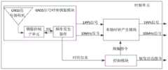
如图5所示本发明实施例的数仿单元至信号生成单元示意图,信号生成单元包括N个基带信号单元,N个所述基带信号单元对应N个射频输出端口,所述基带信号单元根据所述时频单元提供的同一时钟进行上变频直接输出射频信号由N个发射天线进行播发。数仿单元根据卫星星座参数信息和发射天线所在的位置信息进行组合计算仿真,更为优选的是,将相邻的发射天线对应不同的卫星星座参数信息,以此减少相邻卫星导航信号之间的干扰,数仿将民码序列生成N路仿真数据至N个基带信号单元,其中N个发射天线,与N个射频输出端口一一对应,以此实现N个卫星导航信号既同步又不相干扰的独立输出,实现室内环境下的卫星导航信号的连续导航。具体的,1≤N≤16。优先选择8通道多路信号输出。As shown in Figure 5, a schematic diagram of the digital simulation unit to the signal generation unit of the embodiment of the present invention, the signal generation unit includes N baseband signal units, and the N baseband signal units correspond to N radio frequency output ports, and the baseband signal units are based on the set The same clock provided by the time-frequency unit is up-converted and directly output radio frequency signals are broadcasted by N transmitting antennas. The digital simulation unit performs combined calculation and simulation according to the satellite constellation parameter information and the location information of the transmitting antenna. More preferably, the adjacent transmitting antennas correspond to different satellite constellation parameter information, so as to reduce the distance between adjacent satellite navigation signals. interference, the digital simulation will generate N channels of simulation data from the civilian code sequence and send them to N baseband signal units, among which N transmitting antennas correspond to N radio frequency output ports one by one, so as to realize that the N satellite navigation signals are both synchronous and out of phase The independent output of interference realizes the continuous navigation of the satellite navigation signal in the indoor environment. Specifically, 1≤N≤16. 8-channel multi-signal output is preferred.
进一步地,数仿单元可根据N个发射天线的位置结合N种选星组合进行数据仿真,所述信号生成单元根据N个仿真数据生成N个卫星导航信号。Further, the digital simulation unit can perform data simulation according to the positions of the N transmitting antennas in combination with N kinds of satellite selection combinations, and the signal generation unit generates N satellite navigation signals according to the N simulation data.
本实施例中,一个数仿单元对应N个基带信号单元,当数仿单元为M个时,则对应M*N个基带信号单元,比如数仿单元可任意选择BDS、GPS、GLONASS、Galileo任意一种或多种卫星导航体系组合计算仿真数据,从而生成M*N个任意GNSS信号,即任意一种GNSS信号可以选择多个通道并行独立输出,以满足多个体制信号发射的需要,能满足隧道内装有BDS、GPS、GLONASS、Galileo任意体系的车载导航终端,均能进行连续导航,不存在盲区与死区,进一步的,由于本实施例中,数仿单元是根据动态补偿单元实时提供的运动载体的位置与动态等补偿信息构建动态的卫星导航观测数据,即信号生成单元再生的卫星导航定位增强信号也是不同的,根据不同通道输出,即间隔布置的发射天线之间的卫星导航定位增强信号是不同的,因此也克服了发射天线之间的远近效应、串扰和邻扰等问题。In this embodiment, one digital simulation unit corresponds to N baseband signal units. When there are M number of digital simulation units, it corresponds to M*N baseband signal units. For example, the digital simulation unit can arbitrarily select BDS, GPS, GLONASS, Galileo One or more satellite navigation systems combine and calculate simulation data to generate M*N arbitrary GNSS signals, that is, any GNSS signal can select multiple channels to output in parallel and independently to meet the needs of multiple systems for signal transmission, and can meet The vehicle-mounted navigation terminal of any system of BDS, GPS, GLONASS, Galileo is equipped with in the tunnel, all can carry on continuous navigation, there is no blind zone and dead zone, further, because in this embodiment, the digital imitation unit is provided in real time according to the dynamic compensation unit Compensation information such as the position and dynamics of the moving carrier constructs dynamic satellite navigation observation data, that is, the satellite navigation and positioning enhancement signals regenerated by the signal generation unit are also different, and are output according to different channels, that is, the satellite navigation and positioning enhancement between the transmitting antennas arranged at intervals The signals are distinct, thus overcoming near-far effects, cross-talk, and neighbor-to-neighbor issues between transmit antennas.
本发明还提供一种动态补偿的卫星导航定位增强方法,如图6所示,包括以下步骤:实时接收真实GNSS卫星导航信号,解算真实GNSS卫星导航信号中的时间信息和星座参数信息,将所得的时间信息送至时频单元,将所得的星座参数信息送至数仿单元;检测运动载体的位置和动态等补偿信息,将所述补偿信息送至数仿单元;时频单元同步触发数仿单元和信号生成单元,所述数仿单元根据所述星座参数信息和补偿信息计算所需再生卫星导航信号的仿真数据;根据所述仿真数据实时再生卫星导航定位增强信号,并进行播发。本实施例中,可以通过无源接收天线接收外部真实的GNSS信号,可以将实时解算GNSS信号中的时间信息用于给时频单元提供与真实卫星信号的时间频率一致的时频基准,以此保证隧道等环境下的N个卫星导航定位增强信号是与室外的卫星信号保持同步的,实现隧道内外导航信号无缝切换,特别是通过对运动载体的位置和动态等补偿信息进行检测,可实时将该运动载体的补偿信息与接收的星座参数信息构成实时闭环的卫星导航仿真数据,信号生成单元根据该仿真数据实时再生卫星导航定位增强信号,并在隧道室内进行播发,从而保证了隧道室内外的导航信号的动态连续性,因此,本实施例中,运动载体导航终端因导航信号动态连续实现精准定位。The present invention also provides a satellite navigation positioning enhancement method with dynamic compensation, as shown in Figure 6, comprising the following steps: receiving real GNSS satellite navigation signals in real time, solving time information and constellation parameter information in the real GNSS satellite navigation signals, and The obtained time information is sent to the time-frequency unit, and the obtained constellation parameter information is sent to the digital simulation unit; the compensation information such as the position and dynamics of the moving carrier is detected, and the compensation information is sent to the digital simulation unit; the time-frequency unit triggers data synchronously. A simulation unit and a signal generation unit, the digital simulation unit calculates the simulation data of the satellite navigation signal to be regenerated according to the constellation parameter information and the compensation information; regenerates the satellite navigation positioning enhanced signal in real time according to the simulation data, and broadcasts it. In this embodiment, the external real GNSS signal can be received through the passive receiving antenna, and the time information in the real-time solution GNSS signal can be used to provide the time-frequency unit with a time-frequency reference consistent with the time-frequency of the real satellite signal, so as to This ensures that the N satellite navigation and positioning enhancement signals in environments such as tunnels are synchronized with outdoor satellite signals, and seamless switching of navigation signals inside and outside the tunnel is realized, especially by detecting the compensation information such as the position and dynamics of the moving carrier. The compensation information of the moving carrier and the received constellation parameter information constitute real-time closed-loop satellite navigation simulation data in real time, and the signal generation unit regenerates the satellite navigation and positioning enhanced signal in real time according to the simulation data, and broadcasts it in the tunnel room, thus ensuring the tunnel indoor The dynamic continuity of the external navigation signal, therefore, in this embodiment, the mobile carrier navigation terminal realizes precise positioning due to the dynamic continuity of the navigation signal.
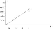
如图7所示,例如在等间距100m位置布设发射天线,与动态补偿单元,通过对行进中的车辆进行位置与动态补偿,实时构建卫星导航仿真动态场景,以高速列车为100m/s的速度匀速行进为例,根据P动=P0+V*T,其中P0视为列车被检测到的初始位置,P动是随时都在动态变化的,根据列车的速度,得出动态位置信息,从而为卫星导航增强设备构建实时闭环动态场景的卫星导航仿真数据,即生成连续的与列车随动的动态的卫星导航定位增强信号,即高速行驶的车辆在任何时间段都能接收到连续的动态的卫星导航定位增强信号。As shown in Figure 7, for example, the transmitting antennas are arranged at equal intervals of 100m, and the dynamic compensation unit is used to compensate the position and dynamics of the moving vehicles to construct a satellite navigation simulation dynamic scene in real time. The speed of the high-speed train is 100m/s Taking uniform speed as an example, according to Pmotion =P0 +V*T, where P0 is regarded as the initial position of the train being detected, and Pmotion is dynamically changing at any time. According to the speed of the train, the dynamic position information is obtained. In order to build real-time closed-loop dynamic satellite navigation simulation data for satellite navigation enhancement equipment, that is, to generate continuous dynamic satellite navigation positioning enhancement signals that follow the train, that is, high-speed vehicles can receive continuous dynamic signals at any time. The satellite navigation and positioning enhanced signal.
本实施中,还可通过互联网获取GNSS信号中的时间信息以及星历、历书等星座参数信息,将所述星座参数信息送至数仿单元,将所述时间信息送至时频单元。其中星座参数信息精确地描述了卫星的轨道参数信息,用于数仿单元的仿真导航电文数据;检测运动载体的位置和动态信息以及星座参数信息在数仿单元中仿真导航观测数据,导航电文数据与导航观测数据形成所要再生的卫星导航定位增强信号的仿真数据,进而信号生成单元根据该仿真数据实时再生卫星导航定位增强信号,并在隧道室内进行播发,从而保证了隧道室内外的导航信号的动态连续性。In this implementation, the time information in the GNSS signal and constellation parameter information such as ephemeris and almanac can also be obtained through the Internet, and the constellation parameter information is sent to the digital simulation unit, and the time information is sent to the time-frequency unit. Among them, the constellation parameter information accurately describes the orbital parameter information of the satellite, which is used for the simulation navigation message data of the digital simulation unit; the position and dynamic information of the detected moving carrier and the constellation parameter information are used to simulate the navigation observation data and navigation message data in the digital simulation unit The simulation data of the satellite navigation and positioning enhanced signal to be reproduced is formed with the navigation observation data, and then the signal generation unit regenerates the satellite navigation and positioning enhanced signal in real time according to the simulation data, and broadcasts in the tunnel room, thus ensuring the accuracy of the navigation signal inside and outside the tunnel. dynamic continuity.
进一步地,还设有监测所述再生卫星导航定位增强信号播发状态的步骤,以验证运动载体位置与动态补偿信息到再生动态卫星导航定位增强信号的正确性,根据监测反馈所需的再生动态卫星导航定位增强信号的正确性,可对各信号产生环节及时进行调整,以形成更大的实时闭环。当然,也可以为了对该隧道内增强系统运行状态进行实时监控和远程维护,布设监控软件平台,该平台可与铁路监控系统进行集成应用,可以实时掌握隧道内的列车运行状况,在紧急情况下可以及时制定指挥策略。Further, there is also a step of monitoring the broadcast status of the regenerated satellite navigation and positioning enhanced signal to verify the correctness of the moving carrier position and dynamic compensation information to the regenerated dynamic satellite navigation and positioning enhanced signal, and according to the regenerated dynamic satellite required for monitoring feedback Navigation and positioning enhance the correctness of the signal, and can adjust each signal generation link in time to form a larger real-time closed loop. Of course, for real-time monitoring and remote maintenance of the operating status of the enhanced system in the tunnel, a monitoring software platform can also be deployed. This platform can be integrated with the railway monitoring system to grasp the operating status of the train in the tunnel in real time. Command strategies can be formulated in a timely manner.
当然,本实施例还设有调节卫星导航信号的功率,以增大或衰减播发的卫星导航信号的功率,用于在信号播发前调节卫星导航仿真信号强度,以确保隧道内行驶车辆接收卫星导航定位增强信号强度的一致性和平稳性。Of course, this embodiment also has the function of adjusting the power of the satellite navigation signal to increase or attenuate the power of the broadcast satellite navigation signal, and is used to adjust the strength of the satellite navigation simulation signal before the signal is broadcast, so as to ensure that the vehicles driving in the tunnel receive the satellite navigation signal. Positioning enhances the consistency and stationarity of signal strength.
综上,本发明适用于所有隧道等室内环境下需对运动载体如高速列车、列车、汽车提供有效的卫星导航定位增强,实现精准定位。通过本发明的卫星导航定位增强系统,导航突变引发的不连续问题都迎刃而解,应用前景非常广泛。To sum up, the present invention is applicable to provide effective satellite navigation and positioning enhancement for moving carriers such as high-speed trains, trains, and automobiles in indoor environments such as tunnels to achieve precise positioning. Through the satellite navigation positioning enhancement system of the invention, the discontinuity problems caused by navigation mutations are all solved, and the application prospect is very wide.
虽然本发明已以较佳实施例揭示如上,然而并非用以限定本发明。任何熟悉本领域的技术人员,在不脱离本发明技术方案范围的情况下,都可利用上述揭示的技术内容对本发明技术方案做出许多可能的变动和修饰,或修改为等同变化的等效实施例。因此,凡是未脱离本发明技术方案的内容,依据本发明技术实质对以上实施例所做的任何简单修改、等同变化及修饰,均应落在本发明技术方案保护的范围内。Although the present invention has been disclosed above with preferred embodiments, it is not intended to limit the present invention. Any person familiar with the art, without departing from the scope of the technical solution of the present invention, can use the technical content disclosed above to make many possible changes and modifications to the technical solution of the present invention, or modify it into an equivalent implementation of equivalent changes example. Therefore, any simple modifications, equivalent changes and modifications made to the above embodiments according to the technical essence of the present invention shall fall within the protection scope of the technical solution of the present invention.
Claims (10)
Priority Applications (1)
| Application Number | Priority Date | Filing Date | Title |
|---|---|---|---|
| CN201710617675.4ACN107219535B (en) | 2017-07-26 | 2017-07-26 | A dynamic compensation satellite navigation positioning enhancement system and method |
Applications Claiming Priority (1)
| Application Number | Priority Date | Filing Date | Title |
|---|---|---|---|
| CN201710617675.4ACN107219535B (en) | 2017-07-26 | 2017-07-26 | A dynamic compensation satellite navigation positioning enhancement system and method |
Publications (2)
| Publication Number | Publication Date |
|---|---|
| CN107219535A CN107219535A (en) | 2017-09-29 |
| CN107219535Btrue CN107219535B (en) | 2023-05-05 |
Family
ID=59954013
Family Applications (1)
| Application Number | Title | Priority Date | Filing Date |
|---|---|---|---|
| CN201710617675.4AActiveCN107219535B (en) | 2017-07-26 | 2017-07-26 | A dynamic compensation satellite navigation positioning enhancement system and method |
Country Status (1)
| Country | Link |
|---|---|
| CN (1) | CN107219535B (en) |
Families Citing this family (11)
| Publication number | Priority date | Publication date | Assignee | Title |
|---|---|---|---|---|
| CN107462906A (en)* | 2017-07-24 | 2017-12-12 | 湖南国科防务电子科技有限公司 | A kind of method and system based on Big Dipper satellite signal regeneration gps signal |
| CN109738927A (en)* | 2018-12-14 | 2019-05-10 | 湖南卫导信息科技有限公司 | Navigation signal continuously-positioning system and method inside and outside tunnel |
| CN111381261B (en)* | 2018-12-29 | 2022-05-27 | 广州市泰斗电子科技有限公司 | Positioning resolving method and device and satellite navigation receiver |
| CN110632631B (en)* | 2019-09-23 | 2023-07-04 | 四川中电昆辰科技有限公司 | Special vehicle-mounted GNSS signal compensation device, positioning system and method |
| CN110632630B (en)* | 2019-09-23 | 2023-07-04 | 四川中电昆辰科技有限公司 | Vehicle-mounted GNSS signal compensation device, positioning system and method |
| CN111812690B (en)* | 2020-08-28 | 2021-01-05 | 长沙北斗产业安全技术研究院有限公司 | Blind dynamic satellite navigation signal generation method and system |
| CN112098932B (en)* | 2020-09-22 | 2024-05-03 | 杭州海康威视数字技术股份有限公司 | Positioning system, signal transmitting equipment and signal receiving method |
| CN113067622B (en)* | 2021-02-25 | 2022-08-12 | 上海卫星工程研究所 | Composite scene multi-source signal generation autonomous deviation correcting device and method |
| CN115225135B (en)* | 2021-04-20 | 2023-12-29 | 大唐移动通信设备有限公司 | Signal transmission method and device and readable storage medium |
| CN114460603A (en)* | 2022-01-21 | 2022-05-10 | 杭州北斗时空研究院 | GNSS augmentation system suitable for tunnel environment |
| CN115524724B (en)* | 2022-11-25 | 2023-04-18 | 长沙北斗产业安全技术研究院股份有限公司 | General aviation credible space-time service method, system and medium |
Family Cites Families (8)
| Publication number | Priority date | Publication date | Assignee | Title |
|---|---|---|---|---|
| US6246960B1 (en)* | 1998-11-06 | 2001-06-12 | Ching-Fang Lin | Enhanced integrated positioning method and system thereof for vehicle |
| EP1706756A2 (en)* | 2004-01-15 | 2006-10-04 | The Boeing Company | Methods and systems for enhanced navigational performance |
| US8725327B2 (en)* | 2008-04-22 | 2014-05-13 | Exelis Inc. | Navigation system and method of obtaining accurate navigational information in signal challenging environments |
| US9612341B2 (en)* | 2012-12-28 | 2017-04-04 | Trimble Inc. | GNSS receiver positioning system |
| EP3191795A1 (en)* | 2014-09-08 | 2017-07-19 | InvenSense, Inc. | Method and apparatus for using map information aided enhanced portable navigation |
| CN106226784B (en)* | 2016-06-27 | 2019-02-01 | 广东工业大学 | Reference base station intelligent dynamic management system and method in satellite positioning enhancing system |
| CN106980122A (en)* | 2017-04-07 | 2017-07-25 | 湖南国科防务电子科技有限公司 | Satellite navigation positioning strengthening system and method under indoor environment |
| CN207020313U (en)* | 2017-07-26 | 2018-02-16 | 湖南国科防务电子科技有限公司 | A kind of satellite navigation positioning strengthening system of dynamic compensation |
- 2017
- 2017-07-26CNCN201710617675.4Apatent/CN107219535B/enactiveActive
Non-Patent Citations (3)
| Title |
|---|
| 施浒立 ; 李林 ; .卫星导航增强系统讨论.导航定位与授时.2015,第02卷(第05期),第30-36页.* |
| 杨波 ; 王跃钢 ; 徐洪涛 ; .高速飞行环境下卫星导航信息滞后补偿方法.中国惯性技术学报.2011,第19卷(第03期),第293-297页.* |
| 赵军 ; 王继龙 ; 吴建平 ; .基于互联网的导航定位增强信息大规模实时播发研究.宇航学报.2006,第27卷(第04期),第819-823页.* |
Also Published As
| Publication number | Publication date |
|---|---|
| CN107219535A (en) | 2017-09-29 |
Similar Documents
| Publication | Publication Date | Title |
|---|---|---|
| CN107219535B (en) | A dynamic compensation satellite navigation positioning enhancement system and method | |
| CN106355928B (en) | A kind of bus or train route collaboration DAS (Driver Assistant System) and method based on wireless location | |
| CN102358333B (en) | Wireless signal system for preventing rapid trains from rear-end collision | |
| CN100511310C (en) | Virtual block system based on radio signal of locomotive | |
| CN106143538B (en) | A kind of train locating method based on LTE R of utilization double-movement platform | |
| US20230278603A1 (en) | Light train control system applied to oversea freight railways | |
| US10571578B2 (en) | System including base stations that provide information from which a mobile station can determine its position | |
| CN112009522B (en) | Train control system and method for mountain track | |
| CN105676249A (en) | Navigation airplane communication navigation monitoring system and method based on 4G/3G/BDS | |
| CN213323137U (en) | UWB positioning system for improving positioning precision of subway train | |
| CN110082784A (en) | Beidou tunnel covering system and distribution method | |
| CN206696431U (en) | Satellite navigation positions strengthening system under indoor environment | |
| CN114475707A (en) | A train control system for C3 high-speed railway EMUs using the detour running of the ordinary speed line | |
| CN115973228A (en) | Train space-time positioning and three-dimensional multi-dimensional communication, occupancy check and system synchronization method | |
| CN110824523B (en) | Tunnel positioning device based on global satellite positioning navigation system | |
| CN110667651A (en) | Train autonomous operation management system based on high-precision position | |
| CN101071527A (en) | Highway automatic navigation system | |
| CN115042838A (en) | Train potential tracking early warning method based on train-to-vehicle communication system | |
| CN207020313U (en) | A kind of satellite navigation positioning strengthening system of dynamic compensation | |
| Lehner et al. | Measurement and analysis of the direct train to train propagation channel in the 70 cm UHF-band | |
| CN102632912A (en) | Anti-collision early-warning system and method for subway trains | |
| CN114460833B (en) | Driving equipment and timing methods, ground signaling equipment and timing systems | |
| RU2476342C1 (en) | Method and device for data exchange via radio channel between train locomotive and stationary relay station | |
| CN211252601U (en) | Intelligent comprehensive management and control system for metro vehicle base | |
| CN104271389B (en) | Method and apparatus for determining the active power stream in electric power railway current power supply network |
Legal Events
| Date | Code | Title | Description |
|---|---|---|---|
| PB01 | Publication | ||
| PB01 | Publication | ||
| SE01 | Entry into force of request for substantive examination | ||
| SE01 | Entry into force of request for substantive examination | ||
| TA01 | Transfer of patent application right | ||
| TA01 | Transfer of patent application right | Effective date of registration:20211125 Address after:410000 4th floor, building 16, phase I, headquarters building, Changsha Zhongdian Software Park, No. 39, Jianshan Road, high tech Development Zone, Changsha City, Hunan Province Applicant after:CHANGSHA TECHNOLOGY RESEARCH INSTITUTE OF BEIDOU INDUSTRY SAFETY Co.,Ltd. Address before:410205 Room 302, building 16, phase I, Changsha Zhongdian Software Park, No. 39, Jianshan Road, high tech Development Zone, Changsha, Hunan Applicant before:HUNAN GUOKE DEFENSE ELECTRONIC TECHNOLOGY Co.,Ltd. Applicant before:HUNAN TIANXUN BEIDOU INDUSTRIAL SAFETY TECHNOLOGY RESEARCH INSTITUTE CO.,LTD. | |
| CB02 | Change of applicant information | Address after:410000 4th floor, building 16, phase I, headquarters building, Changsha Zhongdian Software Park, No. 39, Jianshan Road, high tech Development Zone, Changsha City, Hunan Province Applicant after:Changsha Beidou Industrial Safety Technology Research Institute Co.,Ltd. Address before:410000 4th floor, building 16, phase I, headquarters building, Changsha Zhongdian Software Park, No. 39, Jianshan Road, high tech Development Zone, Changsha City, Hunan Province Applicant before:CHANGSHA TECHNOLOGY RESEARCH INSTITUTE OF BEIDOU INDUSTRY SAFETY Co.,Ltd. | |
| CB02 | Change of applicant information | ||
| GR01 | Patent grant | ||
| GR01 | Patent grant | ||
| TR01 | Transfer of patent right | ||
| TR01 | Transfer of patent right | Effective date of registration:20240926 Address after:410205 building 16, phase I, Changsha Zhongdian Software Park, No. 39 Jianshan Road, high tech Development Zone, Changsha, Hunan Province Patentee after:HUNAN MATRIX ELECTRONIC TECHNOLOGY Co.,Ltd. Country or region after:China Patentee after:Changsha Beidou Industrial Safety Technology Research Institute Co.,Ltd. Address before:410000 4th floor, building 16, phase I, headquarters building, Changsha Zhongdian Software Park, No. 39, Jianshan Road, high tech Development Zone, Changsha City, Hunan Province Patentee before:Changsha Beidou Industrial Safety Technology Research Institute Co.,Ltd. Country or region before:China | |
| CP03 | Change of name, title or address | ||
| CP03 | Change of name, title or address | Address after:410205 building 16, phase I, Changsha Zhongdian Software Park, No. 39 Jianshan Road, high tech Development Zone, Changsha, Hunan Province Patentee after:HUNAN MATRIX ELECTRONIC TECHNOLOGY Co.,Ltd. Country or region after:China Patentee after:Changsha Beidou Industry Security Technology Research Institute Group Co.,Ltd. Address before:410205 building 16, phase I, Changsha Zhongdian Software Park, No. 39 Jianshan Road, high tech Development Zone, Changsha, Hunan Province Patentee before:HUNAN MATRIX ELECTRONIC TECHNOLOGY Co.,Ltd. Country or region before:China Patentee before:Changsha Beidou Industrial Safety Technology Research Institute Co.,Ltd. |