CN106996783B - A kind of intelligent matching method and device of driving trajectory and road network base map - Google Patents
A kind of intelligent matching method and device of driving trajectory and road network base mapDownload PDFInfo
- Publication number
- CN106996783B CN106996783BCN201610046171.7ACN201610046171ACN106996783BCN 106996783 BCN106996783 BCN 106996783BCN 201610046171 ACN201610046171 ACN 201610046171ACN 106996783 BCN106996783 BCN 106996783B
- Authority
- CN
- China
- Prior art keywords
- road
- area
- coordinates
- driving
- trajectory
- Prior art date
- Legal status (The legal status is an assumption and is not a legal conclusion. Google has not performed a legal analysis and makes no representation as to the accuracy of the status listed.)
- Active
Links
Images


Classifications
- G—PHYSICS
- G01—MEASURING; TESTING
- G01C—MEASURING DISTANCES, LEVELS OR BEARINGS; SURVEYING; NAVIGATION; GYROSCOPIC INSTRUMENTS; PHOTOGRAMMETRY OR VIDEOGRAMMETRY
- G01C21/00—Navigation; Navigational instruments not provided for in groups G01C1/00 - G01C19/00
- G01C21/26—Navigation; Navigational instruments not provided for in groups G01C1/00 - G01C19/00 specially adapted for navigation in a road network
- G01C21/28—Navigation; Navigational instruments not provided for in groups G01C1/00 - G01C19/00 specially adapted for navigation in a road network with correlation of data from several navigational instruments
- G01C21/30—Map- or contour-matching
Landscapes
- Engineering & Computer Science (AREA)
- Radar, Positioning & Navigation (AREA)
- Remote Sensing (AREA)
- Automation & Control Theory (AREA)
- Physics & Mathematics (AREA)
- General Physics & Mathematics (AREA)
- Navigation (AREA)
Abstract
Description
Translated fromChinese技术领域technical field
本发明涉及电子地图领域,具体地说,涉及一种行驶轨迹与路网底图的智能匹配方法及装置。The invention relates to the field of electronic maps, in particular to an intelligent matching method and device of a driving track and a road network base map.
背景技术Background technique
随着科学技术的不断发展,越来越多的电子多媒体技术进入到了人们的日常生活中。其中,电子地图就是其中一个重要的应用领域。With the continuous development of science and technology, more and more electronic multimedia technology has entered people's daily life. Among them, the electronic map is one of the important application areas.
电子地图的前期制作需要投入相应的人员及车辆完成对于道路及行驶轨迹的收集和整理。在现有技术中,绝大多数方案要求作业员在采集时明确某段车采高精度轨迹和底图上的某条道路或实际道路之间的对应关系。但实际在轨迹上逐点与道路进行匹配前,并没有做任何消歧处理,考虑到定位和采集误差等原因,匹配过程中很有可能出现一个轨迹点与两条路段的匹配度较为接近的情况,也可能出现轨迹点与道路1的距离权值最高,而与距离权值略低的道路2的夹角权值更高的情况,这时只依据匹配度选择,有可能导致轨迹上相邻两点所匹配的路段是不同路段,造成地图数据的混乱和错误的发生。The pre-production of electronic maps requires corresponding personnel and vehicles to complete the collection and arrangement of roads and driving trajectories. In the prior art, most solutions require the operator to specify the correspondence between a certain segment of the vehicle's high-precision trajectory and a certain road or actual road on the base map during collection. However, no disambiguation is performed before the actual point-by-point matching with the road on the trajectory. Considering the positioning and acquisition errors, it is very likely that a trajectory point and two road sections have a relatively close matching degree during the matching process. In this case, the distance weight between the trajectory point and the road 1 may also be the highest, and the angle weight between the trajectory point and the road 2 with a slightly lower distance weight is higher. The road segments matched by the two adjacent points are different road segments, causing confusion and errors in the map data.
因此,如何提供一种方法或装置可以进行智能匹配、降低行驶轨迹与道路的偏差是本发明需要解决的技术问题。Therefore, how to provide a method or device that can perform intelligent matching and reduce the deviation between the driving trajectory and the road is a technical problem to be solved by the present invention.
发明内容SUMMARY OF THE INVENTION
有鉴于此,本发明提供了一种行驶轨迹与路网底图的智能匹配方法及装置,实现了基于电子地图数据和实际行驶轨迹的智能计算匹配,大大降低了电子地图与实际行驶轨迹不相同的可能性,提高了电子地图内容的准确性。In view of this, the present invention provides an intelligent matching method and device between the driving track and the road network base map, which realizes the intelligent calculation matching based on the electronic map data and the actual driving track, and greatly reduces the difference between the electronic map and the actual driving track. possibility to improve the accuracy of electronic map content.
一方面,本发明提出一种行驶轨迹与路网底图的智能匹配方法,该方法包括:On the one hand, the present invention proposes an intelligent matching method between a driving trajectory and a road network base map, the method comprising:
分别获取路网底图中道路的坐标和行驶轨迹的数据;Obtain the coordinates of the road and the data of the driving trajectory in the road network base map respectively;
根据所述路网底图中道路属性,判断出某一道路的两端只存在一条可通行道路,则将其串接为路串;According to the road attributes in the road network base map, it is determined that there is only one passable road at both ends of a road, and then it is concatenated into a road string;
若判断出所述路网底图中某一路串的结束点与两条以上的路串通行,则以所述某一路串的结束点与两条以上的路串连接区域构建特征点扩充区域;识别所述特征点扩充区域内的所述行驶轨迹,并确定所述行驶轨迹的核心坐标区域及所述核心坐标区域的中心点;If it is determined that the end point of a certain road string in the road network base map communicates with more than two road strings, then the feature point expansion area is constructed by connecting the end point of the certain road string and more than two road strings; Identifying the driving trajectory in the feature point expansion area, and determining the core coordinate area of the driving trajectory and the center point of the core coordinate area;
根据所述中心点对所述特征点扩充区域内的行驶轨迹进行调整,并与所述路网底图中的相应路串进行匹配。The driving trajectory in the feature point expansion area is adjusted according to the center point, and matched with the corresponding road string in the road network base map.
可选的是,所述判断出某一道路的两端只存在一条可通行道路,则将其串接为路串的步骤包括:Optionally, if it is determined that there is only one passable road at both ends of a certain road, then the step of concatenating them into a road string includes:
判断所述路网底图中第一道路的结束坐标与第二道路的起始坐标是否相同,若相同且第一道路的结束坐标只与第二道路的起始坐标值相同,将所述第一道路和第二道路作为路串;和/或,Determine whether the ending coordinates of the first road and the starting coordinates of the second road are the same in the road network base map. If they are the same and the ending coordinates of the first road are only the same as the starting coordinates of the second road, the a road and a second road as a road string; and/or,
判断所述路网底图中某一路串的结束点与两条以上的路串通行的步骤包括:The step of judging that the end point of a certain road string in the road network base map passes through more than two road strings includes:
判断第一道路的结束坐标与N个道路的起始坐标是否相同,若相同,则确定第一道路的结束坐标和N个道路的起始坐标相邻的扫描区域,将所述扫描区域按照预定面积划分为若干子区域;Determine whether the ending coordinates of the first road and the starting coordinates of the N roads are the same, and if they are the same, determine the scanning area adjacent to the ending coordinates of the first road and the starting coordinates of the N roads, and set the scanning area according to the predetermined The area is divided into several sub-areas;
将经过所述扫描区域的行驶轨迹进行叠加,确定行驶轨迹高概率经过的子区域,作为核心坐标区域;Superimposing the driving trajectories passing through the scanning area, and determining the sub-regions that the driving trajectories pass through with high probability as the core coordinate area;
根据所述核心子区域内的行驶轨迹计算核心行驶中心坐标,将所述扫描区域内的行驶轨迹按照所述核心行驶中心坐标进行调整;Calculate the core driving center coordinates according to the driving trajectory in the core sub-area, and adjust the driving trajectory in the scanning area according to the core driving center coordinates;
获取路网底图道路的两端端点坐标之间的道路形状和距离、以及相对应的行驶轨迹上两个核心行驶中心坐标之间的轨迹形状和距离,判断若两个核心行驶中心属于同一行驶轨迹,且道路和行驶轨迹段的长度比不超过预置的阈值,将所述路网底图的道路和行驶轨迹进行匹配;其中,所述N为大于2的整数。Obtain the road shape and distance between the coordinates of the endpoints at both ends of the road in the road network base map, as well as the trajectory shape and distance between the coordinates of the two core driving centers on the corresponding driving trajectory, and determine if the two core driving centers belong to the same driving track, and the length ratio of the road and the driving track segment does not exceed a preset threshold, the road and the driving track of the road network base map are matched; wherein, the N is an integer greater than 2.
可选的是,所述根据所述核心子区域内的行驶轨迹计算核心行驶中心坐标,将所述扫描区域内的行驶轨迹按照所述核心行驶中心坐标进行调整,具体为:Optionally, calculating the coordinates of the core driving center according to the driving trajectory in the core sub-area, and adjusting the driving trajectory in the scanning area according to the coordinates of the core driving center, specifically:
根据行驶轨迹的坐标确定每个行驶轨迹在所述核心子区域内的行驶轨迹段;Determine the driving track segment of each driving track in the core sub-region according to the coordinates of the driving track;
计算行驶轨迹从所述扫描区域边缘到核心子区域边缘交点的平均方位角;calculating the average azimuth angle of the travel trajectory from the edge of the scan area to the intersection of the edge of the core sub-area;
若两个行驶轨迹之间的平均方位角之差小于预置方位角阈值,且最大投影距离小于预置投影间隔阈值,将两个行驶轨迹中从所述扫描区域边缘到核心子区域边缘的轨迹段作为同一个等价轨迹段;If the difference between the average azimuth angles between the two travel trajectories is smaller than the preset azimuth angle threshold, and the maximum projection distance is smaller than the preset projection interval threshold, the trajectories from the edge of the scanning area to the edge of the core sub-area in the two travel trajectories are divided segment as the same equivalent trajectory segment;
汇总所有的等价轨迹段与所述核心子区域边缘的交点坐标计算核心行驶中心坐标;Summarize the intersection coordinates of all equivalent trajectory segments and the edge of the core sub-region to calculate the core driving center coordinates;
将从所述扫描区域内的行驶轨迹以核心行驶中心坐标为中心进行调整。The driving trajectory from the scanning area is adjusted with the core driving center coordinates as the center.
可选的是,上述行驶轨迹与路网底图的智能匹配方法还包括:Optionally, the intelligent matching method for the above-mentioned driving trajectory and the road network basemap further includes:
查找没有匹配成功的路串,并以所述没有匹配成功的路串为中心设定扩展区域;Find the road string that has not been successfully matched, and set the expansion area with the road string that has not been successfully matched as the center;
获取经过所述中心设定扩展区域内的行驶轨迹,将长度相似比和形状相似比满足预置阈值且处于所述路串的扩展区域内的行驶轨迹,作为与所述路串相匹配的行驶轨迹Acquiring the driving trajectory in the expansion area set by the center, and taking the driving trajectory that meets the preset threshold and is in the expansion area of the road string as the driving trajectory matching the road string track
可选的是,上述行驶轨迹与路网底图的智能匹配方法还包括:Optionally, the intelligent matching method for the above-mentioned driving trajectory and the road network basemap further includes:
若处于相邻路串上的行驶轨迹的端点坐标不相同,计算并判断所述行驶轨迹间的端点坐标的距离是否小于预置端点距离阈值;If the endpoint coordinates of the travel tracks on adjacent road strings are not the same, calculate and determine whether the distance between the endpoint coordinates between the travel tracks is less than a preset endpoint distance threshold;
在所述行驶轨迹间的端点坐标的距离小于预置端点距离阈值时,则根据各行驶轨迹的端点坐标计算中心端点坐标,分别作为相邻路串上的行驶轨迹的新端点坐标。When the distance between the endpoint coordinates of the traveling tracks is less than the preset endpoint distance threshold, the center endpoint coordinates are calculated according to the endpoint coordinates of each traveling track, respectively as the new endpoint coordinates of the traveling tracks on the adjacent road strings.
可选的是,上述行驶轨迹与路网底图的智能匹配方法还包括:Optionally, the intelligent matching method for the above-mentioned driving trajectory and the road network basemap further includes:
所述路网底图中道路与所述行驶轨迹匹配后,根据与所述路网底图路串相匹配的行驶轨迹数据,对所述路网底图的数据进行更新。After the road in the road network base map is matched with the driving track, the data of the road network base map is updated according to the driving track data matched with the road string in the road network base map.
另一方面,为实现上述方法,本发明提出一种行驶轨迹与路网底图的智能匹配装置,该装置包括:On the other hand, in order to realize the above method, the present invention proposes an intelligent matching device for a driving track and a road network base map, the device comprising:
匹配数据获取模块,用于分别获取路网底图中道路的坐标和行驶轨迹的数据;The matching data acquisition module is used to obtain the coordinates of the road and the data of the driving trajectory in the road network base map respectively;
路串构建模块,用于根据所述路网底图中道路属性,判断出某一道路的两端只存在一条可通行道路,则将其串接为路串;The road string building module is used to determine that there is only one passable road at both ends of a certain road according to the road attributes in the road network base map, and then concatenate them into a road string;
路口点匹配模块,用于判断出若所述路网底图中某一路串的结束点与两条以上的路串通行,则以所述某一路串的结束点与两条以上的路串连接区域构建特征点扩充区域;识别所述特征点扩充区域内的所述行驶轨迹,并确定所述行驶轨迹的核心坐标区域及所述核心坐标区域的中心点;根据所述中心点对所述特征点扩充区域内的行驶轨迹进行调整,并与所述路网底图中的相应路串进行匹配。The intersection point matching module is used to determine that if the end point of a certain road string in the road network base map passes through more than two road strings, then the end point of the certain road string is connected with more than two road strings area construction feature point expansion area; identify the driving trajectory in the feature point expansion area, and determine the core coordinate area of the driving trajectory and the center point of the core coordinate area; The driving trajectory in the point expansion area is adjusted and matched with the corresponding road string in the road network base map.
可选的是,所述路串构建模块包括:Optionally, the road string building module includes:
路串道路判断子模块,用于判断所述路网底图中第一道路的结束坐标与第二道路的起始坐标是否相同,若相同且第一道路的结束坐标只与第二道路的起始坐标值相同,将所述第一道路和第二道路作为路串;The road string road judgment sub-module is used to judge whether the end coordinates of the first road and the start coordinates of the second road in the road network base map are the same, if they are the same and the end coordinates of the first road are only the same as the start coordinates of the second road. The initial coordinate values are the same, and the first road and the second road are used as road strings;
路串轨迹匹配子模块,用于获取所述路串上经过的行驶轨迹,并将所述经过的行驶轨迹与所述路串进行匹配。A road string track matching sub-module is used to obtain the travel track passed on the road string, and match the passed travel track with the road string.
可选的是,所述路口点匹配模块,包括:Optionally, the intersection point matching module includes:
子区域划分子模块,用于判断第一道路的结束坐标与N个道路的起始坐标是否相同,若相同,则确定第一道路的结束坐标和N个道路的起始坐标相邻的扫描区域,将所述扫描区域按照预定面积划分为若干子区域;The sub-area division sub-module is used to judge whether the end coordinates of the first road and the start coordinates of the N roads are the same, and if they are the same, determine the scanning area adjacent to the end coordinates of the first road and the start coordinates of the N roads , dividing the scanning area into several sub-areas according to a predetermined area;
核心区域标识子模块,用于将经过所述扫描区域的行驶轨迹进行叠加,确定行驶轨迹高概率经过的子区域,作为核心坐标区域;The core area identification sub-module is used to superimpose the driving trajectories passing through the scanning area, and determine the sub-areas that the driving trajectories pass through with high probability, as the core coordinate area;
行驶轨迹调整子模块,用于根据所述核心子区域内的行驶轨迹计算核心行驶中心坐标,将扫描区域内的行驶轨迹按照所述核心行驶中心坐标进行调整;a driving trajectory adjustment sub-module, configured to calculate the core driving center coordinates according to the driving trajectory in the core sub-area, and adjust the driving trajectory in the scanning area according to the core driving center coordinates;
道路匹配子模块,用于获取路网底图道路的两端端点坐标之间的道路形状和距离、以及相对应的行驶轨迹上两个核心行驶中心坐标之间的轨迹形状和距离,判断路网底图的道路和行驶轨迹属于同一连续轨迹段且道路和行驶轨迹段的长度比不超过预置的阈值,将所述路网底图的道路和行驶轨迹进行匹配;所述N为大于2的整数。The road matching sub-module is used to obtain the road shape and distance between the coordinates of the endpoints at both ends of the road network base map, as well as the trajectory shape and distance between the coordinates of the two core driving centers on the corresponding driving trajectory, and determine the road network. The road and the driving track of the base map belong to the same continuous track segment and the length ratio of the road and the driving track segment does not exceed the preset threshold, and the road and the driving track of the road network base map are matched; the N is greater than 2 Integer.
可选的是,所述核心区域标识子模块包括:Optionally, the core area identification submodule includes:
核心区域轨迹定位子模块,用于根据行驶轨迹的坐标确定每个行驶轨迹在所述核心子区域内的行驶轨迹段;a core area trajectory positioning sub-module, configured to determine the driving trajectory segment of each driving trajectory in the core sub-area according to the coordinates of the driving trajectory;
平均方位角计算子模块,用于计算行驶轨迹从所述扫描区域边缘到核心子区域边缘交点的平均方位角;an average azimuth angle calculation sub-module for calculating the average azimuth angle of the driving trajectory from the edge of the scanning area to the intersection of the edge of the core sub-area;
等价轨迹段比较子模块,用于判断若两个行驶轨迹之间的平均方位角之差小于预置方位角阈值,且最大投影距离小于预置投影间隔阈值,将两个行驶轨迹中从所述扫描区域边缘到核心子区域边缘的轨迹段作为同一个等价轨迹段;The equivalent trajectory segment comparison sub-module is used to determine that if the difference between the average azimuth angles between the two driving trajectories is less than the preset azimuth angle threshold, and the maximum projection distance is less than the preset projection interval threshold, the The trajectory segment from the edge of the scanning area to the edge of the core sub-area is regarded as the same equivalent trajectory segment;
中心坐标计算子模块,用于汇总所有的等价轨迹段与所述核心子区域边缘的交点坐标计算核心行驶中心坐标;The center coordinate calculation submodule is used for summarizing the intersection coordinates of all equivalent trajectory segments and the edge of the core subregion to calculate the core driving center coordinates;
中心坐标调整子模块,用于将从所述扫描区域内的行驶轨迹以核心行驶中心坐标为中心进行调整。The center coordinate adjustment sub-module is used to adjust the driving trajectory from the scanning area with the core driving center coordinate as the center.
可选的是,上述行驶轨迹与路网底图的智能匹配装置还包括:缓冲区补充匹配模块,用于判断若行驶轨迹在所述路串周围指定范围内经过,则以所述路串为中心设定扩展区域;将长度相似比和形状相似比满足预置阈值且处于所述路串的扩展区域内的行驶轨迹,作为与所述路串相匹配的行驶轨迹。Optionally, the above-mentioned intelligent matching device for the driving trajectory and the road network base map further includes: a buffer supplementary matching module for judging that if the driving trajectory passes within a specified range around the road string, the road string is taken as the road string. An extension area is set in the center; the travel trajectories whose length similarity ratio and shape similarity ratio satisfy a preset threshold and are located in the extension area of the road string are taken as the traveling trajectories matching the road string.
可选的是,上述行驶轨迹与路网底图的智能匹配装置还包括:端点平滑调整模块,用于判断若处于相邻路串上的行驶轨迹的端点坐标不相同,计算并判断所述行驶轨迹间的端点坐标的距离是否小于预置端点距离阈值;在所述行驶轨迹间的端点坐标的距离小于预置端点距离阈值时,则根据各行驶轨迹的端点坐标计算中心端点坐标,分别作为相邻路串上的行驶轨迹的新端点坐标。Optionally, the intelligent matching device for the above-mentioned driving trajectory and the road network base map further includes: an endpoint smoothing adjustment module for judging that if the coordinates of the endpoints of the driving trajectories on adjacent road strings are not the same, calculate and determine the driving trajectory. Whether the distance between the endpoint coordinates between the tracks is less than the preset endpoint distance threshold; when the distance between the endpoint coordinates between the traveling tracks is less than the preset endpoint distance threshold, then calculate the center endpoint coordinates according to the endpoint coordinates of each traveling track, respectively as the phase. The new endpoint coordinates of the driving track on the adjacent road string.
可选的是,上述行驶轨迹与路网底图的智能匹配装置还包括:数据更新模块,用于在所述路网底图中道路与所述行驶轨迹匹配后,根据与所述路网底图数据相匹配的行驶轨迹数据,对所述路网底图的数据进行更新。Optionally, the above-mentioned intelligent matching device between the driving trajectory and the road network base map further includes: a data update module for, after the road in the road network base map is matched with the driving trajectory, according to the road network base map. The data of the road network base map is updated with the driving trajectory data that matches the map data.
相对于现有技术,本发明具有以下优点:Compared with the prior art, the present invention has the following advantages:
本发明通过使用以上介绍的几种方法及其组合,可以将单一连接的道路进行串接,形成路串,以并以此将相关联的行驶轨迹进行匹配,而对于多道路连接的岔路,则通过设置局部扫描区域对行驶轨迹进行叠加计算,通过计算得到的核心行驶中心坐标调整行驶轨迹,并最后将调整后的行驶轨迹与道路进行匹配。上述得到的匹配结果,可以较为精准而全面地完成了道路路段与实采行驶轨迹“线与端点“的一一匹配,实现了实采轨迹对已有路网底图的匹配更新,从而使得作业员专注于车行轨迹的采集质量,而不用再去关注道路拓扑关系的采集,这样能够显著提升采集的数据质量,并降低采集成本,为后续的导航地图制作乃至自动驾驶应用提供坚实的基础。By using the above-mentioned several methods and their combinations, the present invention can connect single-connected roads in series to form a road string, so as to match the associated driving trajectories, and for fork roads connected by multiple roads, The driving trajectory is superimposed and calculated by setting the local scanning area, the driving trajectory is adjusted by the calculated core driving center coordinates, and finally the adjusted driving trajectory is matched with the road. The matching results obtained above can more accurately and comprehensively complete the one-to-one matching between the road section and the actual mining trajectory "line and endpoint", and realize the matching and updating of the actual mining trajectory to the existing road network base map, so as to make the operation easier. This can significantly improve the quality of the collected data, reduce the cost of collection, and provide a solid foundation for subsequent navigation map production and even autonomous driving applications.
附图说明Description of drawings
此处所说明的附图用来提供对本发明的进一步理解,构成本发明的一部分,本发明的示意性实施例及其说明用于解释本发明,并不构成对本发明的不当限定。在附图中:The accompanying drawings described herein are used to provide further understanding of the present invention and constitute a part of the present invention. The exemplary embodiments of the present invention and their descriptions are used to explain the present invention and do not constitute an improper limitation of the present invention. In the attached image:
图1为本发明实施例提供的一种行驶轨迹与路网底图的智能匹配方法的流程示意图;1 is a schematic flowchart of a method for intelligently matching a driving trajectory and a road network base map according to an embodiment of the present invention;
图2为本发明实施例中的道路连接示意图;2 is a schematic diagram of road connections in an embodiment of the present invention;
图3为本发明实施例中的道路与行驶轨迹未正常匹配效果示意图;FIG. 3 is a schematic diagram of the effect that the road and the driving track do not match normally in an embodiment of the present invention;
图4为本发明实施例中的“特征点扩充域”示意图;4 is a schematic diagram of a "feature point extension domain" in an embodiment of the present invention;
图5为本发明实施例中的遍历方形区域示意图;5 is a schematic diagram of traversing a square area in an embodiment of the present invention;
图6为本发明实施例中的轨迹段和方位角示意图;6 is a schematic diagram of a trajectory segment and an azimuth angle in an embodiment of the present invention;
图7为本发明实施例中的方位角的示意图;7 is a schematic diagram of an azimuth angle in an embodiment of the present invention;
图8为本发明实施例中的点到折线段的投影距离的示意图;8 is a schematic diagram of a projection distance from a point to a polyline segment in an embodiment of the present invention;
图9为本发明实施例中的轨迹段T1、T2的最大投影距离示意图;9 is a schematic diagram of the maximum projection distance of the trajectory segments T1 and T2 in the embodiment of the present invention;
图10为本发明实施例中的合并“等价轨迹段类”示意图;10 is a schematic diagram of a merged “equivalent trajectory segment class” in an embodiment of the present invention;
图11为本发明实施例中的计算特征点匹配点的示意图;11 is a schematic diagram of calculating feature point matching points in an embodiment of the present invention;
图12为本发明实施例中的基于核心坐标点进行轨迹调整示意图;12 is a schematic diagram of trajectory adjustment based on core coordinate points in an embodiment of the present invention;
图13为本发明实施例中的检测端点匹配到相同轨迹的示意图;13 is a schematic diagram of matching detection endpoints to the same trajectory in an embodiment of the present invention;
图14为本发明实施例中的只有一个端点的路串匹配到轨迹的示意图;14 is a schematic diagram of a road string with only one endpoint being matched to a trajectory in an embodiment of the present invention;
图15为本发明实施例中的行驶轨迹按照匹配结果进行调整后的效果示意图;FIG. 15 is a schematic diagram of the effect after the driving trajectory in the embodiment of the present invention is adjusted according to the matching result;
图16为本发明实施例中的道路缓冲区示意图;16 is a schematic diagram of a road buffer area in an embodiment of the present invention;
图17为本发明实施例中的行驶轨迹(Link)落入缓冲区(Linkbuffer)示意图;FIG. 17 is a schematic diagram of a travel track (Link) falling into a buffer area (Linkbuffer) in an embodiment of the present invention;
图18为本发明实施例中的路串投影的示意图;18 is a schematic diagram of road string projection in an embodiment of the present invention;
图19为本发明实施例中的新增轨迹段挂接点示意图;19 is a schematic diagram of a newly added trajectory segment attachment point in an embodiment of the present invention;
图20为本发明实施例提供的一种行驶轨迹与路网底图的智能匹配装置的组成框图。FIG. 20 is a block diagram of an intelligent matching device for a driving trajectory and a road network base map according to an embodiment of the present invention.
具体实施方式Detailed ways
下面将结合本发明实施例中的附图,对本发明实施例中的技术方案进行清楚、完整地描述,显然,所描述的实施例仅仅是本发明一部分实施例,而不是全部的实施例。基于本发明中的实施例,本领域普通技术人员在没有作出创造性劳动前提下所获得的所有其他实施例,都属于本发明保护的范围。The technical solutions in the embodiments of the present invention will be clearly and completely described below with reference to the accompanying drawings in the embodiments of the present invention. Obviously, the described embodiments are only a part of the embodiments of the present invention, but not all of the embodiments. Based on the embodiments of the present invention, all other embodiments obtained by those of ordinary skill in the art without creative efforts shall fall within the protection scope of the present invention.
需要说明的是,在不冲突的情况下,本发明实施例及实施例中的特征可以相互组合。It should be noted that, in the case of no conflict, the embodiments of the present invention and the features in the embodiments may be combined with each other.
下面结合附图,对本发明的各实施例作进一步说明:、Below in conjunction with accompanying drawing, each embodiment of the present invention is further described:,
参见图1,该图为本发明提供的一种行驶轨迹与路网底图的智能匹配方法的第一实施例的流程图。Referring to FIG. 1 , this figure is a flowchart of a first embodiment of a method for intelligently matching a driving trajectory with a road network base map provided by the present invention.
在本实施例中,包括:In this embodiment, including:
S101:获取道路的坐标和行驶轨迹数据。S101: Acquire road coordinates and driving track data.
S102:根据所述路网底图中道路属性,判断出某一道路的两端只存在一条可通行道路,则将其串接为路串。S102: According to the road attributes in the road network base map, it is determined that there is only one passable road at both ends of a certain road, and then it is concatenated into a road string.
进一步来讲,判断所述路网底图中第一道路的结束坐标与第二道路的起始坐标是否相同,若相同且第一道路的结束坐标只与第二道路的起始坐标值相同,将所述第一道路和第二道路作为路串,将所述路串上经过的行驶轨迹与所述路串进行匹配。Further, it is judged whether the end coordinates of the first road and the start coordinates of the second road in the road network base map are the same, if they are the same and the end coordinates of the first road are only the same as the start coordinates of the second road, The first road and the second road are taken as road strings, and the traveling trajectories passing on the road strings are matched with the road strings.
S103:若判断出所述路网底图中某一道路的结束点与两条以上的道路通行,则以所述某一道路的结束点与两条以上的道路连接区域构建特征点扩充区域;识别所述特征点扩充区域内的所述行驶轨迹,并确定所述行驶轨迹的核心坐标区域及所述核心坐标区域的中心点;根据所述中心点对所述特征点扩充区域内的行驶轨迹进行调整,并与所述路网底图中的相应道路进行匹配。S103: If it is judged that the end point of a certain road and more than two roads in the road network base map pass, then construct a feature point expansion area with the end point of the certain road and more than two road connection areas; Identify the driving trajectory in the feature point expansion area, and determine the core coordinate area of the driving trajectory and the center point of the core coordinate area; Make adjustments and match with corresponding roads in the road network basemap.
其中,判断所述路网底图中某一道路的结束点与两条以上的道路通行的步骤包括:Wherein, the step of judging the end point of a certain road in the road network base map and the passage of more than two roads includes:
判断第一道路的结束坐标与N个道路的起始坐标是否相同,若相同,则确定第一道路的结束坐标和N个道路的起始坐标相邻的扫描区域,将所述扫描区域按照预定面积划分为若干子区域;Determine whether the ending coordinates of the first road and the starting coordinates of the N roads are the same, and if they are the same, determine the scanning area adjacent to the ending coordinates of the first road and the starting coordinates of the N roads, and set the scanning area according to the predetermined The area is divided into several sub-areas;
将经过所述扫描区域的行驶轨迹进行叠加,确定行驶轨迹高概率经过的子区域,作为核心坐标区域;Superimposing the driving trajectories passing through the scanning area, and determining the sub-regions that the driving trajectories pass through with high probability as the core coordinate area;
根据所述核心子区域内的行驶轨迹计算核心行驶中心坐标,将所述扫描区域内的行驶轨迹按照所述核心行驶中心坐标进行调整;Calculate the core driving center coordinates according to the driving trajectory in the core sub-area, and adjust the driving trajectory in the scanning area according to the core driving center coordinates;
获取路网底图道路的两端端点坐标之间的道路形状和距离、以及相对应的行驶轨迹上两个核心行驶中心坐标之间的轨迹形状和距离,判断路网底图的道路和行驶轨迹属于同一连续轨迹段且道路和行驶轨迹段的长度比不超过预置的阈值,将所述路网底图的道路和行驶轨迹进行匹配;Obtain the road shape and distance between the coordinates of the endpoints at both ends of the road in the road network base map, as well as the trajectory shape and distance between the coordinates of the two core driving centers on the corresponding driving trajectory, and determine the road and driving trajectory of the road network base map. If it belongs to the same continuous track segment and the length ratio of the road and the driving track segment does not exceed the preset threshold, the road and the driving track of the road network base map are matched;
所述N为大于2的整数。The N is an integer greater than 2.
在本发明实施时,首先需要获取到包含有道路的电子地图。在电子地图中,对于道路的标识一般都采用坐标方式,如张三大街的起始坐标为(10,12),而结束坐标为(10,25)。When the present invention is implemented, it is first necessary to acquire an electronic map including roads. In the electronic map, the road is generally marked by coordinates. For example, the starting coordinates of Zhangsan Street are (10, 12), and the ending coordinates are (10, 25).
同时,还需要获取到实际获得的车辆行驶轨迹数据。例如,GPS车行轨迹就是采用GPS轨迹记录仪采集的一系列车行经过的位置点,每个点至少包括日期、时间、经度、纬度等信息。另外,GPS轨迹采集主要有两种方式,即按照时间间隔或按照距离间隔。现实中,常用的时间间隔有1秒、5秒、10秒、15秒、30秒、60秒、120秒几种。而距离间隔即每移动一段距离记录一次位置点,常用的距离间隔由1米、5米、50米、100米、150米、300米、500米、1000米几种。通过上述间隔方式,可以收集到车辆在行驶过程中的行驶轨迹。At the same time, it is also necessary to obtain the actually obtained vehicle driving trajectory data. For example, a GPS vehicle track is a series of location points passed by a vehicle collected by a GPS track recorder, and each point includes at least information such as date, time, longitude, and latitude. In addition, there are mainly two ways to collect GPS tracks, namely according to time interval or according to distance interval. In reality, the commonly used time intervals are 1 second, 5 seconds, 10 seconds, 15 seconds, 30 seconds, 60 seconds, and 120 seconds. The distance interval is to record a position point every time a distance is moved. Through the above-mentioned interval method, the driving trajectory of the vehicle during the driving process can be collected.
在得到道路坐标和行驶轨迹数据后,开始根据道路和行驶轨迹的不同而进行不同的处理。在本实施例中,判断第一道路的结束坐标与第二道路的起始坐标是否相同,且第一道路的结束坐标只与第二道路的起始坐标值相同。在现实中,大部分的道路都是相互连接的,且很多的道路都是单一连接,如某一道路的终点正好是下一道路的起点。因此,可以通过对道路起始坐标和结束坐标的判断,确定哪些道路是相通且连贯的,将这些道路串接为“路串”进行标识,进而进行道路与行驶轨迹的匹配。另外,在本文中,对于道路的端点(起始点或结束点)与行驶轨迹匹配后的延伸等调整操作也可以称为“挂接”。After obtaining the road coordinates and the driving track data, different processing is started according to the difference of the road and the driving track. In this embodiment, it is determined whether the end coordinates of the first road and the start coordinates of the second road are the same, and the end coordinates of the first road are only the same as the start coordinates of the second road. In reality, most roads are connected to each other, and many roads are single-connected, for example, the end point of a road is exactly the start point of the next road. Therefore, by judging the starting coordinates and ending coordinates of the roads, it is possible to determine which roads are connected and coherent, and connect these roads into "road strings" for identification, and then match the roads with the driving trajectory. In addition, in this document, the adjustment operation such as the extension after the end point (start point or end point) of the road is matched with the driving trajectory may also be referred to as "connection".
可选的,判断如果在电子地图中的第一道路(某一条道路)的结束坐标与第二道路(另一条道路)的起始坐标相同,且第一道路的结束坐标只与第二道路的起始坐标值相同,则认为这两条道路为一直向某个方向持续延伸的道路,将所述第一道路和第二道路作为路串,将所述路串上经过的行驶轨迹与所述路串进行匹配。参见图2,该图为道路连接示意图。在该图中,存在A、B、C、D、E、F、O多个点。根据挂接和通行条件将路网道路穿为路串,具体原则如下:Optionally, determine if the end coordinates of the first road (a certain road) in the electronic map are the same as the start coordinates of the second road (another road), and the end coordinates of the first road are only the same as those of the second road. If the starting coordinate values are the same, the two roads are considered to be roads that continue to extend in a certain direction. Strings are matched. Referring to Figure 2, the figure is a schematic diagram of road connections. In this figure, there are a plurality of points A, B, C, D, E, F, and O. The road network roads are pierced into road strings according to the connection and traffic conditions. The specific principles are as follows:
情况1:如果一个道路点挂接两条道路,即第一道路的结束坐标与第二道路的起始坐标相同,则该点作为两个道路形成的路串的中间点,将两个道路串接为路串,并沿道路通行方向继续寻找终点(还可不断串接其它道路),直到道路遇到岔路口。在图2中为AEO路段。Case 1: If a road point is connected to two roads, that is, the end coordinates of the first road are the same as the start coordinates of the second road, then this point is used as the middle point of the road string formed by the two roads, and the two road strings are combined. Connect as a road string, and continue to search for the end point along the direction of the road (you can also continue to connect other roads in series) until the road encounters a fork. In Figure 2, it is the AEO road segment.
情况2:如果一个道路点只挂接一条道路或挂接三条以上的道路(即常见的岔路口),则该道路点为道路或路串的起点或终点。在图2中A、B、C为起始点或终点,O点为岔路点。Case 2: If a road point is only connected to one road or more than three roads (that is, a common fork), the road point is the start or end point of a road or road string. In Figure 2, A, B, and C are the starting point or the end point, and point O is the fork point.
情况3:如果一个点挂接两条道路,且两条道路不可通行,则该点同时为两条道路或路串的起点或终点。这个主要是指现实中从某一位置出发的单行道路,或存在数据错误或施工中的道路,需要人工介入处理。Case 3: If a point connects two roads and the two roads are impassable, the point is the start or end point of the two roads or road strings at the same time. This mainly refers to a one-way road starting from a certain location in reality, or a road with data errors or construction, which requires manual intervention.
对于情况1,则直接将各道路串接在一起,并根据串接后的路串坐标,查找在其坐标之上经过的行驶轨迹,将这些行驶轨迹与本路串进行匹配。这里所说的在其坐标之上经过的行驶轨迹,是指与道路坐标完全相同或高度相邻的坐标。For case 1, the roads are directly concatenated together, and according to the coordinates of the concatenated road series, the driving trajectories passing above the coordinates are searched, and these driving trajectories are matched with the current road string. The driving track passing above its coordinates here refers to the coordinates that are exactly the same as or highly adjacent to the road coordinates.
这里,使用串接方式连接道路的优势在于:道路串接的算法相对简单,计算效率较高;以路串作为扫描应用于后续的形状匹配,可以较好地保证在道路与道路上行驶轨迹的匹配,避免了连续串接的道路匹配的轨迹各异的情况,起到较好的消歧效果。对于电子地图来说,尤其是高速公路,可以通过道路的驶向判断道路是否不可通行。如果道路为只出或只入的道路,则可以认为符合情况3的情形。Here, the advantage of using the concatenation method to connect the roads is that the algorithm of the road concatenation is relatively simple and the calculation efficiency is high; using the road string as a scan to apply to the subsequent shape matching can better ensure the trajectories between the road and the road. Matching avoids the situation that the trajectories of consecutively connected roads are matched with different trajectories, and has a better disambiguation effect. For electronic maps, especially highways, whether the road is impassable can be judged by the direction of the road. If the road is an out-only or in-only road, it can be considered that the situation in case 3 is met.
在情况2中,也即第一道路的结束坐标与N个道路的起始坐标相同,且所述第一道路的结束坐标与N个道路的起始坐标值相同,则认为该点为多个道路的岔路点。但由于检测仪器的准确性、道路路口变化等因素,在实际获取到的行驶轨迹中,在岔路口的行驶轨迹都是相互不连接的。参见图3,这样的轨迹与道路的坐标无法进行匹配,因此需要对轨迹进行调整。In case 2, that is, the end coordinates of the first road are the same as the start coordinates of the N roads, and the end coordinates of the first road are the same as the start coordinates of the N roads, then the point is considered to be multiple Fork in the road. However, due to factors such as the accuracy of the detection instrument and the change of road intersections, in the actually obtained driving trajectories, the driving trajectories at the fork are not connected to each other. Referring to Figure 3, such a trajectory cannot be matched with the coordinates of the road, so the trajectory needs to be adjusted.
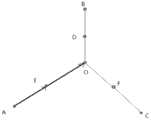
确定第一道路的结束坐标和N个道路的起始坐标相邻的扫描区域,将所述扫描区域按照预定面积划分为若干子区域,即取所述第一道路与N个道路连接的扫描区域,如设置多个道路连接处的10m*10m面积或更小面积为扫描区域。参见图4,在该图中点O为电子地图中道路口中心点,向正北、正东、正南、正西各扩充5m,建立10m*10m的正方形扫描区域。这里所述N为大于2的整数。Determine the scanning area adjacent to the end coordinates of the first road and the starting coordinates of the N roads, and divide the scanning area into several sub-areas according to a predetermined area, that is, take the scanning area connecting the first road and the N roads , such as setting the area of 10m*10m or less at the connection of multiple roads as the scanning area. Referring to Figure 4, in this figure, point O is the center point of the road intersection in the electronic map, and it expands 5m to the due north, due east, due south and due west to establish a square scanning area of 10m*10m. Here, N is an integer greater than 2.
将在所述扫描区域内的行驶轨迹叠加,截取在扫描区域内的轨迹为轨迹段。在图4中T1(AB)、T2(CD)、T3(EF)为截取的轨迹段。之后确定行驶轨迹点的核心坐标区域,将所述行驶轨迹按照所述核心行驶中心坐标调整,根据调整后的行驶轨迹与所述第一道路和N个道路坐标进行匹配。The driving trajectories in the scanning area are superimposed, and the trajectories in the scanning area are intercepted as trajectory segments. In FIG. 4 , T1 (AB), T2 (CD), and T3 (EF) are the intercepted track segments. Then, the core coordinate area of the driving trajectory point is determined, the driving trajectory is adjusted according to the core driving center coordinates, and the adjusted driving trajectory is matched with the first road and N road coordinates.
可选的,将扫描区域按边均分成若干子区域,例如可将扫描区域划分为若干个1m*1m的子区域,每个子区域左下角点的索引设定为[0][0],记扫描区域内某个子区域左下角点距扫描区域左下角点的横向距离为dx米,纵向距离为dy米,则该子区域左下角点的索引为[dx][dy](如图4中深色子区域左下角点的索引即为[2][4],中心浅色子区域左下角点的索引即为[2][2]),以某个子区域的左下角分别向右,向上扩充2m,可建立2m*2m的方形子区域,方形子区域我们用三元组(dx,dy,2)表示(图4示意图深色的方形子区域记为(2,4,2),中心浅色的方形子区域记为(2,2,2))。之后,遍历扫描区域中所有非接边的方形子区域。参见图5,该图展示了以6m*6m的扫描区域为例,对9个方形区域的遍历过程。这里为了便于解释本发明,可以称这个轨迹交叉处的区域为“特征点扩充域”。Optionally, divide the scanning area into several sub-areas according to the sides. For example, the scanning area can be divided into several 1m*1m sub-areas, and the index of the lower left corner of each sub-area is set to [0][0]. The horizontal distance from the lower left corner of a sub-area in the scanning area to the lower left corner of the scanning area is dx meters, and the vertical distance is dy meters, then the index of the lower left corner of the sub-area is [dx][dy] (as shown in Figure 4 deep The index of the lower left corner of the color sub-region is [2][4], and the index of the lower left corner of the central light-colored sub-region is [2][2]). The lower left corner of a certain sub-region expands to the right and upward respectively. 2m, a square sub-area of 2m*2m can be established. The square sub-area is represented by a triple (dx, dy, 2). The colored square sub-region is denoted as (2,2,2)). After that, traverse all non-contact square sub-areas in the scan area. Referring to FIG. 5 , the figure shows the traversal process of 9 square areas by taking a scanning area of 6m*6m as an example. Here, for the convenience of explaining the present invention, the region at the intersection of the trajectories may be referred to as the "feature point extension domain".
每个“特征点扩充域”还可以根据其中所包括的轨迹点数量的多少,将其状态可标记为“待识别”、“已识别”、“已匹配”。在初始化状态下,所有方形子区域的状态均为“待识别”。Each "feature point extension domain" can also be marked as "to be recognized", "recognized", and "matched" according to the number of trajectory points included in it. In the initialization state, the state of all square sub-regions is "to be recognized".
在扫描区域的每个方形子区域都有可能对应一个轨迹交叉处邻近点的集中区域。若某个“特征点扩充域”的边缘与扫描区域内全部轨迹段的交点数大于2小于等于8,则认为行驶轨迹高概率经过当前子区域,将子区域作为核心坐标区域,并将该扩充域标记为“已识别”。Each square sub-area in the scanning area may correspond to a concentrated area of adjacent points at the intersection of the tracks. If the number of intersections between the edge of a certain "feature point extension domain" and all the trajectory segments in the scanning area is greater than 2 and less than or equal to 8, it is considered that the driving trajectory has a high probability of passing through the current sub-area, and the sub-area is regarded as the core coordinate area, and the extension Domains are marked as "Identified".
图4中的中间浅色子区域与全部轨迹段T1,T2,T3的交点数为6,正下方浅色子区域与T2,T3的交点数为4,正上方深色子区域与T1,T3的交点数为4,则将子区域作为核心坐标区域,并标记为“已识别”区域。In Figure 4, the number of intersections between the middle light-colored sub-region and all track segments T1, T2, and T3 is 6; If the number of intersections is 4, the sub-region is taken as the core coordinate region and marked as the "Identified" region.
其余白色方形子区域与全部轨迹段T1,T2的交点数均小于等于2,则仍为“待识别”区域。The number of intersections between the remaining white square sub-regions and all the track segments T1 and T2 is less than or equal to 2, and they are still "to be identified" regions.
交点数大于8的情况过于复杂,即使用“特征点”也不能确定匹配,统一留到后面的线匹配,再挂接。The situation where the number of intersection points is greater than 8 is too complicated, even if the "feature point" is used, the matching cannot be determined, and the matching is left to the following lines, and then connected.
逐一遍历“已识别”的特征点扩充域。截取“已识别”的“特征点扩充域”边缘和扫描区域边缘之间的轨迹段T1…Tn,计算路串的端点坐标(第一道路或路串和其它N个道路或路串的端点坐标都相同)到扫描区域边缘交点的方位角:L1(OA),L2(OB),L3(OC),L4(OD)。计算每段轨迹段从特征点扩充域边缘交点到扫描区域边缘交点的方位角:T1(EF),T2(GH),T3(IJ),T4(MN),T5(PQ),T6(RS)。Traverse the "identified" feature point augmentation domain one by one. Intercept the trajectory segment T1...Tn between the edge of the "recognized" "feature point extension domain" and the edge of the scanning area, and calculate the endpoint coordinates of the road string (the endpoint coordinates of the first road or road string and the other N roads or road strings All the same) azimuth angles to the intersection of the edges of the scan area: L1(OA), L2(OB), L3(OC), L4(OD). Calculate the azimuth angle of each trajectory segment from the edge intersection of the feature point extension domain to the edge intersection of the scanning area: T1(EF), T2(GH), T3(IJ), T4(MN), T5(PQ), T6(RS) .
方位角的概念说明:以正北方向为0°,顺时针递增,值域为[0°,360°),方位角(Azimuth)在下文用其英文简写Az表示。参见图7,该图为方位角的示意图。Concept description of azimuth angle: take the true north direction as 0°, increase clockwise, the value range is [0°, 360°), and the azimuth angle (Azimuth) is represented by its English abbreviation Az in the following. See FIG. 7 , which is a schematic diagram of an azimuth angle.
如图6中,L1方位角:Az(L1)=0°,Az(L2)=90°,Az(L3)=180°,Az(L4)=270°。As shown in FIG. 6, the L1 azimuth angle: Az(L1)=0°, Az(L2)=90°, Az(L3)=180°, Az(L4)=270°.
T1,T2的方位角:Az(T1)=Az(T2)=0°,T3的方位角:Az(T3)=90°,T4的方位角大致为185°,T5的方位角大致为180°,T6的方位角大致为270°。The azimuth angle of T1 and T2: Az(T1)=Az(T2)=0°, the azimuth angle of T3: Az(T3)=90°, the azimuth angle of T4 is approximately 185°, and the azimuth angle of T5 is approximately 180° , the azimuth of T6 is roughly 270°.
为了能够清楚的介绍本发明的技术方案,这里还需要进一步对两轨迹段T1,T2最大投影距离的概念进行说明,点到折线段的投影距离参见图8。In order to clearly introduce the technical solution of the present invention, the concept of the maximum projection distance of the two trajectory segments T1 and T2 needs to be further explained here. The projection distance from the point to the polyline segment is shown in FIG. 8 .
根据平面直角坐标系求解点到直线段的垂足点,如果垂足点在直线段上,则垂足点即为点到直线段的投影点;如果垂足点在直线段的起点外侧,则直线段的起点为点到直线段的投影点;如果垂足点在直线段终点的外侧,则直线段的终点即为点到直线段的投影点。求出点到折线上所有直线段的投影点的距离,其中最小的距离值为点到折线段的投影距离。According to the plane rectangular coordinate system, the vertical foot point from the point to the straight line segment is solved. If the vertical foot point is on the straight line segment, the vertical foot point is the projection point of the point to the straight line segment; if the vertical foot point is outside the starting point of the straight line segment, then The starting point of the line segment is the projection point of the point to the line segment; if the vertical foot point is outside the end point of the line segment, the end point of the line segment is the projection point of the point to the line segment. Find the distance from the point to the projected point of all line segments on the polyline, where the smallest distance is the projected distance from the point to the polyline segment.
参见图9,该图为两轨迹段T1,T2的最大投影距离的示意图:Referring to Figure 9, the figure is a schematic diagram of the maximum projection distance of the two trajectory segments T1, T2:
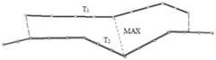
计算轨迹段T1上所有形状点(坐标)到轨迹段T2(坐标)的距离,再计算轨迹段T2上所有形状点到轨迹段T1的距离,所有距离中的最大值为轨迹段T1,T2的最大投影距离,两轨迹段T1,T2的最大投影距离(Maximum Projection Distance)在下文中用其英文简写MPD(T1,T2)表示。Calculate the distance from all shape points (coordinates) on the trajectory segment T1 to the trajectory segment T2 (coordinates), and then calculate the distance from all the shape points on the trajectory segment T2 to the trajectory segment T1, the maximum value of all the distances is the trajectory segment T1, T2 The maximum projection distance, the maximum projection distance (Maximum Projection Distance) of the two trajectory segments T1, T2, is hereinafter represented by its English abbreviation MPD(T1, T2).
统计“特征点扩充域”边缘和扫描区域边缘之间“等价轨迹段类”的数量,计算每个“等价轨迹段类”的平均方位角Az(C)。参见图10,该图为合并“等价轨迹段类”示意图。下以图10为例,进行说明:Count the number of "equivalent trajectory segment classes" between the edge of the "feature point extension domain" and the edge of the scanning area, and calculate the average azimuth angle Az(C) of each "equivalent trajectory segment class". Referring to Fig. 10, the figure is a schematic diagram of merging "equivalent trajectory segment classes". Take Figure 10 as an example to illustrate:
1、初始化每条轨迹段T1,T2…,T6为一个“等价轨迹段类”C1,C2,…,C61. Initialize each trajectory segment T1, T2..., T6 as an "equivalent trajectory segment class" C1, C2,..., C6
2、对C1,C2,…,C6两两进行比较,若对C1,C2中的任两条轨迹段,都满足方位角之差:ABS(Az(T1)-Az(T2))<10°,且最大投影距离MPD(T1,T2)<1.5m,则合并C1,C2为一个“等价轨迹段类”。2. Comparing C1, C2,..., C6 pairwise, if any two trajectory segments in C1 and C2 satisfy the difference in azimuth angle: ABS(Az(T1)-Az(T2))<10° , and the maximum projection distance MPD(T1, T2)<1.5m, then merge C1 and C2 into an "equivalent trajectory segment class".
3、迭代执行(2)步骤,直到所有“等价轨迹段类”两两进行比较,没有发生合并操作,则迭代终止。3. Step (2) is performed iteratively until all "equivalent trajectory segment classes" are compared pairwise, and no merge operation occurs, then the iteration is terminated.
图10中会合并为4个“等价轨迹段类”:C1{T1,T2},C3{T3},C4{T4,T5},C6{T6}.Figure 10 will be merged into 4 "equivalent trajectory segment classes": C1{T1,T2}, C3{T3}, C4{T4,T5}, C6{T6}.
平均方位角:Az(C1)=0°,Az(C3)=90°,Az(C4)=182.5°,Az(C6)=270°Average azimuth: Az(C1)=0°, Az(C3)=90°, Az(C4)=182.5°, Az(C6)=270°
若合并后“等价轨迹段类”的数量和道路特征点挂接的道路数不相等:则跳过对当前特征点扩充域的处理,对下一个“已识别”的特征点扩充域进行上述有关计算每条路串从多道路挂接点到扫描区域边缘交点的方位角的操作,及计算每个“等价轨迹段类”的平均方位角Az(C)并进行相应合并的操作。If the number of “equivalent trajectory segment classes” after merging is not equal to the number of roads connected to road feature points: skip the processing of the current feature point extension domain, and perform the above-mentioned process on the next “identified” feature point extension domain The operation of calculating the azimuth angle of each road string from the multi-road attachment point to the scanning area edge intersection, and the operation of calculating the average azimuth angle Az(C) of each "equivalent track segment class" and combining them accordingly.
若合并后“等价轨迹段类”的数量和道路特征点挂接的道路数相等:检测挂接的每条道路Li是否都对应存在一个“等价轨迹段类”Cm,满足方位角之差的绝对值:If the number of “equivalent trajectory segment classes” after merging is equal to the number of roads connected by road feature points: check whether each connected road Li corresponds to an “equivalent trajectory segment class” Cm, which satisfies the difference in azimuth angle. The absolute value of :
ABS(Az(Li)–Az(Cm))<10°ABS(Az(Li)–Az(Cm))<10°
若任一条道路Li找不到对应:则跳过当前特征点扩充域,对下一个“已识别”的特征点扩充域进行上述有关计算每条路串从多道路挂接点到扫描区域边缘交点的方位角的操作,及计算每个“等价轨迹段类”的平均方位角Az(C)并进行相应合并的操作。If any road Li can’t find the corresponding: skip the current feature point expansion domain, and perform the above-mentioned calculation on the next “identified” feature point expansion domain for each road string from the multi-road attachment point to the edge intersection of the scanning area. The operation of the azimuth angle, and the operation of calculating the average azimuth angle Az(C) of each "equivalent trajectory segment class" and performing the corresponding merge operation.
若全部道路都能够找到对应的“等价轨迹段类”:则将当前“特征点扩充域”标记为“已匹配”,计算道路Li与其对应的“等价轨迹段类”中每条轨迹段Tm的差异值:If all roads can find the corresponding "equivalent trajectory segment class": mark the current "feature point extension domain" as "matched", and calculate each trajectory segment in the road Li and its corresponding "equivalent trajectory segment class" Difference in Tm:
Diff(Li,Tm)=α*ABS(Az(Li)–Az(Tm))+(1-α)*MPD(Li,Tm)Diff(Li,Tm)=α*ABS(Az(Li)–Az(Tm))+(1-α)*MPD(Li,Tm)
其中α为加权值,默认取0.8。where α is the weighted value, which is 0.8 by default.
如图10中道路L3和“等价轨迹段类”C4满足方位角之差的绝对值<10°,计算As shown in Figure 10, road L3 and "equivalent trajectory segment class" C4 satisfy the absolute value of the difference in azimuth angle <10°, calculate
Diff(L3,T4)=0.8×2.5+0.2×0.6=2.12,Diff(L3,T5)=0.8×0+0.2×0.4=0.08Diff(L3,T4)=0.8×2.5+0.2×0.6=2.12, Diff(L3,T5)=0.8×0+0.2×0.4=0.08
则道路L3与C4中差异度最低的轨迹段T5即为匹配。Then, the track segment T5 with the lowest degree of difference between the roads L3 and C4 is matched.
同理可得,道路L1与轨迹段T1,道路L2与轨迹段T3,道路L4与轨迹段T6匹配。Similarly, the road L1 matches the track segment T1, the road L2 matches the track segment T3, and the road L4 matches the track segment T6.
道路L1,L2,L3,L4和轨迹段T1,T3,T5,T6的状态标记为“匹配”。The states of roads L1, L2, L3, L4 and trajectory segments T1, T3, T5, T6 are marked as "matched".
通过“已匹配”的特征点扩充域边缘与各标记为“匹配”轨迹段(T1,T3,T5,T6)的交点(E,I,P,R),求出几个交点的平均X,Y坐标A(X,Y),A点可视为道路或路串的端点O的匹配点,为核心行驶中心坐标。参见图11,该图为计算特征点匹配点的示意图。Through the "matched" feature point extension domain edge and the intersections (E, I, P, R) of each marked "matched" trajectory segment (T1, T3, T5, T6), find the average X of several intersections, Y coordinate A (X, Y), point A can be regarded as the matching point of the endpoint O of the road or road string, and is the core driving center coordinate. Refer to FIG. 11 , which is a schematic diagram of calculating feature point matching points.
根据所述核心子区域内的行驶轨迹计算核心行驶中心坐标,将所述扫描区域内的行驶轨迹按照所述核心行驶中心坐标进行调整。即将所有轨迹在特征点扩充域中的形状点统一替换为特征点的匹配点,并调整轨迹上形状点的序号。参见图12。The core driving center coordinates are calculated according to the driving trajectory in the core sub-area, and the driving trajectory in the scanning area is adjusted according to the core driving center coordinates. That is, the shape points of all trajectories in the feature point extension domain are uniformly replaced with the matching points of the feature points, and the sequence number of the shape points on the trajectory is adjusted. See Figure 12.
如图12,T1,T2,T3三条轨迹所有在特征点扩充域中的形状点统一由核心行驶中心坐标A点替代,同时特征点扩充域外,轨迹的形状点序号也会进行调整。As shown in Figure 12, all the shape points of the three trajectories T1, T2, and T3 in the feature point expansion domain are uniformly replaced by the core driving center coordinate point A. At the same time, outside the feature point expansion domain, the shape point number of the trajectory will also be adjusted.
例如:T1轨迹采集时由B通向C,调整前,B的形状点序号:SEQ(T1,B)=388,C的形状点序号SEQ(T1,C)=392;调整后,SEQ(T1,B)=388,SEQ(T1,A)=389,SEQ(T1,C)=390。For example: when the T1 track is collected, B leads to C. Before adjustment, the shape point number of B: SEQ(T1,B)=388, and the shape point number of C is SEQ(T1,C)=392; after adjustment, SEQ(T1 , B)=388, SEQ(T1,A)=389, SEQ(T1,C)=390.
T3轨迹采集时由D通向E,调整前,SEQ(T3,D)=161,SEQ(T3,E)=164;调整后,SEQ(T3,D)=161,SEQ(T3,A)=162,SEQ(T3,E)=163。During T3 track acquisition, D leads to E. Before adjustment, SEQ(T3,D)=161, SEQ(T3,E)=164; after adjustment, SEQ(T3,D)=161, SEQ(T3,A)= 162, SEQ(T3,E)=163.
至此确定了道路L1,L2,L3,L4所匹配的轨迹段和端点O在轨迹上匹配A点的序号。So far, it is determined that the track segments matched by the roads L1, L2, L3, and L4 and the endpoint O match the sequence number of point A on the track.
采用如下四元组方式记录:Record in the following quadruple format:
<L1,O,T3,SEQ(T3,A)>,<L2,O,T2,SEQ(T2,A)>,<L1, O, T3, SEQ(T3, A)>, <L2, O, T2, SEQ(T2, A)>,
<L3,O,T3,SEQ(T3,A)>,<L4,O,T1,SEQ(T1,A)><L3, O, T3, SEQ(T3, A)>, <L4, O, T1, SEQ(T1, A)>
第一个四元组表示路串L1的端点O与轨迹T3的第162个点匹配。The first quadruple indicates that the endpoint O of the road string L1 matches the 162nd point of the trajectory T3.
至此,当前道路或路串中所涉及到的行驶轨迹匹配操作完成,行驶轨迹按照计算得到的A进行了相应的调整。So far, the matching operation of the driving trajectory involved in the current road or road string is completed, and the driving trajectory is adjusted accordingly according to the calculated A.
同理,对每个多道路连接的岔路口节点执行上述匹配操作,使每个道路或路串的端点都完成与行驶轨迹的匹配,进一步包括:获取道路的两端端点坐标之间的道路形状和距离,以及对应的行驶轨迹上两个核心行驶中心坐标之间的轨迹形状和距离,判断若两个核心行驶中心属于同一行驶轨迹,且道路和行驶轨迹段的长度比不超过预置的阈值,将道路和行驶轨迹进行匹配。In the same way, the above matching operation is performed on each fork node connected by multiple roads, so that the end points of each road or road string are matched with the driving trajectory, and further includes: obtaining the road shape between the coordinates of the end points of the two ends of the road. and distance, as well as the trajectory shape and distance between the coordinates of the two core driving centers on the corresponding driving trajectory, determine if the two core driving centers belong to the same driving trajectory, and the length ratio of the road and the driving trajectory segment does not exceed the preset threshold , to match the road and the driving trajectory.
如果某条路串Li的两端A点,B分别匹配轨迹Ti上序号SEQ1,SEQ2的点(如T1上的C,D,两个点匹配的四元组结果为<L1,A,T1,SEQ(T1,C)>,<L1,B,T1,SEQ(T1,D)>),且路串的长度与轨迹长度(因为行驶轨迹点间距约1m,轨迹长度可用SEQ1-SEQ2近似)大致相同,即满足:If points A and B at both ends of a road string Li match the points of sequence numbers SEQ1 and SEQ2 on the trajectory Ti respectively (such as C, D on T1, the result of the quadruple matching the two points is < L1, A, T1, SEQ(T1,C)>, <L1,B, T1, SEQ(T1,D)>), and the length of the road string and the track length (because the distance between the driving track points is about 1m, the track length can be approximated by SEQ1-SEQ2) same, i.e. satisfying:
ABS(Length(Li)-ABS(SEQ1-SEQ2))/Length(Li)<0.1ABS(Length(Li)-ABS(SEQ1-SEQ2))/Length(Li)<0.1
则匹配成功,将T1的[SEQ1,SEQ2]作为L1的匹配轨迹段,记录匹配结果。参见图13,该图为检测端点匹配到相同轨迹的示意图。Then the matching is successful, and [SEQ1, SEQ2] of T1 is used as the matching track segment of L1, and the matching result is recorded. Referring to FIG. 13 , the figure is a schematic diagram of detecting endpoints matching to the same trajectory.
如果路串Li的端A点和B分别匹配同一条轨迹Ti上序号为SEQ1,SEQ2的点,却有:If the end points A and B of the road string Li respectively match the points with the serial numbers of SEQ1 and SEQ2 on the same trajectory Ti, there are:
ABS(Length(Li)-ABS(SEQ1-SEQ2))/Length(Li)>=0.1ABS(Length(Li)-ABS(SEQ1-SEQ2))/Length(Li)>=0.1
则路串Li匹配失败,留到线匹配处理。Then the matching of the road string Li fails, and it is left to the line matching processing.
如果路串两端匹配到不同的轨迹段,如图13中A端点与轨迹T1的C点匹配,B端点与轨迹T2的D点匹配则该路串匹配失败,即两个点匹配的四元组结果为:If the two ends of the road string match to different trajectory segments, as shown in Figure 13, the A endpoint matches the C point of the trajectory T1, and the B endpoint matches the D point of the trajectory T2, then the matching of the road string fails, that is, the quaternion of the two points matching The group result is:
<L1,A,T1,SEQ(T1,C)>,<L1,B,T2,SEQ(T2,D)>),则路串Li匹配失败,留到线匹配处理。<L1, A, T1, SEQ(T1,C)>, <L1, B, T2, SEQ(T2,D)>), then the matching of the string Li fails, and it is left to the line matching processing.
如果路串Li只有一端A匹配到轨迹上T1的C,另一端点B没有成功的匹配结果,则通过B的坐标找轨迹T1上距离其最近的形状点D,设C的形状点序号为SEQ1,D的形状点序号为SEQ2。h为点D距点B的距离阈值,可设定为5—10m之间。If only one end A of the road string Li matches the C of T1 on the trajectory, and the other end B has no successful matching result, then find the nearest shape point D on the trajectory T1 through the coordinates of B, and set the shape point number of C to SEQ1 , the shape point sequence number of D is SEQ2. h is the distance threshold between point D and point B, which can be set between 5-10m.
若同时满足:If both:
Distance(B,D)<h,且ABS(Length(Li)-ABS(SEQ1-SEQ2))/Length(Li)<0.1Distance(B, D)<h, and ABS(Length(Li)-ABS(SEQ1-SEQ2))/Length(Li)<0.1
则匹配成功,记录匹配结果。否则匹配失败,路串Li留到线匹配处理。参见图14,该图为路串只有一个端点匹配到轨迹的示意图。The matching is successful, and the matching result is recorded. Otherwise, the matching fails, and the path string Li is left to the line matching process. Referring to FIG. 14 , this figure is a schematic diagram of only one end point of the road string matched to the track.
如果某条路串两端都没有匹配到任何轨迹,则该路串匹配失败,留到线匹配处理。If the two ends of a road string do not match any track, the road string matching fails and is left to the line matching process.
经过上述步骤,完成了“基于特征点扩充域”的智能匹配。参见图15,该图为通过使用上述操作对行驶轨迹按照匹配结果进行调整后的效果图。After the above steps, the intelligent matching "based on feature point extension domain" is completed. Referring to FIG. 15 , it is an effect diagram after adjusting the driving trajectory according to the matching result by using the above operation.
通过使用上述方法,使得道路与行驶轨迹的匹配准确性有了较大的提高,同时,有效提升了对“十字交叉口”,“匝道入主路”处等容易出现“道路挂接,轨迹未挂接”情况的处理准确率。By using the above method, the matching accuracy between the road and the driving trajectory has been greatly improved. The handling accuracy of the "Hook" case.
在进行上述操作后,可以将正常路串上的轨迹和多道路连接的岔路口行驶轨迹进行了相应的匹配。但由于实际交通道路的复杂性及客观存在的若干可能影响到匹配准确性的因素,造成仍然存在一定量的道路无法与获得的行驶轨迹进行匹配。After the above operations are performed, the trajectories on the normal road string and the driving trajectories of the fork roads connected by multiple roads can be matched accordingly. However, due to the complexity of actual traffic roads and some objective factors that may affect the matching accuracy, there are still a certain amount of roads that cannot be matched with the obtained driving trajectories.
因此,在本发明提供的一种行驶轨迹与路网底图的智能匹配方法的第二实施例中,还包括一种具有补充作用的“线匹配”方法,用来针对上述操作未能够正常匹配的道路和行驶轨迹的匹配,进一步补充和完善技术方案:Therefore, in the second embodiment of the intelligent matching method between the driving trajectory and the road network base map provided by the present invention, it also includes a supplementary "line matching" method, which is used for the above-mentioned operations that cannot be properly matched The matching of roads and driving trajectories further supplements and improves technical solutions:
若行驶轨迹在所述路串周围的指定范围内经过,以所述路串为中心设定扩展区域;If the driving track passes within a specified range around the road string, an expansion area is set with the road string as the center;
将长度相似比和形状相似比满足预置阈值且处于所述路串的扩展区域内的行驶轨迹,作为与所述路串相匹配的行驶轨迹。The travel trajectories whose length similarity ratio and shape similarity ratio satisfy the preset threshold and are located in the expansion area of the road string are taken as the traveling trajectories matching the road string.
可选的,根据路串的坐标信息建立缓冲区。其中,如果针对坐标点,则缓冲区的范围是半径为预置缓冲值的圆形区域;如果针对由若干个点组成的路串坐标,则缓冲区的范围可以是与折线形状一致的带形区域,宽度为预置缓冲值的2倍,起点和终点位置向外延伸为半径为预置缓冲值的半圆。参见图16,该图为道路缓冲区示意图。Optionally, a buffer is established according to the coordinate information of the road string. Among them, if it is for coordinate points, the scope of the buffer zone is a circular area with a radius of a preset buffer value; if it is for the coordinates of a road string composed of several points, the scope of the buffer zone can be a strip shape consistent with the shape of a polyline Area, the width is 2 times of the preset buffer value, and the start and end positions extend outward as a semicircle with a radius of the preset buffer value. Referring to Figure 16, the figure is a schematic diagram of a road buffer zone.
在一般情况下,“路串周围的指定范围内”可以是在道路的周围为0-8米范围之内的区域,优选的距离为5米内。In general, "within a specified range around the road string" may be an area within a range of 0-8 meters around the road, and a preferred distance is within 5 meters.
查询并截取与路串建立的缓冲区有空间关系的轨迹段。为了查询到尽可能多的轨迹段,这里的“空间关系”包括轨迹段与缓冲区域相交、相切、完全落入。参见图17,该图为行驶轨迹(Link)落入缓冲区(Linkbuffer)的示意图。Query and intercept the track segments that have a spatial relationship with the buffer created by the road string. In order to query as many trajectory segments as possible, the "spatial relationship" here includes the intersection, tangent, and complete fall of the trajectory segment and the buffer area. Referring to FIG. 17 , this figure is a schematic diagram of the travel track (Link) falling into the buffer area (Linkbuffer).
之后,根据长度相似比和形状相似比筛选出满足阈值条件的轨迹段,加权选择最可能匹配的轨迹段进行匹配。Then, according to the length similarity ratio and the shape similarity ratio, the trajectory segments that meet the threshold conditions are screened out, and the most likely matching trajectory segments are selected by weighting for matching.
这里,计算长度相似比和形状相似比的公式如下:Here, the formulas for calculating the length similarity ratio and the shape similarity ratio are as follows:
长度相似比:R(l)=DISTANCE(行驶轨迹在缓冲区内部分的长度)/DISTANCE(路串的长度)。Length similarity ratio: R(l)=DISTANCE (the length of the travel track in the buffer zone)/DISTANCE (the length of the road string).
形状相似比:R(s)=1-ABS(DISTANCE(行驶轨迹在缓冲区内部分的长度)-DISTANCE(路串投影))/DISTANCE(行驶轨迹在缓冲区内部分的长度)。Shape similarity ratio: R(s)=1-ABS(DISTANCE (the length of the part of the driving track in the buffer)-DISTANCE (the road string projection))/DISTANCE (the length of the part of the driving track in the buffer).
在形状相似比的公式中包含DISTANCE(路串投影),这里对路串投影的映射规则进行具体说明:The DISTANCE (road string projection) is included in the formula of the shape similarity ratio. Here, the mapping rules of the road string projection are described in detail:
参考线A到基准线B的平面投影计算:Plane projection calculation of reference line A to reference line B:
1)分别求出线A的起点和终点到线B的投影点;1) Find the projection points of the start and end points of line A to line B respectively;
2)线B上两个投影点(图中虚线部分)以及投影点中间的形状点的连线即为线A到线B的投影线。参见图18,该图为路串投影的示意图。2) The line connecting the two projection points on line B (the dotted line part in the figure) and the shape point in the middle of the projection points is the projection line from line A to line B. Referring to FIG. 18 , the figure is a schematic diagram of road string projection.
分别设定长度相似度和形状相似度的选择阈值为H(l)和H(s),长度相似度和形状相似度的加权值分别为α和1-α(α默认值0.5)。The selection thresholds of length similarity and shape similarity are set as H(l) and H(s), respectively, and the weighted values of length similarity and shape similarity are α and 1-α (default value of α is 0.5).
在计算某路串的匹配轨迹段时,首先筛选出满足阈值条件的轨迹段,再对筛选后的每条轨迹段计算:R=α*R(l)+(1-α)*R(s),R值最高的轨迹段即为路串的匹配轨迹段。When calculating the matching trajectory segment of a road string, first filter out the trajectory segment that meets the threshold condition, and then calculate for each track segment after screening: R=α*R(l)+(1-α)*R(s ), the trajectory segment with the highest R value is the matching trajectory segment of the road string.
在进行上述操作后,可以扩展道路或路串的坐标区域,从而增加能够匹配的行驶轨迹的可能性和准确性。在实际中,经常出现路串的端点(起始点或结束点)未与匹配的行驶轨迹的端点进行对应或挂接的情况。After the above operations are performed, the coordinate area of the road or road string can be expanded, thereby increasing the possibility and accuracy of the matching driving trajectory. In practice, it often occurs that the endpoints (starting points or ending points) of the road string do not correspond to or are linked with the endpoints of the matching travel track.
因此,在本发明提供的一种行驶轨迹与路网底图的智能匹配方法的第三实施例中,还包括一种方法解决上述问题:Therefore, in the third embodiment of the intelligent matching method between the driving trajectory and the road network base map provided by the present invention, it also includes a method to solve the above problems:
若处于相邻路串上的行驶轨迹的端点坐标不相同,计算所述行驶轨迹间的端点坐标的距离是否小于预置端点距离阈值;If the endpoint coordinates of the travel tracks on adjacent road strings are not the same, calculate whether the distance between the endpoint coordinates of the travel tracks is less than a preset endpoint distance threshold;
若小于,则根据各行驶轨迹的端点坐标计算中心端点坐标,分别作为相邻路串上的行驶轨迹的新端点坐标。If it is smaller than that, calculate the center endpoint coordinates according to the endpoint coordinates of each driving track, and use them as the new endpoint coordinates of the driving tracks on the adjacent road strings respectively.
若行驶轨迹间的端点坐标的距离大于预置端点距离阈值,则不必执行上述计算中心端点坐标的操作。If the distance between the endpoint coordinates between the travel trajectories is greater than the preset endpoint distance threshold, it is not necessary to perform the above operation of calculating the center endpoint coordinates.
具体处理步骤为:The specific processing steps are:
1)找到需要处理的轨迹段T1,…,Tn和其待挂接的端点N1,…,Nn。1) Find the track segments T1,...,Tn to be processed and their endpoints N1,...,Nn to be attached.
2)计算N1,…,Nn中每两端点间的距离,设定距离阈值为H(d),若存在Distance(Ni,Nj)>H(d),则这组端点处程序不自动挂接,以“道路点,<轨迹段Ti,待挂接轨迹点序号SEQ>”的LOG形式输出给用户。2) Calculate the distance between each end point in N1,...,Nn, set the distance threshold as H(d), if there is Distance(Ni,Nj)>H(d), the program at this group of end points is not automatically linked , and output to the user in the form of LOG in the form of "road point, <track segment Ti, sequence number of track point to be attached SEQ>".
3)若全部点间距均小于H(d),则取所有端点的平均(X,Y)坐标(即所有端点连线多边形的几何重心),新建一个挂接点O(X,Y),对应轨迹段的对应端添加O点为新端点。参见图19,该图为新增轨迹段挂接点示意图。3) If the distance between all points is less than H(d), then take the average (X, Y) coordinates of all endpoints (that is, the geometric center of gravity of the polygon connecting all endpoints), and create a new attachment point O(X, Y), corresponding to the trajectory The corresponding end of the segment adds an O point as a new end point. Referring to FIG. 19 , this figure is a schematic diagram of a newly added track segment attachment point.
至此,通过使用以上介绍的几种方法及其组合,可以较为精准而全面地完成了道路路段与实采行驶轨迹“线与端点“的一一匹配,可以实现根据与所述路网底图路串相匹配的行驶轨迹数据对已有路网底图的数据的更新。So far, by using the above-mentioned methods and their combinations, one-to-one matching between the road sections and the actual driving trajectories "lines and endpoints" can be completed accurately and comprehensively, and the road network base map can be achieved according to the road network base map. The data of the existing road network base map is updated by the matching driving trajectory data.
以上为本发明提供的一种行驶轨迹与路网底图的智能匹配的方法,基于其原理,本发明还提供整片行驶轨迹与路网底图的智能匹配装置,具体如下:The above is a method for intelligently matching the driving track and the road network base map provided by the present invention. Based on its principle, the present invention also provides an intelligent matching device for the entire driving track and the road network base map, as follows:
参见图20,该图为本发明提供的一种行驶轨迹与路网底图的智能匹配装置的第一实施例和第二实施例串行实施的原理框图。Referring to FIG. 20 , this figure is a schematic block diagram of the serial implementation of the first embodiment and the second embodiment of an intelligent matching device for a driving trajectory and a road network base map provided by the present invention.
在第一实施例中,包括:匹配数据获取模块10、路串构建模块20和路口点匹配模块30。其中:In the first embodiment, it includes: a matching
匹配数据获取模块10,用于分别获取路网底图中道路的坐标和行驶轨迹的数据;The matching
路串构建模块20,用于根据所述路网底图中道路属性,判断出某一道路的两端只存在一条可通行道路,则将其串接为路串;The road
路口点匹配模块30,用于判断出若所述路网底图中某一道路的结束点与两条以上的道路通行,则以所述某一道路的结束点与两条以上的道路连接区域构建特征点扩充区域;识别所述特征点扩充区域内的所述行驶轨迹,并确定所述行驶轨迹的核心坐标区域及所述核心坐标区域的中心点;根据所述中心点对所述特征点扩充区域内的行驶轨迹进行调整,并与所述路网底图中的相应道路进行匹配。The intersection
作为一种可选的实施方式,所述路串构建模块进一步包括:As an optional embodiment, the road string building module further includes:
路串道路判断子模块,用于判断所述路网底图中第一道路的结束坐标与第二道路的起始坐标是否相同,若相同且第一道路的结束坐标只与第二道路的起始坐标值相同,将所述第一道路和第二道路作为路串;The road string road judgment sub-module is used to judge whether the end coordinates of the first road and the start coordinates of the second road in the road network base map are the same, if they are the same and the end coordinates of the first road are only the same as the start coordinates of the second road. The initial coordinate values are the same, and the first road and the second road are used as road strings;
路串轨迹匹配子模块,用于获取所述路串上经过的行驶轨迹,并将所述经过的行驶轨迹与所述路串进行匹配。A road string track matching sub-module is used to obtain the travel track passed on the road string, and match the passed travel track with the road string.
作为一种可选的实施方式,所述路口点匹配模块进一步包括:As an optional implementation manner, the intersection point matching module further includes:
子区域划分子模块,用于判断第一道路的结束坐标与N个道路的起始坐标是否相同,若相同,则确定第一道路的结束坐标和N个道路的起始坐标相邻的扫描区域,将所述扫描区域按照预定面积划分为若干子区域;The sub-area division sub-module is used to judge whether the end coordinates of the first road and the start coordinates of the N roads are the same, and if they are the same, determine the scanning area adjacent to the end coordinates of the first road and the start coordinates of the N roads , dividing the scanning area into several sub-areas according to a predetermined area;
核心区域标识子模块,用于将经过所述扫描区域的行驶轨迹进行叠加,确定行驶轨迹高概率经过的子区域,作为核心坐标区域;The core area identification sub-module is used to superimpose the driving trajectories passing through the scanning area, and determine the sub-areas that the driving trajectories pass through with high probability, as the core coordinate area;
行驶轨迹调整子模块,用于根据所述核心子区域内的行驶轨迹计算核心行驶中心坐标,将扫描区域内的行驶轨迹按照所述核心行驶中心坐标进行调整;a driving trajectory adjustment sub-module, configured to calculate the core driving center coordinates according to the driving trajectory in the core sub-area, and adjust the driving trajectory in the scanning area according to the core driving center coordinates;
道路匹配子模块,用于获取路网底图道路的两端端点坐标之间的道路形状和距离、以及相对应的行驶轨迹上两个核心行驶中心坐标之间的轨迹形状和距离,判断路网底图的道路和行驶轨迹属于同一连续轨迹段且道路和行驶轨迹段的长度比不超过预置的阈值,将所述路网底图的道路和行驶轨迹进行匹配;其中,所述N为大于2的整数。The road matching sub-module is used to obtain the road shape and distance between the coordinates of the endpoints at both ends of the road network base map, as well as the trajectory shape and distance between the coordinates of the two core driving centers on the corresponding driving trajectory, and determine the road network. The road and driving track of the base map belong to the same continuous track segment and the length ratio of the road and the driving track segment does not exceed a preset threshold, and the road and driving track of the road network base map are matched; wherein, the N is greater than An integer of 2.
作为一种可选的实施方式,所述核心区域标识子模块进一步包括:As an optional implementation manner, the core area identification submodule further includes:
核心区域轨迹定位子模块,用于根据行驶轨迹的坐标确定每个行驶轨迹在所述核心子区域内的行驶轨迹段;a core area trajectory positioning sub-module, configured to determine the driving trajectory segment of each driving trajectory in the core sub-area according to the coordinates of the driving trajectory;
平均方位角计算子模块,用于计算行驶轨迹从所述扫描区域边缘到核心子区域边缘交点的平均方位角;an average azimuth angle calculation sub-module for calculating the average azimuth angle of the driving trajectory from the edge of the scanning area to the intersection of the edge of the core sub-area;
等价轨迹段比较子模块,用于判断若两个行驶轨迹之间的平均方位角之差小于预置方位角阈值,且最大投影距离小于预置投影间隔阈值,将两个行驶轨迹中从所述扫描区域边缘到核心子区域边缘的轨迹段作为同一个等价轨迹段;The equivalent trajectory segment comparison sub-module is used to determine that if the difference between the average azimuth angles between the two driving trajectories is less than the preset azimuth angle threshold, and the maximum projection distance is less than the preset projection interval threshold, the The trajectory segment from the edge of the scanning area to the edge of the core sub-area is regarded as the same equivalent trajectory segment;
中心坐标计算子模块,用于汇总所有的等价轨迹段与所述核心子区域边缘的交点坐标计算核心行驶中心坐标;The center coordinate calculation submodule is used for summarizing the intersection coordinates of all equivalent trajectory segments and the edge of the core subregion to calculate the core driving center coordinates;
中心坐标调整子模块,用于将从所述扫描区域内的行驶轨迹以核心行驶中心坐标为中心进行调整。The center coordinate adjustment sub-module is used to adjust the driving trajectory from the scanning area with the core driving center coordinate as the center.
作为一种可选的实施方式,上述装置还可以包括:As an optional implementation manner, the above-mentioned device may also include:
缓冲区补充匹配模块40,用于判断若行驶轨迹在所述路串周围指定范围内经过,则以所述路串为中心设定扩展区域;将长度相似比和形状相似比满足预置阈值且处于所述路串的扩展区域内的行驶轨迹,作为与所述路串相匹配的行驶轨迹。The buffer
端点平滑调整模块50,用于判断若处于相邻路串上的行驶轨迹的端点坐标不相同,计算并判断所述行驶轨迹间的端点坐标的距离是否小于预置端点距离阈值;在所述行驶轨迹间的端点坐标的距离小于预置端点距离阈值时,则根据各行驶轨迹的端点坐标计算中心端点坐标,分别作为相邻路串上的行驶轨迹的新端点坐标。The endpoint smoothing
作为一种可选的实施方式,上述装置中还可以包括:As an optional implementation manner, the above-mentioned device may also include:
数据更新模块60,用于在所述路网底图中道路与所述行驶轨迹匹配后,根据与所述路网底图数据相匹配的行驶轨迹数据,对所述路网底图的数据进行更新。The
上述装置中的各模块的功能原理可参见前述各方法实施例中的相关说明,这里不再重复进行介绍。For the functional principles of the modules in the foregoing apparatus, reference may be made to the relevant descriptions in the foregoing method embodiments, and the description will not be repeated here.
至此,通过使用以上装置,可以较为精准而全面地完成了道路路段与实采行驶轨迹“线与端点“的一一匹配,实现了实采轨迹对已有路网底图的匹配更新。So far, by using the above devices, one-to-one matching between road sections and actual driving trajectories "lines and endpoints" can be completed accurately and comprehensively, and the matching and updating of the actual mining trajectories to the existing road network basemap is realized.
上述说明示出并描述了本发明的若干可选实施例,但如前所述,应当理解本发明并非局限于本文所披露的形式,不应看作是对其他实施例的排除,而可用于各种其他组合、修改和环境,并能够在本文所述发明构想范围内,通过上述教导或相关领域的技术或知识进行改动。而本领域人员所进行的改动和变化不脱离本发明的精神和范围,则都应在本发明所附权利要求的保护范围内。The foregoing description shows and describes several alternative embodiments of the present invention, but as previously mentioned, it should be understood that the present invention is not limited to the form disclosed herein and should not be construed as an exclusion of other embodiments, but may be used for Various other combinations, modifications and environments, and can be modified within the scope of the inventive concepts described herein, can be modified from the above teachings or skill or knowledge in the relevant fields. However, modifications and changes made by those skilled in the art do not depart from the spirit and scope of the present invention, and should all fall within the protection scope of the appended claims of the present invention.
Claims (11)
Translated fromChinesePriority Applications (1)
| Application Number | Priority Date | Filing Date | Title |
|---|---|---|---|
| CN201610046171.7ACN106996783B (en) | 2016-01-25 | 2016-01-25 | A kind of intelligent matching method and device of driving trajectory and road network base map |
Applications Claiming Priority (1)
| Application Number | Priority Date | Filing Date | Title |
|---|---|---|---|
| CN201610046171.7ACN106996783B (en) | 2016-01-25 | 2016-01-25 | A kind of intelligent matching method and device of driving trajectory and road network base map |
Publications (2)
| Publication Number | Publication Date |
|---|---|
| CN106996783A CN106996783A (en) | 2017-08-01 |
| CN106996783Btrue CN106996783B (en) | 2020-01-31 |
Family
ID=59428956
Family Applications (1)
| Application Number | Title | Priority Date | Filing Date |
|---|---|---|---|
| CN201610046171.7AActiveCN106996783B (en) | 2016-01-25 | 2016-01-25 | A kind of intelligent matching method and device of driving trajectory and road network base map |
Country Status (1)
| Country | Link |
|---|---|
| CN (1) | CN106996783B (en) |
Families Citing this family (16)
| Publication number | Priority date | Publication date | Assignee | Title |
|---|---|---|---|---|
| DE102017216237A1 (en)* | 2017-09-14 | 2019-03-14 | Bayerische Motoren Werke Aktiengesellschaft | Method for determining a course of lanes of a road network and server device for carrying out the method |
| CN108303075B (en)* | 2017-12-29 | 2021-01-29 | 广州斯马特信息科技有限公司 | Track generation method and system |
| CN110948478A (en)* | 2018-09-26 | 2020-04-03 | 上海云绅智能科技有限公司 | Method for controlling activity in designated area and robot |
| CN109916414B (en)* | 2019-03-29 | 2021-07-09 | 百度在线网络技术(北京)有限公司 | Map matching method, apparatus, device and medium |
| CN111811523B (en)* | 2019-04-12 | 2024-04-05 | 北京四维图新科技股份有限公司 | Road network matching error correction method, device and system |
| CN111858620B (en)* | 2019-04-29 | 2024-03-01 | 北京四维图新科技股份有限公司 | Map data updating method and device |
| CN110160539A (en)* | 2019-05-28 | 2019-08-23 | 北京百度网讯科技有限公司 | Map-matching method, calculates equipment and medium at device |
| CN110634291B (en)* | 2019-09-17 | 2020-12-29 | 武汉中海庭数据技术有限公司 | High-precision map topology automatic construction method and system based on crowdsourcing data |
| CN110751751A (en)* | 2019-10-09 | 2020-02-04 | 广州敏视数码科技有限公司 | Driving track recording method |
| CN112857380B (en)* | 2019-11-12 | 2022-12-20 | 北京三快在线科技有限公司 | Method and device for determining road traffic state, storage medium and electronic equipment |
| CN111856521B (en)* | 2019-11-22 | 2023-06-23 | 北京嘀嘀无限科技发展有限公司 | Data processing method, device, electronic equipment and storage medium |
| CN111609860B (en)* | 2020-03-30 | 2022-02-22 | 北京拓明科技有限公司 | Same-track user identification method and device |
| CN111895972B (en)* | 2020-06-11 | 2022-06-17 | 北京四维图新科技股份有限公司 | High-precision map tunnel portal shape generation method, device and medium |
| CN114066088B (en)* | 2021-11-19 | 2025-02-25 | 郑州天迈科技股份有限公司 | A method for binding bus routes and roads based on polar coordinate transformation |
| CN115909286B (en)* | 2023-02-17 | 2023-07-04 | 浙江口碑网络技术有限公司 | Data processing method and device |
| CN116303866B (en)* | 2023-05-18 | 2023-09-22 | 北京明立测绘科技有限公司 | Data processing methods, devices, electronic equipment and storage media |
Citations (6)
| Publication number | Priority date | Publication date | Assignee | Title |
|---|---|---|---|---|
| CN1499399A (en)* | 2002-11-01 | 2004-05-26 | ������������ʽ���� | Map and update instruction information data structure, map information processing and providing device |
| CN102713521A (en)* | 2009-10-22 | 2012-10-03 | 通腾德国股份有限公司 | Incremental map generation, refinement and extension with GPS traces |
| JP5382537B2 (en)* | 2010-02-26 | 2014-01-08 | アイシン・エィ・ダブリュ株式会社 | Navigation device and navigation program |
| CN104240260A (en)* | 2014-10-09 | 2014-12-24 | 武汉大学 | Junction identification based intelligent road extraction method |
| CN104634352A (en)* | 2015-03-02 | 2015-05-20 | 吉林大学 | Road matching method based on fusion of probe vehicle movement track and electronic map |
| CN105021202A (en)* | 2014-04-29 | 2015-11-04 | 高德软件有限公司 | Map matching method and device |
- 2016
- 2016-01-25CNCN201610046171.7Apatent/CN106996783B/enactiveActive
Patent Citations (6)
| Publication number | Priority date | Publication date | Assignee | Title |
|---|---|---|---|---|
| CN1499399A (en)* | 2002-11-01 | 2004-05-26 | ������������ʽ���� | Map and update instruction information data structure, map information processing and providing device |
| CN102713521A (en)* | 2009-10-22 | 2012-10-03 | 通腾德国股份有限公司 | Incremental map generation, refinement and extension with GPS traces |
| JP5382537B2 (en)* | 2010-02-26 | 2014-01-08 | アイシン・エィ・ダブリュ株式会社 | Navigation device and navigation program |
| CN105021202A (en)* | 2014-04-29 | 2015-11-04 | 高德软件有限公司 | Map matching method and device |
| CN104240260A (en)* | 2014-10-09 | 2014-12-24 | 武汉大学 | Junction identification based intelligent road extraction method |
| CN104634352A (en)* | 2015-03-02 | 2015-05-20 | 吉林大学 | Road matching method based on fusion of probe vehicle movement track and electronic map |
Also Published As
| Publication number | Publication date |
|---|---|
| CN106996783A (en) | 2017-08-01 |
Similar Documents
| Publication | Publication Date | Title |
|---|---|---|
| CN106996783B (en) | A kind of intelligent matching method and device of driving trajectory and road network base map | |
| CN102713521B (en) | Generate, refine and augment incremental maps with GPS traces | |
| CN101275841B (en) | Feature information collecting apparatus and feature information collecting method | |
| CN108981741B (en) | Path planning device and method based on high-precision map | |
| US8213682B2 (en) | Feature information collecting apparatuses, methods, and programs | |
| US20060155464A1 (en) | Methods and systems for deducing road geometry and connectivity | |
| CN108830897A (en) | A road centerline extraction method | |
| CN112444254B (en) | Method, apparatus and computer program product for generating correspondence between map versions | |
| JP2019101256A (en) | Traffic lane network data generation device, traffic lane network data generation program, and storage medium | |
| Yang et al. | A pattern‐based approach for matching nodes in heterogeneous urban road networks | |
| KR20190049880A (en) | Systems and methods for displaying locations along a road on a map | |
| US20170211941A1 (en) | Generalising Topographical Map Data | |
| CN110211371A (en) | Method for seeking the topology information of intersection | |
| CN112444255A (en) | Method, device and computer program product for generating correspondence between map versions | |
| CN101644582B (en) | Differential method for navigation electronic map, matching method and device | |
| CN111664856B (en) | Vehicle initial positioning system and vehicle initial positioning method | |
| KR101105808B1 (en) | Pedestrian navigation using a single road system | |
| Zhang et al. | How to model roads in OpenStreetMap? A method for evaluating the fitness-for-use of the network for navigation | |
| CN114705180B (en) | Data correction method, device and equipment for high-precision map and storage medium | |
| CN107588779B (en) | Intelligent vehicle navigation method based on travel time between any two nodes | |
| JP2012122760A (en) | Own-vehicle position recognition system, own-vehicle position recognition program and own-vehicle position recognition method | |
| CN115540885A (en) | Green belt height assignment method and device and storage medium | |
| CN103822637B (en) | The walking facility recognition methods of a kind of disappearance and system | |
| JP5435294B2 (en) | Image processing apparatus and image processing program | |
| JP2020026987A (en) | Traffic light acquisition system, correspondence generating system, and traffic light acquisition program |
Legal Events
| Date | Code | Title | Description |
|---|---|---|---|
| PB01 | Publication | ||
| PB01 | Publication | ||
| SE01 | Entry into force of request for substantive examination | ||
| SE01 | Entry into force of request for substantive examination | ||
| GR01 | Patent grant | ||
| GR01 | Patent grant |