CN106873627B - A multi-rotor unmanned aerial vehicle and method for automatic inspection of transmission lines - Google Patents
A multi-rotor unmanned aerial vehicle and method for automatic inspection of transmission linesDownload PDFInfo
- Publication number
- CN106873627B CN106873627BCN201710208843.4ACN201710208843ACN106873627BCN 106873627 BCN106873627 BCN 106873627BCN 201710208843 ACN201710208843 ACN 201710208843ACN 106873627 BCN106873627 BCN 106873627B
- Authority
- CN
- China
- Prior art keywords
- transmission line
- unit
- drone
- uav
- flight
- Prior art date
- Legal status (The legal status is an assumption and is not a legal conclusion. Google has not performed a legal analysis and makes no representation as to the accuracy of the status listed.)
- Expired - Fee Related
Links
Images

Classifications
- G—PHYSICS
- G05—CONTROLLING; REGULATING
- G05D—SYSTEMS FOR CONTROLLING OR REGULATING NON-ELECTRIC VARIABLES
- G05D1/00—Control of position, course, altitude or attitude of land, water, air or space vehicles, e.g. using automatic pilots
- G05D1/10—Simultaneous control of position or course in three dimensions
- G05D1/101—Simultaneous control of position or course in three dimensions specially adapted for aircraft
Landscapes
- Engineering & Computer Science (AREA)
- Aviation & Aerospace Engineering (AREA)
- Radar, Positioning & Navigation (AREA)
- Remote Sensing (AREA)
- Physics & Mathematics (AREA)
- General Physics & Mathematics (AREA)
- Automation & Control Theory (AREA)
- Control Of Position, Course, Altitude, Or Attitude Of Moving Bodies (AREA)
- Electric Cable Installation (AREA)
Abstract
Description
Translated fromChinese技术领域technical field
本发明涉及无人机输电线路巡检领域,尤其是涉及一种可以自动巡检输电线路的多旋翼无人机及方法。The invention relates to the field of unmanned aerial vehicle transmission line inspection, in particular to a multi-rotor unmanned aerial vehicle capable of automatically inspecting transmission lines and a method.
背景技术Background technique
2020年中国输电线路总长或超159万千米,而输电线路巡检工作是保证安全、可靠供电的重要的、不可缺少的工作。近年来,随着遥控无人机技术的发展,采用无人机巡检电力线路已经具备了技术上的可行性。In 2020, the total length of China's transmission lines may exceed 1.59 million kilometers, and the inspection of transmission lines is an important and indispensable work to ensure safe and reliable power supply. In recent years, with the development of remote control drone technology, it has become technically feasible to use drones to inspect power lines.
目前,电力巡检领域采用遥控无人机巡检的方式虽然相比于之前的人工巡检方式,效率有了很大提升,但在线路巡检时,遥控无人机的方式仍然面临难以稳定跟随输电线路,难以保证平行线路拍摄角度,需要专业飞行人员操作等问题。At present, the remote control drone inspection method in the field of electric power inspection has greatly improved the efficiency compared with the previous manual inspection method. However, the remote control drone method is still difficult to stabilize during line inspection. Following the transmission line, it is difficult to ensure the shooting angle of the parallel line, and the operation of professional pilots is required.
发明内容SUMMARY OF THE INVENTION
本发明目的是为了解决遥控无人机在输电线路巡检过程中所面临的技术难题,提供一种自动巡检输电线路的多旋翼无人机及方法,本发明基于机器视觉技术,能自动跟随输电线路飞行,提高了无人机巡检输电线路的准确性和安全性,改善了拍摄画面的稳定性,降低了无人机巡检的人力成本。The purpose of the present invention is to solve the technical problems faced by remote-controlled unmanned aerial vehicles in the process of inspection of transmission lines, and to provide a multi-rotor UAV and method for automatic inspection of transmission lines. The invention is based on machine vision technology and can automatically follow The flight of transmission lines improves the accuracy and safety of UAV inspection of transmission lines, improves the stability of shooting images, and reduces the labor cost of UAV inspection.
为了实现上述目的,本发明采用如下技术方案:In order to achieve the above object, the present invention adopts the following technical solutions:
一种自动巡检输电线路的多旋翼无人机,包括机器视觉单元、飞行控制单元、线路拍摄单元和电池供电单元;所述机器视觉单元和线路拍摄单元均与飞行控制单元相连;所述电池供电单元为无人机系统提供电压;A multi-rotor unmanned aerial vehicle for automatic inspection of power transmission lines, comprising a machine vision unit, a flight control unit, a line photographing unit and a battery power supply unit; the machine vision unit and the line photographing unit are both connected with a flight control unit; the battery The power supply unit supplies voltage to the UAV system;
所述机器视觉单元,用于实时捕获输电线路的图像信息,并根据捕获的图像信息计算出各条输电线路位于图像中的位置和方向,以及各条输电线路在图像中的相对距离,然后将此数据发送给飞行控制模块以稳定无人机相对输电线路的位置、方向和高度,使无人机平行跟随线路飞行;The machine vision unit is used to capture the image information of the transmission line in real time, and calculate the position and direction of each transmission line in the image according to the captured image information, and the relative distance of each transmission line in the image, and then calculate the position and direction of each transmission line in the image. This data is sent to the flight control module to stabilize the position, direction and height of the UAV relative to the transmission line, so that the UAV can fly parallel to the line;
所述线路拍摄单元,用于平行线路飞行时,获取输电线路的图像信息;The line photographing unit is used for acquiring image information of the transmission line when the parallel line is flying;
所述机器视觉单元,包括图像处理模块和数字摄像头。图像处理模块采用Cortex-A53架构芯片为嵌入处理器,搭载Linux操作系统,具有较快的运算速度,图像处理模块具有供电单元,可使用5V电源作为输入电源。所述图像处理模块,用于实时计算出各条输电线路位于图像中的位置和方向,以及各条输电线路在图像中的相对距离,并将此数据发送给飞行控制模块以稳定无人机相对输电线路的位置、方向和高度。数字摄像头采用OV系列,具有200W以上像素,用于捕获输电线路的图像信息。The machine vision unit includes an image processing module and a digital camera. The image processing module adopts the Cortex-A53 architecture chip as the embedded processor, and is equipped with the Linux operating system, which has a faster operation speed. The image processing module has a power supply unit, which can use 5V power supply as the input power supply. The image processing module is used to calculate the position and direction of each transmission line in the image in real time, as well as the relative distance of each transmission line in the image, and send this data to the flight control module to stabilize the relative distance of the UAV. Location, orientation, and height of transmission lines. The digital camera adopts the OV series, with more than 200W pixels, and is used to capture the image information of the power transmission line.
所述飞行控制单元,包括主控板,采用Cortex-M4架构芯片为嵌入处理器,用于实时处理机器视觉单元的探测数据,控制无人机自动跟随输电线路飞行;处理无人机各传感器数据,维持无人机本体飞行稳定;处理电池电压检测单元数据,控制无人机安全返航。The flight control unit, including the main control board, uses a Cortex-M4 architecture chip as an embedded processor, which is used to process the detection data of the machine vision unit in real time, control the drone to automatically follow the transmission line to fly; process the sensor data of the drone , maintain the flight stability of the drone body; process the data of the battery voltage detection unit, and control the drone to return safely.
所述线路拍摄单元,包括电动云台和高清摄像头。所述电动云台,可以根据地面人员的指令实时调整高清摄像头拍摄的角度。The line shooting unit includes an electric head and a high-definition camera. The electric pan/tilt can adjust the shooting angle of the high-definition camera in real time according to the instructions of the ground personnel.
本发明机器视觉单元和线路拍摄单元均搭载摄像头,但是搭载的摄像头类型和功能不同。机器视觉单元使用数字摄像头,对其拍摄到的图像进行实时处理,数字摄像头的优点是单幅图像数据量小,因此嵌入处理器对图像信息实时计算所需的时间少,但是它拍摄到的图像不够清晰。而线路拍摄单元则搭载不同型号的高清摄像头(可以选择高清晰度的模拟摄像头),其优点在于图像分辨率高,可以弥补上述数字摄像头在拍摄清晰度方面的不足,专门用于拍摄输电线路的细节,然后进行存储或通过无线传输发送至地面终端,进行地面监控。本发明充分利用了数字摄像头虽然拍摄到的图像不够清晰但单幅图像数据量小、高清摄像头虽然单幅图像数据量大不适合实时处理但是图像分辨率高的特点,在机器视觉单元中搭载数字摄像头、在线路拍摄单元中搭载高清摄像头,既满足了实时处理的时间要求,又满足了地面监控的清晰度要求。Both the machine vision unit and the line shooting unit of the present invention are equipped with cameras, but the types and functions of the cameras are different. The machine vision unit uses a digital camera to process the images it captures in real time. The advantage of the digital camera is that the amount of data in a single image is small, so the embedded processor needs less time to calculate the image information in real time, but the images it captures Not clear enough. The line shooting unit is equipped with different types of high-definition cameras (high-definition analog cameras can be selected). The details are then stored or sent wirelessly to a ground terminal for ground monitoring. The invention makes full use of the characteristics of the digital camera, although the image captured by the digital camera is not clear enough, but the data volume of a single image is small. The camera, equipped with a high-definition camera in the line shooting unit, not only meets the time requirements of real-time processing, but also meets the clarity requirements of ground monitoring.
所述自动巡检输电线路的多旋翼无人机,还包括与飞行控制单元相连的自动绕障单元,用于无人机远距离飞行时自动绕开障碍物(杆塔等)飞行。The multi-rotor UAV for automatic inspection of power transmission lines further includes an automatic obstacle avoidance unit connected with the flight control unit, which is used for the UAV to automatically fly around obstacles (poles, towers, etc.) during long-distance flight.
所述自动绕障单元,包括24GHZ雷达传感器模块和北斗卫星定位模块。所述24GHZ雷达传感器,用于检测前方阈值距离内有无障碍物出现;所述北斗卫星定位模块,用于实时定位无人机本体经纬度坐标,并根据探测障碍物的距离定位障碍物的经纬度坐标,规划航线,指导无人机自动绕障飞行。The automatic obstacle avoidance unit includes a 24GHZ radar sensor module and a Beidou satellite positioning module. The 24GHZ radar sensor is used to detect whether there are obstacles in the front threshold distance; the Beidou satellite positioning module is used to locate the latitude and longitude coordinates of the drone body in real time, and locate the latitude and longitude coordinates of the obstacles according to the distance of the detected obstacles. , plan the route, and guide the UAV to automatically fly around obstacles.
所述自动巡检输电线路的多旋翼无人机,还包括与飞行控制单元相连的飞行状态检测单元,用于检测无人机实时的飞行状态。The multi-rotor UAV for automatic inspection of power transmission lines further includes a flight state detection unit connected with the flight control unit, which is used to detect the real-time flight state of the UAV.
所述飞行状态检测单元,包括气压计、陀螺仪和加速度计及电子罗盘。所述气压计用于检测当前空域气压,以进一步计算得到当前飞行高度;陀螺仪和加速度计用于检测当前无人机的6个自由度状态,以进一步计算得到稳定无人机所需的控制基量;电子罗盘用于探测地磁场,以进一步计算得到无人机机头朝向。The flight state detection unit includes a barometer, a gyroscope, an accelerometer and an electronic compass. The barometer is used to detect the current air pressure to further calculate the current flight altitude; the gyroscope and accelerometer are used to detect the 6 degrees of freedom state of the current UAV to further calculate the control required to stabilize the UAV The base quantity; the electronic compass is used to detect the geomagnetic field for further calculation to obtain the heading of the drone.
所述自动巡检输电线路的多旋翼无人机,还包括与飞行控制单元相连的信息传输单元,用于飞行控制单元与地面终端通信,将无人机自身状态信息和图像信息传输至地面终端。The multi-rotor unmanned aerial vehicle for automatic inspection of power transmission lines further includes an information transmission unit connected with the flight control unit, which is used for the communication between the flight control unit and the ground terminal, and transmits the state information and image information of the unmanned aerial vehicle to the ground terminal. .
所述信息传输单元,包括数传模块和图传模块。数传模块与地面终端通过数传通信链路相连接,用于地面人员实时监测飞行方位及无人机自身状态(包括当前无人机的位置坐标、海拔、温度、电池电量、飞行姿态、飞行时间、飞行速度和飞行方向);图传模块与地面终端通过图传通信链路相连接,用于将高清摄像头拍摄的画面(高清线路信息)实时传输至地面终端。The information transmission unit includes a data transmission module and an image transmission module. The data transmission module is connected with the ground terminal through the data transmission communication link, which is used for the ground personnel to monitor the flight orientation and the state of the UAV in real time (including the current UAV's position coordinates, altitude, temperature, battery power, flight attitude, flight status, etc.). time, flight speed and flight direction); the image transmission module is connected with the ground terminal through the image transmission communication link, which is used to transmit the picture captured by the high-definition camera (high-definition line information) to the ground terminal in real time.
所述电池供电单元,包括3S锂电池和12V-5V电压转换模块,3S锂电池用于为无人机电机提供工作电压,12V-5V电压转换模块用于为无人机各电路单元提供工作电压。The battery power supply unit includes a 3S lithium battery and a 12V-5V voltage conversion module. The 3S lithium battery is used to provide working voltage for the motor of the drone, and the 12V-5V voltage conversion module is used to provide the working voltage for each circuit unit of the drone. .
所述自动巡检输电线路的多旋翼无人机,还包括检测电池电压的电压检测单元;所述电压检测单元包括AD采样电路,用于检测电池电压,以计算出当前电压是否等于阈值电压,阈值电压根据返航所需的基础电压进行设定。The multi-rotor UAV for automatic inspection of power transmission lines further includes a voltage detection unit for detecting the battery voltage; the voltage detection unit includes an AD sampling circuit for detecting the battery voltage to calculate whether the current voltage is equal to the threshold voltage, The threshold voltage is set according to the base voltage required to return to home.
本发明还提供了一种自动巡检输电线路的方法,采用上述多旋翼无人机,首先控制无人机垂直起飞,机器视觉单元实时捕获输电线路的图像信息,并对捕获到的图像信进行处理,计算出各条输电线路位于图像中的位置和方向,以及各条输电线路在图像中的相对距离;飞行控制单元根据计算得到的信息,执行PID控制算法,以稳定各条输电线路位于图像中的位置和方向,以及各条输电线路在图像中的相对距离,即无人机相对输电线路的位置、方向和高度,使无人机平行跟随输电线路飞行,并保证无人机与输电线路件的距离为安全距离;同时控制线路拍摄单元对输电线路进行拍摄,实现无人机平行输电线路巡检。The invention also provides a method for automatic inspection of power transmission lines. The multi-rotor UAV is used. First, the UAV is controlled to take off vertically. The machine vision unit captures the image information of the power transmission line in real time, and performs the image information on the captured image information. Process, calculate the position and direction of each transmission line in the image, and the relative distance of each transmission line in the image; the flight control unit executes the PID control algorithm according to the calculated information to stabilize the position of each transmission line in the image. The position and direction in the image, as well as the relative distance of each transmission line in the image, that is, the position, direction and height of the UAV relative to the transmission line, so that the UAV flies in parallel with the transmission line, and ensures that the UAV is connected to the transmission line. The distance between the parts is a safe distance; at the same time, the line photographing unit is controlled to photograph the transmission line, so as to realize the inspection of the parallel transmission line by the drone.
进一步地,所述机器视觉单元首先对捕获的图像采用canny边缘检测方法得到其轮廓图像,接着使用OpenCV中的hough变换方法检测轮廓图像中的输电线路,获取各条输电线路在轮廓图像中的起始点和结束点;然后根据获得的数据计算各条输电线路位于轮廓图像中的位置和方向,以及各条输电线路在轮廓图像中的相对距离。Further, the machine vision unit first uses the canny edge detection method to obtain the contour image of the captured image, and then uses the hough transform method in OpenCV to detect the transmission lines in the contour image, and obtains the starting position of each transmission line in the contour image. Start point and end point; then calculate the position and direction of each transmission line in the contour image and the relative distance of each transmission line in the contour image according to the obtained data.
进一步地,自动绕障单元利用24GHz雷达传感器模块实时探测前方是否存在障碍物(杆塔等),一旦检测到阈值距离内存在障碍物且通过连续三次接收的数据确定不是误判后,执行如下步骤:Further, the automatic obstacle avoidance unit uses the 24GHz radar sensor module to detect whether there is an obstacle (pole tower, etc.) ahead in real time, and once it detects that there is an obstacle within the threshold distance and determines that it is not a misjudgment through the data received three times in a row, the following steps are performed:
<1>自动绕障单元从24GHz雷达传感器模块中获取当前障碍物与无人机本体的相对距离,调用北斗卫星定位模块探测无人机本体的经纬度坐标,根据这两个数据以及无人机机头朝向计算障碍物经纬度坐标;并以障碍物经纬度坐标为圆心、当前障碍物与无人机本体的相对距离为半径作半圆弧,将该半圆弧作为无人机的规划航线;<1> The automatic obstacle avoidance unit obtains the relative distance between the current obstacle and the drone body from the 24GHz radar sensor module, and calls the Beidou satellite positioning module to detect the longitude and latitude coordinates of the drone body. According to these two data and the drone Calculate the latitude and longitude coordinates of the obstacle; take the latitude and longitude coordinates of the obstacle as the center and the relative distance between the current obstacle and the drone body as the radius to make a semi-circle arc, and use the semi-circle arc as the planned route of the drone;
<2>控制无人机按照规划航线飞行,并实时定位无人机本体的经纬度坐标,计算无人机本体的经纬度坐标与规划航线的差值,利用位置式PID控制算法实时纠正飞行方位误差,保证无人机按照规划航线飞行,绕过障碍物;当飞过障碍物后无人机继续巡检下一段线路。机器视觉模块实时检测天空图像中是否再次出现完整的输电线路特征;直至持续2幅图像检测到完整的输电线路特征,说明已飞过障碍物,则机停止绕飞动作,继续平行跟随输电线路飞行。<2> Control the drone to fly according to the planned route, and locate the longitude and latitude coordinates of the drone body in real time, calculate the difference between the longitude and latitude coordinates of the drone body and the planned route, and use the position-based PID control algorithm to correct the flight orientation error in real time. Ensure that the drone flies according to the planned route and bypasses obstacles; after flying over the obstacles, the drone continues to inspect the next line. The machine vision module detects in real time whether the complete transmission line feature appears again in the sky image; until the complete transmission line feature is detected in 2 consecutive images, indicating that it has passed the obstacle, the aircraft stops flying around and continues to follow the transmission line in parallel. .
进一步地,飞行控制单元控制无人机平行跟随线路飞行的同时,地面终端享有优先控制权;地面人员通过地面终端无线发送指令来更改无人机的当前飞行速度、飞行方向、相对输电线路的方位,线路拍摄单元的拍摄角度;无人机本体将实时根据最新的指令来调整自身参数。Further, when the flight control unit controls the drone to fly in parallel with the line, the ground terminal enjoys priority control; the ground personnel send commands wirelessly through the ground terminal to change the current flight speed, flight direction, and orientation of the drone relative to the transmission line. , the shooting angle of the line shooting unit; the drone body will adjust its parameters in real time according to the latest instructions.
在无人机跟随输电线路巡检的过程中,电动云台将默认跟随左侧第一条输电线路拍摄,但地面控制人员享有优先权,可随时调整云台拍摄角度,聚焦其他电线且不会影响无人机跟随输电线路飞行的动作。During the inspection process of the drone following the transmission line, the electric gimbal will follow the first transmission line on the left to shoot by default, but the ground controller has priority and can adjust the shooting angle of the gimbal at any time, focusing on other wires without Affects the drone's action to follow the transmission line.
进一步地,电压检测单元实时检测无人机电池电压,以保证安全返航;Further, the voltage detection unit detects the battery voltage of the drone in real time to ensure safe return;
无人机起飞后,飞行控制单元实时调用北斗卫星定位模块来获取当前无人机本体的经纬度坐标,并计算无人机本体的当前位置和起飞位置之间的距离,然后结合预设的返航速度计算返航时间,参考当前无人机的电池电量信息判断此时是否应该返航;After the drone takes off, the flight control unit calls the Beidou satellite positioning module in real time to obtain the latitude and longitude coordinates of the current drone body, and calculates the distance between the current position of the drone body and the take-off position, and then combines the preset return speed. Calculate the return time, and judge whether it should return at this time by referring to the battery power information of the current drone;
在执行返航任务时,根据起飞地点坐标和当时无人机坐标规划出最短返航路径,控制无人机按照规划路径返航;When performing the return mission, plan the shortest return path according to the coordinates of the take-off location and the current UAV coordinates, and control the UAV to return according to the planned path;
在返航途中,实时计算当前无人机本体的经纬度坐标与规划路径的差值,利用位置式PID控制算法实时纠正飞行方位误差,保证无人机按照规划路径返航。On the way back to the voyage, the difference between the latitude and longitude coordinates of the current UAV body and the planned path is calculated in real time, and the position-based PID control algorithm is used to correct the flight orientation error in real time to ensure that the UAV returns according to the planned path.
本发明的有益效果:Beneficial effects of the present invention:
依据本发明,可以解决遥控无人机输电线路巡检所面临的难以稳定跟随输电线路,拍摄输电线路图像不平行等技术难题。自动无人机巡检输电线路,提高了无人机巡检输电线路的准确性和安全性,提高了拍摄画面的稳定性和利用率,降低了无人机巡检的人力成本。According to the present invention, technical problems such as difficulty in following the transmission line stably, and the images of the transmission line being photographed are not parallel, etc. Automatic UAV inspection of transmission lines improves the accuracy and safety of UAV inspection of transmission lines, improves the stability and utilization of captured images, and reduces the labor cost of UAV inspection.
附图说明Description of drawings
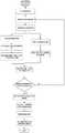
图1多旋翼无人机自动跟随线路飞行和巡检流程图Figure 1 Flowchart of multi-rotor UAV automatically following the line for flight and inspection
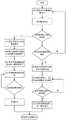
图2多旋翼无人机自动长距离飞行和自动绕障流程图Figure 2 Flow chart of automatic long-distance flight and automatic obstacle avoidance of multi-rotor UAV
图3多旋翼无人机自动控制系统结构图Figure 3 Structure diagram of automatic control system of multi-rotor UAV
具体实施方式Detailed ways
下面结合附图与实施例对本发明做进一步说明The present invention will be further described below in conjunction with the accompanying drawings and embodiments
如图1所示,一种无人机自动跟随线路飞行和巡检的控制算法及流程:As shown in Figure 1, a control algorithm and process for UAV to automatically follow the line to fly and inspect:
1.无人机垂直起飞,飞行控制单元实时处理机器视觉单元中的数据1. The drone takes off vertically, and the flight control unit processes the data in the machine vision unit in real time
2.机器视觉单元将输电线路中的图像送入到图像处理模块中,图像处理模块先对图像采用canny边缘检测以得到轮廓图像,接着使用OpenCV中的hough变换检测轮廓图像中的输电线路,获取各条输电线路在图像的起始点和结束点,同时得到输电线路在图像中的宽度。机器视觉单元根据获得这一数据去计算各条输电线路位于图像中的位置和方向,以及各条输电线路在图像中的相对距离。机器视觉单元将处理完成之后的信息发送给飞行控制单元。2. The machine vision unit sends the image in the transmission line to the image processing module. The image processing module first uses canny edge detection on the image to obtain the contour image, and then uses the hough transform in OpenCV to detect the transmission line in the contour image, and obtains Each transmission line is at the start point and end point of the image, and the width of the transmission line in the image is obtained at the same time. The machine vision unit calculates the position and direction of each transmission line in the image according to the obtained data, as well as the relative distance of each transmission line in the image. The machine vision unit sends the processed information to the flight control unit.
3.在地面人员锁定无人机相对输电线路位置时,飞行控制单元保存一组图像处理模块发送过来的输电线路的数据。接下来飞行控制单元会不断重复如下的过程:3. When the ground personnel lock the position of the UAV relative to the transmission line, the flight control unit saves a set of transmission line data sent by the image processing module. Next, the flight control unit will continue to repeat the following process:
<1>飞行控制单元将当前图像处理模块提供的输电线路的位置信息和保存的位置作比较,以位置的变化量作为控制量调整无人机的飞行姿态和飞行高度,使图像中输电线始终保持在无人机相对位置锁定时的位置。<1> The flight control unit compares the position information of the power transmission line provided by the current image processing module with the saved position, and uses the change in position as the control amount to adjust the flight attitude and flight height of the UAV, so that the power line in the image is always Holds the position when the relative position of the drone is locked.
<2>飞行控制单元将当前图像处理模块提供的输电线路的方向信息和保存的方向作比较,以方向变化量作为控制量调整无人机的飞行姿态和飞行高度,使图像中输电线路始终保持在无人机相对位置锁定时的方向。<2> The flight control unit compares the direction information of the transmission line provided by the current image processing module with the saved direction, and uses the direction change as the control amount to adjust the flight attitude and flight height of the UAV, so that the transmission line in the image is always maintained Orientation when the relative position of the drone is locked.
<3>飞行控制单元将当前图像处理模块提供的输电线路的间距信息和保存的间距作比较,以间距的变化量作为控制量调整无人机的飞行姿态和飞行高度,使图像中各条输电线之间的间距始终保持在无人机相对位置锁定时的间距。<3> The flight control unit compares the distance information of the transmission line provided by the current image processing module with the saved distance, and uses the change of the distance as the control amount to adjust the flight attitude and flight height of the UAV, so that each transmission line in the image can be adjusted. The spacing between lines is always the same as when the relative position of the drone is locked.
4.无人机在完成上述的控制后,各条输电线路位于图像中的位置和方向以及各条输电线路在图像中的相对距离,即无人机相对输电线路的位置、方向和高度就能够稳定在一个较小的范围内。在这种状态下无人机上的摄像头可以拍摄到相对稳定和清晰的输电线路的图像,并不断的将图像发送给地面的观测人员,同时无人机会按照一定的速度沿着输电线路飞行。4. After the UAV completes the above control, the position and direction of each transmission line in the image and the relative distance of each transmission line in the image, that is, the position, direction and height of the UAV relative to the transmission line can be calculated. stable within a small range. In this state, the camera on the UAV can capture relatively stable and clear images of the transmission line, and continuously send the image to the observers on the ground. At the same time, the UAV will fly along the transmission line at a certain speed.
本发明中的自动无人机长距离飞行和自动绕障飞行的控制算法及流程如图2所示:The control algorithm and process flow of the automatic UAV long-distance flight and automatic obstacle avoidance flight in the present invention are shown in Figure 2:
1.无人机处于平行跟随输电线路飞行的过程中。1. The drone is in the process of flying parallel to the transmission line.
2.调度电池电压检测单元响应:2. Schedule the battery voltage detection unit to respond:
<1>AD采样电路检测电池电压。<1> The AD sampling circuit detects the battery voltage.
<2>12.6V电压为起飞电池电压,飞行控制单元实时地根据坐标计算当前位置和起飞位置之间的距离,然后结合预设的返航速度计算返航时间,参考当前无人机的电池电量信息判断此时是否应该返航。<2> The voltage of 12.6V is the take-off battery voltage. The flight control unit calculates the distance between the current position and the take-off position according to the coordinates in real time, and then calculates the return time in combination with the preset return speed, and judges with reference to the current battery power information of the drone Whether it should return at this time.
<3>判断步骤<2>中是否返航,是则进入步骤3,否则跳转至步骤5。<3> Determine whether to return home in step <2>, if yes, go to step 3, otherwise go to step 5.
3.无人机首先在水平方向上,朝向远离线路的方向飞行,直至离开输电线路区域,然后快速升高一定高度,进入无障碍空域。3. The drone first flies in the horizontal direction, away from the line, until it leaves the transmission line area, and then quickly rises to a certain height to enter the barrier-free airspace.
4.执行返航指令,调度北斗卫星定位模块响应:4. Execute the return home command and dispatch the Beidou satellite positioning module to respond:
<1>定位当前无人机本体经纬度坐标。<1> Locate the latitude and longitude coordinates of the current drone body.
<2>根据无人机起飞时刻的经纬度坐标和当前坐标,规划无人机返航最短直线路径。在返航途中,实时计算得到无人机坐标与规划航线的差值,利用位置式PID控制算法实时纠正飞行方位误差,保证无人机按照规划航线飞行。<2> According to the latitude and longitude coordinates and the current coordinates of the take-off time of the drone, plan the shortest straight-line path for the drone to return home. On the way back to the voyage, the difference between the coordinates of the UAV and the planned route is calculated in real time, and the position-based PID control algorithm is used to correct the flight orientation error in real time to ensure that the UAV flies according to the planned route.
<3>无人机返航飞行至起飞位置,并匀速降落,本次巡检过程结束。<3> The drone flies back to the take-off position and landed at a constant speed. The inspection process is over.
5.24GHZ雷达传感器实时探测前方阈值距离内是否存在障碍物。The 5.24GHZ radar sensor detects in real time whether there are obstacles within the front threshold distance.
6.若自发现障碍物后持续3次接收到障碍物距离信息,确定为障碍物而不是误判,进入步骤7,否则退回步骤1。6. If the obstacle distance information has been received 3 times since the obstacle was discovered, it is determined that it is an obstacle rather than a misjudgment, and go to step 7; otherwise, return to step 1.
7.执行绕障指令,调度北斗卫星定位模块响应:7. Execute the obstacle circumvention command and dispatch the Beidou satellite positioning module to respond:
<1>定位当前无人机本体经纬度坐标。<1> Locate the latitude and longitude coordinates of the current drone body.
<2>根据障碍物与无人机本体相对距离及无人机机头朝向角,计算出障碍物经纬度坐标。<2> Calculate the latitude and longitude coordinates of the obstacle according to the relative distance between the obstacle and the drone body and the heading angle of the drone.
<3>以障碍物经纬度坐标为圆心、当前无人机本体与障碍物距离为半径作半圆弧,将该半圆弧作为规划航线;<3> Make a semi-circle arc with the latitude and longitude coordinates of the obstacle as the center and the distance between the current drone body and the obstacle as the radius, and use the semi-circle arc as the planned route;
8.无人机本体根据规划航线飞行,绕过障碍物;并实时计算得到无人机本体经纬度坐标与规划航线的差值,利用位置式PID控制算法实时纠正飞行方位误差,保证无人机按照规划航线飞行。8. The drone body flies according to the planned route and bypasses obstacles; and calculates the difference between the longitude and latitude coordinates of the drone body and the planned route in real time, and uses the position-based PID control algorithm to correct the flight orientation error in real time to ensure that the drone follows the planned route. Plan flight routes.
9.机器视觉模块实时检测天空图像中是否再次出现完整的输电线路特征;若持续2幅图像检测到完整的输电线路特征,则进入步骤10,否则退回步骤8。9. The machine vision module detects in real time whether complete transmission line features appear again in the sky image; if complete transmission line features are detected in two consecutive images, go to step 10, otherwise return to step 8.
10.无人机继续平行跟随输电线路飞行,停止绕飞动作。10. The drone continues to fly parallel to the transmission line and stops flying around.
最后应说明的是:以上各实施例仅用以说明本发明的技术方案,而非对其限制。Finally, it should be noted that the above embodiments are only used to illustrate the technical solutions of the present invention, but not to limit them.
Claims (10)
Translated fromChinesePriority Applications (1)
| Application Number | Priority Date | Filing Date | Title |
|---|---|---|---|
| CN201710208843.4ACN106873627B (en) | 2017-03-31 | 2017-03-31 | A multi-rotor unmanned aerial vehicle and method for automatic inspection of transmission lines |
Applications Claiming Priority (1)
| Application Number | Priority Date | Filing Date | Title |
|---|---|---|---|
| CN201710208843.4ACN106873627B (en) | 2017-03-31 | 2017-03-31 | A multi-rotor unmanned aerial vehicle and method for automatic inspection of transmission lines |
Publications (2)
| Publication Number | Publication Date |
|---|---|
| CN106873627A CN106873627A (en) | 2017-06-20 |
| CN106873627Btrue CN106873627B (en) | 2020-07-28 |
Family
ID=59160723
Family Applications (1)
| Application Number | Title | Priority Date | Filing Date |
|---|---|---|---|
| CN201710208843.4AExpired - Fee RelatedCN106873627B (en) | 2017-03-31 | 2017-03-31 | A multi-rotor unmanned aerial vehicle and method for automatic inspection of transmission lines |
Country Status (1)
| Country | Link |
|---|---|
| CN (1) | CN106873627B (en) |
Families Citing this family (48)
| Publication number | Priority date | Publication date | Assignee | Title |
|---|---|---|---|---|
| CN107124220A (en)* | 2017-06-30 | 2017-09-01 | 广东电网有限责任公司电力科学研究院 | A kind of unmanned helicopter-mounted satellite communication terminal for electric inspection process |
| CN107272739B (en)* | 2017-07-24 | 2020-09-29 | 湘潭大学 | A kind of spraying system and method based on sub-mother system |
| CN107481234B (en)* | 2017-08-23 | 2021-11-26 | 中国电力科学研究院 | Test method for testing visible light imaging performance of unmanned aerial vehicle inspection system |
| CN107884781B (en)* | 2017-11-07 | 2020-06-02 | 北京电子工程总体研究所 | Tracking and ranging method for double unmanned aerial vehicles |
| CN107943074A (en)* | 2017-11-20 | 2018-04-20 | 国网山东省电力公司莱芜供电公司 | A kind of miniature multi-rotor unmanned aerial vehicle safe spacing of electric inspection process keeps system |
| CN108132675B (en)* | 2017-11-23 | 2020-02-21 | 东南大学 | A factory inspection UAV autonomous path cruise and intelligent obstacle avoidance method |
| CN109961466A (en)* | 2017-12-14 | 2019-07-02 | 翔升(上海)电子技术有限公司 | Ranch animals monitoring method and system |
| CN107885229A (en)* | 2017-12-15 | 2018-04-06 | 上海达实联欣科技发展有限公司 | A kind of unmanned plane and its electric power line inspection method of achievable power line automatic detecting |
| CN108521809A (en)* | 2017-12-18 | 2018-09-11 | 深圳市大疆创新科技有限公司 | Obstacle information reminding method, system, unit and recording medium |
| CN109995991A (en)* | 2017-12-29 | 2019-07-09 | 深圳市优必选科技有限公司 | A shooting method, robot and mobile terminal |
| CN108270998A (en)* | 2018-01-19 | 2018-07-10 | 中国农业科学院农业信息研究所 | A kind of farmland image capturing system |
| CN108263606B (en)* | 2018-01-29 | 2020-12-18 | 四川尚航智能科技有限公司 | Vertical take-off and landing fixed wing-based unmanned aerial vehicle and natural gas pipeline inspection system and method thereof |
| CN108334113A (en)* | 2018-04-19 | 2018-07-27 | 北京邮电大学 | Unmanned plane deicing system and method |
| CN109002048B (en)* | 2018-06-12 | 2020-06-09 | 浙江大学 | Multi-rotor unmanned aerial vehicle large-scale centralized photovoltaic power station image data acquisition method |
| CN108919821A (en)* | 2018-06-12 | 2018-11-30 | 浙江大学 | A kind of unmanned plane automatic tour inspection system and method towards scale centralization photovoltaic plant |
| CN108628347B (en)* | 2018-06-29 | 2021-08-31 | 广东电网有限责任公司广州供电局 | Inspection robot, inspection robot autonomous online method and device |
| CN108983809A (en)* | 2018-07-16 | 2018-12-11 | 福州日兆信息科技有限公司 | The method and unmanned plane of accurate identification positioning surrounding based on unmanned plane |
| CN109387741B (en)* | 2018-10-18 | 2021-06-15 | 国网河北省电力有限公司沧州供电分公司 | Line fault repair method based on Beidou positioning system |
| CN109406941B (en)* | 2018-10-18 | 2021-12-24 | 国网河北省电力有限公司沧州供电分公司 | Fault monitoring system based on Beidou positioning system |
| CN110031828A (en)* | 2018-10-22 | 2019-07-19 | 国网浙江省电力有限公司检修分公司 | A kind of unmanned plane range-measurement system and method based on transmission line of electricity magnetic distribution |
| CN110799924A (en)* | 2018-10-26 | 2020-02-14 | 深圳市大疆创新科技有限公司 | Control method and device for unmanned aerial vehicle, unmanned aerial vehicle and computer readable storage medium |
| CN109765930B (en)* | 2019-01-29 | 2021-11-30 | 理光软件研究所(北京)有限公司 | Unmanned aerial vehicle vision navigation |
| CN111580542B (en)* | 2019-02-15 | 2024-07-19 | 北京京东乾石科技有限公司 | Dynamic UAV formation control method, device and storage medium |
| CN110113570A (en)* | 2019-05-07 | 2019-08-09 | 江苏方天电力技术有限公司 | A kind of autonomous cruising inspection system of power transmission line unmanned machine and its working method |
| CN110134148A (en)* | 2019-05-24 | 2019-08-16 | 中国南方电网有限责任公司超高压输电公司检修试验中心 | A kind of transmission line of electricity helicopter make an inspection tour in tracking along transmission line of electricity |
| CN110209196A (en)* | 2019-06-21 | 2019-09-06 | 绿漫科技有限公司 | A kind of unmanned plane garden night watching method and system |
| CN110395398B (en)* | 2019-09-05 | 2023-09-08 | 广东电网有限责任公司 | Grounding assembly system based on multi-rotor unmanned aerial vehicle and grounding method thereof |
| CN110850889B (en)* | 2019-11-18 | 2023-05-23 | 国网江苏省电力有限公司泰州供电分公司 | A UAV autonomous inspection system based on RTK navigation |
| CN111272148B (en)* | 2020-01-20 | 2021-08-31 | 江苏方天电力技术有限公司 | Adaptive imaging quality optimization method for autonomous inspection of transmission lines by unmanned aerial vehicle |
| CN111398682A (en)* | 2020-04-22 | 2020-07-10 | 安徽东源电力有限公司 | Method for measuring by using unmanned aerial vehicle in distribution line design stage |
| CN111625017B (en)* | 2020-04-24 | 2021-04-23 | 滨州学院 | Many rotor unmanned aerial vehicle intelligence system of patrolling and examining |
| CN111814547A (en)* | 2020-06-03 | 2020-10-23 | 国网浙江嘉善县供电有限公司 | A system and method for tracking and detecting overhead high-voltage conductors based on visual recognition |
| CN111766897B (en)* | 2020-07-10 | 2024-02-27 | 广东电网有限责任公司 | Channel inspection method, unmanned aerial vehicle and system for power transmission line |
| CN112180942A (en)* | 2020-10-19 | 2021-01-05 | 广东电网有限责任公司 | Power transmission line autonomous line-tracing inspection system and method and terminal equipment |
| CN112306093B (en)* | 2020-10-30 | 2023-04-07 | 卓旺(安徽)航空科技产业股份有限公司 | Extra-high voltage power grid unmanned aerial vehicle autonomous automatic channel inspection system |
| CN112164015B (en)* | 2020-11-30 | 2021-04-23 | 中国电力科学研究院有限公司 | Monocular vision autonomous inspection image acquisition method, device and power inspection UAV |
| CN112731960A (en)* | 2020-12-02 | 2021-04-30 | 国网辽宁省电力有限公司阜新供电公司 | Unmanned aerial vehicle remote power transmission line intelligent inspection system and method |
| CN112486199A (en)* | 2020-12-11 | 2021-03-12 | 国网辽宁省电力有限公司沈阳供电公司 | Unmanned aerial vehicle inspection control system and method suitable for remote power transmission tower group |
| CN112748744A (en)* | 2020-12-29 | 2021-05-04 | 广东极臻智能科技有限公司 | Transformer substation amphibious inspection device and inspection method thereof |
| CN112748121B (en)* | 2020-12-31 | 2022-10-25 | 天津大学 | UAV detection method and device based on surface cracks of hydraulic structure |
| CN112882490A (en)* | 2021-01-13 | 2021-06-01 | 华东交通大学 | Railway inspection unmanned aerial vehicle based on 5G technology |
| CN112947542A (en)* | 2021-01-25 | 2021-06-11 | 国网甘肃省电力公司电力科学研究院 | Artificial intelligence inspection system based on unmanned aerial vehicle |
| CN114120467B (en)* | 2021-11-30 | 2024-01-26 | 江苏思极科技服务有限公司 | Unmanned aerial vehicle power inspection system and method based on 5G cross-regional remote control |
| CN115063901B (en)* | 2022-04-27 | 2024-11-15 | 大连船舶重工集团有限公司 | A method for automatic ship inspection |
| CN116027798B (en)* | 2022-09-30 | 2023-11-17 | 三峡大学 | UAV power inspection system and method based on image correction |
| CN117876624B (en)* | 2024-03-13 | 2024-05-07 | 纵古(江苏)智能科技有限公司 | Complex environment track planning method based on unmanned aerial vehicle remote sensing image |
| CN118068850B (en)* | 2024-04-17 | 2024-07-19 | 泰诺尔(北京)科技有限公司 | Unmanned aerial vehicle return control method and system |
| CN119472723A (en)* | 2024-11-13 | 2025-02-18 | 广西星湖新能源有限公司 | A transmission line inspection control method and system based on unmanned aerial vehicle |
Family Cites Families (13)
| Publication number | Priority date | Publication date | Assignee | Title |
|---|---|---|---|---|
| US8359542B2 (en)* | 2010-08-13 | 2013-01-22 | Lockheed Martin Corporation | Machines, program products, and computer-implemented methods for interactive aircraft performance substantiation |
| CN102570345B (en)* | 2011-09-19 | 2014-05-28 | 天津全华时代航天科技发展有限公司 | UAV (unmanned aerial vehicle) transmission-line patrolling system |
| CN102591355B (en)* | 2012-02-24 | 2014-06-11 | 山东电力研究院 | Method for detecting safe power-line-cruising distance of UAV (unmanned aerial vehicle) |
| CN103488988B (en)* | 2013-09-06 | 2017-02-01 | 广东电网公司电力科学研究院 | Method for extracting insulators in electrical equipment based on unmanned aerial vehicle line patrol visible light image |
| CN103730862A (en)* | 2013-11-12 | 2014-04-16 | 广东威恒电力技术开发有限公司 | Unmanned aerial vehicle platform power line patrol system and work mode |
| CN103941746B (en)* | 2014-03-29 | 2016-06-01 | 国家电网公司 | Image processing system and method is patrolled and examined without man-machine |
| CN104601956A (en)* | 2015-01-15 | 2015-05-06 | 西安工程大学 | Power transmission line online monitoring system and method based on fixed-wing unmanned aerial vehicle |
| CN104865971B (en)* | 2015-05-26 | 2017-07-28 | 广西大学 | The control method and unmanned plane of a kind of polling transmission line unmanned plane |
| CN105278543A (en)* | 2015-09-28 | 2016-01-27 | 小米科技有限责任公司 | Method and device for increasing flight security, and electronic equipment |
| CN106092054A (en)* | 2016-05-30 | 2016-11-09 | 广东能飞航空科技发展有限公司 | A kind of power circuit identification precise positioning air navigation aid |
| CN106155086B (en)* | 2016-08-09 | 2018-10-30 | 长安大学 | A kind of Road Detection unmanned plane and its automatic cruising method |
| CN106356757B (en)* | 2016-08-11 | 2018-03-20 | 河海大学常州校区 | A kind of power circuit unmanned plane method for inspecting based on human-eye visual characteristic |
| CN106371456B (en)* | 2016-08-31 | 2019-08-16 | 中测新图(北京)遥感技术有限责任公司 | A kind of unmanned plane patrolling method and system |
- 2017
- 2017-03-31CNCN201710208843.4Apatent/CN106873627B/ennot_activeExpired - Fee Related
Also Published As
| Publication number | Publication date |
|---|---|
| CN106873627A (en) | 2017-06-20 |
Similar Documents
| Publication | Publication Date | Title |
|---|---|---|
| CN106873627B (en) | A multi-rotor unmanned aerial vehicle and method for automatic inspection of transmission lines | |
| US11604479B2 (en) | Methods and system for vision-based landing | |
| US9851716B2 (en) | Unmanned aerial vehicle and methods for controlling same | |
| US9641810B2 (en) | Method for acquiring images from arbitrary perspectives with UAVs equipped with fixed imagers | |
| JP6390013B2 (en) | Control method for small unmanned aerial vehicles | |
| CN106155086B (en) | A kind of Road Detection unmanned plane and its automatic cruising method | |
| CN106647804B (en) | A kind of automatic detecting method and system | |
| CN107820585B (en) | Aircraft landing method, aircraft, and computer-readable storage medium | |
| CN110333735B (en) | A system and method for realizing secondary positioning of unmanned aerial vehicle in water and land | |
| US20180005534A1 (en) | Autonomous navigation of an unmanned aerial vehicle | |
| CN112650267B (en) | Flight control method and device of aircraft and aircraft | |
| CN105182992A (en) | Unmanned aerial vehicle control method and device | |
| CN109665099B (en) | Unmanned aerial vehicle and overhead line shooting method | |
| CN113795805A (en) | Flight control method of unmanned aerial vehicle and unmanned aerial vehicle | |
| CN111443727A (en) | A flight control management system and method for a multi-rotor unmanned aerial vehicle | |
| CN107069859A (en) | A kind of wireless charging system and method based on unmanned plane base station | |
| CN108983809A (en) | The method and unmanned plane of accurate identification positioning surrounding based on unmanned plane | |
| EP3077760A1 (en) | Payload delivery | |
| CN106483969A (en) | A kind of many rotors vision tracking unmanned plane | |
| CN105388908A (en) | Machine vision-based unmanned aerial vehicle positioned landing method and system | |
| CN111650962A (en) | Multi-rotor unmanned aerial vehicle route planning and aerial photography method suitable for banded survey area | |
| WO2018059398A1 (en) | Method, apparatus, and system for controlling multi-rotor aircraft | |
| JP6393157B2 (en) | Spacecraft search and recovery system | |
| CN115237158A (en) | Multi-rotor unmanned aerial vehicle autonomous tracking and landing control system and control method | |
| CN115493594A (en) | Patrol control system and method based on BIM |
Legal Events
| Date | Code | Title | Description |
|---|---|---|---|
| PB01 | Publication | ||
| PB01 | Publication | ||
| SE01 | Entry into force of request for substantive examination | ||
| SE01 | Entry into force of request for substantive examination | ||
| GR01 | Patent grant | ||
| GR01 | Patent grant | ||
| CF01 | Termination of patent right due to non-payment of annual fee | Granted publication date:20200728 | |
| CF01 | Termination of patent right due to non-payment of annual fee |