CN103778413A - Remote-sensing image under-segmentation object automatic recognition method - Google Patents
Remote-sensing image under-segmentation object automatic recognition methodDownload PDFInfo
- Publication number
- CN103778413A CN103778413ACN201410020193.7ACN201410020193ACN103778413ACN 103778413 ACN103778413 ACN 103778413ACN 201410020193 ACN201410020193 ACN 201410020193ACN 103778413 ACN103778413 ACN 103778413A
- Authority
- CN
- China
- Prior art keywords
- grid
- pixel
- segmented
- under
- image
- Prior art date
- Legal status (The legal status is an assumption and is not a legal conclusion. Google has not performed a legal analysis and makes no representation as to the accuracy of the status listed.)
- Granted
Links
- 238000000034methodMethods0.000titleclaimsabstractdescription54
- 230000003595spectral effectEffects0.000claimsabstractdescription13
- 230000009467reductionEffects0.000claimsabstractdescription6
- 230000011218segmentationEffects0.000claimsdescription33
- 238000004364calculation methodMethods0.000claimsdescription10
- 230000009466transformationEffects0.000claimsdescription10
- 235000002566CapsicumNutrition0.000claimsdescription3
- 239000006002PepperSubstances0.000claimsdescription3
- 235000016761Piper aduncumNutrition0.000claimsdescription3
- 235000017804Piper guineenseNutrition0.000claimsdescription3
- 235000008184Piper nigrumNutrition0.000claimsdescription3
- 230000001174ascending effectEffects0.000claimsdescription3
- 150000003839saltsChemical class0.000claimsdescription3
- 244000203593Piper nigrumSpecies0.000claims1
- 238000003709image segmentationMethods0.000abstractdescription22
- 239000000203mixtureSubstances0.000description10
- 238000012545processingMethods0.000description5
- 238000010586diagramMethods0.000description4
- 230000001186cumulative effectEffects0.000description3
- 238000005516engineering processMethods0.000description3
- 238000000605extractionMethods0.000description3
- 238000002156mixingMethods0.000description3
- 230000008569processEffects0.000description3
- 238000011160researchMethods0.000description3
- 241000283070Equus zebraSpecies0.000description2
- 241000722363PiperSpecies0.000description2
- 238000004458analytical methodMethods0.000description2
- 239000004568cementSubstances0.000description2
- 238000010191image analysisMethods0.000description2
- 230000002776aggregationEffects0.000description1
- 238000004220aggregationMethods0.000description1
- 238000013528artificial neural networkMethods0.000description1
- 230000009286beneficial effectEffects0.000description1
- 238000006243chemical reactionMethods0.000description1
- 230000007547defectEffects0.000description1
- 238000001514detection methodMethods0.000description1
- 230000004069differentiationEffects0.000description1
- 230000000694effectsEffects0.000description1
- 238000002474experimental methodMethods0.000description1
- 230000006872improvementEffects0.000description1
- 230000002427irreversible effectEffects0.000description1
- 238000003064k means clusteringMethods0.000description1
- 239000000463materialSubstances0.000description1
- 238000000513principal component analysisMethods0.000description1
- 238000012216screeningMethods0.000description1
- 238000007619statistical methodMethods0.000description1
- 238000012706support-vector machineMethods0.000description1
- 238000012360testing methodMethods0.000description1
Images


Landscapes
- Image Analysis (AREA)
Abstract
Translated fromChineseDescription
Translated fromChinese技术领域technical field
本发明属于遥感数据处理领域,涉及一种高分辨率遥感影像欠分割对象自动识别方法。The invention belongs to the field of remote sensing data processing, and relates to an automatic identification method for under-segmented objects of high-resolution remote sensing images.
背景技术Background technique
图像分割是计算机视觉研究中的一个经典难题,是实现图像对象信息提取的重要环节,通过图像分割生成图像对象后,进一步的图像分析(例如面向对象的特征提取和目标识别与图像分类)与理解才能展开。所以,图像分割的好坏将直接影响到后续的图像分析精度。如何高效准确地使分割效果与实际地物相匹配已成为图像理解领域关注的一个热点。Image segmentation is a classic problem in computer vision research, and it is an important link to realize image object information extraction. After image objects are generated through image segmentation, further image analysis (such as object-oriented feature extraction and target recognition and image classification) and understanding to expand. Therefore, the quality of image segmentation will directly affect the accuracy of subsequent image analysis. How to efficiently and accurately match the segmentation effect with the actual ground objects has become a hot spot in the field of image understanding.
目前,图像分割技术主要可分为包括基于区域的分割技术、基于边缘的分割技术和两者结合在内的传统图像分割方法,以及与特定理论结合的图像分割方法,包括基于数学形态学、模糊理论集、神经网络、支持向量机、小波分析和多尺度图像分割等等分割方法。虽然众多新方法已经在原基础上不断改进以避免图像分割的欠分割和过分割带来的矛盾,但仍没有一个通用的分割方法可以解决图像局部欠分割的问题。由于分割对象是图像后续信息提取和目标识别的最小单位,若存在欠分割现象将给后续图像处理带来不可逆转的误差。At present, image segmentation technology can be mainly divided into traditional image segmentation methods including region-based segmentation technology, edge-based segmentation technology and the combination of the two, as well as image segmentation methods combined with specific theories, including based on mathematical morphology, fuzzy Segmentation methods such as theoretical sets, neural networks, support vector machines, wavelet analysis, and multi-scale image segmentation. Although many new methods have been continuously improved on the original basis to avoid the contradictions caused by under-segmentation and over-segmentation of image segmentation, there is still no general segmentation method that can solve the problem of local under-segmentation of images. Since the segmented object is the smallest unit of image subsequent information extraction and target recognition, under-segmentation will bring irreversible errors to subsequent image processing.
以往对于欠分割现象的改善方法大多是在图像分割方法本身做改进以减少欠分割现象,或通过以增加图像计算量为代价把图像做过分割处理以保证最小对象的纯度。这些方法在减少欠分割现象的同时,又增添了其他矛盾(例如增加了进行图像分割的时间成本和后续建立图像分类规则的复杂化)。也有从分割对象角度为研究出发点,通过光谱值来聚类,适合于聚成两类的判定为欠分割对象,否则为单一对象。但该方法无法解释对象纹理形似斑马线状或明暗交织的灌木丛实为单一对象却被判为欠分割对象的情况。In the past, most of the improvement methods for under-segmentation were to improve the image segmentation method itself to reduce under-segmentation, or to segment the image at the cost of increasing the amount of image calculation to ensure the purity of the smallest object. While reducing under-segmentation, these methods add other contradictions (such as increasing the time cost of image segmentation and complicating the subsequent establishment of image classification rules). There is also a research starting point from the perspective of segmented objects, clustering by spectral values, and those that are suitable for clustering into two categories are judged as under-segmented objects, otherwise they are single objects. However, this method cannot explain the situation that the texture of the object looks like a zebra crossing or the bushes with intertwined light and dark are actually a single object but are judged as under-segmented objects.
发明内容Contents of the invention
本发明克服现有技术中图像分割计算量大、分割过程中易产生其他矛盾以及产生错误的欠分割对象等缺陷,提出了一种基于对象纹理混杂度的高分辨率遥感影像欠分割对象识别方法。The present invention overcomes the defects in the prior art that image segmentation has a large amount of calculation, other contradictions are easily generated during the segmentation process, and wrong under-segmented objects are generated, and a method for recognizing under-segmented objects in high-resolution remote sensing images based on object texture hybridity is proposed. .
本发明提出了一种遥感影像欠分割对象识别方法,包括如下步骤:步骤a.对图像进行数据降维,获取分割对象;步骤b.将所述分割对象中的像元进行聚类;步骤c.根据聚类计算所述分割对象的混杂度指标(MD,Mixed Degree);步骤d.根据所述混杂度指标在所述分割对象中识别欠分割对象。The present invention proposes a remote sensing image under-segmented object recognition method, comprising the following steps: step a. performing data dimensionality reduction on the image to obtain the segmented object; step b. clustering the pixels in the segmented object; step c . Calculate the mixed degree index (MD, Mixed Degree) of the segmented object according to the clustering; step d. identify under-segmented objects in the segmented object according to the mixed degree index.
本发明提出的遥感影像欠分割对象识别方法中,所述步骤a包括:a1.通过主成分变换压缩所述图像得到待处理的波段与分割对象信息;a2.根据所述分割对象信息分割所述图像;a3.筛选分割后的图像得到分割对象。In the remote sensing image under-segmentation object recognition method proposed by the present invention, the step a includes: a1. Compressing the image through principal component transformation to obtain the band to be processed and segmentation object information; a2. Segmenting the image according to the segmentation object information Image; a3. Filter the segmented image to obtain the segmented object.
本发明提出的遥感影像欠分割对象识别方法中,所述步骤b包括:b1.确定所述分割对象的像元值的初始聚类中心C1,C2;b2.对所述初始聚类中心进行Kmeans聚类,得到类别U1与类别U2。In the remote sensing image under-segmented object recognition method proposed by the present invention, the step b includes: b1. determining the initial cluster centers C1 and C2 of the pixel values of the segmented objects; b2. performing Kmeans on the initial cluster centers Clustering to get category U1 and category U2.
本发明提出的遥感影像欠分割对象识别方法中,所述初始聚类中心如下式表示:In the remote sensing image under-segmented object recognition method proposed by the present invention, the initial clustering center is represented by the following formula:
其中,
式中,C1与C2表示初始聚类中心,k表示主成分层数,n为分割对象的像元数,xbi表示第b主成分层的第i个像元的光谱值,表示第b主成分层所有像元的平均光谱值,sb表示表示第b主成分层的像元值的标准差。In the formula, C1 and C2 represent the initial clustering centers, k represents the number of principal component layers, n represents the number of pixels of the segmentation object, xbi represents the spectral value of the i-th pixel of the b-th principal component layer, Indicates the average spectral value of all pixels in the b-th principal component layer, and sb represents the standard deviation of the pixel values in the b-th principal component layer.
本发明提出的遥感影像欠分割对象识别方法中,所述Kmeans聚类包括如下步骤:b21.分别计算像元与所述初始聚类中心C1,C2之间的距离,若所述像元与初始聚类中心C1的距离ri1小于像元与初始聚类中心C2的距离ri2,则该像元归入类别U1,否则该像元归入类别U2;b22.利用均值方法重新计算类别U1和类别U2的中心,若计算前后的中心保持不变则执行下一步骤,否则重新开始执行步骤b21。In the remote sensing image under-segmentation object recognition method proposed by the present invention, the Kmeans clustering includes the following steps: b21. Calculate the distance between the pixel and the initial clustering center C1, C2 respectively, if the pixel is different from the initial If the distance ri1 of the clustering center C1 is less than the distance ri2 between the pixel and the initial clustering center C2, the pixel is classified into the category U1, otherwise the pixel is classified into the category U2; b22. Use the mean method to recalculate the category U1 and category U2 , if the center before and after calculation remains unchanged, execute the next step, otherwise, restart step b21.
本发明提出的遥感影像欠分割对象识别方法中,所述步骤b中进一步包括:b3.对所述分割对象进行去除噪声处理。In the remote sensing image under-segmented object recognition method proposed by the present invention, the step b further includes: b3. performing noise removal processing on the segmented object.
本发明提出的遥感影像欠分割对象识别方法中,所述步骤c包括:c1.在所述图像上叠加网格图,所述网格图的尺寸为所述图像的一半;c2.统计每个网格内原始像元数信息;所述原始像元数信息包括网格内背景值像元数T0、网格内类别U1的像元数T1和网格内类别U2的像元数T2;c3.根据所述原始像元数信息计算纯像元网格数和混合像元网格数;c4.根据所述纯像元网格数和混合像元网格数计算混杂度指标。In the remote sensing image under-segmented object recognition method proposed by the present invention, the step c includes: c1. superimposing a grid map on the image, and the size of the grid map is half of the image; c2. counting each Original pixel number information in the grid; the original pixel number information includes the background value pixel number T0 in the grid, the pixel number T1 of the category U1 in the grid and the pixel number T2 of the category U2 in the grid; c3 . Calculate the number of pure pixel grids and the number of mixed pixel grids according to the original pixel number information; c4. Calculate the confusion index according to the number of pure pixel grids and mixed pixel grids.
本发明提出的遥感影像欠分割对象识别方法中,在所述步骤c3中,当网格内T1=0,T2≠0或T1≠0,T2=0时,该网格是纯网格,其纯像元网格数Pure_i如下式表示:

本发明提出的遥感影像欠分割对象识别方法中,所述混杂度指标如以下公式所示:In the remote sensing image under-segmented object recognition method proposed by the present invention, the confusion index is shown in the following formula:
式中,MD表示混杂度指标,Mix表示混合像元网格数,Pure表示纯像元网格数。In the formula, MD represents the index of complexity, Mix represents the number of mixed pixel grids, and Pure represents the number of pure pixel grids.
本发明提出的遥感影像欠分割对象识别方法中,所述步骤d包括:d1.按所述混杂度指标对所述分割对象进行升序排序;d2.设定阈值,将序号小于阈值的分割对象作为欠分割对象。In the remote sensing image under-segmented object recognition method proposed by the present invention, the step d includes: d1. sorting the segmented objects in ascending order according to the complexity index; Under-segmented objects.
本发明利用主成分变换原理,将更多的信息重组在更少的数据量中。通过度量待判定分割对象被聚为两类后,根据混杂程度进行欠分割对象的判定。本发明通过叠加更粗精度的网格,计算每个网格内的纯像元网格数和混合像元网格数,求和整个对象所有网格内的纯像元网格数和混合像元网格数得到分割对象的混杂度指标,从而根据混杂度指标判定是否为欠分割对象。本发明提出的混杂度指标MD值小的,说明混杂度小,可分性好,应判定为欠分割对象。The invention utilizes the principal component transformation principle to reorganize more information into less data volume. After the segmentation objects to be determined are clustered into two categories by measuring, the under-segmentation objects are determined according to the degree of confusion. The present invention calculates the number of pure pixel grids and the number of mixed pixel grids in each grid by superimposing coarser grids, and sums the number of pure pixel grids and mixed images in all grids of the entire object The number of meta-grids is used to obtain the chaos index of the segmented object, so as to judge whether it is an under-segmented object or not according to the chaos index. If the MD value of the ambiguity index proposed by the present invention is small, it means that the ambiguity is small and the separability is good, and it should be judged as an under-segmented object.
本发明对高分辨率遥感影像的欠分割对象检测具有更高的效率,现代高精度的高分遥感影像至少具有4个波段(有些如WorldView2达8个甚至更多波段),计算量大,采用传统分割方法需要对每个图像层进行计算,而本方法仅需3个主成分层的计算量,效率明显提高;且利用混杂度指标判定欠分割对象精度更高,误判率和漏判率明显降低。The present invention has higher efficiency for under-segmented object detection of high-resolution remote sensing images. Modern high-precision remote sensing images have at least 4 bands (some such as WorldView2 up to 8 or more bands), and the amount of calculation is large. The traditional segmentation method needs to calculate each image layer, but this method only needs the calculation amount of three principal component layers, and the efficiency is significantly improved; and the accuracy of judging the under-segmented object by using the confusion index is higher, and the misjudgment rate and missed judgment rate are higher. Obvious reduction.
附图说明Description of drawings
图1是本发明遥感影像欠分割对象识别方法的流程图Fig. 1 is a flow chart of the remote sensing image under-segmented object recognition method of the present invention
图2是实施例中一个欠分割对象在聚类后计算得到的混杂度指标示意图。Fig. 2 is a schematic diagram of a hybrid index calculated after clustering of an under-segmented object in the embodiment.
图3是实施例中一个非欠分割对象在聚类后计算得到的混杂度指标示意图。Fig. 3 is a schematic diagram of a hybrid index calculated after clustering of a non-under-segmented object in the embodiment.
图4是欠分割对象识别方法在WorldView2高分辨率遥感图像分割中的应用实例。Figure 4 is an example of the application of the under-segmented object recognition method in WorldView2 high-resolution remote sensing image segmentation.
图5是非欠分割对象识别方法在WorldView2高分辨率遥感图像分割中的应用实例。Figure 5 is an example of the application of the non-under-segmented object recognition method in WorldView2 high-resolution remote sensing image segmentation.
具体实施方式Detailed ways
结合以下具体实施例和附图,对本发明作进一步的详细说明。实施本发明的过程、条件、实验方法等,除以下专门提及的内容之外,均为本领域的普遍知识和公知常识,本发明没有特别限制内容。The present invention will be further described in detail in conjunction with the following specific embodiments and accompanying drawings. The process, conditions, experimental methods, etc. for implementing the present invention, except for the content specifically mentioned below, are common knowledge and common knowledge in this field, and the present invention has no special limitation content.
本发明遥感影像欠分割对象识别方法首先确定参与图像分割的光谱层,得到分割后的分割对象层,判断每个分割对象的面积(像元数),小于一定值则可忽略不计。若对象面积大于一定阈值,则通过K均值聚类方法将对象分为两类,然后计算对象的混杂度指标(MD)作为判断欠分割的依据。对象的混杂度越低其对象被分为的两类的聚合程度越高,该对象越趋向于欠分割。The remote sensing image under-segmented object recognition method of the present invention firstly determines the spectral layer involved in image segmentation, obtains the segmented object layer after segmentation, and judges the area (number of pixels) of each segmented object, if it is less than a certain value, it can be ignored. If the area of the object is larger than a certain threshold, the object is divided into two categories by the K-means clustering method, and then the mixed degree index (MD) of the object is calculated as the basis for judging under-segmentation. The lower the degree of promiscuity of an object, the higher the degree of aggregation of the two classes into which the object is divided, the more the object tends to be under-segmented.
参阅图1,本发明遥感影像欠分割对象识别方法的具体步骤如下:Referring to Fig. 1, the specific steps of remote sensing image under-segmentation object recognition method of the present invention are as follows:
步骤a:数据降维Step a: Data dimensionality reduction
a1.通过主成分变换压缩图像得到待处理的波段与分割对象信息。主成分变换是设法将原来众多具有一定相关性的变量,重新组合成一组新的互相无关的及格综合变量,同时根据实际需求从中可以取出较少的综合变量尽可能多地反映原来变量的信息。主成分分析是一种多元统计分析方法,也是数学上用来降维的一种方法。利用主成分变换后的综合光谱图像(第一、二、三主成分)作为图像分割的编辑层,并以各主成分的特征值百分比作为权重值。该方法将遥感影像的多波段图像信息压缩到比原波段更有效的少数几个转换波段中,仅利用前三个主成分就可以解释95%以上的图像信息,不仅有利于减少后续处理和分析的数据量,同时主成分变换得到的百分比(即主成分变换层中所涵盖信息量的比重)可作为图像分割时进行权重设置(wc)的客观指标。a1. Compress the image through principal component transformation to obtain the band to be processed and the segmentation object information. Principal component transformation is to try to recombine many original variables with certain correlations into a new group of unrelated and qualified comprehensive variables, and at the same time, according to actual needs, fewer comprehensive variables can be taken out to reflect as much information as possible of the original variables. Principal component analysis is a multivariate statistical analysis method, and it is also a method used in mathematics for dimensionality reduction. The integrated spectral image (the first, second, and third principal components) transformed by the principal components is used as the editing layer of the image segmentation, and the eigenvalue percentage of each principal component is used as the weight value. This method compresses the multi-band image information of remote sensing images into a few conversion bands that are more effective than the original bands, and only uses the first three principal components to explain more than 95% of the image information, which is not only beneficial to reduce subsequent processing and analysis At the same time, the percentage obtained by principal component transformation (that is, the proportion of information covered in the principal component transformation layer) can be used as an objective index for weight setting (wc ) during image segmentation.
a2.根据分割对象信息分割图像。本发明中使用前三个主成分变换层作为图像分割的编辑层,进行有权重设置的图像分割。a2. Segment the image according to the segmentation object information. In the present invention, the first three principal component transformation layers are used as editing layers for image segmentation, and image segmentation with weight setting is performed.
a3.筛选分割后的图像得到分割对象。本发明中通过排除整幅分割图像中面积较小的对象以减少计算成本,面积阈值的确定视遥感影像空间分辨率、图像分割的要素和分割精度而定。例如本实施例中采用空间分辨率为0.5m的WorldView2高分遥感影像,分割的要素是城市地物,那么当对象面积小于500像元时(相当于一个羽毛球片场面积),该对象不参与运算。a3. Filter the segmented image to obtain the segmented object. In the present invention, calculation costs are reduced by excluding objects with smaller areas in the entire segmented image, and the determination of the area threshold depends on the spatial resolution of the remote sensing image, the elements of image segmentation and the segmentation accuracy. For example, in this embodiment, the WorldView2 high-resolution remote sensing image with a spatial resolution of 0.5m is used, and the elements to be segmented are urban features, so when the object area is less than 500 pixels (equivalent to the area of a badminton field), the object does not participate in the calculation .
步骤b:将分割对象中的像元进行聚类。Step b: cluster the pixels in the segmentation object.
b1.确定分割对象的初始聚类中心C1,C2。b1. Determine the initial cluster centers C1 and C2 of the segmented objects.
本实施例采用空间分辨率为0.5m的WorldView2高分遥感影像,其图像信息是混合的地物,利用对象的光谱信息在多光谱特征空间中做固定初始聚类中心C1,C2为中心的两个聚类集类别U1和类别U2。确定初始聚类中心C1和C2,初始聚类中心的计算公式如下:In this embodiment, the WorldView2 high-resolution remote sensing image with a spatial resolution of 0.5m is used. The image information is mixed ground objects. The spectral information of the object is used to make two fixed initial clustering centers C1 and C2 in the multispectral feature space. clustering sets category U1 and category U2. Determine the initial clustering centers C1 and C2, the calculation formula of the initial clustering center is as follows:
其中,
式中,C1与C2表示初始聚类中心,k表示主成分层数,n为对象像元数(即面积),xbi表示第b主成分层的第i个像元的光谱值,
b2.对初始聚类中心进行Kmeans聚类,得到类别U1与类别U2。计算每个像元Pi到C1和C2的距离ri1和ri2,其中,如果ri1<ri2,Pi点归入U1类,否则归入U2类,并利用均值方法重新计算U1和U2的中心,如此反复迭代更新后,直到新老类别中心的值保持不变,则迭代结束,否则继续迭代。b2. Carry out Kmeans clustering on the initial cluster centers to obtain category U1 and category U2. Calculate the distance ri1 and ri2 of each pixel Pi to C1 and C2, where, If ri1 < ri2 , the Pi point is classified into U1 class, otherwise it is classified into U2 class, and the centers of U1 and U2 are recalculated using the mean value method, and after repeated iterative updates, until the values of the new and old class centers remain unchanged, then The iteration ends, otherwise continue to iterate.
b3.去除椒盐噪声的干扰。对聚类后的类别U1作数学形态学的开启闭合操作,去除椒盐点噪声的干扰。本实施例中使用尺寸大小为2的SE对分割对象做开启闭合操作,消除图像中的凸点和凹陷。b3. Remove the interference of salt and pepper noise. Perform mathematical morphology opening and closing operations on the clustered category U1 to remove the interference of salt and pepper point noise. In this embodiment, an SE with a size of 2 is used to perform opening and closing operations on the segmented object to eliminate bumps and depressions in the image.
步骤c.根据聚类计算分割对象的混杂度指标;Step c. Calculate the confusion index of the segmented object according to the clustering;
c1.在图像上叠加网格图,网格图的尺寸为图像的一半。若原始对象的外接矩形为m*n,则在原始对象上叠加一张的网格图,若m或n为奇数,则加1后除以2,以保证能被2整除。c1. Overlay a grid map on the image, the size of the grid map is half of the image. If the bounding rectangle of the original object is m*n, superimpose a sheet on the original object If m or n is an odd number, add 1 and divide by 2 to ensure that it can be divisible by 2.
c2.统计每个网格内原始像元数信息;原始像元数信息包括网格内背景值像元数T0、网格内类别U1的像元数T1和网格内类别U2的像元数T2。c2. Count the original pixel number information in each grid; the original pixel number information includes the background value pixel number T0 in the grid, the pixel number T1 of the category U1 in the grid, and the pixel number of the category U2 in the grid T2.
c3.根据原始像元数信息计算纯像元网格数和混合像元网格数。先计算单个网格内的纯像元网格数Pure_i和混合像元网格数Mix_j:c3. Calculate the pure pixel grid number and the mixed pixel grid number according to the original pixel number information. First calculate the pure cell grid number Pure_i and the mixed pixel grid number Mix_j in a single grid:
若T1=0,T2≠0或T1≠0,T2=0,则说明该网格内只含有类别U2或类别U1,该网格是纯网格,计算纯像元网格数Pure_i,N为网格内像元数,此处N=4。If T1=0, T2≠0 or T1≠0, T2=0, it means that the grid only contains category U2 or category U1, and the grid is a pure grid. Calculate the number of pure pixel grids Pure_i, N is The number of cells in the grid, where N=4.
若T1≠0,且T2≠0,则说明该网格是混合的,即U1类和U2类的交界处,计算混合像元网格数Mix_j,If T1≠0, and T2≠0, it means that the grid is mixed, that is, at the junction of U1 and U2, calculate the mixed pixel grid number Mix_j,
以上两个公式中皆排除了外接矩形的背景值,即排除了分割对象的边界长度和对象形状的干扰,只考虑分割对象内部被强制分为两类时混杂网格数与总的分割对象网格数的比值情况。Both the above two formulas exclude the background value of the circumscribed rectangle, that is, the interference of the boundary length of the segmented object and the object shape are excluded, and only the number of mixed meshes and the total segmented object mesh are considered when the segmented object is forced to be divided into two types. The ratio of grid numbers.
c4.根据纯像元网格数和混合像元网格数计算混杂度指标。c4. Calculate the confusion index according to the pure pixel grid number and the mixed pixel grid number.
累计求和计算上述步骤c3中整个分割对象内所有网格的纯像元网格数Pure和混合像元网格数Mix,然后计算该分割对象的混杂度指标(MD):Cumulatively calculate the pure pixel grid number Pure and the mixed pixel grid number Mix of all grids in the entire segmented object in the above step c3, and then calculate the mixed degree index (MD) of the segmented object:
式中,MD表示混杂度指标,Mix表示混合像元网格数,Pure表示纯像元网格数。In the formula, MD represents the index of complexity, Mix represents the number of mixed pixel grids, and Pure represents the number of pure pixel grids.
步骤d.根据混杂度指标在分割对象中识别欠分割对象。Step d. Identify under-segmented objects among the segmented objects according to the confusion index.
d1.按混杂度指标对分割对象进行升序排序。计算得到整幅影像所有参与计算的分割对象的混杂度指标(MD),该MD值是一个相对值,若MD_x<MD_y,说明相较于x对象,y对象聚类后的两类在空间分布上没有明显界限,更趋向为同一种地物,而x对象两类界限所占整个分割对象的比重较低,说明对象本身的光谱值在空间分布上分异性好于分割对象y,根据实际经验可判断分割对象x比分割对象y更有可能是欠分割对象。d1. Sort the segmentation objects in ascending order according to the complexity index. Calculate the mixed degree index (MD) of all the segmentation objects participating in the calculation of the entire image. The MD value is a relative value. If MD_x<MD_y, it means that compared with the x object, the two types of y objects clustered in the spatial distribution There is no obvious boundary on the object, and it tends to be the same kind of ground object, and the proportion of the two types of boundaries of the object x to the entire segmentation object is relatively low, indicating that the spectral value of the object itself is better in spatial distribution than the segmentation object y. According to practical experience It can be judged that the segmentation object x is more likely to be an under-segmentation object than the segmentation object y.
d2.设定阈值,将序号小于阈值的分割对象作为欠分割对象。一股设定阈值为10-25%,取MD值从小到大排列中的前10%~25%分割对象为欠分割对象进行再分割。该MD值提供了筛选欠分割对象的有效依据,以便后续处理中对欠分割对象进行分割。d2. Set the threshold, and use the segmented objects with serial numbers smaller than the threshold as under-segmented objects. Generally, the threshold is set at 10-25%, and the top 10%-25% of the segmentation objects in the MD value arrangement from small to large are taken as under-segmented objects for re-segmentation. The MD value provides an effective basis for screening under-segmented objects, so that the under-segmented objects can be segmented in subsequent processing.
以下结合示意图对本发明实施混杂度指标MD的过程进行详细描述。The process of implementing the confusion index MD in the present invention will be described in detail below in conjunction with the schematic diagram.
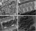
图2和图3为分割对象1(欠分割对象)和分割对象2(非欠分割对象)经过步骤a和步骤b后的聚类示意图。对象1和对象2都接有20*20的外接矩形,在此基础上叠加一张10*10的网格图(即步骤c1),网格图如图2与图3中的粗黑边。Fig. 2 and Fig. 3 are the clustering diagrams of segmentation object 1 (under-segmentation object) and segmentation object 2 (non-under-segmentation object) after step a and step b. Both
欠分割对象往往是材质相接近的不同地物,比如水泥制房屋与房屋周围水泥道路的混合对象。欠分割对象的像元被强制分为两类后,两类的分界线比较明确,判为欠分割对象的概率较高。The under-segmented objects are often different ground objects with similar materials, such as the mixed objects of cement houses and cement roads around the houses. After the pixels of the under-segmented object are forcibly divided into two categories, the boundary between the two categories is relatively clear, and the probability of being judged as an under-segmented object is relatively high.
非欠分割对象往往是由于灌木丛的高低差形成阴影,从而体现在图像像素值上的差异,或类似斑马线纹路的地物,容易分为两类,实则一类地物。非欠分割对象的像元被分为两类后,两类比较混杂,彼此交融混合度较高,界限不明显,判为非欠分割对象的概率较高。Non-under-segmented objects are often due to the height difference of the bushes, which is reflected in the difference in the pixel value of the image, or the ground features similar to the zebra stripes. They are easily divided into two categories, but they are actually one kind of ground features. After the pixels of non-under-segmented objects are divided into two types, the two types are relatively mixed, with a high degree of blending and mixing with each other, and the boundaries are not obvious, so the probability of being judged as non-under-segmented objects is high.
根据步骤c2与c3计算得到每个网格内的T0、T1和T2值,并计算得到每个网格的纯像元网格数(淡色字体)和混合像元网格数(黑色字体)。Calculate the T0, T1 and T2 values in each grid according to steps c2 and c3, and calculate the number of pure pixel grids (light fonts) and mixed pixel grids (black fonts) for each grid.
根据步骤c4对图2的Pure_i和Mix_j累计求和,得到Mix=10.25,Pure=65.75,MD=0.13486;同理,对于图3,Mix=37.5,Pure=27.75,MD=0.57471。According to step c4, the Pure_i and Mix_j in Figure 2 are cumulatively summed to obtain Mix=10.25, Pure=65.75, MD=0.13486; similarly, for Figure 3, Mix=37.5, Pure=27.75, MD=0.57471.
当图2和图3对象被聚类分为两类U1与U2后,判断出图2中U1和U2的分异性很高,混杂度很低,其为将不同属性的两种地物被欠分割为同一个分割对象(比如,遥感影像中的房屋和其阴影),而图3中U1和U2的混杂度很高,因此强制分成两类是不合理的,分割区域更趋向是单一地物(比如,遥感影像中的灌木丛等)。从定量的角度去筛选欠分割对象的话,就是计算整幅影像中所有分割对象的MD指标,MD越小,被判为欠分割对象的可能越大。图2中的MD远小于图3中的MD值,相较图3的对象而言,图2对象为欠分割对象,需要进一步分割。When the objects in Figure 2 and Figure 3 are clustered into two types U1 and U2, it is judged that the differentiation of U1 and U2 in Figure 2 is very high, and the degree of confusion is very low, which means that the two types of ground objects with different attributes are owed Segmented into the same segmented object (for example, the house and its shadow in the remote sensing image), and the U1 and U2 in Figure 3 have a high degree of mixing, so it is unreasonable to force them to be divided into two categories, and the segmented area tends to be a single object (For example, bushes in remote sensing images, etc.). To screen under-segmented objects from a quantitative point of view is to calculate the MD index of all segmented objects in the entire image. The smaller the MD, the greater the possibility of being judged as an under-segmented object. The MD in Figure 2 is much smaller than the MD value in Figure 3. Compared with the object in Figure 3, the object in Figure 2 is an under-segmented object and needs further segmentation.
1.本发明的欠分割对象识别方法在WorldView2高分辨率遥感图像分割中的应用实例。1. An application example of the under-segmented object recognition method of the present invention in WorldView2 high-resolution remote sensing image segmentation.
选取市区一复杂地块(图4)中的三块区域作为研究区,包含居民楼房、单位楼房、绿地、道路等多种地面目标,以检验本文提出方法的适用性。将WorldView2影像的8波段进行主成分变换后(表1),取前三个主成分层(PC1的累积特征百分比70.58%,PC2的累积特征百分比96.80%,PC3的累积特征百分比99.11%)在Definien8.7中进行多尺度分割,并分别将主成分的特征值百分比70、26和2作为三个图像编辑层的权重值参与到图像分割的运算中。Three areas in a complex urban area (Figure 4) are selected as the research area, including residential buildings, unit buildings, green spaces, roads and other ground objects, to test the applicability of the method proposed in this paper. After performing principal component transformation on the 8-band WorldView2 image (Table 1), take the first three principal component layers (the cumulative feature percentage of PC1 is 70.58%, the cumulative feature percentage of PC2 is 96.80%, and the cumulative feature percentage of PC3 is 99.11%) in Definien8 In .7, multi-scale segmentation is carried out, and the eigenvalue percentages of principal components of 70, 26 and 2 are used as the weight values of the three image editing layers to participate in the operation of image segmentation.
表1研究区主成分变换后的统计属性Table 1 Statistical properties of the study area after principal component transformation
获得分割尺度为88时的最优分割图像,含有534个分割对象,排除其中面积(即像元数量)小于500个像元的对象,一共得到400个有效分割对象。将每个分割对象计算得到的MD值从小到大排列,取前20%的对象(80个对象)在图4中进行放大并以高亮轮廓显示。有图4可见,房屋与水泥地面混杂和树木与水泥地面等混杂在一起的欠分割对象都被筛选出来。The optimal segmented image was obtained when the segmentation scale was 88, which contained 534 segmented objects, excluding objects whose area (that is, the number of pixels) was less than 500 pixels, and a total of 400 effective segmented objects were obtained. Arrange the MD values calculated for each segmented object from small to large, and take the top 20% of objects (80 objects) to enlarge and display them as highlighted outlines in Figure 4. As can be seen in Figure 4, the under-segmented objects that are mixed with houses and concrete ground and trees and concrete ground are all filtered out.
反之,当选取用本发明所得的所有MD值中较大的20%对象(80个对象),可以发现筛选出来的多是灌木丛、屋顶和草地等仅包含单一地物的对象。如图5放大区域内高亮轮廓显示的对象。On the contrary, when selecting the larger 20% objects (80 objects) among all MD values obtained by the present invention, it can be found that most of the screened out objects are bushes, roofs and grasslands, etc., which only contain a single feature. Objects shown as highlighted outlines in the zoomed-in area in Figure 5.
通过对比图4和图5可发现,依据本发明所得的MD值排序,可准确地筛选出绝大多数欠分割对象,且排除仅包含单一地物的纯对象。By comparing Fig. 4 and Fig. 5, it can be found that according to the sorting of MD values obtained in the present invention, most under-segmented objects can be accurately screened out, and pure objects containing only a single feature can be excluded.
本发明的保护内容不局限于以上实施例。在不背离发明构思的精神和范围下,本领域技术人员能够想到的变化和优点都被包括在本发明中,并且以所附的权利要求书为保护范围。The protection content of the present invention is not limited to the above embodiments. Without departing from the spirit and scope of the inventive concept, changes and advantages conceivable by those skilled in the art are all included in the present invention, and the appended claims are the protection scope.
Claims (10)
Translated fromChinesePriority Applications (1)
| Application Number | Priority Date | Filing Date | Title |
|---|---|---|---|
| CN201410020193.7ACN103778413B (en) | 2014-01-16 | 2014-01-16 | A kind of remote sensing image less divided object automatic identifying method |
Applications Claiming Priority (1)
| Application Number | Priority Date | Filing Date | Title |
|---|---|---|---|
| CN201410020193.7ACN103778413B (en) | 2014-01-16 | 2014-01-16 | A kind of remote sensing image less divided object automatic identifying method |
Publications (2)
| Publication Number | Publication Date |
|---|---|
| CN103778413Atrue CN103778413A (en) | 2014-05-07 |
| CN103778413B CN103778413B (en) | 2017-03-29 |
Family
ID=50570627
Family Applications (1)
| Application Number | Title | Priority Date | Filing Date |
|---|---|---|---|
| CN201410020193.7AActiveCN103778413B (en) | 2014-01-16 | 2014-01-16 | A kind of remote sensing image less divided object automatic identifying method |
Country Status (1)
| Country | Link |
|---|---|
| CN (1) | CN103778413B (en) |
Cited By (3)
| Publication number | Priority date | Publication date | Assignee | Title |
|---|---|---|---|---|
| CN104392436A (en)* | 2014-11-11 | 2015-03-04 | 莱芜钢铁集团有限公司 | Processing method and device for remote sensing image |
| CN108765426A (en)* | 2018-05-15 | 2018-11-06 | 南京林业大学 | automatic image segmentation method and device |
| CN109933984A (en)* | 2019-02-15 | 2019-06-25 | 中时瑞安(北京)网络科技有限责任公司 | A kind of best cluster result screening technique, device and electronic equipment |
Citations (4)
| Publication number | Priority date | Publication date | Assignee | Title |
|---|---|---|---|---|
| CN1540586A (en)* | 2003-10-30 | 2004-10-27 | �Ϻ���ͨ��ѧ | Method for picking up and comparing spectral features in remote images |
| CN101710419A (en)* | 2009-10-29 | 2010-05-19 | 中国科学院对地观测与数字地球科学中心 | Automatic intelligent method for detecting insufficiently-segmented regions of high-resolution remote sensing image |
| CN101710387A (en)* | 2009-10-29 | 2010-05-19 | 中国科学院对地观测与数字地球科学中心 | Intelligent method for classifying high-resolution remote sensing images |
| US8385662B1 (en)* | 2009-04-30 | 2013-02-26 | Google Inc. | Principal component analysis based seed generation for clustering analysis |
- 2014
- 2014-01-16CNCN201410020193.7Apatent/CN103778413B/enactiveActive
Patent Citations (4)
| Publication number | Priority date | Publication date | Assignee | Title |
|---|---|---|---|---|
| CN1540586A (en)* | 2003-10-30 | 2004-10-27 | �Ϻ���ͨ��ѧ | Method for picking up and comparing spectral features in remote images |
| US8385662B1 (en)* | 2009-04-30 | 2013-02-26 | Google Inc. | Principal component analysis based seed generation for clustering analysis |
| CN101710419A (en)* | 2009-10-29 | 2010-05-19 | 中国科学院对地观测与数字地球科学中心 | Automatic intelligent method for detecting insufficiently-segmented regions of high-resolution remote sensing image |
| CN101710387A (en)* | 2009-10-29 | 2010-05-19 | 中国科学院对地观测与数字地球科学中心 | Intelligent method for classifying high-resolution remote sensing images |
Non-Patent Citations (1)
| Title |
|---|
| 张春林 等: ""顾及混合像元分解的遥感图像光模拟"", 《武汉大学学报•信息科学版》* |
Cited By (3)
| Publication number | Priority date | Publication date | Assignee | Title |
|---|---|---|---|---|
| CN104392436A (en)* | 2014-11-11 | 2015-03-04 | 莱芜钢铁集团有限公司 | Processing method and device for remote sensing image |
| CN108765426A (en)* | 2018-05-15 | 2018-11-06 | 南京林业大学 | automatic image segmentation method and device |
| CN109933984A (en)* | 2019-02-15 | 2019-06-25 | 中时瑞安(北京)网络科技有限责任公司 | A kind of best cluster result screening technique, device and electronic equipment |
Also Published As
| Publication number | Publication date |
|---|---|
| CN103778413B (en) | 2017-03-29 |
Similar Documents
| Publication | Publication Date | Title |
|---|---|---|
| CN109446992B (en) | Remote sensing image building extraction method and system based on deep learning, storage medium and electronic equipment | |
| CN103632363B (en) | Object level high-resolution remote sensing image change detecting method based on Multiscale Fusion | |
| CN105335966B (en) | Multiscale morphology image division method based on local homogeney index | |
| CN103034863B (en) | The remote sensing image road acquisition methods of a kind of syncaryon Fisher and multiple dimensioned extraction | |
| CN106503739A (en) | The target in hyperspectral remotely sensed image svm classifier method and system of combined spectral and textural characteristics | |
| CN111626269A (en) | Practical large-space-range landslide extraction method | |
| CN107358260B (en) | A Multispectral Image Classification Method Based on Surface Wave CNN | |
| CN103077515B (en) | A Method for Building Change Detection in Multispectral Images | |
| CN106846344A (en) | A kind of image segmentation optimal identification method based on the complete degree in edge | |
| CN106296680B (en) | A region-based multi-feature fusion high-resolution remote sensing image segmentation method | |
| CN106611421B (en) | SAR image segmentation method based on feature learning and sketch line segment constraints | |
| CN104361589A (en) | High-resolution remote sensing image segmentation method based on inter-scale mapping | |
| CN103198479B (en) | SAR image segmentation method based on semantic information classification | |
| CN105138970A (en) | Spatial information-based polarization SAR image classification method | |
| CN103559500A (en) | Multispectral remote sensing image land feature classification method based on spectrum and textural features | |
| CN107092871A (en) | Remote sensing image building detection method based on multiple dimensioned multiple features fusion | |
| CN105427313B (en) | SAR image segmentation method based on deconvolution network and adaptive inference network | |
| CN106971397B (en) | Based on the city high-resolution remote sensing image dividing method for improving JSEG algorithms | |
| CN107292328A (en) | The remote sensing image shadow Detection extracting method and system of multiple dimensioned multiple features fusion | |
| CN108960276B (en) | A Sample Expansion and Consistency Discrimination Method to Improve the Performance of Spectral Image Supervised Classification | |
| CN103208121B (en) | Based on the remote sensing image segmentation method that bounds constraint merges with two benches | |
| CN108053412B (en) | Determination method of optimal segmentation result of remote sensing image based on fusion of multiple quantitative evaluation indicators | |
| CN111340761A (en) | Remote sensing image change detection method based on fractal attribute and decision fusion | |
| CN111882573A (en) | A method and system for extracting cultivated land blocks based on high-resolution image data | |
| CN115512159A (en) | Object-Oriented Method and System for Land Cover Classification of High-Resolution Remote Sensing Images |
Legal Events
| Date | Code | Title | Description |
|---|---|---|---|
| C06 | Publication | ||
| PB01 | Publication | ||
| C10 | Entry into substantive examination | ||
| SE01 | Entry into force of request for substantive examination | ||
| GR01 | Patent grant | ||
| GR01 | Patent grant |