CN103760565A - Regional scale forest canopy height remote sensing retrieval method - Google Patents
Regional scale forest canopy height remote sensing retrieval methodDownload PDFInfo
- Publication number
- CN103760565A CN103760565ACN201410046762.5ACN201410046762ACN103760565ACN 103760565 ACN103760565 ACN 103760565ACN 201410046762 ACN201410046762 ACN 201410046762ACN 103760565 ACN103760565 ACN 103760565A
- Authority
- CN
- China
- Prior art keywords
- forest
- remote sensing
- canopy
- canopy height
- height
- Prior art date
- Legal status (The legal status is an assumption and is not a legal conclusion. Google has not performed a legal analysis and makes no representation as to the accuracy of the status listed.)
- Pending
Links
Images


Classifications
- G—PHYSICS
- G01—MEASURING; TESTING
- G01S—RADIO DIRECTION-FINDING; RADIO NAVIGATION; DETERMINING DISTANCE OR VELOCITY BY USE OF RADIO WAVES; LOCATING OR PRESENCE-DETECTING BY USE OF THE REFLECTION OR RERADIATION OF RADIO WAVES; ANALOGOUS ARRANGEMENTS USING OTHER WAVES
- G01S17/00—Systems using the reflection or reradiation of electromagnetic waves other than radio waves, e.g. lidar systems
- G01S17/88—Lidar systems specially adapted for specific applications
- G—PHYSICS
- G01—MEASURING; TESTING
- G01S—RADIO DIRECTION-FINDING; RADIO NAVIGATION; DETERMINING DISTANCE OR VELOCITY BY USE OF RADIO WAVES; LOCATING OR PRESENCE-DETECTING BY USE OF THE REFLECTION OR RERADIATION OF RADIO WAVES; ANALOGOUS ARRANGEMENTS USING OTHER WAVES
- G01S13/00—Systems using the reflection or reradiation of radio waves, e.g. radar systems; Analogous systems using reflection or reradiation of waves whose nature or wavelength is irrelevant or unspecified
- G01S13/88—Radar or analogous systems specially adapted for specific applications
- G01S13/882—Radar or analogous systems specially adapted for specific applications for altimeters
- G—PHYSICS
- G01—MEASURING; TESTING
- G01S—RADIO DIRECTION-FINDING; RADIO NAVIGATION; DETERMINING DISTANCE OR VELOCITY BY USE OF RADIO WAVES; LOCATING OR PRESENCE-DETECTING BY USE OF THE REFLECTION OR RERADIATION OF RADIO WAVES; ANALOGOUS ARRANGEMENTS USING OTHER WAVES
- G01S17/00—Systems using the reflection or reradiation of electromagnetic waves other than radio waves, e.g. lidar systems
- G01S17/02—Systems using the reflection of electromagnetic waves other than radio waves
- G01S17/06—Systems determining position data of a target
- G01S17/08—Systems determining position data of a target for measuring distance only
Landscapes
- Physics & Mathematics (AREA)
- Engineering & Computer Science (AREA)
- Radar, Positioning & Navigation (AREA)
- Remote Sensing (AREA)
- Electromagnetism (AREA)
- Computer Networks & Wireless Communication (AREA)
- General Physics & Mathematics (AREA)
- Length Measuring Devices By Optical Means (AREA)
Abstract
Description
Translated fromChinese技术领域technical field
本发明涉及融合光学与激光雷达等多源遥感数据进行区域尺度森林冠层高度反演的方法,属于定量遥感反演的技术领域。The invention relates to a method for inversion of forest canopy height at a regional scale by fusing multi-source remote sensing data such as optics and laser radar, and belongs to the technical field of quantitative remote sensing inversion.
背景技术Background technique
森林垂直结构参数的定量获取,如树高,对森林生态系统功能、物质与能量交换,尤其是森林碳储量及全球碳循环研究具有至关重要的作用。当前,光学遥感技术已广泛应用于森林类型、分布与结构特征的监测,但其主要获取冠层的水平信息,对垂直信息的获取则有很大的局限性。以激光雷达为代表的新技术由于具有很强的穿透能力,在获取森林垂直结构参数方面具有无可比拟的优势。但其在空间上采样不连续,无法达到无缝覆盖,在大尺度应用上同样存在着局限。因此,本方法提出融合激光雷达与多光谱遥感数据进行区域尺度森林冠层高度反演,实现其无缝估算。Quantitative acquisition of forest vertical structure parameters, such as tree height, plays a vital role in forest ecosystem function, material and energy exchange, especially forest carbon storage and global carbon cycle research. At present, optical remote sensing technology has been widely used in the monitoring of forest type, distribution and structural characteristics, but it mainly obtains the horizontal information of the canopy, and has great limitations in the acquisition of vertical information. The new technology represented by lidar has unparalleled advantages in obtaining forest vertical structure parameters due to its strong penetrating ability. However, its spatial sampling is discontinuous and cannot achieve seamless coverage, and it also has limitations in large-scale applications. Therefore, this method proposes to integrate lidar and multispectral remote sensing data to invert forest canopy height at the regional scale to realize its seamless estimation.
发明内容Contents of the invention
本发明目的是针对当前利用单一遥感数据源无法准确获取区域尺度森林冠层高度信息,而考虑融合激光雷达与多光谱数据实现大尺度森林冠层高度反演。The purpose of the present invention is to realize large-scale forest canopy height inversion by combining laser radar and multi-spectral data in view of the inability to accurately obtain regional-scale forest canopy height information using a single remote sensing data source.
本发明在实现大光斑激光雷达波形数据处理算法的基础上,提出并建立能适应复杂地形条件下的森林冠层高度估算模型,而后融合多光谱信息反演区域尺度森林冠层高度,具体步骤如下:On the basis of realizing the large-spot laser radar waveform data processing algorithm, the present invention proposes and establishes a forest canopy height estimation model that can adapt to complex terrain conditions, and then fuses multi-spectral information to invert the forest canopy height at the regional scale. The specific steps are as follows :
步骤一野外样地设置及参数调查
1)野外调查样地应尽量涉及所有的森林生态系统类型,调查内容主要包括地理位置、群落类型、胸径、树高、郁闭度、叶面积指数等,同时还要考虑ICESat/GLAS激光光斑数据的地理位置信息,选取并设置若干个与之相对应的圆形样地进行实地调查,为定量遥感反演提供数据基础。1) Field survey plots should involve all types of forest ecosystems as much as possible. The survey content mainly includes geographical location, community type, diameter at breast height, tree height, canopy density, leaf area index, etc. ICESat/GLAS laser spot data should also be considered Select and set up a number of corresponding circular sample plots for field surveys to provide data basis for quantitative remote sensing inversion.
步骤二多光谱TM数据的获取及专题信息提取Step 2 Acquisition of multispectral TM data and extraction of thematic information
下载获取覆盖研究区的Landsat/TM数据,依次进行辐射校正、大气校正、正射校正及几何精校正等处理,获得地表真实反射率。Download and obtain the Landsat/TM data covering the study area, and perform radiation correction, atmospheric correction, orthorectification and geometric fine correction in sequence to obtain the true reflectance of the surface.
2)基于面向对象分类方法的森林类型信息提取。根据建模需要,将森林分为针叶林、阔叶林与针阔混交林。2) Forest type information extraction based on object-oriented classification method. According to modeling needs, the forest is divided into coniferous forest, broad-leaved forest and mixed coniferous and broad-leaved forest.
3)叶面积指数遥感估算。基于光谱信息及生成的一系列植被指数,选用多元线性回归及偏最小二乘法估算区域各森林类型叶面积指数。3) Leaf area index remote sensing estimation. Based on the spectral information and a series of vegetation indices generated, multiple linear regression and partial least squares methods were used to estimate the leaf area index of each forest type in the region.
4)基于植被指数的像元二分模型对针叶林、阔叶林及针阔混交林郁闭度分别进行遥感反演。4) The canopy density of coniferous forest, broad-leaved forest and mixed coniferous and broad-leaved forest was retrieved by remote sensing based on the pixel dichotomy model of vegetation index.
步骤三基于ICESat/GLAS完整波形数据的森林冠层高度估算Step 3 Estimation of forest canopy height based on ICESat/GLAS complete waveform data
利用ICESat/GLAS的GLA01波形数据和GLA14陆地/植被高度数据。由GLA01记录的完整波形数据反映了对应地面激光光斑内的地形信息,用于森林结构参数的估算;与波形数据相应的地理位置和高程信息由GLA14记录。Utilizes GLA01 waveform data and GLA14 land/vegetation height data from ICESat/GLAS. The complete waveform data recorded by GLA01 reflects the terrain information in the corresponding ground laser spot, which is used to estimate the forest structure parameters; the geographic location and elevation information corresponding to the waveform data are recorded by GLA14.
5)激光雷达完整波形数据、相应地理位置及高程信息的提取与标准化。5) Extraction and standardization of complete waveform data of lidar, corresponding geographic location and elevation information.
6)傅里叶变换与低通滤波。基于傅里叶变换辅助于低通滤波,消除高频噪声,从而使数据得到平滑,同时进行波形拟合,其谐波个数由公式(1)确定:6) Fourier transform and low-pass filtering. Based on the Fourier transform assisted by low-pass filtering, high-frequency noise is eliminated, so that the data is smoothed, and the waveform is fitted at the same time. The number of harmonics is determined by the formula (1):
ω=2π/Tω=2π/T
ω表示单位频率信号强度,2π=360,T为持续时间。ω represents the signal strength per unit frequency, 2π=360, and T is the duration.
7)噪声估计。取信号开始前15帧数据及信号结束前最后15帧数据分别计算噪声平均值及其标准偏差。7) Noise estimation. Take the data of 15 frames before the start of the signal and the last 15 frames of data before the end of the signal to calculate the noise average and its standard deviation respectively.
8)信号始末位置判断。在噪声估计的基础上,确定起始信号的阈值为信号起始噪声的均值加上其4倍标准偏差;相应的信号结束阈值为结束噪声的均值与其4倍标准偏差之和。8) Judging the start and end positions of the signal. On the basis of noise estimation, the threshold for determining the start signal is the mean value of the signal start noise plus its 4 times standard deviation; the corresponding signal end threshold is the sum of the mean value of the end noise and its 4 times standard deviation.
9)峰值位置的确定。地面回波位置是从信号结束位置逐帧开始后向搜索,查找附近的最大峰值位置,接着再判断其与信号结束位置的间距,如果小于激光脉冲半宽,弃之,反之视其为地面回波位置;冠层顶部位置取信号开始位置前的波谷处;质心位置又称为波形半能量高度位置。9) Determination of peak position. The position of the ground echo is searched frame by frame from the end position of the signal to find the maximum peak position nearby, and then judge the distance between it and the end position of the signal. wave position; the position of the top of the canopy is taken as the trough before the signal start position; the position of the center of mass is also called the half-energy height position of the waveform.
10)平缓地区(坡度<5°)森林冠层高度提取由冠层顶部位置(Canopy_top)与地面回波位置(Ground)之间的波形长度L确定,Binsize为0.15m:10) The forest canopy height extraction in gentle areas (slope<5°) is determined by the waveform length L between the canopy top position (Canopy_top) and the ground echo position (Ground), and the Binsize is 0.15m:
L=(Ground-Canopy_top)×Binsize (2)L=(Ground-Canopy_top)×Binsize (2)
11)坡地条件下,由于仅依靠波形长度很难准确把握森林冠层高度信息,构建了融合波形长度、地形指数与质心位置信息的多元线性回归模型,从而实现复杂地形条件下的GLAS森林冠层高度提取。11) Under slope conditions, it is difficult to accurately grasp the height information of the forest canopy only by the waveform length, so a multiple linear regression model that combines the waveform length, terrain index and centroid position information is constructed to realize the GLAS forest canopy under complex terrain conditions Highly extracted.
步骤四融合激光雷达冠层高度与多光谱数据进行区域反演Step 4 Fusion lidar canopy height and multispectral data for regional inversion
基于各森林类型GLAS获取的最大森林冠层高度与原始光谱、各植被指数、叶面积指数及郁闭度之间的相关性分析,同时考虑地形因素的影响,基于多光谱数据对GLAS森林冠层高度进行空间扩展的可行性建立相应的最佳遥感反演模型,对区域尺度各森林类型冠层高度进行估算。Based on the correlation analysis between the maximum forest canopy height obtained by GLAS of each forest type and the original spectrum, each vegetation index, leaf area index and canopy density, and considering the influence of terrain factors, the GLAS forest canopy was analyzed based on multispectral data. According to the feasibility of spatial expansion of height, the corresponding optimal remote sensing inversion model is established to estimate the canopy height of each forest type at the regional scale.
本发明的优点:Advantages of the present invention:
本发明能够克服利用单一遥感数据源无法准确获取区域尺度森林冠层高度信息的缺陷,而融合激光雷达与多光谱数据各自的优势实现大尺度森林冠层高度反演。The invention can overcome the defect that a single remote sensing data source cannot accurately obtain forest canopy height information on a regional scale, and realize large-scale forest canopy height inversion by combining the respective advantages of laser radar and multispectral data.
附图说明Description of drawings
图1为野外调查样地分布图;Figure 1 is the distribution map of the field survey plots;
图2为森林覆被类型图;Figure 2 is a map of forest cover types;
图3为森林LAI分布图;Figure 3 is a distribution map of forest LAI;
图4为森林郁闭度分布图;Figure 4 is a distribution map of forest canopy density;
图5为标准化后的波形数据;Fig. 5 is the waveform data after normalization;
图6为截止频率为0.125、0.025、0.01对波形数据的平滑效果;Figure 6 shows the smoothing effect of the cut-off frequencies on waveform data of 0.125, 0.025, and 0.01;
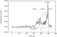
图7为主要波形参数示意图;Figure 7 is a schematic diagram of the main waveform parameters;
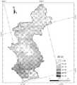
图8为森林冠层高度分布图。Figure 8 is a map of forest canopy height distribution.
具体实施方式Detailed ways
长白山林区是我国重要的森林储备库,是世界上森林景观保存最完整、生长最良好的原始温带森林生态系统之一。下面以位于长白山北坡的吉林省安图县为例进行分析:The Changbai Mountain forest area is an important forest reserve in my country, and it is one of the most complete and best-growing primitive temperate forest ecosystems in the world. Take Antu County, Jilin Province, which is located on the northern slope of Changbai Mountain, as an example for analysis:
步骤一野外样地设置及调查方法
1)两次野外调查样地分布如图1所示。1) The distribution of the two field survey plots is shown in Figure 1.
步骤二多光谱TM数据的获取及专题信息提取Step 2 Acquisition of multispectral TM data and extraction of thematic information
2)基于面向对象分类方法的森林类型信息提取,如图2所示。2) Forest type information extraction based on object-oriented classification method, as shown in Figure 2.
3)叶面积指数遥感估算。基于TM遥感影像6个波段反射率及RVI、NDVI、SLAVI、EVI、VII、MSR、NDVIc、BI、GVI、WI等10个植被指数,并辅助于DEM、ASPECT、SLOPE等地形信息,在相关性分析的基础上,基于偏最小二乘法,构建了各森林类型叶面积指数遥感反演最佳模型,并进行区域扩展,如图3所示:3) Leaf area index remote sensing estimation. Based on the reflectance of 6 bands of TM remote sensing images and 10 vegetation indices such as RVI, NDVI, SLAVI, EVI, VII, MSR, NDVIc, BI, GVI, WI, etc., and supplemented by topographic information such as DEM, ASPECT, and SLOPE, the correlation On the basis of the analysis, based on the partial least squares method, the optimal model for remote sensing retrieval of leaf area index of each forest type was constructed, and the area was expanded, as shown in Figure 3:
4)基于植被指数的像元二分模型对针叶林、阔叶林及针阔混交林郁闭度分别进行遥感反演,结果如图4所示:4) Based on the pixel dichotomy model of the vegetation index, the canopy density of coniferous forest, broad-leaved forest and mixed coniferous and broad-leaved forest was retrieved by remote sensing, and the results are shown in Figure 4:
步骤三基于ICESat/GLAS完整波形数据的森林冠层高度估算Step 3 Estimation of forest canopy height based on ICESat/GLAS complete waveform data
5)激光雷达完整波形数据、相应地理位置及高程信息的提取与标准化。如图5所示为标准化后的波形数据。5) Extraction and standardization of complete waveform data of lidar, corresponding geographic location and elevation information. Figure 5 shows the normalized waveform data.
6)傅里叶变换与低通滤波。6) Fourier transform and low-pass filtering.
图6对比了截止频率为0.125、0.025、0.01对波形数据的平滑效果。随着截止频率的减小,傅里叶变换拟合谐波数量显著减少,虽然平滑效果更好,但是忽略了原始波形数据的细节信息,信号始末位置明显扩展,甚至峰值位置也发生了明显的位移,给波形参数提取及波形长度估算带来严重偏差。Figure 6 compares the smoothing effects of the cut-off frequencies of 0.125, 0.025, and 0.01 on waveform data. As the cut-off frequency decreases, the number of harmonics fitted by Fourier transform is significantly reduced. Although the smoothing effect is better, the details of the original waveform data are ignored. Displacement, which brings serious deviation to waveform parameter extraction and waveform length estimation.
7)噪声估计。7) Noise estimation.
8)信号始末位置判断。8) Judging the start and end positions of the signal.
9)峰值位置的确定。9) Determination of peak position.
Canopy_top为冠层顶部位置;Ground为地面回波位置;Centroid为质心位置;L为波形长度;Signalbeg与Signalend分别为信号始末位置。Canopy_top is the position of the top of the canopy; Ground is the position of the ground echo; Centroid is the position of the centroid; L is the length of the waveform; Signalbeg and Signalend are the beginning and end positions of the signal respectively.
10)平缓地区(坡度<5°)森林冠层高度提取由冠层顶部位置(Canopy_top)与地面回波位置(Ground)之间的波形长度L直接获取。对于例子数据,由公式(2)估算获取的森林冠层高度为28.35m,而野外样地实测高度为28.8m,可见激光雷达获取森林冠层高度的能力还是相当高的。10) Forest canopy height extraction in gentle areas (slope <5°) is directly obtained from the waveform length L between the canopy top position (Canopy_top) and the ground echo position (Ground). For the example data, the forest canopy height estimated by the formula (2) is 28.35m, while the measured height of the field sample plot is 28.8m. It can be seen that the ability of the lidar to obtain the forest canopy height is quite high.
11)坡地条件下,由于仅依靠波形长度很难准确把握森林冠层高度信息,构建了融合波形长度、地形指数与质心位置信息的多元线性回归模型,从而实现复杂地形条件下的GLAS森林冠层高度提取。如表1所示。11) Under slope conditions, it is difficult to accurately grasp the height information of the forest canopy only by the waveform length, so a multiple linear regression model that combines the waveform length, terrain index and centroid position information is constructed to realize the GLAS forest canopy under complex terrain conditions Highly extracted. As shown in Table 1.
各森林类型RMSE以多元线性回归模型为佳,介于2.021~2.674之间,整体而言针阔混交林偏差优于针叶林优于阔叶林。The RMSE of each forest type is best based on the multiple linear regression model, ranging from 2.021 to 2.674. Overall, the deviation of coniferous and broad-leaved mixed forests is better than that of coniferous forests and that of broad-leaved forests.
表1坡地条件下森林冠层高度模型的建立Table 1 Establishment of forest canopy height model under slope conditions

步骤四融合激光雷达冠层高度与多光谱数据进行区域反演Step 4 Fusion lidar canopy height and multispectral data for regional inversion
基于GLAS数据提取的森林冠层高度与TM遥感影像6个波段反射率及其生成的RVI、NDVI、SLAVI、EVI、VII、MSR、NDVIc、BI、GVI、WI等10个植被指数,以及与叶面积指数和冠层郁闭度的相关性,同时考虑地形因素(海拔、坡度、坡向)的影响,基于偏最小二乘法,构建了各森林类型最佳反演模型,并进行空间反演,结果如图8所示。Based on GLAS data extraction, forest canopy height and TM remote sensing image reflectivity of 6 bands and 10 vegetation indices generated such as RVI, NDVI, SLAVI, EVI, VII, MSR, NDVIc, BI, GVI, WI, and leaf Correlation between area index and canopy density, taking into account the influence of terrain factors (elevation, slope, aspect), based on the partial least squares method, the best inversion model for each forest type was constructed, and the spatial inversion was carried out. The result is shown in Figure 8.
在本说明书的描述中,参考术语“一个实施例”、“一些实施例”、“示例”、“具体示例”、或“一些示例”等的描述意指结合该实施例或示例描述的具体特征、结构、材料或者特点包含于本发明的至少一个实施例或示例中。在本说明书中,对上述术语的示意性表述不一定指的是相同的实施例或示例。而且,描述的具体特征、结构、材料或者特点可以在任何的一个或多个实施例或示例中以合适的方式结合。In the description of this specification, descriptions referring to the terms "one embodiment", "some embodiments", "example", "specific examples", or "some examples" mean that specific features described in connection with the embodiment or example , structure, material or characteristic is included in at least one embodiment or example of the present invention. In this specification, schematic representations of the above terms do not necessarily refer to the same embodiment or example. Furthermore, the specific features, structures, materials or characteristics described may be combined in any suitable manner in any one or more embodiments or examples.
尽管已经示出和描述了本发明的实施例,本领域的普通技术人员可以理解:在不脱离本发明的原理和宗旨的情况下可以对这些实施例进行多种变化、修改、替换和变型,本发明的范围由权利要求及其等同物限定。Although the embodiments of the present invention have been shown and described, those skilled in the art can understand that various changes, modifications, substitutions and modifications can be made to these embodiments without departing from the principle and spirit of the present invention. The scope of the invention is defined by the claims and their equivalents.
Claims (4)
Priority Applications (1)
| Application Number | Priority Date | Filing Date | Title |
|---|---|---|---|
| CN201410046762.5ACN103760565A (en) | 2014-02-10 | 2014-02-10 | Regional scale forest canopy height remote sensing retrieval method |
Applications Claiming Priority (1)
| Application Number | Priority Date | Filing Date | Title |
|---|---|---|---|
| CN201410046762.5ACN103760565A (en) | 2014-02-10 | 2014-02-10 | Regional scale forest canopy height remote sensing retrieval method |
Publications (1)
| Publication Number | Publication Date |
|---|---|
| CN103760565Atrue CN103760565A (en) | 2014-04-30 |
Family
ID=50527832
Family Applications (1)
| Application Number | Title | Priority Date | Filing Date |
|---|---|---|---|
| CN201410046762.5APendingCN103760565A (en) | 2014-02-10 | 2014-02-10 | Regional scale forest canopy height remote sensing retrieval method |
Country Status (1)
| Country | Link |
|---|---|
| CN (1) | CN103760565A (en) |
Cited By (26)
| Publication number | Priority date | Publication date | Assignee | Title |
|---|---|---|---|---|
| CN103969645A (en)* | 2014-05-14 | 2014-08-06 | 中国科学院电子学研究所 | Method for measuring tree heights by tomography synthetic aperture radar (SAR) based on compression multi-signal classification (CS-MUSIC) |
| CN104180754A (en)* | 2014-07-28 | 2014-12-03 | 南京林业大学 | Inversion method for biophysical property of forest based on LiDAR comprehensive waveform model |
| CN104462741A (en)* | 2014-09-03 | 2015-03-25 | 中国科学院遥感与数字地球研究所 | City green radiation benefit amount calculation model fused with crown three-dimensional structure |
| CN104615875A (en)* | 2015-01-27 | 2015-05-13 | 中国林业科学研究院资源信息研究所 | Stable regression method for remote sensing individual tree canopy and forest diameter |
| CN104834814A (en)* | 2015-04-29 | 2015-08-12 | 西北师范大学 | Remote sensing image terrain standardization method |
| CN105403876A (en)* | 2015-12-24 | 2016-03-16 | 中国林业科学研究院资源信息研究所 | Measuring method of forest canopy density and device |
| CN105866792A (en)* | 2016-05-31 | 2016-08-17 | 中国科学院遥感与数字地球研究所 | Novel satellite-borne laser radar tree height extraction method |
| CN106198879A (en)* | 2016-07-22 | 2016-12-07 | 广德县时顺竹木有限公司 | A kind of method detecting Cunninghamia lanceolata (Lamb.) Hook. wind resisting stability energy |
| CN106198878A (en)* | 2016-07-22 | 2016-12-07 | 广德县时顺竹木有限公司 | Pinaster Radix Saposhnikoviae grade detection device |
| CN106226472A (en)* | 2016-07-22 | 2016-12-14 | 广德县时顺竹木有限公司 | Cunninghamia lanceolata (Lamb.) Hook. wind resistance prior-warning device |
| CN106248873A (en)* | 2016-07-22 | 2016-12-21 | 广德县时顺竹木有限公司 | A kind of method by detecting measuring apparatus pinaster firmness degree |
| CN106650015A (en)* | 2016-11-24 | 2017-05-10 | 中国科学院东北地理与农业生态研究所 | Landscape scale deduction method of urban forest leaf area index |
| CN107831501A (en)* | 2017-10-27 | 2018-03-23 | 北京林业大学 | A kind of method of ground laser radar simulation angle gauge measure Stand Volume |
| CN108492332A (en)* | 2018-04-03 | 2018-09-04 | 中国林业科学研究院资源信息研究所 | Leaf area index real-time computing technique in a kind of forest three-dimensional scenic |
| CN109583311A (en)* | 2018-10-31 | 2019-04-05 | 中化地质矿山总局地质研究院 | Method and system for evaluating influence of dust around mining area |
| CN110070488A (en)* | 2019-04-25 | 2019-07-30 | 北京工业大学 | A kind of multiple-angle thinking image forest height extracting method based on convolutional neural networks |
| CN111414891A (en)* | 2020-04-07 | 2020-07-14 | 云南电网有限责任公司昆明供电局 | Power transmission line channel tree height inversion method based on laser radar and optical remote sensing |
| CN112649372A (en)* | 2020-11-27 | 2021-04-13 | 中国科学院东北地理与农业生态研究所 | Method for inverting forest canopy density by remote sensing based on machine learning |
| CN113076506A (en)* | 2021-03-23 | 2021-07-06 | 北京师范大学 | Method for regulating and controlling wetland NDVI based on combination of water purification and ecological water conservation |
| CN114037911A (en)* | 2022-01-06 | 2022-02-11 | 武汉大学 | A large-scale remote sensing inversion method of forest height considering ecological zoning |
| CN114296085A (en)* | 2021-12-13 | 2022-04-08 | 中国农业大学 | Crop canopy height measurement calibration method, device, equipment, medium and product |
| CN114626181A (en)* | 2020-12-14 | 2022-06-14 | 中国科学院空天信息创新研究院 | Forest canopy density inversion method based on geometric optical model |
| CN115422309A (en)* | 2022-07-07 | 2022-12-02 | 南京林业大学 | A Neural Network-based Remote Sensing Inversion Method for Large-Scale Stand Age |
| CN117520733A (en)* | 2024-01-05 | 2024-02-06 | 云南师范大学 | Method and system for determining the relationship between forest canopy height and geographical environment covariates |
| WO2024060509A1 (en)* | 2022-09-23 | 2024-03-28 | 四川大学 | Forest stand canopy density measurement method |
| CN119415804A (en)* | 2024-11-07 | 2025-02-11 | 桂林理工大学 | Forest canopy height estimation method, device, system, and storage medium |
Citations (4)
| Publication number | Priority date | Publication date | Assignee | Title |
|---|---|---|---|---|
| US5886662A (en)* | 1997-06-18 | 1999-03-23 | Zai Amelex | Method and apparatus for remote measurement of terrestrial biomass |
| WO2011123252A1 (en)* | 2010-03-30 | 2011-10-06 | Weyerhaeuser Nr Company | System and method for identifying individual trees in lidar data using local view |
| CN102401898A (en)* | 2011-08-25 | 2012-04-04 | 北京理工大学 | Quantified simulation method for forest remote sensing data of synthetic aperture radar |
| CN103323846A (en)* | 2013-05-15 | 2013-09-25 | 中国科学院电子学研究所 | Inversion method based on polarization interference synthetic aperture radar and device |
- 2014
- 2014-02-10CNCN201410046762.5Apatent/CN103760565A/enactivePending
Patent Citations (4)
| Publication number | Priority date | Publication date | Assignee | Title |
|---|---|---|---|---|
| US5886662A (en)* | 1997-06-18 | 1999-03-23 | Zai Amelex | Method and apparatus for remote measurement of terrestrial biomass |
| WO2011123252A1 (en)* | 2010-03-30 | 2011-10-06 | Weyerhaeuser Nr Company | System and method for identifying individual trees in lidar data using local view |
| CN102401898A (en)* | 2011-08-25 | 2012-04-04 | 北京理工大学 | Quantified simulation method for forest remote sensing data of synthetic aperture radar |
| CN103323846A (en)* | 2013-05-15 | 2013-09-25 | 中国科学院电子学研究所 | Inversion method based on polarization interference synthetic aperture radar and device |
Non-Patent Citations (2)
| Title |
|---|
| 刘清旺等: "利用机载激光雷达数据提取单株木树高和树冠", 《北京林业大学学报》, vol. 30, no. 6, 30 November 2008 (2008-11-30), pages 83 - 89* |
| 汤旭光: "基于激光雷达与多光谱遥感数据的森林地上生物量反演研究", 《中国博士学位论文全文数据库农业科技辑》, no. 10, 15 October 2013 (2013-10-15), pages 1 - 92* |
Cited By (42)
| Publication number | Priority date | Publication date | Assignee | Title |
|---|---|---|---|---|
| CN103969645A (en)* | 2014-05-14 | 2014-08-06 | 中国科学院电子学研究所 | Method for measuring tree heights by tomography synthetic aperture radar (SAR) based on compression multi-signal classification (CS-MUSIC) |
| CN104180754A (en)* | 2014-07-28 | 2014-12-03 | 南京林业大学 | Inversion method for biophysical property of forest based on LiDAR comprehensive waveform model |
| CN104180754B (en)* | 2014-07-28 | 2017-02-01 | 南京林业大学 | Inversion method for biophysical property of forest based on LiDAR comprehensive waveform model |
| CN104462741A (en)* | 2014-09-03 | 2015-03-25 | 中国科学院遥感与数字地球研究所 | City green radiation benefit amount calculation model fused with crown three-dimensional structure |
| CN104462741B (en)* | 2014-09-03 | 2018-10-30 | 中国科学院遥感与数字地球研究所 | A kind of construction method of the benefited amount computation model of city green radiation of fusion tree crown three-dimensional structure |
| CN104615875A (en)* | 2015-01-27 | 2015-05-13 | 中国林业科学研究院资源信息研究所 | Stable regression method for remote sensing individual tree canopy and forest diameter |
| CN104615875B (en)* | 2015-01-27 | 2017-07-04 | 中国林业科学研究院资源信息研究所 | A kind of sane remote sensing list wood hat width and forest diameter homing method |
| CN104834814A (en)* | 2015-04-29 | 2015-08-12 | 西北师范大学 | Remote sensing image terrain standardization method |
| CN104834814B (en)* | 2015-04-29 | 2018-04-10 | 西北师范大学 | Remote sensing image landform standardized method |
| CN105403876A (en)* | 2015-12-24 | 2016-03-16 | 中国林业科学研究院资源信息研究所 | Measuring method of forest canopy density and device |
| CN105403876B (en)* | 2015-12-24 | 2018-01-30 | 中国林业科学研究院资源信息研究所 | The measuring method and device of forest canopy density |
| CN105866792A (en)* | 2016-05-31 | 2016-08-17 | 中国科学院遥感与数字地球研究所 | Novel satellite-borne laser radar tree height extraction method |
| CN105866792B (en)* | 2016-05-31 | 2019-04-26 | 中国科学院遥感与数字地球研究所 | A method for tree height extraction of spaceborne lidar |
| CN106226472B (en)* | 2016-07-22 | 2018-11-02 | 泉州市泉港区鑫悦盟工业科技有限公司 | Chinese fir wind resistance prior-warning device |
| CN106248873A (en)* | 2016-07-22 | 2016-12-21 | 广德县时顺竹木有限公司 | A kind of method by detecting measuring apparatus pinaster firmness degree |
| CN106226472A (en)* | 2016-07-22 | 2016-12-14 | 广德县时顺竹木有限公司 | Cunninghamia lanceolata (Lamb.) Hook. wind resistance prior-warning device |
| CN106198878B (en)* | 2016-07-22 | 2018-11-02 | 泉州市泉港区鑫悦盟工业科技有限公司 | The windproof grade detection device of pine tree |
| CN106198878A (en)* | 2016-07-22 | 2016-12-07 | 广德县时顺竹木有限公司 | Pinaster Radix Saposhnikoviae grade detection device |
| CN106198879B (en)* | 2016-07-22 | 2018-11-16 | 广东双木林科技有限公司 | A method of detection Chinese fir wind resisting stability can |
| CN106198879A (en)* | 2016-07-22 | 2016-12-07 | 广德县时顺竹木有限公司 | A kind of method detecting Cunninghamia lanceolata (Lamb.) Hook. wind resisting stability energy |
| CN106650015A (en)* | 2016-11-24 | 2017-05-10 | 中国科学院东北地理与农业生态研究所 | Landscape scale deduction method of urban forest leaf area index |
| CN107831501A (en)* | 2017-10-27 | 2018-03-23 | 北京林业大学 | A kind of method of ground laser radar simulation angle gauge measure Stand Volume |
| CN108492332B (en)* | 2018-04-03 | 2021-05-18 | 中国林业科学研究院资源信息研究所 | Real-time calculation method for leaf area index in forest three-dimensional scene |
| CN108492332A (en)* | 2018-04-03 | 2018-09-04 | 中国林业科学研究院资源信息研究所 | Leaf area index real-time computing technique in a kind of forest three-dimensional scenic |
| CN109583311A (en)* | 2018-10-31 | 2019-04-05 | 中化地质矿山总局地质研究院 | Method and system for evaluating influence of dust around mining area |
| CN110070488A (en)* | 2019-04-25 | 2019-07-30 | 北京工业大学 | A kind of multiple-angle thinking image forest height extracting method based on convolutional neural networks |
| CN110070488B (en)* | 2019-04-25 | 2023-01-03 | 北京工业大学 | Multi-angle remote sensing image forest height extraction method based on convolutional neural network |
| CN111414891A (en)* | 2020-04-07 | 2020-07-14 | 云南电网有限责任公司昆明供电局 | Power transmission line channel tree height inversion method based on laser radar and optical remote sensing |
| CN111414891B (en)* | 2020-04-07 | 2023-04-14 | 云南电网有限责任公司昆明供电局 | Tree height retrieval method for transmission line channels based on lidar and optical remote sensing |
| CN112649372A (en)* | 2020-11-27 | 2021-04-13 | 中国科学院东北地理与农业生态研究所 | Method for inverting forest canopy density by remote sensing based on machine learning |
| CN114626181B (en)* | 2020-12-14 | 2025-04-15 | 中国科学院空天信息创新研究院 | A forest canopy density inversion method based on geometric optical model |
| CN114626181A (en)* | 2020-12-14 | 2022-06-14 | 中国科学院空天信息创新研究院 | Forest canopy density inversion method based on geometric optical model |
| CN113076506A (en)* | 2021-03-23 | 2021-07-06 | 北京师范大学 | Method for regulating and controlling wetland NDVI based on combination of water purification and ecological water conservation |
| CN113076506B (en)* | 2021-03-23 | 2023-06-09 | 北京师范大学 | Method for regulating and controlling wetland NDVI (non-uniform dry concentration) based on combination of water quality purification and ecological water conservation |
| CN114296085A (en)* | 2021-12-13 | 2022-04-08 | 中国农业大学 | Crop canopy height measurement calibration method, device, equipment, medium and product |
| CN114037911A (en)* | 2022-01-06 | 2022-02-11 | 武汉大学 | A large-scale remote sensing inversion method of forest height considering ecological zoning |
| CN115422309A (en)* | 2022-07-07 | 2022-12-02 | 南京林业大学 | A Neural Network-based Remote Sensing Inversion Method for Large-Scale Stand Age |
| CN115422309B (en)* | 2022-07-07 | 2023-05-23 | 南京林业大学 | A Neural Network-Based Large-Scale Forest Age Remote Sensing Inversion Method |
| WO2024060509A1 (en)* | 2022-09-23 | 2024-03-28 | 四川大学 | Forest stand canopy density measurement method |
| CN117520733A (en)* | 2024-01-05 | 2024-02-06 | 云南师范大学 | Method and system for determining the relationship between forest canopy height and geographical environment covariates |
| CN117520733B (en)* | 2024-01-05 | 2024-03-19 | 云南师范大学 | Forest canopy height and geographic environment covariate relation determination method and system |
| CN119415804A (en)* | 2024-11-07 | 2025-02-11 | 桂林理工大学 | Forest canopy height estimation method, device, system, and storage medium |
Similar Documents
| Publication | Publication Date | Title |
|---|---|---|
| CN103760565A (en) | Regional scale forest canopy height remote sensing retrieval method | |
| White et al. | Comparison of airborne laser scanning and digital stereo imagery for characterizing forest canopy gaps in coastal temperate rainforests | |
| Lin et al. | Estimating aboveground biomass of urban forest trees with dual-source UAV acquired point clouds | |
| Nurminen et al. | Performance of dense digital surface models based on image matching in the estimation of plot-level forest variables | |
| CN109919875B (en) | A feature-assisted residential area extraction and classification method based on high time-frequency remote sensing images | |
| CN111709981A (en) | A registration method of laser point cloud and simulated image based on feature line fusion | |
| CN104656098A (en) | Method for inverting remote sensing forest biomass | |
| CN109840553A (en) | Method and system, storage medium, and electronic device for extracting types of cultivated crops | |
| Zhang et al. | Efficient registration of terrestrial LiDAR scans using a coarse-to-fine strategy for forestry applications | |
| CN110221311A (en) | The high method of high close-stand tree is extracted based on TLS and UAV automation | |
| CN107832681A (en) | The high evaluation method of forest list ebon of joint LiDAR point cloud and synchronous remote sensing image | |
| CN107036968B (en) | A method for real-time monitoring of soil moisture | |
| CN112668534B (en) | Forest zone vegetation height inversion method based on digital orthographic images and digital surface models | |
| CN103398957A (en) | Hyperspectrum and laser radar-based method for extracting vertical distribution of leaf area | |
| Tao et al. | Mapping tropical forest trees across large areas with lightweight cost-effective terrestrial laser scanning | |
| CN112014542B (en) | Vegetation coverage area soil moisture map manufacturing method, device, storage medium and equipment | |
| CN111046613A (en) | Optimal river channel calculation method based on path tracing and river network extraction method based on multi-temporal remote sensing images | |
| CN109427091A (en) | A kind of Biomass Models based on high-spectrum remote-sensing and photogrammetric technology grind construction method | |
| Smits et al. | Individual tree identification using different LIDAR and optical imagery data processing methods | |
| Hu et al. | Dynamic monitoring of land subsidence in mining area from multi-source remote-sensing data–a case study at Yanzhou, China | |
| CN104951754A (en) | Sophisticated crop classifying method based on combination of object oriented technology and NDVI (normalized difference vegetation index) time series | |
| Xi et al. | Quantifying understory vegetation density using multi-temporal Sentinel-2 and GEDI LiDAR data | |
| Sun et al. | Feasibility study on the estimation of the living vegetation volume of individual street trees using terrestrial laser scanning | |
| CN109146951A (en) | A method of ginkgo artificial forest leaf area index is estimated based on unmanned plane laser radar porosity model | |
| Sun et al. | Retrieval and accuracy assessment of tree and stand parameters for Chinese fir plantation using terrestrial laser scanning |
Legal Events
| Date | Code | Title | Description |
|---|---|---|---|
| C06 | Publication | ||
| PB01 | Publication | ||
| C10 | Entry into substantive examination | ||
| SE01 | Entry into force of request for substantive examination | ||
| C02 | Deemed withdrawal of patent application after publication (patent law 2001) | ||
| WD01 | Invention patent application deemed withdrawn after publication | Application publication date:20140430 |