CN103632538A - Three-dimensional (3D) live-action collection system for road - Google Patents
Three-dimensional (3D) live-action collection system for roadDownload PDFInfo
- Publication number
- CN103632538A CN103632538ACN201310692606.1ACN201310692606ACN103632538ACN 103632538 ACN103632538 ACN 103632538ACN 201310692606 ACN201310692606 ACN 201310692606ACN 103632538 ACN103632538 ACN 103632538A
- Authority
- CN
- China
- Prior art keywords
- data
- road
- real
- satellite positioning
- processing platform
- Prior art date
- Legal status (The legal status is an assumption and is not a legal conclusion. Google has not performed a legal analysis and makes no representation as to the accuracy of the status listed.)
- Pending
Links
- 238000012545processingMethods0.000claimsabstractdescription22
- 238000001514detection methodMethods0.000claimsabstractdescription13
- 238000004364calculation methodMethods0.000claimsabstractdescription12
- 238000005516engineering processMethods0.000claimsdescription13
- 238000005259measurementMethods0.000claims1
- 230000007547defectEffects0.000abstract1
- 238000007726management methodMethods0.000description9
- 238000011160researchMethods0.000description4
- 238000000034methodMethods0.000description3
- 230000009286beneficial effectEffects0.000description2
- 238000010276constructionMethods0.000description2
- 238000011161developmentMethods0.000description2
- 239000007787solidSubstances0.000description2
- 238000004458analytical methodMethods0.000description1
- 238000004891communicationMethods0.000description1
- 238000013480data collectionMethods0.000description1
- 238000013461designMethods0.000description1
- 238000010586diagramMethods0.000description1
- 238000000605extractionMethods0.000description1
- 230000010354integrationEffects0.000description1
- 238000004519manufacturing processMethods0.000description1
- 230000000149penetrating effectEffects0.000description1
- 239000013589supplementSubstances0.000description1
- 230000001360synchronised effectEffects0.000description1
- 238000012800visualizationMethods0.000description1
Images

Landscapes
- Traffic Control Systems (AREA)
- Image Processing (AREA)
Abstract
Translated fromChinese
Description
Translated fromChinese技术领域technical field
本发明属于城市道路交通3D建模技术领域,涉及一种道路3D实景采集系统。The invention belongs to the technical field of urban road traffic 3D modeling, and relates to a road 3D real-scene collection system.
背景技术Background technique
随着计算机技术和信息技术的飞速发展,城市信息化的程度越来越高,信息技术正全方位地渗入城市规划领域中,而“数字地球”(Digital Earth)、“数字城市”(Digital City)概念的提出和相关技术的逐步完善,也使得城市规划设计的技术手段越来越丰富,道路3D实景采集系统是3D-GIS研究的一部分,该系统的研究、建立与应用是目前GIS学科的热点之一,在数字城市、自然资源管理、城市规划、交通等应用领域显示出重要的价值和巨大的潜力。With the rapid development of computer technology and information technology, the degree of urban informatization is getting higher and higher, and information technology is penetrating into the field of urban planning in an all-round way. ) concept and the gradual improvement of related technologies have also enriched the technical means of urban planning and design. The road 3D real-scene acquisition system is a part of 3D-GIS research. The research, establishment and application of this system are the current GIS subject. One of the hotspots, it has shown important value and great potential in digital cities, natural resource management, urban planning, transportation and other application fields.
道路3D实景采集系统是建立数字城市的基础和重点,是智能交通系统ITS领域的一个研究热点。人们正在通过各种各样的途径进行城市建模,而且已经取得非常重要的进展。由于我国数字城市建设起步较晚,在我国,城市GIS系统正从二维GIS向三维GIS发展,通讯基础设施的进展速度比较快,政府和企业内部信息系统建设的进展比较慢,数字城市的综合集成还处在低级阶段。道路3D实景采集技术是实现道路三维GIS系统的关键技术。道路3D实景采集系统是指能对道路(包括城市道路、高速公路、等级公路等)某区域内空间对象进行三维数据的采集和分析,是建立三维GIS系统的基础。Road 3D real-scene acquisition system is the basis and focus of establishing digital city, and it is a research hotspot in the field of intelligent transportation system ITS. People are doing urban modeling in various ways, and very important progress has been made. Due to the late start of digital city construction in my country, the urban GIS system is developing from two-dimensional GIS to three-dimensional GIS in my country, the progress of communication infrastructure is relatively fast, and the progress of government and enterprise internal information system construction is relatively slow. Integration is still in its infancy. Road 3D real scene acquisition technology is the key technology to realize road 3D GIS system. Road 3D real scene collection system refers to the collection and analysis of three-dimensional data of spatial objects in a certain area of roads (including urban roads, expressways, graded roads, etc.), and is the basis for establishing a three-dimensional GIS system.
近年来,国内外许多学者已经在道路3D实景采集方面做了很多研究,也得到了丰硕的成果。这在很大程度上推动了三维实景采集、可视化等技术在城市管理、高速公路管理,公路应急指挥,出行服务等领域的应用发展。但是,目前在复杂建筑物建模、真实纹理提取、实景连续采集等方面还有些问题急待解决,且大多数的3D采集系统都结构复杂、价格高昂,难以在国内推广。In recent years, many scholars at home and abroad have done a lot of research on road 3D real scene acquisition, and have also obtained fruitful results. This has largely promoted the application and development of 3D real scene acquisition and visualization technologies in urban management, highway management, highway emergency command, travel services and other fields. However, there are still some problems to be solved in the aspects of complex building modeling, real texture extraction, real scene continuous acquisition, etc., and most of the 3D acquisition systems have complex structures and high prices, which are difficult to promote in China.
发明内容Contents of the invention
有鉴于此,本发明的目的在于提供一种道路3D实景采集系统,该系统通过全景摄像机、卫星定位系统和惯量姿态检测装置同步进行各项数据采集,将采集到的数据传送至数据处理平台,数据处理平台根据采集到的数据进行处理并建立3D模型,实现对影像数据中的道路交通设施、建筑物等进行精确的三维实体建模。In view of this, the object of the present invention is to provide a road 3D real-scene acquisition system, which synchronously collects various data through a panoramic camera, a satellite positioning system and an inertia attitude detection device, and transmits the collected data to a data processing platform, The data processing platform processes the collected data and establishes a 3D model to realize accurate 3D solid modeling of road traffic facilities and buildings in the image data.
为达到上述目的,本发明提供如下技术方案:To achieve the above object, the present invention provides the following technical solutions:
一种道路3D实景采集系统,安装于一台采集车内,包括全景摄像机、卫星定位系统、惯量姿态检测装置和数据处理平台;全景摄像机、卫星定位系统、惯量姿态检测装置同步采集道路环境图像数据、空间位置数据和车辆姿态数据,并将采集到的数据传送至数据处理平台;数据处理平台接收到同步传送的各项数据,并通过其上的三维坐标解算模块和三维对象编辑与管理模块实现坐标解算、3D图像建立以及3D模型应用。A road 3D real scene collection system installed in a collection vehicle, including a panoramic camera, a satellite positioning system, an inertia attitude detection device and a data processing platform; the panoramic camera, a satellite positioning system, and an inertia attitude detection device synchronously collect road environment image data , spatial position data and vehicle attitude data, and transmit the collected data to the data processing platform; the data processing platform receives the synchronously transmitted data, and uses the 3D coordinate calculation module and 3D object editing and management module on it Realize coordinate calculation, 3D image creation and 3D model application.
进一步,数据处理平台上的三维坐标解算模块利用相机矢量CV技术对每帧图像数据中的每一个像素解算其三维相对坐标和绝对坐标,与影像数据建立索引保存到数据库中,并根据相邻帧间特征点数据构成没有盲点的完整三维图像。Further, the 3D coordinate calculation module on the data processing platform uses the camera vector CV technology to calculate the 3D relative and absolute coordinates of each pixel in each frame of image data, establishes an index with the image data and saves it in the database, and The feature point data between adjacent frames constitute a complete three-dimensional image without blind spots.
进一步,所述三维对象编辑与管理模块用于实现对三维图像模型的管理和应用,包括:在模型上360度全方位查看道路周围景物、实时影像数据中点线面的跟踪与3D坐标的显示、量测任意两点间的距离、任意区域的面积和垂直高度以及3DCG的载入与导出。Further, the 3D object editing and management module is used to realize the management and application of the 3D image model, including: 360-degree viewing of the scenery around the road on the model, tracking of points, lines and planes in real-time image data, and display of 3D coordinates , Measure the distance between any two points, the area and vertical height of any area, and load and export 3DCG.
进一步,所述卫星定位系统采用北斗卫星定位系统。Further, the satellite positioning system adopts the Beidou satellite positioning system.
进一步,所述卫星定位系统采用GPS卫星定位系统。Further, the satellite positioning system adopts GPS satellite positioning system.
进一步,所述GPS卫星定位系统采用1块GPS模块。Further, the GPS satellite positioning system adopts one GPS module.
进一步,所述数据处理平台采用具有固体硬盘的车载计算机。固体硬盘速度快,且抗震性能好,非常适合于应用于车载计算机。Further, the data processing platform adopts a vehicle-mounted computer with a solid-state hard disk. The solid-state hard disk is fast and has good anti-seismic performance, which is very suitable for being applied to the vehicle-mounted computer.
本发明的有益效果在于:本发明提供的道路3D实景采集系统结构简单,制造成本较低,能够方便快速的对城市道路环境进行3D实景采集,并建立三维模型,从而实现城市道路交通环境的三维模型管理和应用,有效弥补了现有道路实景采集系统缺乏实景三维数据的缺陷,同时也是对传统卫星/航测影响和人工单点数据采集技术之间的有效补充。The beneficial effects of the present invention are: the road 3D real-scene collection system provided by the present invention has simple structure and low manufacturing cost, and can conveniently and quickly carry out 3D real-scene collection on the urban road environment and establish a three-dimensional model, thereby realizing the three-dimensional urban road traffic environment Model management and application effectively make up for the lack of real 3D data in the existing road real scene collection system, and are also an effective supplement to traditional satellite/aerial survey impact and manual single point data collection technology.
附图说明Description of drawings
为了使本发明的目的、技术方案和有益效果更加清楚,本发明提供如下附图进行说明:In order to make the purpose, technical scheme and beneficial effect of the present invention clearer, the present invention provides the following drawings for illustration:
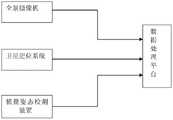
图1为本系统的结构示意图;Fig. 1 is the structural representation of this system;
图2为本系统的工作流程图。Figure 2 is the working flow chart of the system.
具体实施方式Detailed ways
下面将结合附图,对本发明的优选实施例进行详细的描述。The preferred embodiments of the present invention will be described in detail below with reference to the accompanying drawings.
图1为本系统的结构示意图,如图所示,本系统包括全景摄像机、卫星定位系统、惯量姿态检测装置和数据处理平台;全景摄像机、卫星定位系统、惯量姿态检测装置分别与数据处理平台相连;全景摄像机、卫星定位系统、惯量姿态检测装置同步采集道路环境图像数据、空间位置数据和车辆姿态数据,并将采集到的数据传送至数据处理平台;数据处理平台接收到同步传送的各项数据,并通过其上的三维坐标解算模块和三维对象编辑与管理模块实现坐标解算、3D图像建立以及3D模型应用。上述设备都安装在一台采集车内。Figure 1 is a schematic structural diagram of the system. As shown in the figure, the system includes a panoramic camera, a satellite positioning system, an inertia attitude detection device and a data processing platform; the panoramic camera, a satellite positioning system, and an inertia attitude detection device are respectively connected to the data processing platform ;Panoramic camera, satellite positioning system, and inertia attitude detection device synchronously collect road environment image data, spatial position data and vehicle attitude data, and transmit the collected data to the data processing platform; the data processing platform receives the synchronously transmitted data , and realize coordinate calculation, 3D image creation and 3D model application through the 3D coordinate calculation module and 3D object editing and management module on it. The above-mentioned equipment is all installed in a collection vehicle.
在本实施例中,卫星定位系统采用但不限于GPS卫星定位系统,其中采用1块GPS模块。当需要进行道路环境的3D实景采集时,工作人员将采集车行驶在道路上,车速控制在30~50km/h之内,开启系统,系统将自动对数据进行采集。In this embodiment, the satellite positioning system adopts but is not limited to the GPS satellite positioning system, wherein one GPS module is used. When it is necessary to collect 3D real scenes of the road environment, the staff will drive the collection vehicle on the road, control the speed of the vehicle within 30-50km/h, turn on the system, and the system will automatically collect the data.
图2为本系统的工作流程图,如图所示,本系统的具体工作流程为:当需要对道路环境进行3D实景采集时,工作人员将采集车驾驶在需要采集的道路上,保持30~50km/h的车速并开启系统。当系统开启后,全景摄像机开始工作,并对道路环境进行360度全景影像的录入,这种影像的录入,相对于普通相机全景摄像机录入的画面是没有盲点存在的;同时,卫星定位系统GPS采集空间位置数据,惯量姿态检测装置IMU采集车辆姿态数据,卫星定位系统、惯量姿态检测装置和全景摄像机在采集数据的时候采用时间同步技术。当全景摄像机、卫星定位系统和惯量姿态检测装置采集到同步数据后,各数据被传送至数据处理平台,在本实施例中,数据处理平台采用具有固体硬盘的车载计算机;数据处理平台接收到上述原始数据以后对数据进行分析处理,其中,数据处理平台上的三维坐标解算模块会根据接收到的数据进行坐标解算,进而建立道路环境的三维模型。Figure 2 is the working flow chart of this system. As shown in the figure, the specific working process of this system is: when it is necessary to collect 3D real scene of the road environment, the staff will drive the collection vehicle on the road to be collected, and keep it for 30~ 50km/h and turn on the system. When the system is turned on, the panoramic camera starts to work and records 360-degree panoramic images of the road environment. Compared with the pictures recorded by ordinary cameras, panoramic cameras have no blind spots; at the same time, the satellite positioning system GPS collects Space position data, inertial attitude detection device IMU collects vehicle attitude data, satellite positioning system, inertial attitude detection device and panoramic camera adopt time synchronization technology when collecting data. After the synchronous data is collected by the panoramic camera, the satellite positioning system and the inertia attitude detection device, each data is transmitted to the data processing platform. In this embodiment, the data processing platform adopts a vehicle-mounted computer with a solid hard disk; The raw data is then analyzed and processed. The 3D coordinate calculation module on the data processing platform will perform coordinate calculation based on the received data, and then establish a 3D model of the road environment.
在本实施例中,三维坐标解算模块利用相机矢量CV技术对每帧图像数据中的每一个像素解算其三维相对坐标和绝对坐标,与影像数据建立索引保存到数据库中,同时,根据相邻帧间特征点数据构成没有盲点的完整三维图像。CV(Camera Vector,相机矢量)技术就是利用来自相机中心的矢量(包含位置和方位信息),给每一祯的每一个像素分配准确的3D坐标,一个CV值表示一帧图像所处的3D位置和姿态;自动抽取全景影像中的特征点,通过这些点之间的相对关系,计算CV值,然后通过IMU来确定CV值在实际坐标系中的位置,从而得到全景影像中每个像素点的实际坐标。In this embodiment, the three-dimensional coordinate calculation module uses the camera vector CV technology to calculate the three-dimensional relative coordinates and absolute coordinates of each pixel in each frame of image data, and establishes an index with the image data and saves it in the database. The feature point data between adjacent frames constitute a complete three-dimensional image without blind spots. CV (Camera Vector, camera vector) technology is to use the vector from the center of the camera (including position and orientation information) to assign accurate 3D coordinates to each pixel of each frame, and a CV value represents the 3D position of a frame image and posture; automatically extract the feature points in the panoramic image, calculate the CV value through the relative relationship between these points, and then use the IMU to determine the position of the CV value in the actual coordinate system, so as to obtain the position of each pixel in the panoramic image actual coordinates.
在得到道路环境的三维模型以后可以通过系统对模型进行管理和应用,满足人们的数字化城市系统管理需求。具体来说,在通过本系统得到道路环境三维模型以后,使用者可以在模型上360度全方位查看道路周围景物、实时影像数据中点线面的跟踪与3D坐标的显示、量测任意两点间的距离、任意区域的面积和垂直高度以及3DCG的载入与导出。After obtaining the 3D model of the road environment, the model can be managed and applied through the system to meet people's digital city system management needs. Specifically, after obtaining the 3D model of the road environment through this system, the user can view the surrounding scenery of the road in a 360-degree manner on the model, track the points, lines and planes in the real-time image data, display the 3D coordinates, and measure any two points The distance between them, the area and vertical height of any area, and the loading and exporting of 3DCG.
最后说明的是,以上优选实施例仅用以说明本发明的技术方案而非限制,尽管通过上述优选实施例已经对本发明进行了详细的描述,但本领域技术人员应当理解,可以在形式上和细节上对其作出各种各样的改变,而不偏离本发明权利要求书所限定的范围。Finally, it should be noted that the above preferred embodiments are only used to illustrate the technical solutions of the present invention and not to limit them. Although the present invention has been described in detail through the above preferred embodiments, those skilled in the art should understand that it can be described in terms of form and Various changes may be made in the details without departing from the scope of the invention defined by the claims.
Claims (7)
Translated fromChinesePriority Applications (1)
| Application Number | Priority Date | Filing Date | Title |
|---|---|---|---|
| CN201310692606.1ACN103632538A (en) | 2013-12-17 | 2013-12-17 | Three-dimensional (3D) live-action collection system for road |
Applications Claiming Priority (1)
| Application Number | Priority Date | Filing Date | Title |
|---|---|---|---|
| CN201310692606.1ACN103632538A (en) | 2013-12-17 | 2013-12-17 | Three-dimensional (3D) live-action collection system for road |
Publications (1)
| Publication Number | Publication Date |
|---|---|
| CN103632538Atrue CN103632538A (en) | 2014-03-12 |
Family
ID=50213534
Family Applications (1)
| Application Number | Title | Priority Date | Filing Date |
|---|---|---|---|
| CN201310692606.1APendingCN103632538A (en) | 2013-12-17 | 2013-12-17 | Three-dimensional (3D) live-action collection system for road |
Country Status (1)
| Country | Link |
|---|---|
| CN (1) | CN103632538A (en) |
Cited By (8)
| Publication number | Priority date | Publication date | Assignee | Title |
|---|---|---|---|---|
| CN104301673A (en)* | 2014-09-28 | 2015-01-21 | 北京正安融翰技术有限公司 | Real-time traffic flow analysis and panoramic visualization method based on video analysis |
| CN104504904A (en)* | 2015-01-08 | 2015-04-08 | 杭州智诚惠通科技有限公司 | Mobile acquisition method of transportation facility |
| CN104729485A (en)* | 2015-03-03 | 2015-06-24 | 北京空间机电研究所 | Visual positioning method based on vehicle-mounted panorama image and streetscape matching |
| CN105427378A (en)* | 2015-11-06 | 2016-03-23 | 武汉东湖学院 | Digital multimedia technology based cultural old city display method and system |
| CN105788235A (en)* | 2014-12-22 | 2016-07-20 | 中交宇科(北京)空间信息技术有限公司 | Internet of things-based highway three-dimensional adaptive intelligent control system and method |
| CN107024207A (en)* | 2017-04-17 | 2017-08-08 | 武汉众睿科技发展股份有限公司 | A kind of zonule map navigation system |
| CN107547792A (en)* | 2016-06-29 | 2018-01-05 | 常州市测绘院 | A vehicle-mounted mobile image acquisition system and its working method for 3D modeling |
| CN115307544A (en)* | 2022-08-15 | 2022-11-08 | 淄博市交通建设发展中心 | Road slope pavement distance measuring system and method |
Citations (4)
| Publication number | Priority date | Publication date | Assignee | Title |
|---|---|---|---|---|
| CN201570065U (en)* | 2009-12-24 | 2010-09-01 | 浙江大学城市学院 | Live-action panorama acquisition device based on GPS |
| CN202782968U (en)* | 2012-09-21 | 2013-03-13 | 纵横皆景(武汉)信息技术有限公司 | Vehicle-mounted measure integrated system based on laser scanning and panorama images |
| CN203148438U (en)* | 2013-03-08 | 2013-08-21 | 武汉海达数云技术有限公司 | Integrated mobile three-dimensional measuring device |
| CN103303183A (en)* | 2013-07-03 | 2013-09-18 | 国家电网公司 | Three-dimensional data collection vehicle for structuring three-dimensional digital power grid for power transmission and transformation and control method |
- 2013
- 2013-12-17CNCN201310692606.1Apatent/CN103632538A/enactivePending
Patent Citations (4)
| Publication number | Priority date | Publication date | Assignee | Title |
|---|---|---|---|---|
| CN201570065U (en)* | 2009-12-24 | 2010-09-01 | 浙江大学城市学院 | Live-action panorama acquisition device based on GPS |
| CN202782968U (en)* | 2012-09-21 | 2013-03-13 | 纵横皆景(武汉)信息技术有限公司 | Vehicle-mounted measure integrated system based on laser scanning and panorama images |
| CN203148438U (en)* | 2013-03-08 | 2013-08-21 | 武汉海达数云技术有限公司 | Integrated mobile three-dimensional measuring device |
| CN103303183A (en)* | 2013-07-03 | 2013-09-18 | 国家电网公司 | Three-dimensional data collection vehicle for structuring three-dimensional digital power grid for power transmission and transformation and control method |
Non-Patent Citations (1)
| Title |
|---|
| 刘继平等: "IMMS(移动实景测图系统)在三维数字电网构建中的应用", 《勘察科学技术》, no. 5, 20 October 2013 (2013-10-20), pages 45 - 49* |
Cited By (12)
| Publication number | Priority date | Publication date | Assignee | Title |
|---|---|---|---|---|
| CN104301673A (en)* | 2014-09-28 | 2015-01-21 | 北京正安融翰技术有限公司 | Real-time traffic flow analysis and panoramic visualization method based on video analysis |
| CN104301673B (en)* | 2014-09-28 | 2017-09-05 | 北京正安维视科技股份有限公司 | A kind of real-time traffic analysis and panorama visual method based on video analysis |
| CN105788235A (en)* | 2014-12-22 | 2016-07-20 | 中交宇科(北京)空间信息技术有限公司 | Internet of things-based highway three-dimensional adaptive intelligent control system and method |
| CN104504904A (en)* | 2015-01-08 | 2015-04-08 | 杭州智诚惠通科技有限公司 | Mobile acquisition method of transportation facility |
| CN104729485A (en)* | 2015-03-03 | 2015-06-24 | 北京空间机电研究所 | Visual positioning method based on vehicle-mounted panorama image and streetscape matching |
| CN104729485B (en)* | 2015-03-03 | 2016-11-30 | 北京空间机电研究所 | A kind of vision positioning method based on vehicle-mounted panoramic image Yu streetscape map match |
| CN105427378A (en)* | 2015-11-06 | 2016-03-23 | 武汉东湖学院 | Digital multimedia technology based cultural old city display method and system |
| CN105427378B (en)* | 2015-11-06 | 2018-01-30 | 武汉东湖学院 | Cultural city methods of exhibiting and system based on Digital object identifier |
| CN107547792A (en)* | 2016-06-29 | 2018-01-05 | 常州市测绘院 | A vehicle-mounted mobile image acquisition system and its working method for 3D modeling |
| CN107547792B (en)* | 2016-06-29 | 2020-02-14 | 常州市测绘院 | Vehicle-mounted mobile image acquisition system |
| CN107024207A (en)* | 2017-04-17 | 2017-08-08 | 武汉众睿科技发展股份有限公司 | A kind of zonule map navigation system |
| CN115307544A (en)* | 2022-08-15 | 2022-11-08 | 淄博市交通建设发展中心 | Road slope pavement distance measuring system and method |
Similar Documents
| Publication | Publication Date | Title |
|---|---|---|
| CN103632538A (en) | Three-dimensional (3D) live-action collection system for road | |
| CN113936108B (en) | A drone shooting and reconstruction method and device for fine modeling of building facades | |
| CN110222137B (en) | Intelligent campus system based on oblique photography and augmented reality technology | |
| CN105096386B (en) | A wide range of complicated urban environment geometry map automatic generation method | |
| CN108388995B (en) | Method and system for establishing road asset management system | |
| CN101951502B (en) | Three-dimensional intelligent video monitoring method | |
| WO2021121306A1 (en) | Visual location method and system | |
| CN110648389A (en) | 3D reconstruction method and system for city street view based on cooperation of unmanned aerial vehicle and edge vehicle | |
| CN101329771B (en) | A Fast Modeling Method of Urban Block Based on Image Sequence | |
| CN111383335B (en) | Crowd funding photo and two-dimensional map combined building three-dimensional modeling method | |
| CN105279793A (en) | Modeling method and system based on DEM real three-dimensional map and greenway | |
| CN106156199B (en) | Video monitoring image storage and retrieval method | |
| CN116129067A (en) | Urban live-action three-dimensional modeling method based on multi-source geographic information coupling | |
| CN104034316A (en) | Video analysis-based space positioning method | |
| CN103414870B (en) | A kind of multi-mode warning analytical method | |
| Wang et al. | Construction and application of artificial intelligence crowdsourcing map based on multi-track GPS data | |
| CN101833896A (en) | Geographic information guidance method and system based on augmented reality | |
| CN105719483B (en) | The vehicle driving trace bulk sample notebook data acquisition methods that a kind of video is combined with GPS | |
| CN110660125B (en) | 3D modeling device for power distribution network system | |
| CN110189405A (en) | A Real-Scene 3D Modeling Method Considering Building Density | |
| CN105005580B (en) | A method and device for displaying reservoir topography | |
| CN111627103A (en) | Smart city CIM imaging method based on pedestrian activity and density perception | |
| CN114842148A (en) | Building single segmentation method of unmanned aerial vehicle oblique photography model according to building elevation characteristics | |
| Kang et al. | The application of UAV oblique photogrammetry in smart tourism: a case study of Longji terraced scenic SPOT in Guangxi province | |
| CN118212371A (en) | Fusion method of oblique photography model and BIM model |
Legal Events
| Date | Code | Title | Description |
|---|---|---|---|
| PB01 | Publication | ||
| PB01 | Publication | ||
| C10 | Entry into substantive examination | ||
| SE01 | Entry into force of request for substantive examination | ||
| C12 | Rejection of a patent application after its publication | ||
| RJ01 | Rejection of invention patent application after publication | Application publication date:20140312 |