CN103456192A - Terminal area prevailing traffic flow recognizing method based on track spectral clusters - Google Patents
Terminal area prevailing traffic flow recognizing method based on track spectral clustersDownload PDFInfo
- Publication number
- CN103456192A CN103456192ACN2013103881035ACN201310388103ACN103456192ACN 103456192 ACN103456192 ACN 103456192ACN 2013103881035 ACN2013103881035 ACN 2013103881035ACN 201310388103 ACN201310388103 ACN 201310388103ACN 103456192 ACN103456192 ACN 103456192A
- Authority
- CN
- China
- Prior art keywords
- track
- traffic flow
- trajectory
- prevailing
- track points
- Prior art date
- Legal status (The legal status is an assumption and is not a legal conclusion. Google has not performed a legal analysis and makes no representation as to the accuracy of the status listed.)
- Granted
Links
Images


Landscapes
- Traffic Control Systems (AREA)
Abstract
Translated fromChinese
Description
Translated fromChinese技术领域technical field
本发明涉及空域规划领域,特别涉及一种基于轨迹谱聚类的终端区盛行交通流识别方法,应用本方法可以为终端区空域的重新设计以及进离场航线设计提供技术基础。The invention relates to the field of airspace planning, in particular to a method for identifying prevailing traffic flow in a terminal area based on trajectory spectrum clustering. The application of the method can provide a technical basis for the redesign of the airspace in the terminal area and the design of incoming and outgoing routes.
背景技术Background technique
终端区空域是空中交通最密集、最复杂的空域,是整个空域容量提高的瓶颈。如何合理、高效利用有限的终端空域资源,已经成为空域管理部门急需解决的紧迫问题,也是空域规划领域学者研究的热点问题。目前大部分国家的空域设计和进离场航线设计的工作都是按照国际民航组织相关文件进行的,但其有些结果缺乏科学性与合理性,导致终端空域资源不能有效的充分利用。利用大量历史交通流轨迹数据,分析其少数几个具有代表性的盛行交通流轨迹,是进行空域规划的基础,在此基础上设计的进离场航线和空域扇区才能适应交通流运行的需要。The airspace of the terminal area is the most dense and complex airspace with air traffic, and it is the bottleneck of increasing the capacity of the entire airspace. How to rationally and efficiently utilize limited terminal airspace resources has become an urgent problem that airspace management departments need to solve, and it is also a hot issue for scholars in the field of airspace planning. At present, the airspace design and the design of the arrival and departure routes of most countries are carried out in accordance with the relevant documents of the International Civil Aviation Organization, but some of the results lack scientificity and rationality, resulting in the inability to fully utilize the terminal airspace resources. Using a large amount of historical traffic flow trajectory data to analyze a few representative prevailing traffic flow trajectories is the basis for airspace planning. On this basis, the design of entry and departure routes and airspace sectors can meet the needs of traffic flow operation .
虽然目前也存在一些针对终端区交通流的轨迹聚类的方法,但都主要围绕水平剖面展开,没有考虑航空器轨迹的空间特性,而且历史雷达轨迹中通常包含一些异常轨迹,由于异常航迹对于生成代表性航迹具有较大影响,所构造的中心航迹是在人工剔除异常航迹的基础上完成的,不仅自动化程度不高,且异常轨迹的识别对结果均有较大影响。此外,现有研究多是以航迹点或分段轨迹为研究对象,无法体现完整轨迹的特征。因此,不能完全满足终端区规划设计中对代表性交通流识别的需要。Although there are currently some trajectory clustering methods for traffic flow in terminal areas, they are mainly developed around the horizontal profile without considering the spatial characteristics of aircraft trajectories, and the historical radar trajectories usually contain some abnormal trajectories, because abnormal trajectories are very important for generating The representative track has a great influence, and the constructed central track is completed on the basis of manually eliminating abnormal tracks. Not only is the degree of automation not high, but the identification of abnormal tracks has a great influence on the results. In addition, most of the existing studies focus on track points or segmented trajectories, which cannot reflect the characteristics of complete trajectories. Therefore, it cannot fully meet the needs of representative traffic flow identification in the planning and design of the terminal area.
考虑到现有终端区交通流轨迹聚类的现状,尚缺少一种能够快速、有效、实用的盛行交通流识别方法。Considering the current status of traffic flow trajectory clustering in terminal areas, there is still a lack of a fast, effective and practical method for identifying prevailing traffic flows.
发明内容Contents of the invention
鉴于现有技术领域的不足,本发明的目的在于,提供一种新的终端区盛行交通流识别方法,该方法基于轨迹谱聚类和轨迹核密度估计来实现终端区盛行交通流的识别,以求准确、有效的识别出终端区的盛行交通流,给终端区空域的重新设计以及进离场航线设计提供技术基础。In view of the deficiencies in the prior art, the object of the present invention is to provide a new identification method for prevailing traffic flow in a terminal area, which is based on trajectory spectrum clustering and trajectory kernel density estimation to realize the identification of prevailing traffic flow in a terminal area to Accurately and effectively identify the prevailing traffic flow in the terminal area, and provide a technical basis for the redesign of the airspace in the terminal area and the design of incoming and outgoing routes.
本发明是这样实现的,一种基于轨迹谱聚类的终端区盛行交通流识别方法,通过计算机系统辅助实现,所述计算机系统主要由客户端/服务器(C/S)模式构成,其特征在于,计算机系统包括雷达轨迹数据库、数据处理模块、轨迹聚类模块、盛行交通流识别模块和显示与交互模块,用作终端区盛行交通流识别方法的实现平台;The present invention is achieved in this way, a method for identifying prevailing traffic flow in a terminal area based on trajectory spectrum clustering is realized with the assistance of a computer system, and the computer system is mainly composed of a client/server (C/S) mode, which is characterized in that , the computer system includes a radar trajectory database, a data processing module, a trajectory clustering module, a prevailing traffic flow identification module, and a display and interaction module, which is used as a realization platform of the prevailing traffic flow identification method in the terminal area;
数据处理模块根据雷达存储数据的特征来解析出终端空域中不同机场、不同跑道的轨迹数据;The data processing module analyzes the trajectory data of different airports and different runways in the terminal airspace according to the characteristics of the radar storage data;
轨迹聚类模块应用轨迹谱聚类算法将相同跑道的雷达轨迹进行聚类分类;The trajectory clustering module uses the trajectory spectrum clustering algorithm to cluster and classify the radar trajectories of the same runway;
盛行交通流识别模块应用轨迹核密度方法对雷达轨迹聚类模块聚类的每一类结果进行盛行交通流的识别;The prevailing traffic flow identification module uses the trajectory kernel density method to identify the prevailing traffic flow for each type of result clustered by the radar trajectory clustering module;
显示与交互模块主要是用来显示原始轨迹、分类结果以及盛行交通流;The display and interaction module is mainly used to display the original trajectory, classification results and prevailing traffic flow;
计算机系统中包括飞行轨迹的相似性模型的建立、利用轨迹谱聚类对飞行轨迹进行聚类和利用轨迹核密度估计进行盛行交通流识别的步骤;The computer system includes the steps of establishing a similarity model of flight trajectories, clustering flight trajectories by using trajectory spectrum clustering, and identifying prevailing traffic flows by using trajectory kernel density estimation;
所述终端扇区盛行交通流识别方法,包括如下步骤:The traffic flow identification method prevailing in the terminal sector comprises the following steps:
步骤1:在数据处理模块中输入雷达记录终端区的飞行轨迹数据,解析出有关给定机场跑道的飞行轨迹数据,并根据转弯角度将轨迹数据点划分为特征航迹点(是指在轨迹中能描述该轨迹的关键特征的轨迹点)和普通航迹点;Step 1: Input the flight track data of the radar recording terminal area in the data processing module, analyze the flight track data about the given airport runway, and divide the track data points into feature track points according to the turning angle (referring to the track points in the track track points that can describe the key features of the track) and common track points;
关键特征的轨迹点指的是一条轨迹的起始航迹点以及其他的航迹点航向变化大于一定转弯角度的航迹点,这个转弯角度在空管领域内的专家可以很容易给出。The track point of the key feature refers to the starting track point of a track and the track point whose heading change of other track points is greater than a certain turning angle, which can be easily given by experts in the field of air traffic control.
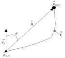
步骤2:以机场基准点所在位置为坐标原点O建立空间直角坐标系,以长为l、宽为b、高为h的网格为基本单元,以原点O为空间网格G0,0,0的中心,将终端区的三维空间划分为若干个基本网格单元,对于空间网格Gm,n,a,得到其中心坐标 (xmc,ync,zac)=(m.l,n.b,n.h);Step 2: Establish a spatial Cartesian coordinate system with the location of the airport reference point as the coordinate origin O, take the grid with length l, width b, and height h as the basic unit, and take the origin O as the spatial grid G0,0, 0 , divide the three-dimensional space of the terminal area into several basic grid units, for the spatial gridGm,n,a , get its center coordinates (xmc ,ync ,zac )=(m.l ,n.b,n.h );
步骤3:根据航迹点距空间网格中心的远近提出占据度的概念表示某一航迹对某空间网格的占据程度;将起始航迹点及转弯点称为特征航迹点,其他航迹点称为普通航迹点;设Δx,Δy和Δz分别表示航迹p(i,k)与空间网格Gm,n,a中心在横向、纵向和垂直方向上的偏离程度,计算普通航迹点的占据度o’(i,k)(m,n,a);以特征航迹点距空间网格Gm,n,a中心的椭球距离ɛ(ik)(m,n,a),计算特征航迹点的占据度o’(i,k)(m,n,a)占据度;其具体步骤如下:Step 3: According to the distance between the track point and the center of the spatial grid, the concept of occupancy is proposed to indicate the degree of occupancy of a certain track to a certain spatial grid; the initial track point and the turning point are called characteristic track points, and other Track points are called ordinary track points; let Δx , Δy and Δz denote the deviations between the trackp(i,k) and the center of the spatial gridGm,n,a in the horizontal, vertical and vertical directions respectively degree, calculate the occupancyo'(i,k) ( m,n,a ) of common track points; take the ellipsoid distanceɛ(ik) (m,n,a ), calculate the occupancyo'(i,k) (m,n,a ) occupancy of the characteristic track point; the specific steps are as follows:
a、对于普通航迹点,当Δx<l/2,Δy<b/2,Δz<h/2时,o’(i,k)(m,n,a)=1,,否则o’(i,k)(m,n,a)=0;a. For ordinary track points, when Δx<l/2 , Δy<b/2 , Δz<h/2 ,o'(i,k) (m,n,a )=1, otherwiseo'(i,k) (m,n,a )=0;
b、对于特征航迹点,当ɛ(ik)(m,n,a)不大于1时,o”(i,k)(m,n,a)=1,否则o”(i,k)(m,n,a)=1/(ɛ(ik)(m,n,a)p),p≥1;b. For characteristic track points, whenɛ(ik) (m,n,a ) is not greater than 1,o”(i,k) (m,n,a )=1, otherwiseo”(i,k) (m,n,a )=1/(ɛ(ik) (m,n,a )p ), p≥1;
c、令w1表示普通航迹占据度权重,w2表示特征航迹占据度权重;1条轨迹所有航迹点对于网格Gm,n,a的占据度oi(m,n,a)就等于o’(i,k)(m,n,a)和o”(i,k)(m,n,a)的加权求和;c. Letw1 represent the weight of common track occupancy,w2 represent the weight of characteristic track occupancy; the occupancyoi ( m,n,a of all track points of one track to grid G m,n,a ) is equal to the weighted sum ofo'(i,k) (m,n,a ) ando"(i,k) (m,n,a );
d、轨迹i和j在空间网格Gm,n,a的航迹相似性就为各自的占据度的乘积,即oi(m,n,a)×oj(m,n,a),也就是轨迹之间的局部相似度a"ii(m,n,a);d. The track similarity of trajectoriesi andj in the spatial gridGm,n,a is the product of their respective occupancy degrees, that is,oi (m,n,a )×oj (m,n,a ) , that is, the local similarity between trajectoriesa"ii (m,n,a );
步骤4:考虑到轨迹的航向因素影响,将步骤3建立的轨迹局部相似性模型基础上建立迹间整体相似性模型,其具体步骤如下:Step 4: Considering the influence of trajectory heading factors, the overall similarity model between traces is established on the basis of the local similarity model of trajectories established in step 3. The specific steps are as follows:
a、定义轨迹i的走向θi为:以磁北为基准,顺时针旋转到轨迹起始点p(i,1)与轨迹终止p(i,ni)的矢量H的夹角;a. Define the directionθi of the trajectory i as the angle between the vectorH of the trajectory start pointp(i,1) and the trajectory termination pointp(i,ni ) clockwise with magnetic north as the reference;
b、按照步骤a计算轨迹j的走向为θj;b. According to step a, the direction of trajectoryj is calculated asθj ;
c、当|θi-θj|≤π/2时,轨迹i和j相似度为:c. When |θi -θj | ≤ π/2 , the similarity between trajectoryi andj is:

否则a’ij=0,Nm,Nn和Na为终端空域在横向、纵向和垂直方向上划分的网格数量的
步骤5:构造Laplacian相似度矩阵,然后利用谱聚类算法进行聚类分析,其具体步骤如下:Step 5: Construct the Laplacian similarity matrix, and then use the spectral clustering algorithm for cluster analysis. The specific steps are as follows:
a、对步骤4中的轨迹相似度按照aij= a’ij/ a’ii进行归一化处理,得到相似度矩阵A;按照L=D-1/2(D-A)D-1/2构造Laplacian矩阵L;a. Normalize the trajectory similarity in
b、求L的特征值及特征向量,并将特征值按由大到小排列λ={λ1,λ2,…,λi,…, λn|λ1≥λ2≥…≥λn =0};计算其谱隙值,得相应的谱隙值序列δ={δ1,δ2,…, δi,…, δn-1|δi=λi-λi+1};b. Find the eigenvalues and eigenvectors of L, and arrange the eigenvalues in descending order λ={λ1 , λ2 ,… , λi ,… , λn |λ1 ≥λ2 ≥… ≥λn =0}; calculate its spectral gap value, and get the corresponding spectral gap value sequence δ={δ1 ,δ2 ,… , δi ,… , δn-1 |δi =λi -λi+1 };
c、确定聚类数k=max{δi |i=1,2,…,j,…,n-1},由前k个特征值对应的特征向量构造特征子空间,调用K-means聚类算法对特征子空间进行聚类;c. Determine the number of clusters k=max{δi |i =1,2,… ,j ,… ,n -1}, construct a feature subspace from the eigenvectors corresponding to the first k eigenvalues, and call K-means clustering The class algorithm clusters the feature subspace;
步骤6:采用核密度估计方法对步骤5得到的每一个聚类进行盛行交通流识别,其具体步骤如下:Step 6: Use the kernel density estimation method to identify the prevailing traffic flow for each cluster obtained in Step 5. The specific steps are as follows:
a、利用Laplacian Eigenmaps的方法将高维轨迹数据降到一维,即计算出的特征值中第二小的特征值所对应的特征向量
b、利用标准高斯影响函数的核密度估计函数对每一类结果进行核密度估计;b. Use the kernel density estimation function of the standard Gaussian influence function to estimate the kernel density of each type of result;
c、采用步进式爬山算法寻找估计密度函数的密度吸引点;c. Use a step-by-step hill-climbing algorithm to find the density attraction point of the estimated density function;
d、计算全局最大密度吸引点,其对应的轨迹即可代表该类的盛行交通流;d. Calculate the global maximum density attraction point, and its corresponding trajectory can represent the prevailing traffic flow of this type;
步骤7:识别结果在显示与交互模块中显示出来。Step 7: The recognition result is displayed in the display and interaction module.
本发明的优点是,从分析飞行轨迹的局部空间特征和总体走向特征出发,以完整轨迹为研究对象,建立轨迹间的相似度计算模型。利用谱聚类算法,实现了终端区轨迹样本的聚类算法,对聚类结果的每一类分别进行了核密度估计,可同时得到盛行交通流轨迹和异常轨迹,且消除异常轨迹在生成盛行交通流过程中造成的不良的影响,同时也可以检测轨迹的聚集程度。从而辅助相关人员科学、合理的规划终端区以及改善进离场航线,进而提高终端区容量。The advantage of the present invention is that, starting from the analysis of the local space characteristics and overall direction characteristics of flight trajectories, the complete trajectory is taken as the research object, and the similarity calculation model between the trajectories is established. Using the spectral clustering algorithm, the clustering algorithm of the trajectory samples in the terminal area is realized, and the kernel density is estimated for each category of the clustering results, and the prevailing traffic flow trajectory and abnormal trajectory can be obtained at the same time, and the abnormal trajectory is eliminated in the generated prevailing The adverse effects caused by the traffic flow process can also detect the aggregation degree of the trajectory. In order to assist relevant personnel to scientifically and reasonably plan the terminal area and improve the entry and departure routes, thereby increasing the capacity of the terminal area.
附图说明Description of drawings
图1,是终端区空间3D网格划分示意图;Figure 1 is a schematic diagram of the 3D grid division of the terminal area space;
图2,是实施例中一条飞行轨迹的走向图;Fig. 2 is the trend figure of a flight track in the embodiment;
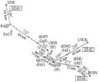
图3,是实施例中所用机场跑道进场程序构型图;Fig. 3 is the airport runway approach program configuration diagram used in the embodiment;
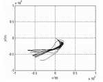
图4,是实施例中某机场29号跑道聚类结果1;Fig. 4 is the
图5,是实施例中某机场29号跑道聚类结果2;Fig. 5 is the clustering result 2 of runway No. 29 of an airport in the embodiment;
图6,是实施例中某机场29号跑道聚类结果3;Fig. 6 is the clustering result 3 of runway No. 29 of an airport in the embodiment;
图7,是实施例中某机场29号跑道聚类结果4;Fig. 7 is the
图8,是实施例中某机场29号跑道聚类结果5;Fig. 8 is the clustering result 5 of runway No. 29 of an airport in the embodiment;
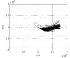
图9,是实施例中单个盛行交通流核密度估计结果;Fig. 9 is a single prevailing traffic flow kernel density estimation result in the embodiment;
图10,是实施例中盛行交通流识别结果;Fig. 10 is the recognition result of prevailing traffic flow in the embodiment;
图11,是本发明的系统总体拓扑结构图。Fig. 11 is a diagram of the overall system topology of the present invention.
图11中:1、服务器;2、第一客户端;3、第二客户端;4、第三客户端;5、第四客户端。In Fig. 11: 1. server; 2. first client; 3. second client; 4. third client; 5. fourth client.
具体实施方式Detailed ways
为了使本发明的目的、技术方案及优点更加清楚明白,以下结合附图及实施例,对本发明进行进一步详细说明,应当理解,此处所描述的具体实施例仅仅用以解释本发明,并不用于限定本发明。In order to make the objectives, technical solutions and advantages of the present invention clearer, the present invention will be described in further detail below in conjunction with the accompanying drawings and embodiments. It should be understood that the specific embodiments described here are only used to explain the present invention and are not intended to limit the invention.
现给出实现终端区盛行交通流识别的实例:An example of realizing the identification of prevailing traffic flow in the terminal area is given here:
解析某个终端区内某一个机场29号跑道飞行轨迹数据。Analyze the flight trajectory data of runway 29 of an airport in a certain terminal area.
建立数学模型。Build mathematical models.
以机场基准点所在位置为坐标原点O建立空间直角坐标系,以l=1,m=1,h=0.3(单位:km)的空间网格为基本单元,以原点O为空间网格G0,0,0的中心,则可将终端区的三维空间划分为若干个基本网格单元,对于空间网格Gm,n,a,得到其中心坐标(xmc,ync,zac)=(m.l,n.b,n.h),如图1所示,将终端区空域划成为基本单元的3D空间网格单元。Set up a spatial Cartesian coordinate system with the location of the airport reference point as the coordinate originO , take the spatial grid ofl = 1,m = 1,h = 0.3 (unit: km) as the basic unit, and take the originO as the spatial gridG0 ,0,0 , then the three-dimensional space of the terminal area can be divided into several basic grid units. For the spatial gridGm,n,a , its center coordinates (xmc ,ync ,zac )=(m. l , n. b,n. h ), as shown in Figure 1, the airspace of the terminal area is divided into 3D spatial grid units of basic units.
根据式(1)判断轨迹点是否为特征轨迹点:According to formula (1), it is judged whether the trajectory point is a characteristic trajectory point:


其中,Δt是雷达的扫描周期,g为重力加速度,v为航空器速度,μ0为转弯坡度。当两个轨迹点的航向变化ΔΦ大于给定值时,就认为这两个轨迹点为特征轨迹点,还有起始轨迹点和终止轨迹点也为特征轨迹点,其他的则视为普通轨迹点。Among them,Δt is the scanning period of the radar, g is the acceleration of gravity, v is the speed of the aircraft, andμ0 is the turning slope. When the heading changeΔΦ of two track points is greater than a given value, these two track points are considered as feature track points, and the start track point and end track point are also feature track points, and the others are regarded as ordinary track point.
计算轨迹i在终端区空间网格的占有度:若是普通轨迹点,则用式(2)计算其在终端区空间网格Gm,n,a内的占有度o’(i,k)(m,n,a);若轨迹点是特征轨迹点,则用式(3)计算其占有度。Calculate the occupancy of trajectory i in the spatial grid of the terminal area: if it is a common trajectory point, use formula (2) to calculate its occupancy in the spatial gridGm,n,a of the terminal areao'(i,k) (m,n,a ); if the trajectory point is a characteristic trajectory point, use formula (3) to calculate its occupancy.


其中,Δx,Δy和Δz分别表示航迹p(i,k)与网格Gm,n,a中心在横向、纵向和垂直方向上的偏离程度;p是一个大于1的常数,Among them, Δx , Δy and Δz respectively indicate the degree of deviation between the trackp(i,k) and the center of the gridGm,n,a in the horizontal, vertical and vertical directions;p is a constant greater than 1,

轨迹

飞行轨迹间的相似性计算:终端区飞行轨迹的聚类以及盛行交通流的识别需要以飞行轨迹整体为对象进行分析。根据系统工程的思想,轨迹

如图2所示,轨迹

式中||.||代表矢量范数,en表示指向磁北的一个单位向量,H表示p(i,1)与p(i,ni)连线的矢量。where ||. || represents the vector norm,en represents a unit vector pointing to magnetic north,H represents the vector connectingp(i,1) andp(i, ni ) .
因此,轨迹ti和tj的相似度a’ij计算如式(6):Therefore, the similaritya'ij of trajectoriesti andtj is calculated as formula (6):

其中,Nm,Nn和Na为终端空域在横向、纵向和垂直方向上划分的网格数量的
本实例中解析出该机场29号跑道一星期的1476条进场轨迹数据作为样本空间实现轨迹聚类首先,将每个轨迹数据样本映射为高维空间中的一个点,令其成为图G中的一个顶点vi。将轨迹间的相似度a’ij赋给连接顶点vi和vj的边eij。由此得到一个基于航空器轨迹样本相似度的无向加权图G(V,E),可以用连接矩阵A=( a’ij)n×n表示。In this example, 1476 arrival trajectory data of the airport’s runway 29 for one week are analyzed as sample space to realize trajectory clustering. First, each trajectory data sample is mapped to a point in the high-dimensional space, making it a point in Figure G. A vertexvi of . Assign the similaritya'ij between trajectories to the edge eij connecting verticesvi andvj . Thus, an undirected weighted graphG(V,E) based on the similarity of aircraft trajectory samples can be obtained, which can be expressed by a connection matrixA = (a'ij )n×n .
由于a’ij是由不同航迹对网格的占据度的乘积计算得到的,有时其数量差别较大,需要对相似度矩阵A1进行归一化处理。令aij= a’ij/ a’ii,得到归一化的相似度矩阵A为:Sincea'ij is calculated bythe product of grid occupancy of different tracks, sometimes the number of them differs greatly, so it is necessary to normalize the similarity matrixA1 . Letaij =a'ij /a'ii , the normalized similarity matrixA is obtained as:
其中aij=aji,对于任意i=j,aij=1。whereaij =aji , for anyi =j ,aij=1 .
进一步构造Laplacian相似度矩阵如式(7)所示:Further construct the Laplacian similarity matrix as shown in formula (7):

其中,是对角矩阵,Dii是矩阵A中的第i行所有元素之和。in, is a diagonal matrix, andDii is the sum of all elements in thei- th row of matrixA.
由于该机场29号跑道进场程序如图3所示,其进场程序有3条,编号分别为: ST-01, ST-02, ST-03; 由于地形的特殊性,当使用29号跑道时,K机场西侧的空域没有设置进场航线。考虑到该跑道只有3条进场程序,并且聚类得到的结果一般不会与原有进场程序数量相差很大,因此本实例中只给出轨迹谱聚类方法取前10个最大的特征值及对应的谱隙值δ,这已足以确定聚类结果数,如表1 所示。Since the approach procedure for runway 29 of the airport is shown in Figure 3, there are 3 approach procedures, numbered respectively: ST-01, ST-02, ST-03; due to the particularity of the terrain, when using runway 29 At that time, the airspace on the west side of K Airport did not set an approach route. Considering that there are only 3 approach procedures on this runway, and the result obtained by clustering generally does not differ greatly from the number of original arrival procedures, in this example only the trajectory spectrum clustering method is given to take the top 10 largest features value And the corresponding spectral gap value δ, which is enough to determine the number of clustering results, as shown in Table 1.
表1 轨迹相似矩阵的特征值和谱隙值Table 1 Eigenvalues and spectral gap values of trajectory similarity matrix

接下来采用的K-means聚类算法对前5个特征向量子空间进行聚类,将原始飞行轨迹分为5类,聚类结果如图4到图8所示Next, the K-means clustering algorithm is used to cluster the first 5 eigenvector subspaces, and divide the original flight trajectory into 5 categories. The clustering results are shown in Figure 4 to Figure 8
采用核密度估计的方法对上面聚类的5个簇分别进行盛行交通流识别结果如图10所示。从图10的结果中可以看出该机场的盛行交通流有6束,其中有三束和原来的标称进离场航线比较相近,而另外两束是原先没有的,这也说明了随着时间的推移,设备精度可靠性的提高以及飞行流量的加大,原先因为空域的限制不能进行飞行的区域现在也可以进行飞行了,这也说明了本发明是很用利用和科学价值的。 Using the method of kernel density estimation to identify the prevailing traffic flow of the above five clusters respectively, the results are shown in Figure 10. From the results in Figure 10, it can be seen that there are 6 prevailing traffic flows at the airport, three of which are relatively similar to the original nominal arrival and departure routes, and the other two are not originally. With the passage of time, the improvement of the accuracy and reliability of the equipment and the increase of the flight flow rate, the areas that could not be flown due to the limitation of the airspace can now be flown, which also shows that the present invention is very useful and scientifically valuable.
图11为本发明的系统总体拓扑结构图:所述计算机系统主要由客户端/服务器(C/S)模式构成,计算机系统包括:Fig. 11 is the overall topology structure diagram of the system of the present invention: the computer system is mainly composed of client/server (C/S) mode, and the computer system includes:
一个服务器1,服务器1的硬盘中安装雷达轨迹数据库,用于向客户端提供轨迹数据服务。A
第一客户端2,第一客户端2的硬盘中安装数据处理模块,用于解析雷达数据,将雷达数据转换成系统所需数据格式。The first client 2, a data processing module is installed in the hard disk of the first client 2 to analyze the radar data and convert the radar data into a data format required by the system.
第二客户端3,第二客户端3的硬盘中安装轨迹聚类模块,用于将大量轨迹按照相似度进行分类。The second client 3, a trajectory clustering module is installed in the hard disk of the second client 3, and is used to classify a large number of trajectories according to similarity.
第三客户端4,第三客户端4的硬盘中安装盛行交通流识别模块,用于识别每一类的盛行交通流。The
第三客户端5,第三客户端5的硬盘中安装显示与交互模块,用于原始轨迹、分类结果以及盛行交通流的显示与交互。The third client 5, a display and interaction module is installed in the hard disk of the third client 5, which is used for the display and interaction of the original trajectory, classification results and prevailing traffic flow.
根据上述说明,结合本领域技术可实现本发明的方案。According to the above description, the solution of the present invention can be realized in combination with the technology in the art.
Claims (1)


Priority Applications (1)
| Application Number | Priority Date | Filing Date | Title |
|---|---|---|---|
| CN201310388103.5ACN103456192B (en) | 2013-09-01 | 2013-09-01 | Terminal area prevailing traffic flow recognizing method based on track spectral clusters |
Applications Claiming Priority (1)
| Application Number | Priority Date | Filing Date | Title |
|---|---|---|---|
| CN201310388103.5ACN103456192B (en) | 2013-09-01 | 2013-09-01 | Terminal area prevailing traffic flow recognizing method based on track spectral clusters |
Publications (2)
| Publication Number | Publication Date |
|---|---|
| CN103456192Atrue CN103456192A (en) | 2013-12-18 |
| CN103456192B CN103456192B (en) | 2015-07-15 |
Family
ID=49738510
Family Applications (1)
| Application Number | Title | Priority Date | Filing Date |
|---|---|---|---|
| CN201310388103.5AExpired - Fee RelatedCN103456192B (en) | 2013-09-01 | 2013-09-01 | Terminal area prevailing traffic flow recognizing method based on track spectral clusters |
Country Status (1)
| Country | Link |
|---|---|
| CN (1) | CN103456192B (en) |
Cited By (18)
| Publication number | Priority date | Publication date | Assignee | Title |
|---|---|---|---|---|
| CN104504897A (en)* | 2014-09-28 | 2015-04-08 | 北京工业大学 | Intersection traffic flow characteristic analysis and vehicle moving prediction method based on trajectory data |
| CN105023468A (en)* | 2015-08-06 | 2015-11-04 | 北京航空航天大学 | Terminal area airline safety tolerance monitoring method based on collision risk model and system thereof |
| CN105261240A (en)* | 2015-09-30 | 2016-01-20 | 中国民用航空总局第二研究所 | Integrated sector operation performance detection method based on cluster analysis and system |
| CN106774314A (en)* | 2016-12-11 | 2017-05-31 | 北京联合大学 | A kind of home-services robot paths planning method based on run trace |
| CN107315994A (en)* | 2017-05-12 | 2017-11-03 | 长安大学 | Clustering algorithm based on Spectral Clustering space trackings |
| CN107808518A (en)* | 2017-10-26 | 2018-03-16 | 东南大学 | A kind of traffic zone division methods theoretical based on multi-path spectral clustering |
| CN109145415A (en)* | 2018-08-06 | 2019-01-04 | 中国民航大学 | A kind of transport air flow headway distribution! analysis method |
| CN109697456A (en)* | 2018-11-21 | 2019-04-30 | 华为技术有限公司 | Business diagnosis method, apparatus, equipment and storage medium |
| CN110299063A (en)* | 2018-03-22 | 2019-10-01 | 阿里巴巴集团控股有限公司 | The visual presentation method and device of track data |
| CN110335507A (en)* | 2019-06-12 | 2019-10-15 | 中国电子科技集团公司第二十八研究所 | Analysis method of flight operation situation law based on air traffic control track big data |
| CN110443287A (en)* | 2019-07-19 | 2019-11-12 | 北京航空航天大学 | A kind of mobile stream method for drafting of the crowd based on sparse track data |
| CN111125925A (en)* | 2019-12-30 | 2020-05-08 | 中国人民解放军93209部队 | Terminal area airspace space-time correlation analysis method driven by aircraft track data |
| CN111488849A (en)* | 2020-04-17 | 2020-08-04 | 中国民航大学 | Method for identifying characteristics of circular spiral in track |
| CN111694913A (en)* | 2020-06-05 | 2020-09-22 | 海南大学 | Ship AIS (automatic identification System) track clustering method and device based on convolution self-encoder |
| CN113344239A (en)* | 2021-04-25 | 2021-09-03 | 山东师范大学 | Traffic congestion condition prediction method and system based on two-stage spectral clustering |
| CN113962283A (en)* | 2021-09-01 | 2022-01-21 | 南京航空航天大学 | An Aircraft Trajectory Clustering Method Based on Local Adaptive Dynamic Time Warping |
| CN115565090A (en)* | 2022-11-04 | 2023-01-03 | 四川启睿克科技有限公司 | Unmanned aerial vehicle unsupervised identification method and device based on radar data |
| CN115661363A (en)* | 2022-11-18 | 2023-01-31 | 湖北晓雲科技有限公司 | Three-dimensional building model construction method utilizing unmanned aerial vehicle oblique photography |
Citations (3)
| Publication number | Priority date | Publication date | Assignee | Title |
|---|---|---|---|---|
| CN101334845A (en)* | 2007-06-27 | 2008-12-31 | 中国科学院自动化研究所 | A Video Behavior Recognition Method Based on Trajectory Sequence Analysis and Rule Induction |
| US20110064267A1 (en)* | 2009-09-17 | 2011-03-17 | Wesley Kenneth Cobb | Classifier anomalies for observed behaviors in a video surveillance system |
| CN102855778A (en)* | 2012-09-10 | 2013-01-02 | 南京航空航天大学 | Space-domain sector classification method based on complexity assessment |
- 2013
- 2013-09-01CNCN201310388103.5Apatent/CN103456192B/ennot_activeExpired - Fee Related
Patent Citations (3)
| Publication number | Priority date | Publication date | Assignee | Title |
|---|---|---|---|---|
| CN101334845A (en)* | 2007-06-27 | 2008-12-31 | 中国科学院自动化研究所 | A Video Behavior Recognition Method Based on Trajectory Sequence Analysis and Rule Induction |
| US20110064267A1 (en)* | 2009-09-17 | 2011-03-17 | Wesley Kenneth Cobb | Classifier anomalies for observed behaviors in a video surveillance system |
| CN102855778A (en)* | 2012-09-10 | 2013-01-02 | 南京航空航天大学 | Space-domain sector classification method based on complexity assessment |
Non-Patent Citations (4)
| Title |
|---|
| CHANG-SHING PERNG ET AL.: "A New Model for Similarity-Based Pattern Querying in Time Series Databases", 《DATA ENGINEERING, 2000. PROCEEDINGS. 16TH INTERNATIONAL CONFERENCE ON》, 3 May 2000 (2000-05-03), pages 33 - 42* |
| 王超等: "基于航迹聚类的终端区进场程序管制适用性分析", 《南京航空航天大学学报》, vol. 45, no. 1, 19 April 2013 (2013-04-19)* |
| 袁冠等: "基于结构相似度的轨迹聚类算法", 《通信学报》, vol. 32, no. 9, 21 February 2012 (2012-02-21)* |
| 龚玺等: "时空轨迹聚类方法研究进展", 《地理科学进展》, vol. 30, no. 5, 31 August 2011 (2011-08-31)* |
Cited By (28)
| Publication number | Priority date | Publication date | Assignee | Title |
|---|---|---|---|---|
| CN104504897A (en)* | 2014-09-28 | 2015-04-08 | 北京工业大学 | Intersection traffic flow characteristic analysis and vehicle moving prediction method based on trajectory data |
| CN105023468A (en)* | 2015-08-06 | 2015-11-04 | 北京航空航天大学 | Terminal area airline safety tolerance monitoring method based on collision risk model and system thereof |
| CN105261240A (en)* | 2015-09-30 | 2016-01-20 | 中国民用航空总局第二研究所 | Integrated sector operation performance detection method based on cluster analysis and system |
| CN106774314A (en)* | 2016-12-11 | 2017-05-31 | 北京联合大学 | A kind of home-services robot paths planning method based on run trace |
| CN107315994B (en)* | 2017-05-12 | 2020-08-18 | 长安大学 | Clustering Method Based on Spectral Clustering Spatial Trajectory |
| CN107315994A (en)* | 2017-05-12 | 2017-11-03 | 长安大学 | Clustering algorithm based on Spectral Clustering space trackings |
| CN107808518A (en)* | 2017-10-26 | 2018-03-16 | 东南大学 | A kind of traffic zone division methods theoretical based on multi-path spectral clustering |
| CN110299063A (en)* | 2018-03-22 | 2019-10-01 | 阿里巴巴集团控股有限公司 | The visual presentation method and device of track data |
| CN110299063B (en)* | 2018-03-22 | 2022-01-25 | 阿里巴巴集团控股有限公司 | Visual display method and device for trajectory data |
| CN109145415A (en)* | 2018-08-06 | 2019-01-04 | 中国民航大学 | A kind of transport air flow headway distribution! analysis method |
| CN109145415B (en)* | 2018-08-06 | 2023-04-18 | 中国民航大学 | Air traffic flow time distance distribution analysis method |
| CN109697456A (en)* | 2018-11-21 | 2019-04-30 | 华为技术有限公司 | Business diagnosis method, apparatus, equipment and storage medium |
| CN110335507B (en)* | 2019-06-12 | 2021-01-26 | 中国电子科技集团公司第二十八研究所 | Analysis method of flight operation situation law based on air traffic control track big data |
| CN110335507A (en)* | 2019-06-12 | 2019-10-15 | 中国电子科技集团公司第二十八研究所 | Analysis method of flight operation situation law based on air traffic control track big data |
| CN110443287B (en)* | 2019-07-19 | 2022-01-14 | 北京航空航天大学 | Crowd moving stream drawing method based on sparse trajectory data |
| CN110443287A (en)* | 2019-07-19 | 2019-11-12 | 北京航空航天大学 | A kind of mobile stream method for drafting of the crowd based on sparse track data |
| CN111125925A (en)* | 2019-12-30 | 2020-05-08 | 中国人民解放军93209部队 | Terminal area airspace space-time correlation analysis method driven by aircraft track data |
| CN111125925B (en)* | 2019-12-30 | 2024-03-22 | 中国人民解放军93209部队 | Terminal area airspace space-time correlation analysis method driven by aircraft track data |
| CN111488849A (en)* | 2020-04-17 | 2020-08-04 | 中国民航大学 | Method for identifying characteristics of circular spiral in track |
| CN111488849B (en)* | 2020-04-17 | 2022-05-17 | 中国民航大学 | Method for identifying characteristics of circular spiral in track |
| CN111694913A (en)* | 2020-06-05 | 2020-09-22 | 海南大学 | Ship AIS (automatic identification System) track clustering method and device based on convolution self-encoder |
| CN111694913B (en)* | 2020-06-05 | 2023-07-11 | 海南大学 | Ship AIS track clustering method and device based on convolution self-encoder |
| CN113344239A (en)* | 2021-04-25 | 2021-09-03 | 山东师范大学 | Traffic congestion condition prediction method and system based on two-stage spectral clustering |
| CN113962283A (en)* | 2021-09-01 | 2022-01-21 | 南京航空航天大学 | An Aircraft Trajectory Clustering Method Based on Local Adaptive Dynamic Time Warping |
| CN113962283B (en)* | 2021-09-01 | 2024-12-20 | 南京航空航天大学 | A method for clustering aircraft trajectories based on local adaptive dynamic time warping |
| CN115565090A (en)* | 2022-11-04 | 2023-01-03 | 四川启睿克科技有限公司 | Unmanned aerial vehicle unsupervised identification method and device based on radar data |
| CN115661363A (en)* | 2022-11-18 | 2023-01-31 | 湖北晓雲科技有限公司 | Three-dimensional building model construction method utilizing unmanned aerial vehicle oblique photography |
| CN115661363B (en)* | 2022-11-18 | 2023-04-11 | 湖北晓雲科技有限公司 | Three-dimensional building model construction method utilizing unmanned aerial vehicle oblique photography |
Also Published As
| Publication number | Publication date |
|---|---|
| CN103456192B (en) | 2015-07-15 |
Similar Documents
| Publication | Publication Date | Title |
|---|---|---|
| CN103456192B (en) | Terminal area prevailing traffic flow recognizing method based on track spectral clusters | |
| Zeng et al. | Aircraft trajectory clustering in terminal airspace based on deep autoencoder and gaussian mixture model | |
| Hong et al. | Trajectory prediction for vectored area navigation arrivals | |
| Zeng et al. | A Deep Graph‐Embedded LSTM Neural Network Approach for Airport Delay Prediction | |
| Enriquez et al. | A simple and robust flow detection algorithm based on spectral clustering | |
| US11790767B2 (en) | Method, apparatus, device and storage medium for pre-warning of aircraft flight threat evolution | |
| CN105023468A (en) | Terminal area airline safety tolerance monitoring method based on collision risk model and system thereof | |
| EP3443482B1 (en) | Classifying entities in digital maps using discrete non-trace positioning data | |
| CN115393745A (en) | Automatic bridge image progress identification method based on unmanned aerial vehicle and deep learning | |
| CN105225541A (en) | Based on the method for Trajectory Prediction in short-term that blank pipe historical data is excavated | |
| CN112101405A (en) | Robust depth self-encoder and density peak value-based track clustering and abnormal value identification method | |
| Ma et al. | LA-YOLO: an effective detection model for multi-UAV under low altitude background | |
| Du et al. | Airport capacity prediction with multisource features: A temporal deep learning approach | |
| Jiang et al. | Research on method of trajectory prediction in aircraft flight based on aircraft performance and historical track data | |
| Yang et al. | A holistic approach for optimal pre-planning of multi-path standardized taxiing routes | |
| CN110135451A (en) | A Track Clustering Method Based on the Distance from Point to Line Segment Set | |
| Sudarsanan et al. | Deep-Learning Framework for Terminal Airspace Trajectory Prediction and In-Time Prognostics | |
| Zhang et al. | Air traffic flow pattern recognition and analysis in terminal area based on the geodesic distance | |
| CN118246640A (en) | A method for constructing gridded flight plan data based on three-dimensional grid division | |
| Tang et al. | Predicting aircraft taxiing estimated time of arrival by cluster analysis | |
| CN117892236A (en) | Airport scene operation scene classification method and system | |
| CN109979244B (en) | Method and device for predicting airspace congestion for heterogeneous aircraft | |
| CN114596733B (en) | Airline conflict detection method and device | |
| Xu et al. | Data-Driven Departure Flight Time Prediction Based on Feature Construction and Ensemble Learning | |
| Yang et al. | Multi-Airport Capacity Decoupling Analysis Using Hybrid and Integrated Surface–Airspace Traffic Modeling |
Legal Events
| Date | Code | Title | Description |
|---|---|---|---|
| C06 | Publication | ||
| PB01 | Publication | ||
| C10 | Entry into substantive examination | ||
| SE01 | Entry into force of request for substantive examination | ||
| C14 | Grant of patent or utility model | ||
| GR01 | Patent grant | ||
| CF01 | Termination of patent right due to non-payment of annual fee | ||
| CF01 | Termination of patent right due to non-payment of annual fee | Granted publication date:20150715 Termination date:20210901 |