CN103389090A - Measurement method for initial speed of polar area navigation mode of inertial navigation system - Google Patents
Measurement method for initial speed of polar area navigation mode of inertial navigation systemDownload PDFInfo
- Publication number
- CN103389090A CN103389090ACN2013103223223ACN201310322322ACN103389090ACN 103389090 ACN103389090 ACN 103389090ACN 2013103223223 ACN2013103223223 ACN 2013103223223ACN 201310322322 ACN201310322322 ACN 201310322322ACN 103389090 ACN103389090 ACN 103389090A
- Authority
- CN
- China
- Prior art keywords
- inertial navigation
- navigation system
- coordinate system
- theta
- polar
- Prior art date
- Legal status (The legal status is an assumption and is not a legal conclusion. Google has not performed a legal analysis and makes no representation as to the accuracy of the status listed.)
- Pending
Links
Images
Landscapes
- Navigation (AREA)
Abstract
Translated fromChineseDescription
Translated fromChinese技术领域technical field
本发明属于惯性导航系统极区导航技术领域,尤其涉及一种惯性导航系统极区导航模式初始速度的测量方法。The invention belongs to the technical field of polar region navigation of an inertial navigation system, and in particular relates to a method for measuring the initial velocity of a polar region navigation mode of an inertial navigation system.
背景技术Background technique
惯性导航系统对于保障船舶、飞机等在极区的航行与作业至关重要。然而目前我国常用的固定指北方位惯性导航系统,其机械编排无法在极区使用。为克服惯性导航系统上述机械编排无法在极区进行导航解算这一缺点,导航领域的研究人员设计出自由方位和游动方位机械编排。自由方位系统和游动方位系统在平台的方位指令上采取了措施,解决了极区航行时平台方位角施矩速率信号过大的问题。它们可解决惯性导航系统极区工作的部分问题,但由于极区经线圈的快速汇聚会导致系统位置矩阵的误差,进一步使得系统导航精度随纬度的升高而下降。同时,在地理极点附近,由于真北方向失去定义导致自由方位角和游动方位角失去定义,航向无法给出,即采用这两种机械编排惯性导航系统在地理极点附近无法导航。Inertial navigation system is very important to ensure the navigation and operation of ships and aircraft in polar regions. However, the fixed north azimuth inertial navigation system commonly used in our country at present cannot be used in polar regions due to its mechanical arrangement. In order to overcome the shortcoming that the above-mentioned mechanical arrangement of the inertial navigation system cannot perform navigation calculations in polar regions, researchers in the field of navigation have designed free azimuth and swimming azimuth mechanical arrangements. The free azimuth system and the swimming azimuth system have taken measures on the azimuth command of the platform to solve the problem that the azimuth angle moment rate signal of the platform is too large when navigating in polar regions. They can solve some of the problems of the inertial navigation system working in the polar region, but the rapid convergence of the polar warp coils will cause the error of the system position matrix, which further makes the system navigation accuracy decrease with the increase of latitude. At the same time, near the geographical pole, due to the loss of definition of the true north direction, the definition of free azimuth and swimming azimuth is lost, and the heading cannot be given, that is, the two kinds of mechanically arranged inertial navigation systems cannot navigate near the geographical pole.
解决这个问题可以采用横坐标系导航参考框架。运载体航行至极区时,转入极区导航模式,即采用横坐标系参考框架。横坐标参考框架是指惯性导航系统以横地理坐标系为导航坐标系,在横地理坐标系内解算导航参数,包括速度,位置等信息。由于依然采用的是通过加速度积分来求解速度的方式,因此在进入极区模式时需要横坐标系参考框架下速度的初始值。但是惯性导航系统存在的正常模式转入极区模式时速度信息的初始化问题。To solve this problem, an abscissa navigation reference frame can be used. When the carrier sails to the polar region, it will switch to the polar region navigation mode, that is, the reference frame of the abscissa system will be adopted. The abscissa reference frame means that the inertial navigation system uses the abscissa geographic coordinate system as the navigation coordinate system, and calculates the navigation parameters in the abscissa coordinate system, including information such as speed and position. Since the speed is still calculated by integrating the acceleration, the initial value of the speed under the reference frame of the abscissa system is required when entering the polar mode. However, the inertial navigation system has the problem of initializing the speed information when the normal mode is transferred to the polar mode.
发明内容Contents of the invention
本发明实施例的目的在于提供一种惯性导航系统极区导航模式初始速度的测量方法,旨在解决惯性导航系统由正常模式转入极区模式时速度信息的初始化的问题。The purpose of the embodiments of the present invention is to provide a method for measuring the initial speed of the polar region navigation mode of the inertial navigation system, aiming at solving the problem of initializing the speed information when the inertial navigation system is transferred from the normal mode to the polar region mode.
本发明实施例是这样实现的,一种惯性导航系统极区导航模式初始速度的测量方法,该惯性导航系统极区导航模式初始速度的测量方法包括以下步骤:The embodiment of the present invention is achieved in this way, a method for measuring the initial speed of the polar region navigation mode of the inertial navigation system, the method for measuring the initial speed of the polar region navigation mode of the inertial navigation system comprises the following steps:
采集惯性导航系统正常模式下输出信息;Collect the output information of the inertial navigation system in normal mode;
测量惯性导航系统与东经90°之间的经度差;Measuring the longitude difference between the inertial navigation system and 90° East;
计算辅助系数W;Calculate the auxiliary coefficient W;
测量地理坐标系与横地理坐标系之间的转角;Measure the rotation angle between the geographic coordinate system and the horizontal geographic coordinate system;
计算地理坐标系与横地理坐标系之间的方向余弦矩阵;Calculate the direction cosine matrix between the geographic coordinate system and the horizontal geographic coordinate system;
测量惯性惯性导航系统极区模式的初始速度。Measure the initial velocity of the inertial inertial navigation system in polar mode.
进一步,该惯性导航系统极区导航模式初始速度的测量方法具体步骤为:Further, the specific steps of the method for measuring the initial speed of the polar region navigation mode of the inertial navigation system are:
步骤一:采集惯性导航系统正常模式输出的经度信息λ,纬度信息L和速度信息v;Step 1: collecting the longitude information λ, latitude information L and velocity information v output by the inertial navigation system in normal mode;
步骤二:测量惯性导航系统所在位置与东经90°经线的经度差δλ;Step 2: Measure the longitude difference δλ between the position of the inertial navigation system and the 90° east longitude line;
步骤三:利用步骤一中的纬度信息L计算辅助系数W;Step 3: Using the latitude information L in step 1 to calculate the auxiliary coefficient W;
步骤四:利用步骤三中的W测量地理坐标系与横地理坐标系之间的转角θ;Step 4: Utilize W in step 3 to measure the rotation angle θ between the geographic coordinate system and the horizontal geographic coordinate system;
步骤五:利用步骤六中得到的地理坐标系与横地理坐标系之间的转角θ构造地理坐标系与横地理坐标系之间的方向余弦矩阵
步骤六:由步骤五中得到的
进一步,在步骤二中,经度差δλ表示为:δλ=λ-90。Further, in step 2, the longitude difference δλ is expressed as: δλ=λ-90.
进一步,在步骤三中:辅助系数W表示为:
进一步,在步骤四中:地理坐标系与横地理坐标系之间的转角θ表示为:Further, in step four: the rotation angle θ between the geographic coordinate system and the horizontal geographic coordinate system is expressed as:
进一步,在步骤五中:地理坐标系与横地理坐标系之间的方向余弦矩阵
进一步,在步骤六中:惯性导航系统极区模式的初始速度表示为:Further, in step 6: the initial velocity of the inertial navigation system polar mode is expressed as:
其中

本发明提供的惯性导航系统极区导航模式初始速度的测量方法,基于地球椭球模型求取正常模式与极区模式导航坐标系之间的转换矩阵,避免了简单以常规球体模拟地球时求取转换矩阵的误差,从而减小惯性导航系统模式转换的误差。本发明只需惯性导航系统正常模式下的输出信息就可以测量出极区模式所需的初始速度信息,不需要其他外部设备和信息,测量方法简单方便,有利于实际应用。此外,本发明填补了惯性导航系统极区导航模式初始速度测量方法的空白,解决了惯性导航系统由正常模式转入极区模式时速度信息的初始化问题。The method for measuring the initial speed of the polar region navigation mode of the inertial navigation system provided by the present invention is based on the earth ellipsoid model to obtain the conversion matrix between the normal mode and the polar region mode navigation coordinate system, which avoids the simple calculation of the earth when simulating the earth with a conventional sphere The error of the conversion matrix, thereby reducing the error of the mode conversion of the inertial navigation system. The invention only needs the output information of the inertial navigation system in the normal mode to measure the initial speed information required by the polar region mode, and does not need other external equipment and information, and the measurement method is simple and convenient, which is beneficial to practical application. In addition, the invention fills in the blank of the initial speed measurement method of the polar region navigation mode of the inertial navigation system, and solves the initialization problem of the speed information when the inertial navigation system is transferred from the normal mode to the polar region mode.
附图说明Description of drawings
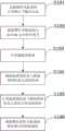
图1是本发明实施例提供的惯性导航系统极区导航模式初始速度的测量方法的流程图。Fig. 1 is a flow chart of the method for measuring the initial speed of the polar region navigation mode of the inertial navigation system provided by the embodiment of the present invention.
具体实施方式Detailed ways
为了使本发明的目的、技术方案及优点更加清楚明白,以下结合实施例,对本发明进行进一步详细说明。应当理解,此处所描述的具体实施例仅仅用以解释本发明,并不用于限定本发明。In order to make the object, technical solution and advantages of the present invention more clear, the present invention will be further described in detail below in conjunction with the examples. It should be understood that the specific embodiments described here are only used to explain the present invention, not to limit the present invention.
图1示出了本发明提供的惯性导航系统极区导航模式初始速度的测量方法流程。为了便于说明,仅仅示出了与本发明相关的部分。Fig. 1 shows the flow of the method for measuring the initial speed of the polar region navigation mode of the inertial navigation system provided by the present invention. For ease of illustration, only the parts relevant to the present invention are shown.
本发明的惯性导航系统极区导航模式初始速度的测量方法,该惯性导航系统极区导航模式初始速度的测量方法包括以下步骤:The method for measuring the initial speed of the polar region navigation mode of the inertial navigation system of the present invention, the method for measuring the initial speed of the polar region navigation mode of the inertial navigation system comprises the following steps:
采集惯性导航系统正常模式下输出信息;Collect the output information of the inertial navigation system in normal mode;
测量惯性导航系统与东经90°之间的经度差;Measuring the longitude difference between the inertial navigation system and 90° East;
计算辅助系数W;Calculate the auxiliary coefficient W;
测量地理坐标系与横地理坐标系之间的转角;Measure the rotation angle between the geographic coordinate system and the horizontal geographic coordinate system;
计算地理坐标系与横地理坐标系之间的方向余弦矩阵;Calculate the direction cosine matrix between the geographic coordinate system and the horizontal geographic coordinate system;
测量惯性惯性导航系统极区模式的初始速度。Measure the initial velocity of the inertial inertial navigation system in polar mode.
作为本发明实施例的一优化方案,该惯性导航系统极区导航模式初始速度的测量方法具体步骤为:As an optimization scheme of the embodiment of the present invention, the specific steps of the method for measuring the initial velocity of the polar region navigation mode of the inertial navigation system are as follows:
步骤一:采集惯性导航系统正常模式输出的经度信息λ,纬度信息L和速度信息v;Step 1: collecting the longitude information λ, latitude information L and velocity information v output by the inertial navigation system in normal mode;
步骤二:测量惯性导航系统所在位置与东经90°经线的经度差δλ;Step 2: Measure the longitude difference δλ between the position of the inertial navigation system and the 90° east longitude line;
步骤三:利用步骤一中的纬度信息L计算辅助系数W;Step 3: Using the latitude information L in step 1 to calculate the auxiliary coefficient W;
步骤四:利用步骤三中的W测量地理坐标系与横地理坐标系之间的转角θ;Step 4: Utilize W in step 3 to measure the rotation angle θ between the geographic coordinate system and the horizontal geographic coordinate system;
步骤五:利用步骤六中得到的地理坐标系与横地理坐标系之间的转角θ构造地理坐标系与横地理坐标系之间的方向余弦矩阵Step 5: Use the rotation angle θ between the geographic coordinate system and the horizontal geographic coordinate system obtained in step 6 to construct the direction cosine matrix between the geographic coordinate system and the horizontal geographic coordinate system
步骤六:由步骤五中得到的
作为本发明实施例的一优化方案,在步骤二中,经度差δλ表示为:δλ=|λ-90|。As an optimization scheme of the embodiment of the present invention, in step 2, the longitude difference δλ is expressed as: δλ=|λ−90|.
作为本发明实施例的一优化方案,在步骤三中:辅助系数W表示为:
作为本发明实施例的一优化方案,在步骤四中:地理坐标系与横地理坐标系之间的转角θ表示为:As an optimization scheme of the embodiment of the present invention, in step 4: the rotation angle θ between the geographic coordinate system and the horizontal geographic coordinate system is expressed as:
作为本发明实施例的一优化方案,在步骤五中:地理坐标系与横地理坐标系之间的方向余弦矩阵
作为本发明实施例的一优化方案,在步骤六中:惯性导航系统极区模式的初始速度表示为:As an optimization scheme of the embodiment of the present invention, in step 6: the initial speed of the polar mode of the inertial navigation system is expressed as:
其中和
下面结合附图及具体实施例对本发明的应用原理作进一步描述。The application principle of the present invention will be further described below in conjunction with the accompanying drawings and specific embodiments.
如图1所示,本发明实施例的惯性导航系统极区导航模式初始速度的测量方法包括以下步骤:As shown in Figure 1, the method for measuring the initial speed of the polar region navigation mode of the inertial navigation system of the embodiment of the present invention includes the following steps:
S101:采集惯性导航系统正常模式下输出信息;S101: Collect output information of the inertial navigation system in normal mode;
S102:测量惯性导航系统与东经90°之间的经度差;S102: Measuring the longitude difference between the inertial navigation system and 90° east longitude;
S103:计算辅助系数W;S103: Calculate the auxiliary coefficient W;
S104:测量地理坐标系与横地理坐标系之间的转角;S104: measuring the rotation angle between the geographic coordinate system and the horizontal geographic coordinate system;
S105:计算地理坐标系与横地理坐标系之间的方向余弦矩阵;S105: Calculate the direction cosine matrix between the geographic coordinate system and the horizontal geographic coordinate system;
S106:测量惯性惯性导航系统极区模式的初始速度。S106: Measure the initial speed of the polar mode of the inertial inertial navigation system.
本发明的具体步骤如下:Concrete steps of the present invention are as follows:
步骤一:采集惯性导航系统正常模式输出的经度信息λ,纬度信息L和速度信息v;Step 1: collecting the longitude information λ, latitude information L and velocity information v output by the inertial navigation system in normal mode;
步骤二:测量惯性导航系统所在位置与东经90°经线的经度差δλ:Step 2: Measure the longitude difference δλ between the position of the inertial navigation system and the 90° east longitude:
δλ=|λ-90|δλ=|λ-90|
步骤三:利用步骤一中的纬度信息L计算辅助系数W:Step 3: Use the latitude information L in step 1 to calculate the auxiliary coefficient W:
步骤四:利用步骤三中的W测量地理坐标系与横地理坐标系之间的转角θ:Step 4: Use W in step 3 to measure the rotation angle θ between the geographic coordinate system and the horizontal geographic coordinate system:
步骤五:利用步骤六中得到的地理坐标系与横地理坐标系之间的转角θ构造地理坐标系与横地理坐标系之间的方向余弦矩阵
步骤六:由步骤五中得到的
其中
惯性导航系统正常模式输出参数:经度信息λ,纬度信息L,东向速度vx、北向速度vy和天向速度vz;惯性导航系统极区模式输出参数:横东向速度


本发明具体实施方式:The specific embodiment of the present invention:
步骤一,惯性导航系统行至纬度为70度时开始由正常模式转换为极区模式;Step 1, when the inertial navigation system travels to a latitude of 70 degrees, it starts to switch from the normal mode to the polar mode;
步骤二,采集惯性导航系统正常模式输出的位置信息:经度λ和地理纬度L;Step 2, collecting the position information output by the normal mode of the inertial navigation system: longitude λ and geographic latitude L;
步骤三,测量惯性导航系统所在位置与东经90°经线的经度差δλ:Step 3, measure the longitude difference δλ between the position of the inertial navigation system and the 90° east longitude:
δλ=|λ-90|δλ=|λ-90|
步骤四,利用步骤二中的纬度信息L计算辅助系数W:Step 4, use the latitude information L in step 2 to calculate the auxiliary coefficient W:
步骤五,利用步骤四中的W测量地理坐标系与横地理坐标系之间的转角θ:Step five, using W in step four to measure the rotation angle θ between the geographic coordinate system and the horizontal geographic coordinate system:
步骤六,利用步骤五中得到的地理坐标系与横地理坐标系之间的转角θ构造地理坐标系与横地理坐标系之间的方向余弦矩阵
步骤七,由步骤六中得到的测量惯性导航系统极区模式的初始速度:Step seven, obtained from step six Measure the initial velocity of the INS polar mode:
其中

以上所述仅为本发明的较佳实施例而已,并不用以限制本发明,凡在本发明的精神和原则之内所作的任何修改、等同替换和改进等,均应包含在本发明的保护范围之内。The above descriptions are only preferred embodiments of the present invention, and are not intended to limit the present invention. Any modifications, equivalent replacements and improvements made within the spirit and principles of the present invention should be included in the protection of the present invention. within range.
Claims (7)


Priority Applications (1)
| Application Number | Priority Date | Filing Date | Title |
|---|---|---|---|
| CN2013103223223ACN103389090A (en) | 2013-07-29 | 2013-07-29 | Measurement method for initial speed of polar area navigation mode of inertial navigation system |
Applications Claiming Priority (1)
| Application Number | Priority Date | Filing Date | Title |
|---|---|---|---|
| CN2013103223223ACN103389090A (en) | 2013-07-29 | 2013-07-29 | Measurement method for initial speed of polar area navigation mode of inertial navigation system |
Publications (1)
| Publication Number | Publication Date |
|---|---|
| CN103389090Atrue CN103389090A (en) | 2013-11-13 |
Family
ID=49533435
Family Applications (1)
| Application Number | Title | Priority Date | Filing Date |
|---|---|---|---|
| CN2013103223223APendingCN103389090A (en) | 2013-07-29 | 2013-07-29 | Measurement method for initial speed of polar area navigation mode of inertial navigation system |
Country Status (1)
| Country | Link |
|---|---|
| CN (1) | CN103389090A (en) |
Cited By (5)
| Publication number | Priority date | Publication date | Assignee | Title |
|---|---|---|---|---|
| CN103940428A (en)* | 2014-03-21 | 2014-07-23 | 哈尔滨工程大学 | Transverse speed real-time measuring method of inertial navigation system |
| CN103983277A (en)* | 2014-05-16 | 2014-08-13 | 哈尔滨工程大学 | Comprehensive inertial navigation system correction method applied to polar region |
| CN103983277B (en)* | 2014-05-16 | 2016-11-30 | 哈尔滨工程大学 | A kind of inertial navigation system synthesis correction method being applicable to polar region |
| CN117470233A (en)* | 2023-11-10 | 2024-01-30 | 中国人民解放军国防科技大学 | An optimized abscissa coordinate system integrated navigation method under the earth ellipsoid model |
| CN117470234A (en)* | 2023-11-10 | 2024-01-30 | 中国人民解放军国防科技大学 | Cross-polar region filter switching method for ships based on Psi angle error model |
Citations (2)
| Publication number | Priority date | Publication date | Assignee | Title |
|---|---|---|---|---|
| US5448486A (en)* | 1993-04-29 | 1995-09-05 | Honeywell Inc. | Orthogonal polar coordinate system to accommodate polar navigation |
| CN103090867A (en)* | 2012-11-02 | 2013-05-08 | 哈尔滨工程大学 | Error restraining method for fiber-optic gyroscope strapdown inertial navigation system rotating relative to geocentric inertial system |
- 2013
- 2013-07-29CNCN2013103223223Apatent/CN103389090A/enactivePending
Patent Citations (2)
| Publication number | Priority date | Publication date | Assignee | Title |
|---|---|---|---|---|
| US5448486A (en)* | 1993-04-29 | 1995-09-05 | Honeywell Inc. | Orthogonal polar coordinate system to accommodate polar navigation |
| CN103090867A (en)* | 2012-11-02 | 2013-05-08 | 哈尔滨工程大学 | Error restraining method for fiber-optic gyroscope strapdown inertial navigation system rotating relative to geocentric inertial system |
Non-Patent Citations (2)
| Title |
|---|
| 刘文超等: "游移方位INS/GPS组合导航在极地地区的应用", 《火力与指挥控制》* |
| 周琪等: "极区飞行格网惯性导航算法原理", 《西北工业大学学报》* |
Cited By (7)
| Publication number | Priority date | Publication date | Assignee | Title |
|---|---|---|---|---|
| CN103940428A (en)* | 2014-03-21 | 2014-07-23 | 哈尔滨工程大学 | Transverse speed real-time measuring method of inertial navigation system |
| CN103983277A (en)* | 2014-05-16 | 2014-08-13 | 哈尔滨工程大学 | Comprehensive inertial navigation system correction method applied to polar region |
| CN103983277B (en)* | 2014-05-16 | 2016-11-30 | 哈尔滨工程大学 | A kind of inertial navigation system synthesis correction method being applicable to polar region |
| CN117470233A (en)* | 2023-11-10 | 2024-01-30 | 中国人民解放军国防科技大学 | An optimized abscissa coordinate system integrated navigation method under the earth ellipsoid model |
| CN117470234A (en)* | 2023-11-10 | 2024-01-30 | 中国人民解放军国防科技大学 | Cross-polar region filter switching method for ships based on Psi angle error model |
| CN117470234B (en)* | 2023-11-10 | 2024-04-26 | 中国人民解放军国防科技大学 | Ship cross-polar filtering switching method based on Psi angle error model |
| CN117470233B (en)* | 2023-11-10 | 2024-06-21 | 中国人民解放军国防科技大学 | An optimized combined navigation method of horizontal coordinate system under the earth ellipsoid model |
Similar Documents
| Publication | Publication Date | Title |
|---|---|---|
| CN100487378C (en) | Data blending method of navigation system combined by SINS/GPS micromagnetic compass | |
| CN101858748B (en) | Fault-tolerance autonomous navigation method of multi-sensor of high-altitude long-endurance unmanned plane | |
| CN103471616B (en) | Initial Alignment Method under a kind of moving base SINS Large azimuth angle condition | |
| CN104880191B (en) | A kind of polarization auxiliary navigation method based on solar vector | |
| CN106767752A (en) | A kind of Combinated navigation method based on polarization information | |
| CN105021198B (en) | A kind of location estimation method navigated based on MULTISENSOR INTEGRATION | |
| CN108151737B (en) | Unmanned aerial vehicle swarm cooperative navigation method under condition of dynamic mutual observation relationship | |
| CN104374388A (en) | Flight attitude determining method based on polarized light sensor | |
| CN110887509B (en) | A multi-directional calibration method of compound eye-like polarization sensor | |
| CN102393201A (en) | Dynamic lever arm compensating method of position and posture measuring system (POS) for aerial remote sensing | |
| CN105891863A (en) | High-constraint based extended Kalman filter (EKF) positioning method | |
| CN109059964A (en) | A kind of inertial navigation based on gravity peak and the double calibration methods of gravity measurement | |
| CN109506660B (en) | Attitude optimization resolving method for bionic navigation | |
| CN103712621B (en) | Polarised light and infrared sensor are assisted inertial navigation system method for determining posture | |
| CN105928515A (en) | Navigation system for unmanned plane | |
| CN107907898A (en) | Polar region SINS/GPS Integrated Navigation Algorithms based on grid frame | |
| CN105910623B (en) | The method for carrying out the correction of course using magnetometer assisted GNSS/MINS tight integration systems | |
| CN103398712B (en) | The collaborative navigation method alternately navigated | |
| CN102707080B (en) | Method for simulating strapdown inertial navigation gyroscope by using star sensor | |
| CN106885573A (en) | Towards the motion capture system Real-time Determination of Attitude method of quadrotor | |
| CN102393204B (en) | Combined navigation information fusion method based on SINS (Ship's Inertial Navigation System)/CNS (Communication Network System) | |
| CN103940429A (en) | Real-time measuring method of carrier attitude in transverse coordinate system of inertial navigation system | |
| CN103453907A (en) | Planet entering section navigation filtering method based on layered atmosphere model | |
| CN104535080A (en) | Error quaternion-based transmission aligning method under large heading misalignment angle | |
| CN104949687A (en) | Whole parameter precision evaluation method for long-time navigation system |
Legal Events
| Date | Code | Title | Description |
|---|---|---|---|
| C06 | Publication | ||
| PB01 | Publication | ||
| C10 | Entry into substantive examination | ||
| SE01 | Entry into force of request for substantive examination | ||
| WD01 | Invention patent application deemed withdrawn after publication | Application publication date:20131113 | |
| WD01 | Invention patent application deemed withdrawn after publication |