CN103017739A - Manufacturing method of true digital ortho map (TDOM) based on light detection and ranging (LiDAR) point cloud and aerial image - Google Patents
Manufacturing method of true digital ortho map (TDOM) based on light detection and ranging (LiDAR) point cloud and aerial imageDownload PDFInfo
- Publication number
- CN103017739A CN103017739ACN2012104728860ACN201210472886ACN103017739ACN 103017739 ACN103017739 ACN 103017739ACN 2012104728860 ACN2012104728860 ACN 2012104728860ACN 201210472886 ACN201210472886 ACN 201210472886ACN 103017739 ACN103017739 ACN 103017739A
- Authority
- CN
- China
- Prior art keywords
- point cloud
- airborne lidar
- image
- lidar point
- true
- Prior art date
- Legal status (The legal status is an assumption and is not a legal conclusion. Google has not performed a legal analysis and makes no representation as to the accuracy of the status listed.)
- Granted
Links
- 238000001514detection methodMethods0.000titledescription11
- 238000004519manufacturing processMethods0.000titledescription4
- 238000000034methodMethods0.000description37
- 230000009466transformationEffects0.000description16
- 238000001914filtrationMethods0.000description15
- 238000005516engineering processMethods0.000description13
- 238000000605extractionMethods0.000description11
- 238000004422calculation algorithmMethods0.000description10
- 239000000284extractSubstances0.000description10
- 238000004458analytical methodMethods0.000description6
- 230000000694effectsEffects0.000description6
- 238000012545processingMethods0.000description6
- 238000011160researchMethods0.000description6
- 230000008569processEffects0.000description5
- 238000011161developmentMethods0.000description4
- 230000018109developmental processEffects0.000description4
- 238000003708edge detectionMethods0.000description4
- 230000001788irregularEffects0.000description4
- 238000005259measurementMethods0.000description4
- 238000012876topographyMethods0.000description4
- 238000004364calculation methodMethods0.000description3
- 230000008520organizationEffects0.000description3
- 238000007781pre-processingMethods0.000description3
- PXFBZOLANLWPMH-UHFFFAOYSA-N16-EpiaffinineNatural productsC1C(C2=CC=CC=C2N2)=C2C(=O)CC2C(=CC)CN(C)C1C2COPXFBZOLANLWPMH-UHFFFAOYSA-N0.000description2
- 230000009286beneficial effectEffects0.000description2
- 230000008859changeEffects0.000description2
- 230000014509gene expressionEffects0.000description2
- 230000003287optical effectEffects0.000description2
- XLYOFNOQVPJJNP-UHFFFAOYSA-NwaterSubstancesOXLYOFNOQVPJJNP-UHFFFAOYSA-N0.000description2
- 238000012952ResamplingMethods0.000description1
- 230000002159abnormal effectEffects0.000description1
- 238000003491arrayMethods0.000description1
- 238000004891communicationMethods0.000description1
- 230000000295complement effectEffects0.000description1
- 238000012937correctionMethods0.000description1
- 230000007547defectEffects0.000description1
- 238000013461designMethods0.000description1
- 238000010586diagramMethods0.000description1
- 238000009826distributionMethods0.000description1
- 239000000428dustSubstances0.000description1
- 238000002474experimental methodMethods0.000description1
- 238000007667floatingMethods0.000description1
- 230000006872improvementEffects0.000description1
- 230000010365information processingEffects0.000description1
- 238000011835investigationMethods0.000description1
- 238000007726management methodMethods0.000description1
- 238000012544monitoring processMethods0.000description1
- 238000005457optimizationMethods0.000description1
- 230000000717retained effectEffects0.000description1
- 238000005070samplingMethods0.000description1
- 230000011218segmentationEffects0.000description1
- 238000011524similarity measureMethods0.000description1
- 238000004088simulationMethods0.000description1
- 230000007704transitionEffects0.000description1
- 230000000007visual effectEffects0.000description1
- 238000012800visualizationMethods0.000description1
Images


Landscapes
- Image Processing (AREA)
Abstract
Translated fromChineseDescription
Translated fromChinese技术领域technical field
本发明属于摄影测量应用领域,特别是基于激光雷达点云与航空影像的真正射影像的制作方法。The invention belongs to the application field of photogrammetry, in particular to a method for making true orthoimages based on laser radar point clouds and aerial images.
背景技术Background technique
随着计算机技术和通信技术的迅速发展,数字化的地理信息已成为城市乃至整个国家在各个领域宏观决策和规划管理中必不可少的支撑条件,因此对基础地理信息数据的精度及现实性都提出了相当高的要求。同时由于地理信息系统的发展,对基础地理信息数据的形式提出了更多的要求,不仅需要矢量数据、栅格数据,还需要形象直观的图像数据。摄影测量直接获取的地面数码影像往往由于传感器姿态或者地形起伏等原因,存在地物位置偏差及地物变形的问题。经过正射纠正,可以有效剔除由于传感器和相机旋转、地形起伏以及在图像获取和处理过程中产生的位置误差,最终生成无变形、同时具有地图几何精度和影像特征的图像,即数字正射影像(Digital Ortho-photo Map,DOM)。因此,数字正射影像以其信息量丰富、直观、应用广泛等特点在城市规划、土地资源利用和调查以及基础地理信息系统中发挥着越来越大的作用。With the rapid development of computer technology and communication technology, digital geographic information has become an indispensable support condition for cities and even the whole country in macro-decision-making and planning management in various fields. Therefore, the accuracy and reality of basic geographic information data are raised. quite high requirements. At the same time, due to the development of geographic information systems, more requirements are put forward for the form of basic geographic information data, not only vector data, raster data, but also visual image data. Ground digital images directly acquired by photogrammetry often have problems such as position deviation and deformation of ground objects due to sensor attitude or terrain fluctuations. After orthorectification, it can effectively eliminate the position error caused by the rotation of the sensor and camera, terrain fluctuations, and image acquisition and processing, and finally generate an image without deformation, with map geometric accuracy and image characteristics, that is, a digital orthophoto (Digital Ortho-photo Map, DOM). Therefore, digital orthophotos are playing an increasingly important role in urban planning, land resource utilization and survey, and basic geographic information systems due to their rich information, intuition, and wide application.
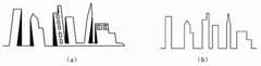
传统的数字正射影像是采用数字地面模型(Digital Terrain Model,DTM)进行正射纠正。然而,随着影像获取手段的不断发展和各部门需求的不断进步,传统概念上的数字正射影像已不能满足应用需求了。其地形地貌虽然经过了正射纠正,但是人工建筑等地形上存在着投影差。在人类活动频繁、建筑物密集的城市区域,高大建筑物对地表信息造成了遮挡,而且影像拼接和接边区域地物过渡实现起来十分困难,严重影响了应用效果。因此,专家提出了真正射影像(True Digital Ortho Map,TDOM)的概念,通过高精度的数字表面模型(DigitalSurface Model,DSM),采用数字微分纠正,改正原始影像的几何变形,建立垂直视角的地表景观[1],避免城市区域高大建筑物对其他地表信息的遮挡,解决大比例尺城区正射影像拼接困难以及拼接后影像接边区域不自然等弊端。传统正射影像和真正射影像的对比图参见图1~2,从图1~2可以看出,传统正射影像是倾斜视角,高大建筑物的投影遮挡了地面信息,地物信息不够准确;而真正射影像消除了这些影响,对后续利用真正射影像进行地物分析和量测提供了良好的数据源。因此,真正射影像的相关研究具有很强的现实意义。Traditional digital orthophotos are orthorectified using Digital Terrain Model (DTM). However, with the continuous development of image acquisition methods and the continuous improvement of the needs of various departments, the traditional concept of digital orthophotos can no longer meet the application requirements. Although its topography has been orthorectified, there are projection differences in artificial buildings and other terrains. In urban areas with frequent human activities and dense buildings, tall buildings block surface information, and it is very difficult to realize image stitching and ground object transition in border areas, which seriously affects the application effect. Therefore, experts put forward the concept of True Digital Ortho Map (TDOM), through high-precision digital surface model (Digital Surface Model, DSM), using digital differential correction, correcting the geometric deformation of the original image, and establishing a vertical view of the surface Landscape[1] , avoiding the occlusion of other surface information by tall buildings in urban areas, solving the difficulties of stitching large-scale urban orthophotos and the unnatural border areas of images after stitching. See Figure 1~2 for the comparison between traditional orthophotos and true orthophotos. From Figures 1~2, it can be seen that traditional orthophotos are oblique perspectives, and the projections of tall buildings block ground information, and the ground object information is not accurate enough; The real orthophotos eliminate these effects, and provide a good data source for subsequent ground object analysis and measurement using the real orthophotos. Therefore, the related research on true orthoimages has strong practical significance.
在真正射影像的制作技术上,国内外学者均进行了一定探讨和研究。如利用微软公司的UltraCaml相机获取的航空影像进行密集匹配生成数字表面模型(Digital Surface Model,DSM),进而获得真正射影像[2];为了研究复杂的文物表面,使用激光扫描数据和覆盖文物所有表面的数码照片生成真正射影像[3];将航空影像与建筑物、道路和地形模型结合生成真正射影像[4]。国内的学者也进行了相关研究工作,潘慧波等[5]介绍了结合激光雷达和同步采集的数码影像生成真正射影像的可行性方法。目前,在国内,真正射影像的生产主要采用的是法国的INFOTERRA公司开发的“像素工厂”(Pixel Factory)系统和德国的Inpho数字摄影测量系统[6]。Scholars at home and abroad have conducted some discussions and researches on the production technology of true orthophotos. For example, use the aerial images acquired by Microsoft’s UltraCaml camera to perform dense matching to generate a digital surface model (Digital Surface Model, DSM), and then obtain the real orthographic image[2] ; in order to study the complex surface of cultural relics, use laser scanning data and cover all cultural relics Digital photographs of surfaces generate true orthoimages[3] ; aerial imagery is combined with models of buildings, roads, and terrain to generate true orthoimages[4] . Domestic scholars have also carried out related research work. Pan Huibo et al.[5] introduced a feasible method of combining laser radar and synchronously collected digital images to generate true orthophotos. At present, in China, the production of true orthophotos mainly adopts the “Pixel Factory” system developed by INFOTERRA in France and the Inpho digital photogrammetry system in Germany[6] .
正射纠正是生成正射影像的关键步骤。正射纠正通常采用共线方程法,利用共线条件方程,结合影像和数字高程模型(Digital Elevation Model,DEM)进行正射纠正。传统的正射纠正无法检测建筑物对其他地物存在的遮挡,从而影响生成的正射影像质量,因此遮蔽检测成为生成真正射影像的重要步骤,也成为国内外研究的热点。遮蔽检测方法有基于矢量建筑物模型的Z-buffer方法[7]、基于栅格DSM模型的Z-buffer方法[8]、基于角度的检测方法和基于角度和高程信息的射线追踪法[9]等。国内的王潇、江万寿等[10]提出了一种基于高程面投影的迭代检测算法。Orthorectification is a key step in generating orthophotos. Orthorectification usually adopts the collinear equation method, using the collinear conditional equation, combined with images and Digital Elevation Model (Digital Elevation Model, DEM) for orthorectification. Traditional orthorectification cannot detect the occlusion of buildings on other ground objects, which affects the quality of the generated orthoimage. Therefore, occlusion detection has become an important step in generating true orthoimages, and has become a research hotspot at home and abroad. The shading detection methods include the Z-buffer method based on the vector building model[7] , the Z-buffer method based on the grid DSM model[8] , the angle-based detection method and the ray tracing method based on angle and elevation information[9] wait. Domestic Wang Xiao, Jiang Wanshou et al.[10] proposed an iterative detection algorithm based on elevation plane projection.
激光雷达(Light Detection and Ranging,简称LiDAR)作为一种新型的对地观测技术,用于直接快速地获取地球表面的三维空间信息,具有速度快、精度高、信息量大等优点,为数据应用提供了更加丰富的信息,备受应用者和研究者的广泛关注。目前LiDAR技术广泛应用于地面景观形体量测、古建筑与古文物保护、复杂工业设备的量测与建模、城市三维可视化模型的建立、森林和农业资源调查、变形监测等领域,显示出巨大的应用前景。毋庸置疑,LiDAR技术的出现会推动遥感数据应用领域的进一步发展。LiDAR (Light Detection and Ranging, referred to as LiDAR), as a new type of earth observation technology, is used to directly and quickly obtain three-dimensional spatial information on the earth's surface. It has the advantages of fast speed, high precision, and large amount of information. It provides richer information and has attracted extensive attention from users and researchers. At present, LiDAR technology is widely used in the measurement of ground landscape shape, the protection of ancient buildings and cultural relics, the measurement and modeling of complex industrial equipment, the establishment of three-dimensional visualization models of cities, the investigation of forest and agricultural resources, and deformation monitoring. application prospects. There is no doubt that the emergence of LiDAR technology will promote the further development of remote sensing data applications.
由前述真正射影像的研究现状可知,将多种数据源结合生成真正射影像是真正射影像生成领域的一个重要研究方向。真正射影像的质量主要取决于DSM的质量,而利用LiDAR技术能更快速的生成DSM并提高DSM的质量,而DSM的质量直接影响生成的真正射影像的质量。因此,可以将LiDAR技术用于生产真正射影像,用来提高真正射影像的质量。From the aforementioned research status of true orthophotos, it can be seen that combining multiple data sources to generate true orthophotos is an important research direction in the field of true orthophoto generation. The quality of the real orthophoto mainly depends on the quality of the DSM, and the use of LiDAR technology can generate DSM faster and improve the quality of the DSM, and the quality of the DSM directly affects the quality of the generated real orthophoto. Therefore, LiDAR technology can be used to produce real orthophotos, which can be used to improve the quality of real orthophotos.
然而,采用LiDAR技术虽然能够直接获取地物目标的空间几何三维信息,但其工作模式是靠回波接受主动工作模式来获取地表高程信息,因此利用LiDAR所获取的数据本身存在缺陷:①由于遮挡、物体特性(如水面)等因素,会出现一些区域回波信息被吸收而没有数据的情况;②当激光束遇到地物边缘部分回波会发生折射,导致地物边缘部分数据不完整;③数据采样时按时间间隔或空间间隔来进行,数据是离散的点集,点集之外一些重要信息被丢失。因此,一方面采用LiDAR技术难以直接获得物体表面的语义信息(例如纹理和结构等),另一方面它所获得的空间三维点云数据具有不连续性、不规则性以及数据密度不均匀等特性,直接利用LiDAR点云数据实现地物三维信息精确提取还很困难[11]。从目前很多研究来看,单独利用LiDAR点云数据进行地物的分类和识别等自动智能化的处理具有很大难度。However, although LiDAR technology can directly obtain the spatial geometric three-dimensional information of ground objects, its working mode relies on the active mode of echo reception to obtain surface elevation information. Therefore, the data obtained by using LiDAR itself has defects: ① Due to the , object characteristics (such as water surface) and other factors, there will be cases where the echo information in some areas is absorbed and there is no data; ②When the laser beam meets the edge part of the object, the echo will be refracted, resulting in incomplete data on the edge part of the object; ③ Data sampling is carried out according to time interval or space interval. The data is a discrete point set, and some important information outside the point set is lost. Therefore, on the one hand, it is difficult to directly obtain the semantic information (such as texture and structure) of the object surface by using LiDAR technology; However, it is still very difficult to directly use LiDAR point cloud data to accurately extract 3D information of ground objects[11] . Judging from many current studies, it is very difficult to use LiDAR point cloud data alone for automatic and intelligent processing such as classification and recognition of ground objects.
文中涉及的参考文献如下:The references involved in the article are as follows:
[1]史照良,沈泉飞,曹敏.像素工厂中真正射影像的生产及其精度分析[J].测绘科学技术学报.2007(5):332-335.[1] Shi Zhaoliang, Shen Quanfei, Cao Min. Production and Accuracy Analysis of True Orthophotos in Pixel Factory [J]. Journal of Surveying and Mapping Science and Technology. 2007(5): 332-335.
[2]Alexander Wiechert M.DSM and Ortho Generation with the Ultracam-L--A Case Study[Z].San Diego,California:2010.[2]Alexander Wiechert M.DSM and Ortho Generation with the Ultracam-L--A Case Study[Z].San Diego,California:2010.
[3]Alshawabkeh Y.A NEW TRUE ORTHO-PHOTO METHODOLOGY FOR COMPLEXARCHAEOLOGICAL APPLICATION[J].Archaeometry.2010,52(3):517-530.[3]Alshawabkeh Y.A NEW TRUE ORTHO-PHOTO METHODOLOGY FOR COMPLEXARCHAEOLOGICAL APPLICATION[J].Archaeometry.2010,52(3):517-530.
[4]Shin-Hui Li L C.True Ortho-rectification for Aerial Photos by the Integration of Building,Road,and Terrain Models[J].Journal of Photogrammetry and Remote Sensing.2008,13(2):116-125.[4]Shin-Hui Li L C.True Ortho-rectification for Aerial Photos by the Integration of Building,Road,and Terrain Models[J].Journal of Photogrammetry and Remote Sensing.2008,13(2):116-125.
[5]潘慧波,胡友健,王大莹.从LiDAR数据中获取DSM生成真正射影像[J].测绘工程.2009(3):47-50.[5] Pan Huibo, Hu Youjian, Wang Daying. Obtaining DSM from LiDAR data to generate true orthoimages [J]. Surveying and Mapping Engineering. 2009(3): 47-50.
[6]万从容,郭容寰,杨常红.数字真正射影像的研制[J].上海地质.2009(4):33-36.2009(4):33-36.[6] Wan Congrong, Guo Ronghuan, Yang Changhong. Development of Digital True Orthophotos [J]. Shanghai Geology. 2009(4):33-36.2009(4):33-36.
[7]Amhar F.The Generation of True Orthophotos Using a 3D Builing Model in Conjunctionwith a Conventional DTM[J].International Archives of Photogrammet ry and Remote Sensing,1998,32(Part4):16222[7]Amhar F.The Generation of True Orthophotos Using a 3D Building Model in Conjunctionwith a Conventional DTM[J].International Archives of Photogrammet ry and Remote Sensing,1998,32(Part4):16222
[8]Rau J,Chen N,Chen L.True Orthophoto Generation of Built-up Areas Using MultiviewImages[J].Photogrammet ric Engineering & Remote Sensing,2002,68(6).[8]Rau J, Chen N, Chen L.True Orthophoto Generation of Built-up Areas Using MultiviewImages[J].Photogrammetric Engineering & Remote Sensing,2002,68(6).
[9]Wai Yeung Yan,Ahmed Shaker,Ayman Habib,Ana Paula Kerstingb.Improvingclassification accuracy of airborne LiDAR intensity data by geometric calibration and radiometriccorrection[J].ISPRS Journal ofPhotogrammetry and Remote Sensing,2012(67):35–44[9] Wai Yeung Yan, Ahmed Shaker, Ayman Habib, Ana Paula Kerstingb. Improving classification accuracy of airborne LiDAR intensity data by geometric calibration and radiometric correction [J]. ISPRS Journal of Photogrammetry and Remote Sensing, 2012 (
[10]王潇,江万寿,谢俊峰.一种新的真正射影像生成算法[J].武汉大学学报(信息科学版).2009(10):1250-1254.[10] Wang Xiao, Jiang Wanshou, Xie Junfeng. A new true orthophoto generation algorithm [J]. Journal of Wuhan University (Information Science Edition). 2009(10): 1250-1254.
[11]程亮.集成影像与LiDAR数据重建三维建筑物模型研究[D].武汉:武汉大学,2008.[11] Cheng Liang. Research on 3D Building Model Reconstruction by Integrated Image and LiDAR Data [D]. Wuhan: Wuhan University, 2008.
发明内容Contents of the invention
针对现有技术中存在的问题,本发明将机载LiDAR点云和航空影像结合,并基于此提出了一种真正射影像的制作方法,该方法能提高真正射影像的生成速度和生成质量。Aiming at the problems existing in the prior art, the present invention combines the airborne LiDAR point cloud with the aerial image, and based on this, proposes a method for making a real orthophoto, which can improve the generation speed and quality of the real orthophoto.
本发明方法的基本思路是:数据获取方式决定了机载LiDAR点云数据中屋顶点等面状特征明显,利于区域特征提取,而航空影像数据中房屋等边缘轮廓异常清晰,便于边缘特征的准确提取;机载LiDAR点云数据的平面精度和高程精度相关,且机载LiDAR系统误差源较多,误差传播模型较为复杂,而摄影测量数据平面精度和高程精度相互独立,平面精度高于高程精度,二者具有较强的互补性。因此,可以将机载LiDAR点云数据和航空影像数据进行融合,利用匹配技术获得的立体航空影像的密集点云与机载LiDAR点云进行配准和融合,生成高质量的DSM,进而采用DSM对已经解算方位元素的多视角航空影像对进行正射纠正,辅以后续处理,包括遮挡区域的检测和纹理补偿复原等,从而实现快速生成高质量的真正射影像。The basic idea of the method of the present invention is: the data acquisition method determines that the surface features such as roof points in the airborne LiDAR point cloud data are obvious, which is beneficial to the extraction of regional features, while the edge contours of houses in the aerial image data are extremely clear, which is convenient for accurate edge features. Extraction; the plane accuracy of airborne LiDAR point cloud data is related to the elevation accuracy, and there are many error sources in the airborne LiDAR system, and the error propagation model is relatively complex, while the plane accuracy and elevation accuracy of photogrammetry data are independent of each other, and the plane accuracy is higher than the elevation accuracy , the two are highly complementary. Therefore, airborne LiDAR point cloud data and aerial image data can be fused, and the dense point cloud of stereoscopic aerial images obtained by matching technology can be registered and fused with airborne LiDAR point cloud to generate high-quality DSM, and then use DSM Perform orthorectification on the multi-view aerial image pairs that have already solved the azimuth elements, supplemented by subsequent processing, including detection of occluded areas and texture compensation restoration, etc., so as to quickly generate high-quality true orthoimages.
为了解决上述技术问题,本发明采用如下的技术方案:In order to solve the problems of the technologies described above, the present invention adopts the following technical solutions:
一种基于激光雷达点云与航空影像的真正射影像的制作方法,包括步骤:A method for making a real orthophoto based on a lidar point cloud and an aerial image, comprising the steps of:
对机载LiDAR点云依次进行预处理、组织和滤波后进行特征提取;The airborne LiDAR point cloud is preprocessed, organized and filtered in turn for feature extraction;
对原始航空影像立体像对进行匹配获取立体航空影像,并提取立体航空影像的特征,所提取的立体航空影像的特征与机载LiDAR点云的特征为同类特征;Match the stereo pairs of the original aerial images to obtain stereoscopic aerial images, and extract the features of the stereoscopic aerial images. The features of the extracted stereoscopic aerial images are similar to those of the airborne LiDAR point cloud;
基于所提取的特征对立体航空影像的密集点云和滤波后的机载LiDAR点云进行配准,获得DSM;Based on the extracted features, the dense point cloud of the stereo aerial image and the filtered airborne LiDAR point cloud are registered to obtain the DSM;
根据DSM进行真正射影像制作。Real orthophoto production according to DSM.
上述对预处理后的机载LiDAR点云进行组织具体为:The above-mentioned organization of the preprocessed airborne LiDAR point cloud is as follows:
对预处理后的机载LiDAR点云进行表达,并对经表达后的机载LiDAR点云进行重采样。Express the preprocessed airborne LiDAR point cloud, and resample the expressed airborne LiDAR point cloud.
所述的对预处理后的机载LiDAR点云进行表达的优选方案为:The preferred scheme for expressing the preprocessed airborne LiDAR point cloud is:
采用规则格网对预处理后的机载LiDAR点云中的低密度点云区域进行表达,采用不规则三角网对预处理后的机载LiDAR点云中的高密度点云区域进行表达。The regular grid is used to express the low-density point cloud area in the preprocessed airborne LiDAR point cloud, and the irregular triangular mesh is used to express the high-density point cloud area in the preprocessed airborne LiDAR point cloud.
上述对机载LiDAR点云进行特征提取具体为:The above-mentioned feature extraction of the airborne LiDAR point cloud is as follows:
获取滤波后的机载LiDAR点云的深度图像,并基于深度图像对机载LiDAR点云进行特征提取。基于深度图像对机载LiDAR点云进行特征提取的优选方案为基于深度图像对机载LiDAR点云进行线特征提取。Obtain the depth image of the filtered airborne LiDAR point cloud, and perform feature extraction on the airborne LiDAR point cloud based on the depth image. The optimal solution for feature extraction of airborne LiDAR point cloud based on depth image is line feature extraction of airborne LiDAR point cloud based on depth image.
所述的基于深度图像对机载LiDAR点云进行线特征提取具体为:The described line feature extraction of the airborne LiDAR point cloud based on the depth image is specifically:
基于深度图像提取机载LiDAR点云的二维直线特征:首先在深度图像上进行边缘检测,并提取深度图像中的边缘点序列;然后,根据边缘点序列将边缘点连接成各小直线;最后,对各小直线段进行拟合得到二维直线特征;Extract the two-dimensional straight line features of the airborne LiDAR point cloud based on the depth image: firstly, edge detection is performed on the depth image, and the edge point sequence in the depth image is extracted; then, the edge points are connected into small straight lines according to the edge point sequence; finally , fitting each small straight line segment to obtain the two-dimensional straight line feature;
并对提取的二维直线特征建立左右两个缓冲区,比较两个缓冲区内点云的高差以确定建筑物的内、外侧,取位于建筑物内侧的缓冲区内的点在竖直方向上对二维直线特征进行拟合,获得包括道路和桥梁信息的线特征。And establish two left and right buffer zones for the extracted two-dimensional straight line features, compare the height difference of the point clouds in the two buffer zones to determine the inside and outside of the building, and take the points in the buffer zone inside the building in the vertical direction The two-dimensional straight line features are fitted to obtain line features including road and bridge information.
上述立体航空影像的密集点云采用如下方法获得:The dense point cloud of the above three-dimensional aerial image is obtained by the following method:
提取立体航空影像对应的原始航空影像立体像对的稀疏点特征,根据所提取的稀疏点特征进行立体匹配获得稀疏点对应的稠密同名点,即为立体航空影像的密集点云。Extract the sparse point features of the original aerial image stereo pair corresponding to the stereo aerial image, and perform stereo matching according to the extracted sparse point features to obtain the dense points with the same name corresponding to the sparse point, which is the dense point cloud of the stereo aerial image.
上述获得DSM的步骤进一步包括对航空影像的密集点云和滤波后的机载LiDAR点云进行粗配准和精配准两个子步骤,其中:The above step of obtaining the DSM further includes two sub-steps of coarse registration and fine registration of the dense point cloud of the aerial image and the filtered airborne LiDAR point cloud, wherein:
所述的对航空影像的密集点云和机载LiDAR点云进行粗配准具体为:The detailed registration of the dense point cloud of the aerial image and the airborne LiDAR point cloud is as follows:
根据采集航空影像和机载LiDAR点云时飞机的位置与姿态获取匹配初始位置;通过人工给定的对应点确定航空影像和机载LiDAR点云的位置关系,从而得到一个初始空间三维相似变换T;通过点云数据和航空影像中对应特征的匹配过程,计算同名特征,并代入到仿射变换的转换模型中,优化初始空间三维相似变换T的仿射变换参数,获取配准参数;According to the position and attitude of the aircraft when collecting aerial images and airborne LiDAR point clouds, the initial matching position is obtained; the positional relationship between aerial images and airborne LiDAR point clouds is determined by manually given corresponding points, so as to obtain an initial spatial three-dimensional similarity transformation T ;Through the matching process of the point cloud data and the corresponding features in the aerial image, calculate the feature with the same name, and substitute it into the transformation model of affine transformation, optimize the affine transformation parameters of the initial space three-dimensional similarity transformation T, and obtain the registration parameters;
所述的对航空影像的密集点云和机载LiDAR点云进行精配准具体为:The fine registration of the dense point cloud of the aerial image and the airborne LiDAR point cloud is specifically as follows:
根据粗配准获取的配准参数进一步确定航空影像区域和方向;获取两种点云数据中三维表面点集之间的最优匹配的几何变换,从而获得DSM。According to the registration parameters obtained by rough registration, the area and direction of the aerial image are further determined; the geometric transformation of the optimal match between the three-dimensional surface point sets in the two point cloud data is obtained, so as to obtain the DSM.
上述根据DSM进行真正射影像制作进一步包括以下子步骤:基于DSM对立体航空影像和滤波后的机载LiDAR点云进行正射纠正得到正射影像;The above-mentioned making of real orthophotos according to DSM further includes the following sub-steps: based on DSM, performing orthorectification to stereoscopic aerial images and filtered airborne LiDAR point clouds to obtain orthophotos;
对正射影像上建筑物遮挡区域进行自动检测、侯选补偿影像可见性分析、最佳补偿影像自动确定、遮挡区域纹理补偿策略、补偿影像匀光匀色、绝对遮挡区域计算和真实纹理复原,生产真正射影像。Automatic detection of building occlusion areas on orthophotos, visibility analysis of candidate compensation images, automatic determination of optimal compensation images, texture compensation strategy for occlusion areas, light and color uniformity of compensation images, absolute occlusion area calculation and real texture restoration, Produce real orthoimages.
与现有技术相比,本发明具有以下优点和有益效果:Compared with the prior art, the present invention has the following advantages and beneficial effects:
1)采用本发明方法可以生成高质量DSM,从而可得到高质量的真正射影像。1) Using the method of the present invention can generate a high-quality DSM, thereby obtaining a high-quality true orthoimage.
直接使用LiDAR点云数据生成城市区域的DSM,对城市区域的复杂性特别是各种人工建筑物考虑不足,也未考虑LiDAR点云数据传感器本身的特点,无法生成高质量的DSM。但本发明分别提取航空影像立体像对匹配后生成的密集点云融合LiDAR点云数据获得高质量的DSM。Directly using LiDAR point cloud data to generate DSM of urban areas does not consider the complexity of urban areas, especially various artificial buildings, and does not consider the characteristics of LiDAR point cloud data sensors themselves, so high-quality DSM cannot be generated. However, the present invention extracts dense point clouds generated after aerial image stereo pair matching and fuses LiDAR point cloud data to obtain high-quality DSM.
2)基于高质量的DSM,使用遮挡区域快速检测、最佳补偿影像定位、纹理补偿与模拟复原等技术制作真正射影像产品,改变传统正射影像使用数字高程模型DEM进行纠正,克服无法对投影差和地物进行纠正的缺点,能更加真实准确地表达地形地貌,参见图3,采用本发明方法得到的真正射影像去除了投影差,能更真实的反映地形地貌。2) Based on high-quality DSM, use technologies such as rapid detection of occlusion areas, optimal compensation image positioning, texture compensation and simulation restoration to produce real orthophoto products, and change traditional orthophotos to correct using digital elevation model DEM to overcome the inability to correct projections The shortcomings of correcting the difference and ground objects can express the topography more truly and accurately. Referring to Figure 3, the real orthoimage obtained by using the method of the present invention removes the projection difference and can reflect the topography more truly.
3)本发明的优选方案是基于线特征对机载LiDAR点云以及航空影像进行高精度匹配。3) The preferred solution of the present invention is to perform high-precision matching of airborne LiDAR point clouds and aerial images based on line features.
机载LiDAR点云与光学影像的配准必须从配准基元、相似性测度以及配准策略方面进行特殊考虑。遥感数据的配准基元通常分为点特征、线特征和面特征。点特征的配准方法主要采用灰度区域方法进行处理,很难在LiDAR数据和光学影像中找到同名点;基于线特征的配准方法主要利用地物边缘特性的相似性进行,但LiDAR数据与影像数据的差异,同名特征线的匹配是需要突破的难点;面特征方法通常是利用面特征相似性测度方程完成配准。本发明首先利用航空影像生成密集点云,提取其中的道路以及桥梁信息等从而与LiDAR点云数据的线状特征进行匹配,解算出方位参数。The registration of airborne LiDAR point cloud and optical image must be specially considered in terms of registration primitives, similarity measures and registration strategies. The registration primitives of remote sensing data are usually divided into point features, line features and surface features. The point feature registration method mainly uses the gray-scale area method for processing, and it is difficult to find the same name point in LiDAR data and optical images; the line feature-based registration method mainly uses the similarity of the edge characteristics of the ground object, but LiDAR data and The difference in image data and the matching of feature lines with the same name are the difficulties that need to be overcome; the surface feature method usually uses the surface feature similarity measurement equation to complete the registration. The present invention first uses aerial images to generate dense point clouds, extracts road and bridge information, etc., to match with the linear features of LiDAR point cloud data, and calculates the orientation parameters.
附图说明Description of drawings
图1为传统正射影像和真正射影像中建筑物倾斜与遮蔽效果的对比图,其中,图(a)为传统正射影像中建筑物的倾斜与遮蔽效果,图(b)为真正射影像中建筑物的倾斜与遮蔽效果;Figure 1 is a comparison of the building tilt and shading effect in the traditional orthophoto and the real orthophoto, where picture (a) shows the building tilt and shading effect in the traditional orthophoto, and picture (b) is the real orthophoto The inclination and shading effect of the building in the middle;
图2为传统正射影像和真正射影像视角的对比图,其中,图(a)为传统正射影像视角图,图(b)为真正射影像视角图;Figure 2 is a comparison diagram of traditional orthophoto and real orthophoto viewing angles, where picture (a) is a traditional orthophoto viewing angle, and picture (b) is a real orthophoto viewing angle;
图3为采用传统正射纠正生成的正射影像和真正射影像的对比,其中,图(a)为次啊月传统正射纠正生成的正射影像,图(b)为真正射影像;Figure 3 is a comparison between the orthophoto and the real orthophoto generated by traditional ortho-rectification, where picture (a) is the ortho-image generated by the traditional ortho-rectification of the next month, and picture (b) is the real ortho image;
图4为滤波处理前后的机载LiDAR点云数据的对比,其中,图(a)为未进行滤波处理的机载载LiDAR点云,图(b)为经滤波处理后的机载载LiDAR点云;Figure 4 is a comparison of the airborne LiDAR point cloud data before and after filtering, where (a) is the airborne LiDAR point cloud without filtering, and (b) is the airborne LiDAR point after filtering cloud;
图5为分割后的机载LiDAR建筑物点云区域;Figure 5 is the segmented airborne LiDAR building point cloud area;
图6为本发明具体实施所获取的DSM;Fig. 6 is the DSM obtained by the specific implementation of the present invention;
图7为本发明具体实施所生成的真正射影像;Fig. 7 is the real orthoimage generated by the specific implementation of the present invention;
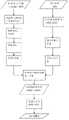
图8为本发明具体实施的流程图。Fig. 8 is a flow chart of the specific implementation of the present invention.
具体实施方式Detailed ways
下面将结合附图和具体实施对本发明做进一步说明。The present invention will be further described below in conjunction with the accompanying drawings and specific implementation.
本发明的基于激光雷达点云与航空影像的真正射影像的制作方法,包括以下步骤:The method for making a real orthophoto image based on a laser radar point cloud and an aerial image of the present invention comprises the following steps:
步骤一,对机载LiDAR点云进行预处理;Step 1, preprocessing the airborne LiDAR point cloud;
机载LiDAR系统在采集数据时,由于其内部误差和物体表面镜面反射等原因,会产生一些噪声点,严重干扰后续操作。为了剔除系统误差和噪声,准确利用机载LiDAR点云进行后续处理,必须对机载LiDAR点云进行预处理以去除粗差点,包括去除重复点、高程异常点、孤立点、空中的点等,例如由于激光打在通往地下室台阶上产生的高程明显低的点,属于高程异常点;激光打到水面上的垃圾、漂浮物等形成了相应的数据点属于孤立点;激光打在空气中由于浮尘或者鸟类等产生的数据点属于空中的点。When the airborne LiDAR system collects data, due to internal errors and specular reflections on the surface of objects, some noise points will be generated, which will seriously interfere with subsequent operations. In order to eliminate system errors and noise, and accurately use the airborne LiDAR point cloud for subsequent processing, the airborne LiDAR point cloud must be preprocessed to remove rough points, including removing duplicate points, elevation abnormal points, isolated points, and points in the air, etc. For example, the points with significantly lower elevations caused by the laser hitting the steps leading to the basement are elevation anomalies; the corresponding data points formed by the laser hitting the garbage and floating objects on the water surface are isolated points; the laser hitting in the air is due to The data points generated by dust or birds belong to the points in the air.
步骤二,对预处理后的机载LiDAR点云进行组织;Step 2, organizing the preprocessed airborne LiDAR point cloud;
由于机载LiDAR点云数据繁杂庞大,所以必须设计高效、方便和精确的数据组织方式以提高后续步骤的速度。Since the airborne LiDAR point cloud data is complex and huge, it is necessary to design an efficient, convenient and accurate data organization method to increase the speed of subsequent steps.
该步骤进一步以下子步骤:This step further has the following sub-steps:
2-1对机载LiDAR点云进行表达;2-1 Express the airborne LiDAR point cloud;
机载LiDAR点云的常用表达方式主要有规则格网、不规则格网、剖面和体元等。本发明的优选方案是采用规则格网和不规则三角网结合的方式来有效表达点云数据的连续表面。规则格网应用于机载LiDAR点云中的低密度点云区域,将机载LiDAR点云中高度或反射值等数据内插为规则格网点,低密度点云区域是指未经预处理的原始机载LiDAR点云中信息较少的区域,如大片建筑、植被等。在低密度点云区域应用规则格网能有效简化机载LiDAR点云的组织方式,从而可提高对机载LiDAR点云数据的访问和查询效率。在机载LiDAR点云中的高密度点云区域采用构建不规则三角网的方式的组织和处理数据,可很大程度保留和表现原始机载LiDAR点云的形态,这里的高密度点云区域是指未经预处理的原始机载LiDAR点云中细节信息较丰富的区域。The commonly used expressions of airborne LiDAR point cloud mainly include regular grid, irregular grid, section and voxel. The preferred solution of the present invention is to effectively express the continuous surface of the point cloud data by combining the regular grid and the irregular triangular network. The regular grid is applied to the low-density point cloud area in the airborne LiDAR point cloud, and the data such as height or reflection value in the airborne LiDAR point cloud is interpolated into regular grid points. The low-density point cloud area refers to the area without preprocessing Areas with less information in the original airborne LiDAR point cloud, such as large buildings, vegetation, etc. The application of regular grids in low-density point cloud areas can effectively simplify the organization of airborne LiDAR point clouds, thereby improving the access and query efficiency of airborne LiDAR point cloud data. The high-density point cloud area in the airborne LiDAR point cloud organizes and processes data by constructing an irregular triangular network, which can largely retain and express the shape of the original airborne LiDAR point cloud. The high-density point cloud area here It refers to the area with richer detail information in the original airborne LiDAR point cloud without preprocessing.
2-2对经表达后的机载LiDAR点云进行重采样;2-2 Resampling the expressed airborne LiDAR point cloud;
由于机载LiDAR点云数据分布不均匀,不能保证每个格网都有相对应的激光点或者每个激光点都能用于格网的表达,因此必须对机载LiDAR点云进行重采样,本具体实施方式中采用最邻近插值法对机载LiDAR点云进行重采样。Due to the uneven distribution of airborne LiDAR point cloud data, it cannot be guaranteed that each grid has a corresponding laser point or that each laser point can be used for grid expression. Therefore, the airborne LiDAR point cloud must be resampled. In this embodiment, the nearest neighbor interpolation method is used to resample the airborne LiDAR point cloud.
步骤三,对机载LiDAR点云进行滤波以过滤掉非地形表面点;Step three, filter the airborne LiDAR point cloud to filter out non-terrain surface points;
采集机载LiDAR点云数据时,不可避免地会采集到位于非地形表面上的点,如建筑物表面以及植被表面等。为进行后续处理,非地形表面点需要被过滤掉,仅保留位于地形表面上的点。When collecting airborne LiDAR point cloud data, it is inevitable to collect points on non-terrain surfaces, such as building surfaces and vegetation surfaces. For subsequent processing, non-toposurface points need to be filtered out, and only points lying on the toposurface are retained.
常用的滤波方法有:基于数学形态学的滤波方法、基于分层稳健估计的滤波方法、基于多分辨率多尺度分析的滤波方法等,本发明可以采用上述滤波方法中的任一种对机载LiDAR点云进行滤波。Commonly used filtering methods include: filtering methods based on mathematical morphology, filtering methods based on layered robust estimation, filtering methods based on multi-resolution and multi-scale analysis, etc., the present invention can adopt any of the above-mentioned filtering methods to airborne LiDAR point cloud is filtered.
下面将以基于多分辨率多尺度分析的滤波方法为例来说明机载LiDAR点云的滤波过程:The following will take the filtering method based on multi-resolution and multi-scale analysis as an example to illustrate the filtering process of the airborne LiDAR point cloud:
基于多分辨率多尺度分析的滤波方法的实质是获取多尺度多分辨率的数据描述,并建立数据金字塔。这个滤波过程类似于低通滤波器的滤波过程。地形表面点通常表现为高程较低的点,而经变换后的点云数据的高频成分是对应于比周边点明显高出的点,将此高频成分过滤掉后,即可获得地形表面点。具体步骤如下:The essence of the filtering method based on multi-resolution and multi-scale analysis is to obtain multi-scale and multi-resolution data descriptions and establish data pyramids. This filtering process is similar to that of a low-pass filter. Terrain surface points usually appear as points with low elevation, and the high-frequency components of the transformed point cloud data correspond to points that are significantly higher than surrounding points. After filtering out this high-frequency component, the terrain surface can be obtained point. Specific steps are as follows:
通过多次试验选择若干合适的分辨率尺度,并根据各分辨率尺度分别建立对应的子空间,将经预处理后的机载LiDAR点云在各子空间做投影变换,从而获得与各子空间相对应的不同尺度和不同分辨率下的新点云数据描述。在新点云数据中建立参考面,通过对比当前空间中每个点与参考面的相对位置关系判断地形表面点数据,最终达到滤波区分地形表面点和非地形表面点的目的。参加图4,图4显示了滤波处理前后的机载LiDAR点云数据对比。Several suitable resolution scales were selected through multiple experiments, and the corresponding subspaces were established according to each resolution scale, and the preprocessed airborne LiDAR point cloud was projected and transformed in each subspace, so as to obtain the Corresponding descriptions of new point cloud data at different scales and resolutions. Establish a reference surface in the new point cloud data, and judge the terrain surface point data by comparing the relative position relationship between each point in the current space and the reference surface, and finally achieve the purpose of filtering to distinguish between terrain surface points and non-topography surface points. Refer to Figure 4, which shows the comparison of airborne LiDAR point cloud data before and after filtering.
步骤四,对滤波后的机载LiDAR点云进行特征;Step 4, feature the filtered airborne LiDAR point cloud;
该步骤进一步包括以下子步骤:This step further includes the following sub-steps:
4-1获取滤波后的机载LiDAR点云的深度图像,深度图像是由机载LiDAR点云的灰度属性来生成和表示;4-1 Obtain the depth image of the filtered airborne LiDAR point cloud, and the depth image is generated and represented by the grayscale attribute of the airborne LiDAR point cloud;
根据强度数据和颜色信息对经滤波处理后的机载LiDAR点云进行分割得到对应的深度图像,具体为;根据边缘区域的强度和回波特征信息,对诸如人工建筑物、桥梁、电力线、电力塔以及道路等人工对象和诸如树木、草地、灌木以及农田等自然对象进行数据分割,分割后得到的建筑物的深度图像可参见图5。According to the intensity data and color information, the filtered airborne LiDAR point cloud is segmented to obtain the corresponding depth image, specifically; according to the intensity and echo feature information of the edge area, such as artificial buildings, bridges, power lines, power Artificial objects such as towers and roads and natural objects such as trees, grasslands, shrubs, and farmland are segmented. The depth images of buildings obtained after segmentation can be seen in Figure 5.
4-2基于深度图像提取机载LiDAR点云的特征;4-2 Extract the features of the airborne LiDAR point cloud based on the depth image;
点云数据特征包括点特征、线特征以及面特征,本发明的优选方案是基于机载LiDAR点云的深度图像提取机载LiDAR点云的线特征,以在后续步骤中与航空影像进行线特征匹配。The point cloud data features include point features, line features and surface features. The preferred solution of the present invention is to extract the line features of the airborne LiDAR point cloud based on the depth image of the airborne LiDAR point cloud, so as to carry out line features with aerial images in subsequent steps. match.
下面将以提取线特征为例对本步骤进行详细说明:The following will take the extraction of line features as an example to describe this step in detail:
(a)在机载LiDAR点云的深度图像上提取二维直线特征。(a) Extraction of 2D line features on the depth image of the airborne LiDAR point cloud.
首先在深度图像上进行边缘检测,可采用拉普拉斯(Laplacian)算法、LoG拉普拉斯-高斯(Laplacian-Gauss)算法、坎尼(Canny)算法等进行边缘检测,本发明优选的边缘检测方法是基于Canny算法的边缘检测方法。Canny算子是应用变分原理推导出一种高斯模板导数逼近的最优算子。采用Canny算子提取深度图像中的边缘点序列,然后对边缘点连接而成的各小直线段进行拟合得到二维直线特征。First carry out edge detection on depth image, can adopt Laplacian (Laplacian) algorithm, LoG Laplacian-Gauss (Laplacian-Gauss) algorithm, Canny (Canny) algorithm etc. to carry out edge detection, the preferred edge of the present invention The detection method is an edge detection method based on the Canny algorithm. The Canny operator is an optimal operator that derives a Gaussian template derivative approximation by applying the variational principle. The Canny operator is used to extract the edge point sequence in the depth image, and then the small straight line segments connected by the edge points are fitted to obtain the two-dimensional straight line feature.
下面将以坎尼(Canny)算法为例来详细说明深度图像中的边缘点序列的提取过程:The following will take the Canny algorithm as an example to describe the extraction process of the edge point sequence in the depth image in detail:
采用2×2邻域一阶偏导的有限差分计算平滑后的机载LiDAR点云数据阵列I(x,y)的梯度,I(x,y)为步骤二所得的机载LiDAR点云数据的描述,x、y分别为像素点的横、纵坐标。根据I(x,y)寻找梯度幅值和幅值方向。Calculate the gradient of the smoothed airborne LiDAR point cloud data array I(x,y) using the finite difference of the first-order partial derivative of the 2×2 neighborhood, and I(x,y) is the airborne LiDAR point cloud data obtained in step 2 , x and y are the horizontal and vertical coordinates of the pixel respectively. Find the gradient magnitude and magnitude direction according to I(x,y).
定义点云数据阵列的水平方向为x轴方向,点云数据阵列的垂直方向为y轴方向。基于x、y轴方向计算I(x,y)偏导数的分别获取各像素点(i,j)对应的2个阵列Px[i,j]和Py[i,j]:Define the horizontal direction of the point cloud data array as the x-axis direction, and the vertical direction of the point cloud data array as the y-axis direction. Calculate the partial derivative of I(x, y) based on the x and y axis directions to obtain two arrays Px [i, j] and Py [i, j] corresponding to each pixel point (i, j):
Px[i,j]=(I[i,j+1]-I[i,j]+I[i+1,j+1]-I[i+1,j])/2Px [i,j]=(I[i,j+1]-I[i,j]+I[i+1,j+1]-I[i+1,j])/2
Py[i,j]=(I[i,j]-I[i+1,j]+I[i,j+1]-I[i+1,j+1])/2Py [i,j]=(I[i,j]-I[i+1,j]+I[i,j+1]-I[i+1,j+1])/2
其中,i、j表示该像素的横、纵坐标。Among them, i and j represent the abscissa and ordinate of the pixel.
像素的梯度幅值和梯度方向用直角坐标到极坐标的坐标转化公式来计算,用二阶范数来计算像素(i,j)的梯度幅值M[i,j]为:The gradient magnitude and gradient direction of the pixel are calculated by the coordinate transformation formula from rectangular coordinates to polar coordinates, and the second-order norm is used to calculate the gradient magnitude M[i,j] of the pixel (i, j) as:
像素(i,j)的梯度方向为θ[i,j]为:The gradient direction of pixel (i, j) is θ[i, j] as:
θ[i,j]=arctan(Px[i,j]/Py[i,j])θ[i,j]=arctan(Px [i,j]/Py [i,j])
根据所获取的梯度幅值和梯度方向确定边缘点,组成边缘点序列即轮廓线。Determine the edge points according to the obtained gradient magnitude and gradient direction, and form the edge point sequence, namely the contour line.
对获取的轮廓线点集采用Douglas-Peucker(道格拉斯-普克)法获得轮廓线的关键点,进而获得规则的二维直线特征。Douglas-Peucker(道格拉斯-普克)算法作为一种代表性的矢量线要素化简算法,在地理信息处理中发挥着重要作用。根据关键点将轮廓线拆分成多条子轮廓线,然后利用最小二乘法对每一条子轮廓线进行直线段拟合,最后经过正交化获得规则正交的二维直线特征线。The Douglas-Peucker (Douglas-Peucker) method is used to obtain the key points of the contour line for the obtained contour line point set, and then the regular two-dimensional straight line features are obtained. The Douglas-Peucker (Douglas-Peucker) algorithm, as a representative vector line element simplification algorithm, plays an important role in geographic information processing. The contour line is split into several sub-contour lines according to key points, and then each sub-contour line is fitted with a straight line segment by using the least square method, and finally a regular orthogonal two-dimensional straight line feature line is obtained through orthogonalization.
(b)对提取的二维直线特征建立左右两个缓冲区,比较两个缓冲区内点云的高差以确定建筑物的内、外侧,取位于建筑物内侧的缓冲区内的点在Z方向,即竖直方向上对该二维直线特征进行拟合获得机载LiDAR点云的三维直线特征,即机载LiDAR点云的线特征,所获得的线特征包括道路以及桥梁信息等。(b) Establish two left and right buffer zones for the extracted two-dimensional straight line features, compare the height difference of the point cloud in the two buffer zones to determine the inside and outside of the building, and take the point in the buffer zone inside the building at Z Direction, that is, the two-dimensional straight line feature is fitted in the vertical direction to obtain the three-dimensional straight line feature of the airborne LiDAR point cloud, that is, the line feature of the airborne LiDAR point cloud, and the obtained line features include road and bridge information.
步骤五,对获取的原始航空影像立体像对进行匹配获得立体航空影像,并提取立体航空影像的特征,所提取的立体航空影像的特征与机载LiDAR点云的特征为同类特征;Step 5, matching the obtained stereoscopic image of the original aerial image to obtain the stereoscopic aerial image, and extracting the features of the stereoscopic aerial image, the features of the extracted stereoscopic aerial image and the features of the airborne LiDAR point cloud are similar features;
原始航空影像立体像对的匹配进一步包括以下子步骤:The matching of the stereo pair of raw aerial images further includes the following sub-steps:
5-1提取原始航空影像立体像对的稀疏点特征。5-1 Extract the sparse point features of the original aerial image stereo pair.
采用灰度值邻域的变化,计算航空影像立体像对的点的曲率和梯度检测角点特征。The curvature and gradient of the points of the aerial image stereo pair are calculated using the change of the gray value neighborhood to detect the corner feature.
5-2相对定向解算航空影像立体像对中左右两幅影像的相对位置,并进行航空影像立体像对匹配。5-2 Relative orientation Calculate the relative position of the left and right images in the aerial image stereo pair, and perform aerial image stereo pair matching.
步骤六,根据立体匹配后的立体航空影像获得航空影像的密集点云。In step six, the dense point cloud of the aerial image is obtained according to the stereo-matched stereo aerial image.
通过步骤五提取的稀疏点特征进行立体匹配获得稠密的同名点作为立体航空影像的密集点云。Stereo matching is performed on the sparse point features extracted in step five to obtain dense points with the same name as the dense point cloud of the stereo aerial image.
步骤七,基于线特征对航空影像的密集点云和滤波后的机载LiDAR点云进行匹配,该步骤进一步包括对航空影像的密集点云和机载LiDAR点云进行粗配准和精配准两个子步骤。Step 7: Match the dense point cloud of the aerial image and the filtered airborne LiDAR point cloud based on the line features. This step further includes coarse and fine registration of the dense point cloud of the aerial image and the airborne LiDAR point cloud Two substeps.
基于线特征对航空影像的密集点云和机载LiDAR点云进行粗匹配进一步包括以下步骤:The coarse matching of the dense point cloud of the aerial image and the airborne LiDAR point cloud based on the line feature further includes the following steps:
7-1a,根据采集航空影像和机载LiDAR点云时飞机的位置与姿态获取匹配初始位置;7-1a, obtain the matching initial position according to the position and attitude of the aircraft when collecting aerial images and airborne LiDAR point clouds;
7-2a,通过人工给定的对应点确定航空影像和机载LiDAR点云的位置关系,从而得到一个初始空间三维相似变换T。7-2a, determine the positional relationship between the aerial image and the airborne LiDAR point cloud through the artificially given corresponding points, so as to obtain an initial spatial three-dimensional similarity transformation T.
粗匹配完成后,再基于粗配准获得的参数对航空影像的密集点云和机载LiDAR点云进行精匹配,该步骤进一步包括以下步骤:After the rough matching is completed, the dense point cloud of the aerial image and the airborne LiDAR point cloud are finely matched based on the parameters obtained by the rough registration. This step further includes the following steps:
7-1b根据粗匹配参数确定航空影像区域和方向;7-1b Determine the aerial image area and direction according to the rough matching parameters;
7-2b获取两种点云数据中三维表面点集之间的最优匹配的几何变换,从而获得高质量的DSM,本具体实施中所获得的DSM参见图6。获取DSM的优选方案为:采用迭代最邻近点配准算法(Iterative Closest Point Algorithm,ICP)来获取三维表面点集之间的最优匹配的几何变换的迭代优化7-2b Obtain the optimal matching geometric transformation between the three-dimensional surface point sets in the two point cloud data, so as to obtain a high-quality DSM. See Figure 6 for the DSM obtained in this specific implementation. The optimal solution for obtaining DSM is: iterative optimization of geometric transformation using Iterative Closest Point Algorithm (ICP) to obtain the optimal matching between three-dimensional surface point sets
下面将以迭代最邻近点配准算法为例来详细说明DSM的获取过程:The following will take the iterative nearest neighbor registration algorithm as an example to describe the DSM acquisition process in detail:
对航空影像的密集点云和机载LiDAR点云中的同一目标分别提取模型轮廓点,获得两组点集:Y={yi,i=0,1,2,..,n)和X={xi,i=1,2,…,m},用P和Q分别代表X与Y中参与迭代计算的点集。Extract model contour points from the dense point cloud of aerial images and the same target in the airborne LiDAR point cloud, and obtain two sets of points: Y={yi ,i=0,1,2,..,n) and X ={xi ,i=1,2,…,m}, use P and Q to represent the point sets involved in iterative calculation in X and Y respectively.
1)设k为迭代次数,初始化k=0,预先设定初始变换T0,P0=T0(X),P0为X经初始变换T0后的点云;1) Let k be the number of iterations, initialize k=0, pre-set the initial transformation T0 , P0 =T0 (X), P0 is the point cloud of X after the initial transformation T0 ;
2)寻找Pk中每个点在Y中的最近点组成点集Qk,k为迭代次数,其初始值为0;2) Find the nearest point of each point in Pk in Y to form a point set Qk , k is the number of iterations, and its initial value is 0;
3)寻找互换最邻近点集Pεk和Qεk,Pεk和Qεk中的互换最临近点之间同时互为最近点且距离小于预设值ε。3) Find the exchange nearest neighbor point sets Pεk and Qεk , and the exchange nearest points in Pεk and Qεk are the closest points to each other at the same time and the distance is less than the preset value ε.
4)获取Pεk和Qεk间的均方距离dk。4) Obtain the mean square distance dk between Pεk and Qεk .
5)获取Pεk和Qεk间最小二乘意义下的三维相似变换T。5) Obtain the three-dimensional similarity transformation T between Pεk and Qεk in the sense of least squares.
6)对P0执行变换T获得Pk+1:Pk+1=T(P0)。6) Perform transformation T on P0 to obtain Pk+1 : Pk+1 =T(P0 ).
7)获取互换最邻近点集Pεk+1和Qεk间的均方距离dk’。7) Obtain the mean square distance dk ' between the exchange nearest neighbor point set Pεk+1 and Qεk .
8)若dk-dk’小于预先设定的阈值或超过预先设定的最大迭代次数,则停止,三维相似变换T则为最优匹配的几何变换;否则,令k=k+1后转至执行步骤2)。8) If dk -dk ' is less than the preset threshold or exceeds the preset maximum number of iterations, stop, and the three-dimensional similarity transformation T is the optimal matching geometric transformation; otherwise, after k=k+1 Go to step 2).
本发明首先利用航空影像生成密集点云,提取其中的道路以及桥梁信息等,即线特征,从而与LiDAR点云数据的线特征进行匹配,解算出方位参数。The present invention first uses aerial images to generate dense point clouds, extracts road and bridge information, that is, line features, and matches them with the line features of LiDAR point cloud data to calculate azimuth parameters.
步骤八,根据DSM进行真正射影像制作。Step 8: Making real orthophotos according to DSM.
该步骤进一步包括以下子步骤:This step further includes the following sub-steps:
8-1基于数字表面模型DSM对航空影像和机载LiDAR点云进行正射纠正得到正射影像。8-1 Based on the digital surface model DSM, the aerial image and the airborne LiDAR point cloud are orthorectified to obtain the orthophoto.
8-2对正射影像上建筑物遮挡区域进行自动检测、侯选补偿影像可见性分析、最佳补偿影像自动确定、遮挡区域纹理补偿策略、补偿影像匀光匀色、绝对遮挡区域计算和真实纹理复原,生产真正射影像,所生成的真正射影像见图7。8-2 Automatic detection of building occlusion areas on orthophoto images, visibility analysis of candidate compensation images, automatic determination of optimal compensation images, texture compensation strategy for occlusion areas, light and color uniformity of compensation images, absolute occlusion area calculation and real Texture restoration produces real orthoimages, and the generated real orthoimages are shown in Figure 7.
Claims (10)
Priority Applications (1)
| Application Number | Priority Date | Filing Date | Title |
|---|---|---|---|
| CN201210472886.0ACN103017739B (en) | 2012-11-20 | 2012-11-20 | Manufacturing method of true digital ortho map (TDOM) based on light detection and ranging (LiDAR) point cloud and aerial image |
Applications Claiming Priority (1)
| Application Number | Priority Date | Filing Date | Title |
|---|---|---|---|
| CN201210472886.0ACN103017739B (en) | 2012-11-20 | 2012-11-20 | Manufacturing method of true digital ortho map (TDOM) based on light detection and ranging (LiDAR) point cloud and aerial image |
Publications (2)
| Publication Number | Publication Date |
|---|---|
| CN103017739Atrue CN103017739A (en) | 2013-04-03 |
| CN103017739B CN103017739B (en) | 2015-04-29 |
Family
ID=47966618
Family Applications (1)
| Application Number | Title | Priority Date | Filing Date |
|---|---|---|---|
| CN201210472886.0AExpired - Fee RelatedCN103017739B (en) | 2012-11-20 | 2012-11-20 | Manufacturing method of true digital ortho map (TDOM) based on light detection and ranging (LiDAR) point cloud and aerial image |
Country Status (1)
| Country | Link |
|---|---|
| CN (1) | CN103017739B (en) |
Cited By (53)
| Publication number | Priority date | Publication date | Assignee | Title |
|---|---|---|---|---|
| CN103412296A (en)* | 2013-06-28 | 2013-11-27 | 广东电网公司电力科学研究院 | Automatic extraction method of power tower in random laser point cloud data |
| CN103729334A (en)* | 2013-12-25 | 2014-04-16 | 国家电网公司 | Digital building model (DBM) based transmission line house demolition quantity calculating method |
| CN103744086A (en)* | 2013-12-23 | 2014-04-23 | 北京建筑大学 | High-precision registration method for ground laser radar and close-range photography measurement data |
| CN103839286A (en)* | 2014-03-17 | 2014-06-04 | 武汉大学 | True-orthophoto optimization sampling method of object semantic constraint |
| CN104217458A (en)* | 2014-08-22 | 2014-12-17 | 长沙中科院文化创意与科技产业研究院 | Quick registration method for three-dimensional point clouds |
| CN104657464A (en)* | 2015-02-10 | 2015-05-27 | 腾讯科技(深圳)有限公司 | Data processing method and data processing device |
| CN104866819A (en)* | 2015-04-30 | 2015-08-26 | 苏州科技学院 | Landform classification method based on trinocular visual system |
| CN105701862A (en)* | 2014-11-28 | 2016-06-22 | 星际空间(天津)科技发展有限公司 | Ground object key point extraction method based on point cloud |
| CN106204611A (en)* | 2016-07-19 | 2016-12-07 | 中国科学院地理科学与资源研究所 | A kind of LiDAR point cloud data processing method based on HASM model and device |
| CN103810489B (en)* | 2013-12-23 | 2017-02-08 | 西安电子科技大学 | LiDAR point cloud data overwater bridge extraction method based on irregular triangulated network |
| CN106767820A (en)* | 2016-12-08 | 2017-05-31 | 立得空间信息技术股份有限公司 | A kind of indoor moving positioning and drafting method |
| CN106969763A (en)* | 2017-04-07 | 2017-07-21 | 百度在线网络技术(北京)有限公司 | For the method and apparatus for the yaw angle for determining automatic driving vehicle |
| CN106997614A (en)* | 2017-03-17 | 2017-08-01 | 杭州光珀智能科技有限公司 | A kind of large scale scene 3D modeling method and its device based on depth camera |
| CN107092020A (en)* | 2017-04-19 | 2017-08-25 | 北京大学 | Merge the surface evenness monitoring method of unmanned plane LiDAR and high score image |
| CN107316325A (en)* | 2017-06-07 | 2017-11-03 | 华南理工大学 | A kind of airborne laser point cloud based on image registration and Image registration fusion method |
| CN107481282A (en)* | 2017-08-18 | 2017-12-15 | 成都通甲优博科技有限责任公司 | volume measuring method, device and user terminal |
| CN107607090A (en)* | 2017-09-12 | 2018-01-19 | 中煤航测遥感集团有限公司 | Building projects method and device for correcting |
| CN107909018A (en)* | 2017-11-06 | 2018-04-13 | 西南交通大学 | A kind of sane multi-modal Remote Sensing Images Matching Method and system |
| CN108182722A (en)* | 2017-07-27 | 2018-06-19 | 桂林航天工业学院 | A kind of true orthophoto generation method of three-dimension object edge optimization |
| CN108346134A (en)* | 2017-01-24 | 2018-07-31 | 莱卡地球系统公开股份有限公司 | The method and apparatus that image repair is carried out to the three-dimensional point cloud of coloring |
| CN108764012A (en)* | 2018-03-27 | 2018-11-06 | 国网辽宁省电力有限公司电力科学研究院 | The urban road shaft recognizer of mobile lidar data based on multi-frame joint |
| CN108827249A (en)* | 2018-06-06 | 2018-11-16 | 歌尔股份有限公司 | A kind of map constructing method and device |
| CN108846352A (en)* | 2018-06-08 | 2018-11-20 | 广东电网有限责任公司 | A kind of vegetation classification and recognition methods |
| TWI646504B (en)* | 2017-11-21 | 2019-01-01 | 奇景光電股份有限公司 | Depth sensing device and depth sensing method |
| CN109541629A (en)* | 2017-09-22 | 2019-03-29 | 莱卡地球系统公开股份有限公司 | Mixing LiDAR imaging device for aerial survey |
| CN109727278A (en)* | 2018-12-31 | 2019-05-07 | 中煤航测遥感集团有限公司 | A kind of autoegistration method of airborne lidar point cloud data and aviation image |
| WO2019100219A1 (en)* | 2017-11-21 | 2019-05-31 | 深圳市大疆创新科技有限公司 | Output image generation method, device and unmanned aerial vehicle |
| CN109934782A (en)* | 2019-03-01 | 2019-06-25 | 成都纵横融合科技有限公司 | Digital true orthophoto figure production method based on lidar measurement |
| US10334232B2 (en) | 2017-11-13 | 2019-06-25 | Himax Technologies Limited | Depth-sensing device and depth-sensing method |
| CN109945844A (en)* | 2014-05-05 | 2019-06-28 | 赫克斯冈技术中心 | Measure subsystem and measuring system |
| CN110111414A (en)* | 2019-04-10 | 2019-08-09 | 北京建筑大学 | A kind of orthography generation method based on three-dimensional laser point cloud |
| CN110264502A (en)* | 2019-05-17 | 2019-09-20 | 华为技术有限公司 | Point cloud registration method and device |
| CN110457407A (en)* | 2018-05-02 | 2019-11-15 | 北京京东尚科信息技术有限公司 | Method and apparatus for handling point cloud data |
| CN110880202A (en)* | 2019-12-02 | 2020-03-13 | 中电科特种飞机系统工程有限公司 | Three-dimensional terrain model creating method, device, equipment and storage medium |
| WO2020073936A1 (en)* | 2018-10-12 | 2020-04-16 | 腾讯科技(深圳)有限公司 | Map element extraction method and apparatus, and server |
| CN111178138A (en)* | 2019-12-04 | 2020-05-19 | 国电南瑞科技股份有限公司 | Distribution network wire operating point detection method and device based on laser point cloud and binocular vision |
| CN111652241A (en)* | 2020-02-17 | 2020-09-11 | 中国测绘科学研究院 | Building contour extraction method based on fusion of image features and densely matched point cloud features |
| CN112002007A (en)* | 2020-08-31 | 2020-11-27 | 胡翰 | Model obtaining method and device based on air-ground image, equipment and storage medium |
| CN112099009A (en)* | 2020-09-17 | 2020-12-18 | 中国有色金属长沙勘察设计研究院有限公司 | ArcSAR data back projection visualization method based on DEM and lookup table |
| CN112561981A (en)* | 2020-12-16 | 2021-03-26 | 王静 | Photogrammetry point cloud filtering method fusing image information |
| CN112767459A (en)* | 2020-12-31 | 2021-05-07 | 武汉大学 | Unmanned aerial vehicle laser point cloud and sequence image registration method based on 2D-3D conversion |
| CN113175885A (en)* | 2021-05-07 | 2021-07-27 | 广东电网有限责任公司广州供电局 | Overhead transmission line and vegetation distance measuring method, device, equipment and storage medium |
| CN113177593A (en)* | 2021-04-29 | 2021-07-27 | 上海海事大学 | Fusion method of radar point cloud and image data in water traffic environment |
| CN113418510A (en)* | 2021-06-29 | 2021-09-21 | 湖北智凌数码科技有限公司 | High-standard farmland acceptance method based on multi-rotor unmanned aerial vehicle |
| CN114463521A (en)* | 2022-01-07 | 2022-05-10 | 武汉大学 | A fast generation method of building target point cloud for air-ground image data fusion |
| CN114937123A (en)* | 2022-07-19 | 2022-08-23 | 南京邮电大学 | Building modeling method and device based on multi-source image fusion |
| CN115143942A (en)* | 2022-07-18 | 2022-10-04 | 广东工业大学 | Satellite photogrammetry earth positioning method based on photon point cloud assistance |
| CN115620168A (en)* | 2022-12-02 | 2023-01-17 | 成都国星宇航科技股份有限公司 | Method, device and equipment for extracting three-dimensional building outlines based on aerial and sky data |
| CN115830262A (en)* | 2023-02-14 | 2023-03-21 | 济南市勘察测绘研究院 | Real scene three-dimensional model establishing method and device based on object segmentation |
| CN116051741A (en)* | 2023-01-05 | 2023-05-02 | 长江水利委员会水文局汉江水文水资源勘测局 | DEM (digital elevation model) refinement processing method based on pixel-level dense matching point cloud |
| CN117011350A (en)* | 2023-08-08 | 2023-11-07 | 中国国家铁路集团有限公司 | Method for matching inclined aerial image with airborne LiDAR point cloud characteristics |
| CN120374682A (en)* | 2025-06-24 | 2025-07-25 | 中色蓝图科技股份有限公司 | Digital orthographic image and DSM registration method and system based on artificial intelligence |
| CN120526084A (en)* | 2025-07-23 | 2025-08-22 | 天津市测绘院有限公司 | Urban-level live-action three-dimensional modeling method based on air-ground multi-source data |
Citations (3)
| Publication number | Priority date | Publication date | Assignee | Title |
|---|---|---|---|---|
| CN101777189A (en)* | 2009-12-30 | 2010-07-14 | 武汉大学 | Method for measuring image and inspecting quantity under light detection and ranging (LiDAR) three-dimensional environment |
| CN102506824A (en)* | 2011-10-14 | 2012-06-20 | 航天恒星科技有限公司 | Method for generating digital orthophoto map (DOM) by urban low altitude unmanned aerial vehicle |
| CN102663237A (en)* | 2012-03-21 | 2012-09-12 | 武汉大学 | Point cloud data automatic filtering method based on grid segmentation and moving least square |
- 2012
- 2012-11-20CNCN201210472886.0Apatent/CN103017739B/ennot_activeExpired - Fee Related
Patent Citations (3)
| Publication number | Priority date | Publication date | Assignee | Title |
|---|---|---|---|---|
| CN101777189A (en)* | 2009-12-30 | 2010-07-14 | 武汉大学 | Method for measuring image and inspecting quantity under light detection and ranging (LiDAR) three-dimensional environment |
| CN102506824A (en)* | 2011-10-14 | 2012-06-20 | 航天恒星科技有限公司 | Method for generating digital orthophoto map (DOM) by urban low altitude unmanned aerial vehicle |
| CN102663237A (en)* | 2012-03-21 | 2012-09-12 | 武汉大学 | Point cloud data automatic filtering method based on grid segmentation and moving least square |
Non-Patent Citations (1)
| Title |
|---|
| 张栋: "基于LIDAR数据和航空影像的城市房屋三维重建", 《中国优秀硕士学位论文全文数据库》, 15 May 2006 (2006-05-15)* |
Cited By (86)
| Publication number | Priority date | Publication date | Assignee | Title |
|---|---|---|---|---|
| CN103412296B (en)* | 2013-06-28 | 2015-11-18 | 广东电网公司电力科学研究院 | Automatically method of power tower is extracted in random laser point cloud data |
| CN103412296A (en)* | 2013-06-28 | 2013-11-27 | 广东电网公司电力科学研究院 | Automatic extraction method of power tower in random laser point cloud data |
| CN103744086A (en)* | 2013-12-23 | 2014-04-23 | 北京建筑大学 | High-precision registration method for ground laser radar and close-range photography measurement data |
| CN103810489B (en)* | 2013-12-23 | 2017-02-08 | 西安电子科技大学 | LiDAR point cloud data overwater bridge extraction method based on irregular triangulated network |
| CN103744086B (en)* | 2013-12-23 | 2016-03-02 | 北京建筑大学 | A kind of high registration accuracy method of ground laser radar and close-range photogrammetry data |
| CN103729334A (en)* | 2013-12-25 | 2014-04-16 | 国家电网公司 | Digital building model (DBM) based transmission line house demolition quantity calculating method |
| CN103839286B (en)* | 2014-03-17 | 2016-08-17 | 武汉大学 | The true orthophoto of a kind of Object Semanteme constraint optimizes the method for sampling |
| CN103839286A (en)* | 2014-03-17 | 2014-06-04 | 武汉大学 | True-orthophoto optimization sampling method of object semantic constraint |
| US11054258B2 (en) | 2014-05-05 | 2021-07-06 | Hexagon Technology Center Gmbh | Surveying system |
| CN109945844B (en)* | 2014-05-05 | 2021-03-12 | 赫克斯冈技术中心 | Measurement subsystem and measurement system |
| CN109945844A (en)* | 2014-05-05 | 2019-06-28 | 赫克斯冈技术中心 | Measure subsystem and measuring system |
| CN104217458B (en)* | 2014-08-22 | 2017-02-15 | 长沙中科院文化创意与科技产业研究院 | Quick registration method for three-dimensional point clouds |
| CN104217458A (en)* | 2014-08-22 | 2014-12-17 | 长沙中科院文化创意与科技产业研究院 | Quick registration method for three-dimensional point clouds |
| CN105701862A (en)* | 2014-11-28 | 2016-06-22 | 星际空间(天津)科技发展有限公司 | Ground object key point extraction method based on point cloud |
| CN104657464B (en)* | 2015-02-10 | 2018-07-03 | 腾讯科技(深圳)有限公司 | A kind of data processing method and device |
| CN104657464A (en)* | 2015-02-10 | 2015-05-27 | 腾讯科技(深圳)有限公司 | Data processing method and data processing device |
| CN104866819A (en)* | 2015-04-30 | 2015-08-26 | 苏州科技学院 | Landform classification method based on trinocular visual system |
| CN104866819B (en)* | 2015-04-30 | 2018-12-14 | 苏州科技学院 | A kind of classification of landform method based on trinocular vision system |
| CN106204611A (en)* | 2016-07-19 | 2016-12-07 | 中国科学院地理科学与资源研究所 | A kind of LiDAR point cloud data processing method based on HASM model and device |
| CN106767820A (en)* | 2016-12-08 | 2017-05-31 | 立得空间信息技术股份有限公司 | A kind of indoor moving positioning and drafting method |
| CN106767820B (en)* | 2016-12-08 | 2017-11-14 | 立得空间信息技术股份有限公司 | A kind of indoor moving positioning and drafting method |
| CN108346134B (en)* | 2017-01-24 | 2022-04-05 | 莱卡地球系统公开股份有限公司 | Method and measuring instrument for coloring three-dimensional point cloud |
| CN108346134A (en)* | 2017-01-24 | 2018-07-31 | 莱卡地球系统公开股份有限公司 | The method and apparatus that image repair is carried out to the three-dimensional point cloud of coloring |
| CN106997614A (en)* | 2017-03-17 | 2017-08-01 | 杭州光珀智能科技有限公司 | A kind of large scale scene 3D modeling method and its device based on depth camera |
| CN106969763A (en)* | 2017-04-07 | 2017-07-21 | 百度在线网络技术(北京)有限公司 | For the method and apparatus for the yaw angle for determining automatic driving vehicle |
| CN106969763B (en)* | 2017-04-07 | 2021-01-01 | 百度在线网络技术(北京)有限公司 | Method and apparatus for determining yaw angle of unmanned vehicle |
| CN107092020A (en)* | 2017-04-19 | 2017-08-25 | 北京大学 | Merge the surface evenness monitoring method of unmanned plane LiDAR and high score image |
| CN107092020B (en)* | 2017-04-19 | 2019-09-13 | 北京大学 | Road roughness monitoring method based on UAV LiDAR and high-resolution images |
| CN107316325B (en)* | 2017-06-07 | 2020-09-22 | 华南理工大学 | Airborne laser point cloud and image registration fusion method based on image registration |
| CN107316325A (en)* | 2017-06-07 | 2017-11-03 | 华南理工大学 | A kind of airborne laser point cloud based on image registration and Image registration fusion method |
| CN108182722B (en)* | 2017-07-27 | 2021-08-06 | 桂林航天工业学院 | A True Radiographic Image Generation Method for 3D Object Edge Optimization |
| CN108182722A (en)* | 2017-07-27 | 2018-06-19 | 桂林航天工业学院 | A kind of true orthophoto generation method of three-dimension object edge optimization |
| CN107481282A (en)* | 2017-08-18 | 2017-12-15 | 成都通甲优博科技有限责任公司 | volume measuring method, device and user terminal |
| CN107607090B (en)* | 2017-09-12 | 2020-02-21 | 中煤航测遥感集团有限公司 | Building projection correction method and device |
| CN107607090A (en)* | 2017-09-12 | 2018-01-19 | 中煤航测遥感集团有限公司 | Building projects method and device for correcting |
| CN109541629A (en)* | 2017-09-22 | 2019-03-29 | 莱卡地球系统公开股份有限公司 | Mixing LiDAR imaging device for aerial survey |
| US11619712B2 (en) | 2017-09-22 | 2023-04-04 | Leica Geosystems Ag | Hybrid LiDAR-imaging device for aerial surveying |
| CN109541629B (en)* | 2017-09-22 | 2023-10-13 | 莱卡地球系统公开股份有限公司 | Mixed LiDAR imaging device for aviation measurement |
| CN107909018B (en)* | 2017-11-06 | 2019-12-06 | 西南交通大学 | A Robust Multimodal Remote Sensing Image Matching Method and System |
| CN107909018A (en)* | 2017-11-06 | 2018-04-13 | 西南交通大学 | A kind of sane multi-modal Remote Sensing Images Matching Method and system |
| US10334232B2 (en) | 2017-11-13 | 2019-06-25 | Himax Technologies Limited | Depth-sensing device and depth-sensing method |
| WO2019100219A1 (en)* | 2017-11-21 | 2019-05-31 | 深圳市大疆创新科技有限公司 | Output image generation method, device and unmanned aerial vehicle |
| TWI646504B (en)* | 2017-11-21 | 2019-01-01 | 奇景光電股份有限公司 | Depth sensing device and depth sensing method |
| CN108764012A (en)* | 2018-03-27 | 2018-11-06 | 国网辽宁省电力有限公司电力科学研究院 | The urban road shaft recognizer of mobile lidar data based on multi-frame joint |
| CN108764012B (en)* | 2018-03-27 | 2023-02-14 | 国网辽宁省电力有限公司电力科学研究院 | Urban road rod-shaped object recognition algorithm based on multi-frame combined vehicle-mounted laser radar data |
| CN110457407B (en)* | 2018-05-02 | 2022-08-12 | 北京京东尚科信息技术有限公司 | Method and apparatus for processing point cloud data |
| CN110457407A (en)* | 2018-05-02 | 2019-11-15 | 北京京东尚科信息技术有限公司 | Method and apparatus for handling point cloud data |
| CN108827249A (en)* | 2018-06-06 | 2018-11-16 | 歌尔股份有限公司 | A kind of map constructing method and device |
| CN108846352B (en)* | 2018-06-08 | 2020-07-14 | 广东电网有限责任公司 | Vegetation classification and identification method |
| CN108846352A (en)* | 2018-06-08 | 2018-11-20 | 广东电网有限责任公司 | A kind of vegetation classification and recognition methods |
| WO2020073936A1 (en)* | 2018-10-12 | 2020-04-16 | 腾讯科技(深圳)有限公司 | Map element extraction method and apparatus, and server |
| US11380002B2 (en) | 2018-10-12 | 2022-07-05 | Tencent Technology (Shenzhen) Company Limited | Map element extraction method and apparatus, and server |
| CN109727278A (en)* | 2018-12-31 | 2019-05-07 | 中煤航测遥感集团有限公司 | A kind of autoegistration method of airborne lidar point cloud data and aviation image |
| CN109934782A (en)* | 2019-03-01 | 2019-06-25 | 成都纵横融合科技有限公司 | Digital true orthophoto figure production method based on lidar measurement |
| CN110111414A (en)* | 2019-04-10 | 2019-08-09 | 北京建筑大学 | A kind of orthography generation method based on three-dimensional laser point cloud |
| CN110264502B (en)* | 2019-05-17 | 2021-05-18 | 华为技术有限公司 | Point cloud registration method and device |
| CN110264502A (en)* | 2019-05-17 | 2019-09-20 | 华为技术有限公司 | Point cloud registration method and device |
| CN110880202A (en)* | 2019-12-02 | 2020-03-13 | 中电科特种飞机系统工程有限公司 | Three-dimensional terrain model creating method, device, equipment and storage medium |
| CN110880202B (en)* | 2019-12-02 | 2023-03-21 | 中电科特种飞机系统工程有限公司 | Three-dimensional terrain model creating method, device, equipment and storage medium |
| CN111178138A (en)* | 2019-12-04 | 2020-05-19 | 国电南瑞科技股份有限公司 | Distribution network wire operating point detection method and device based on laser point cloud and binocular vision |
| CN111652241A (en)* | 2020-02-17 | 2020-09-11 | 中国测绘科学研究院 | Building contour extraction method based on fusion of image features and densely matched point cloud features |
| CN112002007B (en)* | 2020-08-31 | 2024-01-19 | 胡翰 | Model acquisition method and device based on air-ground image, equipment and storage medium |
| CN112002007A (en)* | 2020-08-31 | 2020-11-27 | 胡翰 | Model obtaining method and device based on air-ground image, equipment and storage medium |
| CN112099009A (en)* | 2020-09-17 | 2020-12-18 | 中国有色金属长沙勘察设计研究院有限公司 | ArcSAR data back projection visualization method based on DEM and lookup table |
| CN112099009B (en)* | 2020-09-17 | 2022-06-24 | 中国有色金属长沙勘察设计研究院有限公司 | ArcSAR data back projection visualization method based on DEM and lookup table |
| CN112561981A (en)* | 2020-12-16 | 2021-03-26 | 王静 | Photogrammetry point cloud filtering method fusing image information |
| CN112767459A (en)* | 2020-12-31 | 2021-05-07 | 武汉大学 | Unmanned aerial vehicle laser point cloud and sequence image registration method based on 2D-3D conversion |
| CN113177593B (en)* | 2021-04-29 | 2023-10-27 | 上海海事大学 | A fusion method of radar point cloud and image data in water traffic environment |
| CN113177593A (en)* | 2021-04-29 | 2021-07-27 | 上海海事大学 | Fusion method of radar point cloud and image data in water traffic environment |
| CN113175885B (en)* | 2021-05-07 | 2022-11-29 | 广东电网有限责任公司广州供电局 | Overhead transmission line and vegetation distance measuring method, device, equipment and storage medium |
| CN113175885A (en)* | 2021-05-07 | 2021-07-27 | 广东电网有限责任公司广州供电局 | Overhead transmission line and vegetation distance measuring method, device, equipment and storage medium |
| CN113418510A (en)* | 2021-06-29 | 2021-09-21 | 湖北智凌数码科技有限公司 | High-standard farmland acceptance method based on multi-rotor unmanned aerial vehicle |
| CN114463521A (en)* | 2022-01-07 | 2022-05-10 | 武汉大学 | A fast generation method of building target point cloud for air-ground image data fusion |
| CN114463521B (en)* | 2022-01-07 | 2024-01-30 | 武汉大学 | Building target point cloud rapid generation method for air-ground image data fusion |
| CN115143942A (en)* | 2022-07-18 | 2022-10-04 | 广东工业大学 | Satellite photogrammetry earth positioning method based on photon point cloud assistance |
| CN114937123A (en)* | 2022-07-19 | 2022-08-23 | 南京邮电大学 | Building modeling method and device based on multi-source image fusion |
| CN115620168A (en)* | 2022-12-02 | 2023-01-17 | 成都国星宇航科技股份有限公司 | Method, device and equipment for extracting three-dimensional building outlines based on aerial and sky data |
| CN116051741A (en)* | 2023-01-05 | 2023-05-02 | 长江水利委员会水文局汉江水文水资源勘测局 | DEM (digital elevation model) refinement processing method based on pixel-level dense matching point cloud |
| CN116051741B (en)* | 2023-01-05 | 2024-11-22 | 长江水利委员会水文局汉江水文水资源勘测局 | A DEM refinement method based on pixel-level dense matching point cloud |
| CN115830262A (en)* | 2023-02-14 | 2023-03-21 | 济南市勘察测绘研究院 | Real scene three-dimensional model establishing method and device based on object segmentation |
| CN117011350A (en)* | 2023-08-08 | 2023-11-07 | 中国国家铁路集团有限公司 | Method for matching inclined aerial image with airborne LiDAR point cloud characteristics |
| CN117011350B (en)* | 2023-08-08 | 2025-08-12 | 中国国家铁路集团有限公司 | Method for matching inclined aerial image with airborne LiDAR point cloud characteristics |
| CN120374682A (en)* | 2025-06-24 | 2025-07-25 | 中色蓝图科技股份有限公司 | Digital orthographic image and DSM registration method and system based on artificial intelligence |
| CN120374682B (en)* | 2025-06-24 | 2025-09-19 | 中色蓝图科技股份有限公司 | Digital orthographic image and DSM registration method and system based on artificial intelligence |
| CN120526084A (en)* | 2025-07-23 | 2025-08-22 | 天津市测绘院有限公司 | Urban-level live-action three-dimensional modeling method based on air-ground multi-source data |
| CN120526084B (en)* | 2025-07-23 | 2025-09-26 | 天津市测绘院有限公司 | Urban-level live-action three-dimensional modeling method based on air-ground multi-source data |
Also Published As
| Publication number | Publication date |
|---|---|
| CN103017739B (en) | 2015-04-29 |
Similar Documents
| Publication | Publication Date | Title |
|---|---|---|
| CN103017739B (en) | Manufacturing method of true digital ortho map (TDOM) based on light detection and ranging (LiDAR) point cloud and aerial image | |
| CN110717983B (en) | Building elevation three-dimensional reconstruction method based on knapsack type three-dimensional laser point cloud data | |
| CN112927370B (en) | Three-dimensional building model construction method and device, electronic equipment and storage medium | |
| CN102506824B (en) | Method for generating digital orthophoto map (DOM) by urban low altitude unmanned aerial vehicle | |
| CN102521884B (en) | Three-dimensional roof reconstruction method based on LiDAR data and ortho images | |
| CN109242862B (en) | Real-time digital surface model generation method | |
| You et al. | Urban site modeling from lidar | |
| CN113066162B (en) | A Rapid Modeling Method of Urban Environment for Electromagnetic Computation | |
| CN111612896A (en) | A method for reconstructing 3D tree model based on airborne lidar tree point cloud | |
| CN104809759A (en) | Large-area unstructured three-dimensional scene modeling method based on small unmanned helicopter | |
| CN114972672B (en) | Construction method, device, equipment and storage medium of real-scene 3D model of transmission line | |
| CN112906719A (en) | Standing tree factor measuring method based on consumption-level depth camera | |
| Xu et al. | Fast and accurate registration of large scene vehicle-borne laser point clouds based on road marking information | |
| Li et al. | New methodologies for precise building boundary extraction from LiDAR data and high resolution image | |
| CN109727255B (en) | Building three-dimensional model segmentation method | |
| CN107194993A (en) | Leaves of plants Dip countion method based on three dimensional point cloud | |
| Xu et al. | Methods for the construction of DEMs of artificial slopes considering morphological features and semantic information | |
| CN119494931A (en) | A method for generating high-precision three-dimensional terrain model | |
| CN113686600B (en) | Performance identification device for rotary cultivator and ditcher | |
| Luo et al. | 3D building reconstruction from LIDAR data | |
| CN118334263B (en) | High-precision modeling method for fusion laser point cloud based on truncated symbol distance function | |
| Zhou et al. | Digitization of cultural heritage | |
| CN117237557B (en) | An urban surveying and mapping data processing method based on point cloud data | |
| Li et al. | A hierarchical contour method for automatic 3D city reconstruction from LiDAR data | |
| Bjelotomic et al. | Method for Improved Alignment of Large Area, Unstructured Sandy Desert 3D Elevation Maps Acquired by LiDAR Aerial Mapping With GNSS RTK Fixed GPS |
Legal Events
| Date | Code | Title | Description |
|---|---|---|---|
| C06 | Publication | ||
| PB01 | Publication | ||
| C10 | Entry into substantive examination | ||
| SE01 | Entry into force of request for substantive examination | ||
| C14 | Grant of patent or utility model | ||
| GR01 | Patent grant | ||
| CF01 | Termination of patent right due to non-payment of annual fee | Granted publication date:20150429 Termination date:20171120 | |
| CF01 | Termination of patent right due to non-payment of annual fee |