CN102879793A - Super-miniature GPS (global positioning system), INS (inertial navigation system), magnetometer and barometer integrated navigation system - Google Patents
Super-miniature GPS (global positioning system), INS (inertial navigation system), magnetometer and barometer integrated navigation systemDownload PDFInfo
- Publication number
- CN102879793A CN102879793ACN2012103664490ACN201210366449ACN102879793ACN 102879793 ACN102879793 ACN 102879793ACN 2012103664490 ACN2012103664490 ACN 2012103664490ACN 201210366449 ACN201210366449 ACN 201210366449ACN 102879793 ACN102879793 ACN 102879793A
- Authority
- CN
- China
- Prior art keywords
- gps
- ins
- subsystem
- magnetometer
- barometer
- Prior art date
- Legal status (The legal status is an assumption and is not a legal conclusion. Google has not performed a legal analysis and makes no representation as to the accuracy of the status listed.)
- Granted
Links
Images


Landscapes
- Position Fixing By Use Of Radio Waves (AREA)
- Navigation (AREA)
Abstract
Translated fromChinese
Description
Translated fromChinese技术领域technical field
本发明涉及一种基于GPS、INS、磁强计和气压计的采用高度集成电路设计和独特安装结构的组合导航系统,属于组合导航技术领域。The invention relates to a combined navigation system based on GPS, INS, magnetometer and barometer, which adopts highly integrated circuit design and unique installation structure, and belongs to the technical field of combined navigation.
背景技术Background technique
在众多传感器件中惯性传感器是一种非常重要的传感器,但到目前为止对传统惯性传感器的使用还仅仅局限于狭窄的范围内,如军事、航空和航海领域,这主要是因为这些领域中对传感器的成本和体积是几乎不需要考虑的,而对于许多其他领域来说,尽管都对惯性传感器有所需求,但由于各种原因(主要是成本的因素),应用很少。然而,随着现代微电子与微加工工艺的迅速发展,一种面向21世纪的新兴技术——微机电系统(MEMS)应运而生。在此基础上,基于MEMS的微机械惯性传感器的出现和工艺的日渐成熟,使得它在民用领域具有广阔的应用前景。特别是它具有可靠性高、体积小、质量轻、功耗低等传统惯性传感器件无法比拟的优点。这些领域主要包括:民用车辆导航、小型灾难搜救机器人、汽车安全气囊装置、照相(摄像)设备的防抖动平台、GPS系统的备份系统、电子玩具、三维仿真、振动监测等。The inertial sensor is a very important sensor in many sensor devices, but so far the use of traditional inertial sensors is only limited to a narrow range, such as the military, aviation and navigation fields, mainly because of the The cost and size of the sensor are hardly considered, and for many other fields, although there is a demand for inertial sensors, due to various reasons (mainly cost factors), there are few applications. However, with the rapid development of modern microelectronics and micromachining technology, a new technology facing the 21st century—microelectromechanical system (MEMS) emerged as the times require. On this basis, the emergence of micro-mechanical inertial sensors based on MEMS and the maturity of the technology make it have broad application prospects in the civilian field. In particular, it has the incomparable advantages of traditional inertial sensing devices such as high reliability, small size, light weight, and low power consumption. These fields mainly include: civil vehicle navigation, small disaster search and rescue robots, automotive airbag devices, anti-shake platforms for camera (camera) equipment, backup systems for GPS systems, electronic toys, 3D simulation, vibration monitoring, etc.
这些领域种对导航系统有如下的要求:低成本,可以安装在狭小的空间内,能够依靠电池供电。而微机械传感器能轻易满足这些条件,易于被集成为嵌入式系统,方便使用。一般来说,通常的能测量6个自由度的传统惯性传感器一般需要10万元,而采用微机械传感器,其成本可以降至1万元以内甚至更低,而且体积可以显著变小,功耗更是降低到只需数瓦的程度。而且,相对于传统的机械惯性传感器来说,MEMS器件由于其采用硅微工艺,其可靠性及环境适应性得到了极大的提高,能承受大的冲击和振动,适用于较恶劣的环境,所以应用前景非常广阔。These fields have the following requirements for navigation systems: low cost, can be installed in a small space, and can rely on battery power. The micromechanical sensor can easily meet these conditions, and is easy to be integrated into an embedded system, which is convenient to use. Generally speaking, a traditional inertial sensor that can measure 6 degrees of freedom generally costs 100,000 yuan, but with a micromechanical sensor, the cost can be reduced to less than 10,000 yuan or even lower, and the volume can be significantly reduced, and the power consumption It is reduced to only a few watts. Moreover, compared with traditional mechanical inertial sensors, MEMS devices have greatly improved their reliability and environmental adaptability due to the use of silicon micro-technology, can withstand large shocks and vibrations, and are suitable for harsh environments. So the application prospect is very broad.
但是由于MEMS器件本身的原因,使其组成的导航系统定位精度低,而且随时间发散很快。目前针对由微惯性器件组成微惯性导航系统(Micro inertial navigation system,MINS)的研究方向主要是采用组合、信息融合技术,依靠测量定位误差不随时间积累的辅助测量系统,提高MINS测量精度达到导航定位的要求。其中GPS就是一种理想的不随时间积累的辅助测量系统。它是一个全球、全天候的高精度导航定位系统,其误差不随时间积累。这种方法成本低、周期短、效果好,已成为研究的一大热点,并已产生很多成功的应用范例。However, due to the MEMS device itself, the positioning accuracy of the navigation system composed of it is low, and it diverges quickly over time. At present, the research direction of the Micro inertial navigation system (MINS) composed of micro-inertial devices is mainly to use combination and information fusion technology, rely on the auxiliary measurement system that the measurement positioning error does not accumulate over time, and improve the measurement accuracy of MINS to achieve navigation and positioning. requirements. Among them, GPS is an ideal auxiliary measurement system that does not accumulate over time. It is a global, all-weather high-precision navigation and positioning system, and its error does not accumulate over time. This method has low cost, short period and good effect, and has become a hot spot of research, and has produced many successful application examples.
目前国外,Honeywell、Draper、Crossbow等公司以及Stanford、Calgary、MIT等大学均在该领域投入了大量的人力和财力。除了提高INS/GPS组合导航系统的定位精度外,大多都采用自对准的技术来提高航向精度,取得了很多进展。但是在导航过程中不能一直依靠载体的机动性来提高航向角信息。在国内,近年来这项技术也是众多机构研究的热点。虽然现在的平面定位精度依靠GPS达到了米级的测量精度,而且不随时间积累等优点,但是高度误差却在十几米甚至更高的水平,而且不能抑制航向角误差的发散。最主要的是这些系统大多都是体积大,功耗高,无法应用于狭小安装空间和低负载的载体。At present, foreign companies such as Honeywell, Draper, and Crossbow, as well as universities such as Stanford, Calgary, and MIT, have invested a lot of manpower and financial resources in this field. In addition to improving the positioning accuracy of the INS/GPS integrated navigation system, most of them use self-alignment technology to improve the heading accuracy, and a lot of progress has been made. However, the maneuverability of the carrier cannot always be relied on to improve the heading angle information during the navigation process. In China, in recent years, this technology is also a research hotspot of many institutions. Although the current plane positioning accuracy relies on GPS to achieve meter-level measurement accuracy, and has the advantages of not accumulating over time, the altitude error is at a level of more than ten meters or even higher, and the divergence of heading angle error cannot be suppressed. The most important thing is that most of these systems are large in size and high in power consumption, so they cannot be applied to carriers with small installation spaces and low loads.
虽然目前有人使用磁强计来辅助计算INS/GPS导航系统的航向问题,但是一般都是引入外部磁强计信息,在传输过程中会受到一定的干扰,而且因为不是集成在一起的安装误差也会大大降低解算精度。由此可见,目前基于MEMS器件的INS/GPS组合导航系统的的主要问题就是集成度不高、精度差,而且结构设计不合理,体积大,算法不够精确,难以满足微小型设备的导航需求。Although some people currently use magnetometers to assist in calculating the heading of INS/GPS navigation systems, they generally introduce external magnetometer information, which will be subject to certain interference during transmission, and because the installation error is not integrated will greatly reduce the solution accuracy. It can be seen that the main problems of the current INS/GPS integrated navigation system based on MEMS devices are low integration, poor accuracy, unreasonable structural design, large volume, and inaccurate algorithms, which are difficult to meet the navigation needs of micro-miniature devices.
发明内容Contents of the invention
本发明目的在于克服现有组合导航系统体积大、功耗高、精度低等不足,设计一种超小体积、低功耗、重量轻、可靠性高和高度误差不发散的高集成度GPS/INS/磁强计/气压计组合导航系统。The purpose of the present invention is to overcome the shortcomings of the existing integrated navigation system, such as large volume, high power consumption, and low precision, and to design a highly integrated GPS/GPS system with ultra-small volume, low power consumption, light weight, high reliability, and no divergence of height errors. INS/magnetometer/barometer combined navigation system.
本发明目的技术方案为:一种超小型GPS/INS/磁强计/气压计组合导航系统,其特征在于:包括GPS子系统、INS子系统、磁强计子系统、气压计子系统、导航计算机和低压差稳压源模块;该导航计算机对各个子系统输出的数据信息进行处理,然后经过扩展kalman融合滤波器输出载体的位置、速度和姿态信息;低压差稳压源模块分别独立向GPS子系统、INS子系统、磁强计子系统、气压计子系统和导航计算机供电;The technical solution of the object of the present invention is: an ultra-small GPS/INS/magnetometer/barometer combined navigation system, characterized in that it includes a GPS subsystem, an INS subsystem, a magnetometer subsystem, a barometer subsystem, a navigation The computer and the low dropout voltage stabilizer module; the navigation computer processes the data information output by each subsystem, and then outputs the position, speed and attitude information of the carrier through the extended kalman fusion filter; the low dropout voltage stabilizer module independently sends GPS Subsystem, INS subsystem, magnetometer subsystem, barometer subsystem and navigation computer power supply;
GPS子系统采用单独供电并放置在一个上层PCB板上,三个小块PCB板分别通过开槽处理保证相互正交安装在下层PCB板上,INS子系统的三个单轴陀螺分别设置在三个小块PCB板上,两个双轴加速度计分别设置在其中两个小块PCB板上;上下两层PCB板之间通过连接固定部件连接;低压差稳压源模块设置在下层PCB板上并远离惯测量性器件和磁强计以减小热量散发对器件造成零偏影响;整个系统的每个PCB板均采用高集成度的4层电路,最后达到49mm*36mm*28mm的超小型尺寸;The GPS subsystem uses a separate power supply and is placed on an upper PCB board. The three small PCB boards are respectively slotted to ensure that they are orthogonally installed on the lower PCB board. The three single-axis gyroscopes of the INS subsystem are respectively set on three On two small PCB boards, two biaxial accelerometers are respectively set on two small PCB boards; the upper and lower PCB boards are connected by connecting fixed parts; the low dropout regulated source module is set on the lower PCB board And stay away from inertial devices and magnetometers to reduce the impact of heat dissipation on the device's zero bias; each PCB board in the entire system uses a highly integrated 4-layer circuit, and finally reaches an ultra-small size of 49mm*36mm*28mm ;
整个结构外壳设置有GPS天线接口和负责电源供电、信号传输的四端子航空接插件接口,并设有安装基准面,以保证安装误差。The entire structural shell is equipped with a GPS antenna interface and a four-terminal aviation connector interface responsible for power supply and signal transmission, and has an installation reference plane to ensure installation errors.
有益效果:由于GPS具有较高的二维定位精度,但是高度方面精度很差,而且不能提供姿态信息,INS具有成本低、功耗小、体积小等优点,但总体精度不高,定位误差随时间积累,不能进行长时间导航任务;磁强计可以精确测量载体航向与北向夹角,而且精度不随时间发散;气压计系统可以提高精确的高度信息,也不随时间发散。本发明将这4种导航系统集合在一起,通过kalman滤波融合算法有效的组合各个系统的优点,避免各自的缺点来提高系统的整体导航精度。(1)各个子系统主要部件都使用MEMS器件,而且所使用低功耗导航计算机可将系统总体功耗控制在0.5W以内,在特殊条件下也可以使用电池进行长时间不间断工作;(2)在PCB板设计中通过对各个子系统部件进行合理优化布局,大大减小了器件之间的电磁噪声干扰及发热影响。如对GPS系统采用单独板块设计与主控单元进行单点共地、INS系统传感器参考电压单独供应、大功耗电源芯片远离对热量敏感的陀螺、加速度计等测量芯片等。安装结构设计考虑了电磁噪声干扰和器件发热影响,以及三个陀螺和加速度计之间的正交性,合理利用空间大大减小系统体积,最后达到49mm*36mm*28mm的超小型尺寸。(3)INS、GPS各个子系统之间进行松耦合,可大大提高系统的可靠性和容错能力,还具有冗余性;(4)该组合导航系统具有响应速度快,精度高的优点。Beneficial effects: Since GPS has high two-dimensional positioning accuracy, but its height accuracy is very poor, and it cannot provide attitude information, INS has the advantages of low cost, low power consumption, and small size, but the overall accuracy is not high, and the positioning error varies with Time accumulation makes it impossible to carry out long-term navigation tasks; the magnetometer can accurately measure the angle between the carrier's heading and the north direction, and the accuracy does not diverge over time; the barometer system can improve accurate altitude information and does not diverge over time. The present invention integrates these four navigation systems, effectively combines the advantages of each system through a kalman filter fusion algorithm, avoids their respective shortcomings, and improves the overall navigation accuracy of the system. (1) The main components of each subsystem use MEMS devices, and the low-power navigation computer used can control the overall power consumption of the system within 0.5W, and the battery can also be used for long-term uninterrupted work under special conditions; (2 ) In PCB board design, the electromagnetic noise interference and heat generation effects between devices are greatly reduced by rationally optimizing the layout of each subsystem component. For example, the GPS system adopts a separate board design and the main control unit for single-point common ground, the INS system sensor reference voltage is supplied separately, and the high-power power supply chip is kept away from heat-sensitive gyroscopes, accelerometers and other measurement chips. The design of the installation structure takes into account the influence of electromagnetic noise interference and device heating, as well as the orthogonality between the three gyroscopes and the accelerometer, and rationally utilizes the space to greatly reduce the system volume, finally reaching an ultra-small size of 49mm*36mm*28mm. (3) The loose coupling between INS and GPS subsystems can greatly improve the reliability and fault tolerance of the system, and it also has redundancy; (4) The integrated navigation system has the advantages of fast response and high precision.
附图说明Description of drawings
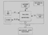
图1为系统整体框图;Figure 1 is the overall block diagram of the system;
图2(a)、(b)、(c)、(d)分别为INS系统、GPS系统、磁强计系统和气压计系统的结构图;Figure 2(a), (b), (c), and (d) are the structural diagrams of the INS system, GPS system, magnetometer system, and barometer system, respectively;
图3为导航计算机的结构图;Fig. 3 is the structural diagram of navigation computer;
图4为GPS/INS/磁强计/气压计的组合导航结算流程图;Fig. 4 is the integrated navigation settlement flow chart of GPS/INS/magnetometer/barometer;
图5为系统内部安装结构示意图;Figure 5 is a schematic diagram of the internal installation structure of the system;
图6为系统整体安装效果图。Figure 6 is the overall installation effect diagram of the system.
具体实施方式Detailed ways
下面结合附图对本发明作进一步更详细说明。The present invention will be described in further detail below in conjunction with the accompanying drawings.
参见附图1,为系统整体框图。整个组合导航系统由导航计算机融合GPS、INS、磁强计和气压计各子系统信息,通过多维拓展kalman滤波器输出载体的位置、速度和姿态信息。整个系统具有高度集成电路和独特安装结构的特点。See accompanying drawing 1, it is the overall block diagram of the system. The whole integrated navigation system uses the navigation computer to fuse the information of the subsystems of GPS, INS, magnetometer and barometer, and output the position, velocity and attitude information of the carrier through the multi-dimensional extended kalman filter. The whole system is characterized by a high degree of integrated circuits and a unique installation structure.
图2(a)所示INS子系统包括:三个单轴陀螺、两个双轴加速度计、温度传感器、运算放大器、A/D转换模块、SPI通讯接口。其中三个单轴陀螺用来测量载体的运动角速度;两个双轴的加速度计用来测量载体的线性加速度,其中在航向方向进行2个加速度差分处理;温度传感器3输出陀螺内部温度,用于对陀螺和加速度计进行温度补偿;所有的模拟信号经过运算放大器放大以后,通过16位A/D转换模块转变为数字信号,然后经过SPI通讯接口把INS系统所有数据传输到导航计算机进行处理。由于采用2个双轴MEMS加速度计,航向轴方向进行差分处理,以提高航向方向加速度精度。The INS subsystem shown in Figure 2(a) includes: three uniaxial gyroscopes, two biaxial accelerometers, temperature sensors, operational amplifiers, A/D conversion modules, and SPI communication interfaces. Three single-axis gyroscopes are used to measure the angular velocity of the carrier; two biaxial accelerometers are used to measure the linear acceleration of the carrier, and two acceleration differential processing is performed in the heading direction; the
图2(b)所示GPS子系统包括:GPS射频天线接收模块、GPS信号解算模块、RS-232标准通讯模块;其中通过GPS射频天线接收模块接收可见GPS导航卫星的信号,然后进入GPS信号解算模块,最后导航信息通过标准0183协议输出,然后通过RS-232通讯接口传输到导航计算机进行kalman组合导航算法融合。其中GPS信号解算模块主要采用瑞士U-blox公司提供的U-blox 5Q模块,该模块为多功能独立型GPS模块,以ROM为基础架构,成本低,体积小,该模块具有50个通道卫星接收功能,提供UART、USB、I2C、SPI数据接口,通过GPS接收天线接收GPS卫星的信号,然后在其内部解算出载体的位置、速度信息,以标准0183协议格式通过RS-232通信接口输出给微处理器,进行数据融合处理。The GPS subsystem shown in Figure 2(b) includes: GPS radio frequency antenna receiving module, GPS signal calculation module, RS-232 standard communication module; wherein the signal of visible GPS navigation satellites is received by the GPS radio frequency antenna receiving module, and then enters the GPS signal In the calculation module, the final navigation information is output through the standard 0183 protocol, and then transmitted to the navigation computer through the RS-232 communication interface for kalman integrated navigation algorithm fusion. Among them, the GPS signal calculation module mainly adopts the U-blox 5Q module provided by the Swiss U-blox company. This module is a multi-functional independent GPS module with ROM as the basic structure, low cost and small size. Receive function, provide UART, USB, I2C, SPI data interface, receive the signal of GPS satellite through GPS receiving antenna, then calculate the position and speed information of the carrier inside it, and output it to The microprocessor performs data fusion processing.
图3(c)所示磁强计子系统包括:一个三轴磁阻传感器、运算放大器模块、16位A/D转换模块;其中三维磁阻传感器输出三个轴向上磁场强度的模拟信号,经过运算放大器和16位A/D转换电路变换为数字信号;经由SPI通讯接口把磁强信息传输到导航计算机,该信息可用于初始对准和实时确定载体航向角。所述三轴磁阻传感器采用霍尼韦尔的三轴磁阻传感器,该传感器是一种小型3轴表面安装的传感器系统,它可在二高斯的量程内对磁场的测量灵敏度达到100微高斯。The magnetometer subsystem shown in Figure 3(c) includes: a three-axis magnetoresistive sensor, an operational amplifier module, and a 16-bit A/D conversion module; the three-dimensional magnetoresistive sensor outputs analog signals of magnetic field strength in three axial directions, It is transformed into a digital signal through an operational amplifier and a 16-bit A/D conversion circuit; the magnetic intensity information is transmitted to the navigation computer through the SPI communication interface, and the information can be used for initial alignment and real-time determination of the carrier's heading angle. The three-axis magnetoresistive sensor adopts Honeywell's three-axis magnetoresistive sensor, which is a small three-axis surface-mounted sensor system, which can measure the magnetic field with a sensitivity of 100 microgauss in the range of two Gauss .
图2(d)所示气压计子系统包括:大气压力传感器、I2C通信接口模块、高度解算模块;该大气压力传感器采用Bosch Sensortec公司的气压传感器,该传感器具有低电压供电、体积小、功耗低、气压测量精度高、测量范围宽等优点,可直接输出当前气压值的数字信息,经过标定、补偿和查表高度解算后通过I2C通讯接口传输到导航计算机内部,使用高度信息可以对系统的高度进行约束或者直接输出。The barometer subsystem shown in Figure 2(d) includes: an atmospheric pressure sensor, an I2C communication interface module, and an altitude calculation module; It has the advantages of low power consumption, high air pressure measurement accuracy, and wide measurement range. It can directly output the digital information of the current air pressure value. After calibration, compensation, and table look-up height calculation, it is transmitted to the navigation computer through the I2C communication interface. The height of the system is constrained or output directly.
图3所示导航计算机子系统包括:高速导航计算机、低压差稳压源模块;所述高速导航计算机可采用DSP或者ARM芯片来完成惯性器件的数据滤波和补偿算法、INS惯性测量单元的姿态解算和组合磁强计、气压计系统信息进行系统数据的融合算法;另外还可降低系统功耗、减小系统体积。该高速导航计算机通过SPI通讯接口接收INS的原始测量数据和磁强计系统数据、RS-232通讯接口接收GPS系统0183协议数据、I2C通讯接口接收气压数据,分别对各个子系统数据进行处理后再经过一个扩展kalman融合滤波器推算出实时具有高精度的载体速度、位置和姿态信息。整个系统可选择单独直接输出GPS子系统、INS子系统导航信息和气压计子系统测得的高度信息,进行冗余存储。低压差稳压源模块用来保证内部各系统供电的稳定性;该系统还加入了硬件高通和低通滤波器,来滤除电源交流部分和干扰成分。通过该子系统给陀螺、加速度计提供稳定的电压源来保证惯性器件的零位和标度因数等一系列参数的稳定性,从而进一步提高导航系统的整体精度。The navigation computer subsystem shown in Figure 3 includes: a high-speed navigation computer and a low-dropout voltage regulator module; the high-speed navigation computer can use DSP or ARM chips to complete the data filtering and compensation algorithms of inertial devices, and the attitude solution of INS inertial measurement units. Computing and combining magnetometer and barometer system information to carry out system data fusion algorithm; in addition, it can also reduce system power consumption and system volume. The high-speed navigation computer receives the original measurement data of the INS and the data of the magnetometer system through the SPI communication interface, the RS-232 communication interface receives the GPS system 0183 protocol data, and the I2C communication interface receives the air pressure data, and then processes the data of each subsystem respectively. After an extended kalman fusion filter, the real-time high-precision carrier velocity, position and attitude information is calculated. The entire system can choose to directly output the navigation information of the GPS subsystem, the INS subsystem and the altitude information measured by the barometer subsystem for redundant storage. The low-dropout regulated source module is used to ensure the stability of the power supply of each internal system; the system also adds hardware high-pass and low-pass filters to filter out the AC part and interference components of the power supply. The subsystem provides a stable voltage source for the gyroscope and accelerometer to ensure the stability of a series of parameters such as the zero position and scale factor of the inertial device, thereby further improving the overall accuracy of the navigation system.
图4所示组合导航系统的算法流程是:导航开始系统上电进行参数初始化;INS子系统开始输出角速度和加速度信息的数字信号,经过滑动平均和滤波处理,然后对此数据标定和温度补偿,导航计算机通过捷联导航算法求解出速度、位置和姿态信息;GPS子系统从上电时刻开始由射频天线接收当前可见GPS导航卫星信号,经过GPS信号解算模块处理后直接输出标准0183协议,传输到导航计算机内部,提取出载体的速度、位置和高度信息;磁强计子系统测得的磁场强度,经过干扰去除和标定补偿,再结合INS信息中的加速度信息可进行初始对准和载体的三维姿态计算;气压计子系统测得的高度值可抑制INS系统高度的发散和GPS高度的测量误差;所有上面子系统得到的数据通过系统kalman融合滤波解算出高精度的载体位置、速度和姿态信息进行输出,另通过滤波器估计出的陀螺和加速度计的随机常值漂移,可反馈校正INS系统。The algorithm flow of the integrated navigation system shown in Fig. 4 is as follows: at the beginning of navigation, the system is powered on to initialize the parameters; the INS subsystem starts to output the digital signals of angular velocity and acceleration information, which is processed by moving average and filtering, and then the data is calibrated and compensated for temperature. The navigation computer solves the speed, position and attitude information through the strapdown navigation algorithm; the GPS subsystem receives the currently visible GPS navigation satellite signals from the radio frequency antenna at the moment of power-on, and directly outputs the standard 0183 protocol after being processed by the GPS signal calculation module, and transmits Go to the interior of the navigation computer to extract the speed, position and height information of the carrier; the magnetic field strength measured by the magnetometer subsystem, after interference removal and calibration compensation, combined with the acceleration information in the INS information, can perform initial alignment and carrier alignment. Three-dimensional attitude calculation; the altitude value measured by the barometer subsystem can suppress the divergence of the INS system altitude and the measurement error of the GPS altitude; all the data obtained by the above subsystems can be solved by the system kalman fusion filter to calculate the high-precision carrier position, velocity and attitude The information is output, and the random constant drift of the gyroscope and accelerometer estimated by the filter can be fed back to correct the INS system.
如图5所示,本发明采用高集成度但布局合理的电路设计以减小各子系统器件之间的电磁干扰、相互发热影响和降低系统体积。GPS系统1采用单独供电并放置在一块上层PCB板上以减小对其他子系统的电磁干扰和搜星过程中电流波动对系统A/D采集带来的干扰;对INS子系统的单轴陀螺2和双轴加速度计3提供单独参考电压以提高精度;4为磁强计子系统;5为气压计子系统;6为导航计算机子系统;整个系统的低压差稳压源模块7远离惯测量性器件和磁强计以最大程度上减小热量散发对器件造成零偏影响。本发明采用了独特巧妙的硬件安装结构设计:上下两层之间的连接固定部件8用以加固两层PCB板的连接强度;9所示为系统所有的五块PCB板相对位置示意图,其中上下两层PCB板通过插接件连接和固定部件8进行固定,中间三小块PCB板分别通过开槽处理保证相互正交安装在底板上,三个单轴陀螺2和两个双轴加速度计3分别设置在上述三小块PCB板上,其余部件均设置在下层PCB板上;整个系统的每个PCB板均采用高集成度的四层电路;该安装结构可使导航计算机、电源模块、A/D模块、单轴陀螺2、双轴加速度计3、磁强计4和气压计子系统5合理的分布PCB板上,最大程度利用了内部空间从而大大减小了系统体积;其中由于硬件安装结构使陀螺和加速度计分别呈现正交的结果,大大降低了后期软件补偿带来的误差;电磁兼容性强,并且设计有减震系统可抗较大冲击。As shown in FIG. 5 , the present invention adopts a highly integrated circuit design with a reasonable layout to reduce electromagnetic interference, mutual heating effect and system volume among subsystem components. GPS system 1 uses a separate power supply and is placed on an upper PCB board to reduce electromagnetic interference to other subsystems and interference to system A/D acquisition caused by current fluctuations in the satellite search process; single-axis gyroscope for
如图6所示,为系统的整体安装效果图。其中10为Φ3mm螺钉固定孔;11为GPS天线接口;12为四端子航空接插件接口,负责电源供电和信号传输;13为安装基准面,以保证安装误差。最终大小尺寸为:49mm*36mm*28mm。As shown in Figure 6, it is the overall installation effect diagram of the system. Among them, 10 is the Φ3mm screw fixing hole; 11 is the GPS antenna interface; 12 is the four-terminal aviation connector interface, which is responsible for power supply and signal transmission; 13 is the installation reference plane to ensure the installation error. The final size is: 49mm*36mm*28mm.
总的来说,本发明采用独特的硬件结构设计,集成了GPS、INS、磁强计、气压计、低压差稳压源、运算放大器、16位A/D采集、导航计算机系统,整体系统结构体积小、功耗低;内部组合算法使用了松组合算法,各个子系统可以独立工作,提高了整个系统的可靠性,具有冗余性的特点;该系统可使用RS-232、RS-422协议通讯具有兼容性,系统响应速度快、精度高、成本低,可用于低成本需要一定精度的导航系统,特别适用于路用车辆、小型机器人、小型飞行器等载重能力小,使用电池供电的系统。In general, the present invention adopts a unique hardware structure design, integrates GPS, INS, magnetometer, barometer, low dropout voltage regulator, operational amplifier, 16-bit A/D acquisition, navigation computer system, and the overall system structure Small size and low power consumption; the internal combination algorithm uses a loose combination algorithm, and each subsystem can work independently, which improves the reliability of the entire system and has the characteristics of redundancy; the system can use RS-232, RS-422 protocols The communication is compatible, the system has fast response speed, high precision, and low cost. It can be used for low-cost navigation systems that require certain precision, especially for road vehicles, small robots, and small aircrafts with low load capacity and battery-powered systems.
Claims (6)
Priority Applications (1)
| Application Number | Priority Date | Filing Date | Title |
|---|---|---|---|
| CN201210366449.0ACN102879793B (en) | 2012-09-28 | 2012-09-28 | Super-miniature GPS (global positioning system), INS (inertial navigation system), magnetometer and barometer integrated navigation system |
Applications Claiming Priority (1)
| Application Number | Priority Date | Filing Date | Title |
|---|---|---|---|
| CN201210366449.0ACN102879793B (en) | 2012-09-28 | 2012-09-28 | Super-miniature GPS (global positioning system), INS (inertial navigation system), magnetometer and barometer integrated navigation system |
Publications (2)
| Publication Number | Publication Date |
|---|---|
| CN102879793Atrue CN102879793A (en) | 2013-01-16 |
| CN102879793B CN102879793B (en) | 2014-07-23 |
Family
ID=47481187
Family Applications (1)
| Application Number | Title | Priority Date | Filing Date |
|---|---|---|---|
| CN201210366449.0AExpired - Fee RelatedCN102879793B (en) | 2012-09-28 | 2012-09-28 | Super-miniature GPS (global positioning system), INS (inertial navigation system), magnetometer and barometer integrated navigation system |
Country Status (1)
| Country | Link |
|---|---|
| CN (1) | CN102879793B (en) |
Cited By (33)
| Publication number | Priority date | Publication date | Assignee | Title |
|---|---|---|---|---|
| CN103116175A (en)* | 2013-01-18 | 2013-05-22 | 东南大学 | Embedded type navigation information processor based on DSP (digital signal processor) and FPGA (field programmable gata array) |
| CN103217700A (en)* | 2013-04-10 | 2013-07-24 | 南昌大学 | GPS (global positioning system), IMU (inertial measurement unit), magnetometer and barometer combinational navigation system device |
| CN103940425A (en)* | 2014-04-22 | 2014-07-23 | 北京信息科技大学 | Magnetic-inertial combination strapdown measuring method |
| CN104251699A (en)* | 2013-06-27 | 2014-12-31 | 珠海世纪鼎利通信科技股份有限公司 | Indoor space positioning equipment and positioning method thereof |
| CN104251999A (en)* | 2013-06-27 | 2014-12-31 | 珠海世纪鼎利通信科技股份有限公司 | Indoor positioning equipment and method |
| CN104569958A (en)* | 2013-10-18 | 2015-04-29 | 中国科学院上海高等研究院 | Target positioning method and system based on ultrasonic wave and inertial navigation combination |
| CN104914271A (en)* | 2014-03-13 | 2015-09-16 | 波音公司 | Airspeed calculation system for aircraft |
| CN105021183A (en)* | 2015-07-05 | 2015-11-04 | 电子科技大学 | Low-cost GPS and INS integrated navigation system for multi-rotor aircrafts |
| CN105157706A (en)* | 2015-08-25 | 2015-12-16 | 武汉易得路位置科技有限公司 | WiFi hotspot position measuring method based on multi-sensor information |
| CN105333870A (en)* | 2015-12-15 | 2016-02-17 | 中国电子科技集团公司第二十六研究所 | Miniature compound navigation circuit |
| CN105352502A (en)* | 2015-11-26 | 2016-02-24 | 湖北三江航天红峰控制有限公司 | Attitude obtaining method of micro-inertia sailing attitude reference system |
| CN105466423A (en)* | 2016-01-11 | 2016-04-06 | 致导科技(北京)有限公司 | Unmanned aerial vehicle navigation system and operation method thereof |
| CN105607093A (en)* | 2015-12-20 | 2016-05-25 | 上海华测导航技术股份有限公司 | Integrated navigation system and method for acquiring navigation coordinate |
| CN105807303A (en)* | 2016-05-14 | 2016-07-27 | 中卫物联成都科技有限公司 | Integrated navigation method and device based on GNSS, INS and airborne altimeter |
| CN105841699A (en)* | 2016-03-28 | 2016-08-10 | 北京航空航天大学 | Radar altimeter assistance method aiming to inertial navigation |
| CN106441294A (en)* | 2016-11-07 | 2017-02-22 | 北京耘华科技有限公司 | MEMS inertial integrated measuring module |
| CN106768549A (en)* | 2016-12-12 | 2017-05-31 | 北京信息科技大学 | A kind of high dynamic carrier environment force measuring device |
| CN106840203A (en)* | 2017-01-10 | 2017-06-13 | 南京航空航天大学 | Barometertic altimeter bearing calibration in inertial navigation/barometertic altimeter/GPS integrated navigation systems |
| CN108333605A (en)* | 2017-12-29 | 2018-07-27 | 武汉理工大学 | A kind of ship navigation shunting judgment method and system based on Differential positioning |
| CN108731664A (en)* | 2018-05-18 | 2018-11-02 | 深圳清创新科技有限公司 | Robotary method of estimation, device, computer equipment and storage medium |
| CN108957513A (en)* | 2018-05-17 | 2018-12-07 | 北京航空航天大学 | A kind of microminiature position attitude measurement system |
| CN108981708A (en)* | 2018-08-02 | 2018-12-11 | 南京航空航天大学 | Quadrotor torque model/directional gyro/Magnetic Sensor fault-tolerance combined navigation method |
| CN109443385A (en)* | 2018-11-13 | 2019-03-08 | 中国兵器装备集团自动化研究所 | A kind of inertial navigation installation error automatic calibration method of antenna for satellite communication in motion |
| CN110174902A (en)* | 2019-05-22 | 2019-08-27 | 长光卫星技术有限公司 | Magnetometer/MEMS gyroscope combination system for microsatellite |
| CN111366151A (en)* | 2018-12-26 | 2020-07-03 | 北京信息科技大学 | Information fusion method for ship navigation in polar region |
| CN111966123A (en)* | 2020-08-28 | 2020-11-20 | 北京信息科技大学 | Navigation equipment and aircraft |
| CN111982106A (en)* | 2020-08-28 | 2020-11-24 | 北京信息科技大学 | Navigation method, navigation device, storage medium and electronic device |
| CN112255624A (en)* | 2020-09-30 | 2021-01-22 | 湖南航天机电设备与特种材料研究所 | A high-precision horizontal attitude measurement method and system |
| CN112577484A (en)* | 2019-09-29 | 2021-03-30 | 北京信息科技大学 | Telemetering device applied to small meteorological detection equipment |
| WO2021208190A1 (en)* | 2020-04-14 | 2021-10-21 | 上海华测导航技术股份有限公司 | Navigation board, multi-source data fusion method for navigation board, and carrier |
| CN113984049A (en)* | 2021-11-30 | 2022-01-28 | 北京信息科技大学 | Method, device and system for estimating flight trajectory of aircraft |
| CN115202271A (en)* | 2022-08-23 | 2022-10-18 | 南京理工大学 | A Micro-UAV Embedded Flight Controller |
| CN115752471A (en)* | 2022-11-17 | 2023-03-07 | 亿航智能设备(广州)有限公司 | Sensor data processing method and device and computer readable storage medium |
Citations (4)
| Publication number | Priority date | Publication date | Assignee | Title |
|---|---|---|---|---|
| US6427122B1 (en)* | 2000-12-23 | 2002-07-30 | American Gnc Corporation | Positioning and data integrating method and system thereof |
| CN101000244A (en)* | 2007-01-05 | 2007-07-18 | 北京航空航天大学 | High integral navigation device combined by MIMU/GPS/micromagnetic compass/barometric altimeter |
| CN101319902A (en)* | 2008-07-18 | 2008-12-10 | 哈尔滨工程大学 | A low-cost combined positioning and orientation device and combined positioning method |
| CN102353970A (en)* | 2011-06-10 | 2012-02-15 | 北京航空航天大学 | GPS/SINS (global positioning system/strapdown inertial navigation system) combined navigating system with high anti-interference performance and realizing method thereof |
- 2012
- 2012-09-28CNCN201210366449.0Apatent/CN102879793B/ennot_activeExpired - Fee Related
Patent Citations (4)
| Publication number | Priority date | Publication date | Assignee | Title |
|---|---|---|---|---|
| US6427122B1 (en)* | 2000-12-23 | 2002-07-30 | American Gnc Corporation | Positioning and data integrating method and system thereof |
| CN101000244A (en)* | 2007-01-05 | 2007-07-18 | 北京航空航天大学 | High integral navigation device combined by MIMU/GPS/micromagnetic compass/barometric altimeter |
| CN101319902A (en)* | 2008-07-18 | 2008-12-10 | 哈尔滨工程大学 | A low-cost combined positioning and orientation device and combined positioning method |
| CN102353970A (en)* | 2011-06-10 | 2012-02-15 | 北京航空航天大学 | GPS/SINS (global positioning system/strapdown inertial navigation system) combined navigating system with high anti-interference performance and realizing method thereof |
Non-Patent Citations (1)
| Title |
|---|
| 苏中; 徐大为; 康春鹏: "基于GPS/INS导航系统的高速卡尔曼滤波算法研究", 《仪器仪表学报》* |
Cited By (47)
| Publication number | Priority date | Publication date | Assignee | Title |
|---|---|---|---|---|
| CN103116175B (en)* | 2013-01-18 | 2015-06-03 | 东南大学 | Embedded type navigation information processor based on DSP (digital signal processor) and FPGA (field programmable gata array) |
| CN103116175A (en)* | 2013-01-18 | 2013-05-22 | 东南大学 | Embedded type navigation information processor based on DSP (digital signal processor) and FPGA (field programmable gata array) |
| CN103217700A (en)* | 2013-04-10 | 2013-07-24 | 南昌大学 | GPS (global positioning system), IMU (inertial measurement unit), magnetometer and barometer combinational navigation system device |
| CN104251699A (en)* | 2013-06-27 | 2014-12-31 | 珠海世纪鼎利通信科技股份有限公司 | Indoor space positioning equipment and positioning method thereof |
| CN104251999A (en)* | 2013-06-27 | 2014-12-31 | 珠海世纪鼎利通信科技股份有限公司 | Indoor positioning equipment and method |
| CN104251699B (en)* | 2013-06-27 | 2017-02-15 | 珠海世纪鼎利科技股份有限公司 | Indoor space positioning method |
| CN104569958A (en)* | 2013-10-18 | 2015-04-29 | 中国科学院上海高等研究院 | Target positioning method and system based on ultrasonic wave and inertial navigation combination |
| CN104914271A (en)* | 2014-03-13 | 2015-09-16 | 波音公司 | Airspeed calculation system for aircraft |
| CN104914271B (en)* | 2014-03-13 | 2020-01-14 | 波音公司 | Airspeed calculation system and method for determining airspeed of an aircraft |
| CN103940425A (en)* | 2014-04-22 | 2014-07-23 | 北京信息科技大学 | Magnetic-inertial combination strapdown measuring method |
| CN103940425B (en)* | 2014-04-22 | 2017-03-01 | 北京信息科技大学 | A kind of magnetic inertia combines Strapdown inertial measurement method |
| CN105021183A (en)* | 2015-07-05 | 2015-11-04 | 电子科技大学 | Low-cost GPS and INS integrated navigation system for multi-rotor aircrafts |
| CN105157706A (en)* | 2015-08-25 | 2015-12-16 | 武汉易得路位置科技有限公司 | WiFi hotspot position measuring method based on multi-sensor information |
| CN105352502A (en)* | 2015-11-26 | 2016-02-24 | 湖北三江航天红峰控制有限公司 | Attitude obtaining method of micro-inertia sailing attitude reference system |
| CN105333870B (en)* | 2015-12-15 | 2018-06-08 | 中国电子科技集团公司第二十六研究所 | A kind of miniature complex navigation circuit |
| CN105333870A (en)* | 2015-12-15 | 2016-02-17 | 中国电子科技集团公司第二十六研究所 | Miniature compound navigation circuit |
| CN105607093A (en)* | 2015-12-20 | 2016-05-25 | 上海华测导航技术股份有限公司 | Integrated navigation system and method for acquiring navigation coordinate |
| CN105607093B (en)* | 2015-12-20 | 2018-05-08 | 上海华测导航技术股份有限公司 | A kind of integrated navigation system and the method for obtaining navigation coordinate |
| CN105466423A (en)* | 2016-01-11 | 2016-04-06 | 致导科技(北京)有限公司 | Unmanned aerial vehicle navigation system and operation method thereof |
| CN105841699A (en)* | 2016-03-28 | 2016-08-10 | 北京航空航天大学 | Radar altimeter assistance method aiming to inertial navigation |
| CN105807303B (en)* | 2016-05-14 | 2018-12-21 | 中卫物联成都科技有限公司 | Combinated navigation method and equipment based on GNSS, INS and airborne altimeter |
| CN105807303A (en)* | 2016-05-14 | 2016-07-27 | 中卫物联成都科技有限公司 | Integrated navigation method and device based on GNSS, INS and airborne altimeter |
| CN106441294A (en)* | 2016-11-07 | 2017-02-22 | 北京耘华科技有限公司 | MEMS inertial integrated measuring module |
| CN106768549A (en)* | 2016-12-12 | 2017-05-31 | 北京信息科技大学 | A kind of high dynamic carrier environment force measuring device |
| CN106840203A (en)* | 2017-01-10 | 2017-06-13 | 南京航空航天大学 | Barometertic altimeter bearing calibration in inertial navigation/barometertic altimeter/GPS integrated navigation systems |
| CN106840203B (en)* | 2017-01-10 | 2020-01-17 | 南京航空航天大学 | Calibration method of barometric altimeter in inertial navigation/barometric altimeter/GPS integrated navigation system |
| CN108333605A (en)* | 2017-12-29 | 2018-07-27 | 武汉理工大学 | A kind of ship navigation shunting judgment method and system based on Differential positioning |
| CN108957513A (en)* | 2018-05-17 | 2018-12-07 | 北京航空航天大学 | A kind of microminiature position attitude measurement system |
| CN108731664A (en)* | 2018-05-18 | 2018-11-02 | 深圳清创新科技有限公司 | Robotary method of estimation, device, computer equipment and storage medium |
| CN108731664B (en)* | 2018-05-18 | 2020-08-11 | 深圳一清创新科技有限公司 | Robot state estimation method, device, computer equipment and storage medium |
| CN108981708B (en)* | 2018-08-02 | 2021-10-19 | 南京航空航天大学 | Four-rotor torque model/heading gyro/magnetic sensor fault-tolerant integrated navigation method |
| CN108981708A (en)* | 2018-08-02 | 2018-12-11 | 南京航空航天大学 | Quadrotor torque model/directional gyro/Magnetic Sensor fault-tolerance combined navigation method |
| CN109443385A (en)* | 2018-11-13 | 2019-03-08 | 中国兵器装备集团自动化研究所 | A kind of inertial navigation installation error automatic calibration method of antenna for satellite communication in motion |
| CN109443385B (en)* | 2018-11-13 | 2022-07-29 | 中国兵器装备集团自动化研究所有限公司 | Inertial navigation installation error automatic calibration method of communication-in-moving antenna |
| CN111366151A (en)* | 2018-12-26 | 2020-07-03 | 北京信息科技大学 | Information fusion method for ship navigation in polar region |
| CN110174902B (en)* | 2019-05-22 | 2022-01-28 | 长光卫星技术有限公司 | magnetometer/MEMS gyroscope combination system for microsatellite |
| CN110174902A (en)* | 2019-05-22 | 2019-08-27 | 长光卫星技术有限公司 | Magnetometer/MEMS gyroscope combination system for microsatellite |
| CN112577484A (en)* | 2019-09-29 | 2021-03-30 | 北京信息科技大学 | Telemetering device applied to small meteorological detection equipment |
| WO2021208190A1 (en)* | 2020-04-14 | 2021-10-21 | 上海华测导航技术股份有限公司 | Navigation board, multi-source data fusion method for navigation board, and carrier |
| US11789163B2 (en) | 2020-04-14 | 2023-10-17 | Shanghai Huace Navigation Technology Ltd | Navigation board, multi-source data fusion method for navigation board and transporter |
| CN111982106A (en)* | 2020-08-28 | 2020-11-24 | 北京信息科技大学 | Navigation method, navigation device, storage medium and electronic device |
| CN111966123A (en)* | 2020-08-28 | 2020-11-20 | 北京信息科技大学 | Navigation equipment and aircraft |
| CN112255624A (en)* | 2020-09-30 | 2021-01-22 | 湖南航天机电设备与特种材料研究所 | A high-precision horizontal attitude measurement method and system |
| CN113984049A (en)* | 2021-11-30 | 2022-01-28 | 北京信息科技大学 | Method, device and system for estimating flight trajectory of aircraft |
| CN113984049B (en)* | 2021-11-30 | 2024-01-26 | 北京信息科技大学 | Method, device and system for estimating flight trajectory of aircraft |
| CN115202271A (en)* | 2022-08-23 | 2022-10-18 | 南京理工大学 | A Micro-UAV Embedded Flight Controller |
| CN115752471A (en)* | 2022-11-17 | 2023-03-07 | 亿航智能设备(广州)有限公司 | Sensor data processing method and device and computer readable storage medium |
Also Published As
| Publication number | Publication date |
|---|---|
| CN102879793B (en) | 2014-07-23 |
Similar Documents
| Publication | Publication Date | Title |
|---|---|---|
| CN102879793B (en) | Super-miniature GPS (global positioning system), INS (inertial navigation system), magnetometer and barometer integrated navigation system | |
| CN100419380C (en) | A highly integrated MIMU/GPS/micromagnetic compass/barometric altimeter integrated navigation system | |
| CN102980577B (en) | Micro-strapdown altitude heading reference system and working method thereof | |
| CN102445200B (en) | Microminiature personal combined navigation system as well as navigating and positioning method thereof | |
| CN201266089Y (en) | INS/GPS combined navigation system | |
| CN104698485B (en) | Integrated navigation system and air navigation aid based on BD, GPS and MEMS | |
| CN202904027U (en) | Autonomous indoor positioning system | |
| CN107655476A (en) | Pedestrian's high accuracy foot navigation algorithm based on Multi-information acquisition compensation | |
| CN201561759U (en) | Inertial attitude and azimuth measuring device | |
| CN105571591A (en) | Multi-information deep integration navigation micro-system and navigation method | |
| CN108225313B (en) | Attitude Meter Based on Redundant MEMS Sensors | |
| CN101865693A (en) | Aviation multi-sensor integrated navigation system | |
| CN111781624B (en) | Universal integrated navigation system and method | |
| CN102590842B (en) | GNSS/IMU (global navigation satellite system/inertial measurement unit) integrated antenna | |
| CN104181573A (en) | Beidou inertial navigation deep integration navigation microsystem | |
| CN103017764A (en) | Autonomous navigation and attitude measurement device for high speed train | |
| CN114518587B (en) | Indoor and outdoor seamless positioning system and method | |
| CN111366143A (en) | Combined polar region compass device capable of automatically positioning and orienting | |
| Fontanella et al. | Advanced low-cost integrated inertial systems with multiple consumer grade sensors | |
| CN201397343Y (en) | Inertial measurement device | |
| CN204788412U (en) | Inertial sensor subassembly suitable for small -size unmanned helicopter | |
| CN202057801U (en) | Combined positioning device based on BD, GPS and DR | |
| CN117470231A (en) | Intelligent network allies oneself with high accuracy navigation equipment based on optic fibre is used to guide | |
| CN116660579A (en) | Wind speed data correction method, system and device | |
| CN115683096A (en) | Integrated navigation and positioning system with single-axis fiber optic gyroscope set on the Z axis |
Legal Events
| Date | Code | Title | Description |
|---|---|---|---|
| C06 | Publication | ||
| PB01 | Publication | ||
| C10 | Entry into substantive examination | ||
| SE01 | Entry into force of request for substantive examination | ||
| C14 | Grant of patent or utility model | ||
| GR01 | Patent grant | ||
| CF01 | Termination of patent right due to non-payment of annual fee | Granted publication date:20140723 | |
| CF01 | Termination of patent right due to non-payment of annual fee |