CN102759738A - Navigation system and method thereof - Google Patents
Navigation system and method thereofDownload PDFInfo
- Publication number
- CN102759738A CN102759738ACN2011101066712ACN201110106671ACN102759738ACN 102759738 ACN102759738 ACN 102759738ACN 2011101066712 ACN2011101066712 ACN 2011101066712ACN 201110106671 ACN201110106671 ACN 201110106671ACN 102759738 ACN102759738 ACN 102759738A
- Authority
- CN
- China
- Prior art keywords
- information
- terminal transceiver
- road area
- communication station
- area communication
- Prior art date
- Legal status (The legal status is an assumption and is not a legal conclusion. Google has not performed a legal analysis and makes no representation as to the accuracy of the status listed.)
- Pending
Links
- 238000000034methodMethods0.000titledescription19
- 238000004891communicationMethods0.000claimsabstractdescription73
- 230000006870functionEffects0.000claimsdescription17
- 230000003993interactionEffects0.000claimsdescription3
- 238000012423maintenanceMethods0.000claims4
- 230000002123temporal effectEffects0.000claims2
- 238000010586diagramMethods0.000description9
- 238000004364calculation methodMethods0.000description6
- 238000005516engineering processMethods0.000description4
- 230000007812deficiencyEffects0.000description2
- 238000007726management methodMethods0.000description2
- 238000012545processingMethods0.000description2
- 230000003068static effectEffects0.000description2
- 239000012141concentrateSubstances0.000description1
- 230000000694effectsEffects0.000description1
- 230000007613environmental effectEffects0.000description1
- 238000012905input functionMethods0.000description1
- 230000010354integrationEffects0.000description1
- 238000004519manufacturing processMethods0.000description1
- 238000012986modificationMethods0.000description1
- 230000004048modificationEffects0.000description1
- 230000003287optical effectEffects0.000description1
- 230000008569processEffects0.000description1
- 230000009466transformationEffects0.000description1
- XLYOFNOQVPJJNP-UHFFFAOYSA-NwaterSubstancesOXLYOFNOQVPJJNP-UHFFFAOYSA-N0.000description1
Images


Landscapes
- Navigation (AREA)
- Traffic Control Systems (AREA)
Abstract
Translated fromChinese
Description
Translated fromChinese技术领域technical field
本发明涉及卫星定位与导航通信领域,具体而言,本发明导航系统及其方法。The invention relates to the field of satellite positioning and navigation communication, in particular, the navigation system and method of the invention.
背景技术Background technique
目前,城市的机动车保有量持续大幅增长,城市交通状况不容乐观。道路拥堵已经成为影响群众日常生活的一个难题。为了改善交通状况,各主要城市都成立了交通指挥中心。在城市的主要道路上设置摄像头来获取各个路段的实时路况,并通过电子显示屏、广播等方式发布路况信息,指导机动车合理选择出行路线,以取得疏导交通的目的。At present, the number of motor vehicles in cities continues to increase significantly, and the urban traffic situation is not optimistic. Road congestion has become a difficult problem affecting people's daily life. In order to improve traffic conditions, traffic command centers have been established in major cities. Set up cameras on the main roads of the city to obtain real-time road conditions of each road section, and release road condition information through electronic display screens, broadcasts, etc., to guide motor vehicles to choose travel routes reasonably, so as to achieve the purpose of traffic relief.
但是,上述的交通指挥管理方式是一种粗放式的指挥方式,有着种种不足:However, the above-mentioned traffic command and management method is an extensive command method with various deficiencies:
首先,目前的交通指挥方法,目标是保证道路通畅。所以,其监控道路,并发布路况信息,希望机动车不要集中出现在某个路段上。而机动车驾驶员的出行目的是达到目的地。现有的交通指挥系统,采用广播的方式发布路况信息,不能针对性的向每个机动车驾驶员提供快捷的到达目的地的路线。First of all, the current traffic command method, the goal is to ensure smooth roads. Therefore, it monitors the road and releases road condition information, hoping that motor vehicles will not concentrate on a certain road section. The travel purpose of the motor vehicle driver is to reach the destination. The existing traffic command system uses broadcasting to release road condition information, and cannot provide each motor vehicle driver with a fast route to the destination.
其次,目前的交通指挥方法,只是在主要道路,比如环线、干线、联络线上才设置的摄像头,其不能获取整个城市的实时交通状况。Secondly, the current traffic command method is only a camera that is set on major roads, such as ring roads, trunk lines, and tie lines, which cannot obtain real-time traffic conditions in the entire city.
第三,通过摄像头看到的是道路上车辆数目和拥堵情况,不仅不能对路况进行预测,还具有一定的延迟性。所以,当看到道路已经堵塞的时候,再进行交通疏导,其效果并不理想。Third, what the camera sees is the number of vehicles on the road and the congestion situation, which not only cannot predict the road conditions, but also has a certain delay. Therefore, when it is seen that the road is blocked, the effect of traffic relief is not ideal.
最后,现有的交通指挥系统,发布信息的手段和方式有限,并不能及时准确的将信息发布给每一个需要的机动车驾驶员。Finally, the existing traffic command system has limited means and methods of disseminating information, and cannot timely and accurately disseminate information to every motor vehicle driver who needs it.
正是因为存在着上述的不足,现有的交通指挥系统并不能胜任城市交通和机动车驾驶员指导的任务。Exactly because of the above-mentioned deficiencies, the existing traffic command system is not up to the task of guiding urban traffic and motor vehicle drivers.
因此,有必要提出有效可行的技术方案解决上述问题。Therefore, it is necessary to propose effective and feasible technical solutions to solve the above problems.
发明内容Contents of the invention
本发明的目的旨在至少解决上述技术问题之一,特别是通过卫星定位和导航技术,通过导航中心平台更新维护城市交通地图信息,实现城市交通导航疏导。The purpose of the present invention is to at least solve one of the above-mentioned technical problems, especially through satellite positioning and navigation technology, update and maintain urban traffic map information through the navigation center platform, and realize urban traffic navigation and guidance.
本发明实施例一方面提出了一种导航系统,包括安装在车辆上的终端收发机、道路区域通信站以及导航中心平台,Embodiments of the present invention provide a navigation system on the one hand, including a terminal transceiver installed on a vehicle, a road area communication station, and a navigation center platform,
所述终端收发机,用于接收卫星信号,具有卫星定位功能,以及与所述道路区域通信站进行通信,获取线路信息;The terminal transceiver is used to receive satellite signals, has a satellite positioning function, and communicates with the road area communication station to obtain line information;
所述道路区域通信站,用于与所述终端收发机通信,交互所述终端收发机的位置信息以及线路信息,并将所述位置信息和线路信息转发给所述导航中心平台;The road area communication station is used to communicate with the terminal transceiver, exchange the location information and line information of the terminal transceiver, and forward the location information and line information to the navigation center platform;
所述导航中心平台,具有城市交通地图信息,用于根据所述终端收发机提供的所述位置信息和线路信息,计算线路信息后经过所述道路区域通信站提供给所述终端收发机。The navigation center platform has city traffic map information, which is used to calculate route information based on the location information and route information provided by the terminal transceiver and provide it to the terminal transceiver via the road area communication station.
本发明实施例另一方面提出了一种导航方法,包括以下步骤:Another aspect of the embodiment of the present invention provides a navigation method, including the following steps:
安装在车辆上的终端收发机接收卫星信号,确定所述终端收发机的位置信息及线路信息;The terminal transceiver installed on the vehicle receives satellite signals, and determines the position information and line information of the terminal transceiver;
所述终端收发机将所述位置信息及线路信息与道路区域通信站进行交换,经所述道路区域通信站将所述位置信息及线路信息传送至导航中心平台;The terminal transceiver exchanges the location information and line information with the road area communication station, and transmits the location information and line information to the navigation center platform through the road area communication station;
所述导航中心平台根据所述终端收发机提供的信息,计算线路信息后经所述道路区域通信站提供给所述终端收发机。The navigation center platform calculates line information according to the information provided by the terminal transceiver and provides it to the terminal transceiver via the road area communication station.
本发明提出的上述方案,考虑到每一个机动车驾驶员的出行需求,通过导航中心平台为其设计出线路信息,保证了机动车驾驶员快捷的到达目的地,也能够最大程度的保证道路通畅。另外,本发明提出的终端机可以安装在每一辆机动车上,克服了摄像头不能移动的特点,能够获取更完整的城市交通状况。同时,本发明提出的终端机能够发送包括时间、速度在内的信息,因此,导航中心平台可以获知道路的平均时速,可以更为准确的进行导航。The above solution proposed by the present invention takes into account the travel needs of each motor vehicle driver, and designs route information for it through the navigation center platform, which ensures that the motor vehicle driver can reach the destination quickly and can also ensure the smoothest roads to the greatest extent. . In addition, the terminal machine proposed by the present invention can be installed on every motor vehicle, overcomes the feature that the camera cannot be moved, and can obtain a more complete urban traffic situation. At the same time, the terminal proposed by the present invention can send information including time and speed. Therefore, the navigation center platform can obtain the average speed per hour of the road, and can navigate more accurately.
本发明附加的方面和优点将在下面的描述中部分给出,部分将从下面的描述中变得明显,或通过本发明的实践了解到。Additional aspects and advantages of the invention will be set forth in part in the description which follows, and in part will be obvious from the description, or may be learned by practice of the invention.
附图说明Description of drawings
本发明上述的和/或附加的方面和优点从下面结合附图对实施例的描述中将变得明显和容易理解,其中:The above and/or additional aspects and advantages of the present invention will become apparent and easy to understand from the following description of the embodiments in conjunction with the accompanying drawings, wherein:
图1为本发明实施例导航系统示意图;Fig. 1 is the schematic diagram of the navigation system of the embodiment of the present invention;
图2为本发明实施例终端机的结构示意图;FIG. 2 is a schematic structural diagram of a terminal according to an embodiment of the present invention;
图3为本发明实施例导航中心平台的功能示意图;Fig. 3 is the functional schematic diagram of the navigation center platform of the embodiment of the present invention;
图4为本发明实施例城市交通地图信息表;Fig. 4 is the urban traffic map information table of the embodiment of the present invention;
图5为本发明实施例导航方法流程图;FIG. 5 is a flowchart of a navigation method according to an embodiment of the present invention;
图6为本发明实施例导航方法功能框图;6 is a functional block diagram of a navigation method according to an embodiment of the present invention;
图7为本发明实施例城市交通地图更新方法流程图;FIG. 7 is a flowchart of a method for updating an urban traffic map according to an embodiment of the present invention;
图8为本发明实施例城市导航流程图。Fig. 8 is a flow chart of city navigation according to an embodiment of the present invention.
具体实施方式Detailed ways
下面详细描述本发明的实施例,所述实施例的示例在附图中示出,其中自始至终相同或类似的标号表示相同或类似的元件或具有相同或类似功能的元件。下面通过参考附图描述的实施例是示例性的,仅用于解释本发明,而不能解释为对本发明的限制。Embodiments of the present invention are described in detail below, examples of which are shown in the drawings, wherein the same or similar reference numerals designate the same or similar elements or elements having the same or similar functions throughout. The embodiments described below by referring to the figures are exemplary only for explaining the present invention and should not be construed as limiting the present invention.
现有的导航技术,主要是通过接收卫星信号,解算得到时间和位置信息,并结合地图信息,能够根据机动车驾驶员的设定,自动计算得到从出发点到目的地的静态路径。其主要不足包括,静态的计算路径,不能根据路况信息进行动态调整。Existing navigation technology mainly obtains time and location information by receiving satellite signals, combined with map information, and can automatically calculate the static path from the starting point to the destination according to the settings of the motor vehicle driver. Its main shortcomings include that the static calculation path cannot be dynamically adjusted according to road condition information.
物联网是把新一代IT技术充分运用在各行各业之中,具体地说,就是把感应器嵌入和装备到电网、铁路、桥梁、隧道、建筑、大坝、供水系统、油气管道等各种物体中,然后将“物联网”与现有的通信网整合起来,实现人类社会与物理系统的整合,能够对整合网络内的人员、机器、设备和基础设施实施实时的管理和控制。在此基础上,人类可以以更加精细和动态的方式管理生产和生活,达到“智慧”状态,提高资源利用率和生产力水平,改善人与自然间的关系。利用物联网技术可以实现医疗、物流、环保、交通等领域的智能化改造。The Internet of Things is to fully apply the new generation of IT technology in all walks of life. Specifically, it is to embed and equip sensors into power grids, railways, bridges, tunnels, buildings, dams, water supply systems, oil and gas pipelines, etc. Objects, and then integrate the "Internet of Things" with the existing communication network to realize the integration of human society and physical systems, and implement real-time management and control of personnel, machines, equipment and infrastructure in the integrated network. On this basis, humans can manage production and life in a more refined and dynamic manner, achieve a state of "smartness", improve resource utilization and productivity levels, and improve the relationship between humans and nature. The use of Internet of Things technology can realize the intelligent transformation of medical care, logistics, environmental protection, transportation and other fields.
本发明就提出了一种基于物联网的最短时间导航系统和方法。为了实现本发明之目的,本发明提出了一种导航系统,包括安装在车辆上的终端收发机、道路区域通信站以及导航中心平台,The present invention proposes a minimum time navigation system and method based on the Internet of Things. In order to achieve the purpose of the present invention, the present invention proposes a navigation system, including a terminal transceiver installed on a vehicle, a road area communication station and a navigation center platform,
所述终端收发机,用于接收卫星信号,具有卫星定位功能,以及与所述道路区域通信站进行通信,获取线路信息;The terminal transceiver is used to receive satellite signals, has a satellite positioning function, and communicates with the road area communication station to obtain line information;
所述道路区域通信站,用于与所述终端收发机通信,交互所述终端收发机的位置信息以及线路信息,并将所述位置信息和线路信息转发给所述导航中心平台;The road area communication station is used to communicate with the terminal transceiver, exchange the location information and line information of the terminal transceiver, and forward the location information and line information to the navigation center platform;
所述导航中心平台,具有城市交通地图信息,用于根据所述终端收发机提供的所述位置信息和线路信息,计算线路信息后经过所述道路区域通信站提供给所述终端收发机。The navigation center platform has city traffic map information, which is used to calculate route information based on the location information and route information provided by the terminal transceiver and provide it to the terminal transceiver via the road area communication station.
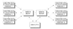
图1为本发明实施例导航系统示意图。在框图中主要包括了终端机、道路区域通信站和导航中心平台。Fig. 1 is a schematic diagram of a navigation system according to an embodiment of the present invention. The block diagram mainly includes a terminal, a road area communication station and a navigation center platform.
这里终端机主要负责基本信息的收集和发送,和机动车驾驶员进行交互,以及接收导航中心平台发送的路径信息。Here the terminal is mainly responsible for collecting and sending basic information, interacting with motor vehicle drivers, and receiving route information sent by the navigation center platform.
图2为本发明实施例终端机的结构示意图,其中包括了卫星接收模块、解算模块、用户输入模块、信息输出模块、通信模块,以及音视频模块等几部分。2 is a schematic structural diagram of a terminal according to an embodiment of the present invention, which includes a satellite receiving module, a calculation module, a user input module, an information output module, a communication module, and an audio and video module.
卫星接收模块能够接收卫星信号。这里的卫星信号可以是GPS系统卫星信号、北斗系统卫星信号、伽利略系统卫星信号,或者其他系统卫星信号,或者某几个系统的混合卫星信号。The satellite receiving module can receive satellite signals. The satellite signal here can be a GPS system satellite signal, a Beidou system satellite signal, a Galileo system satellite signal, or other system satellite signals, or a mixed satellite signal of several systems.
解算模块根据接收的卫星信号,能够解算得到当前车辆的位置信息。这里的位置信息可以是经纬度,也可以是结合地图得到的具体的城市地理位置。根据接收到的卫星信号,还能够解算得到车辆处于某个位置时的时间,以及处于某个位置的瞬时速度。The calculating module can calculate and obtain the current position information of the vehicle according to the received satellite signal. The location information here may be the latitude and longitude, or the specific geographical location of the city combined with the map. According to the received satellite signal, the time when the vehicle is at a certain position and the instantaneous speed at a certain position can also be calculated.
用户输入模块,提供了用户输入的途径,例如手写输入、键盘输入、或者语音输入,这里用户主要输入的信息包括目的地等。The user input module provides a way for the user to input, such as handwriting input, keyboard input, or voice input, where the main information input by the user includes destination and so on.
信息输出模块,提供了将信息展示给用户的途径,例如显示屏、语音等。这里展示给用户的信息主要包括路径,路况信息等。The information output module provides a way to display information to the user, such as display screen, voice, etc. The information displayed here to the user mainly includes route, road condition information and so on.
通信模块具有收发信息的通信功能,这里的通信功能可以采用现有的公共通信网络,比如GSM、GPRS、CDMA、WLAN等,也可以采用定制的通信网络。通信模块和道路区域通信站进行通信。The communication module has the communication function of sending and receiving information, and the communication function here can adopt an existing public communication network, such as GSM, GPRS, CDMA, WLAN, etc., or a customized communication network. The communication module communicates with the road area communication station.
音视频模块完成视频/图像显示和语音的输入功能。The audio and video module completes video/image display and voice input functions.
图3为本发明实施例导航中心平台的功能示意图,包括信息收发功能、最短时间路径计算、城市交通地图更新,和城市交通地图信息。Fig. 3 is a functional diagram of the navigation center platform according to the embodiment of the present invention, including information sending and receiving functions, shortest time path calculation, urban traffic map update, and urban traffic map information.
导航中心平台拥有城市交通地图,能够接收和发送经道路区域通信站转发的终端机消息,具有地图更新和导航计算能力,具有对路况进行预测的能力。在维护城市交通地图时,根据接收到的终端机信息,以预定周期更新维护所述城市交通地图信息。以预定周期更新维护所述城市交通地图信息包括:当前的路段车辆数目、平均车速,以及未来N分钟内的路段车辆数目、平均车速。具体而言,导航中心平台计算线路信息后经过道路区域通信站提供给终端收发机包括:能够根据所述城市交通地图信息和驾驶员的目的地信息,计算确定最短时间路径信息,将最短时间路径信息提供给终端收发机。The navigation center platform has urban traffic maps, can receive and send terminal messages forwarded by road area communication stations, has map update and navigation computing capabilities, and has the ability to predict road conditions. When maintaining the urban traffic map, the information of the urban traffic map is updated and maintained at a predetermined period according to the received terminal information. Updating and maintaining the urban traffic map information at a predetermined period includes: the current number of vehicles on the road section, the average vehicle speed, and the number of vehicles on the road section and the average vehicle speed in the next N minutes. Specifically, after the navigation center platform calculates the route information and provides it to the terminal transceiver through the road area communication station, it includes: being able to calculate and determine the shortest time route information according to the city traffic map information and the driver's destination information, and the shortest time route The information is provided to the terminal transceiver.
例如,导航中心平台获取包括当前的路段车辆数目,平均车速;还包括未来一段时间后的信息,例如:还包括未来N1分钟内的路段车辆数目,平均车速;未来N2分钟内的路段车辆数目,平均车速;未来N3分钟内的路段车辆数目,平均车速;未来N4分钟内的路段车辆数目,平均车速;未来N5分钟内的路段车辆数目,平均车速。这里,N1、N2、N3、N4和N5的取值一般为3、5、10、15和30。即,城市交通地图信息包含了当前和未来一段时间后的路况信息,包括车辆数目和平均速度。可以用图4所示表格来存储城市交通地图信息,或者以其他方式进行存储。For example, the navigation center platform obtains the number of vehicles on the current road section and the average speed; it also includes information after a period of time in the future, for example: the number of vehicles on the road section in the next N1 minutes, the average speed; the number of vehicles on the road section in the next N2 minutes, Average vehicle speed; the number of vehicles on the road section in the next N3 minutes, the average vehicle speed; the number of vehicles on the road section in the next N4 minutes, the average vehicle speed; the number of vehicles on the road section in the next N5 minutes, and the average vehicle speed. Here, the values of N1, N2, N3, N4 and N5 are generally 3, 5, 10, 15 and 30. That is, the urban traffic map information includes current and future road condition information, including the number of vehicles and average speed. The city traffic map information can be stored in the table shown in FIG. 4 , or stored in other ways.
在图3的模块中,信息收发功能完成和道路区域通信站进行通信的功能。城市交通地图更新根据终端机发送的信息和路径计算结果对市交通地图信息进行更新。最短时间路径计算根据机动车驾驶员提交的目的地和城市交通地图信息进行计算,得到最短时间路径。In the module in Fig. 3, the information sending and receiving function completes the function of communicating with the road area communication station. The city traffic map update updates the city traffic map information according to the information sent by the terminal and the path calculation results. The shortest time path calculation is calculated according to the destination and urban traffic map information submitted by the motor vehicle driver, and the shortest time path is obtained.
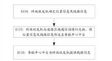
本发明另一方面还提出了一种导航方法,流程图如图5所示,包括以下步骤:On the other hand, the present invention also proposes a navigation method, the flow chart of which is shown in Figure 5, comprising the following steps:
S110:终端收发机确定位置信息及线路信息。S110: The terminal transceiver determines location information and line information.
在步骤S110中,安装在车辆上的终端收发机接收卫星信号,确定所述终端收发机的位置信息及线路信息。In step S110, the terminal transceiver installed on the vehicle receives satellite signals, and determines the location information and route information of the terminal transceiver.
卫星信号包括但不限于GPS系统卫星信号、北斗系统卫星信号、伽利略系统卫星信号。Satellite signals include, but are not limited to, GPS system satellite signals, Beidou system satellite signals, and Galileo system satellite signals.
具体而言,终端收发机具有卫星定位功能包括但不限于:Specifically, the terminal transceiver has satellite positioning functions including but not limited to:
根据接收的卫星信号,所述终端收发机计算得到车辆当前的位置信息,以及计算得到车辆处于所在位置时的瞬时速度和处于所在位置的时间信息。According to the received satellite signal, the terminal transceiver calculates the current position information of the vehicle, and calculates the instantaneous speed and time information of the vehicle at the position.
此外,终端收发机具有人机交互功能,驾驶员通过手写或语音进行信息输入;所述终端收发机通过屏幕显示或语音对外输出。In addition, the terminal transceiver has a human-computer interaction function, and the driver can input information through handwriting or voice; the terminal transceiver can output externally through screen display or voice.
终端收发机以预定周期或者在调整行驶方向时,将所述位置信息及线路信息与道路区域通信站进行交换。The terminal transceiver exchanges the position information and route information with the road area communication station at a predetermined period or when adjusting the driving direction.
S120:终端收发机与道路区域通信站进行交换,将位置信息及线路信息传送至导航中心平台。S120: The terminal transceiver exchanges with the road area communication station, and transmits the location information and route information to the navigation center platform.
在步骤S120中,终端收发机将所述位置信息及线路信息与道路区域通信站进行交换,经道路区域通信站将位置信息及线路信息传送至导航中心平台。In step S120, the terminal transceiver exchanges the location information and route information with the road area communication station, and transmits the location information and route information to the navigation center platform through the road area communication station.
终端收发机通过公共通信网络或特定通信网络与道路区域通信站进行通信,所述公共通信网络包括但不限于GSM、GPRS、CDMA、WLAN通信网络;道路区域通信站包括但不限于基站、WLAN热点或者定制通信节点。The terminal transceiver communicates with the road area communication station through the public communication network or a specific communication network, the public communication network includes but not limited to GSM, GPRS, CDMA, WLAN communication network; the road area communication station includes but not limited to base station, WLAN hotspot Or customize the communication node.
S130:导航中心平台为终端收发机提供线路信息。S130: The navigation center platform provides line information for the terminal transceiver.
在步骤S130中,导航中心平台根据终端收发机提供的信息,计算线路信息后经道路区域通信站提供给终端收发机。In step S130, the navigation center platform calculates the route information according to the information provided by the terminal transceiver and provides it to the terminal transceiver via the road area communication station.
导航中心平台根据所述城市交通地图信息以及所述终端收发机的位置信息和线路信息,以预定周期更新维护所述城市交通地图信息。The navigation center platform updates and maintains the urban traffic map information in a predetermined period according to the urban traffic map information and the location information and route information of the terminal transceiver.
以预定周期更新维护所述城市交通地图信息包括:Updating and maintaining the urban traffic map information with a predetermined period includes:
当前的路段车辆数目、平均车速,以及未来N分钟内的路段车辆数目、平均车速。The number of vehicles on the current road section, the average speed, and the number of vehicles on the road section and the average speed in the next N minutes.
导航中心平台计算线路信息后经过所述道路区域通信站提供给所述终端收发机包括:After the navigation center platform calculates the line information and provides it to the terminal transceiver through the road area communication station, it includes:
能够根据所述城市交通地图信息和驾驶员的目的地信息,计算确定最短时间路径信息,将所述最短时间路径信息提供给所述终端收发机。The shortest time route information can be calculated and determined according to the city traffic map information and the driver's destination information, and the shortest time route information can be provided to the terminal transceiver.
图6为本发明实施例导航方法功能框图。主要包括城市交通地图更新和最短时间路径导航方法。Fig. 6 is a functional block diagram of a navigation method according to an embodiment of the present invention. It mainly includes urban traffic map update and shortest time path navigation method.
在获取终端机的发送信息后,首先对当前的城市交通地图进行更新;并根据机动车驾驶员的目的地信息,进行最短时间路径计算,并在计算后更新未来一段时间后的城市交通地图。After obtaining the sending information of the terminal, first update the current urban traffic map; and calculate the shortest time path according to the destination information of the motor vehicle driver, and update the urban traffic map after a certain period of time after the calculation.
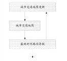
图7为本发明实施例城市交通地图更新方法流程图。首先,终端机将车辆的位置信息、时间、车速,发送给道路区域通信站。这里车辆发送信息的时机可以是定时发送,也可以是在调整行驶方向时发送。然后,道路区域通信站将信息转发给导航中心平台。然后,导航中心平台对接收到的每个终端机的信息进行处理。处理内容包括:统计位于同一路段的终端机数目,作为当前的路段车辆数目;计算位于同一路段的所有车辆平均速度,作为当前的路段平均车速。最后,在终端机提交目的地,并计算得到最短时间路径后,根据最短时间路径更新未来一段时间后的城市交通地图信息。Fig. 7 is a flowchart of a method for updating an urban traffic map according to an embodiment of the present invention. First, the terminal sends the vehicle's location information, time, and vehicle speed to the road area communication station. Here, the timing for the vehicle to send the information may be sent at regular intervals, or when the driving direction is adjusted. Then, the road area communication station forwards the information to the navigation center platform. Then, the navigation center platform processes the received information of each terminal. The processing content includes: counting the number of terminals located on the same road section as the current number of vehicles on the road section; calculating the average speed of all vehicles located on the same road section as the current average vehicle speed on the road section. Finally, after the terminal submits the destination and calculates the shortest time path, update the urban traffic map information for a period of time in the future according to the shortest time path.
图8为本发明实施例城市导航流程图。首先,机动车驾驶员将目的地输入到终端机,终端机发送包含目的地的消息到道路区域通信站。然后,道路区域通信站将信息转发给导航中心平台。然后,导航中心平台根据当前城市交通地图信息和未来一段时间后的城市交通地图信息进行计算,得到最短时间路径。然后,导航中心平台发送包含最短时间路径的消息到道路区域通信站。然后,道路区域通信站将信息转发给终端机。最后,终端机通过屏幕显示,或者语音的方式将路径信息通知给机动车驾驶员。Fig. 8 is a flow chart of city navigation according to an embodiment of the present invention. First, a driver of a motor vehicle inputs a destination into a terminal, and the terminal sends a message including the destination to a road area communication station. Then, the road area communication station forwards the information to the navigation center platform. Then, the navigation center platform calculates according to the current urban traffic map information and the urban traffic map information after a period of time in the future to obtain the shortest time route. Then, the navigation center platform sends a message containing the shortest time path to the road area communication station. Then, the road area communication station forwards the information to the terminal. Finally, the terminal notifies the motor vehicle driver of the route information through screen display or voice.
本发明提出的上述方案,考虑到每一个机动车驾驶员的出行需求,通过导航中心平台为其设计出线路信息,保证了机动车驾驶员快捷的到达目的地,也能够最大程度的保证道路通畅。另外,本发明提出的终端机可以安装在每一辆机动车上,克服了摄像头不能移动的特点,能够获取更完整的城市交通状况。同时,本发明提出的终端机能够发送包括时间、速度在内的信息,因此,导航中心平台可以获知道路的平均时速,可以更为准确的进行导航。The above solution proposed by the present invention takes into account the travel needs of each motor vehicle driver, and designs route information for it through the navigation center platform, which ensures that the motor vehicle driver can reach the destination quickly and can also ensure the smoothest roads to the greatest extent. . In addition, the terminal machine proposed by the present invention can be installed on every motor vehicle, overcomes the feature that the camera cannot be moved, and can obtain a more complete urban traffic situation. At the same time, the terminal proposed by the present invention can send information including time and speed. Therefore, the navigation center platform can obtain the average speed per hour of the road, and can navigate more accurately.
本技术领域的普通技术人员可以理解实现上述实施例方法携带的全部或部分步骤是可以通过程序来指令相关的硬件完成,所述的程序可以存储于一种计算机可读存储介质中,该程序在执行时,包括方法实施例的步骤之一或其组合。Those of ordinary skill in the art can understand that all or part of the steps carried by the methods of the above embodiments can be completed by instructing related hardware through a program, and the program can be stored in a computer-readable storage medium. During execution, one or a combination of the steps of the method embodiments is included.
此外,在本发明各个实施例中的各功能单元可以集成在一个处理模块中,也可以是各个单元单独物理存在,也可以两个或两个以上单元集成在一个模块中。上述集成的模块既可以采用硬件的形式实现,也可以采用软件功能模块的形式实现。所述集成的模块如果以软件功能模块的形式实现并作为独立的产品销售或使用时,也可以存储在一个计算机可读取存储介质中。In addition, each functional unit in each embodiment of the present invention may be integrated into one processing module, each unit may exist separately physically, or two or more units may be integrated into one module. The above-mentioned integrated modules can be implemented in the form of hardware or in the form of software function modules. If the integrated modules are realized in the form of software function modules and sold or used as independent products, they can also be stored in a computer-readable storage medium.
上述提到的存储介质可以是只读存储器,磁盘或光盘等。The storage medium mentioned above may be a read-only memory, a magnetic disk or an optical disk, and the like.
以上所述仅是本发明的部分实施方式,应当指出,对于本技术领域的普通技术人员来说,在不脱离本发明原理的前提下,还可以做出若干改进和润饰,这些改进和润饰也应视为本发明的保护范围。The above descriptions are only part of the embodiments of the present invention. It should be pointed out that those skilled in the art can make some improvements and modifications without departing from the principles of the present invention. It should be regarded as the protection scope of the present invention.
Claims (18)
Priority Applications (1)
| Application Number | Priority Date | Filing Date | Title |
|---|---|---|---|
| CN2011101066712ACN102759738A (en) | 2011-04-27 | 2011-04-27 | Navigation system and method thereof |
Applications Claiming Priority (1)
| Application Number | Priority Date | Filing Date | Title |
|---|---|---|---|
| CN2011101066712ACN102759738A (en) | 2011-04-27 | 2011-04-27 | Navigation system and method thereof |
Publications (1)
| Publication Number | Publication Date |
|---|---|
| CN102759738Atrue CN102759738A (en) | 2012-10-31 |
Family
ID=47054248
Family Applications (1)
| Application Number | Title | Priority Date | Filing Date |
|---|---|---|---|
| CN2011101066712APendingCN102759738A (en) | 2011-04-27 | 2011-04-27 | Navigation system and method thereof |
Country Status (1)
| Country | Link |
|---|---|
| CN (1) | CN102759738A (en) |
Cited By (1)
| Publication number | Priority date | Publication date | Assignee | Title |
|---|---|---|---|---|
| CN102946430A (en)* | 2012-11-13 | 2013-02-27 | 中国电子科技集团公司第十五研究所 | Commanding and dispatching system and method |
Citations (8)
| Publication number | Priority date | Publication date | Assignee | Title |
|---|---|---|---|---|
| CN1317422A (en)* | 2001-04-28 | 2001-10-17 | 陈新愚 | Method and equipment for vehicle pilot and road network management |
| CN1409280A (en)* | 2002-08-14 | 2003-04-09 | 冯鲁民 | Municipal intelligent traffic and vehicle navigation system |
| JP2007218924A (en)* | 2007-03-28 | 2007-08-30 | Xanavi Informatics Corp | Method for searching route in navigation apparatus |
| CN101178851A (en)* | 2007-11-27 | 2008-05-14 | 张涛 | Intelligent traffic control system and method based on vehicle mounted intelligent terminal |
| CN101339042A (en)* | 2008-08-11 | 2009-01-07 | 肖禄生 | Personalized dynamic road condition information creation and navigation system |
| CN101482419A (en)* | 2008-01-11 | 2009-07-15 | 上海邮电设计院有限公司 | Vehicle dynamic navigation service system based on A-GPS and 3G network |
| US20090182497A1 (en)* | 2006-12-01 | 2009-07-16 | Denso Corporation | Navigation system, in-vehicle navigation apparatus and center apparatus |
| CN101799979A (en)* | 2010-03-18 | 2010-08-11 | 张兴莲 | All-weather driving service system |
- 2011
- 2011-04-27CNCN2011101066712Apatent/CN102759738A/enactivePending
Patent Citations (8)
| Publication number | Priority date | Publication date | Assignee | Title |
|---|---|---|---|---|
| CN1317422A (en)* | 2001-04-28 | 2001-10-17 | 陈新愚 | Method and equipment for vehicle pilot and road network management |
| CN1409280A (en)* | 2002-08-14 | 2003-04-09 | 冯鲁民 | Municipal intelligent traffic and vehicle navigation system |
| US20090182497A1 (en)* | 2006-12-01 | 2009-07-16 | Denso Corporation | Navigation system, in-vehicle navigation apparatus and center apparatus |
| JP2007218924A (en)* | 2007-03-28 | 2007-08-30 | Xanavi Informatics Corp | Method for searching route in navigation apparatus |
| CN101178851A (en)* | 2007-11-27 | 2008-05-14 | 张涛 | Intelligent traffic control system and method based on vehicle mounted intelligent terminal |
| CN101482419A (en)* | 2008-01-11 | 2009-07-15 | 上海邮电设计院有限公司 | Vehicle dynamic navigation service system based on A-GPS and 3G network |
| CN101339042A (en)* | 2008-08-11 | 2009-01-07 | 肖禄生 | Personalized dynamic road condition information creation and navigation system |
| CN101799979A (en)* | 2010-03-18 | 2010-08-11 | 张兴莲 | All-weather driving service system |
Cited By (2)
| Publication number | Priority date | Publication date | Assignee | Title |
|---|---|---|---|---|
| CN102946430A (en)* | 2012-11-13 | 2013-02-27 | 中国电子科技集团公司第十五研究所 | Commanding and dispatching system and method |
| CN102946430B (en)* | 2012-11-13 | 2015-09-09 | 中国电子科技集团公司第十五研究所 | Command dispatching system and method |
Similar Documents
| Publication | Publication Date | Title |
|---|---|---|
| TWI676970B (en) | Traffic lane selecting method, target vehicles, and computer storage medium | |
| CN103442072B (en) | The transport information method for pushing related to subscriber calendar and device | |
| CN105679061B (en) | traffic control system | |
| US9683850B2 (en) | Method for navigation using adaptive coverage | |
| CN105051493B (en) | Method and device for transmission route | |
| CN111044056A (en) | Location method, chip subsystem and electronic device based on road matching | |
| US20150345968A1 (en) | Navigation Method and System, Map Data Management Cloud and Data Update Method Thereof | |
| CN103116995B (en) | Car networking data transmission route selection optimized method based on electronic eyes | |
| CN105489043B (en) | Real-time route planing method based on vehicular ad hoc network | |
| CN111798039B (en) | Student pick-up auxiliary system | |
| CN105139680A (en) | Dynamic navigation method based on traffic large data driving and system | |
| CN104537852A (en) | Road accident prompting method based on vehicle-road collaboration | |
| CN107564310A (en) | A kind of bus or train route interacted system and method based on the processing of Traffic Information cloud | |
| US9008964B2 (en) | Device for road and urban mobility and for solving the problem of traffic congestion | |
| CN105894842A (en) | Intelligent traffic signal lamp system | |
| CN103544838A (en) | Vehicular multi-hop cooperative transmission based road condition information acquisition method | |
| CN101619981A (en) | Self-service tour guide and navigation terminal and method for optimally selecting tour guide and navigation information | |
| CN103136950A (en) | Method of providing comprehensive road condition information | |
| CN104089622A (en) | Navigation method based on mobile terminals | |
| US20200401959A1 (en) | Emergency traffic management system using mobile device | |
| CN104599528A (en) | Beidou based intelligent vehicle monitoring method | |
| CN109421697A (en) | A kind of control method for vehicle, device and system | |
| CN101093168B (en) | Navigation system, and navigation method | |
| KR102228388B1 (en) | Vehicle control apparatus and method for sharing location information | |
| CN104991226A (en) | Positioning navigation equipment based on ZigBee street lamp control system and applications thereof |
Legal Events
| Date | Code | Title | Description |
|---|---|---|---|
| C06 | Publication | ||
| PB01 | Publication | ||
| C10 | Entry into substantive examination | ||
| SE01 | Entry into force of request for substantive examination | ||
| C12 | Rejection of a patent application after its publication | ||
| RJ01 | Rejection of invention patent application after publication | Application publication date:20121031 |