CN102750419A - Subway comprehensive pipeline aided design system and method - Google Patents
Subway comprehensive pipeline aided design system and methodDownload PDFInfo
- Publication number
- CN102750419A CN102750419ACN2012102157145ACN201210215714ACN102750419ACN 102750419 ACN102750419 ACN 102750419ACN 2012102157145 ACN2012102157145 ACN 2012102157145ACN 201210215714 ACN201210215714 ACN 201210215714ACN 102750419 ACN102750419 ACN 102750419A
- Authority
- CN
- China
- Prior art keywords
- pipeline
- scene
- information
- model
- data
- Prior art date
- Legal status (The legal status is an assumption and is not a legal conclusion. Google has not performed a legal analysis and makes no representation as to the accuracy of the status listed.)
- Granted
Links
Images


Landscapes
- Processing Or Creating Images (AREA)
Abstract
Description
Translated fromChinese技术领域technical field
本发明属于计算机相关应用领域,具体涉及一种地铁综合管线辅助设计系统,还涉及这种辅助设计系统的设计方法。The invention belongs to the related application field of computers, and in particular relates to an auxiliary design system for comprehensive pipelines of subways, and also relates to a design method of the auxiliary design system.
背景技术Background technique
近年来,随着我国国民经济的发展和人民生活水平的不断提高,大中城市的交通状况日渐紧张,道路交通条件不断恶化。人们逐步认识到只有发展以地下铁道为骨干的大运量快速公共交通系统才能解决城市客运交通紧张问题。而综合管线的设计在地铁车站的设计及施工过程中尤为重要。综合管线在整个设计与施工过程中对各专业管线的设计及施工起指导作用。综合管线设计得是否合理直接影响到车站各层的层高、建筑装修、车站设备的安全以及各管线能否顺利安装。In recent years, with the development of my country's national economy and the continuous improvement of people's living standards, the traffic conditions in large and medium-sized cities have become increasingly tense, and road traffic conditions have continued to deteriorate. People have gradually realized that only by developing a large-capacity rapid public transport system with underground railways as the backbone can the problem of urban passenger traffic tension be solved. The design of integrated pipelines is particularly important in the design and construction of subway stations. The comprehensive pipeline plays a guiding role in the design and construction of various professional pipelines throughout the design and construction process. Whether the comprehensive pipeline design is reasonable or not directly affects the height of each floor of the station, building decoration, the safety of station equipment and whether the pipelines can be installed smoothly.
综合管线专业的特点和作用有以下几点:The characteristics and functions of the comprehensive pipeline specialty are as follows:
1.综合管线图是各个专业管线和设备布置设计的综合汇总及各专业之间设计协调平衡工作的体现。合理的设计可以使得地下空间充分、合理、有效的使用,更有利于管线的施工安装和运营管理维修,亦可减少管线安装过程中的返工现象。同时综合管线又是车站建筑装修设计的基础资料;1. The comprehensive pipeline diagram is a comprehensive summary of the layout design of various professional pipelines and equipment and a reflection of the coordination and balance of design among various disciplines. Reasonable design can make the underground space fully, rationally and effectively used, which is more conducive to the construction, installation, operation, management and maintenance of pipelines, and can also reduce rework during pipeline installation. At the same time, the comprehensive pipeline is the basic data for the design of station building decoration;
2.综合管线是一个综合性并具有指导性的设计文件。其综合性是指其是各个专业管线的综合,其指导性是指各个专业的管线设计及施工必须符合综合管线图设计的整体安排;2. The integrated pipeline is a comprehensive and instructive design document. Its comprehensiveness means that it is a synthesis of various professional pipelines, and its guidance means that the design and construction of each professional pipeline must conform to the overall arrangement of the comprehensive pipeline diagram design;
3.综合管线施工图的设计过程是不断协调各专业管线设计的过程。当各专业管线设计发现综合管线给定空间不够时又要反过来进行协调,最终共同完成管线图的设计;3. The design process of comprehensive pipeline construction drawings is a process of continuously coordinating the design of various professional pipelines. When the professional pipeline design finds that the given space of the comprehensive pipeline is not enough, they need to coordinate in reverse, and finally jointly complete the design of the pipeline diagram;
4.综合管线图是各专业管线的综合汇总,但又不是各专业管线的简单叠加。其综合性有以下两点:一是各专业空间使用的平衡与协调的工作;二是各专业管线的简化。其简化的原则是为了使各专业设计人员及施工人员能读懂图纸,起到其真正的综合指导作用。4. The comprehensive pipeline diagram is a comprehensive summary of various professional pipelines, but it is not a simple superposition of various professional pipelines. Its comprehensiveness has the following two points: one is the balance and coordination of the use of various professional spaces; the other is the simplification of various professional pipelines. The principle of simplification is to enable the professional designers and construction personnel to understand the drawings and play a truly comprehensive guiding role.
但目前综合管线图纸设计人员使用的设计图纸的工具是AutoDesk公司制作的软件AutoCAD,其在管线绘图过程中只能直观的显示二维坐标内的信息,如:X坐标,Y坐标,并且标注混乱、线条错综复杂。而管线在现实世界中是存在空间三维数据的,即X坐标,Y坐标,Z坐标。在AutoCAD图中,管线的第三维信息就只能用标注的形式表现出来,即目前通常用到的标高(标高表示管线距特定地面的高度)。但这种标注不够直观明了,且有时标注过多,造成混乱,亦有时标注过少,很不清晰,这样会给读图带来严重的负面影响。由于设计人员的水平、经验以及仔细程度的差异,设计出来的图纸中肯定存在管线“打架”现象,但这种现象在AutoCAD图纸中又不能直观的反映出来,因此,给施工及后期的检修等造成很多困难。However, the tool used by designers of comprehensive pipeline drawings to design drawings is the software AutoCAD produced by AutoDesk, which can only intuitively display information in two-dimensional coordinates during the pipeline drawing process, such as: X coordinates, Y coordinates, and the labels are confusing , The lines are intricate. In the real world, pipelines have spatial three-dimensional data, that is, X coordinates, Y coordinates, and Z coordinates. In the AutoCAD drawing, the third-dimensional information of the pipeline can only be expressed in the form of labels, that is, the elevation commonly used at present (the elevation indicates the height of the pipeline from a specific ground). However, this kind of labeling is not intuitive and clear enough, and sometimes there are too many labels, causing confusion, and sometimes too few labels, which are very unclear, which will have a serious negative impact on reading pictures. Due to the differences in the level, experience and carefulness of the designers, there must be "fighting" phenomena in the designed drawings, but this phenomenon cannot be reflected intuitively in the AutoCAD drawings. Therefore, for construction and later maintenance, etc. cause many difficulties.
发明内容Contents of the invention
本发明的目的是提供一种地铁综合管线辅助设计系统,直观的模拟管线的空间位置,实现地铁场景及管线的三维可视化,解决现有地铁综合管线之间的“打架”现象。The purpose of the present invention is to provide an auxiliary design system for comprehensive subway pipelines, which can intuitively simulate the spatial position of pipelines, realize three-dimensional visualization of subway scenes and pipelines, and solve the "fighting" phenomenon between existing subway comprehensive pipelines.
本发明的另一个目的在于提供上述地铁综合管线辅助设计系统的设计方法。Another object of the present invention is to provide a design method for the above-mentioned aided design system for comprehensive pipelines of subways.
本发明的目的是这样实现的,一种地铁综合管线辅助设计系统,包括管线碰撞检测模块、场景漫游模块及管线编辑模块。The object of the present invention is achieved in the following way. A subway integrated pipeline auxiliary design system includes a pipeline collision detection module, a scene roaming module and a pipeline editing module.
所述管线碰撞检测模块主要检测不同类型的管线之间是否发生碰撞,如果碰撞则会发出碰撞警告并反馈碰撞信息;The pipeline collision detection module mainly detects whether there is a collision between different types of pipelines, and if there is a collision, a collision warning will be issued and collision information will be fed back;
所述场景漫游模块包括场景及管线模型管理、管线的空间定位及场景的三维漫游;The scene roaming module includes scene and pipeline model management, spatial positioning of pipelines and three-dimensional roaming of scenes;
所述管线编辑模块实现对管线属性信息和空间位置信息的修改、查看、删除、增添操作,并可以直接对管线模型进行空间位置移动。The pipeline editing module implements operations of modifying, viewing, deleting and adding pipeline attribute information and spatial position information, and can directly move the spatial position of the pipeline model.
所述场景及管线模型管理的主要功能就是方便用户俯瞰整个场景,对整个场景及管线布局实现整体预览,该功能将场景中的模型按照树形结构显示出来,并形象化展示场景模型、管线模型和地铁站整个模型的层次结构关系,同时每个场景模型块和每类管线模型都能根据用户的选择进行显示和隐藏;The main function of the scene and pipeline model management is to facilitate the user to overlook the entire scene and realize the overall preview of the entire scene and pipeline layout. This function displays the models in the scene according to the tree structure, and visualizes the scene model and pipeline model. The hierarchical relationship with the entire model of the subway station, while each scene model block and each type of pipeline model can be displayed and hidden according to the user's choice;
所述管线的空间定位功能可实现管线从平面信息到三模型的视觉转换,方便用户快速找到所要查找管线的空间位置;The spatial positioning function of the pipeline can realize the visual conversion of the pipeline from the plane information to the three-model, which is convenient for the user to quickly find the spatial position of the pipeline to be searched;
所述场景的三维漫游功能可以使综合管线设计人员摆脱场景的三维想象,可以模拟现实地漫游地铁站场景,直观了解管线与地铁站房建结构以及管线之间的位置关系;用户可以通过键盘按键进行场景镜头的前后左右移动,或者只用鼠标对场景镜头进行移动,来达到漫游场景的目的。The three-dimensional roaming function of the scene can make the comprehensive pipeline designer get rid of the three-dimensional imagination of the scene, and can simulate the realistic roaming of the subway station scene, and intuitively understand the positional relationship between the pipeline, the building structure of the subway station and the pipeline; the user can use the keyboard key Move the scene camera back and forth, left and right, or just use the mouse to move the scene camera to achieve the purpose of roaming the scene.
本发明的另一个目的是这样实现的,所述地铁综合管线辅助设计系统的设计方法,包括提取数据和建模,所述提取数据为将AutoCAD图纸坐标系原点统一,并对应到三维场景模型中,数据包括管线的起点和终点坐标、管线的标高及在图纸中的颜色,将提取出来的管线信息录入到临时文件表格中,批量导入到数据库中;所述建模包括三维场景建模和数据库建模。Another object of the present invention is achieved in this way, the design method of the subway comprehensive pipeline auxiliary design system includes extracting data and modeling, and the extracting data is to unify the origin of the AutoCAD drawing coordinate system and correspond to the three-dimensional scene model , the data includes the coordinates of the starting point and end point of the pipeline, the elevation of the pipeline and the color in the drawing, and the extracted pipeline information is entered into a temporary file form and imported into the database in batches; the modeling includes 3D scene modeling and database modeling.
所述三维场景建模为把管线的属性信息(如管线类型、管线名称、管线用途、生产厂商等)存储到SQL SERVER数据库中,把三维渲染需要的空间信息(如坐标及颜色信息等)存储到类似配置文件的XML文件中;采用C/S结构,运用两层架构,即管线信息表示层(UI)与管线业务逻辑层(BLL)结合的综合层和管线数据访问层(DAL);管线信息表示层(UI)与管线业务逻辑层(BLL)通过管线数据访问层(DAL)与SQL SERVER数据库和XML文件进行数据交互,管线数据访问层主要通过管线属性信息类访问SQLSERVER数据库、通过管线空间信息类访问XML文件。The 3D scene modeling is to store the attribute information of the pipeline (such as pipeline type, pipeline name, pipeline use, manufacturer, etc.) in the SQL SERVER database, and store the spatial information (such as coordinates and color information, etc.) into an XML file similar to a configuration file; adopt a C/S structure, and use a two-layer architecture, that is, an integrated layer and a pipeline data access layer (DAL) combining the pipeline information presentation layer (UI) and the pipeline business logic layer (BLL); the pipeline The information presentation layer (UI) and the pipeline business logic layer (BLL) perform data interaction with the SQL Server database and XML files through the pipeline data access layer (DAL). The information class accesses the XML file.
管线信息表现层(UI)负责显示三维场景、综合管线模型、管线信息以及各个功能模块的前台界面等,响应用户请求(如管线的查看、定位或者移动等)并交予业务逻辑层处理,为用户提供一种基于三维展示的交互式操作界面;管线业务逻辑层(BLL)负责处理用户输入的信息,或者将这些信息发送给数据访问层进行保存,或者是调用数据访问层再次读出这些信息,同时实现对数据的增、删、改、查操作,提供整个平台的业务逻辑的支持。The pipeline information presentation layer (UI) is responsible for displaying 3D scenes, comprehensive pipeline models, pipeline information, and the front-end interface of each functional module, responding to user requests (such as pipeline viewing, positioning, or moving, etc.) and handing over to the business logic layer for processing. The user provides an interactive operation interface based on three-dimensional display; the pipeline business logic layer (BLL) is responsible for processing the information input by the user, or sending the information to the data access layer for storage, or calling the data access layer to read out the information again , at the same time realize the operation of adding, deleting, modifying and checking the data, and provide the support of the business logic of the whole platform.
本发明有如下有益效果:The present invention has following beneficial effect:
1.本发明实现了三维可视化。与传统的AutoCAD图纸相比,本发明可以更直观的展示综合管线布局。1. The present invention realizes three-dimensional visualization. Compared with traditional AutoCAD drawings, the present invention can display the comprehensive pipeline layout more intuitively.
2.本发明简单易操作。本发明在调整管线布局这一块实现用鼠标拖拽的简单操作,省去了繁冗的操作过程。2. The present invention is simple and easy to operate. The present invention realizes the simple operation of dragging and dropping with the mouse in the part of adjusting the pipeline layout, which saves the cumbersome operation process.
3.本发明实现了智能化报警。只要在AutoCAD图纸中出现管线碰撞现象,由此数据生成的管线数据模型在本发明中都能出现碰撞报警提示。3. The present invention realizes intelligent alarm. As long as there is a pipeline collision phenomenon in the AutoCAD drawing, the pipeline data model generated from this data can have a collision alarm prompt in the present invention.
4.本发明系统中的管线模型都可以实现定位功能,省去了在错综复杂的图纸中的查找过程。4. All the pipeline models in the system of the present invention can realize the positioning function, which saves the search process in the intricate drawings.
5.本发明生动形象的展示车站的场景布局,实现了三维漫游场景。5. The present invention vividly displays the scene layout of the station, realizing a three-dimensional roaming scene.
附图说明Description of drawings
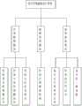
图1是本发明系统功能模块图;Fig. 1 is a functional block diagram of the system of the present invention;
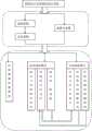
图2是本发明系统框架图;Fig. 2 is a system frame diagram of the present invention;
图3是本发明系统架构图;Fig. 3 is a system architecture diagram of the present invention;
图4是本发明管线查询流程图;Fig. 4 is a flow chart of the pipeline query of the present invention;
图5是本发明管线添加流程图;Fig. 5 is the pipeline adding flowchart of the present invention;
图6是本发明管线删除流程图;Fig. 6 is a flowchart of pipeline deletion in the present invention;
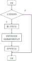
图7是本发明管线修改流程图;Fig. 7 is a flowchart of pipeline modification of the present invention;
图8是本发明管线空间定位流程图;Fig. 8 is a flow chart of pipeline space positioning in the present invention;
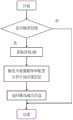
图9是本发明管线碰撞检测流程图;Fig. 9 is a flow chart of pipeline collision detection in the present invention;
图10是本发明管线空间移位流程图;Fig. 10 is a flow chart of pipeline space displacement in the present invention;
图11是本发明场景、管线模型管理流程图;Fig. 11 is a flowchart of scene and pipeline model management in the present invention;
图12是本发明管线空间移位示意图。Fig. 12 is a schematic diagram of the spatial displacement of the pipeline of the present invention.
具体实施方式Detailed ways
一种地铁综合管线辅助设计系统,包括管线碰撞检测模块、场景漫游模块及管线编辑模块。A comprehensive pipeline auxiliary design system for subways, including a pipeline collision detection module, a scene roaming module and a pipeline editing module.
管线碰撞检测模块主要检测不同类型的管线之间是否发生碰撞,如果碰撞则会发出碰撞警告并反馈碰撞信息;The pipeline collision detection module mainly detects whether there is a collision between different types of pipelines, and if there is a collision, a collision warning will be issued and the collision information will be fed back;
场景漫游模块包括场景及管线模型管理、管线的空间定位及场景的三维漫游;The scene roaming module includes scene and pipeline model management, spatial positioning of pipelines and three-dimensional roaming of scenes;
管线编辑模块实现对管线属性信息和空间位置信息的修改、查看、删除、增添操作,并可以直接对管线模型进行空间位置移动。The pipeline editing module realizes the modification, viewing, deletion and addition of pipeline attribute information and spatial position information, and can directly move the spatial position of the pipeline model.
场景及管线模型管理的主要功能就是方便用户俯瞰整个场景,对整个场景及管线布局实现整体预览。当模型和管线不完全加载时会节省很多计算机资源,从而提高了系统的运行效率。该功能将场景中的模型按照树形结构显示出来,并形象化展示场景模型、管线模型和地铁站整个模型的层次结构关系,同时每个场景模型块和每类管线模型都能根据用户的选择进行显示和隐藏。The main function of scene and pipeline model management is to facilitate users to overlook the entire scene and realize the overall preview of the entire scene and pipeline layout. It saves a lot of computer resources when the model and pipeline are not fully loaded, thus improving the operating efficiency of the system. This function displays the models in the scene in a tree structure, and visualizes the hierarchical relationship between the scene model, the pipeline model and the entire model of the subway station. At the same time, each scene model block and each type of pipeline model can be selected according to the user's choice. to show and hide.
管线的空间定位功能实现了管线从平面信息到三模型的视觉转换,查到管线的空间属性信息后可以直接跳转到该管线所在位置,将管线模型呈现在视觉窗口中间,并呈现选中状态。在管线信息查询功能的基础上,当用户查询到所要求的管线后,希望查看其空间位置,则双击此管线在信息列表中的位置,系统根据此管线的空间信息,迅速将三维场景转换到此管线处。空间定位功能方便用户快速找到所要查找管线的空间位置。The spatial positioning function of the pipeline realizes the visual transformation of the pipeline from the plane information to the three-model. After finding the spatial attribute information of the pipeline, it can directly jump to the location of the pipeline, and the pipeline model is presented in the middle of the visual window and is in the selected state. On the basis of the pipeline information query function, when the user queries the required pipeline and wants to view its spatial position, double-click the position of the pipeline in the information list, and the system quickly converts the 3D scene to at this pipeline. The spatial positioning function is convenient for users to quickly find the spatial position of the pipeline they are looking for.
场景的三维漫游功能可以使综合管线设计人员摆脱场景的三维想象,可以模拟现实地漫游地铁站场景,直观了解管线与地铁站房建结构以及管线之间的位置关系。用户可以通过键盘特定按键进行场景镜头的前后左右移动,或者只用鼠标对场景镜头进行移动,来达到漫游场景的目的。The 3D roaming function of the scene can free the comprehensive pipeline designer from the 3D imagination of the scene, and can simulate the realistic roaming of the subway station scene, and intuitively understand the positional relationship between the pipeline, the building structure of the subway station, and the pipeline. The user can move the scene lens forward, backward, left, and right through the specific keys of the keyboard, or only use the mouse to move the scene lens to achieve the purpose of roaming the scene.
本发明地铁综合管线辅助设计系统的设计方法,包括提取数据和建模,提取数据为将AutoCAD图纸坐标系原点统一,并对应到三维场景模型中,数据包括管线的起点和终点坐标、管线的标高及在图纸中的颜色,将提取出来的管线信息录入到临时文件表格中,批量导入到数据库中;所述建模包括三维场景建模和数据库建模。The design method of the subway integrated pipeline auxiliary design system of the present invention includes extracting data and modeling. The extracting data is to unify the origin of the AutoCAD drawing coordinate system and correspond to the three-dimensional scene model. The data includes the coordinates of the starting point and end point of the pipeline, and the elevation of the pipeline and the colors in the drawings, enter the extracted pipeline information into a temporary file table, and import them into the database in batches; the modeling includes 3D scene modeling and database modeling.
三维场景建模为把管线的属性信息(如管线类型、管线名称、管线用途、生产厂商等)存储到SQL SERVER数据库中,把三维渲染需要的空间信息(如坐标及颜色信息等)存储到类似配置文件的XML文件中;采用C/S结构,运用两层架构,即管线信息表示层(UI)与管线业务逻辑层(BLL)结合的综合层和管线数据访问层(DAL);管线信息表示层(UI)与管线业务逻辑层(BLL)通过管线数据访问层(DAL)与SQL SERVER数据库和XML文件进行数据交互,管线数据访问层主要通过管线属性信息类访问SQLSERVER数据库、通过管线空间信息类访问XML文件。3D scene modeling is to store pipeline attribute information (such as pipeline type, pipeline name, pipeline use, manufacturer, etc.) In the XML file of the configuration file; the C/S structure is adopted, and a two-layer architecture is used, namely, the integrated layer combined with the pipeline information presentation layer (UI) and the pipeline business logic layer (BLL) and the pipeline data access layer (DAL); the pipeline information representation Layer (UI) and pipeline business logic layer (BLL) perform data interaction with SQL SERVER database and XML files through the pipeline data access layer (DAL). Access the XML file.
管线信息表现层(UI)负责显示三维场景、综合管线模型、管线信息以及各个功能模块的前台界面等,响应用户请求(如管线的查看、定位或者移动等)并交予业务逻辑层处理,为用户提供一种基于三维展示的交互式操作界面;管线业务逻辑层(BLL)负责处理用户输入的信息,或者将这些信息发送给数据访问层进行保存,或者是调用数据访问层再次读出这些信息,同时实现对数据的增、删、改、查操作,它提供了整个平台的业务逻辑的支持。The pipeline information presentation layer (UI) is responsible for displaying 3D scenes, comprehensive pipeline models, pipeline information, and the front-end interface of each functional module, responding to user requests (such as pipeline viewing, positioning, or moving, etc.) and handing over to the business logic layer for processing. The user provides an interactive operation interface based on three-dimensional display; the pipeline business logic layer (BLL) is responsible for processing the information input by the user, or sending the information to the data access layer for storage, or calling the data access layer to read out the information again , while realizing the addition, deletion, modification, and query operations of data, it provides the support of the business logic of the entire platform.
本发明以传统的AutoCAD图为基础,结合三维可视化技术做出了功能加强。The invention is based on the traditional AutoCAD drawing, combined with three-dimensional visualization technology to make function enhancement.
本发明是一个面向地铁工程设计领域的专业辅助设计软件系统,其开发过程符合软件工程开发过程,本系统开发使用快速原型开发模式并不断与用户沟通结合新的需求添加功能。The present invention is a professional auxiliary design software system oriented to the field of subway engineering design. Its development process conforms to the software engineering development process. The development of the system uses a rapid prototype development mode and constantly communicates with users in combination with new requirements to add functions.
本发明为三维可视化系统。一般的三维模型使用3DS Max工具来完成,但3DS Max建立的模型不能数字化,即一旦建立就固定不能在系统中管理。而本发明的管理对象是管线及管线附属设备,这些模型在系统中应该是变量,这些模型的属性数据和空间数据必须存储到数据库中,以便管理。因此,本系统运用OpenGL技术在车站模型中渲染管线,且渲染用到的空间数据和属性数据来自数据库,可以实时管理。The present invention is a three-dimensional visualization system. The general 3D model is completed using 3DS Max tools, but the model created by 3DS Max cannot be digitized, that is, once established, it cannot be managed in the system. The management objects of the present invention are pipelines and pipeline accessories. These models should be variables in the system. The attribute data and spatial data of these models must be stored in the database for management. Therefore, this system uses OpenGL technology to render the pipeline in the station model, and the spatial data and attribute data used for rendering come from the database and can be managed in real time.
本发明为了避免地铁综合管线在最后的施工图中出现管线碰撞现象,从图纸中提取到的管线空间数据在进行三维实现时,系统会进行管线碰撞检测,如果出现管线间的碰撞现象,系统会提示设计人员做出管线位置的调整,同时设计人员也能在本系统内对管线空间移动和做出各种调整尝试,再根据调整结果对AutoCAD图纸做出调整。这样就会避免在AutoCAD图纸中出现管线碰撞现象,不仅有助于综合管线设计人员设计出更完美的图纸,也为施工人员施工带来方便,进而节省工期甚至资金投入。In order to avoid the pipeline collision phenomenon in the final construction drawing of the comprehensive subway pipeline in the present invention, when the pipeline space data extracted from the drawing is implemented in three dimensions, the system will perform pipeline collision detection. If there is a collision phenomenon between pipelines, the system will Prompt the designer to adjust the position of the pipeline. At the same time, the designer can also move the pipeline space and make various adjustment attempts in this system, and then adjust the AutoCAD drawing according to the adjustment result. This will avoid pipeline collisions in AutoCAD drawings, which will not only help comprehensive pipeline designers design more perfect drawings, but also bring convenience to construction personnel, thereby saving construction time and even capital investment.
下面结合附图和具体实施方式对本发明进行详细说明。The present invention will be described in detail below in conjunction with the accompanying drawings and specific embodiments.
一、本发明地铁综合管线辅助设计系统1. Auxiliary design system for integrated subway pipelines of the present invention
如图1所示,本发明主要包括三个模块,管线编辑模块、管线碰撞检测模块、场景漫游模块。其框架图如图2所示。这些功能模块是基于数据提取、场景建模、数据库建模完成的基础上开发的。其中管线碰撞检测模块是一个独立的模块,只要配置文件中有管线的空间位置信息,该模块就可以做出检测,并提交碰撞检测结果。场景漫游模块中的管线空间定位功能和场景的三维漫游功能是管线编辑模块中管线空间位置移动功能的基础。管线及管线类型的编辑功能是管线空间定位功能实现的前提条件。As shown in FIG. 1 , the present invention mainly includes three modules, a pipeline editing module, a pipeline collision detection module, and a scene roaming module. Its frame diagram is shown in Figure 2. These functional modules are developed on the basis of data extraction, scene modeling, and database modeling. The pipeline collision detection module is an independent module. As long as the configuration file contains the spatial location information of pipelines, this module can detect and submit the collision detection results. The pipeline space positioning function in the scene roaming module and the three-dimensional roaming function of the scene are the basis of the pipeline space position movement function in the pipeline editing module. The editing function of pipeline and pipeline type is the prerequisite for realizing the pipeline space positioning function.
1、提取数据1. Extract data
本发明将AutoCAD图中有用的信息提取出来,并形成本发明中能用的数据,这些数据包括:管线的起点和终点X,Y坐标以及管线标高;管线在图纸中的颜色。由于设计人员的个人习惯原因,AutoCAD制图不可能遵循同一个规范,因此目前的提取数据的方法没有实现智能化,几乎纯人工提取。方法就是将AutoCAD图纸坐标系原点统一,并对应到之前做好的三维场景中,这样提取出来的数据就是可用的,可以将管线的模型融合到场景中。The present invention extracts the useful information in the AutoCAD figure, and forms the data that can be used in the present invention, and these data include: starting point and end point X of pipeline, Y coordinate and pipeline elevation; The color of pipeline in drawing. Due to the personal habits of designers, it is impossible for AutoCAD drawings to follow the same specification, so the current method of extracting data is not intelligent, and it is almost purely manual extraction. The method is to unify the origin of the AutoCAD drawing coordinate system and map it to the previously prepared 3D scene, so that the extracted data is available and the pipeline model can be integrated into the scene.
将提取出来的管线信息按照特定格式录入到临时文件表格中,用本系统批量导入到数据库中,也可以用本系统进行单条管线的信息录入。Enter the extracted pipeline information into a temporary file form according to a specific format, and use this system to import it into the database in batches, or use this system to input information for a single pipeline.
2、三维场景建模2. 3D scene modeling
本发明不是完全摒弃现有技术,所以系统的数据来源仍然是综合管线专业AutoCAD图纸。The present invention does not completely abandon the prior art, so the data source of the system is still the professional AutoCAD drawing of the comprehensive pipeline.
车站三维场景的制作主要参照设计人员绘制的AutoCAD图纸的房建图部分,必须包含车站的水平剖面图和纵剖面图。在保证场景数据量较小的前提下,为了达到与现实结构相符,可以做一定的美化工作。该场景为固有数据,针对特定的地铁站,所以每个不同的站都需重新三维建模。The production of the 3D scene of the station mainly refers to the house construction part of the AutoCAD drawing drawn by the designer, which must include the horizontal section and longitudinal section of the station. Under the premise of ensuring that the amount of scene data is small, in order to achieve a consistent structure with reality, certain beautification work can be done. This scene is inherent data and is specific to a specific subway station, so each different station needs to be re-modeled in 3D.
用3ds Max将制作完成的三维车站场景导出成*.3ds文件,以便后面用OpenGL做开发的时候导入。Use 3ds Max to export the completed 3D station scene into a* .3ds file, so that it can be imported later when developing with OpenGL.
3、数据库建模3. Database Modeling
由于本发明关注的是地铁的综合管线,所以管线的各种信息都必须数据化,所谓的数据化就是将管线对应的属性信息和空间信息存储到数据库中,并且按需修改。本发明把管线的属性信息(如:管线类型、管线名称、管线用途、生产厂商等)存储到数据库中;把三维渲染需要的空间信息数据(如:X,Y,Z坐标以及颜色信息等)存储到类似配置文件的XML文件中。这样存储的目的主要是考虑到程序运行速度及效率。首先作为一个信息管理系统,基本的增、删、改、查功能用数据库实现较为简便也更安全,在运行速率上用户可以接受。但考虑到本发明是一个三维可视化系统,在三维漫游过程中需要对数据不停地刷新和处理,对硬件有一定的要求,鉴于此,渲染管线用到的数据都被存储到XML文件中。XML文件是一种结构化文档,它的特点是小巧、灵活和扩展性强,完全可以作为小型的数据库使用。Since the present invention focuses on the comprehensive pipeline of the subway, all kinds of information of the pipeline must be digitized. The so-called digitization is to store the attribute information and spatial information corresponding to the pipeline in the database, and modify it as needed. The present invention stores the attribute information of the pipeline (such as: pipeline type, pipeline name, pipeline use, manufacturer, etc.) Stored into an XML file similar to a configuration file. The purpose of such storage is mainly to consider the program running speed and efficiency. First of all, as an information management system, it is easier and safer to implement the basic addition, deletion, modification, and query functions with a database, and the operating speed is acceptable to users. However, considering that the present invention is a 3D visualization system, the data needs to be continuously refreshed and processed during the 3D roaming process, which requires certain hardware. In view of this, the data used in the rendering pipeline is stored in XML files. XML file is a structured document, which is characterized by small size, flexibility and strong expansibility, and can be used as a small database.
4、碰撞检测模块4. Collision detection module
管线碰撞检测模块主要检测不同类型的管线之间是否发生碰撞,如果碰撞则会发出碰撞警告并返回碰撞信息,从而提示综合管线设计人员该图纸设计存在缺陷,并在场景中准确定位到管线碰撞处,以帮助设计人员设计图纸。The pipeline collision detection module mainly detects whether there is a collision between different types of pipelines. If there is a collision, it will issue a collision warning and return the collision information, thereby prompting the comprehensive pipeline designer that there is a defect in the drawing design, and accurately locate the pipeline collision in the scene , to help designers design drawings.
5、场景漫游模块5. Scene roaming module
场景漫游模块主要有三个功能:站层模型及管线模型的显示和隐藏、管线的空间定位、场景的三维漫游。The scene roaming module has three main functions: the display and hiding of the station model and pipeline model, the spatial positioning of the pipeline, and the three-dimensional roaming of the scene.
(1)场景及管线模型管理(1) Scene and pipeline model management
场景及管线模型管理的主要功能就是方便用户俯瞰整个场景,对整个场景及管线布局实现整体预览。当模型和管线不完全加载时会节省很多计算机资源,从而提高了系统的运行效率。该功能将场景中的模型按照树形结构显示出来,并形象化展示场景模型、管线模型和地铁站整个模型的层次结构关系,同时每个场景模型块和每类管线模型都能根据用户的选择进行显示和隐藏。The main function of scene and pipeline model management is to facilitate users to overlook the entire scene and realize the overall preview of the entire scene and pipeline layout. It saves a lot of computer resources when the model and pipeline are not fully loaded, thus improving the operating efficiency of the system. This function displays the models in the scene in a tree structure, and visualizes the hierarchical relationship between the scene model, the pipeline model and the entire model of the subway station. At the same time, each scene model block and each type of pipeline model can be selected according to the user's choice. to show and hide.
(2)管线的空间定位(2) Spatial positioning of the pipeline
管线的空间定位功能实现了管线从平面信息到三模型的视觉转换,查到管线的空间属性信息后可以直接跳转到该管线所在位置,将管线模型呈现在视觉窗口中间,并呈现选中状态。在管线信息查询功能的基础上,当用户查询到所要求的管线后,希望查看其空间位置,则双击此管线在信息列表中的位置,系统根据此管线的空间信息,迅速将三维场景转换到此管线处。空间定位功能方便用户快速找到所要查找管线的空间位置。The spatial positioning function of the pipeline realizes the visual transformation of the pipeline from the plane information to the three-model. After finding the spatial attribute information of the pipeline, it can directly jump to the location of the pipeline, and the pipeline model is presented in the middle of the visual window and is in the selected state. On the basis of the pipeline information query function, when the user queries the required pipeline and wants to view its spatial position, double-click the position of the pipeline in the information list, and the system quickly converts the 3D scene to at this pipeline. The spatial positioning function is convenient for users to quickly find the spatial position of the pipeline they are looking for.
(3)场景的三维漫游(3) Three-dimensional roaming of the scene
场景的三维漫游功能可以使综合管线设计人员摆脱场景的三维想象,可以模拟现实地漫游地铁站场景,直观了解管线与地铁站房建结构以及管线之间的位置关系。用户可以通过键盘特定按键进行场景镜头的前后左右移动,或者只用鼠标对场景镜头进行移动,来达到漫游场景的目的。The 3D roaming function of the scene can free the comprehensive pipeline designer from the 3D imagination of the scene, and can simulate the realistic roaming of the subway station scene, and intuitively understand the positional relationship between the pipeline, the building structure of the subway station, and the pipeline. The user can move the scene lens forward, backward, left, and right through the specific keys of the keyboard, or only use the mouse to move the scene lens to achieve the purpose of roaming the scene.
6、管线编辑模块6. Pipeline editing module
管线编辑模块主要实现对管线属性信息和空间位置信息的修改、查看、删除、增添等操作,并可以直接对管线模型进行空间位置移动,这样省去了繁冗的数据操作。具体包括以下几项功能:The pipeline editing module mainly implements operations such as modification, viewing, deletion, and addition of pipeline attribute information and spatial location information, and can directly move the spatial location of the pipeline model, which saves tedious data operations. Specifically, it includes the following functions:
(1)管线种类的增、删、查、改(1) Add, delete, check, and change pipeline types
管线的种类是根据管线的不同用途进行分类的,主要包括:通风管、水管、线槽、桥架等。该功能主要实现对管线的属性信息数据库进行相应的操作。The types of pipelines are classified according to the different uses of the pipelines, mainly including: ventilation pipes, water pipes, trunking, bridges, etc. This function mainly realizes the corresponding operation on the attribute information database of the pipeline.
(2)管线个体的增、删、查、该(2) Adding, deleting, checking, and editing of individual pipelines
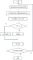
系统提供两种查询模式:在条件查询模块中,用户根据管线类型或者名称可以查询到所有满足条件的管线的所有信息,管线信息以列表的形式显示;在三维场景中,用户直接双击要查看的管线,系统弹出信息显示界面,显示该管线的所有信息。用户可查看的管线信息包括管线名称、类型、规格、敷设日期、维护周期、敷设单位、上次维护日期等。信息查询功能方便用户找到自己所需的数据资料,为管线维护提供数据支持。The system provides two query modes: in the conditional query module, the user can query all the information of all pipelines that meet the conditions according to the pipeline type or name, and the pipeline information is displayed in the form of a list; in the 3D scene, the user directly double-clicks the pipeline to be viewed Pipeline, the system pops up an information display interface to display all information about the pipeline. The pipeline information that users can view includes pipeline name, type, specification, laying date, maintenance cycle, laying unit, last maintenance date, etc. The information query function is convenient for users to find the data they need, and provides data support for pipeline maintenance.
其它对管线个体的非查询操作在对数据库执行的同时,也对配置文件进行,以达到数据库与配置文件同步的目的。Other non-query operations on individual pipelines are performed on the configuration file while executing on the database, so as to achieve the purpose of synchronizing the database and the configuration file.
(3)管线的空间位置移动(3) The spatial position of the pipeline moves
系统提供三种管线移动方式:在“手动方式”下会在管线的两个端点分别生成三维坐标系,拖动其中任意一个坐标系的任意维度,管线该端点就会沿该维度移动相应距离;在“编辑方式”下,系统弹出编辑对话窗口,直接对管线空间数据进行修改,保存后系统重绘视觉窗口,管线移动相应距离;在“整体移动”方式下,系统在管线两端同样分别生成三维坐标系,拖动其中任意一个坐标系的任意维度,管线整体就会沿该维度移动相应距离。这三种模式满足了管线移动的不同需求,同时实现了管线模型的管理。The system provides three pipeline movement methods: in the "manual mode", a three-dimensional coordinate system will be generated at the two endpoints of the pipeline, drag any dimension of any coordinate system, and the endpoint of the pipeline will move a corresponding distance along this dimension; In the "edit mode", the system pops up an edit dialogue window to directly modify the pipeline space data. After saving, the system redraws the visual window, and the pipeline moves the corresponding distance; in the "overall movement" mode, the system also creates Three-dimensional coordinate system, drag any dimension of any coordinate system, and the pipeline as a whole will move the corresponding distance along this dimension. These three modes meet the different requirements of pipeline movement and realize the management of pipeline model at the same time.
二、本发明地铁管线辅助系统的设计方法Two, the design method of subway pipeline auxiliary system of the present invention
本发明基于C/S结构,运用两层架构,如图3所示,即管线信息表示层(UI)与管线业务逻辑层(BLL)结合的综合层和管线数据访问层(DAL)。管线属性信息和管线空间信息分别由SQL SERVER数据库和XML文件存储。因SQL SERVER数据库更易于业务逻辑处理及方便功能扩展,属性信息(如:管线类型、管线名称、管线用途、维护周期等)由SQL数据库存储;XML具有层次结构明确,存取速度快的特点,而在三维漫游过程中需要对数据大量计算处理,要求数据能够快速读取并处理,故管线空间信息数据(如:三维空间坐标以及颜色信息等)由XML文件存储更为适合。The present invention is based on the C/S structure and uses a two-layer architecture, as shown in Figure 3, that is, the pipeline information presentation layer (UI) combined with the pipeline business logic layer (BLL) and the pipeline data access layer (DAL). Pipeline attribute information and pipeline space information are stored by SQL SERVER database and XML file respectively. Because the SQL SERVER database is easier for business logic processing and convenient function expansion, attribute information (such as: pipeline type, pipeline name, pipeline usage, maintenance cycle, etc.) is stored in the SQL database; XML has the characteristics of clear hierarchical structure and fast access speed. In the process of 3D roaming, a large amount of calculation and processing of data is required, and the data is required to be read and processed quickly. Therefore, it is more suitable to store pipeline spatial information data (such as: 3D space coordinates and color information, etc.) in XML files.
管线信息表现层(UI)负责显示三维场景、综合管线模型、管线信息以及各个功能模块的前台界面等,响应用户请求(如管线的查看、定位或者移动等)并交予业务逻辑层处理,为用户提供一种基于三维展示的交互式操作界面。通过表现层,将三维可视化的数据分析结合到管线维护管理的解决方案中;The pipeline information presentation layer (UI) is responsible for displaying 3D scenes, comprehensive pipeline models, pipeline information, and the front-end interface of each functional module, responding to user requests (such as pipeline viewing, positioning, or moving, etc.) and handing over to the business logic layer for processing. The user is provided with an interactive operation interface based on three-dimensional display. Through the presentation layer, combine the data analysis of 3D visualization into the solution of pipeline maintenance management;
管线业务逻辑层(BLL)负责处理用户输入的信息,或者将这些信息发送给数据访问层进行保存,或者是调用数据访问层再次读出这些信息,同时实现对数据的增、删、改、查操作,它提供了整个平台的业务逻辑的支持;The pipeline business logic layer (BLL) is responsible for processing the information input by the user, or sending the information to the data access layer for storage, or calling the data access layer to read the information again, and at the same time realize the addition, deletion, modification and query of data Operation, which provides support for the business logic of the entire platform;
管线数据访问层为表示层与业务逻辑层提供数据支持。通过管线数据访问层(DAL),表示层与业务逻辑层便与SQL SERVER数据库和XML文件进行数据交互,数据库访问层主要通过管线属性信息类访问SQL SERVER数据库、通过管线空间信息类访问XML文件。The pipeline data access layer provides data support for the presentation layer and business logic layer. Through the pipeline data access layer (DAL), the presentation layer and business logic layer interact with the SQL SERVER database and XML files. The database access layer mainly accesses the SQL SERVER database through the pipeline attribute information class, and accesses the XML file through the pipeline space information class.
以下为本发明主要功能模块的实现方法:The following is the implementation method of the main functional modules of the present invention:
1.管线的信息管理:1. Pipeline information management:
管线的查询、添加等操作管理流程如图4至图7所示,按照管线用途,本系统将管线分为若干类型,如:风管(桥架、槽盒)、水管(桥架、槽盒)、配电管(桥架、槽盒)等等。管线个体依赖于管线类型,如:回风管属于风管。每增加一条管线,就在SQL SERVER数据库中增加一条管线数据,再将生成的ID号和录入的空间数据及渲染所需数据写入到配置文件XML中,SQL SERVER数据库中的管线属性信息和XML中的空间信息就通过管线ID号对应起来。至此每条管线的完整信息都被存储起来。删除、修改、查询操作通过对数据库操作都可容易实现。The operation and management process of pipeline query and addition is shown in Figure 4 to Figure 7. According to the purpose of the pipeline, this system divides the pipeline into several types, such as: air duct (bridge frame, tank box), water pipe (bridge frame, tank box), Distribution pipe (bridge, tank box) and so on. The pipeline individual depends on the pipeline type, for example: the return air duct belongs to the air duct. Every time a pipeline is added, add a pipeline data in the SQL SERVER database, and then write the generated ID number, the entered spatial data and the data required for rendering into the configuration file XML, the pipeline attribute information and XML in the SQL SERVER database The spatial information in is mapped to the pipeline ID number. So far the complete information of each pipeline has been stored. Delete, modify, and query operations can be easily realized through database operations.
2.管线的空间定位:2. Spatial positioning of the pipeline:
如图8所示,根据查询到的管线空间信息,把摄像机定位到这条管线所在的位置,并且将管线状态置为选中状态。管线的空间定位必须结合管线的空间信息查询,将管线空间数据提取出来并计算出该段管线的中点坐标,把OpenGL中的摄像机位置放在该段管线的垂直平分线上,高度与中点高度一致,并将摄像机朝向中点,这样定位到的位置即场景摄像机直视该段管线的位置。As shown in Fig. 8, according to the queried pipeline space information, the camera is positioned to the location of the pipeline, and the pipeline status is set to the selected state. The spatial positioning of the pipeline must be combined with the spatial information query of the pipeline, the pipeline space data is extracted and the midpoint coordinates of the pipeline are calculated, and the camera position in OpenGL is placed on the vertical bisector of the pipeline, the height and the midpoint The height is the same, and the camera is directed towards the midpoint, so that the position where the scene camera looks directly at the pipeline.
3.管线碰撞检测:3. Pipeline collision detection:
如图9所示,系统将不同种类的管线的空间信息存储到不同文件中,遍历系统空间数据存储文件所在的文件夹,将管线当作空间直线处理,分别计算不同种类的两条管线间的最短距离,再计算这两条管线的半径和,判断最短距离是否小于两管线的半径和,如果小于则此两条管线发生碰撞。将其中一条再与其它不同种类的所有管线进行判断,循环判断所有管线,并输出判断结果。As shown in Figure 9, the system stores the space information of different types of pipelines in different files, traverses the folders where the system space data storage files are located, treats the pipelines as spatial straight lines, and calculates the distance between two different types of pipelines. The shortest distance, then calculate the sum of the radii of the two pipelines, and judge whether the shortest distance is less than the sum of the radii of the two pipelines, if less, the two pipelines collide. Judge one of them with all other pipelines of different types, judge all pipelines in a loop, and output the judgment result.
4.管线空间位置移动:4. Pipeline spatial position movement:
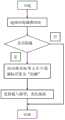
如图10、图12所示,本功能用来将管线的空间数据修改到与实际相符,实现管线空间位置的实时更新。系统提供了三种管线移动模式:手动模式、编辑模式、整体移动。As shown in Figure 10 and Figure 12, this function is used to modify the spatial data of the pipeline to match the actual situation, and realize the real-time update of the spatial position of the pipeline. The system provides three pipeline movement modes: manual mode, edit mode, and overall movement.
手动模式是用户在三维场景中直接拖动管线使管线空间位置发生变化,系统为每段管线的每一端提供了六个自由度的移动。当处于手动模式时,管线端口中心处自动出现六个带箭头的轴,分别指向的方向为:上、下、左、右、前、后,每一个方向的轴代表了这一方向的自由度,用户可以拖动不同的轴以此把管线模型移动到相应方向的位置上,比如拖住向上的箭头拉动管线,则管线的这一端口向上移动,其它方向也是如此,系统记录移动之后管线模型所在的空间位置的数据,并更新到对应的XML文件中。In the manual mode, the user directly drags the pipeline in the 3D scene to change the spatial position of the pipeline. The system provides six degrees of freedom for each end of each pipeline. When in manual mode, six axes with arrows appear automatically at the center of the pipeline port, pointing to the directions: up, down, left, right, front, and back, and the axes in each direction represent the degree of freedom in this direction , the user can drag different axes to move the pipeline model to the position in the corresponding direction. For example, dragging the upward arrow to pull the pipeline, the port of the pipeline will move upward, and the same is true for other directions. The system records the pipeline model after moving The data of the spatial position where it is located is updated to the corresponding XML file.
当处于编辑模式时,用户输入此管线的空间数据坐标对数据,包括起始X坐标、起始Y坐标、起始Z坐标、终点X坐标、终点Y坐标以及终点Z坐标,确定后删除原有管线模型,根据新的空间数据重新绘制管线模型,同时查询此管线所在的XML文件,并更新其空间坐标对数据。When in the editing mode, the user inputs the spatial data coordinate pair data of the pipeline, including the start X coordinate, start Y coordinate, start Z coordinate, end point X coordinate, end point Y coordinate and end point Z coordinate, and delete the existing one after confirmation Pipeline model, redraw the pipeline model according to the new spatial data, and at the same time query the XML file where the pipeline is located, and update its spatial coordinate pair data.
整体移动方式原理与手动移动方式原理一致。移动的时候两个端点同时更改空间位置信息,达到整体移动的效果。The principle of the overall movement mode is consistent with that of the manual movement mode. When moving, the two endpoints change the spatial position information at the same time to achieve the effect of overall movement.
5.场景的三维漫游:5. Three-dimensional roaming of the scene:
本功能根据特定的键盘按键,实现摄像机的前后、左右移动,上下、左右旋转。以达到场景漫游的效果。本系统场景所示图像即为OpenGL中摄像机所摄,所以漫游时只需对场景摄像机进行操作。前进、后退、左右移动只需把摄像机前后左右移动;场景的仰视、俯视,左右浏览,只需上下左右摆动摄像机镜头。This function enables the camera to move back and forth, left and right, and rotate up and down, left and right according to specific keyboard keys. In order to achieve the effect of scene roaming. The image shown in the scene of this system is taken by the camera in OpenGL, so you only need to operate the scene camera when roaming. To move forward, backward, and left and right, you only need to move the camera forward, backward, left, and right; to look up, look down, and browse left and right, you only need to swing the camera lens up, down, left, and right.
6.场景及管线模型管理:6. Scene and pipeline model management:
如图11所示,为了更直观的展示管线和场景的三维空间位置,本系统实现了站层及管线的显隐,便于俯瞰整个场景,可以隐藏不必要的场景结构和同类管线。为了达到此目的,可以将场景切割成若干个场景块,并且将每个场景块和每类管线都做上标记表示是显示还是隐藏。按要求将做显示标记的场景块和管线载入。如果需要隐藏某个场景块或某类管线则将其标记为隐藏。As shown in Figure 11, in order to more intuitively display the three-dimensional space position of the pipeline and the scene, this system realizes the display and hiding of the station layer and the pipeline, which is convenient for overlooking the entire scene, and can hide unnecessary scene structures and similar pipelines. To achieve this, the scene can be divided into several scene blocks, and each scene block and each type of pipeline can be marked to indicate whether to display or hide. Load the scene blocks and pipelines marked for display as required. If you need to hide a scene block or a certain type of pipeline, mark it as hidden.
Claims (6)
Priority Applications (1)
| Application Number | Priority Date | Filing Date | Title |
|---|---|---|---|
| CN201210215714.5ACN102750419B (en) | 2012-06-27 | 2012-06-27 | Subway comprehensive pipeline aided design system and method |
Applications Claiming Priority (1)
| Application Number | Priority Date | Filing Date | Title |
|---|---|---|---|
| CN201210215714.5ACN102750419B (en) | 2012-06-27 | 2012-06-27 | Subway comprehensive pipeline aided design system and method |
Publications (2)
| Publication Number | Publication Date |
|---|---|
| CN102750419Atrue CN102750419A (en) | 2012-10-24 |
| CN102750419B CN102750419B (en) | 2015-03-25 |
Family
ID=47030601
Family Applications (1)
| Application Number | Title | Priority Date | Filing Date |
|---|---|---|---|
| CN201210215714.5AExpired - Fee RelatedCN102750419B (en) | 2012-06-27 | 2012-06-27 | Subway comprehensive pipeline aided design system and method |
Country Status (1)
| Country | Link |
|---|---|
| CN (1) | CN102750419B (en) |
Cited By (11)
| Publication number | Priority date | Publication date | Assignee | Title |
|---|---|---|---|---|
| CN103473412A (en)* | 2013-09-11 | 2013-12-25 | 中铁上海工程局第二工程有限公司 | Subway station roaming method based on virtual and real scenes |
| CN103617314A (en)* | 2013-11-19 | 2014-03-05 | 中铁第四勘察设计院集团有限公司 | Outdoor three-dimensional integrated pipeline threshold detection method for urban rail transit depot |
| CN103679804A (en)* | 2013-12-18 | 2014-03-26 | 中国科学院深圳先进技术研究院 | System and method for automatically building three-dimensional model of data of underground pipeline |
| CN105005095A (en)* | 2015-07-31 | 2015-10-28 | 山东工商学院 | Underground pipeline length and depth measurement system |
| CN107657103A (en)* | 2017-09-19 | 2018-02-02 | 广东电网有限责任公司惠州供电局 | A kind of three-dimensional position modeling method of low-voltage intelligent ammeter |
| CN108416124A (en)* | 2018-02-13 | 2018-08-17 | 西安理工大学 | A kind of specification reconstruct representation method based on predicate logic |
| CN109063382A (en)* | 2018-09-17 | 2018-12-21 | 江苏舒适云信息技术有限公司 | A kind of room ground heating pipe designing system |
| CN109426882A (en)* | 2017-08-25 | 2019-03-05 | 苏州织巢信息科技有限公司 | Fit up layout of roads method, apparatus and terminal |
| CN110737684A (en)* | 2019-04-22 | 2020-01-31 | 北京瀚方伟业工程技术有限公司 | Information processing device for assembled electromechanical pipeline layout detection |
| CN111241622A (en)* | 2020-01-19 | 2020-06-05 | 杭州群核信息技术有限公司 | Self-adaptive water heating electric pipeline adjusting system and method |
| CN118296685A (en)* | 2024-06-06 | 2024-07-05 | 青岛华正信息技术股份有限公司 | System for intelligent planning pipeline based on CAD drawing |
Families Citing this family (1)
| Publication number | Priority date | Publication date | Assignee | Title |
|---|---|---|---|---|
| CN105760626B (en)* | 2016-03-21 | 2018-11-23 | 北京交通大学 | The pipeline route figure at new subway station generates system and method |
Citations (4)
| Publication number | Priority date | Publication date | Assignee | Title |
|---|---|---|---|---|
| US6678874B1 (en)* | 2001-11-28 | 2004-01-13 | Unisys Corporation | Computer-aided design (CAD) tool |
| CN101515346A (en)* | 2009-03-16 | 2009-08-26 | 浙江大学 | Nursing control management controlling system |
| CN102157014A (en)* | 2011-04-13 | 2011-08-17 | 西安理工大学 | Method for three-dimensional visualization of comprehensive pipeline of metro |
| CN102201129A (en)* | 2011-04-25 | 2011-09-28 | 西安理工大学 | Three-dimensional visual operation maintenance system and method of subway comprehensive pipelines |
- 2012
- 2012-06-27CNCN201210215714.5Apatent/CN102750419B/ennot_activeExpired - Fee Related
Patent Citations (4)
| Publication number | Priority date | Publication date | Assignee | Title |
|---|---|---|---|---|
| US6678874B1 (en)* | 2001-11-28 | 2004-01-13 | Unisys Corporation | Computer-aided design (CAD) tool |
| CN101515346A (en)* | 2009-03-16 | 2009-08-26 | 浙江大学 | Nursing control management controlling system |
| CN102157014A (en)* | 2011-04-13 | 2011-08-17 | 西安理工大学 | Method for three-dimensional visualization of comprehensive pipeline of metro |
| CN102201129A (en)* | 2011-04-25 | 2011-09-28 | 西安理工大学 | Three-dimensional visual operation maintenance system and method of subway comprehensive pipelines |
Non-Patent Citations (2)
| Title |
|---|
| 王淑嫱 等: "地铁车站综合管网三维冲突分析系统功能设计与实现", 《武汉理工大学学报》* |
| 祖明: "基于Web的虚拟协同漫游技术的研究与实现", 《中国优秀硕士学位论文全文数据库(电子期刊)—信息科技辑》* |
Cited By (18)
| Publication number | Priority date | Publication date | Assignee | Title |
|---|---|---|---|---|
| CN103473412B (en)* | 2013-09-11 | 2017-02-22 | 中铁上海工程局集团第二工程有限公司 | Subway station roaming method based on virtual and real scenes |
| CN103473412A (en)* | 2013-09-11 | 2013-12-25 | 中铁上海工程局第二工程有限公司 | Subway station roaming method based on virtual and real scenes |
| CN103617314A (en)* | 2013-11-19 | 2014-03-05 | 中铁第四勘察设计院集团有限公司 | Outdoor three-dimensional integrated pipeline threshold detection method for urban rail transit depot |
| CN103617314B (en)* | 2013-11-19 | 2017-11-03 | 中铁第四勘察设计院集团有限公司 | The method of pipeline collision detection in the outdoor three-dimensional comprehensive pipeline designs of rail traffic vehicles section |
| CN103679804A (en)* | 2013-12-18 | 2014-03-26 | 中国科学院深圳先进技术研究院 | System and method for automatically building three-dimensional model of data of underground pipeline |
| CN105005095A (en)* | 2015-07-31 | 2015-10-28 | 山东工商学院 | Underground pipeline length and depth measurement system |
| CN105005095B (en)* | 2015-07-31 | 2018-04-13 | 山东工商学院 | Underground utilities length, depth-measuring system |
| CN109426882A (en)* | 2017-08-25 | 2019-03-05 | 苏州织巢信息科技有限公司 | Fit up layout of roads method, apparatus and terminal |
| CN109426882B (en)* | 2017-08-25 | 2021-02-26 | 苏州织巢信息科技有限公司 | Decoration line planning method and device and terminal |
| CN107657103A (en)* | 2017-09-19 | 2018-02-02 | 广东电网有限责任公司惠州供电局 | A kind of three-dimensional position modeling method of low-voltage intelligent ammeter |
| CN108416124A (en)* | 2018-02-13 | 2018-08-17 | 西安理工大学 | A kind of specification reconstruct representation method based on predicate logic |
| CN109063382B (en)* | 2018-09-17 | 2019-09-27 | 江苏舒适云信息技术有限公司 | A kind of room ground heating pipe designing system |
| CN109063382A (en)* | 2018-09-17 | 2018-12-21 | 江苏舒适云信息技术有限公司 | A kind of room ground heating pipe designing system |
| CN110737684A (en)* | 2019-04-22 | 2020-01-31 | 北京瀚方伟业工程技术有限公司 | Information processing device for assembled electromechanical pipeline layout detection |
| CN110737684B (en)* | 2019-04-22 | 2022-03-18 | 北京瀚方伟业工程技术有限公司 | An information processing device for prefabricated electromechanical pipeline layout detection |
| CN111241622A (en)* | 2020-01-19 | 2020-06-05 | 杭州群核信息技术有限公司 | Self-adaptive water heating electric pipeline adjusting system and method |
| CN118296685A (en)* | 2024-06-06 | 2024-07-05 | 青岛华正信息技术股份有限公司 | System for intelligent planning pipeline based on CAD drawing |
| CN118296685B (en)* | 2024-06-06 | 2024-09-10 | 青岛华正信息技术股份有限公司 | System for intelligent planning pipeline based on CAD drawing |
Also Published As
| Publication number | Publication date |
|---|---|
| CN102750419B (en) | 2015-03-25 |
Similar Documents
| Publication | Publication Date | Title |
|---|---|---|
| CN102750419B (en) | Subway comprehensive pipeline aided design system and method | |
| CN102201129B (en) | Three-dimensional visual operation maintenance system and method of subway comprehensive pipelines | |
| CN102750618B (en) | A kind of comprehensive pipeline of metro construction aided management system and implementation method | |
| Liu | Three-dimensional visualized urban landscape planning and design based on virtual reality technology | |
| CN109887084B (en) | Method for urban planning by using immersed virtual reality technology | |
| CN102157014B (en) | Method for three-dimensional visualization of comprehensive pipeline of metro | |
| CN102509330B (en) | Application of virtual three-dimensional system of transformer substation on the basis of electric power geographic information system (GIS) | |
| CN104392482B (en) | Substation project project three-dimensional calculation amount model generation system and method | |
| CN102508991B (en) | Method of constructing virtual experiment teaching scene based on image material | |
| CN107423458A (en) | Steel manufacture process analogue system | |
| CN101154295A (en) | Three-dimensional simulation electronic map for navigation channel | |
| CN102253981A (en) | Method for rapidly displaying and browsing massive models of three-dimensional geographic information system | |
| CN102799714A (en) | Method for extracting data of integrated pipeline of metro based on Auto computer-aided design (CAD) drawing | |
| CN118429541A (en) | Industrial big data application scene construction method combining three-dimensional digital twin model | |
| CN116484037A (en) | High-precision map data acquisition method, system, electronic device and storage medium | |
| Hao et al. | Integrated BIM and VR to implement IPD mode in transportation infrastructure projects: System design and case application | |
| Xu et al. | Research for 3D visualization of Digital City based on SketchUp and ArcGIS | |
| CN111523161A (en) | BIM and Unity 3D-based 3D Internet of things visualization man-machine interaction method | |
| Tsai et al. | Integration of BIM and GIS to query management on pipeline of building-a case study of dormitory | |
| He et al. | Assistant design system of urban underground pipeline based on 3D virtual city | |
| Fan | Design of 3D Interactive Landscape Roaming Algorithm Based on Deep Learning Technology | |
| CN119293902B (en) | Bridge position selection auxiliary method based on BIM and GIS | |
| Chen et al. | Research on Interior Design Simulation Operating System Based on Virtual Reality | |
| Jiang | Using untiy 3d game development platform to develop low cost online real estate display system | |
| Liu et al. | The realization of virtual city roaming based on vage |
Legal Events
| Date | Code | Title | Description |
|---|---|---|---|
| C06 | Publication | ||
| PB01 | Publication | ||
| C10 | Entry into substantive examination | ||
| SE01 | Entry into force of request for substantive examination | ||
| C14 | Grant of patent or utility model | ||
| GR01 | Patent grant | ||
| CF01 | Termination of patent right due to non-payment of annual fee | ||
| CF01 | Termination of patent right due to non-payment of annual fee | Granted publication date:20150325 |