CN102646333A - Detection information management system, vehicle terminal, and detection information management device - Google Patents
Detection information management system, vehicle terminal, and detection information management deviceDownload PDFInfo
- Publication number
- CN102646333A CN102646333ACN201210033937XACN201210033937ACN102646333ACN 102646333 ACN102646333 ACN 102646333ACN 201210033937X ACN201210033937X ACN 201210033937XACN 201210033937 ACN201210033937 ACN 201210033937ACN 102646333 ACN102646333 ACN 102646333A
- Authority
- CN
- China
- Prior art keywords
- road
- information
- detection information
- collected
- car
- Prior art date
- Legal status (The legal status is an assumption and is not a legal conclusion. Google has not performed a legal analysis and makes no representation as to the accuracy of the status listed.)
- Pending
Links
Images


Classifications
- G—PHYSICS
- G08—SIGNALLING
- G08G—TRAFFIC CONTROL SYSTEMS
- G08G1/00—Traffic control systems for road vehicles
- G08G1/01—Detecting movement of traffic to be counted or controlled
- G08G1/0104—Measuring and analyzing of parameters relative to traffic conditions
- G08G1/0125—Traffic data processing
- G08G1/0129—Traffic data processing for creating historical data or processing based on historical data
- G—PHYSICS
- G08—SIGNALLING
- G08G—TRAFFIC CONTROL SYSTEMS
- G08G1/00—Traffic control systems for road vehicles
- G08G1/01—Detecting movement of traffic to be counted or controlled
- G08G1/0104—Measuring and analyzing of parameters relative to traffic conditions
- G08G1/0108—Measuring and analyzing of parameters relative to traffic conditions based on the source of data
- G08G1/0112—Measuring and analyzing of parameters relative to traffic conditions based on the source of data from the vehicle, e.g. floating car data [FCD]
- G—PHYSICS
- G08—SIGNALLING
- G08G—TRAFFIC CONTROL SYSTEMS
- G08G1/00—Traffic control systems for road vehicles
- G08G1/01—Detecting movement of traffic to be counted or controlled
- G08G1/0104—Measuring and analyzing of parameters relative to traffic conditions
- G08G1/0125—Traffic data processing
- G08G1/0133—Traffic data processing for classifying traffic situation
- G—PHYSICS
- G08—SIGNALLING
- G08G—TRAFFIC CONTROL SYSTEMS
- G08G1/00—Traffic control systems for road vehicles
- G08G1/01—Detecting movement of traffic to be counted or controlled
- G08G1/0104—Measuring and analyzing of parameters relative to traffic conditions
- G08G1/0137—Measuring and analyzing of parameters relative to traffic conditions for specific applications
- G08G1/0141—Measuring and analyzing of parameters relative to traffic conditions for specific applications for traffic information dissemination
Landscapes
- Chemical & Material Sciences (AREA)
- Analytical Chemistry (AREA)
- Physics & Mathematics (AREA)
- General Physics & Mathematics (AREA)
- Traffic Control Systems (AREA)
- Instructional Devices (AREA)
- Navigation (AREA)
Abstract
Translated fromChinese
Description
Translated fromChinese技术领域technical field
本发明涉及探测信息管理系统、车载终端、及探测信息管理装置。The invention relates to a detection information management system, a vehicle-mounted terminal, and a detection information management device.
背景技术Background technique
以往,已知如下的探测信息管理装置:收集包含从车辆侧发送来的该车辆的位置信息和行驶信息等的探测信息并进行统计处理,从而制作交通堵塞信息等道路交通信息。但是,在上述的探测信息管理装置中存在以下问题,对于车辆的行驶辆数较少的道路,无法得到统计处理所需要的辆数的探测信息,无法制作精度较高的道路交通信息。Conventionally, there is known a probe information management device that collects probe information including position information and travel information of the vehicle transmitted from the vehicle side, performs statistical processing, and generates road traffic information such as traffic congestion information. However, the probe information management device described above has a problem that, for roads with a small number of vehicles, probe information of the number of vehicles required for statistical processing cannot be obtained, and highly accurate road traffic information cannot be created.
在此,作为解决该问题的方法,例如在专利文献1中公开有如下技术:提取探测信息较少的地域(少数地域),将提取的少数地域的信息发送给车辆侧,并且在从车辆侧接收少数地域的探测信息时对车辆侧提供规定的服务,从而促使少数地域的行驶,减少成为少数地域的地域。Here, as a method of solving this problem, for example, Patent Document 1 discloses a technique of extracting areas with less probe information (a small number of areas), transmitting the information of the extracted few areas to the vehicle side, and transmitting the information from the vehicle side When the detection information of a minority area is received, a predetermined service is provided to the vehicle side, thereby promoting driving in a minority area and reducing the number of areas becoming a minority area.
专利文献1:日本特开2009-93560号公报Patent Document 1: Japanese Patent Laid-Open No. 2009-93560
通常,在车辆侧逐次储存探测信息,在每规定的时间或每当在各路段的行驶等规定的定时,不断向探测信息管理装置发送储存的探测信息。因此,在专利文献1公开的技术中存在以下问题:即使是已经得到了统计处理所需要的辆数的探测信息的地域的探测信息,也向探测信息管理装置持续发送,对车辆侧及探测信息管理装置侧这两者来说,花费多余的通信成本。Usually, the probe information is sequentially stored on the vehicle side, and the stored probe information is continuously sent to the probe information management device at a predetermined timing such as every predetermined time or every time the vehicle travels on each link. Therefore, in the technique disclosed in Patent Document 1, there is a problem that even the probe information of an area for which the probe information of the number of vehicles required for statistical processing has been obtained is continuously sent to the probe information management device, and the vehicle side and the probe information On both sides of the management device, unnecessary communication costs are incurred.
发明内容Contents of the invention
本发明是鉴于上述以往的问题点而做出的,其目的在于,提供一种能够抑制探测信息的收集中的多余的通信成本的探测信息管理系统、车载终端、及探测信息管理装置。The present invention has been made in view of the aforementioned conventional problems, and an object of the present invention is to provide a probe information management system, an in-vehicle terminal, and a probe information management device capable of suppressing unnecessary communication costs in collecting probe information.
在作为本发明的第一观点的探测信息管理系统中,探测信息管理装置具备判别部,基于从车载终端收集的探测信息,判别已收集道路和未收集道路,所述已收集道路是指已收集了制作道路交通信息所需要的量的探测信息的道路,所述未收集道路是指尚未收集制作道路交通信息所需要的量的探测信息的道路,将由判别部判别的已收集道路及未收集道路的信息发送给车载终端,车载终端基于从探测信息管理装置发送来的已收集道路及未收集道路的信息,不向探测信息管理装置发送已收集道路的探测信息。In the probe information management system as the first aspect of the present invention, the probe information management device is provided with a judging unit for discriminating between collected roads and uncollected roads based on probe information collected from an in-vehicle terminal. A road for which the probe information required for creating the road traffic information has been collected, the uncollected road is a road for which the probe information required for creating the road traffic information has not yet been collected, and the collected road and the uncollected road identified by the determination unit The vehicle-mounted terminal does not send the probe information of the collected roads to the probe information management device based on the collected road and uncollected road information sent from the probe information management device.
此外,在作为本发明的第二观点的探测信息管理系统中,探测信息管理装置具备判别部,基于从车载终端收集的探测信息,判别已收集道路和未收集道路,所述已收集道路是指已收集了制作道路交通信息所需要的量的探测信息的道路,所述未收集道路是指尚未收集制作道路交通信息所需要的量的探测信息的道路,将由判别部判别的已收集道路及未收集道路的信息中的至少未收集道路的信息发送给车载终端,并发送发送限制指示,该发送限制指示是使车载终端不进行已收集道路的探测信息的发送的指示,车载终端基于从探测信息管理装置发送来的发送限制指示,不向探测信息管理装置发送已收集道路的探测信息。Furthermore, in the probe information management system as the second aspect of the present invention, the probe information management device includes a discrimination unit for discriminating between collected roads and uncollected roads based on probe information collected from an in-vehicle terminal. A road on which the probe information required for creating road traffic information has been collected, and the uncollected road refers to a road for which the probe information required for creating road traffic information has not been collected. Among the collected road information, at least information on uncollected roads is sent to the vehicle-mounted terminal, and a transmission restriction instruction is sent. The transmission restriction instruction is an instruction to prevent the vehicle-mounted terminal from sending the probe information of the collected roads. The transmission restriction instruction sent from the management device does not transmit the collected probe information of the road to the probe information management device.
根据上述第一及第二观点的结构,不从车载终端向探测信息管理装置发送已收集了制作道路交通信息所需要的量的探测信息的道路的探测信息,所以不花费对车载终端及探测信息管理装置的两者来说多余的通信成本。因此,能够抑制探测信息的收集中的多余的通信成本。According to the structure of the above-mentioned first and second viewpoints, the probe information of the road for which the amount of probe information required to create road traffic information has been collected is not sent from the vehicle-mounted terminal to the probe information management device, so it does not cost the vehicle-mounted terminal and the probe information. Excessive communication costs for both of the management devices. Therefore, unnecessary communication costs in collecting probe information can be suppressed.
作为第三观点,在车载终端的显示器上的电子地图上将未收集道路与已收集道路可区分地显示,所以用户能够辨别未收集道路。此外,通过由用户辨别未收集道路,能够促使在尚未收集制作道路交通信息所需要的量的探测信息的道路的行驶。As a third viewpoint, the uncollected roads and the collected roads are displayed on the electronic map on the display of the in-vehicle terminal in a distinguishable manner, so that the user can distinguish the uncollected roads. In addition, by allowing the user to identify an uncollected road, it is possible to promote travel on a road for which the amount of probe information required for creating road traffic information has not yet been collected.
作为第四观点,在从车载终端接收未收集道路的探测信息时,探测信息管理装置对该车载终端提供规定的服务,所以通过服务的提供来给予用户利益,从而能够进一步促使在尚未收集制作道路交通信息所需要的量的探测信息的道路的行驶。As a fourth point of view, when receiving probe information of uncollected roads from an in-vehicle terminal, the probe information management device provides a predetermined service to the in-vehicle terminal. Therefore, the provision of the service provides benefits to the user, thereby further promoting roads that have not yet been collected. The amount of probe information necessary for traffic information for road travel.
在作为第五观点的车载终端中,接收由探测信息管理装置基于探测信息判别并从探测信息管理装置发送来的已收集道路和未收集道路的信息,所述已收集道路是指已收集了制作道路交通信息所需要的量的探测信息的道路,所述未收集道路是指尚未收集制作道路交通信息所需要的量的探测信息的道路,基于从探测信息管理装置发送来的已收集道路及未收集道路的信息,不向探测信息管理装置发送已收集道路的探测信息。In the vehicle-mounted terminal as a fifth aspect, information on collected roads and uncollected roads, which are discriminated based on the probe information by the probe information management device and sent from the probe information management device, is received. Roads for which the amount of probe information required for road traffic information has not been collected. The road information is collected, and the collected road detection information is not sent to the detection information management device.
由此,车载终端不向探测信息管理装置发送已收集了制作道路交通信息所需要的量的探测信息的道路的探测信息,所以能够抑制探测信息的收集中的多余的通信成本。As a result, the in-vehicle terminal does not transmit the probe information of the road for which the amount of probe information required for creating road traffic information has already been collected to the probe information management device, so that unnecessary communication costs in collecting the probe information can be suppressed.
在作为第六观点的探测信息管理装置中,具备判别部,基于从车载终端收集的探测信息,判别已收集道路和未收集道路,所述已收集道路是指已收集了制作道路交通信息所需要的量的探测信息的道路,所述未收集道路是指尚未收集制作道路交通信息所需要的量的探测信息的道路,将由判别部判别的已收集道路及未收集道路的信息中的至少未收集道路的信息发送给车载终端,并发送发送限制指示,该发送限制指示是使车载终端不进行已收集道路的探测信息的发送的指示。In the probe information management device as a sixth aspect, a discrimination unit is provided for discriminating between collected roads and non-collected roads based on probe information collected from an in-vehicle terminal. The roads with a certain amount of probe information, the uncollected roads refer to roads for which the amount of probe information required for making road traffic information has not been collected, and at least one of the collected roads and uncollected road information discriminated by the determination unit has not been collected. The road information is sent to the in-vehicle terminal, and a transmission restriction instruction is sent to prevent the in-vehicle terminal from transmitting the collected road probe information.
由此,探测信息管理装置使得不从车载终端向探测信息管理装置发送已收集了制作道路交通信息所需要的量的探测信息的道路的探测信息,所以能够抑制探测信息的收集中的多余的通信成本。As a result, the probe information management device does not transmit the probe information of the road for which the probe information required for creating road traffic information has already been collected from the in-vehicle terminal to the probe information management device, so redundant communication during the collection of probe information can be suppressed. cost.
附图说明Description of drawings
图1是表示探测信息管理系统100的概略结构的框图。FIG. 1 is a block diagram showing a schematic configuration of a probe
图2是表示导航装置2的概略结构的框图。FIG. 2 is a block diagram showing a schematic configuration of the navigation device 2 .
图3是表示VICS中心3的概略结构的框图。FIG. 3 is a block diagram showing a schematic configuration of the VICS
图4是表示探测信息的收集状况的信息的一例的示意图。FIG. 4 is a schematic diagram showing an example of information on the collection status of probe information.
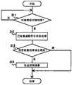
图5是表示VICS中心3中的、到收集状况信息的发送为止的处理的流程的一例的流程图。FIG. 5 is a flowchart showing an example of a flow of processing in the VICS
图6是用于说明道路颜色变更处理的示意图。FIG. 6 is a schematic diagram for explaining road color change processing.
图7是表示与导航装置1中的探测信息发送限制处理相关的处理的流程的一例的流程图。FIG. 7 is a flowchart showing an example of a flow of processing related to probe information transmission restriction processing in the navigation device 1 .
具体实施方式Detailed ways
以下使用附图说明本发明的实施方式。Embodiments of the present invention will be described below using the drawings.
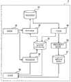
图1是表示应用了本发明的探测信息管理系统100的概略结构的框图。图1所示的探测信息管理系统100包括导航装置1及VICS(注册商标)中心3。FIG. 1 is a block diagram showing a schematic configuration of a probe
导航装置1除了路径检索和路径引导等周知的导航功能之外,还具备探测信息的收集功能。在此,使用图2说明导航装置1的概略结构。图2是表示导航装置1的概略结构的框图。如图2所示,导航装置1具备:位置检测器11、地图数据输入器16、存储介质17、外部存储器18、显示装置19、声音输出装置20、声音辨别单元21、操作开关组22、遥感控制终端(以下称为遥控器)23、遥控传感器24、收发机25、及控制装置26。另外,导航装置1相当于车载终端。The navigation device 1 includes a function of collecting probe information in addition to well-known navigation functions such as route search and route guidance. Here, the schematic structure of the navigation apparatus 1 is demonstrated using FIG. 2. FIG. FIG. 2 is a block diagram showing a schematic configuration of the navigation device 1 . As shown in Figure 2, the navigation device 1 is equipped with: a
位置检测器11具有:陀螺仪12,检测自车辆绕着铅垂方向的角速度;加速度传感器13,检测自车辆的加速度;车轮速传感器14,根据各转动轮的旋转速度检测自车辆的速度;及用于GPS(Global Positioning System)的GPS接收机15,基于来自人造卫星的电波检测车辆的当前位置;该位置检测器11定期地进行自车辆的当前位置的检测。The
这些各传感器12~15分别具有性质不同的误差,所以构成为通过多个传感器分别校正而使用。另外,根据精度,可以由上述的一部分构成,也可以还使用未图示的地磁传感器和转向的旋转传感器等。Each of these sensors 12 to 15 has an error of a different nature, so it is configured to be calibrated and used by a plurality of sensors. In addition, depending on the accuracy, it may be composed of a part of the above, and a geomagnetic sensor, a steering rotation sensor, etc. not shown may also be used.
地图数据输入器16安装有存储介质17,是用于输入包含保存在该存储介质17中的地图数据在内的各种数据的装置。地图数据中包含表示道路的路段数据和节点数据。另外,路段是指,将地图上的各道路通过交叉·分支·合流的点等多个节点分割时的、将节点间连结的段,通过将各路段连接而构成道路。路段数据由下列各数据构成:用于确定路段的固有号码(路段ID)、表示路段的长度的路段长、路段方向、路段方位、路段的起点及终点节点坐标(纬度·经度)、道路名称、道路种类、单向通行属性、道路宽度、车道数、右转·左转专用车道的有无及该专用车道的数量、及限制速度等。The map
另一方面,节点数据由下列各数据构成:对地图上的各道路交叉、合流、分支的节点的每一个赋予固有号码的节点ID、节点坐标、节点名称、记述有与节点连接的路段的路段ID的连接路段ID、及交叉点种类等。On the other hand, the node data is composed of the following data: a node ID with a unique number assigned to each node of each road intersection, merging, and branching on the map, node coordinates, node name, and a link in which a link connected to the node is described. Link link IDs of IDs, types of intersections, and the like.
此外,在存储介质17中存储有各种设施的种类、名称、住所的数据等,这些数据用于路径检索时的目的地设定等。另外,作为存储介质17,使用CD-ROM或DVD-ROM、存储器卡、HDD等。In addition, the storage medium 17 stores data such as types, names, and addresses of various facilities, and these data are used for destination setting and the like at the time of route search. In addition, as the storage medium 17, a CD-ROM or DVD-ROM, a memory card, an HDD, or the like is used.
外部存储器18是HDD等可写入的大容量存储装置。外部存储器18有如下用途:存储大量数据和即使关闭电源也不可以删除的数据,或从地图数据输入器16拷贝并利用频繁使用的数据等。The
显示装置19显示用于引导车辆的行驶的地图等,例如能够全彩显示,可以使用液晶显示屏、有机EL显示屏、等离子显示屏等来构成。另外,显示装置19相当于显示器。声音输出装置20由扬声器等构成,基于控制装置26的指示输出路径引导时的引导声音等。声音辨别单元21辨别从未图示的送话器输入的声音,向控制装置26输出与该辨别的声音对应的控制指令。在控制装置26中,按照该控制指令执行处理。The
操作开关组22例如使用与显示装置19成为一体的触摸开关或机械开关等,通过开关操作向控制装置26进行各种功能的操作指示。在遥控器23中设有多个操作开关(未图示),通过开关操作,经由遥控传感器24向控制装置26输入各种指令信号,从而能够对控制装置26执行与操作开关组22相同的功能。The
收发机25接收从VICS中心经由架设在网络或道路中的信标及各地的FM广播站发布来的道路交通信息等信息。此外,收发机25按照控制装置26的指示,将通过探测信息的收集功能收集的探测信息向外部(在本实施方式中为VICS中心3)发送。另外,从收发机25向VICS中心3的探测信息的发送可以采用通过例如DCM(data communication module)等用于远距离通信的车载通信模块来进行的结构,也可以采用通过例如以蓝牙(注册商标)等连接的便携式电话机进行的结构。此外,可以采用通过DSRC通信用模块来进行的结构,也可以采用通过其他无线通信用模块来进行的结构。The
控制装置26以由CPU、ROM、RAM、备份RAM等构成的微型计算机为主体来构成。并且,控制装置26基于从位置检测器11、地图数据输入器16、外部存储器18、声音辨别单元21、操作开关组22、遥控传感器24、收发机25输入的各种信息,执行作为导航功能的处理、作为探测信息的收集功能的处理(以下称为探测信息收集处理)、探测信息的发送处理(以下称为探测信息发送处理)、地图上的道路颜色的变更处理(以下称为道路颜色变更处理)、探测信息的发送限制处理(以下称为探测信息发送限制处理)等。The
在探测信息收集处理中,收集以下探测信息:从加速度传感器13得到的加减速的信息、从车轮速传感器14得到的行驶速度的信息、通过导航功能得到的行驶轨迹的信息、从制动ECU等得到的ABS等制动系统的动作状况的信息、从雨刷开关得到的雨刷的动作状况的信息等车辆的行驶信息;以及根据由位置检测器11检测到的当前位置决定的行驶位置的信息(位置信息)。将收集到的探测信息与行驶信息、得到该行驶信息的行驶位置的信息、得到该行驶信息的日期时间等时间信息建立关联,并储存到外部存储器18等存储器中。对于时间信息,可以采用利用未图示的计时器电路或经由GPS接收机15从GPS卫星得到的时间信息等的结构。In the detection information collection process, the following detection information is collected: acceleration and deceleration information obtained from the
探测信息可以采用例如以道路区间为单位来处理的结构。这种情况下,对于与自车辆的过去的行驶路径对应的多个道路区间的每一个,将能够确定各道路区间的位置信息(例如道路区间的始点的经纬度及终点的经纬度的信息)、该道路区间的行驶信息、在该道路区间内行驶的日期时间的信息建立关联并储存。另外,也可以采用将上述的路段作为道路区间的单位的结构。这种情况下,也可以采用将路段ID作为位置信息使来用的结构。在本实施方式中,举出以路段为单位来处理探测信息的情况为例进行以后的说明。Probe information can be processed in units of road sections, for example. In this case, for each of a plurality of road sections corresponding to the past travel route of the ego vehicle, position information of each road section (for example, information on the latitude and longitude of the starting point of the road section and the latitude and longitude of the end point), the The driving information of the road section and the information of the date and time of driving in the road section are associated and stored. In addition, a configuration in which the above-mentioned link is used as a unit of a road section may also be employed. In this case, it is also possible to employ a configuration in which the link ID is used as position information. In the present embodiment, a case where probe information is processed in units of links is taken as an example for the following description.
在探测信息发送处理中,在通过探测信息收集处理收集并储存的探测信息中附加用于确定搭载有导航装置1的车辆的识别信息(例如车辆或导航装置1的ID),以规定的定时从收发机25向VICS中心3发送。这里所述的规定的定时可以是例如每5分钟等每一定的时间,也可以是每当在各路段的行驶或每一定的行驶距离。在本实施方式中,举出每当在各路段的行驶来发送探测信息的情况为例进行以后的说明。此外,关于道路颜色变更处理及探测信息发送限制处理,在后面详细叙述。In the probe information transmission process, identification information for specifying the vehicle on which the navigation device 1 is mounted (for example, the ID of the vehicle or the navigation device 1 ) is added to the probe information collected and stored in the probe information collection process, and is transmitted from The
回到图1,VICS中心3是设置在地上的基站,由服务器构成。构成VICS中心3的服务器相当于探测信息管理装置。并且,VICS中心3经由架设在网络或道路上的信标或各地的FM广播站发送(发布)以下道路交通信息:表示交通堵塞的程度的交通堵塞度的信息、表示通行所需要的时间的区间所要时间的信息(即路段旅行时间的信息)、因事故或工事等而禁止通行等的交通阻碍的信息、禁止通行或临时限制等交通限制的信息等。此外,VICS中心3通过接收来收集从多个车辆的导航装置1发送来的探测信息,并对收集的探测信息进行统计处理,从而制作道路交通信息。Returning to Fig. 1, the
另外,VICS中心3可以由1个服务器构成,也可以由多个服务器构成。例如,可以采用分别设置制作并发布道路交通信息的服务器和收集探测信息的服务器。In addition, the
在此,使用图3说明VICS中心3的概略结构。图3是表示VICS中心3的概略结构的框图。如图3所示,VICS中心3具备:接收部31、保存控制部32、探测信息数据库(DB)33、判别部34、信息收集状况保存部35、道路交通信息制作部36、道路交通信息数据库(DB)37、发送部38、及服务提供部39。Here, the schematic structure of the
接收部31接收从导航装置1发送来的探测信息。保存控制部32将接收部31接收的探测信息保存在探测信息DB33中。每当由接收部31接收到新的探测信息,保存控制部32就将接收到的探测信息保存在探测信息DB33中,从而将探测信息储存在探测信息DB33中。另外,储存在探测信息DB33中的探测信息也可以构成为,从例如在导航装置1中的收集时或在接收部31中的接收时等起,从经过了1日以上的数据等经过了规定时间的数据开始删除。The receiving
判别部34基于储存在探测信息DB33中的探测信息,对于各路段(即各道路)判别是否已收集了用于制作道路交通信息的统计处理所需要的量(以下称为统计处理需要量)的探测信息(以下将该处理称为统计处理需要量到达判别处理)。这里所说的统计处理需要量表示为了制作精度较高的道路交通信息而在统计学上需要的探测信息的采样数,是可以根据要求的精度任意设定的值。Based on the probe information stored in the
并且,判别部34在判别为作为对象的路段的探测信息的采样数满足统计处理需要量的情况下,将表示对于该路段结束了探测信息的收集的信息收集结束标志设为有效。此外,在未判别为作为对象的路段的探测信息的采样数满足统计处理需要量的情况下,将表示对于该路段已结束探测信息的收集的信息收集结束标志设为默认的无效。即,判别部34判别统计处理需要量的探测信息已收集的路段(即已收集道路)和统计处理需要量的探测信息未收集的路段(即未收集道路)。Then, when it is judged that the number of samples of probe information of the target link satisfies the amount required for statistical processing, the
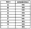
因此,判别部34将各路段的信息收集结束标志的有效无效的信息作为探测信息的收集状况的信息(以下称为收集状况信息)保存在信息收集状况保存部35中。作为一例,如图4所示,可以采用如下结构:用表将路段ID和信息收集结束标志的有效无效的信息建立关联,并将该表作为收集状况信息保存在信息收集状况保存部35中。图4是表示探测信息的收集状况的信息的一例的示意图。Therefore, the
另外,在图4的例中,对于路段ID“A”~“E”,以及“G”~“I”的路段,信息收集结束标志为有效,对于路段ID“F”的路段,信息收集结束标志为无效。这表示,对于路段ID“A”~“E”,以及“G”~“I”的道路,已收集了制作道路交通信息所需要的量的探测信息,对于路段ID“F”的道路,尚未收集制作道路交通信息所需要的量的探测信息。In addition, in the example of FIG. 4, for the link IDs "A" to "E" and "G" to "I", the information collection end flag is valid, and for the link ID "F", the information collection is completed. flag is invalid. This means that for roads with link IDs "A" to "E" and roads "G" to "I", the amount of probe information required for making road traffic information has been collected, and for roads with link ID "F", the probe information has not yet been collected. The amount of probe information required to create road traffic information is collected.
道路交通信息制作部36对于在判别部34的判别中被判别为探测信息的采样数满足统计处理需要量的路段,通过对储存在探测信息DB33中的、从多个车辆的导航装置1提供来的探测信息进行统计处理,制作道路交通信息。作为对探测信息进行统计处理而制作道路交通信息的方法,采用使用公知的方法的结构即可。道路交通信息制作部36将制作的道路交通信息保存在道路交通信息DB37中。The road traffic
另外,道路交通信息制作部36不限于从导航装置1接受提供的探测信息,也可以使用从都道府县警察或道路管理者等接受提供的道路交通信息来制作道路交通信息。In addition, the road traffic
发送部38将保存在道路交通信息DB37中的道路交通信息向导航装置1发送。例如,在经由信标或FM广播站发布的情况下,可以将道路交通信息以每规定的周期发送,在经由网络发布的情况下,可以在有来自导航装置1侧的请求时发送道路交通信息。此外,发送部38发送道路交通信息时,将保存在信息收集状况保存部35中的收集状况信息也向导航装置1发送。The transmitting
在此,使用图5说明VICS中心3中的、到收集状况信息的发送为止的处理的流程。图5是表示VICS中心3中的、到收集状况信息的发送为止的处理的流程的一例的流程图。图5所示的流程为,在由接收部31接收探测信息并将新的探测信息保存到探测信息DB33中时开始,对各路段依次进行处理。Here, the flow of processing up to transmission of the collection status information in the
在步骤S1中,对于作为对象的路段,判别部34进行上述的统计处理需要量到达判别处理,转移到步骤S2。在步骤S2中,在判别为作为对象的路段的探测信息的采样数满足统计处理需要量的情况下(步骤S2:是),转移到步骤S3。此外,未判别为作为对象的路段的探测信息的采样数满足统计处理需要量的情况下(步骤S2:否),转移到步骤S4。In step S1, the
在步骤S3中,判别部34将保存在信息收集状况保存部35中的收集状况信息中的、作为对象的路段的信息收集结束标志设为有效,更新收集状况信息,转移到步骤S4。In step S3, the
在步骤S4中,对于作为对象的所有路段,已完成步骤S1~步骤S3的处理的情况下,即对象路段已全部处理的情况下(步骤S4:是),转移到步骤S5。此外,对象路段未全部处理的情况下(步骤S4:否),回到步骤S1,对下一路段进行统计处理需要量到达判别处理。In step S4, when the processes of steps S1 to S3 have been completed for all the target links, that is, when all the target links have been processed (step S4: Yes), the process proceeds to step S5. In addition, when not all the target links have been processed (step S4: No), return to step S1, and perform statistical processing required quantity arrival determination processing on the next link.
在步骤S5中,发送部38发送道路交通信息时,将保存在信息收集状况保存部35中的收集状况信息也向导航装置1发送,结束流程。In step S5, when the
回到图3,服务提供部39基于从导航装置1发送来的探测信息中的位置信息(在本实施方式的例中为路段ID),参照保存在信息收集状况保存部35中的收集状况信息。然后,在收集状况信息中,与该路段ID对应的信息收集结束标志为无效的情况下,对该探测信息的发送源的导航装置1的用户提供规定的服务。Referring back to FIG. 3 , the
另外,探测信息的发送源的导航装置1的用户的确定可以采用基于附加在探测信息中的ID来进行的结构。此外,服务的提供也可以是,通过从发送部38向导航装置1发送例如各种有偿服务的优惠、能够用来转换为信用卡的积分的积分、能够在店铺中利用的优惠券的信息等。由此,通过服务的提供来给予用户利益,从而促使未收集道路的行驶。In addition, the identification of the user of the navigation device 1 as the transmission source of the probe information may be based on an ID added to the probe information. In addition, the service may be provided by transmitting from the
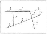
接着,详细说明导航装置1中的道路颜色变更处理及探测信息发送限制处理。在道路颜色变更处理中,由收发机接收到从VICS中心3发送来的收集状况信息后,控制装置26基于该收集状况信息而在显示装置19上显示基于上述地图数据的电子地图的情况下,进行能够在电子地图上区分未收集道路和已收集道路的控制。由此,控制装置26相当于显示控制部。Next, the road color change processing and probe information transmission restriction processing in the navigation device 1 will be described in detail. In the road color change process, when the collection status information transmitted from the
详细地说,使得与在收集状况信息中信息收集结束标志为无效的路段ID对应的路段(道路)在电子地图上的显示颜色,和与信息收集结束标志为有效的路段ID对应的路段在电子地图上的显示颜色相区分地显示。收集状况信息与图4的例相同的情况下,如图6所述,将与电子地图上的路段ID“F”对应的道路F的显示颜色和路段ID“A”~“E”、以及“G”~“I”的道路A~E、G~I的显示颜色相区分地显示。由此,导航装置1的用户能够辨别未收集道路,所以能够促使用户的车辆在未收集道路的行驶。In detail, the display color of the road section (road) corresponding to the road section ID corresponding to the invalid road section ID in the collection status information is made, and the road section corresponding to the valid road section ID with the information collection end flag is displayed on the electronic map. The display colors on the map are displayed differently. When the collection status information is the same as the example in FIG. 4, as shown in FIG. The display colors of the roads A to E and G to I of G" to "I" are displayed separately. This allows the user of the navigation device 1 to recognize the uncollected roads, so that the user's vehicle can be encouraged to travel on the uncollected roads.
另外,在本实施方式中,作为能够将未收集道路和已收集道路可区分地显示的方法,示出了使显示颜色不同的例,但是不限于此。只要是能够将未收集道路和已收集道路区分的方法,例如使未收集道路的区域闪烁显示等,也可以使用其他方法。In addition, in the present embodiment, an example of different display colors was shown as a method capable of distinguishably displaying uncollected roads and collected roads, but the present invention is not limited thereto. Other methods may be used as long as it is a method capable of distinguishing uncollected roads from collected roads, for example, displaying an area of uncollected roads by blinking.
在探测信息发送限制处理中,基于从VICS中心3发送来的收集状况信息,不向VICS中心3发送已收集了统计处理需要量的探测信息的道路的探测信息。详细地说,控制装置26进行控制,以不从收发机25发送与在收集状况信息中信息收集结束标志为有效的路段ID对应的路段(道路)的探测信息,能够只发送与信息收集结束标志为无效的路段ID对应的路段的探测信息。In the probe information transmission restriction process, based on the collection status information transmitted from the
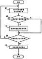
在此,使用图7说明与导航装置1中的探测信息发送限制处理相关联的处理的流程。图7是表示与导航装置1中的探测信息发送限制处理相关联的处理的流程的一例的流程图。图7所示的流程在开始某一路段的行驶时开始。Here, the flow of processing related to the probe information transmission restriction processing in the navigation device 1 will be described using FIG. 7 . FIG. 7 is a flowchart showing an example of a flow of processing related to probe information transmission restriction processing in the navigation device 1 . The flow shown in FIG. 7 starts when the travel of a certain link starts.
首先,在步骤S11中,判定对象路段的行驶是否已结束。可以采用如下的结构:基于由位置检测器11检测到的车辆的当前位置,在当前位置移动到对象路段的下一路段时,判定为路段的行驶已结束。并且,判定为路段的行驶已结束的情况下(步骤S11:是),转移到步骤S12。此外,在未判定为路段的行驶已结束的情况下(步骤S11:否),重复步骤S11的流程。First, in step S11, it is determined whether or not the travel of the target link has ended. A configuration may be adopted in which, based on the current position of the vehicle detected by the
在步骤S12中,进行已收集道路符合判别处理,转移到步骤S13。在已收集道路符合判别处理中,判定对象路段是否是与在从VICS中心3接收到的收集状况信息中信息收集结束标志为有效的路段ID对应的路段。详细地说,在收集状况信息中,根据与对象路段的路段ID对应的信息收集结束标志是否有效来判别。In step S12, the collected road conformity determination process is performed, and the process proceeds to step S13. In the collected road matching judging process, it is determined whether or not the target link is a link corresponding to a link ID whose information collection end flag is valid in the collection status information received from the
然后,在步骤S13中,在与对象路段的路段ID对应的信息收集结束标志为有效的情况下(步骤S13:是),不从收发机25发送对象路段的探测信息,结束流程。此外,与对象路段的路段ID对应的信息收集结束标志不是有效的情况下(步骤S13:否),转移到步骤S14。在步骤S14中,从收发机向VICS中心3发送对象路段的探测信息,结束流程。Then, in step S13, when the information collection end flag corresponding to the link ID of the target link is valid (step S13: Yes), the probe information of the target link is not transmitted from the
根据以上结构,不从导航装置1向VICS中心3发送已收集了统计处理需要量的探测信息的道路的探测信息,所以不花费对导航装置1及VICS中心3的双方来说多余的通信成本。因此,能够抑制探测信息的收集中的多余的通信成本。According to the above configuration, since the navigation device 1 does not send the probe information of the road for which the probe information required for statistical processing has been collected to the
另外,在上述的实施方式中,示出了如下结构:基于从VICS中心3发送来的收集状况信息,在导航装置1侧判别已收集道路,不向VICS中心3发送已收集道路的探测信息,但是不限于此。例如,也可以采用如下的结构:向导航装置1发送不从VICS中心3侧发送已收集道路的探测信息的指示(以下称为发送限制指示),在导航装置1侧,按照发送限制指示,不进行已收集道路的探测信息的发送。In addition, in the above-mentioned embodiment, the following structure was shown: Based on the collection status information transmitted from the
这种情况下,可以采用从VICS中心3的发送部38发送用于识别已收集道路的信息(例如路段ID)和发送限制指示的结构。此外,导航装置1的控制装置26按照从VICS中心3接收的路段ID及发送限制指示,使收发机不进行已收集道路的探测信息的发送。此外,也可以通过将不发送已收集道路的探测信息的期间的信息包含在发送限制指示中,在一定期间(例如1天等)不进行已收集道路的探测信息的发送。进而,也可以是,在需要探测信息的提供的情况下,从VICS中心3向导航装置1发送取消发送限制指示的指示,从而能够提供探测信息。In this case, a configuration may be adopted in which information for identifying collected roads (for example, link ID) and a transmission restriction instruction are transmitted from the
此外,在上述实施方式中,示出了在导航装置1中应用车载终端的结构,但是不限于此。只要是能够取得行驶信息和位置信息,并且能够与通信机连接的车载器,也可以在导航装置1以外的车载器中应用车载终端。In addition, in the above-mentioned embodiment, the configuration in which the vehicle-mounted terminal is applied to the navigation device 1 was shown, but it is not limited thereto. The in-vehicle terminal may be applied to in-vehicle devices other than the navigation device 1 as long as it is an in-vehicle device that can acquire travel information and position information and can be connected to a communication device.
进而,在上述的实施方式中,示出了在构成VICS中心3的服务器中应用探测信息管理装置的结构,但是不限于此。例如,也可以在构成发布VICS中心以外的道路交通信息的中心的服务器中应用探测信息管理装置。Furthermore, in the above-mentioned embodiment, the configuration in which the probe information management device is applied to the server constituting the
另外,本发明不限于上述的各实施方式,在权利要求所示的范围内可以进行各种变更,将不同的实施方式中分别公开的技术手段适当组合而得到的实施方式也包含在本发明的技术范围内。In addition, the present invention is not limited to the above-mentioned embodiments, and various changes can be made within the scope shown in the claims. Embodiments obtained by appropriately combining technical means disclosed in different embodiments are also included in the scope of the present invention. within the technical range.
Claims (8)
Applications Claiming Priority (2)
| Application Number | Priority Date | Filing Date | Title |
|---|---|---|---|
| JP029999/2011 | 2011-02-15 | ||
| JP2011029999AJP2012168796A (en) | 2011-02-15 | 2011-02-15 | Probe information management system, on-vehicle terminal, and probe information management apparatus |
Publications (1)
| Publication Number | Publication Date |
|---|---|
| CN102646333Atrue CN102646333A (en) | 2012-08-22 |
Family
ID=46659144
Family Applications (1)
| Application Number | Title | Priority Date | Filing Date |
|---|---|---|---|
| CN201210033937XAPendingCN102646333A (en) | 2011-02-15 | 2012-02-15 | Detection information management system, vehicle terminal, and detection information management device |
Country Status (2)
| Country | Link |
|---|---|
| JP (1) | JP2012168796A (en) |
| CN (1) | CN102646333A (en) |
Cited By (2)
| Publication number | Priority date | Publication date | Assignee | Title |
|---|---|---|---|---|
| CN112602134A (en)* | 2018-08-31 | 2021-04-02 | 株式会社电装 | Map generation device and map generation method |
| CN114096804A (en)* | 2019-06-13 | 2022-02-25 | 株式会社电装 | Map data generation system, data center, and in-vehicle device |
Families Citing this family (12)
| Publication number | Priority date | Publication date | Assignee | Title |
|---|---|---|---|---|
| JP6171479B2 (en)* | 2013-03-28 | 2017-08-02 | 日産自動車株式会社 | Travel data acquisition device |
| JP2015007923A (en)* | 2013-06-25 | 2015-01-15 | アイシン・エィ・ダブリュ株式会社 | Road information communication system, road information communication method, and road information communication program |
| JP6293458B2 (en)* | 2013-11-15 | 2018-03-14 | 株式会社日立製作所 | Probe information management apparatus, probe information management system, and probe information management method |
| JP6640769B2 (en)* | 2017-02-22 | 2020-02-05 | 株式会社日立製作所 | Information processing equipment, mobility data collection system |
| JP6769381B2 (en)* | 2017-04-05 | 2020-10-14 | トヨタ自動車株式会社 | Vehicle data collection system |
| JP6946802B2 (en)* | 2017-07-17 | 2021-10-06 | 株式会社デンソー | Vehicle information collection system |
| KR102727108B1 (en)* | 2018-09-14 | 2024-11-06 | 현대자동차주식회사 | Traffic guidance system and method |
| JP7040376B2 (en)* | 2018-09-19 | 2022-03-23 | トヨタ自動車株式会社 | Data collection system and vehicle |
| JP7305414B2 (en)* | 2019-04-16 | 2023-07-10 | アルパイン株式会社 | Map data update system, traveling probe information collecting device, traveling probe information providing device, and traveling probe information collecting method |
| JP7167856B2 (en)* | 2019-05-29 | 2022-11-09 | トヨタ自動車株式会社 | Data collection system and data collection method |
| JP7430272B2 (en)* | 2020-09-17 | 2024-02-09 | 本田技研工業株式会社 | Road surface evaluation device and road surface evaluation method |
| WO2022208769A1 (en)* | 2021-03-31 | 2022-10-06 | 本田技研工業株式会社 | Location information output method, location information output system, and program |
Citations (6)
| Publication number | Priority date | Publication date | Assignee | Title |
|---|---|---|---|---|
| JP2000028371A (en)* | 1998-07-08 | 2000-01-28 | Aqueous Reserch:Kk | Communication type navigation system |
| US20020128770A1 (en)* | 2001-03-09 | 2002-09-12 | Mitsubishi Denki Kabushiki Kaisha | Navigation system for transmitting real-time information allowing instant judgment of next action |
| CN1848191A (en)* | 2005-04-14 | 2006-10-18 | 株式会社日立制作所 | Traffic information collection device and vehicle-mounted device |
| CN1932446A (en)* | 2005-09-13 | 2007-03-21 | 株式会社日立制作所 | In-vehicle terminal, server, traffic information system, link data update method, and traffic information provision method |
| CN101286266A (en)* | 2008-05-14 | 2008-10-15 | 西安交通大学 | A traffic road condition information processing method based on vehicle wireless sensor network |
| CN101533561A (en)* | 2008-03-12 | 2009-09-16 | 株式会社查纳位资讯情报 | Traffic information management server, navigation terminal and method thereof |
Family Cites Families (6)
| Publication number | Priority date | Publication date | Assignee | Title |
|---|---|---|---|---|
| JPH0916892A (en)* | 1995-06-27 | 1997-01-17 | Fujitsu Ten Ltd | Navigation device |
| JP4387555B2 (en)* | 2000-05-02 | 2009-12-16 | 日本信号株式会社 | Traffic information system and information system |
| JP4506428B2 (en)* | 2004-11-22 | 2010-07-21 | 日本電気株式会社 | Probe data collection system, probe data collection method, etc. |
| JP4950590B2 (en)* | 2006-08-07 | 2012-06-13 | クラリオン株式会社 | Traffic information providing apparatus, traffic information providing system, traffic information transmission method, and traffic information request method |
| JP2008077143A (en)* | 2006-09-19 | 2008-04-03 | Kddi Corp | Probe information collecting apparatus, probe information transmitting apparatus, and probe information collecting method |
| JP5015756B2 (en)* | 2007-12-26 | 2012-08-29 | トヨタ自動車株式会社 | Traffic information distribution system, probe information generation apparatus and traffic information distribution apparatus constituting the system |
- 2011
- 2011-02-15JPJP2011029999Apatent/JP2012168796A/enactivePending
- 2012
- 2012-02-15CNCN201210033937XApatent/CN102646333A/enactivePending
Patent Citations (6)
| Publication number | Priority date | Publication date | Assignee | Title |
|---|---|---|---|---|
| JP2000028371A (en)* | 1998-07-08 | 2000-01-28 | Aqueous Reserch:Kk | Communication type navigation system |
| US20020128770A1 (en)* | 2001-03-09 | 2002-09-12 | Mitsubishi Denki Kabushiki Kaisha | Navigation system for transmitting real-time information allowing instant judgment of next action |
| CN1848191A (en)* | 2005-04-14 | 2006-10-18 | 株式会社日立制作所 | Traffic information collection device and vehicle-mounted device |
| CN1932446A (en)* | 2005-09-13 | 2007-03-21 | 株式会社日立制作所 | In-vehicle terminal, server, traffic information system, link data update method, and traffic information provision method |
| CN101533561A (en)* | 2008-03-12 | 2009-09-16 | 株式会社查纳位资讯情报 | Traffic information management server, navigation terminal and method thereof |
| CN101286266A (en)* | 2008-05-14 | 2008-10-15 | 西安交通大学 | A traffic road condition information processing method based on vehicle wireless sensor network |
Cited By (3)
| Publication number | Priority date | Publication date | Assignee | Title |
|---|---|---|---|---|
| CN112602134A (en)* | 2018-08-31 | 2021-04-02 | 株式会社电装 | Map generation device and map generation method |
| CN112602134B (en)* | 2018-08-31 | 2022-08-30 | 株式会社电装 | Map generation device and map generation method |
| CN114096804A (en)* | 2019-06-13 | 2022-02-25 | 株式会社电装 | Map data generation system, data center, and in-vehicle device |
Also Published As
| Publication number | Publication date |
|---|---|
| JP2012168796A (en) | 2012-09-06 |
Similar Documents
| Publication | Publication Date | Title |
|---|---|---|
| CN102646333A (en) | Detection information management system, vehicle terminal, and detection information management device | |
| US8874373B2 (en) | Map information delivery system, method, and program | |
| EP2142887B1 (en) | Selecting route according to traffic information | |
| EP2377111B1 (en) | Navigation device, probe information transmission method, computer-readable storage medium that storing probe information transmission program, and traffic information generation device | |
| EP1804223B1 (en) | A travel link identification system | |
| EP1566665A1 (en) | Apparatus and method for providing ambient parameter data and for determining weather information | |
| JP4811063B2 (en) | Traffic data calculation system | |
| US20100228471A1 (en) | Navigation system and route search method | |
| JP2019153128A (en) | Traveling data collection system, traveling data collection center, and on-vehicle terminal | |
| US9374803B2 (en) | Message notification system, message transmitting and receiving apparatus, program, and recording medium | |
| JP5966675B2 (en) | Probe information collection system | |
| JP4563354B2 (en) | Map information distribution system and map information distribution method | |
| JP2010197211A (en) | Server apparatus, navigation apparatus, route information presentation system and route information presentation method | |
| JP4582401B2 (en) | Traffic jam information provision system | |
| JP6037817B2 (en) | Portable navigation device and navigation method | |
| JP2011209125A (en) | Car navigation system | |
| JP4468763B2 (en) | Automotive electronic devices | |
| JP2009116579A (en) | Vehicle information communication device, navigation device, information distribution system, information distribution server | |
| JP2007218923A (en) | Method for searching route in navigation apparatus | |
| JP5142044B2 (en) | Vehicle information communication system and vehicle information communication method | |
| JP5425953B2 (en) | Map information distribution system | |
| JP2007218924A (en) | Method for searching route in navigation apparatus | |
| US8427339B2 (en) | Information provision system and in-vehicle apparatus | |
| JP6516793B2 (en) | Route Information Providing Server, Route Guidance System, and Route Information Providing Method | |
| JP3864733B2 (en) | Navigation system, information center and in-vehicle device |
Legal Events
| Date | Code | Title | Description |
|---|---|---|---|
| C06 | Publication | ||
| PB01 | Publication | ||
| C10 | Entry into substantive examination | ||
| SE01 | Entry into force of request for substantive examination | ||
| C02 | Deemed withdrawal of patent application after publication (patent law 2001) | ||
| WD01 | Invention patent application deemed withdrawn after publication | Application publication date:20120822 |