CN102607566A - Road live-action navigation system and method - Google Patents
Road live-action navigation system and methodDownload PDFInfo
- Publication number
- CN102607566A CN102607566ACN2011100275547ACN201110027554ACN102607566ACN 102607566 ACN102607566 ACN 102607566ACN 2011100275547 ACN2011100275547 ACN 2011100275547ACN 201110027554 ACN201110027554 ACN 201110027554ACN 102607566 ACN102607566 ACN 102607566A
- Authority
- CN
- China
- Prior art keywords
- road
- degree
- streetscape
- date
- electric device
- Prior art date
- Legal status (The legal status is an assumption and is not a legal conclusion. Google has not performed a legal analysis and makes no representation as to the accuracy of the status listed.)
- Pending
Links
Images


Landscapes
- Navigation (AREA)
Abstract
Description
Translated fromChinese技术领域technical field
本发明涉及一种道路导航系统及方法,特别是关于一种道路实景导航系统及方法。The invention relates to a road navigation system and method, in particular to a road real scene navigation system and method.
背景技术Background technique
传统的道路导航系统未与实地拍摄的360度街景相结合,仅能以电子地图或虚拟场景方式进行导航作业。若现场道路标示被遮蔽,或因道路施工、天色差异等因素,都会造成驾驶人不易以直觉方式确认电子地图或虚拟场景所指示的路线位置。当驾驶人使用传统道路导航系统行驶至匝道路口、高架桥或平面道路交错纵横的路段时,也不易判别传统道路导航系统中电子地图或虚拟场景所标示的路线为何种道路,亦容易因此而发生错上高架桥,或行驶于错误的道路等状况发生,造成驾驶人使用传统道路导航系统进行行车导航上的不便。The traditional road navigation system is not combined with the 360-degree street view shot on the spot, and can only conduct navigation operations in the form of electronic maps or virtual scenes. If the on-site road signs are obscured, or due to factors such as road construction and weather differences, it will be difficult for drivers to intuitively confirm the route position indicated by the electronic map or virtual scene. When the driver uses the traditional road navigation system to drive to the intersection of ramps, viaducts or flat roads, it is not easy to judge the route marked by the electronic map or virtual scene in the traditional road navigation system, and it is easy to make mistakes. Going on viaducts, or driving on wrong roads, etc., will cause inconvenience for drivers to use traditional road navigation systems for driving navigation.
发明内容Contents of the invention
鉴于以上内容,有必要提供一种道路实景导航系统及方法,能够在放置在车辆前的手持式电子装置中播放与驾驶人当前行驶道路具有相同街景的全方位道路实景影像画面,方便驾驶人驾驶车辆。In view of the above, it is necessary to provide a road real scene navigation system and method, which can play a full range of road real scene video images with the same street view as the driver's current driving road in the hand-held electronic device placed in front of the vehicle, so as to facilitate the driver's driving. vehicle.
所述的道路实景导航系统安装并运行于手持式电子装置中。该手持式电子装置通过无线网络与后端主机建立通信连接。该手持式电子装置包括GPS、电子罗盘以及显示屏幕。该道路实景导航系统包括:路线规划模块,用于在显示屏幕上显示用户操作界面,接收驾驶人在该用户操作界面上设置的行车路线信息,根据行车路线信息在电子地图上进行位置标定来规划行车路线,以及根据规划的行车路线分析道路实景导航信息;道路导航模块,用于通过持续侦测手持式电子装置所处位置的经度与纬度坐标来识别车辆的当前位置,以及通过电子罗盘侦测手持式电子装置的指示方向来识别车辆的前进方向,从手持式电子装置中获取当前时间及日期,以及将车辆的当前位置、前进方向、当前时间及日期相关信息通过无线网络发送至后端主机;影像获取模块,用于通过无线网络从后端主机的存储装置中获取与当前位置、前进方向、当前时间及日期相关信息所对应的360度街景影像画面,以及将该360度街景影像画面在显示屏幕上进行播放。The road real scene navigation system is installed and operated in the hand-held electronic device. The handheld electronic device establishes a communication connection with the backend host through the wireless network. The handheld electronic device includes GPS, electronic compass and display screen. The road real scene navigation system includes: a route planning module, which is used to display the user operation interface on the display screen, receive the driving route information set by the driver on the user operation interface, and perform position calibration on the electronic map according to the driving route information to plan Driving route, and analyze road real-world navigation information according to the planned driving route; road navigation module, used to identify the current position of the vehicle through continuous detection of the longitude and latitude coordinates of the position of the handheld electronic device, and through electronic compass detection The hand-held electronic device indicates the direction to identify the direction of the vehicle, obtains the current time and date from the hand-held electronic device, and sends the vehicle's current position, direction of travel, current time and date related information to the back-end host through the wireless network The image acquisition module is used to obtain the 360-degree street view image frame corresponding to the current position, the heading direction, the current time and date related information from the storage device of the back-end host through the wireless network, and the 360-degree street view image frame in the Play on the display screen.
所述的道路实景导航方法包括步骤:预先实地拍摄道路的360度街景影像画面,并在电子地图上针对所摄得360度街景影像画面进行位置标定;将电子地图及其相对应位置的360度街景影像画面存储于后端主机的存储装置中;在显示屏幕上显示用户操作界面,并接收驾驶人在该用户操作界面上设置的行车路线信息;根据行车路线信息在电子地图上进行位置标定来规划行车路线,并根据规划的行车路线分析道路实景导航信息;通过持续侦测手持式电子装置所处位置的经度与纬度坐标来识别车辆的当前位置;通过电子罗盘侦测手持式电子装置的指示方向来识别车辆的前进方向;从手持式电子装置中获取当前时间及日期,并将车辆的当前位置、前进方向、当前时间及日期相关信息通过无线网络发送至后端主机;通过无线网络从后端主机的存储装置中获取与当前位置、前进方向、当前时间及日期相关信息所对应的360度街景影像画面;以及将该360度街景影像画面在显示屏幕上进行播放。The road real-scene navigation method includes the steps of: taking a 360-degree street view image frame of the road in advance, and performing position calibration on the electronic map for the captured 360-degree street view image frame; The street view image is stored in the storage device of the back-end host; the user interface is displayed on the display screen, and the driving route information set by the driver on the user operation interface is received; the location is calibrated on the electronic map according to the driving route information. Plan the driving route, and analyze the real road navigation information according to the planned driving route; identify the current position of the vehicle by continuously detecting the longitude and latitude coordinates of the position of the handheld electronic device; detect the indication of the handheld electronic device through the electronic compass direction to identify the direction of the vehicle; obtain the current time and date from the handheld electronic device, and send the vehicle's current position, direction, current time and date related information to the back-end host through the wireless network; Acquiring the 360-degree street view video frame corresponding to the current location, heading direction, current time and date related information from the storage device of the end host; and playing the 360-degree street view video frame on the display screen.
相较于现有技术,本发明所述的道路实景导航系统及方法能够根据驾驶人所输入的路线数据进行行车路线规划与道路实景导航作业,且可按当前时间与日期相关信息显示驾驶人的当前位置距离当前日期最近、且符合该时间点的360度街景影像画面,从而方便驾驶人驾驶车辆。Compared with the prior art, the road real-scene navigation system and method described in the present invention can perform driving route planning and road real-scene navigation operations according to the route data input by the driver, and can display the driver's current time and date related information. The current location is the closest to the current date and matches the 360-degree street view image of the time point, so that it is convenient for the driver to drive the vehicle.
附图说明Description of drawings
图1是本发明道路实景导航系统较佳实施例的架构图。Fig. 1 is a structure diagram of a preferred embodiment of the real road navigation system of the present invention.
图2是各时间点所对应各日期的360度街景影像画面的示意图。FIG. 2 is a schematic diagram of the 360-degree street view images of each date corresponding to each time point.
图3是本发明道路实景导航方法较佳实施例的流程图。Fig. 3 is a flow chart of a preferred embodiment of the road real scene navigation method of the present invention.
图4是在用户操作界面中设置行车路线信息的示意图。Fig. 4 is a schematic diagram of setting driving route information in the user operation interface.
图5是在用户操作界面中选择道路实景导航模式的示意图。Fig. 5 is a schematic diagram of selecting a road real scene navigation mode in the user operation interface.
图6是在显示屏幕上播放360度街景影像画面的示意图。FIG. 6 is a schematic diagram of playing a 360-degree street view image on a display screen.
主要元件符号说明Description of main component symbols
手持式电子装置 1Handheld
道路实景导航系统 10Real
路线规划模块 101Route Planning Module 101
道路导航模块 102
影像获取模块 103
GPS 11
电子罗盘 12
显示屏幕 13
存储单元 14
微处理器 15
后端主机 2
网络传输单元 21
存储装置 22
无线网络 3Wireless Network 3
具体实施方式Detailed ways
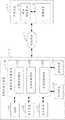
如图1所示,是本发明道路实景导航系统10较佳实施例的架构图。在本实施例中,所述的道路实景导航系统10安装并运行于手持式电子装置1中,能够根据驾驶人输入的路线信息进行行车路线规划与道路实景导航,且可按当前时间与日期相关信息显示驾驶人的当前位置距离当前日期最近、且符合该时间点的360度街景影像画面数据,方便驾驶人驾驶车辆。该手持式电子装置1放置于车辆的前方位置,并通过无线网络3与后端主机2建立通信连接。所述的360度街景影像画面是指与驾驶人当前行驶道路具有相同街景、相同日照角度等状况的全方位道路实景影像画面。As shown in FIG. 1 , it is a structure diagram of a preferred embodiment of a real
所述的手持式电子装置1可以是手机、行动电话、PDA以及笔记本计算机之一种。在本实施例中,该手持式电子装置1包括,但不仅限于,全球定位系统(Global Position System,GPS)11、电子罗盘12、显示屏幕13、存储单元14以及微处理器15。The handheld
所述的GPS 11用于持续针对手持式电子装置1所处位置的经度与纬度坐标进行侦测,以确认驾驶人的当前位置。所述的电子罗盘12用于持续针对手持式电子装置1的指示方向进行侦测,以确认手持式电子装置1所在车辆的前进方向。所述的显示屏幕13是一种具有手写功能的触控式屏幕,驾驶人可通过手写笔或手指触控方式输入车辆的行车路线数据,例如行车路线的起点及终点的相关信息,用于显示当前行驶道路的360度街景影像画面。The
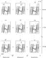
所述的后端主机2可以安置在道路监控中心或其它道路控制区域,以便系统管理人员对后端主机2进行维护。该后端主机2可以是服务器或者工作站计算机,其包括,但不仅限于,网络传输单元21以及存储装置22。所述的网络传输单元21用于通过无线网络3接收手持式电子装置1发送的行车路线数据,以及将驾驶人的当前行车路线的360度街景影像画面数据发送至手持式电子装置1。所述的存储装置22用于存储电子地图以及实地拍摄的各时间点、日期所对应的360度街景影像画面。参考图2,影像a1、a2、...、an是每一天上午9:00所对应的360度街景影像画面,影像b1、b2、...、bn是每一天下午17:00所对应的360度街景影像画面,以及影像c1、c2、...、cn是每一天晚上20:00所对应的360度街景影像画面。The back-
在使用本发明所述的道路实景导航系统10前,系统管理人员需预先制作实地拍摄的360度街景影像画面,并定期进行各时间点、不同日期的360度街景影像拍摄作业,例如每三天,即针对各时段(例如以1~2小时为一单位)进行360度街景影像拍摄,以便持续更新市区街景各时间点、日期的360度街景影像画面,再将摄得的360度街景影像画面相对在电子地图上的位置进行标定。通过后端主机2的网络传输单元21将持续更新的360度街景影像画面与相关设定信息存放在后端主机2的存储装置22中,以供道路实景导航系统10使用。在其它实施例中,所述的电子地图与360度街景影像画面也可以通过网络服务提供方(例如Google Map或者Google Street View)下载并更新市区街景各时间点、日期的360度街景影像画面。Before using the road real
在本实施例中,所述的道路实景导航系统10包括路线规划模块101、道路导航模块102以及影像获取模块103。本发明所称的模块是指一种能够被手持式电子装置1的微处理器15所执行并且能够完成固定功能的一系列计算机程序段,其存储从手持式电子装置1的存储单元14中。In this embodiment, the real
所述的路线规划模块101用于当驾驶人开启安装在手持式电子装置1内的道路实景导航系统10时,在显示屏幕13上显示该道路实景导航系统10的用户操作界面,并接收驾驶人在该用户操作界面中设置的行车路线信息,例如起点与终点位置。参考图4所示,驾驶人可以在显示在屏幕13上的用户操作界面中设置起点与终点位置的行车路线信息,例如起点为深圳市,终点为广州市。The route planning module 101 is used for displaying the user interface of the real-
所述的路线规划模块101还用于根据所述行车路线信息在电子地图上进行标定来规划行车路线,并根据规划的行车路线分析道路实景导航信息。在本实施例中,路线规划模块101根据驾驶人输入的行车路线信息进行路线规划与道路实景导航等信息分析作业,待驾驶人确认规划路线后即以驾驶人确认的行车路线信息进行道路实景导航。The route planning module 101 is also used for marking on the electronic map according to the driving route information to plan the driving route, and analyzing the real road navigation information according to the planned driving route. In this embodiment, the route planning module 101 performs information analysis operations such as route planning and road real-scene navigation based on the driving route information input by the driver, and performs road real-scene navigation based on the driving route information confirmed by the driver after the driver confirms the planned route .
所述的道路导航模块102用于通过GPS 11持续侦测手持式电子装置1所处位置的经度与纬度坐标来识别车辆的当前位置,以及通过电子罗盘12侦测手持式电子装置1的指示方向来识别车辆的前进方向。该道路导航模块102还用于从手持式电子装置1中获取当前时间及日期,以及将车辆的当前位置、前进方向、当前时间及日期相关信息通过无线网络3发送至后端主机2。The
所述的影像获取模块103用于通过无线网络3从后端主机2的存储装置22中获取与当前位置、前进方向、当前时间及日期相关信息对应的360度街景影像画面,并将该影像画面从手持式电子装置1的显示屏幕13上进行播放。在本实施例中,当后端主机2接收到车辆的当前位置、前进方向相关信息后,将根据当前时间与日期从存储装置22中查找距离当前日期最近、且符合当前时间点的360度街景数据,并从该360度街景资料中取得与车辆的当前位置、前进方向相对应的360度街景影像画面。The
如图3所示,是本发明道路实景导航方法较佳实施例的流程图。在本实施例中,该方法能够根据驾驶人输入的路线数据进行行车路线规划与道路实景导航作业,且可按当前时间与日期相关信息显示驾驶人的当前位置距离当前日期最近、且符合该时间点的360度街景影像画面,以方便驾驶人驾驶车辆。As shown in FIG. 3 , it is a flow chart of a preferred embodiment of the road real scene navigation method of the present invention. In this embodiment, the method can perform driving route planning and road real-world navigation based on the route data input by the driver, and can display the driver's current position closest to the current date according to the current time and date-related information, and conforms to the time The 360-degree street view image screen of the point is convenient for the driver to drive the vehicle.
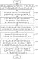
步骤S31,系统管理人员预先实地拍摄360度街景影像画面,并在电子地图上针对所摄得360度街景影像画面进行位置标定。在本实施例中,系统管理人员预先制作实地拍摄360度街景影像画面,并定期进行各时间点、不同日期的360度街景影像拍摄作业,例如每三天,即针对各时段(例如以1~2小时为一单位)进行360度街景影像拍摄,以便持续更新市区街景各时间点、日期的360度街景影像画面,再将摄得360度街景影像画面相对在电子地图上的位置进行标定。In step S31 , the system manager takes a 360-degree street view image on the spot in advance, and calibrates the position of the captured 360-degree street view image on the electronic map. In this embodiment, the system administrators pre-made on-the-spot 360-degree street view image images, and regularly carried out 360-degree street view image shooting operations at different time points and on different days, for example, every three days, for each time period (for example, 1~ 2 hours as a unit) to shoot 360-degree street view images in order to continuously update the 360-degree street view images of urban street views at various time points and dates, and then calibrate the captured 360-degree street view images relative to their positions on the electronic map.
步骤S32,后端主机2的网络传输单元21将电子地图及其相对应位置的360度街景影像画面存储于后端主机的存储装置22中。在本实施例中,系统管理人员通过网络传输单元21将持续更新的360度街景影像画面与相关设定信息存放于后端主机2的存储装置22中,以供道路实景导航系统10使用。在其它实施例中,所述的电子地图与360度街景影像画面也可以通过网络服务提供方(例如Google Map或者Google Street View)下载并更新市区街景各时间点、日期的360度街景影像画面。Step S32 , the
步骤S33,当驾驶人开启安装从手持式电子装置1内的道路实景导航系统10时,路线规划模块101在显示屏幕13上显示该道路实景导航系统10的用户操作界面,并接收驾驶人在该用户操作界面中设置的行车路线信息,例如起点与终点位置。参考图4所示,驾驶人可以在显示在屏幕13上的用户操作界面中设置起点与终点位置的行车路线信息,例如起点为深圳市,终点为广州市。Step S33, when the driver turns on the real-world
步骤S34,路线规划模块101根据所述行车路线信息在电子地图上进行标定来规划行车路线,并根据规划的行车路线分析道路实景导航信息。在本实施例中,路线规划模块101根据驾驶人输入的行车路线信息进行路线规划与道路实景导航等信息分析,待驾驶人确认规划路线后即以驾驶人确认的行车路线信息进行道路实景导航。Step S34 , the route planning module 101 plans a driving route by marking on the electronic map according to the driving route information, and analyzes the road real scene navigation information according to the planned driving route. In this embodiment, the route planning module 101 performs route planning and road real-scene navigation information analysis according to the driving route information input by the driver, and performs road real-scene navigation based on the driving route information confirmed by the driver after the driver confirms the planned route.
步骤S35,道路导航模块102通过GPS 11持续侦测手持式电子装置1所处位置的经度与纬度坐标来识别车辆的当前位置,并通过电子罗盘12侦测手持式电子装置1的指示方向来识别车辆的前进方向。Step S35, the
步骤S36,道路导航模块102从手持式电子装置1中获取当前时间及日期,并将车辆的当前位置、前进方向、当前时间及日期等相关信息通过无线网络3发送至后端主机2。Step S36 , the
步骤S37,影像获取模块103通过无线网络3从后端主机2的存储装置22中获取与当前位置、前进方向、当前时间及日期相关信息对应的360度街景影像画面,并将该影像画面从手持式电子装置1的显示屏幕13上进行播放。在本实施例中,当后端主机2接收到车辆的当前位置、前进方向相关信息后,将根据当前时间与日期从存储装置22中查找距离当前日期最近、且符合当前时间点的360度街景数据,并由该360度街景资料中取得与车辆的当前位置、前进方向相对应的360度街景影像画面。Step S37, the
在本实施例中,驾驶人可在显示屏幕13的用户操作界面中选择导航模式,其包括预设导航模式以及自订导航模式。参考图5所示,当驾驶人选择预设导航模式时,影像获取模块103将距离当前日期最近且符合该时间点的360度街景影像画面播放在显示屏幕13上。当驾驶人选择自订导航模式时,驾驶人可以自行选取任何日期符合该时间点的360度街景像画面在显示屏幕13上进行播放。In this embodiment, the driver can select a navigation mode on the user interface of the
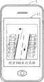
参考图6所示,当手持式电子装置1接收到后端主机2传送的360度街景影像画面后,影像获取模块103将360度街景影像画面与道路相关导航信息(例如图6所示的前方100米向左转等导航信息)一并在显示屏幕13上进行播放。当驾驶人选择自订导航模式时,能够根据随着当前位置、使用时间等状况主动调整360度街景影像画面,从而使驾驶人不论何时都可以看到当时与道路状况相仿的360度街景影像画面,让驾驶人能够更直觉地掌握导航信息到达行车终点目的地。Referring to FIG. 6, after the handheld
以上实施例仅用以说明本发明的技术方案而非限制,尽管参照以上较佳实施例对本发明进行了详细说明,本领域的普通技术人员应当理解,可以对本发明的技术方案进行修改或等同替换都不应脱离本发明技术方案的精神和范围。The above embodiments are only used to illustrate the technical solutions of the present invention without limitation. Although the present invention has been described in detail with reference to the above preferred embodiments, those of ordinary skill in the art should understand that the technical solutions of the present invention can be modified or equivalently replaced All should not deviate from the spirit and scope of the technical solution of the present invention.
Claims (10)
Priority Applications (1)
| Application Number | Priority Date | Filing Date | Title |
|---|---|---|---|
| CN2011100275547ACN102607566A (en) | 2011-01-25 | 2011-01-25 | Road live-action navigation system and method |
Applications Claiming Priority (1)
| Application Number | Priority Date | Filing Date | Title |
|---|---|---|---|
| CN2011100275547ACN102607566A (en) | 2011-01-25 | 2011-01-25 | Road live-action navigation system and method |
Publications (1)
| Publication Number | Publication Date |
|---|---|
| CN102607566Atrue CN102607566A (en) | 2012-07-25 |
Family
ID=46525168
Family Applications (1)
| Application Number | Title | Priority Date | Filing Date |
|---|---|---|---|
| CN2011100275547APendingCN102607566A (en) | 2011-01-25 | 2011-01-25 | Road live-action navigation system and method |
Country Status (1)
| Country | Link |
|---|---|
| CN (1) | CN102607566A (en) |
Cited By (20)
| Publication number | Priority date | Publication date | Assignee | Title |
|---|---|---|---|---|
| CN103134499A (en)* | 2013-02-06 | 2013-06-05 | 腾讯科技(深圳)有限公司 | Navigation method and navigation device |
| CN103644921A (en)* | 2013-12-06 | 2014-03-19 | 北京奇虎科技有限公司 | Method and device for realizing street view display |
| CN103791912A (en)* | 2012-10-30 | 2014-05-14 | 大陆汽车投资(上海)有限公司 | Navigation path planning device supporting hand-painted path |
| CN103884342A (en)* | 2012-12-19 | 2014-06-25 | 奥迪股份公司 | Method and control device for providing a street layout ahead |
| CN104266654A (en)* | 2014-09-26 | 2015-01-07 | 广东好帮手电子科技股份有限公司 | Vehicle real scene navigation system and method |
| CN104359487A (en)* | 2014-11-13 | 2015-02-18 | 沈阳美行科技有限公司 | Real scene navigation system |
| CN104457790A (en)* | 2014-11-27 | 2015-03-25 | 百度在线网络技术(北京)有限公司 | Method for evaluating inductive effect of navigation product, testing device and construction method for testing device |
| CN104596523A (en)* | 2014-06-05 | 2015-05-06 | 腾讯科技(深圳)有限公司 | Streetscape destination guide method and streetscape destination guide equipment |
| CN104613975A (en)* | 2014-07-30 | 2015-05-13 | 腾讯科技(深圳)有限公司 | Street view display and sending method and equipment in navigation, server and system |
| CN105117455A (en)* | 2015-08-18 | 2015-12-02 | 北京奇虎科技有限公司 | Along-the-road target image search method, terminal and system |
| CN105157711A (en)* | 2015-10-14 | 2015-12-16 | 北京乐动卓越科技有限公司 | Navigation method and system for panoramic map |
| CN105466413A (en)* | 2015-11-10 | 2016-04-06 | 上海格虏博运动科技有限公司 | An augmented-reality real-scene navigation technique based on an intelligent mobile platform and combining GPS |
| CN105513389A (en)* | 2015-11-30 | 2016-04-20 | 小米科技有限责任公司 | Method and device for augmented reality |
| WO2016095176A1 (en)* | 2014-12-18 | 2016-06-23 | Nokia Technologies Oy | Interacting with a perspective view |
| CN105841712A (en)* | 2016-06-02 | 2016-08-10 | 安徽机电职业技术学院 | Unmanned tour guide vehicle |
| CN105933651A (en)* | 2016-05-04 | 2016-09-07 | 深圳市至壹科技开发有限公司 | Method and apparatus for jumper connection of video on the basis of object route |
| CN107152935A (en)* | 2017-06-05 | 2017-09-12 | 成都车之联科技服务有限责任公司 | A kind of road live-action navigation system and road live view navigation method |
| CN107389067A (en)* | 2017-07-17 | 2017-11-24 | 广州地理研究所 | Applied to the outdoor scene point switching method in navigation |
| CN108592939A (en)* | 2018-07-11 | 2018-09-28 | 维沃移动通信有限公司 | A kind of air navigation aid and terminal |
| CN109974729A (en)* | 2019-03-07 | 2019-07-05 | 百度在线网络技术(北京)有限公司 | Update method, the device and system of street view image |
Citations (7)
| Publication number | Priority date | Publication date | Assignee | Title |
|---|---|---|---|---|
| CN1367469A (en)* | 2002-03-07 | 2002-09-04 | 上海交通大学 | Shooting, formation, transmission and display method of road overall view image tape |
| CN1474934A (en)* | 2000-11-21 | 2004-02-11 | �����ɷ� | Method and device for orienting map display in mobile or portable device |
| US7013216B2 (en)* | 2002-09-18 | 2006-03-14 | Garmin Ltd. | Methods and systems to interface navigation operations |
| CN101446195A (en)* | 2008-12-22 | 2009-06-03 | 中国石油集团长城钻探工程有限公司 | Synchronous observation seismic logging method for multiple observation systems |
| US20090202102A1 (en)* | 2008-02-08 | 2009-08-13 | Hermelo Miranda | Method and system for acquisition and display of images |
| CN101719130A (en)* | 2009-11-25 | 2010-06-02 | 中兴通讯股份有限公司 | Implementation method of Street View and implementation system thereof |
| GB2470713A (en)* | 2009-04-03 | 2010-12-08 | Digiguide Ltd | Handheld navigation device presenting recorded media content associated with user selected targets |
- 2011
- 2011-01-25CNCN2011100275547Apatent/CN102607566A/enactivePending
Patent Citations (7)
| Publication number | Priority date | Publication date | Assignee | Title |
|---|---|---|---|---|
| CN1474934A (en)* | 2000-11-21 | 2004-02-11 | �����ɷ� | Method and device for orienting map display in mobile or portable device |
| CN1367469A (en)* | 2002-03-07 | 2002-09-04 | 上海交通大学 | Shooting, formation, transmission and display method of road overall view image tape |
| US7013216B2 (en)* | 2002-09-18 | 2006-03-14 | Garmin Ltd. | Methods and systems to interface navigation operations |
| US20090202102A1 (en)* | 2008-02-08 | 2009-08-13 | Hermelo Miranda | Method and system for acquisition and display of images |
| CN101446195A (en)* | 2008-12-22 | 2009-06-03 | 中国石油集团长城钻探工程有限公司 | Synchronous observation seismic logging method for multiple observation systems |
| GB2470713A (en)* | 2009-04-03 | 2010-12-08 | Digiguide Ltd | Handheld navigation device presenting recorded media content associated with user selected targets |
| CN101719130A (en)* | 2009-11-25 | 2010-06-02 | 中兴通讯股份有限公司 | Implementation method of Street View and implementation system thereof |
Cited By (27)
| Publication number | Priority date | Publication date | Assignee | Title |
|---|---|---|---|---|
| CN103791912A (en)* | 2012-10-30 | 2014-05-14 | 大陆汽车投资(上海)有限公司 | Navigation path planning device supporting hand-painted path |
| CN103884342A (en)* | 2012-12-19 | 2014-06-25 | 奥迪股份公司 | Method and control device for providing a street layout ahead |
| CN103134499A (en)* | 2013-02-06 | 2013-06-05 | 腾讯科技(深圳)有限公司 | Navigation method and navigation device |
| CN103644921A (en)* | 2013-12-06 | 2014-03-19 | 北京奇虎科技有限公司 | Method and device for realizing street view display |
| CN104596523A (en)* | 2014-06-05 | 2015-05-06 | 腾讯科技(深圳)有限公司 | Streetscape destination guide method and streetscape destination guide equipment |
| US10677609B2 (en) | 2014-06-05 | 2020-06-09 | Tencent Technology (Shenzhen) Company Limited | Method and device for providing guidance to street view destination |
| US9891073B2 (en) | 2014-06-05 | 2018-02-13 | Tencent Technology (Shenzhen) Company Limited | Method and device for providing guidance to street view destination |
| CN104613975A (en)* | 2014-07-30 | 2015-05-13 | 腾讯科技(深圳)有限公司 | Street view display and sending method and equipment in navigation, server and system |
| CN104613975B (en)* | 2014-07-30 | 2019-03-08 | 腾讯科技(深圳)有限公司 | Method and apparatus, server and the system of streetscape figure are shown and sent in navigation |
| CN104266654A (en)* | 2014-09-26 | 2015-01-07 | 广东好帮手电子科技股份有限公司 | Vehicle real scene navigation system and method |
| CN104359487A (en)* | 2014-11-13 | 2015-02-18 | 沈阳美行科技有限公司 | Real scene navigation system |
| CN104359487B (en)* | 2014-11-13 | 2017-06-23 | 沈阳美行科技有限公司 | A kind of real scene navigation system |
| CN104457790A (en)* | 2014-11-27 | 2015-03-25 | 百度在线网络技术(北京)有限公司 | Method for evaluating inductive effect of navigation product, testing device and construction method for testing device |
| CN104457790B (en)* | 2014-11-27 | 2017-07-25 | 百度在线网络技术(北京)有限公司 | Evaluate and test method, test device and its construction method of the inducing effect of navigation product |
| WO2016095176A1 (en)* | 2014-12-18 | 2016-06-23 | Nokia Technologies Oy | Interacting with a perspective view |
| CN105117455A (en)* | 2015-08-18 | 2015-12-02 | 北京奇虎科技有限公司 | Along-the-road target image search method, terminal and system |
| CN105157711A (en)* | 2015-10-14 | 2015-12-16 | 北京乐动卓越科技有限公司 | Navigation method and system for panoramic map |
| CN105466413A (en)* | 2015-11-10 | 2016-04-06 | 上海格虏博运动科技有限公司 | An augmented-reality real-scene navigation technique based on an intelligent mobile platform and combining GPS |
| CN105513389A (en)* | 2015-11-30 | 2016-04-20 | 小米科技有限责任公司 | Method and device for augmented reality |
| CN105933651A (en)* | 2016-05-04 | 2016-09-07 | 深圳市至壹科技开发有限公司 | Method and apparatus for jumper connection of video on the basis of object route |
| CN105933651B (en)* | 2016-05-04 | 2019-04-30 | 深圳市至壹科技开发有限公司 | Method and apparatus based on target route jumper connection video |
| CN105841712A (en)* | 2016-06-02 | 2016-08-10 | 安徽机电职业技术学院 | Unmanned tour guide vehicle |
| CN107152935A (en)* | 2017-06-05 | 2017-09-12 | 成都车之联科技服务有限责任公司 | A kind of road live-action navigation system and road live view navigation method |
| CN107389067A (en)* | 2017-07-17 | 2017-11-24 | 广州地理研究所 | Applied to the outdoor scene point switching method in navigation |
| CN107389067B (en)* | 2017-07-17 | 2020-08-04 | 广州地理研究所 | A Real Point Switching Method Applied in Navigation |
| CN108592939A (en)* | 2018-07-11 | 2018-09-28 | 维沃移动通信有限公司 | A kind of air navigation aid and terminal |
| CN109974729A (en)* | 2019-03-07 | 2019-07-05 | 百度在线网络技术(北京)有限公司 | Update method, the device and system of street view image |
Similar Documents
| Publication | Publication Date | Title |
|---|---|---|
| CN102607566A (en) | Road live-action navigation system and method | |
| TWI437209B (en) | Panoramic road navigation system and method | |
| NL2002099C2 (en) | Improved Navigation Device and Method. | |
| US11676307B2 (en) | Online sensor calibration for autonomous vehicles | |
| US20090177378A1 (en) | Navigation device and method | |
| CN101159068B (en) | Information collection and processing method for land inspection and real-time monitoring by field equipment | |
| EP2920954B1 (en) | Automatic image capture | |
| CN108871369B (en) | Vehicle navigation map display method, electronic device, server and storage medium | |
| CN111157009A (en) | Indoor positioning navigation creating method and system based on mobile terminal and AR (augmented reality) intelligence | |
| US20090202102A1 (en) | Method and system for acquisition and display of images | |
| US20100245561A1 (en) | Navigation device | |
| CN106971583A (en) | A kind of traffic information shared system and sharing method based on vehicle-mounted networking equipment | |
| CN103674016A (en) | Walking guide system based on mobile terminal and implementation method of walking guide system | |
| CN104359487A (en) | Real scene navigation system | |
| CN104075729A (en) | Method, device and terminal device for displaying electronic map | |
| CN104236578A (en) | Navigation method and navigation system | |
| CN1979094A (en) | Electronic device, display processing method and program | |
| CN102506853A (en) | Path planning method, navigation method, location service equipment and server | |
| CN105136160A (en) | Mobile terminal-augmented reality technology-based close range optimal bus station navigation method | |
| US7693658B2 (en) | Navigation apparatus | |
| US10267637B2 (en) | System and method for providing navigation information based on an operating mode | |
| JP2007174016A (en) | Information distribution system | |
| CN107341213A (en) | A kind of streetscape view preparation method and system | |
| CN105987700A (en) | Apparatus and method for guiding driving route using photographic image | |
| JP2013225275A (en) | Three-dimensional image display system |
Legal Events
| Date | Code | Title | Description |
|---|---|---|---|
| C06 | Publication | ||
| PB01 | Publication | ||
| C10 | Entry into substantive examination | ||
| SE01 | Entry into force of request for substantive examination | ||
| C02 | Deemed withdrawal of patent application after publication (patent law 2001) | ||
| WD01 | Invention patent application deemed withdrawn after publication | Application publication date:20120725 |