CN102291817A - Group positioning method based on location measurement sample in mobile communication network - Google Patents
Group positioning method based on location measurement sample in mobile communication networkDownload PDFInfo
- Publication number
- CN102291817A CN102291817ACN2011101926352ACN201110192635ACN102291817ACN 102291817 ACN102291817 ACN 102291817ACN 2011101926352 ACN2011101926352 ACN 2011101926352ACN 201110192635 ACN201110192635 ACN 201110192635ACN 102291817 ACN102291817 ACN 102291817A
- Authority
- CN
- China
- Prior art keywords
- terminal
- tested
- data vector
- base station
- terminals
- Prior art date
- Legal status (The legal status is an assumption and is not a legal conclusion. Google has not performed a legal analysis and makes no representation as to the accuracy of the status listed.)
- Granted
Links
Images


Landscapes
- Mobile Radio Communication Systems (AREA)
- Position Fixing By Use Of Radio Waves (AREA)
Abstract
Translated fromChinese
Description
Translated fromChinese技术领域technical field
本发明涉及一种移动通信网络中的定位技术,确切地说,涉及一种移动通信网络中利用多个移动终端的位置测量样本进行精确群定位的方法,属于移动通信技术领域。The invention relates to a positioning technology in a mobile communication network, more precisely, to a method for performing accurate group positioning by using position measurement samples of a plurality of mobile terminals in a mobile communication network, and belongs to the technical field of mobile communication.
背景技术Background technique
随着移动通信的迅速发展,移动通信系统中开展的移动定位业务也越来越受到众多用户的关注和应用。现在,常用的移动定位方法有下述三种:With the rapid development of mobile communication, the mobile positioning service carried out in the mobile communication system is also more and more concerned and applied by many users. Currently, there are three commonly used mobile positioning methods:
(1)基于时间测量,即到达时间TOA(Time Of Arrival)或到达时间差TDOA(Time Difference Of Arrival)的定位方法:通过检测无线电波从基站发射到移动终端接收的传播时间,计算出两者距离,再通过某种方法计算出移动终端的估计位置。其定位精度取决于通信系统的定时精度,且各个基站之间必须严格同步,以确保通信系统本身的定时误差不会对定位结果造成明显影响。例如,申请号为200780051228.1的中国专利申请就介绍一种在TOA或TDOA模式中采用被动定位目标的方法实施网格化(细分)定位区域所在的空间块的具体过程,再经过迭代分析,形成该网络的块集。每次迭代时,都要将相关的每个块细分成更小的相同子块,从而增大精确度来界定所属定位区域。(1) Positioning method based on time measurement, that is, time of arrival TOA (Time Of Arrival) or time difference of arrival TDOA (Time Difference Of Arrival): By detecting the propagation time of radio waves transmitted from the base station to the reception of the mobile terminal, the distance between the two is calculated , and then calculate the estimated position of the mobile terminal by a certain method. Its positioning accuracy depends on the timing accuracy of the communication system, and each base station must be strictly synchronized to ensure that the timing error of the communication system itself will not have a significant impact on the positioning results. For example, the Chinese patent application with the application number 200780051228.1 introduces a specific process of adopting a passive positioning target method in the TOA or TDOA mode to grid (subdivide) the spatial block where the positioning area is located, and then through iterative analysis to form The set of blocks for this network. At each iteration, each block in question is subdivided into smaller identical sub-blocks, thereby defining the localization area with increasing precision.
(2)基于信号到达角度AOA(Angle Of Arrival)的定位方法:先通过基站接收天线阵列检测出移动台发射电波的AOA,用于构成一条从基站到移动台的径向连线,即方位线;再利用多个基站提供的各个AOA测量数值,可以画出多条方位线,其交点就是移动台的估计位置。其优点是两个基站就能够实现定位;但是,基站要有接收天线阵列,其精度受到信道的影响较大,且在建筑物密集区域定位困难,在GSM网络中无法实现。(2) Positioning method based on the signal arrival angle AOA (Angle Of Arrival): First, the AOA of the radio wave transmitted by the mobile station is detected through the base station receiving antenna array, which is used to form a radial connection line from the base station to the mobile station, that is, the bearing line ; Using the AOA measurement values provided by multiple base stations, multiple bearing lines can be drawn, and the intersection point is the estimated position of the mobile station. The advantage is that two base stations can achieve positioning; however, the base station must have a receiving antenna array, and its accuracy is greatly affected by the channel, and it is difficult to locate in densely built areas, which cannot be realized in the GSM network.
(3)AGPS定位方法:是一种综合移动通信网络的基站信息和GPS信息对移动台进行定位的技术。该方法是:移动台利用通信网络提供的GPS辅助信息接收GPS原始信号,再对GPS原始信号进行解调获得GPS伪距信息,移动通信网络根据伪距信息和其它定位设备的辅助信息完成对GPS信息的处理,进而估算该移动台的位置。为了满足该方法的定位要求,至少要接收4颗卫星的信号,但在市区的密集高楼之间、在建筑物内部、或者只能见到少于4颗卫星的任何地区,GPS系统通常不起作用,这样就无法实行精确定位。而且,该方法要求终端具有GPS接收模块,定位成本高。(3) AGPS positioning method: it is a technology for positioning a mobile station by integrating base station information of a mobile communication network and GPS information. The method is as follows: the mobile station uses the GPS auxiliary information provided by the communication network to receive the original GPS signal, and then demodulates the original GPS signal to obtain the GPS pseudo-range information, and the mobile communication network completes the GPS positioning according to the pseudo-range information and auxiliary information of other positioning equipment. processing of the information to estimate the location of the mobile station. In order to meet the positioning requirements of this method, it is necessary to receive signals from at least 4 satellites, but in urban areas between dense high-rise buildings, inside buildings, or any area where less than 4 satellites can only be seen, the GPS system is usually not suitable. function, so precise positioning cannot be performed. Moreover, this method requires the terminal to have a GPS receiving module, and the cost of positioning is high.
上述三种传统定位方法都是针对一个特定的终端,其定位计算也只有一个终端参与。如何充分利用网络中的众多移动终端的测量数据,既能够提高定位精度,又可在通用移动通信网络下比较快捷、便利地实现多个移动终端的群定位;然而,国内外有关这方面的报道至今仍是空白。因此,这个课题也就成为业内科技人员关注的焦点。The above three traditional positioning methods are all aimed at a specific terminal, and only one terminal participates in the positioning calculation. How to make full use of the measurement data of many mobile terminals in the network can not only improve the positioning accuracy, but also quickly and conveniently realize the group positioning of multiple mobile terminals under the general mobile communication network; however, domestic and foreign reports on this aspect It is still blank. Therefore, this topic has become the focus of attention of scientific and technological personnel in the industry.
发明内容Contents of the invention
有鉴于此,本发明的目的是提供一种移动通信网络中的基于位置测量样本的群定位方法,本发明能够充分利用网络中众多终端的测量数据,提高定位精度,又能比较快捷、便利地同时解决移动通信网络下的多个移动终端的群定位。In view of this, the purpose of the present invention is to provide a group positioning method based on position measurement samples in a mobile communication network. The present invention can make full use of the measurement data of many terminals in the network, improve the positioning accuracy, and can quickly and conveniently At the same time, it solves the group positioning of multiple mobile terminals under the mobile communication network.
为了达到上述发明目的,本发明提供了一种移动通信网络中的基于位置测量样本的群定位方法,是基于网络测量进行的定位方法;其特征在于:待测移动终端先向基站发送导频信号,基站从接收信号中获得每个移动终端的信号到达时间TOA(Time Of Arrival)、信号接收功率W,并由这两个测量数据和该待测移动终端所在位置的平面坐标(x,y)组成测量数据向量(TOA,W,(x,y));各个基站根据其接收到的每个移动终端的测量数据向量结合空间位置码本和位置测量样本库的相关数据,分别计算出每个移动终端的定位位置后,再由每个基站将该定位位置信息分别发送给相应的移动终端。In order to achieve the purpose of the above invention, the present invention provides a group positioning method based on position measurement samples in a mobile communication network, which is a positioning method based on network measurement; it is characterized in that: the mobile terminal to be tested first sends a pilot signal to the base station , the base station obtains the signal arrival time TOA (Time Of Arrival) and signal received power W of each mobile terminal from the received signal, and uses these two measurement data and the plane coordinates (x, y) of the location of the mobile terminal to be measured Composition measurement data vector (TOA, W, (x, y)); Each base station calculates each After the location of the mobile terminal is located, each base station sends the location information to the corresponding mobile terminal.
本发明群定位方法的主要创新关键技术有下述四点:The main innovative key technologies of the group positioning method of the present invention have the following four points:
一是本发明提出基于聚类的空间位置码本和位置测量样本库中的终端数据向量的初始化方法,再利用实时更新的位置测量样本库中的数据向量来更新空间位置码本,采用聚类的方法可有效地适应实际通信中的小区内,通信热点的不均匀分布的现状,也充分利用了小区中各个移动终端的测量信息。One is that the present invention proposes a cluster-based initialization method for the spatial location codebook and the terminal data vector in the location measurement sample library, and then uses the real-time updated data vector in the location measurement sample library to update the spatial location codebook. The method can effectively adapt to the current situation of uneven distribution of communication hotspots in the actual communication cell, and also fully utilizes the measurement information of each mobile terminal in the cell.
二是不同于传统定位方法,本发明是一种基于和积算法的有效实现多个终端的群定位方法:本发明采用了网络中的多个移动终端的测量数据,通过相互迭代更新,充分利用网络中各个移动终端的测量信息,既能够一次定位计算就能够得到多个终端的定位估计位置,完成群定位;还明显提高了各个终端的定位精度。Second, different from the traditional positioning method, the present invention is a group positioning method based on the sum-product algorithm that effectively realizes multiple terminals: the present invention adopts the measurement data of multiple mobile terminals in the network, through mutual iterative update, fully utilizes The measurement information of each mobile terminal in the network can not only obtain the estimated position of multiple terminals in one positioning calculation, and complete group positioning; it also significantly improves the positioning accuracy of each terminal.
三是本发明提出基于欧式距离的小区空间位置码本搜索方法,有效合并了空间位置码本中的信号达到时间TOA和接收信号功率W信息,减少计算工作量。The third is that the present invention proposes a cell space location codebook search method based on Euclidean distance, which effectively combines the signal arrival time TOA and received signal power W information in the space location codebook to reduce the calculation workload.
四是当网络中待测终端的数量稀少时,本发明提出一种采用位置测量样本库中的数据向量作为虚拟终端来协助定位,从而有效协助待测终端实现定位,并保证定位精度。Fourth, when the number of terminals to be tested in the network is scarce, the present invention proposes a method of using the data vector in the position measurement sample library as a virtual terminal to assist positioning, thereby effectively assisting the terminal to be tested to achieve positioning and ensuring positioning accuracy.
总之,本发明方法的优点是:结合小区内的历史测量数据和当前多个移动终端的测量参数,采用群定位的方式,完成一次定位计算,就能够满足众多个用户的定位需求,而且,定位精度较高。再者,所需要的测量数据的获得非常容易、便利,现行的各种移动通信系统(如GSM、CDMA、3G等)都可适用,所以具有很好的推广应用前景。In a word, the advantage of the method of the present invention is: combined with the historical measurement data in the cell and the current measurement parameters of multiple mobile terminals, the method of group positioning is used to complete one positioning calculation, which can meet the positioning needs of many users, and the positioning Higher precision. Furthermore, the acquisition of the required measurement data is very easy and convenient, and various current mobile communication systems (such as GSM, CDMA, 3G, etc.) are applicable, so it has a good prospect for popularization and application.
附图说明Description of drawings
图1是本发明方法中的基站与待测终端的交互示意图。Fig. 1 is a schematic diagram of interaction between a base station and a terminal to be tested in the method of the present invention.
图2是本发明移动通信网络中的基于位置测量样本的群定位方法流程图。Fig. 2 is a flow chart of the group positioning method based on position measurement samples in the mobile communication network of the present invention.
图3是本发明方法中的初始化空间位置码本流程图。Fig. 3 is a flow chart of initializing a spatial position codebook in the method of the present invention.
图4是本发明方法中的和积算法估计待测终端位置流程图。Fig. 4 is a flow chart of the sum-product algorithm in the method of the present invention for estimating the position of the terminal to be tested.
图5是本发明和积算法估计待测终端位置原理示意图。Fig. 5 is a schematic diagram of the principle of estimating the position of the terminal under test by the sum-product algorithm of the present invention.
图6是本发明方法中的多个虚拟终端参与迭代估计的原理示意图。Fig. 6 is a schematic diagram of the principle of multiple virtual terminals participating in iterative estimation in the method of the present invention.
图7是本发明中的位置测量样本库更新示意图。Fig. 7 is a schematic diagram of updating the position measurement sample library in the present invention.
图8是本发明中的空间位置码本更新流程图。Fig. 8 is a flow chart of updating the spatial location codebook in the present invention.
图9是本发明实施例中的仿真小区划分示意图。Fig. 9 is a schematic diagram of division of simulated cells in the embodiment of the present invention.
图10是本发明实施例中的两种定位均方根误差曲线示意图。Fig. 10 is a schematic diagram of two positioning root mean square error curves in the embodiment of the present invention.
具体实施方式Detailed ways
为使本发明的目的、技术方案和优点更加清楚,下面结合附图和实施例对本发明作进一步的详细描述。In order to make the object, technical solution and advantages of the present invention clearer, the present invention will be further described in detail below in conjunction with the accompanying drawings and embodiments.
本发明是一种基于网络侧的移动通信网络中的基于位置测量样本的群定位方法:先由待测移动终端向基站发送导频信号,基站从接收到的信号得出移动终端的测量信息(例如,GSM网络中可以获得信号达到时间TOA(Time OfArrival)和信号接收功率W),并由这两个测量数据和该待测移动终端所在位置的平面坐标(x,y)组成测量数据向量(TOA,W,(x,y));各个基站根据其接收到的每个移动终端的测量数据向量结合空间位置码本和位置测量样本库的相关数据,分别计算出每个移动终端的定位位置后,再由每个基站将该定位位置信息分别发送给相应的移动终端。如图1所示,三个基站BS1,BS2,BS3都能够得到三个待测移动终端UE1,UE2,UE3的TOA和W测量值,基站根据些测量数据按照本发明群定位方法进行计算处理,得出各个终端的定位结果后,再由基站发送给终端。The present invention is a group positioning method based on position measurement samples in a mobile communication network on the network side: first, the mobile terminal to be tested sends a pilot signal to the base station, and the base station obtains the measurement information of the mobile terminal from the received signal ( For example, signal arrival time TOA (Time Of Arrival) and signal received power W) can be obtained in the GSM network, and the plane coordinates (x, y) of the position of the mobile terminal to be measured are formed by these two measurement data and the measurement data vector ( TOA, W, (x, y)); Each base station calculates the positioning position of each mobile terminal according to the received measurement data vector of each mobile terminal combined with the relevant data of the spatial position codebook and the position measurement sample library Afterwards, each base station sends the location information to corresponding mobile terminals respectively. As shown in Fig. 1, three base stations BS1, BS2 , and BS3 can obtain the TOA and W measurement values of three mobile terminals UE 1 to be tested, UE2 , and UE3 , and the base station groups according to the present invention according to these measurement data. The positioning method performs calculation and processing, and after obtaining the positioning results of each terminal, the base station sends them to the terminals.
图1中的UE4,UE5是本发明方法中涉及到的虚拟终端。因在某些特定场景中,小区网络中的待测终端可能只有一个或数量极少,导致本发明方法无法有效进行时,可以从位置测量样本库的待测终端数据库和/或路测终端数据库中选取若干个存储的数据向量作为网络中的虚拟终端数据向量,辅助待测终端进行定位。虚拟终端参与本发明定位估计计算时,其初始位置估计
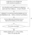
参见图2,介绍本发明方法的三个具体操作步骤:Referring to Fig. 2, three specific operation steps of the inventive method are introduced:
步骤1,初始化设置空间位置码本和位置测量样本库:在搭建和维护小区时,工程技术人员先在小区内的设定地点实测下述三个数据:位于该位置的路测终端发送的信号到达基站时间TOAl、基站接收该信号的功率Wl和该位置的平面坐标(xl,yl),其中自然数下标l为路测位置序号,并把上述三个数据构成路测终端数据向量(TOAl,Wl,(xl,yl));基站利用聚类方法对这些路测终端数据向量进行聚类处理后,建立由聚类点数据向量组成的初始化空间位置码本。因位置测量样本库只存储时间上最近的包括路测终端和待测终端的有限个终端数据向量,而在初始化时还没有待测终端数据向量,故选取若干个路测终端数据向量替代待测终端数据向量存储于位置测量样本库。
图2中的终端数据向量是本发明方法的基本处理单元,每个终端数据向量中的数据有三个:(TOA,W,(x,y)),其中,(x,y)为该终端位置的平面坐标,TOA和W分别是该终端发送到各基站的信号到达时间和基站接收该信号的功率。若有n个基站参与测量,则数据向量中对应有n组TOA和W的测量参数值。The terminal data vector among Fig. 2 is the basic processing unit of the inventive method, and the data in each terminal data vector has three: (TOA, W, (x, y)), wherein, (x, y) is this terminal position The plane coordinates of , TOA and W are respectively the arrival time of the signal sent by the terminal to each base station and the power received by the base station. If there are n base stations participating in the measurement, the data vector corresponds to n groups of measurement parameter values of TOA and W.
参见图3,介绍该步骤1中的基站利用聚类方法对路测终端数据向量进行聚类,建立初始化的由聚类点数据向量组成的空间位置码本的下列操作内容:Referring to Fig. 3, the base station in
(11)根据小区的地理环境,在小区内设置若干个平面坐标为
(12)分别对每个路测终端数据向量寻找与其平面坐标位置最近的聚类点,并将其归属于该聚类点;再将归属于同一聚类点的路测终端数据向量形成一个聚类群,使得每个聚类点都与一个聚类群相对应;(12) Find the nearest clustering point for each drive test terminal data vector and assign it to the cluster point; then form a clustering point with the drive test terminal data vectors belonging to the same cluster point Clusters, so that each cluster point corresponds to a cluster group;
(13)分别计算每个聚类群平面坐标的均值,作为本次聚类迭代后的聚类点
(14)按照下式计算和判断本次聚类迭代后的聚类点平面坐标与其迭代前的聚类点平面坐标的均方误差值E是否小于设定阈值:

(15)根据信道传播模型和该聚类点的平面坐标(xc,yc),计算该聚类点的信号到达时间和接收信号功率Wc=WTx-Lc,并以该聚类点数据向量(TOAc,Wc,(xc,yc))的形式存储于空间位置码本;式中,(xn,yn)为序号为n的基站平面坐标,V为光速,WTx为终端信号发送功率、且为固定值,Lc为该聚类点与基站间的传播路径损耗,该传播路径损耗数值是根据实际应用的传播模型,利用基站与该聚类点之间的距离计算得到的。(15) According to the channel propagation model and the plane coordinates (xc , yc ) of the cluster point, calculate the signal arrival time of the cluster point and received signal power Wc =WTx -Lc , and stored in the spatial position codebook in the form of the clustering point data vector (TOAc , Wc , (xc , yc )); where (xn , yn ) is the plane coordinates of the base station with serial number n, V is the speed of light, WTx is the transmission power of the terminal signal and is a fixed value, Lc is the propagation path loss between the cluster point and the base station, and the propagation path loss The value is calculated according to the propagation model used in practice, using the distance between the base station and the cluster point.
对于位置测量样本库,其功能是存储时间上最近的有限个终端数据向量,包括路测终端和待测终端的数据向量。其存储空间分为两部分:路测终端数据库和待测终端数据库,分别对应存储路测终端数据向量和待测终端数据向量。由于初始化时还没有待测终端数据向量,则待测终端数据库为空,而路测终端数据库则可选取若干个路测终端数据向量存于其中。As for the position measurement sample library, its function is to store the latest finite number of terminal data vectors, including the data vectors of drive test terminals and terminals to be tested. Its storage space is divided into two parts: a database of drive test terminals and a database of terminals to be tested, which respectively store data vectors of drive test terminals and data vectors of terminals to be tested. Since there is no data vector of the terminal to be tested at the time of initialization, the database of the terminal to be tested is empty, and several data vectors of the drive test terminal can be selected and stored in the database of the drive test terminal.
步骤2,估计待测终端位置:当网络中有待测终端发起定位请求时,各基站根据接收到的待测终端信号计算该待测终端信号到达基站时间TOAe和该信号的接收功率We,并将这两个测量数据与该待测终端的平面坐标(xe,ye)构成待测终端数据向量(TOAe,We,(xe,ye)),其中自然数下标e为待测终端序号;因此时该待测终端平面坐标(xe,ye)未知,故初始化设置其平面坐标(xe,ye)为该小区中心位置;接着,以TOAe和We两个测量数据为参数,在空间位置码本中搜寻与该待测终端数据向量最接近的聚类点数据向量,并将该聚类点数据向量中的平面坐标作为该待测终端的初始位置估计值


该步骤2包括下列操作内容:This
(21)估计待测终端的初始位置:先以每个待测终端的TOAe和We值为参数,在空间位置码本中搜寻与该待测终端数据向量最接近的聚类点数据向量,并将该聚类点数据向量中的平面坐标作为待测终端的初始位置估计值对于辅助定位的虚拟终端,则以其数据向量中的平面位置坐标作为初始位置估计值
该步骤(21)的具体操作内容如下所述:The concrete operation content of this step (21) is as follows:
(211)对小区内的每个待测终端,以其数据向量(TOAe,We,(xe,ye))中的TOAe和We为参数,以等效欧式距离为衡量基准,在空间位置码本中搜寻与其最接近的聚类点数据向量(TOAc,Wc,(xc,yc));因TOA与W两者量纲不同而无法直接计算,故先统一量纲:将TOA和W都转换为长度单位,根据信号传播模型,分别由We和TOAe计算得到待测终端与基站的估算距离和同样地,也在空间位置码本中计算得到聚类点与基站的估算距离

(212)根据等效欧式距离计算公式:
(213)遍历空间位置码本,选取其中等效欧式距离εe,c最小的聚类点数据向量中的位置坐标(xc,yc)作为待测终端的初始位置估计值对于辅助定位的虚拟终端的初始位置估计值则为其数据向量中的平面位置坐标。(213) Traversing the spatial position codebook, selecting the position coordinates (xc , yc ) in the data vector of the cluster point with the smallest equivalent Euclidean distance εe, c as the estimated initial position value of the terminal to be tested Initial position estimates for assisted localization virtual terminals is the plane position coordinates in its data vector.
(22)计算任意两个终端间的近似距离初始值:根据各个待测终端数据向量和虚拟终端数据向量中的信号到达时间TOA和信号接收功率W,采用最小二乘法得到各个待测终端和虚拟终端的粗略坐标,进而计算得到包括待测终端和虚拟终端的全部终端中任意两个终端之间的近似距离初始值。(22) Calculate the initial value of the approximate distance between any two terminals: according to the signal arrival time TOA and signal received power W in each terminal data vector and virtual terminal data vector, use the least squares method to obtain each terminal to be tested and virtual terminal The rough coordinates of the terminal, and then calculate the initial value of the approximate distance between any two terminals among all the terminals including the terminal to be tested and the virtual terminal.
该步骤(22)的具体操作内容如下所述:The concrete operation content of this step (22) is as follows:
(221)对包括待测终端和虚拟终端的全部终端中的每个终端,分别根据其数据向量中序号为n的某个基站对应的TOA和W,列出其距离计算公式:

(222)针对不同序号的基站,分别设置至少3个上述距离计算公式,并作为联立方程,用最小二乘法计算包括待测终端和虚拟终端的每个终端的粗略坐标(222) For base stations with different serial numbers, set at least three of the above-mentioned distance calculation formulas, and use the least squares method to calculate the rough coordinates of each terminal including the terminal to be tested and the virtual terminal as simultaneous equations
(223)根据每个终端的粗略坐标,直接计算包括待测终端和虚拟终端的全部终端中任意两个终端之间的近似距离初始值式中,自然数下标i和j分别为包括待测终端和虚拟终端的所有终端中的两个不同终端的序号,自然数上标k为后续步骤中的迭代计算次数,初始值k=0,表示未迭代。(223) According to the rough coordinates of each terminal, directly calculate the approximate distance initial value between any two terminals in all terminals including the terminal to be tested and the virtual terminal In the formula, the natural number subscripts i and j are respectively the sequence numbers of two different terminals among all terminals including the terminal to be tested and the virtual terminal, and the natural number superscript k is the number of iterative calculations in subsequent steps, and the initial value k=0, indicating Not iterated.
(23)采用和积算法计算待测终端的最终位置估计值:假设每个待测终端和虚拟终端的位置分布都是以步骤(21)得到初始位置估计值为中心的二维高斯分布,再结合步骤(22)得到的包括待测终端和虚拟终端的全部终端中任意两个终端之间的近似距离初始值,然后采用和积算法迭代多次后,获得各个待测终端的最终位置估计值;并由基站将最终位置估计值发送给各个待测终端。(23) Using the sum-product algorithm to calculate the final position estimate of the terminal to be tested: assuming that the position distribution of each terminal to be tested and the virtual terminal is a two-dimensional Gaussian distribution centered on the initial position estimate obtained in step (21), and then Combining the initial value of the approximate distance between any two terminals in all terminals including the terminal to be tested and the virtual terminal obtained in step (22), and then using the sum-product algorithm to iterate several times, the final estimated position of each terminal to be tested is obtained ; and the base station sends the final position estimation value to each terminal under test.
该步骤(23)的具体操作内容如下所述(参见图4的流程和图5的原理图):The specific operation content of this step (23) is as follows (referring to the flow chart of Fig. 4 and the schematic diagram of Fig. 5):
(231)因每个待测终端和虚拟终端的初始位置分布概率Pi(x,y)都是以步骤(21)得到的初始位置估计值为中心的二维高斯分布,其方差取决于实际测量误差;故初始化设置包括待测终端和虚拟终端的每个终端UEi的位置分布概率
(232)对于每个终端UEi和另一个终端UEj,执行下述迭代操作:以第k-1次迭代后的另一个终端UEj位置分布概率为基准,根据第k-1次迭代后的这两个终端UEi与UEj之间的近似距离


根据另一个终端UEj坐标(xj,yj)位于小区中的不同位置,分别计算该终端UEi的不同位置分布概率,再把终端UEi的上述所有位置分布概率数值进行累加之和,作为第k次迭代时,另一个终端UEj对终端UEi的位置分布概率的修正值
(233)每个终端UEi都将其初始位置坐标Pi(xi,yi)与所有其他终端对其位置分布概率的修正值


(234)先计算每个终端UEi的平面坐标在辅助位置分布概率下的期望值,即其多个平面坐标的均值,得到第k次迭代后,该终端UEi的位置坐标

(235)每个待测终端UEi的最终位置分布概率

(236)基站将每个待测终端UEi的最终位置估计值发送给各个待测终端。(236) The base station sends the final position estimation value of each UEi to be tested to each terminal to be tested.
图5中,Pi为任意一个终端UEi初始位置分布概率,


前面的描述利用了位置测量样本库中的一些虚拟终端,每个虚拟终端都参与了所有的迭代计算。为了充分利用位置测量样本库存储的数据信息,对上述处理流程可以做下述改进:令每次迭代计算都由不同的虚拟终端参与(如图6所示),例如,假设位置测量样本库中存储有100个数据向量,每次迭代时,从中选取10个作为虚拟终端参与迭代计算;下次迭代则选取另外10个,这样只需迭代计算10次,就可利用到位置测量样本库中所有的100个数据向量,在不提高计算复杂度的情况下,最大限度地利用了已有的数据信息。The previous description utilizes some virtual terminals in the position measurement sample library, and each virtual terminal participates in all the iterative calculations. In order to make full use of the data information stored in the position measurement sample library, the following improvements can be made to the above-mentioned processing flow: let each iterative calculation be participated by different virtual terminals (as shown in Figure 6), for example, assuming that in the position measurement sample library There are 100 data vectors stored, and in each iteration, 10 of them are selected as virtual terminals to participate in iterative calculation; in the next iteration, another 10 are selected, so that only 10 iterative calculations are required to use all the vectors in the position measurement sample library. The 100 data vectors of , maximize the use of existing data information without increasing the computational complexity.
步骤3,实时更新空间位置码本和位置测量样本库:因位置测量样本库中的待测终端数据库和路测终端数据库的更新是彼此独立的,故要存储新的待测终端数据向量或路测终端数据向量时,都是分别取代各自数据库中时间最久的数据向量,完成数据更新;然后,采用更新后的位置测量样本库中的路测终端和待测终端数据向量,重新进行聚类,获得新的聚类点后,再将新的聚类点对应的数据向量存入空间位置码本,完成空间位置码本的更新。
该步骤3包括下列具体操作内容:This
(31)网络中产生新的待测终端数据向量或路测终端数据向量,就开始更新位置测量样本库:若位置测量样本库中待测终端数据库的存储空间未满,就将该新的待测终端数据向量直接存储进去;否则,就将新的待测终端数据向量替代待测终端数据库中存储时间最久的数据向量;路测终端数据向量的更新方法与待测终端数据向量相同,这样使得位置测量样本库中始终存储有时间最近的有限个待测终端和路测终端数据向量(参见图7所示);(31) When a new data vector of a terminal to be tested or a data vector of a drive test terminal is generated in the network, the position measurement sample database is started to be updated: if the storage space of the database of the terminal to be tested in the position measurement sample database is not full, the new data vector of the terminal to be tested is updated. The data vector of the terminal to be tested is directly stored in; otherwise, the new data vector of the terminal to be tested is replaced by the data vector of the longest storage time in the database of the terminal to be tested; the update method of the data vector of the drive test terminal is the same as that of the terminal to be tested, so that Make the location measurement sample library always store the latest finite number of terminal to be tested and drive test terminal data vectors (see Figure 7);
从图7中可看到:待测终端数据库的更新周期Te与路测终端数据库的更新周期Tl是不同的,且取决于具体实际情况。通常情况下,由于待测终端的测量更加频繁,其更新周期较短;对于路测终端数据库,往往是由于小区内地理环境的变化(如新建房屋等),需要再次进行实际路测才对其更新,故更新周期较长。It can be seen from FIG. 7 that the update period Te of the database of the terminal to be tested is different from the update period Tl of the database of the drive test terminal, and depends on specific actual conditions. Usually, due to the more frequent measurement of the terminal to be tested, its update cycle is shorter; for the drive test terminal database, it is often due to changes in the geographical environment in the community (such as new houses, etc.), and the actual drive test is required again. update, so the update cycle is longer.
(32)完成位置测量样本库的更新后,就根据更新后的位置测量样本库中的路测终端和待测终端数据向量,通过聚类方法,完成空间位置码本的更新。该步骤(32)包括下列具体操作内容(参见图8所示):(32) After the update of the location measurement sample library is completed, the update of the spatial location codebook is completed through the clustering method according to the data vectors of the drive test terminal and the terminal to be tested in the updated location measurement sample library. This step (32) includes the following specific operation content (seeing as shown in Figure 8):
(321)将更新前的空间位置码本中的数据向量作为聚类点初始值;(321) Using the data vector in the spatial position codebook before updating as the initial value of the cluster point;
(322)对位置测量样本库中的每个路测终端和待测终端的数据向量,分别计算与其等效欧式距离最小的聚类点,并将其归属于该聚类点;使得归属于同一聚类点的待测终端和路测终端的数据向量形成一个聚类群,即每个聚类点都与一个聚类群相对应;计算等效欧式距离时的各个数据量纲要统一;(322) For the data vectors of each drive test terminal and the terminal to be tested in the position measurement sample library, calculate the cluster point with the smallest equivalent Euclidean distance to it, and attribute it to the cluster point; make it belong to the same The data vectors of the terminals to be tested and the drive test terminals at the cluster points form a cluster group, that is, each cluster point corresponds to a cluster group; the outline of each data volume when calculating the equivalent Euclidean distance is unified;
(323)计算每个聚类群中的待测终端和路测终端的数据向量的各项测量数据的均值,得到本次聚类迭代后的聚类点;(323) Calculate the mean value of each measurement data of the data vector of the terminal to be tested and the drive test terminal in each cluster group, and obtain the cluster points after this clustering iteration;
(324)计算和判断本次聚类迭代后的聚类点与其聚类迭代前的聚类点的均方误差是否小于设定阈值,若是,则将该聚类点数据向量存入空间位置码本,完成空间位置码本的更新;否则,返回执行步骤(322)。(324) Calculate and judge whether the mean square error between the clustering points after this clustering iteration and the clustering points before the clustering iteration is less than the set threshold, if so, store the clustering point data vector into the spatial position code This, complete the update of the spatial location codebook; otherwise, return to the execution step (322).
本发明已进行多次实施例仿真实验和模拟,本发明方法仿真的网络小区布局如图9中的蜂窝小区cell 0所示,该小区半径为1km,中心设置1个基站,坐标为(0,0),小区分为96个小正三角形,每个小正三角形中心设置为聚类点,这样,共有96个聚类点。仿真实施例中的TOA和接收信号功率W的测量值分别以cell 0,cell 5和cell 6的基站为基准进行模拟测试而得到的。The present invention has carried out embodiment emulation experiment and simulation for many times, and the network cell layout of the emulation of the present invention's method is as shown in the
在小区cell 0内随机选取30个点,其平面坐标服从方差为5000的二维高斯分布,其中15个点的二维高斯分布中心为(50,100),其余15个点的二维高斯分布中心为(-50,80)。再从30个点中随机选取20个为待测终端,另外10个作为虚拟终端。Randomly select 30 points in
为了模拟实际网络中的路测终端数据向量,在该小区cell 0中随机分布798个路测采样点,这些路测采样点都服从方差为5000的二维高斯分布,分布中心分别为(50,100)、(-50,80)、(-40,-90)和(45,-105)。In order to simulate the drive test terminal data vector in the actual network, 798 drive test sampling points are randomly distributed in the
在实际的移动通信网络中,由于传播环境中的多径和阴影衰落等影响,基站对移动终端的测量数据TOA和W都会存在一定的误差,从而导致计算得出终端与基站的距离与角度也都存在误差:式中,V为光速3×10⁸m,d为终端与基站之间的距离真值,TOA为信号到达时间测量值,nTOA为测量误差,W为接收信号功率测量值,WTx为发送信号功率,C为天线高度等参数,在特定场景中为固定值,nW为多径和阴影衰落等因素造成的测量误差。In the actual mobile communication network, due to the influence of multipath and shadow fading in the propagation environment, the base station will have certain errors in the measurement data TOA and W of the mobile terminal, which leads to the calculation of the distance and angle between the terminal and the base station. There are errors: In the formula, V is the speed of light 3×10⁸ m, d is the true distance between the terminal and the base station, TOA is the signal arrival time measurement value, nTOA is the measurement error, W is the received signal power measurement value, WTx is the transmission Signal power, C is the antenna height and other parameters, it is a fixed value in a specific scene, nW is the measurement error caused by factors such as multipath and shadow fading.
为模拟这些误差,仿真中的TOA和W的测量误差nTOA和nW分别服从
仿真一:(σTOA,σW)取值为(2.67ns,3.163dB)时,仿真100次的待测终端均方根误差曲线如图10所示,为了对定位结果进行比较,在相同仿真条件下,还采用传统的TOA定位方法(最小二乘法)进行仿真测试。Simulation 1: When the value of (σTOA , σW ) is (2.67ns, 3.163dB), the root mean square error curve of the terminal under test after 100 simulations is shown in Figure 10. In order to compare the positioning results, in the same simulation Under the condition, the traditional TOA positioning method (least square method) is also used for simulation test.
从图10中可见,本发明定位方法与传统的TOA定位方法相比较:定位精度明显提高,迭代计算5次后,待测终端定位结果的均方根误差约为102m,而同样条件下TOA定位方法的均方根误差约128m。另外,迭代3次左右,本发明定位方法的误差曲线就趋于平缓。It can be seen from Figure 10 that the positioning method of the present invention is compared with the traditional TOA positioning method: the positioning accuracy is significantly improved. After 5 iterations, the root mean square error of the positioning result of the terminal to be tested is about 102m, while TOA positioning under the same conditions The root mean square error of the method is about 128m. In addition, after about 3 iterations, the error curve of the positioning method of the present invention tends to be gentle.
由上述仿真结果可以看到,本发明移动通信网络中的基于位置测试样本的群定位技术是可行的,通过利用空间位置码本和位置测量样本库,结合当前的多个终端测量数据,可充分利用基站对终端的测量信息,获得较好的定位性能。而且本发明方法所用到的数据仅为TOA和接收信号功率两个测量数据,很容易获取,在GSM等现行使用的移动通信网络中都可适用。From the above simulation results, it can be seen that the group positioning technology based on the location test samples in the mobile communication network of the present invention is feasible, by using the spatial location codebook and the location measurement sample library, combined with the current multiple terminal measurement data, it can fully The measurement information of the base station to the terminal is used to obtain better positioning performance. Moreover, the data used by the method of the present invention are only two measurement data of TOA and received signal power, which are easy to obtain and are applicable to currently used mobile communication networks such as GSM.
以上所述仅为本发明的较佳实施例而已,并不用以限制本发明,凡在本发明的精神和原则之内,所做的任何修改、等同替换、改进等,均应包含在本发明保护的范围之内。The above descriptions are only preferred embodiments of the present invention, and are not intended to limit the present invention. Any modifications, equivalent replacements, improvements, etc. made within the spirit and principles of the present invention shall be included in the present invention. within the scope of protection.
Claims (10)
Translated fromChinese


Priority Applications (1)
| Application Number | Priority Date | Filing Date | Title |
|---|---|---|---|
| CN 201110192635CN102291817B (en) | 2011-07-11 | 2011-07-11 | Group positioning method based on location measurement sample in mobile communication network |
Applications Claiming Priority (1)
| Application Number | Priority Date | Filing Date | Title |
|---|---|---|---|
| CN 201110192635CN102291817B (en) | 2011-07-11 | 2011-07-11 | Group positioning method based on location measurement sample in mobile communication network |
Publications (2)
| Publication Number | Publication Date |
|---|---|
| CN102291817Atrue CN102291817A (en) | 2011-12-21 |
| CN102291817B CN102291817B (en) | 2013-10-16 |
Family
ID=45337857
Family Applications (1)
| Application Number | Title | Priority Date | Filing Date |
|---|---|---|---|
| CN 201110192635Expired - Fee RelatedCN102291817B (en) | 2011-07-11 | 2011-07-11 | Group positioning method based on location measurement sample in mobile communication network |
Country Status (1)
| Country | Link |
|---|---|
| CN (1) | CN102291817B (en) |
Cited By (14)
| Publication number | Priority date | Publication date | Assignee | Title |
|---|---|---|---|---|
| CN102739329A (en)* | 2012-06-25 | 2012-10-17 | 中国科学院上海微系统与信息技术研究所 | Method for establishing path loss model of light rail line road sensor network |
| CN102857942A (en)* | 2012-09-06 | 2013-01-02 | 哈尔滨工业大学 | Uncertainty data flow cluster based dynamic communication distance estimating method |
| CN103997783A (en)* | 2014-05-14 | 2014-08-20 | 无锡北邮感知技术产业研究院有限公司 | Outdoor cluster matching and positioning method and device |
| CN104981011A (en)* | 2014-04-14 | 2015-10-14 | 李巍岳 | WiFi (Wireless Fidelity) hotspot data acquisition and updating method based on sequential processing |
| CN106341886A (en)* | 2016-10-20 | 2017-01-18 | 河海大学常州校区 | Cooperative positioning method based on sequential consistent weighted sum-product algorithm |
| CN106455056A (en)* | 2016-11-14 | 2017-02-22 | 百度在线网络技术(北京)有限公司 | Positioning method and device |
| CN107798383A (en)* | 2017-10-27 | 2018-03-13 | 天津大学 | Improved core extreme learning machine localization method |
| CN108702729A (en)* | 2016-08-31 | 2018-10-23 | 华为技术有限公司 | Build the method and device of wireless location feature database |
| CN109257703A (en)* | 2018-10-09 | 2019-01-22 | 江苏满运软件科技有限公司 | Display method, device, electronic device, and storage medium for driver gathering point |
| CN110139303A (en)* | 2019-04-23 | 2019-08-16 | 四川九洲电器集团有限责任公司 | A kind of rapid simulation method and device of equivalent signal grade TOA measurement |
| CN110708702A (en)* | 2019-09-03 | 2020-01-17 | 中国联合网络通信集团有限公司 | Method and device for determining signal propagation model |
| CN112235807A (en)* | 2020-12-16 | 2021-01-15 | 上海特金信息科技有限公司 | Networking method, device, equipment and medium of TDOA monitoring system |
| CN112601173A (en)* | 2020-11-30 | 2021-04-02 | 西安电子科技大学 | 5G positioning truth value detection and attack tracing method, system, equipment and application |
| CN117500045A (en)* | 2023-12-29 | 2024-02-02 | 环球数科集团有限公司 | An LDSW ultra-low power artificial intelligence communication positioning system |
Citations (4)
| Publication number | Priority date | Publication date | Assignee | Title |
|---|---|---|---|---|
| US20050078033A1 (en)* | 2003-10-14 | 2005-04-14 | Hitachi, Ltd. | System and method for position detection of a terminal in a network |
| CN1980417A (en)* | 2005-11-30 | 2007-06-13 | 中兴通讯股份有限公司 | Method for realizing positioning in digit clustering communication system |
| US20080122689A1 (en)* | 2006-06-30 | 2008-05-29 | Ntt Docomo, Inc. | Position determination system and position determination method |
| CN101616482A (en)* | 2009-07-31 | 2009-12-30 | 北京邮电大学 | A positioning method in a mobile communication system, a mobile terminal, and a positioning server |
- 2011
- 2011-07-11CNCN 201110192635patent/CN102291817B/ennot_activeExpired - Fee Related
Patent Citations (4)
| Publication number | Priority date | Publication date | Assignee | Title |
|---|---|---|---|---|
| US20050078033A1 (en)* | 2003-10-14 | 2005-04-14 | Hitachi, Ltd. | System and method for position detection of a terminal in a network |
| CN1980417A (en)* | 2005-11-30 | 2007-06-13 | 中兴通讯股份有限公司 | Method for realizing positioning in digit clustering communication system |
| US20080122689A1 (en)* | 2006-06-30 | 2008-05-29 | Ntt Docomo, Inc. | Position determination system and position determination method |
| CN101616482A (en)* | 2009-07-31 | 2009-12-30 | 北京邮电大学 | A positioning method in a mobile communication system, a mobile terminal, and a positioning server |
Cited By (21)
| Publication number | Priority date | Publication date | Assignee | Title |
|---|---|---|---|---|
| CN102739329A (en)* | 2012-06-25 | 2012-10-17 | 中国科学院上海微系统与信息技术研究所 | Method for establishing path loss model of light rail line road sensor network |
| CN102857942A (en)* | 2012-09-06 | 2013-01-02 | 哈尔滨工业大学 | Uncertainty data flow cluster based dynamic communication distance estimating method |
| CN102857942B (en)* | 2012-09-06 | 2015-06-24 | 哈尔滨工业大学 | Uncertainty data flow cluster based dynamic communication distance estimating method |
| CN104981011B (en)* | 2014-04-14 | 2019-11-29 | 李巍岳 | The acquisition of Wi-Fi hotspot data and update method based on Sequential processing |
| CN104981011A (en)* | 2014-04-14 | 2015-10-14 | 李巍岳 | WiFi (Wireless Fidelity) hotspot data acquisition and updating method based on sequential processing |
| CN103997783A (en)* | 2014-05-14 | 2014-08-20 | 无锡北邮感知技术产业研究院有限公司 | Outdoor cluster matching and positioning method and device |
| CN103997783B (en)* | 2014-05-14 | 2017-03-29 | 无锡北邮感知技术产业研究院有限公司 | A kind of outdoor cluster match localization method and device |
| CN108702729A (en)* | 2016-08-31 | 2018-10-23 | 华为技术有限公司 | Build the method and device of wireless location feature database |
| CN106341886A (en)* | 2016-10-20 | 2017-01-18 | 河海大学常州校区 | Cooperative positioning method based on sequential consistent weighted sum-product algorithm |
| CN106455056A (en)* | 2016-11-14 | 2017-02-22 | 百度在线网络技术(北京)有限公司 | Positioning method and device |
| CN107798383A (en)* | 2017-10-27 | 2018-03-13 | 天津大学 | Improved core extreme learning machine localization method |
| CN107798383B (en)* | 2017-10-27 | 2021-11-26 | 天津大学 | Improved positioning method of nuclear extreme learning machine |
| CN109257703A (en)* | 2018-10-09 | 2019-01-22 | 江苏满运软件科技有限公司 | Display method, device, electronic device, and storage medium for driver gathering point |
| CN109257703B (en)* | 2018-10-09 | 2020-08-25 | 江苏满运软件科技有限公司 | Display method and device for driver gathering point, electronic equipment and storage medium |
| CN110139303A (en)* | 2019-04-23 | 2019-08-16 | 四川九洲电器集团有限责任公司 | A kind of rapid simulation method and device of equivalent signal grade TOA measurement |
| CN110708702A (en)* | 2019-09-03 | 2020-01-17 | 中国联合网络通信集团有限公司 | Method and device for determining signal propagation model |
| CN112601173A (en)* | 2020-11-30 | 2021-04-02 | 西安电子科技大学 | 5G positioning truth value detection and attack tracing method, system, equipment and application |
| CN112601173B (en)* | 2020-11-30 | 2021-10-08 | 西安电子科技大学 | 5G positioning truth detection and attack source tracing method, system, equipment and application |
| CN112235807A (en)* | 2020-12-16 | 2021-01-15 | 上海特金信息科技有限公司 | Networking method, device, equipment and medium of TDOA monitoring system |
| CN117500045A (en)* | 2023-12-29 | 2024-02-02 | 环球数科集团有限公司 | An LDSW ultra-low power artificial intelligence communication positioning system |
| CN117500045B (en)* | 2023-12-29 | 2024-03-15 | 环球数科集团有限公司 | LDSW ultra-low power consumption artificial intelligence communication positioning system |
Also Published As
| Publication number | Publication date |
|---|---|
| CN102291817B (en) | 2013-10-16 |
Similar Documents
| Publication | Publication Date | Title |
|---|---|---|
| CN102291817B (en) | Group positioning method based on location measurement sample in mobile communication network | |
| CN104469676B (en) | The localization method and system of a kind of mobile terminal | |
| CN107318084B (en) | Fingerprint positioning method and device based on optimal similarity | |
| CN101620270B (en) | Wireless location method based on cluster-fusion | |
| US10145933B2 (en) | Angle determining system and method | |
| CN103118333B (en) | Similarity based wireless sensor network mobile node positioning method | |
| CN108696932A (en) | It is a kind of using CSI multipaths and the outdoor fingerprint positioning method of machine learning | |
| CN105188082B (en) | For the evaluation method of RSS/AOA/TDOA positioning performances under indoor WLAN environment | |
| Shi | A new weighted centroid localization algorithm based on RSSI | |
| CN107241797B (en) | Single-station positioning method based on scatterer information in NLOS environment | |
| CN104396321B (en) | Method of locating terminal and positioning device | |
| CN103249144B (en) | A kind of wireless sensor network node locating method based on C type | |
| CN102625443B (en) | Method and device for positioning terminal | |
| CN106912105A (en) | 3-D positioning method based on PSO_BP neutral nets | |
| CN101616482A (en) | A positioning method in a mobile communication system, a mobile terminal, and a positioning server | |
| CN102395196A (en) | Positioning method and device based on calibration point | |
| CN111818634A (en) | A positioning method, positioning platform and user terminal in a 5G scenario | |
| CN106255203B (en) | MDS-based positioning method for terminal RSRP difference compensation | |
| CN108226860A (en) | Ultra wide band mixing dimension localization method and alignment system based on RSS | |
| CN106125043B (en) | A kind of localization method based on position location residual weighted | |
| CN107027148A (en) | A kind of Radio Map classification and orientation methods based on UE speed | |
| CN108650629A (en) | A kind of indoor three-dimensional location based on radio communication base station | |
| KR101749098B1 (en) | System for assuming position of base station and method for assuming position of base station thereof | |
| CN1722897A (en) | A method for locating mobile terminal in mobile communication | |
| Cui et al. | A novel iterative positioning method based on difference RSS model with 5G field experiments |
Legal Events
| Date | Code | Title | Description |
|---|---|---|---|
| C06 | Publication | ||
| PB01 | Publication | ||
| C10 | Entry into substantive examination | ||
| SE01 | Entry into force of request for substantive examination | ||
| C14 | Grant of patent or utility model | ||
| GR01 | Patent grant | ||
| CF01 | Termination of patent right due to non-payment of annual fee | Granted publication date:20131016 Termination date:20140711 | |
| EXPY | Termination of patent right or utility model |