CN102291435B - Mobile information searching and knowledge discovery system based on geographic spatiotemporal data - Google Patents
Mobile information searching and knowledge discovery system based on geographic spatiotemporal dataDownload PDFInfo
- Publication number
- CN102291435B CN102291435BCN201110199082ACN201110199082ACN102291435BCN 102291435 BCN102291435 BCN 102291435BCN 201110199082 ACN201110199082 ACN 201110199082ACN 201110199082 ACN201110199082 ACN 201110199082ACN 102291435 BCN102291435 BCN 102291435B
- Authority
- CN
- China
- Prior art keywords
- location
- information
- fence
- user
- network information
- Prior art date
- Legal status (The legal status is an assumption and is not a legal conclusion. Google has not performed a legal analysis and makes no representation as to the accuracy of the status listed.)
- Expired - Fee Related
Links
Images


Landscapes
- Information Transfer Between Computers (AREA)
- Information Retrieval, Db Structures And Fs Structures Therefor (AREA)
- Telephonic Communication Services (AREA)
Abstract
Translated fromChineseDescription
Translated fromChinese技术领域technical field
本发明涉及一种移动信息搜索及知识发现系统,尤其是涉及一种基于地理时空数据的移动信息搜索及知识发现系统。The invention relates to a mobile information search and knowledge discovery system, in particular to a mobile information search and knowledge discovery system based on geographical space-time data.
背景技术Background technique
空间位置及其连带的时间信息是反映人类日常生活行为的重要因素。在移动互联网应用高速发展的今天,新一代智能信息服务通过位置时空信息可以更好地理解用户行为,继而不断提升其服务质量。近年来,定位技术与移动互联网相结合,形成了一类称之为“基于位置的服务(Location-Based Service,LBS)(也称位置服务)”的新型移动计算服务模式。这些服务以卫星定位、无线网络定位等多种方式为基础获取用户时空信息,并对大众时空数据进行分析挖掘,最终在用户智能手机、PDA、PND等移动终端设备上实现对用户的自适应表达,满足用户周边兴趣点搜索导航、信息获取、社会交流等广泛需求,是下一代智慧地球及智能社会的核心组件。LBS技术及服务模式已经衍生出了一个蓬勃发展的,以兴趣及创意为核心价值观的新兴信息产业。Spatial location and its associated temporal information are important factors that reflect human behavior in daily life. Today, with the rapid development of mobile Internet applications, a new generation of intelligent information services can better understand user behavior through location and space-time information, and then continuously improve its service quality. In recent years, the combination of positioning technology and mobile Internet has formed a new type of mobile computing service model called "Location-Based Service (LBS) (also called location service)". These services obtain user spatio-temporal information based on various methods such as satellite positioning and wireless network positioning, analyze and mine public spatio-temporal data, and finally realize adaptive expression of users on mobile terminal devices such as smart phones, PDAs, and PNDs. , to meet a wide range of needs such as search and navigation of points of interest around users, information acquisition, social communication, etc., is the core component of the next generation of smart earth and smart society. LBS technology and service model have derived a flourishing emerging information industry with interest and creativity as its core values.
人类的日常生产生活天然地产生了大量位置时空数据。通过定位技术将这些数据搜集并分析,最终以服务的形式反馈回人类社会,将有效指导人类社会活动。在网络计算即将出现深层变革的今天,位置信息不再只停留在数据层面,而具有丰富的社会属性和社会意义。位置时空信息的引入,必然改变当前诸多信息系统带给人们的用户体验,使得人类信息系统朝着智能化和普适化的方向迈进。The daily production and life of human beings naturally generate a large amount of location spatiotemporal data. Collect and analyze these data through positioning technology, and finally feed back to human society in the form of service, which will effectively guide human social activities. Today, when network computing is about to undergo profound changes, location information is no longer just at the data level, but has rich social attributes and social significance. The introduction of location and space-time information will inevitably change the user experience brought by many current information systems, and make human information systems move towards intelligence and universalization.
传统LBS主要集中在位置导航相关应用方面,相应的位置信息、热点事件、兴趣事件等依靠专门方法和专业人员进行维护,这种模式严重制约了位置服务的发展空间。事实上现有的互联网海量信息中存在着大量的位置信息元数据,现有的基于计算机网络的信息发布及获取模式也天然携带了位置元素。因此,位置服务本身并不缺少位置背后的社会信息,而是缺少一个有效整合和挖掘这些信息的知识本体及挖掘方法。Traditional LBS mainly focuses on location-based navigation-related applications, and the corresponding location information, hot events, interest events, etc. are maintained by specialized methods and professionals. This model seriously restricts the development space of location-based services. In fact, there is a large amount of location information metadata in the existing mass information on the Internet, and the existing computer network-based information publishing and acquisition models also naturally carry location elements. Therefore, the location service itself does not lack the social information behind the location, but lacks a knowledge ontology and mining method to effectively integrate and mine these information.
当前地理时空围栏是LBS服务的一个重要应用模式。传统地理围栏技术主要用于位置区域监控。本发明将地理围栏技术延伸为时空位置围栏技术,并用于信息搜索及知识发现。因此,传统的由专家构建围栏的模式已经不适合新型LBS服务的需求。At present, geographical space-time fence is an important application mode of LBS service. Traditional geofencing technology is mainly used for location area monitoring. The invention extends the geographic fence technology to the space-time location fence technology, and uses it for information search and knowledge discovery. Therefore, the traditional mode of building fences by experts is no longer suitable for the needs of new LBS services.
发明内容Contents of the invention
本发明主要解决将位置信息引入网络信息搜素,形成自适应用户位置的移动信息搜素所存在的技术问题;提供了一种在公众定位导航设备普及的情况下(如智能手机),根据用户当前的坐标、时间、高度、方向等位置数据以及地理围栏的社会关联性挖掘结果,重新组织并提供用户感兴趣的网络信息,形成基于用户位置的信息自适应表达的一种基于地理时空数据的移动信息搜索及知识发现系统。The present invention mainly solves the technical problems of introducing location information into network information search to form a mobile information search that adapts to the user's location; The current coordinates, time, height, direction and other location data and the social correlation mining results of geofences reorganize and provide network information that users are interested in, forming a self-adaptive expression based on user location information based on geographic space-time data. Mobile information search and knowledge discovery system.
本发明的上述技术问题主要是通过下述技术方案得以解决的:Above-mentioned technical problem of the present invention is mainly solved by following technical scheme:
一种基于地理时空数据的移动信息搜索及知识发现系统,其特征在于,包括:A mobile information search and knowledge discovery system based on geographical space-time data, characterized in that it includes:
信息搜索服务器:采用Hadoop并行集群架构,运用网络爬虫采集工具进行并行网络信息的采集,根据网络信息爬行入口生成若干爬行任务,依照Hadoop并行集群架构划分给各处理机去获取页面,并对页面文件进行格式解析,爬行深度由系统设置;Information search server: Adopt Hadoop parallel cluster architecture, use web crawler collection tools to collect parallel network information, generate several crawling tasks according to the crawling entrance of network information, divide them into each processor to obtain pages according to Hadoop parallel cluster architecture, and process the page files Perform format analysis, and the crawling depth is set by the system;
知识发现服务器:根据用户定义将地理区域划分为若干位置围栏,同时接收上述信息搜索服务器采集的网络信息,通过位置知识本体对其中包含有多个位置围栏及其附属的相关概念的位置知识进行挖掘提取后给网络信息增加与该位置知识对应的位置标签,并将其以索引形式存储到知识发现服务器数据池中,该知识发现服务器根据网络信息的位置标签,将网络信息摘要映射到各个已设置好的位置围栏中,所述网络信息的摘要包括:标题,时间,正文前若干字,出处网址URL,所述正文前若干字根据用户设定;Knowledge Discovery Server: Divide the geographical area into several location fences according to the user definition, and receive the network information collected by the above information search server at the same time, and mine the location knowledge containing multiple location fences and their associated concepts through the location knowledge ontology After extraction, add a location label corresponding to the location knowledge to the network information, and store it in the data pool of the knowledge discovery server in the form of an index. The knowledge discovery server maps the summary of the network information to each set In the good location fence, the summary of the network information includes: title, time, some words before the text, the URL of the source website, and the first few words of the text are set by the user;
信息推送服务器:将根据用户所在位置与上述知识发现服务器数据池中的位置知识本体中各个位置围栏的归属匹配结果,从所述知识发现服务器数据池中提取符合该位置的网络信息摘要,组织该网络信息摘要的发布顺序,对用户实现基于位置的网络信息自适应推送;Information push server: According to the attribution matching results between the user's location and the fences of each location in the location knowledge ontology in the knowledge discovery server data pool, extract the network information summary corresponding to the location from the knowledge discovery server data pool, and organize the The release sequence of network information summaries realizes location-based adaptive push of network information to users;
客户端:通过GPS定位芯片获得用户所在位置信息,并利用无线网络将位置信息发送给信息推送服务器,同时能接收所述信息推送服务器所推送的网络信息摘要,并将其显示在所述客户端上。Client: Obtain the location information of the user through the GPS positioning chip, and use the wireless network to send the location information to the information push server, and at the same time receive the summary of network information pushed by the information push server, and display it on the client superior.
本发明涉及一种基于位置的移动信息搜索和知识发现系统,以位置微博的形式体现。系统分为服务器软件和客户端软件两部分组成。The invention relates to a location-based mobile information search and knowledge discovery system, embodied in the form of location microblogs. The system is divided into server software and client software.
本发明客户端基于Android和ios智能手机设备(两个实现版本),能够获取用户当前所在的坐标、时间、高度、方向等位置数据,并能通过3G网络将这些数据提供给服务器。客户端同时能从服务器下载用户感兴趣的或用户周边的地理围栏网络信息的摘要,用于通过移动客户端浏览信息。The client of the present invention is based on Android and ios smart phone devices (two implementation versions), and can obtain location data such as the user's current coordinates, time, height, direction, etc., and can provide these data to the server through the 3G network. At the same time, the client can download a summary of the geo-fence network information that the user is interested in or around the user from the server, and is used to browse information through the mobile client.
本发明能够建立“中心-区域式”围栏或者地理多边形围栏。地理围栏可由用户通过手机客户端自行设置,也可通过从网络信息中提取的位置信息自动设置。“中心-区域式”围栏以一个地理坐标为圆心,以半径确定围栏范围。地理多边形围栏根据地图标注的实际道路、建筑属性进行设置。地理围栏采用树形层次化管理,并提供一种多粒度分层聚类方法,根据地理围栏的社会属性及围栏在同一网页中出现的次数等,将围栏进行聚类归并,形成聚类层次树。The present invention is capable of establishing "center-area" fences or geographic polygon fences. The geographical fence can be set by the user through the mobile phone client, or can be automatically set by the location information extracted from the network information. The "center-area" fence takes a geographical coordinate as the center, and the radius of the fence determines the range of the fence. The geographic polygon fence is set according to the actual road and building attributes marked on the map. Geographical fences are managed in tree form and provide a multi-granularity hierarchical clustering method. According to the social attributes of geographical fences and the number of times the fences appear in the same web page, etc., the fences are clustered and merged to form a clustering hierarchical tree .
本发明服务端基于Hadoop体系结构,具有并行数据采集、分析、索引和存储的云计算特征。系统能对中、英文两种语言进行网页全文检索和语言分析,提取网页信息中的位置关键字,并结合位置领域本体标注网页信息的多个位置标签。The server end of the present invention is based on the Hadoop architecture, and has the cloud computing feature of parallel data collection, analysis, indexing and storage. The system can perform full-text search and language analysis of web pages in Chinese and English, extract location keywords in web page information, and mark multiple location tags of web page information in combination with location field ontology.
本发明能在一个具体的知识范畴下,根据位置领域本体,自动搜索和提取该知识范畴下涉及位置的相关信息,建立若干地理围栏并将这些信息归并到相应的地理围栏中。系统能根据用户提供的具体知识范畴和用户搜索信息的位置、时间等相关数据,将与该知识范畴相关的网络信息进行重新组织。通过地理围栏社会属性的动态关联性挖掘组件,建立该知识范畴下网络信息与用户当前所处环境的关联度排序。并根据这种关联度将该知识范畴下的信息提供给用户,形成自适应表达。用户通过智能手机客户端软件进行浏览。The present invention can automatically search and extract location-related information under a specific knowledge category according to the ontology of the location domain, establish several geographic fences, and merge the information into corresponding geographic fences. The system can reorganize the network information related to the knowledge category according to the specific knowledge category provided by the user and relevant data such as the location and time of the user's search information. Through the dynamic correlation mining component of social attributes of geo-fences, the ranking of the correlation between network information and the user's current environment under this knowledge category is established. And according to the degree of correlation, the information under the knowledge category is provided to the user to form an adaptive expression. Users browse through the smart phone client software.
在上述的一种基于地理时空数据的移动信息搜索及知识发现系统,所述的信息搜索服务器包括一个预设的爬行数据库以及一个海量数据抓取模块,所述的海量数据抓取模块包括:In the above-mentioned mobile information search and knowledge discovery system based on geographical space-time data, the information search server includes a preset crawling database and a massive data capture module, and the massive data capture module includes:
网页追踪单元:将用户设定的网页URL地址注入到所述爬行数据库中,实现以该网页为入口的网络信息采集,爬行由该入口地址开始深度遍历有链接的网页,爬行最大深度由用户定义;Webpage Tracking Unit: Inject the URL address of the webpage set by the user into the crawling database to realize the collection of network information with the webpage as the entry. The crawling starts from the entry address and traverses the webpages with links in depth. The maximum depth of crawling is defined by the user ;
内容获取单元:根据爬虫爬行规则根据上述网页追踪单元设定的网页进行访问网页信息,将网页内容进行下载,获取网络信息内容;Content acquisition unit: according to the crawling rules of the crawler, access the webpage information according to the webpage set by the above-mentioned webpage tracking unit, download the webpage content, and obtain the network information content;
格式解析单元:根据上述下载的网络信息进行格式解析,分析页面的HTML格式,提取页面标题、正文及相关元数据内容,形成网络信息摘要,存储到一个设置在格式解析单元内的文本数据库中;Format analysis unit: perform format analysis according to the above-mentioned downloaded network information, analyze the HTML format of the page, extract the page title, body text and related metadata content, form a network information summary, and store it in a text database arranged in the format analysis unit;
爬行数据库更新单元:若发现上述内容获取单元中的网页URL地址有更新,则将其更新的网络URL地址存储到上述爬行数据库中。Crawling database updating unit: if it is found that the URL address of the webpage in the above-mentioned content acquisition unit is updated, then store the updated network URL address in the above-mentioned crawling database.
在上述的一种基于地理时空数据的移动信息搜索及知识发现系统,所述的知识发现服务器包括:In the above-mentioned mobile information search and knowledge discovery system based on geographical space-time data, the knowledge discovery server includes:
位置围栏管理模块:根据用户设定,将地理位置划分为若干位置围栏,并基于关联挖掘算法是确定两两位置围栏的关联度;Location fence management module: According to user settings, the geographical location is divided into several location fences, and based on the association mining algorithm, the correlation degree of two location fences is determined;
中文分词模块:所述中文分词模块内建一个通用语境下的中文辞典,然后通过词表切分并根据该中文辞典获得上述设置在格式解析单元内的文本数据库中网络信息的词汇元素;Chinese word segmentation module: the Chinese word segmentation module has a built-in Chinese dictionary under a general context, and then obtains the above-mentioned lexical elements of the network information in the text database set in the format analysis unit through vocabulary segmentation and according to the Chinese dictionary;
索引建立模块:根据所述中文分词模块获取的关键词建立以8位字节为基础的逆序索引文件格式,建立索引文件,并将索引文件进行存储;Index building module: according to the keyword that described Chinese participle module obtains, set up the reverse order index file format based on 8-bit bytes, set up index file, and store index file;
检索模块:根据位置知识本体运用布尔操作、模糊以及分组查询方式针对上述文本数据库中网络信息中的位置知识的查询,如果网络信息含有某些位置围栏相关的词汇,则将此网络信息标注该位置围栏的位置标签,将文本信息的摘要映射到位置围栏中,所述文本信息的摘要包括:标题,时间,正文前若干字,出处网址URL,所述正文前若干字根据用户设定。Retrieval module: use Boolean operations, fuzzy and group query methods to query the location knowledge in the network information in the above text database according to the location knowledge ontology. If the network information contains some words related to location fences, mark the location in the network information The location label of the fence maps the summary of the text information to the location fence. The summary of the text information includes: title, time, the first few words of the text, and the URL of the source website. The first few words of the text are set by the user.
在上述的一种基于地理时空数据的移动信息搜索及知识发现系统,所述的位置围栏管理模块中进行地理位置划分的具体方法为:所述位置围栏由用户通过客户端或者从网络信息中提取的位置知识设置 “中心-区域式”围栏或者地理多边形围栏, 所述“中心-区域式”围栏为以一个地理坐标为圆心,以半径确定围栏范围,即记录围栏名称,围栏中心点GPS坐标,围栏半径即可;所述地理多边形围栏根据地图标注的实际道路、建筑属性进行设置,即记录围栏的各个顶点GPS坐标;In the above-mentioned mobile information search and knowledge discovery system based on geographical space-time data, the specific method for dividing geographical locations in the location fence management module is: the location fence is extracted by the user through the client or from network information The location knowledge setting "center-area" fence or geographical polygon fence, the "center-area" fence is centered on a geographic coordinate, and the radius of the fence is used to determine the range of the fence, that is, record the name of the fence, the GPS coordinates of the center point of the fence, The radius of the fence is enough; the geographical polygon fence is set according to the actual road and building attributes marked on the map, that is, the GPS coordinates of each apex of the fence are recorded;
该位置围栏管理模块基于关联挖掘算法是确定两两位置围栏的关联度的具体步骤如下:建立位置围栏的关联度矩阵 


在上述的一种基于地理时空数据的移动信息搜索及知识发现系统,所述的客户端包括In the above-mentioned mobile information search and knowledge discovery system based on geographical space-time data, the client includes
客户端通信模块:构建Socket用于维护客户端与服务器之间的无线网络通信;Client communication module: build Socket to maintain wireless network communication between client and server;
客户位置定位及位置信息发送模块:客户端调用移动智能手持设备中的GPS和陀螺仪接口,获取当前位置、时间、速度、高度、方位信息,组装后发送给服务器;Customer location positioning and location information sending module: the client calls the GPS and gyroscope interface in the mobile smart handheld device to obtain the current location, time, speed, altitude, and orientation information, and sends it to the server after assembly;
客户信息接收模块:收取服务器发送来的网络信息摘要,显示该摘要;Customer information receiving module: receive the summary of network information sent by the server, and display the summary;
验证模块:用于处理客户端与服务器之间用户身份认证;Authentication module: used to handle user identity authentication between the client and the server;
数据加密模块:对网络通信中所传递信息进行加密,确保信道安全及用户位置隐私。Data encryption module: Encrypt the information transmitted in network communication to ensure channel security and user location privacy.
在上述的一种基于地理时空数据的移动信息搜索及知识发现系统,所述的信息推送服务器包括:In the above-mentioned mobile information search and knowledge discovery system based on geographical space-time data, the information push server includes:
用户位置识别及位置围栏归属判定模块:服务器通过接收用户位置坐标信息,鉴别用户所在或附近的位置围栏; User location identification and location fence attribution determination module: the server identifies the location fence where the user is located or nearby by receiving the user location coordinate information;
信息自适应组织模块:服务器根据用户当前位置,优先组织与用户位置最相关的位置围栏中的网络信息摘要,并依据上述已经建立的位置围栏的关联度依次组织其他位置围栏中的网络信息摘要,网络信息摘要存放与消息队列中等待发出;Information self-adaptive organization module: according to the user's current location, the server prioritizes organizing the network information summaries in the location fences most relevant to the user's location, and sequentially organizes the network information summaries in other location fences according to the correlation degree of the established location fences, The network information summary is stored and waits to be sent out in the message queue;
信息推送模块:根据消息队列中的内容,将组织好的网络信息摘要发送给客户端。Information push module: According to the content in the message queue, the organized network information summary is sent to the client.
在上述的一种基于地理时空数据的移动信息搜索及知识发现系统,所述位置围栏管理模块采用多粒度分层聚类方法的对于位置围栏进行管理,具体操作步骤如下:所述的位置围栏采用树形层次化管理,并根据地理围栏的社会属性及围栏在同一网页中出现的次数,将围栏进行聚类归并,形成聚类层次树,具体方法如下:In the above-mentioned mobile information search and knowledge discovery system based on geographical space-time data, the location fence management module adopts a multi-granularity hierarchical clustering method to manage the location fence, and the specific operation steps are as follows: the location fence uses Tree-shaped hierarchical management, and according to the social attributes of geographical fences and the number of times the fences appear on the same web page, the fences are clustered and merged to form a clustering hierarchical tree. The specific method is as follows:
步骤7.1,以用户设定的一个位置围栏为叶子节点,通过分析两两围栏的出现在同一网络信息、出现在同一用户轨迹顺序、位置围栏所属机构的关联性,位置围栏所属机构包括单位性质、活跃人群、用地性质,利用基于基于关联度的聚类算法,对这些围栏集合进行层次化聚类:先将各个围栏作为围栏层次树的叶子层{

步骤7.2,在不同的社会范畴尺度上,将相近的停留点划分到同一个聚类,聚类层次树,树中的节点代表不同的围栏聚类,不同层次表示不同的地理空间尺度及其所属的社会关系范畴;随后,将不同用户的轨迹映射到这棵树的各个层次,就可以将不同的聚类连接起来,从而得到不同的图模型。Step 7.2, on different social category scales, divide similar stay points into the same cluster, cluster hierarchy tree, nodes in the tree represent different fence clusters, and different levels represent different geospatial scales and their affiliations The category of social relations; then, by mapping the trajectories of different users to each level of this tree, different clusters can be connected to obtain different graph models.
在上述的一种基于地理时空数据的移动信息搜索及知识发现系统,所述信息自适应组织模块以及信息推送模块针对k层位置围栏层次树进行信息自适应组织以及信息推送的具体步骤如下:设基于k层位置围栏层次树

步骤8.1:由信息自适应组织模块根据用户客户端定位结果,调用围栏归属判断算法,获得与用户当前最近的围栏
步骤8.2:将归属于
步骤8.3:如果
步骤8.4:如果
步骤8.5:重复以上过程,形成从特定叶子节点开始的全书遍历;越先进入MSG Queue消息被认为是与用户当前位置越相关的信息;Step 8.5: Repeat the above process to form a whole book traversal starting from a specific leaf node; the earlier the message enters the MSG Queue, the more relevant the information is to the user's current location;
步骤8.6:由信息推送模块将信息摘要以出栈方式推送至用户手机客户端。Step 8.6: The information push module pushes the information summary to the user's mobile phone client in the way of popping.
因此,本发明具有如下优点:在公众定位导航设备普及的情况下(如智能手机),根据用户当前的坐标、时间、高度、方向等位置数据以及地理围栏的社会关联性挖掘结果,重新组织并提供用户感兴趣的网络信息,形成基于用户位置的信息自适应表达。Therefore, the present invention has the following advantages: in the case of popularization of public positioning and navigation devices (such as smart phones), according to the user's current coordinates, time, height, direction and other location data and the social correlation mining results of geo-fencing, reorganize and Provide the network information that the user is interested in, and form an adaptive expression of information based on the user's location.
附图说明Description of drawings
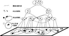
图1是本发明的系统部署结构示意图;Fig. 1 is a schematic diagram of the system deployment structure of the present invention;
图2是本发明的客户端程序结构图;Fig. 2 is a structural diagram of the client program of the present invention;
图3是本发明中网络信息搜索及位置知识发现部件详细设计结构图;Fig. 3 is a detailed design structure diagram of network information search and location knowledge discovery components in the present invention;
图4是本发明中网络信息搜索及位置知识发现的流程示意图;Fig. 4 is a schematic flow chart of network information search and location knowledge discovery in the present invention;
图5是本发明中围栏边界的判断方法示意图;Fig. 5 is a schematic diagram of a method for judging fence boundaries in the present invention;
图6是本发明中地理位置围栏聚类管理的数据结构设计图。Fig. 6 is a data structure design diagram of geographical location fence cluster management in the present invention.
具体实施方式Detailed ways
下面通过实施例,并结合附图,对本发明的技术方案作进一步具体的说明。The technical solutions of the present invention will be further specifically described below through the embodiments and in conjunction with the accompanying drawings.
实施例:Example:
首先介绍一下本发明的主要技术背景涉及以下几个方面:(1)以新一代智能手机、智能导航仪为代表的移动互联平台设备已经相当普及。新一代智能操作系统如iphone OS、Android等开发已经形成了社区化,具有良好的软、硬件开发环境支持;(2)WCDMA、CDMAZ000、TD-SCDMA在内的第三代移动通信(3G)网络系统,已逐步取代GSM系统为主的2G移动通信网络体系。同时, 4G技术规范的研究制定,能够满足位置服务中“在任何时间、任何地点通过集成终端使用任意一种网络提供的业务”的通信需求;(3)以Hadoop为代表的云计算开源系统为本发明提供了技术支撑。Firstly, the main technical background of the present invention involves the following aspects: (1) The mobile Internet platform equipment represented by a new generation of smart phones and smart navigators has become quite popular. The development of a new generation of intelligent operating systems such as iphone OS and Android has formed a community, with good support for software and hardware development environments; (2) The third generation of mobile communication (3G) networks including WCDMA, CDMAZ000, and TD-SCDMA The system has gradually replaced the 2G mobile communication network system dominated by the GSM system. At the same time, the research and development of 4G technical specifications can meet the communication requirements of "using any kind of network services provided by integrated terminals at any time and any place" in location-based services; (3) cloud computing open source systems represented by Hadoop are The invention provides technical support.
参见图1,一种基于地理时空数据的移动信息搜索及知识发现系统,包括:Referring to Figure 1, a mobile information search and knowledge discovery system based on geographical space-time data, including:
1.信息搜索服务器:采用Hadoop并行集群架构,运用网络爬虫采集工具进行并行网络信息的采集,根据网络信息爬行入口生成若干爬行任务,依照Hadoop并行集群架构划分给各处理机去获取页面,并对页面文件进行格式解析,爬行深度由系统设置;信息搜索服务器包括一个预设的爬行数据库以及一个海量数据抓取模块,海量数据抓取模块包括:1. Information search server: Adopt the Hadoop parallel cluster architecture, use the web crawler collection tool to collect parallel network information, generate several crawling tasks according to the network information crawl entrance, divide them into each processor to obtain pages according to the Hadoop parallel cluster architecture, and The format of the page file is analyzed, and the crawling depth is set by the system; the information search server includes a preset crawling database and a massive data capture module, which includes:
网页追踪单元:将用户设定的网页URL地址注入到所述爬行数据库中,实现以该网页为入口的网络信息采集,爬行由该入口地址开始深度遍历有链接的网页,爬行最大深度由用户定义;Webpage Tracking Unit: Inject the URL address of the webpage set by the user into the crawling database to realize the collection of network information with the webpage as the entry. The crawling starts from the entry address and traverses the webpages with links in depth. The maximum depth of crawling is defined by the user ;
内容获取单元:根据爬虫爬行规则根据上述网页追踪单元设定的网页进行访问网页信息,将网页内容进行下载,获取网络信息内容;Content acquisition unit: according to the crawling rules of the crawler, access the webpage information according to the webpage set by the above-mentioned webpage tracking unit, download the webpage content, and obtain the network information content;
格式解析单元:根据上述下载的网络信息进行格式解析,分析页面的HTML格式,提取页面标题、正文及相关元数据内容并将地理数据存储到一个设置在格式解析单元内的文本数据库中;Format analysis unit: perform format analysis according to the above-mentioned downloaded network information, analyze the HTML format of the page, extract the page title, text and related metadata content and store the geographical data in a text database set in the format analysis unit;
爬行数据库更新单元:若发现上述内容获取单元中的网页URL地址有更新,则将其更新的网络URL地址存储到上述爬行数据库中。Crawling database updating unit: if it is found that the URL address of the webpage in the above-mentioned content acquisition unit is updated, then store the updated network URL address in the above-mentioned crawling database.
2.知识发现服务器:根据用户定义将地理区域划分为若干位置围栏,同时接收上述信息搜索服务器采集的网络信息,通过位置知识本体对其中包含有多个位置围栏及其附属的相关概念的位置知识进行挖掘提取后给网络信息增加与该位置知识对应的位置标签,并将其以索引形式存储到知识发现服务器数据池中,该知识发现服务器根据网络信息的位置标签,将网络信息映射到各个已设置好的位置围栏中;知识发现服务器包括:2. Knowledge discovery server: Divide the geographical area into several location fences according to the user definition, and receive the network information collected by the above-mentioned information search server at the same time, and use the location knowledge ontology to analyze the location knowledge containing multiple location fences and related concepts attached thereto. After mining and extracting, add the location label corresponding to the location knowledge to the network information, and store it in the data pool of the knowledge discovery server in the form of an index. The knowledge discovery server maps the network information to each existing In the set location fence; the knowledge discovery server includes:
位置围栏管理模块:根据用户设定,将地理位置划分为若干位置围栏,并基于关联挖掘算法是确定两两位置围栏的关联度;位置围栏管理模块中进行地理位置划分的具体方法为:位置围栏由用户通过客户端或者从网络信息中提取的位置知识设置 “中心-区域式”围栏或者地理多边形围栏, 所述“中心-区域式”围栏为以一个地理坐标为圆心,以半径确定围栏范围,即记录围栏名称,围栏中心点GPS坐标,围栏半径即可;所述地理多边形围栏根据地图标注的实际道路、建筑属性进行设置,即记录围栏的各个顶点GPS坐标;该位置围栏管理模块基于关联挖掘算法是确定两两位置围栏的关联度的具体步骤如下:建立位置围栏的关联度矩阵


步骤7.1,以用户设定的一个位置围栏为叶子节点,通过分析两两围栏的出现在同一网络信息、出现在同一用户轨迹顺序、位置围栏所属机构的关联性,位置围栏所属机构包括单位性质、活跃人群、用地性质,利用基于基于关联度的聚类算法,对这些围栏集合进行层次化聚类:先将各个围栏作为围栏层次树的叶子层{},根据层次聚类的一般思路,每处理一次,得到高一层的聚类结果{

步骤7.2,在不同的社会范畴尺度上,将相近的停留点划分到同一个聚类,聚类层次树,树中的节点代表不同的围栏聚类,不同层次表示不同的地理空间尺度及其所属的社会关系范畴;随后,将不同用户的轨迹映射到这棵树的各个层次,就可以将不同的聚类连接起来,从而得到不同的图模型。Step 7.2, on different social category scales, divide similar stay points into the same cluster, cluster hierarchy tree, nodes in the tree represent different fence clusters, and different levels represent different geospatial scales and their affiliations The category of social relations; then, by mapping the trajectories of different users to each level of this tree, different clusters can be connected to obtain different graph models.
中文分词模块:所述中文分词模块内建一个通用语境下的中文辞典,然后通过词表切分并根据该中文辞典获得上述设置在格式解析单元内的文本数据库中网络信息的词汇元素;Chinese word segmentation module: the Chinese word segmentation module has a built-in Chinese dictionary under a general context, and then obtains the above-mentioned lexical elements of the network information in the text database set in the format analysis unit through vocabulary segmentation and according to the Chinese dictionary;
索引建立模块:根据所述中文分词模块获取的关键词建立以8位字节为基础的逆序索引文件格式,建立索引文件,并将索引文件进行存储;Index building module: according to the keyword that described Chinese participle module obtains, set up the reverse order index file format based on 8-bit bytes, set up index file, and store index file;
检索模块:根据位置知识本体运用布尔操作、模糊以及分组查询方式针对上述文本数据库中网络信息中的位置知识的查询,如果网络信息含有某些位置围栏相关的词汇,则将此网络信息标注该位置围栏的位置标签,将文本信息的摘要映射到位置围栏中,所述文本信息的摘要包括:标题,时间,正文前若干字,出处网址URL,所述正文前若干字根据用户设定。Retrieval module: use Boolean operations, fuzzy and group query methods to query the location knowledge in the network information in the above text database according to the location knowledge ontology. If the network information contains some words related to location fences, mark the location in the network information The location label of the fence maps the summary of the text information to the location fence. The summary of the text information includes: title, time, the first few words of the text, and the URL of the source website. The first few words of the text are set by the user.
3.信息推送服务器:将根据用户所在位置与上述知识发现服务器数据池中的位置知识本体中各个位置围栏的归属匹配结果,从所述知识发现服务器数据池中提取符合该位置的网络信息摘要,对用户实现基于位置的网络信息自适应推送;信息推送服务器包括:3. Information push server: According to the user's location and the attribution matching result of each location fence in the location knowledge ontology in the above-mentioned knowledge discovery server data pool, extract the network information summary corresponding to the location from the knowledge discovery server data pool, Realize adaptive push of network information based on location for users; information push server includes:
用户位置识别及位置围栏归属判定模块:服务器通过接收用户位置坐标信息,鉴别用户所在或附近的位置围栏; User location identification and location fence attribution determination module: the server identifies the location fence where the user is located or nearby by receiving the user location coordinate information;
信息自适应组织模块:服务器根据用户当前位置,优先组织与用户位置最相关的位置围栏中的网络信息摘要,并依据上述已经建立的位置围栏的关联度依次组织其他位置围栏中的网络信息摘要,网络信息摘要存放与消息队列中等待发出;Information self-adaptive organization module: according to the user's current location, the server prioritizes organizing the network information summaries in the location fences most relevant to the user's location, and sequentially organizes the network information summaries in other location fences according to the correlation degree of the established location fences, The network information summary is stored and waits to be sent out in the message queue;
信息推送模块:根据消息队列中的内容,将组织好的网络信息摘要发送给客户端。Information push module: According to the content in the message queue, the organized network information summary is sent to the client.
信息自适应组织模块以及信息推送模块针对k层位置围栏层次树进行信息自适应组织以及信息推送的具体步骤如下:设基于k层位置围栏层次树的信息重组及自适应表达推送算法,其中
步骤8.1:由信息自适应组织模块根据用户客户端定位结果,调用围栏归属判断算法,获得与用户当前最近的围栏
步骤8.2:将归属于
步骤8.3:如果
步骤8.4:如果
步骤8.5:重复以上过程,形成从特定叶子节点开始的全书遍历;越先进入MSG Queue消息被认为是与用户当前位置越相关的信息;Step 8.5: Repeat the above process to form a whole book traversal starting from a specific leaf node; the earlier the message enters the MSG Queue, the more relevant the information is to the user's current location;
步骤8.6:由信息推送模块将信息摘要以出栈方式推送至用户手机客户端。Step 8.6: The information push module pushes the information summary to the user's mobile phone client in the way of popping.
4.客户端:客户端程序主要基于Android和iphone系统开发。通过GPS定位芯片获得用户所在位置信息,并利用无线网络将位置信息发送给信息推送服务器,同时能接收所述信息推送服务器所推送的网络信息,并将其显示在所述客户端上;图2给出了本发明在Android上客户端模块设计图。Android运行在Linux内核上,应用程序是用 Java 编程语言编写,在一个Dalvik Virtual Machine虚拟机(VM)中运行。客户端包括4. Client: The client program is mainly developed based on Android and iPhone systems. Obtain the location information of the user through the GPS positioning chip, and use the wireless network to send the location information to the information push server, and at the same time receive the network information pushed by the information push server, and display it on the client; Figure 2 The design diagram of the client module on Android is given in the present invention. Android runs on the Linux kernel, and applications are written in the Java programming language and run in a Dalvik Virtual Machine virtual machine (VM). client includes
客户端通信模块:构建Socket用于维护客户端与服务器之间的无线网络通信;Client communication module: build Socket to maintain wireless network communication between client and server;
客户位置定位及位置信息发送模块:客户端调用移动智能手持设备中的GPS和陀螺仪接口,获取当前位置、时间、速度、高度、方位信息,组装后发送给服务器;Customer location positioning and location information sending module: the client calls the GPS and gyroscope interface in the mobile smart handheld device to obtain the current location, time, speed, altitude, and orientation information, and sends it to the server after assembly;
客户信息接收模块:收取服务器发送来的网络信息摘要,显示该摘要;Customer information receiving module: receive the summary of network information sent by the server, and display the summary;
验证模块:用于处理客户端与服务器之间用户身份认证;Authentication module: used to handle user identity authentication between the client and the server;
数据加密模块:对网络通信中所传递信息进行加密,确保信道安全及用户位置隐私。Data encryption module: Encrypt the information transmitted in network communication to ensure channel security and user location privacy.
本发明实现了一种以位置为中心的信息组织新方法。传统信息搜索及知识发现系统往往以人物或事件为中心,在信息提供的准确性上存在问题,同时不适合移动互联网环境下的移动搜索。本发明以位置为信息搜索的核心概念,满足了移动搜索的需求。同时,本发明能根据用户当前的时空环境自适应地组织网络信息并提供给用户,在信息搜索的准确性、兴趣度等方面带给用户全新的体验。The invention realizes a new method of information organization centered on location. Traditional information search and knowledge discovery systems are often centered on people or events, and there are problems in the accuracy of information provided, and they are not suitable for mobile search in the mobile Internet environment. The invention takes position as the core concept of information search, and meets the requirement of mobile search. At the same time, the present invention can adaptively organize network information according to the user's current space-time environment and provide it to the user, bringing users brand-new experience in terms of information search accuracy and interest.
中国LBS业务尚处于发展起步阶段,呈现出快速增长态势。2010年中国位置服务用户数突破瓶颈,出现井喷式增长,位置服务用户规模达到4270万,市场收入达到24.5亿元。本发明提供了位置服务的一种新模式,结合信息搜索,能够形成巨大的用户市场,带来丰富的经济和社会效益。China's LBS business is still in the initial stage of development, showing a trend of rapid growth. In 2010, the number of location-based service users in China broke through the bottleneck, and there was a blowout growth. The number of location-based service users reached 42.7 million, and the market revenue reached 2.45 billion yuan. The invention provides a new mode of position service, combined with information search, can form a huge user market and bring abundant economic and social benefits.
本文中所描述的具体实施例仅仅是对本发明精神作举例说明。本发明所属技术领域的技术人员可以对所描述的具体实施例做各种各样的修改或补充或采用类似的方式替代,但并不会偏离本发明的精神或者超越所附权利要求书所定义的范围。The specific embodiments described herein are merely illustrative of the spirit of the invention. Those skilled in the art to which the present invention belongs can make various modifications or supplements to the described specific embodiments or adopt similar methods to replace them, but they will not deviate from the spirit of the present invention or go beyond the definition of the appended claims range.
Claims (8)
Translated fromChinese


Priority Applications (1)
| Application Number | Priority Date | Filing Date | Title |
|---|---|---|---|
| CN201110199082ACN102291435B (en) | 2011-07-15 | 2011-07-15 | Mobile information searching and knowledge discovery system based on geographic spatiotemporal data |
Applications Claiming Priority (1)
| Application Number | Priority Date | Filing Date | Title |
|---|---|---|---|
| CN201110199082ACN102291435B (en) | 2011-07-15 | 2011-07-15 | Mobile information searching and knowledge discovery system based on geographic spatiotemporal data |
Publications (2)
| Publication Number | Publication Date |
|---|---|
| CN102291435A CN102291435A (en) | 2011-12-21 |
| CN102291435Btrue CN102291435B (en) | 2012-09-05 |
Family
ID=45337538
Family Applications (1)
| Application Number | Title | Priority Date | Filing Date |
|---|---|---|---|
| CN201110199082AExpired - Fee RelatedCN102291435B (en) | 2011-07-15 | 2011-07-15 | Mobile information searching and knowledge discovery system based on geographic spatiotemporal data |
Country Status (1)
| Country | Link |
|---|---|
| CN (1) | CN102291435B (en) |
Families Citing this family (64)
| Publication number | Priority date | Publication date | Assignee | Title |
|---|---|---|---|---|
| CN102646070B (en)* | 2012-02-29 | 2014-10-22 | 武汉大学 | Space-time trajectory data storage method based on area |
| CN103309903A (en)* | 2012-03-16 | 2013-09-18 | 刘龙 | Position search system and method based on cloud computing |
| CN103368984B (en)* | 2012-03-27 | 2016-06-01 | 腾讯科技(深圳)有限公司 | A kind of information sharing method and system |
| CN103428348A (en)* | 2012-05-17 | 2013-12-04 | 上海闻泰电子科技有限公司 | Method for achieving location information exchange system of mobile phone terminal |
| CN103532991B (en)* | 2012-07-03 | 2015-09-09 | 腾讯科技(深圳)有限公司 | The method of display microblog topic and mobile terminal |
| CN102789508A (en)* | 2012-07-27 | 2012-11-21 | 吴建辉 | Distributed practical condition search engine and chat system on basis of geographical position |
| CN102801796A (en)* | 2012-08-03 | 2012-11-28 | 上海华勤通讯技术有限公司 | Method for realizing information pushing of mobile terminal |
| CN103179506A (en)* | 2012-08-07 | 2013-06-26 | 深圳市金立通信设备有限公司 | System and method for realizing cellphone time-sharing push on basis of push technology |
| CN103593349B (en)* | 2012-08-14 | 2016-12-21 | 中国科学院沈阳自动化研究所 | Mobile position analysis method under sensing network environment |
| US9769604B2 (en) | 2012-08-22 | 2017-09-19 | Ebay Inc. | Passive dynamic geofencing for mobile devices |
| CN102930012A (en)* | 2012-10-31 | 2013-02-13 | 北京奇虎科技有限公司 | Client and search pilot method |
| CN102982100A (en)* | 2012-11-05 | 2013-03-20 | 上海合合信息科技发展有限公司 | Method for visiting card electronization |
| CN103841511A (en)* | 2012-11-22 | 2014-06-04 | 腾讯科技(深圳)有限公司 | Method and terminal for releasing information, and method and terminal for displaying information |
| US9432806B2 (en) | 2012-12-04 | 2016-08-30 | Ebay Inc. | Dynamic geofence based on members within |
| CN103092999B (en)* | 2013-02-22 | 2016-06-29 | 人民搜索网络股份公司 | A kind of webpage capture period modulation method and apparatus |
| CN104102638B (en)* | 2013-04-02 | 2017-06-20 | 北京百度网讯科技有限公司 | Method for pushing, system and device based on positional information |
| CN103198135A (en)* | 2013-04-12 | 2013-07-10 | 武汉大学 | Microblog registration data online acquiring method for grid division of geographic regions |
| CN103248677B (en)* | 2013-04-24 | 2016-01-27 | 深圳天源迪科信息技术股份有限公司 | The Internet behavioural analysis system and method for work thereof |
| CN104125535A (en)* | 2013-04-24 | 2014-10-29 | 吴超 | Mobile message system based on geographic position |
| CN104156364B (en)* | 2013-05-14 | 2018-06-15 | 腾讯科技(深圳)有限公司 | Map search result shows method and apparatus |
| US9191832B2 (en) | 2013-06-06 | 2015-11-17 | Apple Inc. | Category-based fence |
| CN103399965A (en)* | 2013-08-26 | 2013-11-20 | 百度在线网络技术(北京)有限公司 | Reading content recommending method, reading content recommending system and server |
| WO2015054291A1 (en) | 2013-10-09 | 2015-04-16 | Mobile Technology Corporation, LLC | Systems and methods for using spatial and temporal analysis to associate data sources with mobile devices |
| US11392987B2 (en) | 2013-10-09 | 2022-07-19 | Mobile Technology Corporation | Systems and methods for using spatial and temporal analysis to associate data sources with mobile devices |
| CN103744854A (en)* | 2013-11-15 | 2014-04-23 | 北京正图数创信息技术有限公司 | Address data matching mining platform based on big data storage and mining technology |
| US10318990B2 (en) | 2014-04-01 | 2019-06-11 | Ebay Inc. | Selecting users relevant to a geofence |
| CN104133834B (en)* | 2014-06-09 | 2018-05-04 | 合肥工业大学 | Specify the collection of region microblog data and processing method |
| CN104219245B (en)* | 2014-09-19 | 2017-05-17 | 西安电子科技大学 | System and method for location based service-orientated user privacy protection |
| CN104268243B (en)* | 2014-09-29 | 2017-11-17 | 华为技术有限公司 | A kind of position data processing method and processing device |
| CN105528384B (en)* | 2014-10-27 | 2019-03-15 | 阿里巴巴集团控股有限公司 | The method for pushing and device of information |
| CN104378378A (en)* | 2014-11-25 | 2015-02-25 | 福建三元达通讯股份有限公司 | Authentication method and system |
| CN105718465B (en)* | 2014-12-02 | 2019-04-09 | 阿里巴巴集团控股有限公司 | Geography fence generation method and device |
| CN104601713A (en)* | 2015-01-28 | 2015-05-06 | 张帅 | Undamped dynamic pushing method of time-space suppression information |
| CN106162544B (en)* | 2015-04-21 | 2019-09-03 | 阿里巴巴集团控股有限公司 | A kind of generation method and equipment of geography fence |
| CN105183770A (en)* | 2015-08-06 | 2015-12-23 | 电子科技大学 | Chinese integrated entity linking method based on graph model |
| CN106470394A (en)* | 2015-08-14 | 2017-03-01 | 江贻芳 | A kind of enclosure wall structure based on indoor and outdoor integration and application process |
| CN105117455A (en)* | 2015-08-18 | 2015-12-02 | 北京奇虎科技有限公司 | Along-the-road target image search method, terminal and system |
| US10120948B2 (en)* | 2015-10-13 | 2018-11-06 | Google Llc | Providing notifications based on geofencing search results |
| KR101732981B1 (en)* | 2015-10-29 | 2017-05-08 | 삼성에스디에스 주식회사 | System and method for analyzing personalized characteristics |
| CN105510876B (en)* | 2015-12-25 | 2017-12-15 | 武汉大学 | A kind of indoor distance-measuring and positioning method based on propagation properties |
| CN105677733A (en)* | 2015-12-29 | 2016-06-15 | 深圳市鼎芯无限科技有限公司 | Method and apparatus for finding GPS periphery |
| US10064006B2 (en)* | 2016-08-26 | 2018-08-28 | Microsoft Technology Licensing, Llc | Location based access control for artificial conversational entities |
| CN107979616A (en)* | 2016-10-21 | 2018-05-01 | 浙江银泰电子商务有限公司 | Information-pushing method and information transmission system |
| CN106790690B (en)* | 2017-02-20 | 2020-07-07 | 中国地质大学(武汉) | Cross-floor message pushing method and device |
| CN107147943A (en)* | 2017-05-05 | 2017-09-08 | 中广热点云科技有限公司 | Method for sending broadcasted content in time |
| CN107135043B (en)* | 2017-05-05 | 2019-09-27 | 中广热点云科技有限公司 | Public emergency broadcast system |
| CN109257193A (en)* | 2017-07-11 | 2019-01-22 | 中国移动通信有限公司研究院 | Edge cache management method, personal cloud system and computer readable storage medium |
| CN107943848B (en)* | 2017-11-02 | 2019-12-10 | 武汉大学 | A Ubiquitous Spatiotemporal Information Association and Aggregation Method |
| CN110110196A (en)* | 2017-12-25 | 2019-08-09 | 北京京东尚科信息技术有限公司 | A kind of information push method and device |
| CN110012430A (en)* | 2018-01-05 | 2019-07-12 | 触信(厦门)智能科技有限公司 | A kind of intelligent information acquisition methods |
| CN108257052B (en)* | 2018-01-16 | 2022-04-22 | 中南大学 | An online student knowledge assessment method and system |
| CN110677810B (en)* | 2018-07-03 | 2021-04-02 | 百度在线网络技术(北京)有限公司 | Method and apparatus for generating geo-fences |
| CN113626386A (en)* | 2018-10-22 | 2021-11-09 | 王梅 | Method and system for determining data state of target mobile terminal in mobile internet |
| CN109857950A (en)* | 2019-02-21 | 2019-06-07 | 孔瑜佳 | A kind of geologic information obtains, method for pushing and device |
| CN109815412A (en)* | 2019-03-03 | 2019-05-28 | 山东省地质测绘院 | A kind of geologic information search methods of exhibiting and device |
| CN110460643A (en)* | 2019-07-16 | 2019-11-15 | 盐城师范学院 | An Intelligent Digital Content Screening System |
| CN111651535B (en)* | 2019-09-24 | 2021-08-17 | 北京嘀嘀无限科技发展有限公司 | Information query processing method and device, electronic equipment and readable storage medium |
| US10687174B1 (en) | 2019-09-25 | 2020-06-16 | Mobile Technology, LLC | Systems and methods for using spatial and temporal analysis to associate data sources with mobile devices |
| CN110968798B (en)* | 2019-10-25 | 2023-11-24 | 贝壳找房(北京)科技有限公司 | House source display method and device, readable storage medium and processor |
| CN110995834B (en)* | 2019-12-02 | 2022-10-21 | 北京应用科学技术研究院 | Social network trajectory following method and system |
| CN111339091B (en)* | 2020-02-23 | 2023-05-26 | 兰州理工大学 | Differential privacy dividing and publishing method for position big data based on non-uniform quadtree structure |
| CN112233292B (en)* | 2020-09-25 | 2022-06-21 | 武汉绿色网络信息服务有限责任公司 | Access control method and access control device based on acquaintances visiting |
| CN116668951B (en)* | 2022-10-26 | 2024-04-23 | 荣耀终端有限公司 | Method for generating geofence, electronic equipment and storage medium |
| CN117033818B (en)* | 2023-10-10 | 2023-12-05 | 一站发展(北京)云计算科技有限公司 | Peripheral information processing method and system |
Citations (3)
| Publication number | Priority date | Publication date | Assignee | Title |
|---|---|---|---|---|
| CN101052181A (en)* | 2007-05-22 | 2007-10-10 | 中国移动通信集团浙江有限公司 | Wireless searching system and its wireless searching method |
| CN101409748A (en)* | 2008-07-08 | 2009-04-15 | 浙江大学 | System and method for collecting, indexing, subscribing and publishing mobile terminal information |
| CN101477556A (en)* | 2009-01-22 | 2009-07-08 | 苏州智讯科技有限公司 | Method for discovering hot sport in internet mass information |
- 2011
- 2011-07-15CNCN201110199082Apatent/CN102291435B/ennot_activeExpired - Fee Related
Patent Citations (3)
| Publication number | Priority date | Publication date | Assignee | Title |
|---|---|---|---|---|
| CN101052181A (en)* | 2007-05-22 | 2007-10-10 | 中国移动通信集团浙江有限公司 | Wireless searching system and its wireless searching method |
| CN101409748A (en)* | 2008-07-08 | 2009-04-15 | 浙江大学 | System and method for collecting, indexing, subscribing and publishing mobile terminal information |
| CN101477556A (en)* | 2009-01-22 | 2009-07-08 | 苏州智讯科技有限公司 | Method for discovering hot sport in internet mass information |
Also Published As
| Publication number | Publication date |
|---|---|
| CN102291435A (en) | 2011-12-21 |
Similar Documents
| Publication | Publication Date | Title |
|---|---|---|
| CN102291435B (en) | Mobile information searching and knowledge discovery system based on geographic spatiotemporal data | |
| CN110147437B (en) | Knowledge graph-based searching method and device | |
| CN105718579B (en) | A kind of information-pushing method excavated based on internet log and User Activity identifies | |
| CN110399568B (en) | Information searching method, device, terminal and storage medium | |
| CN101647020A (en) | Searching structured geographic data | |
| CN101842788A (en) | Method, apparatus and computer program product for performing a visual search using grid-based feature organization | |
| CN103390000B (en) | A kind of web search method and web page search system | |
| CN106649656A (en) | Spatial-temporal trajectory big data storage method for database | |
| CN102890713A (en) | Music recommending method based on current geographical position and physical environment of user | |
| CN101916288B (en) | A mobile communication user search request response system and processing method thereof | |
| CN110377751A (en) | Courseware intelligent generation method, device, computer equipment and storage medium | |
| Zhao et al. | Topic-centric and semantic-aware retrieval system for internet of things | |
| CN104615734B (en) | A kind of community management service big data processing system and its processing method | |
| CN106649498A (en) | Network public opinion analysis system based on crawler and text clustering analysis | |
| CN115510116A (en) | Data directory construction method, device, medium and equipment | |
| Li | [Retracted] Internet Tourism Resource Retrieval Using PageRank Search Ranking Algorithm | |
| CN104298669A (en) | Person geographic information mining model based on social network | |
| Rehman et al. | Building socially-enabled event-enriched maps | |
| CN112035723A (en) | Resource library determination method and device, storage medium and electronic device | |
| CN118861211A (en) | A multimodal data retrieval method and device based on metric index | |
| CN117271577B (en) | Keyword retrieval method based on intelligent analysis | |
| CN104516948A (en) | Position information extracting method and device based on mass data | |
| JP4651975B2 (en) | Information search system, information search device, information search support device, information search program, and information search support program | |
| Wang et al. | Research on lda model algorithm of news-oriented web crawler | |
| CN116821692A (en) | Method, device and storage medium for constructing descriptive text and space scene sample set |
Legal Events
| Date | Code | Title | Description |
|---|---|---|---|
| C06 | Publication | ||
| PB01 | Publication | ||
| C10 | Entry into substantive examination | ||
| SE01 | Entry into force of request for substantive examination | ||
| C14 | Grant of patent or utility model | ||
| GR01 | Patent grant | ||
| ASS | Succession or assignment of patent right | Owner name:DEQING ZHIYU INFORMATION TECHNOLOGY CO., LTD. Free format text:FORMER OWNER: WUHAN UNIVERSITY Effective date:20150108 | |
| C41 | Transfer of patent application or patent right or utility model | ||
| COR | Change of bibliographic data | Free format text:CORRECT: ADDRESS; FROM: 430072 WUHAN, HUBEI PROVINCE TO: 313299 HUZHOU, ZHEJIANG PROVINCE | |
| TR01 | Transfer of patent right | Effective date of registration:20150108 Address after:313299 Zhejiang city of Huzhou province Deqing County Zhiyuan Wukang Road No. 425 Patentee after:DEQING ZHIYU INFORMATION TECHNOLOGY CO.,LTD. Address before:430072 Hubei Province, Wuhan city Wuchang District of Wuhan University Luojiashan Patentee before:Wuhan University | |
| C41 | Transfer of patent application or patent right or utility model | ||
| TR01 | Transfer of patent right | Effective date of registration:20161031 Address after:430000 Hubei city of Wuhan province Optics Valley East Lake New Technology Development Zone, Road No. 58 South Park two No. 2 Fuxing Medicine Building 24 room 6 Patentee after:WUHAN LIUDIANZHENG BEIDOU TECHNOLOGY CO.,LTD. Address before:313299 Zhejiang city of Huzhou province Deqing County Zhiyuan Wukang Road No. 425 Patentee before:DEQING ZHIYU INFORMATION TECHNOLOGY CO.,LTD. | |
| CF01 | Termination of patent right due to non-payment of annual fee | Granted publication date:20120905 | |
| CF01 | Termination of patent right due to non-payment of annual fee |