CN102175245A - Underwater vehicle path planning method based on ocean current historical statistic information - Google Patents
Underwater vehicle path planning method based on ocean current historical statistic informationDownload PDFInfo
- Publication number
- CN102175245A CN102175245ACN 201110031277CN201110031277ACN102175245ACN 102175245 ACN102175245 ACN 102175245ACN 201110031277CN201110031277CN 201110031277CN 201110031277 ACN201110031277 ACN 201110031277ACN 102175245 ACN102175245 ACN 102175245A
- Authority
- CN
- China
- Prior art keywords
- path
- current
- value
- submersible
- particle
- Prior art date
- Legal status (The legal status is an assumption and is not a legal conclusion. Google has not performed a legal analysis and makes no representation as to the accuracy of the status listed.)
- Granted
Links
- 238000000034methodMethods0.000titleclaimsabstractdescription27
- 239000002245particleSubstances0.000claimsabstractdescription53
- 238000004422calculation algorithmMethods0.000claimsabstractdescription19
- 238000011156evaluationMethods0.000claimsabstractdescription16
- 238000005457optimizationMethods0.000claimsabstractdescription16
- 230000006870functionEffects0.000claimsabstractdescription14
- XLYOFNOQVPJJNP-UHFFFAOYSA-NwaterSubstancesOXLYOFNOQVPJJNP-UHFFFAOYSA-N0.000claimsabstractdescription7
- 230000007613environmental effectEffects0.000claimsabstractdescription4
- 238000005265energy consumptionMethods0.000claimsdescription21
- 230000001133accelerationEffects0.000claimsdescription4
- 230000003068static effectEffects0.000claimsdescription2
- 238000013461designMethods0.000abstractdescription6
- 238000010845search algorithmMethods0.000abstract1
- 238000011160researchMethods0.000description5
- 230000008859changeEffects0.000description3
- 238000005516engineering processMethods0.000description3
- 230000008901benefitEffects0.000description2
- 239000000446fuelSubstances0.000description2
- 230000006872improvementEffects0.000description2
- 230000008569processEffects0.000description2
- 230000002411adverseEffects0.000description1
- 238000004364calculation methodMethods0.000description1
- 230000001149cognitive effectEffects0.000description1
- 230000002860competitive effectEffects0.000description1
- 230000007547defectEffects0.000description1
- 238000011161developmentMethods0.000description1
- 230000000694effectsEffects0.000description1
- 230000002068genetic effectEffects0.000description1
- 238000003672processing methodMethods0.000description1
- 238000013441quality evaluationMethods0.000description1
- 238000004088simulationMethods0.000description1
Images

Landscapes
- Navigation (AREA)
Abstract
Translated fromChinese
Description
Translated fromChinese技术领域technical field
本发明属于水下潜器路径规划领域,尤其是一种基于海流历史统计信息的的水下潜器路径规划方法。The invention belongs to the field of underwater submersible path planning, in particular to an underwater submersible path planning method based on historical statistical information of ocean currents.
背景技术Background technique
路径规划问题是水下潜器智能控制的关键技术之一。随着人们对海洋资源的日趋关注,水下潜器在海洋开发、军事侦察及援潜救生中发挥着越来越重要的作用,人们对水下潜器实现智能控制和自主导航的要求和期望也越来越高,路径规划技术在一定程度上直接关系到水下潜器智能水平的高低。由于水下潜器经常工作在大范围开放的三维空间环境中,受到各种海洋环境要素的影响。这种情况下路径规划方法已经不仅仅是避障问题,还要充分考虑各种海洋要素对潜器航行的影响。Path planning is one of the key technologies of intelligent control of underwater vehicles. As people pay more and more attention to marine resources, underwater vehicles play an increasingly important role in ocean development, military reconnaissance and submarine rescue. People's requirements and expectations for intelligent control and autonomous navigation of underwater vehicles It is also getting higher and higher, and the path planning technology is directly related to the intelligence level of the underwater submersible to a certain extent. Since underwater submersibles often work in a large-scale open three-dimensional space environment, they are affected by various marine environmental elements. In this case, the path planning method is not only a problem of obstacle avoidance, but also needs to fully consider the influence of various ocean elements on the navigation of the submersible.
目前针对路径规划的研究主要集中在路径规划的方法上,如路径优化方法、障碍物规避方法等。例如申请号为200910100613.1的专利申请一种基于粒子群优化算法的移动机器人路径规划方法,该专利对机器人路径利用粒子群优化算法进行规划;最后对规划的路径进行深度优先搜索。申请号为201010123511.4的专利提出一种基于双群协同竞争粒子群和Ferguson样条的机器人路径规划方法,该方法主要解决现有技术中存在的规划路径平滑性差且收敛速度缓慢的问题。这些方法在实验室仿真下已经取得不错的效果,但是离实际应用还有很大的距离,主要原因之一就是没有考虑实际的航行环境或者考虑较少。由于海流的流幅多数比较宽,流速也比较大,对航海会产生比较明显的影响。潜器在有海流存在的海域航行,必须及时修正航向、航速,否则会改变计划航线、加长航程,甚至会出现航海事故或影响任务的完成。同时潜器在航行过程中如果能充分利用海流的影响,避开逆流并沿着顺流航行则能大大节省燃料。因此在路径规划中如果充分考虑海流的影响,不仅能够保证规划出安全可靠的航行路线,而且能够节省燃料。目前国内外已经有一些学者开始海流影响下的路径规划技术研究。例如徐玉如,姚耀中在《考虑海流影响的水下机器人全局路径规划研究》一文中将海流因素作为遗传算法的评价因子,在路径规划的层面上考虑海流的影响。毛宇峰,庞永杰在《改进粒子群在水下机器人路径规划中的应用》一文中设计了综合路径长度、海流和转向费用的适应度函数,使算法很好地适应海流的变化,很大程度减小了海流对水下机器人能量消耗和控制的不利影响。但是上述两篇论文在路径规划中采用的海流均是由流函数生成的,与实际海流存在较大差别。利用这种海流数据进行路径规划虽然在一定程度上考虑了海流的影响,但是由于这种海流与实际海流存在较大的差距,因此生成的路径与实际航线偏差较大。海流的流动具有相对稳定性,在较长时间内流动方向、速率和流动路径大致相似。海流历史统计数据是完全根据实测资料进行统计的结果,包括最大、最小、平均值等多个统计项目结果,因此在没有实测信息的情况下,可以利用历史观测统计资料来近似表示当前流场。At present, the research on path planning mainly focuses on the methods of path planning, such as path optimization method, obstacle avoidance method and so on. For example, the patent application number 200910100613.1 applies for a mobile robot path planning method based on particle swarm optimization algorithm. The patent uses particle swarm optimization algorithm to plan the robot path; finally, depth-first search is performed on the planned path. The patent application number 201010123511.4 proposes a robot path planning method based on double-swarm cooperative competitive particle swarm and Ferguson splines. This method mainly solves the problems of poor smoothness and slow convergence speed of the planned path in the prior art. These methods have achieved good results under laboratory simulation, but there is still a long way to go from practical application. One of the main reasons is that the actual navigation environment is not considered or considered less. Since most of the ocean currents have relatively wide amplitude and relatively high velocity, they will have a more obvious impact on navigation. When a submersible sails in a sea area with currents, it must correct its course and speed in time, otherwise it will change the planned route, extend the voyage, or even cause a navigation accident or affect the completion of the mission. At the same time, if the submersible can make full use of the influence of the ocean current during navigation, avoid the countercurrent and sail along the downstream, it can greatly save fuel. Therefore, if the influence of ocean currents is fully considered in path planning, not only can a safe and reliable navigation route be planned, but also fuel can be saved. At present, some scholars at home and abroad have begun to study path planning technology under the influence of ocean currents. For example, Xu Yuru and Yao Yaozhong used the current factor as the evaluation factor of the genetic algorithm in the article "Research on the Global Path Planning of Underwater Robots Considering the Influence of Ocean Currents", and considered the influence of ocean currents at the level of path planning. Mao Yufeng and Pang Yongjie designed the fitness function of comprehensive path length, ocean current and turning cost in the article "Application of Improved Particle Swarm in Path Planning of Underwater Robot", so that the algorithm can well adapt to the change of ocean current and greatly reduce the The adverse effects of ocean currents on the energy consumption and control of underwater robots are investigated. However, the ocean currents used in the path planning of the above two papers are generated by flow functions, which are quite different from the actual ocean currents. Although the influence of ocean currents is considered to a certain extent by using this ocean current data for path planning, there is a large gap between this ocean current and the actual ocean current, so the generated path deviates greatly from the actual route. The flow of ocean currents is relatively stable, and the flow direction, velocity and flow path are roughly similar over a long period of time. The historical statistical data of ocean currents are the statistical results based entirely on the measured data, including the results of multiple statistical items such as maximum, minimum, and average values. Therefore, in the absence of measured information, historical observation statistics can be used to approximate the current flow field.
发明内容Contents of the invention
本发明的目的是为了解决传统路径规划中考虑海流因素较少的缺陷,提出了一种基于海流历史统计信息的水下潜器路径规划方法。本发明利用海流历史统计数据库生成接近真实值的海流场,在路径规划中充分考虑了海流的影响,使规划出的路径更接近水下潜器实际航行路线。The purpose of the present invention is to solve the defect of less consideration of ocean current factors in traditional path planning, and proposes an underwater submersible path planning method based on historical statistical information of ocean currents. The invention utilizes the ocean current history statistical database to generate an ocean current field close to the real value, fully considers the influence of the ocean current in path planning, and makes the planned path closer to the actual navigation route of the underwater submersible.
本发明的目的是利用海流历史统计数据库生成海流场,提供一种充分考虑海流影响的路径规划的方法。其特征在于,该方法包含以下要点:The purpose of the present invention is to use the ocean current history statistical database to generate the ocean current field, and provide a method for path planning that fully considers the influence of the ocean current. It is characterized in that the method includes the following key points:
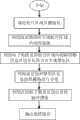
步骤1.确定航行区域,将航行区域栅格化;Step 1. Determine the navigation area and rasterize the navigation area;
步骤2.利用海流历史统计数据库生成航行区域内的海流场;Step 2. Generate the ocean current field in the navigation area by using the ocean current history statistics database;
步骤3.利用电子海图作为环境场,将航行区域内的障碍物、岛屿、浅水区进行简化合并,生成禁航区;Step 3. Use the electronic chart as the environmental field to simplify and merge obstacles, islands, and shallow water areas in the navigation area to generate no-navigation areas;
步骤4.将海流信息和禁航区信息按照栅格进行存储;Step 4. Store current information and no-navigation area information according to the grid;
步骤5.构造路径评价函数;Step 5. Constructing a path evaluation function;
步骤6.利用粒子群算法进行最优路径搜索;Step 6. Utilize particle swarm optimization algorithm to search for optimal path;
步骤7.输出路径,路径规划结束。Step 7. Output the path, and the path planning ends.
本发明的优点在于:The advantages of the present invention are:
本发明利用海流历史统计数据库生成接近真实值的海流场,在充分考虑海流影响的情况下,设计了考虑航行安全性、经济性、光滑性相结合的路径评价函数,利用改进粒子群优化算法作为优化算法进行水下潜器全局路径规划,以规划出更接近实际航行路线的潜器航行路径。The present invention uses the ocean current history statistical database to generate an ocean current field close to the real value, and in the case of fully considering the impact of the ocean current, designs a path evaluation function that combines navigation safety, economy, and smoothness, and uses the improved particle swarm optimization algorithm As an optimization algorithm, the global path planning of the underwater submersible is carried out to plan a submersible navigation path closer to the actual navigation route.
附图说明Description of drawings
图1为本发明所述水下潜器路径规划流程图。Fig. 1 is a flow chart of path planning for an underwater submersible according to the present invention.
图2为本发明说书改进粒子群优化算法流程图。Fig. 2 is a flow chart of the improved particle swarm optimization algorithm of the present invention.
具体实施方式Detailed ways
下面将结合附图和实施例对本发明作进一步的详细说明。The present invention will be further described in detail with reference to the accompanying drawings and embodiments.
本发明是一种基于海流历史统计信息的水下潜器路径规划方法,该包括环境建模、海流场生成、路径评价函数设计、改进粒子群算法设计等关键内容,具体流程如图1所示,包括以下:The present invention is a path planning method for underwater submersibles based on historical statistical information of ocean currents, which includes key contents such as environment modeling, ocean current field generation, path evaluation function design, and improved particle swarm algorithm design. The specific process is shown in Figure 1 display, including the following:
步骤1.确定航行区域,将航行区域栅格化。Step 1. Determine the navigation area and rasterize the navigation area.
航行区域为以路径起始点和终止点连线为对角线的矩形区域。沿经度和纬度方向分别以10′为单位进行等间隔划分,生成大小为10′X10′的栅格区域。The navigation area is a rectangular area whose diagonal is the line connecting the starting point and the ending point of the path. Along the longitude and latitude directions, the division is performed at equal intervals in units of 10' to generate a grid area with a size of 10'X10'.
步骤2.利用海流历史统计数据库生成航行区域内的海流场。Step 2. Use the ocean current history statistics database to generate the ocean current field in the navigation area.
海流历史统计数据库存储有海流的12个月份历史统计信息,海流信息是经过累年月平均统计得到,具有一定的权威性和很大的参考价值。海流历史统计数据库由25个表组成,分别为月份表、12个月份的海流统计信息北偏量表和12月份的东偏量表。海流信息以网格的形式分布,经纬度的分辨率均为10′,每一个网格的海流以东偏量u和北偏量v来表示,分别存放在海流数据库中的东偏量表和北偏量表中。已知某位置海流的东偏量u和北偏v,则该处的流向θ和流速
航行区域内海流场的生成方法如下:首先连接海流历史统计数据库,数据库连接成功后在月份表中查询当前日期对应的数据表名。遍历步骤1中航行区域划分的栅格,计算每一个栅格的经纬度值,然后根据数据表名在相应的东偏量表和北偏量表中查询当前经纬度对应的海流的北偏量和东偏量值,并把该值存在海流结构体Struct oceanCurrent中。海流结构体的具体定义如下:The generation method of the ocean current field in the navigation area is as follows: first connect to the ocean current history statistics database, and after the database connection is successful, query the data table name corresponding to the current date in the month table. Traverse the grid divided by navigation area in step 1, calculate the latitude and longitude value of each grid, and then query the north deviation and easting of the ocean current corresponding to the current latitude and longitude in the corresponding east deviation table and north deviation table according to the data table name Offset value, and store this value in the ocean current structure Struct oceanCurrent. The specific definition of ocean current structure is as follows:
Struct oceanCurrentStruct oceanCurrent
{{
float oceancurrentU;float oceancurrentU;
float oceancurrentV;float oceancurrentV;
}}
其中,oceancurrentU为该栅格点内的海流东偏量,oceancurrentV为该栅格点内的海流北偏量。Among them, oceancurrentU is the easting offset of the ocean current in the grid point, and oceancurrentV is the north offset of the ocean current in the grid point.
步骤3.利用电子海图作为环境场,将航行区域内的障碍物、岛屿、浅水区进行简化合并,生成禁航区。Step 3. Use the electronic chart as the environment field to simplify and combine the obstacles, islands, and shallow water areas in the navigation area to generate a no-navigation area.
水下潜器航行中的障碍物主要有岛屿、岛礁、浅水区、沉船。电子海图是水下潜器的“眼睛”,因此潜器航线规划可以建立在准确的海图信息基础上。利用shapefile格式电子海图信息作为静态环境场,将环境中的障碍物、浅水区、岛屿以多边形形式进行表达。多边形围成的区域为禁航区,路径不能通过,其他区域为可行域,路径可以通过。具体处理方法及定义如下:The obstacles in the navigation of underwater submersibles mainly include islands, reefs, shallow water areas, and shipwrecks. The electronic chart is the "eye" of the underwater vehicle, so the route planning of the submersible can be based on accurate chart information. Using the electronic chart information in shapefile format as the static environment field, the obstacles, shallow water areas, and islands in the environment are expressed in the form of polygons. The area surrounded by polygons is a no-fly area, and the path cannot pass through it. Other areas are feasible areas, and the path can pass through. The specific processing methods and definitions are as follows:
安全区:该区域中潜器航行没有任何危险Safe zone: There is no danger for the submersible to sail in this zone
禁航区:该区域存在不利于潜器安全航行的要素,会危及潜器航行安全。Prohibited navigation area: There are elements in this area that are not conducive to the safe navigation of submersibles and will endanger the navigation safety of submersibles.
步骤4.将海流信息和禁航区信息按照栅格进行存储。Step 4. Store current information and no-navigation area information in grids.
对于步骤1中划分的每一个栅格,定义数据结构struct PosInfor来存储该栅格的位置信息、海流信息以及是否可航。PosInfor的具体定义如下:For each grid divided in step 1, define the data structure struct PosInfor to store the grid's position information, current information and whether it is navigable. The specific definition of PosInfor is as follows:
struct PosInforstruct PosInfor
{{
float lon;float lon;
float 1at;float 1at;
float oceancurrentU;float oceancurrentU;
float oceancurrentV;float oceancurrentV;
bool bNoPassing;bool bNoPassing;
}}
其中lat为栅格点的纬度,lon为栅格点的经度,oceancurrentU为栅格点内的海流东偏量,oceancurrentV为栅格点内的海流北偏量,bNoPassing表示该栅格是否可航,1表示不可航,0表示可航。Among them, lat is the latitude of the grid point, lon is the longitude of the grid point, oceancurrentU is the east offset of the ocean current in the grid point, oceancurrentV is the north offset of the ocean current in the grid point, bNoPassing indicates whether the grid is navigable, 1 means unnavigable, 0 means navigable.
步骤5.构造路径评价函数;Step 5. Constructing a path evaluation function;
在现有的水下潜器路径规划中,要么是时间固定的能量消耗最优路径研究,要么是不考虑能量消耗的时间最优路径研究。而在实际的航行中,能量消耗、航行时间均需要考虑。另外对于具备特定任务的水下潜器来说,航行的隐蔽性和安全性也是需要考虑的因素之一。因此本发明设计了一个综合考虑能量消耗、路径长度、安全性、光滑度等四个评价指标的路径性能评价函数,具体包括以下几个步骤:In the existing underwater vehicle path planning, it is either the time-fixed energy consumption optimal path research, or the time optimal path research without considering the energy consumption. In actual voyage, both energy consumption and voyage time need to be considered. In addition, for underwater submersibles with specific tasks, the concealment and safety of navigation are also one of the factors that need to be considered. Therefore, the present invention designs a path performance evaluation function that comprehensively considers four evaluation indicators such as energy consumption, path length, safety, and smoothness, and specifically includes the following steps:
(1)能量消耗(1) Energy consumption
潜器航行过程中的能量消耗主要由两部分组成。一部分用来克服惯性的加速力Fa,另一部分用来克服牵引潜器运动的牵引力Fd。The energy consumption during the voyage of the submersible is mainly composed of two parts. One part is used to overcome the acceleration force Fa of inertia, and the other part is used to overcome the traction force Fd of pulling the submersible.
Fa(t)=waVr(t) (5)Fa (t) = wa Vr (t) (5)
Fd(t)=wdV2r(t) (6)Fd (t) = wd V2r (t) (6)
其中,Eenergy表示潜器克服惯性力和牵引力需要消耗的能量,Vr(t)为相对速度,即马达需要提供的速度,

每条航路段又可以划分成m条子航路段,划分时要确保每条子航路段上的海流值的最大值与最小值偏差不大于航路段上海流平均值的十分之一。Each route segment can be divided into m sub-route segments. When dividing, it is necessary to ensure that the deviation between the maximum value and the minimum value of the sea current value on each sub-route segment is not greater than one tenth of the average sea current value of the route segment.
其中Esum为整条航路等能量消耗,Ei为第i个航路段内的能量消耗,Eij为第i个航路段内的第j个子航路段的能量消耗,Δtj为第j个子航路段花费的时间,wa,wd为调和常数。Vr,j为第j个子航路段内的潜器相对速度。Where Esum is the energy consumption of the whole route, Ei is the energy consumption in the i-th route segment, Eij is the energy consumption in the j-th sub-route segment in the i-th route segment, Δtj is the j-th sub-route The time spent in the segment, wa , wd are harmonic constants. Vr, j is the relative velocity of the submersible in the jth sub-segment.
(2)路径长度(2) Path length
对于由n个节点的路径来说,共有n-1条路径段,路径长度就是将这些路径段的长度相加,即:For a path consisting of n nodes, there are n-1 path segments in total, and the path length is the sum of the lengths of these path segments, namely:
其中,Elength表示整条航路的长度,ΔLi为第i条航路段的长度,xi,yi为第i个路径点的坐标,xi-1,yi-1为第i-1个路径点的坐标,1≤i≤n。Among them, Elength represents the length of the entire route, ΔLi is the length of the i-th route segment, xi , yi are the coordinates of the i-th waypoint, xi-1 , yi-1 are the i-1th The coordinates of path points, 1≤i≤n.
(3)安全性(3) Security
为了保证潜器航行的安全性,规划航路禁航区等必须保持一定的安全距离。规划航线不穿过禁航区并且与禁航区的距离大于安全距离时该航线是安全的。取距离航线最近的禁航区与航线的距离Lmin作为评价标准,Lmin越大则航线越安全。In order to ensure the safety of submersible navigation, a certain safe distance must be kept in the restricted area of the planned route. The route is safe when the planned route does not pass through the no-fly area and the distance from the no-fly area is greater than the safety distance. The distance Lmin between the nearest no-flight zone and the route is taken as the evaluation standard, and the larger the Lmin is, the safer the route is.
其中,Esafty表示安全代价值,Lmin为距离航线最近的禁航区或者障碍区与航线的距离,Lsafe为潜器与禁航区应该保持的最小安全距离,由潜器的尺寸确定,取潜器长度的6-15倍,本发明中取10倍,K为一个常数,它的取值为900Lsafe至1100Lsafe,本发明中取1000Lsafe。Among them, Esafety represents the safety cost value, Lmin is the distance between the nearest no-navigation area or obstacle area and the route, and Lsafe is the minimum safe distance between the submersible and the no-navigation area, which is determined by the size of the submersible. Get 6-15 times of submersible length, get 10 times in the present invention, K is a constant, its value is 900Lsafe to 1100Lsafe , gets 1000Lsafe in the present invention.
(4)光滑性(4) smoothness
光滑度是指路径中每一个路径点处路径偏转角度的大小。路径从出发点到目的点所偏转的总角度越小,路径越平滑,潜器转向的角度越小,路径质量越高。因此设计路径平滑度应等于路径所有路径点的偏转角度之和,即:Smoothness refers to the magnitude of the path deflection angle at each path point in the path. The smaller the total deflection angle of the path from the starting point to the destination point, the smoother the path is, and the smaller the turning angle of the submersible is, the higher the path quality is. Therefore, the smoothness of the design path should be equal to the sum of the deflection angles of all path points on the path, namely:
其中,Esmooth表示光滑度代价值,θi表示第i段路径相对于第i-1段路径的偏转角度。Among them, Esmooth represents the cost value of smoothness, and θi represents the deflection angle of the i-th path relative to the i-1-th path.
在上述四个评价指标中,能量消耗越大、路径越长、距离航线最近的禁航区到航线的距离Lmin越小、偏转角之和越大的路径为较差的路径,因此衡量路径优劣的评价函数可以设计成:Among the above four evaluation indicators, the path with greater energy consumption, longer path, smaller distance Lmin from the no-flight zone closest to the route to the route, and larger sum of deflection angles is a poor path. The quality evaluation function can be designed as:
E(p)=wenergyEenergy+wsaftyEsafty+wlengthElength+wsmoothEmooth (13)E(p)=wenergy Eenergy +wsafety Esafety +wlength Elength +wsmooth Esmooth (13)
其中wenergy、wsafty、wlength、wsmooth为权系数,具体取值由对路径的要求确定。当能量消耗为主要考虑对象时wenergy的值要大于其他三个系数;当安全性为主要考虑对象时wsafty的值要大于其他三个系数;当路径长度为主要考虑对象时wlength的值要大于其他三个系数;当路径光滑度为主要考虑对象时wsmooth的值要大于其他三个系数。E(p)越小,路径越好。Among them, wenergy , wsafety , wlength , and wsmooth are weight coefficients, and the specific values are determined by the requirements of the path. When energy consumption is the main consideration, the value of wenergy is greater than the other three coefficients; when safety is the main consideration, the value of wsafety is greater than the other three coefficients; when the path length is the main consideration, the value of wlength It should be greater than the other three coefficients; when the path smoothness is the main consideration, the value of wsmooth should be greater than the other three coefficients. The smaller E(p) is, the better the path is.
步骤6.利用粒子群算法进行最优路径搜索;Step 6. Utilize particle swarm optimization algorithm to search for optimal path;
PSO的优点在于简单同时又有深刻的智能背景,既适合科学研究,又特别适合工程应用。PSO算法的主要缺点是易陷入局部极小点。近几年来已提出了多种PSO改进,其中把PSO中的参数设置为时变参数是一种新的参数调整策略。用对惯性系数和学习因子的改进来提高粒子群算法的寻优能力。改进的目的是提高粒子在早期搜索过程中的全局搜索能力,并最终促使粒子在搜索的最终阶段收敛于全局最优解。本专利采用时变参数粒子群算法进行最优路径搜索。The advantage of PSO is that it is simple and has profound intelligence background at the same time. It is suitable for scientific research and especially for engineering applications. The main disadvantage of the PSO algorithm is that it is easy to fall into a local minimum point. A variety of PSO improvements have been proposed in recent years, among which setting the parameters in PSO as time-varying parameters is a new parameter adjustment strategy. Improve the optimization ability of particle swarm optimization algorithm by improving the inertia coefficient and learning factor. The purpose of the improvement is to improve the global search ability of the particles in the early search process, and finally promote the particles to converge to the global optimal solution in the final stage of the search. This patent uses time-varying parameter particle swarm algorithm to search for the optimal path.
步骤6.1.确定粒子群的参数、最大迭代次数、种群大小,完成粒子群初始化。Step 6.1. Determine the parameters of the particle swarm, the maximum number of iterations, and the population size, and complete the initialization of the particle swarm.
步骤6.2.根据步骤5确定的路径评价函数计算每个粒子的适应值。Step 6.2. Calculate the fitness value of each particle according to the path evaluation function determined in step 5.
步骤6.3.更新每个粒子的最优适应值和整个群体的最优适应值。Step 6.3. Update the optimal fitness value of each particle and the optimal fitness value of the whole population.
如果粒子当前位置适应度小于其个体最优位置的适应度值,则以当前位置适应度值作为该粒子的最优适应。如果所有个体最优位置中出现适应度值低于整个群体的最优适应值,则以所有个体最优位置中出现的适应度值代替整个群体的最优适应度值。If the particle's current position fitness is less than the fitness value of its individual optimal position, the current position fitness value is taken as the particle's optimal fitness. If the fitness value in the optimal position of all individuals is lower than the optimal fitness value of the entire group, then the optimal fitness value of the entire group is replaced by the fitness value in the optimal position of all individuals.
步骤6.4.判断当前迭代次数是否达到步骤6.1设定的最大迭代次数,如何达到则执行步骤7。否则转向步骤6.5。Step 6.4. Judging whether the current number of iterations reaches the maximum number of iterations set in step 6.1, if so, execute step 7. Otherwise go to step 6.5.
步骤6.5.计算当前粒子群惯性系数和学习因子。Step 6.5. Calculate the current particle swarm inertia coefficient and learning factor.
(1)惯性系数(1) Coefficient of inertia
在基本公式中,惯性系数w表示粒子惯性的大小。w较大时具有较强的全局收敛能力,w较小时具有较强的局部搜索能力。而在实际的优化问题中,一般希望先采用全局搜索,使算法快速收敛于某一个区域,然后再采用局部搜索来获得高精度的解。因此在搜索初期应该具有较大的w,以加大粒子的全局收索能力;在搜索后期w应该较小,以提高粒子的局部搜索能力。因此随时间而改变的w可以设计成:In the basic formula, the inertia coefficient w represents the size of the particle's inertia. When w is large, it has strong global convergence ability, and when w is small, it has strong local search ability. In actual optimization problems, it is generally hoped to use global search first to make the algorithm quickly converge to a certain area, and then use local search to obtain high-precision solutions. Therefore, w should be larger at the initial stage of search to increase the global search ability of particles; w should be smaller at the later stage of search to improve the local search ability of particles. Therefore w that changes over time can be designed as:
其中,wmax为最大的惯性系数,值为0.75到1.05,本发明中取0.9,wmin为最小的惯性系数,取值为0.3到0.55,本发明中取0.4,i为当前迭代次数,N为总的迭代次数。Wherein, wmax is the maximum inertial coefficient, the value is 0.75 to 1.05, gets 0.9 in the present invention, wmin is the minimum inertial coefficient, the value is 0.3 to 0.55, gets 0.4 among the present invention, i is the current iteration number, N is the total number of iterations.
(2)学习因子(2) Learning factor
c1越大粒子的种群多样性越好。c2越大,粒子的相似性越好。为了防止算法过早收敛,提高种群的多样性,在优化的初期应该强调个体认知经验,因此应该加大c1。在优化后期应该提高群体经验系数c2以加快收敛。根据这个规则将c1,c2设计成随时间改变的参数,在初始阶段c1>c2,使粒子趋于种群最优;另一方面,在搜索的后期,c1<c2,使粒子趋于全局最优解。The larger c1 is, the better the population diversity of particles is. The largerc2 is, the better the particle similarity is. In order to prevent the algorithm from converging prematurely and increase the diversity of the population, the individual cognitive experience should be emphasized in the initial stage of optimization, so c1 should be increased. In the later stage of optimization, the group experience coefficient c2 should be increased to speed up the convergence. According to this rule, c1 and c2 are designed as parameters that change with time. In the initial stage, c1 >c2 makes the particles tend to be optimal in the population; on the other hand, in the later stage of the search, c1 <c2 makes Particles tend to the global optimal solution.
其中c1f、c1c、c2f、c2c为常数,c1f、c2c的取值范围为0.3到0.7,c1c、c2f的取值范围为2.2到2.8,本发明中取c1f=0.5、c1c=2.5、c2f=2.5、c2c=0.5,i为当前迭代次数,N为总的迭代次数。Wherein c1f , c1c , c2f , c2c are constants, the value range of c1f , c2c is 0.3 to 0.7, the value range of c1c , c2f is 2.2 to 2.8, and in the present invention, c1f = 0.5, c1c =2.5, c2f =2.5, c2c =0.5, i is the current iteration number, N is the total iteration number.
步骤6.6.更新粒子的位置和速度,并转向步骤6.2。Step 6.6. Update the particle's position and velocity, and go to step 6.2.
粒子的位置和速度的更新公式如下:The update formula of the particle's position and velocity is as follows:
vid(t+1)=w*vid(t)+c1*(pid-xid(t))+c2*(pgd-xid(t))vid (t+1)=w*vid (t)+c1 *(pid -xid (t))+c2 *(pgd -xid (t))
xid(t+1)=xid(t)+vid(t+1)xid (t+1)=xid (t)+vid (t+1)
其中vid(t)、vid(t+1)分别为第i个粒子t和t+1时刻的粒子速度,xid(t)、xid(t+1)分别为第i个粒子t和t+1时刻的粒子位置,pid为第i个粒子的个体最优适应值,pgd为整个群体的最优适应度值,w,c1和c2的值由步骤6.5求得。Among them, vid (t), vid (t+1) are the particle speeds of the i-th particle t and t+1 respectively, xid (t), xid (t+1) are the i-th particle t and the particle position at time t+1, pid is the individual optimal fitness value of the i-th particle, pgd is the optimal fitness value of the entire population, and the values of w, c1 and c2 are obtained by step 6.5.
步骤7.输出路径,路径规划结束。Step 7. Output the path, and the path planning ends.
Claims (8)
Translated fromChinese

Priority Applications (1)
| Application Number | Priority Date | Filing Date | Title |
|---|---|---|---|
| CN2011100312777ACN102175245B (en) | 2011-01-28 | 2011-01-28 | A path planning method for underwater submersibles based on historical statistical information of ocean currents |
Applications Claiming Priority (1)
| Application Number | Priority Date | Filing Date | Title |
|---|---|---|---|
| CN2011100312777ACN102175245B (en) | 2011-01-28 | 2011-01-28 | A path planning method for underwater submersibles based on historical statistical information of ocean currents |
Publications (2)
| Publication Number | Publication Date |
|---|---|
| CN102175245Atrue CN102175245A (en) | 2011-09-07 |
| CN102175245B CN102175245B (en) | 2012-07-11 |
Family
ID=44518456
Family Applications (1)
| Application Number | Title | Priority Date | Filing Date |
|---|---|---|---|
| CN2011100312777AExpired - Fee RelatedCN102175245B (en) | 2011-01-28 | 2011-01-28 | A path planning method for underwater submersibles based on historical statistical information of ocean currents |
Country Status (1)
| Country | Link |
|---|---|
| CN (1) | CN102175245B (en) |
Cited By (33)
| Publication number | Priority date | Publication date | Assignee | Title |
|---|---|---|---|---|
| CN102436604A (en)* | 2011-09-08 | 2012-05-02 | 哈尔滨工程大学 | Multi-missile collaborative route calculation method based on multi-target evolution method |
| CN102541062A (en)* | 2012-02-24 | 2012-07-04 | 天津大学 | Local path planning method for underwater autonomous aircraft |
| CN103760907A (en)* | 2013-12-30 | 2014-04-30 | 哈尔滨工程大学 | Underwater vehicle three-dimensional route planning method based on cuckoo search algorithm |
| CN103900573A (en)* | 2014-03-27 | 2014-07-02 | 哈尔滨工程大学 | Underwater vehicle multi-constrained path planning method based on S57 standard electronic chart |
| CN104020772A (en)* | 2014-06-17 | 2014-09-03 | 哈尔滨工程大学 | Complex-shaped objective genetic path planning method based on kinematics |
| CN105760968A (en)* | 2016-03-17 | 2016-07-13 | 河海大学 | Autonomous underwater moving platform Beidou positioning and cruising optimization method |
| CN104536442B (en)* | 2014-12-11 | 2017-02-01 | 西北工业大学 | Underwater vehicle path planning method based on dynamic planning |
| CN106991500A (en)* | 2017-04-10 | 2017-07-28 | 哈尔滨理工大学 | Inventory allocation method based on multi-Agent network for distributed sales model |
| CN107831781A (en)* | 2017-10-26 | 2018-03-23 | 成都信息工程大学 | The control method and system of a kind of robot fish movement |
| CN108037766A (en)* | 2017-12-11 | 2018-05-15 | 河海大学 | One kind, which is swum, to be rolled into bottom and dwells type underwater vehicle control system |
| CN108106623A (en)* | 2017-09-08 | 2018-06-01 | 同济大学 | A kind of unmanned vehicle paths planning method based on flow field |
| CN108334152A (en)* | 2018-01-18 | 2018-07-27 | 上海电力学院 | A kind of photovoltaic array under local shadow maximum power point prediction optimization control method |
| CN108564202A (en)* | 2018-03-18 | 2018-09-21 | 哈尔滨工程大学 | A kind of unmanned boat Route optimization method based on environmental forecasting information |
| CN108680168A (en)* | 2018-04-19 | 2018-10-19 | 哈尔滨工程大学 | A kind of hidden paths planning method of underwater hiding-machine based on transparency and spring layer data |
| CN108803313A (en)* | 2018-06-08 | 2018-11-13 | 哈尔滨工程大学 | A kind of paths planning method based on ocean current prediction model |
| CN109489672A (en)* | 2018-03-25 | 2019-03-19 | 哈尔滨工程大学 | Consider the energy saving A star paths planning method of ocean current and unmanned boat kinetic effect |
| CN109540151A (en)* | 2018-03-25 | 2019-03-29 | 哈尔滨工程大学 | A kind of AUV three-dimensional path planning method based on intensified learning |
| CN110046742A (en)* | 2019-02-28 | 2019-07-23 | 西南电子技术研究所(中国电子科技集团公司第十研究所) | Perceive planing method of the fluid on feasible path |
| CN110244759A (en)* | 2019-06-05 | 2019-09-17 | 哈尔滨工程大学 | A Time Optimal Path Planning Method for Underwater Robots Based on Interval Optimization |
| CN110702112A (en)* | 2018-07-10 | 2020-01-17 | 古野电气株式会社 | Navigation device and route generation method |
| CN110906936A (en)* | 2019-12-18 | 2020-03-24 | 哈尔滨工程大学 | Underwater robot path planning method |
| CN110954108A (en)* | 2019-12-04 | 2020-04-03 | 宁波羽声海洋科技有限公司 | Underwater matching navigation positioning method and device based on ocean current and electronic equipment |
| CN111307158A (en)* | 2020-03-19 | 2020-06-19 | 哈尔滨工程大学 | A kind of AUV three-dimensional route planning method |
| CN111964678A (en)* | 2020-07-16 | 2020-11-20 | 武汉长江船舶设计院有限公司 | A method, device and system for river navigation decision-making |
| CN112000115A (en)* | 2020-09-15 | 2020-11-27 | 湖南文理学院 | A path planning method and related equipment for an autonomous underwater robot |
| CN112215395A (en)* | 2020-09-02 | 2021-01-12 | 中国船舶重工集团公司第七研究院 | Underwater equipment adaptability information guarantee system based on ocean big data |
| CN113342008A (en)* | 2021-05-21 | 2021-09-03 | 武汉理工大学 | Path planning system and method for tracking sea-air cooperative underwater target |
| CN113655786A (en)* | 2021-06-29 | 2021-11-16 | 航天科工深圳(集团)有限公司 | African bee intelligent algorithm-based unmanned ship fleet control method |
| CN116067376A (en)* | 2023-04-06 | 2023-05-05 | 青岛哈船海智科技有限公司 | Method for analyzing and evaluating route safety of underwater carrier |
| CN116088543A (en)* | 2023-02-20 | 2023-05-09 | 中国船舶重工集团公司第七0七研究所九江分部 | Autonomous unmanned aircraft traversal obstacle avoidance method and device based on adaptive ocean current heading |
| CN116659514A (en)* | 2023-07-12 | 2023-08-29 | 北京中安智能信息科技有限公司 | Underwater platform three-dimensional route planning method and device for complex ocean environment |
| CN117764330A (en)* | 2023-12-15 | 2024-03-26 | 西北工业大学太仓长三角研究院 | Task planning method for unmanned aerial vehicle cluster lunar surface mapping |
| CN119714304A (en)* | 2025-02-28 | 2025-03-28 | 浙江大学 | Energy consumption optimization path planning method for underwater robot |
Citations (5)
| Publication number | Priority date | Publication date | Assignee | Title |
|---|---|---|---|---|
| CN101408772A (en)* | 2008-11-21 | 2009-04-15 | 哈尔滨工程大学 | AUV intelligent touching-avoiding apparatus and method |
| CN101436074A (en)* | 2008-12-06 | 2009-05-20 | 中国海洋大学 | Autonomous type underwater robot by simultaneous positioning and map constructing method |
| CN101604166A (en)* | 2009-07-10 | 2009-12-16 | 杭州电子科技大学 | A Path Planning Method for Mobile Robot Based on Particle Swarm Optimization Algorithm |
| CN101603832A (en)* | 2009-07-13 | 2009-12-16 | 中国船舶重工集团公司第七一五研究所 | A kind of broadcast type multi-user self water acoustic navigation method |
| CN101837591A (en)* | 2010-03-12 | 2010-09-22 | 西安电子科技大学 | Robot path planning method based on two cooperative competition particle swarms and Ferguson spline |
- 2011
- 2011-01-28CNCN2011100312777Apatent/CN102175245B/ennot_activeExpired - Fee Related
Patent Citations (5)
| Publication number | Priority date | Publication date | Assignee | Title |
|---|---|---|---|---|
| CN101408772A (en)* | 2008-11-21 | 2009-04-15 | 哈尔滨工程大学 | AUV intelligent touching-avoiding apparatus and method |
| CN101436074A (en)* | 2008-12-06 | 2009-05-20 | 中国海洋大学 | Autonomous type underwater robot by simultaneous positioning and map constructing method |
| CN101604166A (en)* | 2009-07-10 | 2009-12-16 | 杭州电子科技大学 | A Path Planning Method for Mobile Robot Based on Particle Swarm Optimization Algorithm |
| CN101603832A (en)* | 2009-07-13 | 2009-12-16 | 中国船舶重工集团公司第七一五研究所 | A kind of broadcast type multi-user self water acoustic navigation method |
| CN101837591A (en)* | 2010-03-12 | 2010-09-22 | 西安电子科技大学 | Robot path planning method based on two cooperative competition particle swarms and Ferguson spline |
Non-Patent Citations (3)
| Title |
|---|
| 《中国造船》 20081231 徐玉如等 考虑海流影响的水下机器人全局路径规划研究 第49卷, 第4期* |
| 《系统仿真学报》 20100430 高博等 海流建模及其在路径规划中的应用 第22卷, 第4期* |
| 《计算机应用》 20100331 毛宇峰等 改进粒子群在水下机器人路径规划中的应用 第30卷, 第3期* |
Cited By (51)
| Publication number | Priority date | Publication date | Assignee | Title |
|---|---|---|---|---|
| CN102436604A (en)* | 2011-09-08 | 2012-05-02 | 哈尔滨工程大学 | Multi-missile collaborative route calculation method based on multi-target evolution method |
| CN102436604B (en)* | 2011-09-08 | 2015-01-07 | 哈尔滨工程大学 | Multi-missile collaborative route calculation method based on multi-target evolution method |
| CN102541062A (en)* | 2012-02-24 | 2012-07-04 | 天津大学 | Local path planning method for underwater autonomous aircraft |
| CN102541062B (en)* | 2012-02-24 | 2014-01-15 | 天津大学 | A Local Path Planning Method for Underwater Autonomous Vehicles |
| CN103760907A (en)* | 2013-12-30 | 2014-04-30 | 哈尔滨工程大学 | Underwater vehicle three-dimensional route planning method based on cuckoo search algorithm |
| CN103760907B (en)* | 2013-12-30 | 2016-05-04 | 哈尔滨工程大学 | A kind of underwater hiding-machine three-dimensional path planning method based on cuckoo searching algorithm |
| CN103900573B (en)* | 2014-03-27 | 2017-01-04 | 哈尔滨工程大学 | A kind of underwater research vehicle multiple constraint Route planner based on S57 standard electronic sea chart |
| CN103900573A (en)* | 2014-03-27 | 2014-07-02 | 哈尔滨工程大学 | Underwater vehicle multi-constrained path planning method based on S57 standard electronic chart |
| CN104020772A (en)* | 2014-06-17 | 2014-09-03 | 哈尔滨工程大学 | Complex-shaped objective genetic path planning method based on kinematics |
| CN104020772B (en)* | 2014-06-17 | 2016-08-24 | 哈尔滨工程大学 | A kind of with kinematic complicated shape Multi-Objective Genetic paths planning method |
| CN104536442B (en)* | 2014-12-11 | 2017-02-01 | 西北工业大学 | Underwater vehicle path planning method based on dynamic planning |
| CN105760968A (en)* | 2016-03-17 | 2016-07-13 | 河海大学 | Autonomous underwater moving platform Beidou positioning and cruising optimization method |
| CN105760968B (en)* | 2016-03-17 | 2019-06-21 | 河海大学 | Beidou positioning and cruise optimization method for autonomous underwater mobile platform |
| CN106991500A (en)* | 2017-04-10 | 2017-07-28 | 哈尔滨理工大学 | Inventory allocation method based on multi-Agent network for distributed sales model |
| CN108106623A (en)* | 2017-09-08 | 2018-06-01 | 同济大学 | A kind of unmanned vehicle paths planning method based on flow field |
| CN107831781A (en)* | 2017-10-26 | 2018-03-23 | 成都信息工程大学 | The control method and system of a kind of robot fish movement |
| CN108037766A (en)* | 2017-12-11 | 2018-05-15 | 河海大学 | One kind, which is swum, to be rolled into bottom and dwells type underwater vehicle control system |
| CN108037766B (en)* | 2017-12-11 | 2021-04-09 | 河海大学 | A floating and rolling-in benthic submersible control system |
| CN108334152A (en)* | 2018-01-18 | 2018-07-27 | 上海电力学院 | A kind of photovoltaic array under local shadow maximum power point prediction optimization control method |
| CN108564202A (en)* | 2018-03-18 | 2018-09-21 | 哈尔滨工程大学 | A kind of unmanned boat Route optimization method based on environmental forecasting information |
| CN108564202B (en)* | 2018-03-18 | 2022-03-18 | 哈尔滨工程大学 | Unmanned ship route optimization method based on environment forecast information |
| CN109489672B (en)* | 2018-03-25 | 2022-03-18 | 哈尔滨工程大学 | An energy-saving A-star path planning method considering the influence of ocean currents and unmanned vehicle dynamics |
| CN109540151A (en)* | 2018-03-25 | 2019-03-29 | 哈尔滨工程大学 | A kind of AUV three-dimensional path planning method based on intensified learning |
| CN109489672A (en)* | 2018-03-25 | 2019-03-19 | 哈尔滨工程大学 | Consider the energy saving A star paths planning method of ocean current and unmanned boat kinetic effect |
| CN109540151B (en)* | 2018-03-25 | 2020-01-17 | 哈尔滨工程大学 | A 3D path planning method for AUV based on reinforcement learning |
| CN108680168A (en)* | 2018-04-19 | 2018-10-19 | 哈尔滨工程大学 | A kind of hidden paths planning method of underwater hiding-machine based on transparency and spring layer data |
| CN108803313A (en)* | 2018-06-08 | 2018-11-13 | 哈尔滨工程大学 | A kind of paths planning method based on ocean current prediction model |
| CN108803313B (en)* | 2018-06-08 | 2022-07-12 | 哈尔滨工程大学 | Path planning method based on ocean current prediction model |
| CN110702112A (en)* | 2018-07-10 | 2020-01-17 | 古野电气株式会社 | Navigation device and route generation method |
| CN110046742A (en)* | 2019-02-28 | 2019-07-23 | 西南电子技术研究所(中国电子科技集团公司第十研究所) | Perceive planing method of the fluid on feasible path |
| CN110244759B (en)* | 2019-06-05 | 2022-06-21 | 哈尔滨工程大学 | A time optimal path planning method for underwater robot based on interval optimization |
| CN110244759A (en)* | 2019-06-05 | 2019-09-17 | 哈尔滨工程大学 | A Time Optimal Path Planning Method for Underwater Robots Based on Interval Optimization |
| CN110954108A (en)* | 2019-12-04 | 2020-04-03 | 宁波羽声海洋科技有限公司 | Underwater matching navigation positioning method and device based on ocean current and electronic equipment |
| CN110906936B (en)* | 2019-12-18 | 2022-11-18 | 哈尔滨工程大学 | A Path Planning Method for Underwater Robot |
| CN110906936A (en)* | 2019-12-18 | 2020-03-24 | 哈尔滨工程大学 | Underwater robot path planning method |
| CN111307158A (en)* | 2020-03-19 | 2020-06-19 | 哈尔滨工程大学 | A kind of AUV three-dimensional route planning method |
| CN111964678A (en)* | 2020-07-16 | 2020-11-20 | 武汉长江船舶设计院有限公司 | A method, device and system for river navigation decision-making |
| CN111964678B (en)* | 2020-07-16 | 2023-04-18 | 武汉长江船舶设计院有限公司 | River channel navigation decision-making method, device and system |
| CN112215395A (en)* | 2020-09-02 | 2021-01-12 | 中国船舶重工集团公司第七研究院 | Underwater equipment adaptability information guarantee system based on ocean big data |
| CN112000115A (en)* | 2020-09-15 | 2020-11-27 | 湖南文理学院 | A path planning method and related equipment for an autonomous underwater robot |
| CN112000115B (en)* | 2020-09-15 | 2022-11-01 | 湖南文理学院 | A path planning method and related equipment for an autonomous underwater robot |
| CN113342008A (en)* | 2021-05-21 | 2021-09-03 | 武汉理工大学 | Path planning system and method for tracking sea-air cooperative underwater target |
| CN113342008B (en)* | 2021-05-21 | 2023-12-26 | 武汉理工大学 | Path planning system and method for sea-air cooperative underwater target tracking |
| CN113655786A (en)* | 2021-06-29 | 2021-11-16 | 航天科工深圳(集团)有限公司 | African bee intelligent algorithm-based unmanned ship fleet control method |
| CN113655786B (en)* | 2021-06-29 | 2023-09-19 | 航天科工深圳(集团)有限公司 | Unmanned boat group control method based on African bee intelligent algorithm |
| CN116088543A (en)* | 2023-02-20 | 2023-05-09 | 中国船舶重工集团公司第七0七研究所九江分部 | Autonomous unmanned aircraft traversal obstacle avoidance method and device based on adaptive ocean current heading |
| CN116067376A (en)* | 2023-04-06 | 2023-05-05 | 青岛哈船海智科技有限公司 | Method for analyzing and evaluating route safety of underwater carrier |
| CN116659514A (en)* | 2023-07-12 | 2023-08-29 | 北京中安智能信息科技有限公司 | Underwater platform three-dimensional route planning method and device for complex ocean environment |
| CN117764330A (en)* | 2023-12-15 | 2024-03-26 | 西北工业大学太仓长三角研究院 | Task planning method for unmanned aerial vehicle cluster lunar surface mapping |
| CN117764330B (en)* | 2023-12-15 | 2024-08-16 | 西北工业大学太仓长三角研究院 | A mission planning method for lunar surface mapping by unmanned aerial vehicle swarm |
| CN119714304A (en)* | 2025-02-28 | 2025-03-28 | 浙江大学 | Energy consumption optimization path planning method for underwater robot |
Also Published As
| Publication number | Publication date |
|---|---|
| CN102175245B (en) | 2012-07-11 |
Similar Documents
| Publication | Publication Date | Title |
|---|---|---|
| CN102175245A (en) | Underwater vehicle path planning method based on ocean current historical statistic information | |
| CN109753068B (en) | Multi-USV group collaborative collision avoidance planning method considering communication situation | |
| US11688285B2 (en) | Dynamic collision avoidance method for unmanned surface vessel based on route replanning | |
| CN108803313B (en) | Path planning method based on ocean current prediction model | |
| CN103196449B (en) | Boats and ships Route planner based on trend tide prediction information | |
| Lan et al. | Improved RRT algorithms to solve path planning of multi-glider in time-varying ocean currents | |
| Han et al. | An efficient motion planning based on grid map: Predicted Trajectory Approach with global path guiding | |
| Zheng et al. | A Decision‐Making Method for Ship Collision Avoidance Based on Improved Cultural Particle Swarm | |
| CN111829527A (en) | A path planning method for unmanned ships based on deep reinforcement learning and considering marine environment elements | |
| CN109886499B (en) | Offshore distress target drift set prediction method considering feedback information | |
| CN108711312A (en) | Risk Prediction Method of Ship and Static Object Collision Based on BP Neural Network | |
| CN107798185A (en) | A kind of course line automated design system and its construction method based on ECDIS | |
| Wang et al. | Local path optimization method for unmanned ship based on particle swarm acceleration calculation and dynamic optimal control | |
| CN104316025B (en) | System for estimating height of sea wave based on attitude information of ship | |
| Xinchi et al. | A research on intelligent obstacle avoidance for unmanned surface vehicles | |
| Hinostroza et al. | Experimental results of the cooperative operation of autonomous surface vehicles navigating in complex marine environment | |
| CN111412918A (en) | Unmanned ship global safety path planning method | |
| Li et al. | Dynamic trajectory planning for unmanned ship under multi-object environment | |
| Zhang et al. | A path planning method for the autonomous ship in restricted bridge area based on anisotropic fast marching algorithm | |
| Wang et al. | Route planning and tracking for ships based on the ECDIS platform | |
| Liang et al. | Novel L+ and FO L+ algorithms based on ENC data for automatic route planning of ships | |
| Chen et al. | Time and Risk Optimal Path Planning for Surface Vehicle via Level Set in Dynamic Environment | |
| CN110320907B (en) | A double-deck collision avoidance method for unmanned surface vehicles based on improved ant colony algorithm and elliptical collision cone deduction model | |
| Chen et al. | Research on double‐USVs fuzzy‐priority NSB behavior fusion formation control method for oil spill recovery | |
| CN119270862A (en) | A DWA and APF path planning method based on ocean digital vehicle |
Legal Events
| Date | Code | Title | Description |
|---|---|---|---|
| C06 | Publication | ||
| PB01 | Publication | ||
| C10 | Entry into substantive examination | ||
| SE01 | Entry into force of request for substantive examination | ||
| C14 | Grant of patent or utility model | ||
| GR01 | Patent grant | ||
| C41 | Transfer of patent application or patent right or utility model | ||
| TR01 | Transfer of patent right | Effective date of registration:20160920 Address after:15 Heilongjiang, Nangang Province, Nantong street, building No. 258, building, ship, floor, No. 150001 Patentee after:Harbin Engineering University Science Park Development Co.,Ltd. Patentee after:Zhao Yuxin Address before:150001 Nantong street, Nangang District, Heilongjiang, No. 145, No. Patentee before:HARBIN ENGINEERING University | |
| C41 | Transfer of patent application or patent right or utility model | ||
| TR01 | Transfer of patent right | Effective date of registration:20161121 Address after:15 Heilongjiang, Nangang Province, Nantong street, building No. 258, building, ship, floor, No. 150001 Patentee after:Harbin Engineering University Science Park Development Co.,Ltd. Patentee after:Harbin Juyan Investment Enterprise (L.P.) Address before:15 Heilongjiang, Nangang Province, Nantong street, building No. 258, building, ship, floor, No. 150001 Patentee before:Harbin Engineering University Science Park Development Co.,Ltd. Patentee before:Zhao Yuxin | |
| TR01 | Transfer of patent right | Effective date of registration:20170314 Address after:150078 Heilongjiang province hi tech Industrial Development Zone Yingbin Road concentrated area of the Russian garden 2D building, No. 22, East Road, Unit No. 2, east of the level Patentee after:HARBIN HATRAN NAVIGATION TECHNOLOGY Co.,Ltd. Address before:15 Heilongjiang, Nangang Province, Nantong street, building No. 258, building, ship, floor, No. 150001 Patentee before:Harbin Engineering University Science Park Development Co.,Ltd. Patentee before:Harbin Juyan Investment Enterprise (L.P.) | |
| TR01 | Transfer of patent right | ||
| CF01 | Termination of patent right due to non-payment of annual fee | Granted publication date:20120711 | |
| CF01 | Termination of patent right due to non-payment of annual fee |