CN101930483B - Method for simplifying numerical map settlement place polygon by utilizing parametric design model - Google Patents
Method for simplifying numerical map settlement place polygon by utilizing parametric design modelDownload PDFInfo
- Publication number
- CN101930483B CN101930483BCN 200910172722CN200910172722ACN101930483BCN 101930483 BCN101930483 BCN 101930483BCN 200910172722CN200910172722CN 200910172722CN 200910172722 ACN200910172722 ACN 200910172722ACN 101930483 BCN101930483 BCN 101930483B
- Authority
- CN
- China
- Prior art keywords
- vertex
- simplification
- point
- polygon
- constraint
- Prior art date
- Legal status (The legal status is an assumption and is not a legal conclusion. Google has not performed a legal analysis and makes no representation as to the accuracy of the status listed.)
- Expired - Fee Related
Links
- 238000000034methodMethods0.000titleclaimsabstractdescription118
- 238000013461designMethods0.000titleclaimsabstractdescription98
- 230000008569processEffects0.000claimsabstractdescription47
- 238000013178mathematical modelMethods0.000claimsabstractdescription35
- 230000000750progressive effectEffects0.000claimsabstractdescription16
- 238000004519manufacturing processMethods0.000claimsabstractdescription13
- 239000013598vectorSubstances0.000claimsabstractdescription12
- 238000004458analytical methodMethods0.000claimsabstractdescription10
- 238000012850discrimination methodMethods0.000claimsabstractdescription4
- 238000005452bendingMethods0.000claimsdescription24
- 238000012545processingMethods0.000claimsdescription10
- 239000002243precursorSubstances0.000claimsdescription5
- 238000011156evaluationMethods0.000claimsdescription4
- 238000005457optimizationMethods0.000claimsdescription3
- 230000007423decreaseEffects0.000claimsdescription2
- 238000002360preparation methodMethods0.000claimsdescription2
- 230000000694effectsEffects0.000abstractdescription3
- 230000008859changeEffects0.000description7
- 238000012217deletionMethods0.000description7
- 230000037430deletionEffects0.000description7
- 238000010586diagramMethods0.000description6
- 230000014509gene expressionEffects0.000description5
- 238000011160researchMethods0.000description5
- 238000004364calculation methodMethods0.000description4
- 230000008901benefitEffects0.000description2
- 238000012938design processMethods0.000description2
- 238000005516engineering processMethods0.000description2
- 230000006872improvementEffects0.000description2
- 238000013441quality evaluationMethods0.000description2
- 230000001154acute effectEffects0.000description1
- 230000015572biosynthetic processEffects0.000description1
- 238000006243chemical reactionMethods0.000description1
- 230000006837decompressionEffects0.000description1
- 230000007547defectEffects0.000description1
- 230000007812deficiencyEffects0.000description1
- 238000011161developmentMethods0.000description1
- 230000018109developmental processEffects0.000description1
- 238000012854evaluation processMethods0.000description1
- 238000013507mappingMethods0.000description1
- 238000005259measurementMethods0.000description1
- 239000000203mixtureSubstances0.000description1
- 238000004451qualitative analysisMethods0.000description1
- 230000009467reductionEffects0.000description1
- 230000011218segmentationEffects0.000description1
- 230000035945sensitivityEffects0.000description1
- 238000000926separation methodMethods0.000description1
- 238000003786synthesis reactionMethods0.000description1
Images


Landscapes
- Image Generation (AREA)
Abstract
Translated fromChineseDescription
Translated fromChinese一、技术领域1. Technical field
本发明涉及地图制图和地理信息工程领域,特别是数字地图和GIS(地理信息系统,下同)中一种应用参数化设计模型化简数字地图居民地多边形的方法。 The invention relates to the fields of map drawing and geographic information engineering, in particular to a method for simplifying residential polygons of digital maps by using parametric design models in digital maps and GIS (Geographic Information System, the same below). the
二、背景技术2. Background technology
居民地多边形的化简与概括是地图综合研究的主要内容,并且在GIS多尺度表达中发挥着非常重要的作用。单个居民地多边形的化简,国内外学者做了大量的卓有成效的工作,从数据结构的角度看,比较有代表性的方法主要有:基于矢量数据结构的化简方法、矢量与栅格相混合的化简方法和基于栅格数据结构的化简方法。基于栅格数据结构的化简方法一般仅适用于大比例尺条件下典型直角化建筑物的轮廓化简,不适用于形状结构复杂或者中小比例尺条件下居民地多边形的化简。矢量与栅格数据结构相混合的方法结合了两种数据结构的优点,能对较为复杂的居民地多边形进行合理的化简,但实现起来困难,方法的稳定性不高。另外,频繁的矢量-栅格数据之间的转化,必然会导致数据精度的降低。 The simplification and generalization of residential polygons is the main content of map synthesis research, and it plays a very important role in the multi-scale expression of GIS. Domestic and foreign scholars have done a lot of fruitful work on the simplification of a single residential polygon. From the perspective of data structure, the more representative methods mainly include: the simplification method based on the vector data structure, the mixture of vector and raster The simplification method and the simplification method based on raster data structure. The simplification method based on the raster data structure is generally only suitable for the outline simplification of typical right-angled buildings under the condition of large scale, and is not suitable for the simplification of polygons of residential areas with complex shapes and structures or medium and small scale conditions. The method of combining vector and raster data structures combines the advantages of the two data structures, and can reasonably simplify complex residential polygons, but it is difficult to implement and the stability of the method is not high. In addition, frequent conversion between vector and raster data will inevitably lead to a reduction in data accuracy. the
基于矢量数据结构居民地多边形化简方法是目前较为常用、研究成果较多的一类方法,但是在理论研究和实际应用过程中存在着以下不足:大多数化简方法是把居民地多边形的轮廓边界作为闭合的线串来处理,采用线的化简方法来对面进行化简,忽略了二维目标所特有的拓扑信息和语义信息结构;居民地多边形的化简要遵循一定的约束规则和知识,目前对这些规则和知识缺乏统一的标准和分类、约束规则和知识的定量化参数化表达能力差、居民地多边形图形几何特征和结构特征的识别效率不高,从而导致方法的自适应性和可重用水平较低。实际的数据情况千差万别,一种方法可能对一类或者某一个居民地多边形化简的效果较好,但可能并不适用于其它类型的居民地;图形的化简过程、约束建模过程和质量评估过程之间是线性、单项的过程,不能通过约束建模过程和质量评估过程中的隐含知识来反馈优化图形的化简结果,目前还没有一种数学模型能将整个过程精确化、定量化描述,并避免导致化简的效果较差的问题。 The polygon simplification method based on the vector data structure is a kind of method that is commonly used and has many research results at present, but there are the following deficiencies in the process of theoretical research and practical application: most simplification methods are the contour of the polygon of the residential area The boundary is treated as a closed line string, and the line simplification method is used to simplify the surface, ignoring the topological information and semantic information structure unique to the two-dimensional object; the simplification of the polygon of the residential area follows certain constraint rules and knowledge, At present, there is a lack of unified standards and classifications for these rules and knowledge, poor quantitative and parametric expression of constraint rules and knowledge, and low efficiency in the identification of geometric and structural features of polygonal graphics in residential areas, which leads to the adaptability and reliability of the method. Low level of reuse. The actual data situation is very different. A method may have a better effect on polygon simplification of one type or a certain residential area, but may not be suitable for other types of residential areas; the simplification process of graphics, the constraint modeling process and the quality The evaluation process is a linear and single-item process, and the simplification result of the optimized graph cannot be fed back through the implicit knowledge in the constraint modeling process and quality evaluation process. At present, there is no mathematical model that can quantify the entire process Simplify the description and avoid problems that make the simplification less effective. the
三、发明内容3. Contents of the invention
针对上述情况,为克服现有技术缺陷,本发明之目的就是提供一种应用参数化设计模型化简数字地图居民地多边形的方法,可有效解决通过数学模型将整个过程精确化、定量化,并保证化简效果好的问题,其解决的技术方案是,将居民地多边形的几何特征、结构特征和化简所遵循的约束规则参数化、变量化表示,从而建立相应的参数化设计模型,通过求解设计模型来达到多边形化简的目的,所谓参数化设计是指用一组参数约束几何图形的结构尺寸序列,参数与设计对象的控制尺寸有对应关系,当赋予不同的参数序列值时,就可驱动原几何图形达到新的目标几何图形,把上述产品设计的过程模型化的结果就是参数化设计模型; In view of the above situation, in order to overcome the defects of the prior art, the purpose of the present invention is to provide a method for simplifying the polygons of residential areas in digital maps by applying a parametric design model, which can effectively solve the problem of precise and quantified whole process through mathematical models, and To ensure a good simplification effect, the technical solution is to parametrize and variableize the geometric and structural features of the residential area polygon and the constraint rules followed by the simplification, so as to establish a corresponding parametric design model, through Solve the design model to achieve the purpose of polygon simplification. The so-called parametric design refers to using a set of parameters to constrain the structural size sequence of geometric figures. The parameters have a corresponding relationship with the control size of the design object. When different parameter sequence values are assigned, the It can drive the original geometry to reach the new target geometry, and the result of modeling the above product design process is the parametric design model;
在对居民地多边形的几何特征识别的基础上,首先设计化简的渐进式图形化简方法,然后对化简过程中所遵循的约束条件进行定性分析,并建立相应的定量约束模型,在此基础上建立居民地多边形化简的参数化设计模型,参数化设计模型主要包括超图模型和数学模型,最后通过求解超图模型和数学模型来达到最终的化简,具体步骤是: Based on the recognition of the geometric features of the polygons of residential areas, a progressive graphic simplification method for simplification is firstly designed, and then a qualitative analysis of the constraints followed in the simplification process is carried out, and a corresponding quantitative constraint model is established. Based on the establishment of a parametric design model for polygonal simplification of residential areas, the parametric design model mainly includes a hypergraph model and a mathematical model. Finally, the final simplification is achieved by solving the hypergraph model and mathematical model. The specific steps are:
1、给定初始阈值集合 
2、识别居民地多边形的图形特征,利用坐标单调性判别方法来识别局部极值点和基本弯曲,利用相邻边矢量叉乘识别居民地多边形的方向及顶点的凸凹性; 2. Identify the graphic features of the residential polygon, use the coordinate monotonicity discrimination method to identify local extreme points and basic bends, and use the cross product of adjacent side vectors to identify the direction of the residential polygon and the convexity of the vertex;
3、利用渐进式图形化简方法对多边形进行一次化简,渐进式图形化简方法的步骤是:删除居民地多边形的冗余点、对凸顶点进行删除处理、对凸顶点进行直角化处理、对凹顶点进行删除处理、对凹顶点进行外扩和直角化处理; 3. Use the progressive graphic simplification method to simplify the polygon once. The steps of the progressive graphic simplification method are: delete the redundant points of the polygon of the residential area, delete the convex vertices, perform right-angle processing on the convex vertices, Delete the concave vertices, expand and square the concave vertices;
4、构建相应的超图模型,并计算超图模型,得到模型中的各个约束边对应目标顶点的值; 4. Construct the corresponding hypergraph model and calculate the hypergraph model to obtain the value of each constraint edge corresponding to the target vertex in the model;
5、利用参数化设计模型对应的数学模型对步骤3中得出的约束顶点进行约束分析,不断反复执行步骤2、3,直到数学模型对应的目标函数达到最小,由 此,将多边形的化简问题转化为一个求解参数化设计数学模型的过程,将该数学模型设计为: 5. Use the mathematical model corresponding to the parametric design model to conduct constraint analysis on the constrained vertices obtained in step 3, and repeat
bj(j=1,2,3,4,5)是根据Ii(i=1、2、3、4、5)对决定化简结果优劣贡献的大小权值,S2为化简后的面积,S1为化简前的面积,N2为化简后点数,N1为化简前的点数,θ2为化简后长对角线与水平方向的夹角,θ1为化简前长对角线与水平方向的夹角,R2为化简后长短轴之比,R1为化简前长短轴之比,θi是化简后第i个局部极值点的顶角值,vd6是结构特征约束,g1是局部极值点集合, 
6、根据步骤5中的数学模型,当每给定一组初始阈值 
7、由计算机输出居民地多边形坐标数据,完成应用参数化设计模型化简数字地图居民地多边形。 7. The computer outputs the polygonal coordinate data of the residential area, and completes the simplification of the residential area polygon of the digital map by applying the parametric design model. the
本发明把参数化设计引入居民地多边形的化简,并将整个过程转化为建立、求解参数化设计模型的过程,该设计模型能够以参数化、变量化的方式将多边形化简过程中的约束建模过程、图形化简过程和质量评估过程有机联系起来,取得了突出好效果;通过全军测绘生产部队的大量实践证明,该方法能化简多种类型的居民地,提高了数字地图的生产效率和产品质量。 The present invention introduces parametric design into the simplification of residential area polygons, and transforms the whole process into the process of establishing and solving a parametric design model, which can parametrically and variableize the constraints in the process of polygon simplification The modeling process, graphic simplification process and quality evaluation process are organically linked, and outstanding results have been achieved; a large number of practices in the surveying and mapping production units of the whole army have proved that this method can simplify various types of residential areas and improve the quality of digital maps. Production efficiency and product quality. the
四、附图说明4. Description of drawings
图1是应用参数化设计模型化简数字地图居民地多边形的流程图。 Fig. 1 is a flow chart of simplification of residential polygons in digital maps by using parametric design model. the
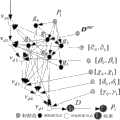
图2参数化设计模型对应超图模型示例。 Figure 2 An example of a hypergraph model corresponding to a parametric design model. the
图3是Doulas-Peucker方法化简曲线的原理图。 Fig. 3 is a schematic diagram of the simplified curve of the Doulas-Peucker method. the
图4是凸顶点的直角化处理示意图。 Fig. 4 is a schematic diagram of the right-angled processing of convex vertices. the
图5是凹顶点的外扩示意图。 Fig. 5 is a schematic diagram of the expansion of the concave apex. the
图6是凹顶点的直角化处理的示意图。 FIG. 6 is a schematic diagram of the right-angled processing of concave vertices. the
图7是参数化设计模型对应超图模型示意图。 Fig. 7 is a schematic diagram of a hypergraph model corresponding to a parametric design model. the
图8是居民地多边形图形化简前后示意图。 Fig. 8 is a schematic diagram before and after simplification of polygonal graphics of residential areas. the
五、具体实施方式5. Specific implementation
以下结合流程图对本发明的具体实施方式作详细说明。 The specific implementation of the present invention will be described in detail below in conjunction with the flowchart. the
由图1的流程图给出,本发明是由以下步骤实现: Provided by the flowchart of Fig. 1, the present invention is realized by the following steps:
1、参数化设计模型及其形式化表示 1. Parametric design model and its formal representation
在机械设计及制造业中,参数化设计一般是指用一组参数约束几何图形的一组结构尺寸序列,参数与设计对象的控制尺寸有显式对应,当赋予不同的参数序列值时,就可驱动原几何图形达到新的目标几何图形,把整个上述产品设计的过程模型化的结果就是参数化设计模型; In mechanical design and manufacturing, parametric design generally refers to a set of structural dimension sequences that constrain geometric figures with a set of parameters. The parameters have an explicit correspondence with the control dimensions of the design object. When different parameter sequence values are assigned, It can drive the original geometry to reach the new target geometry, and the result of modeling the entire above-mentioned product design process is a parametric design model;
参数化设计方法的研究早在20世纪60年代就已经开始,Sutherland在他开发的Sketchpad系统中,首次将几何约束表示为非线性方程组来确定二维几何形体的形状和位置,后来,Hillyard,Gossard进一步发展这一思想,并使之实用化,经过40年来的发展,参数化设计模型和思想已经成为现代CAD/CAM系统的核心技术。 The research on parametric design methods started as early as the 1960s. In the Sketchpad system he developed, Sutherland expressed geometric constraints as nonlinear equations for the first time to determine the shape and position of two-dimensional geometric objects. Later, Hillyard, Gossard further developed this idea and made it practical. After 40 years of development, parametric design models and ideas have become the core technology of modern CAD/CAM systems. the
一般说来,实现参数化设计,必须具备如下几个条件: Generally speaking, to achieve parametric design, the following conditions must be met:
(1)在产品设计模型中,应能够包含几何拓扑关系和各种约束关系; (1) In the product design model, it should be able to include geometric topological relations and various constraint relations;
(2)几何图形应能由尺寸驱动; (2) Geometry should be driven by dimensions;
(3)设计参数与几何图形尺寸具有对应关系; (3) There is a corresponding relationship between design parameters and geometric figure dimensions;
满足上述条件的产品几何图形,既描述了产品的几何形状,又包含了设计者的设计思想和设计知识,因此,它是产品的设计模型,当给定设计参数一组具体设计数据后,该模型会自动生成整个设计结果,居民地多边形的化简完全可以实现参数化设计,因为它基本上满足上文中实现参数化设计必须具备的几个条件,但是,具体的实现过程却又与机械产品的设计有很大的不同,比如,产品设计的最终结果和评判标准比较明确,但是多边形的化简的结果和评判标准不确定,且不容易定量描述;产品设计的约束条件很容易确定,但居民地多边形化简的约束条件很难将其定量描述; The product geometry that satisfies the above conditions not only describes the geometric shape of the product, but also contains the designer's design ideas and design knowledge. Therefore, it is the design model of the product. When a set of specific design data is given, the The model will automatically generate the entire design result, and the simplification of the polygons of residential areas can completely realize the parametric design, because it basically meets the above-mentioned conditions that must be met for the realization of the parametric design. However, the specific realization process is different from the mechanical design. Product design is very different. For example, the final result and evaluation criteria of product design are relatively clear, but the results and evaluation criteria of polygon simplification are uncertain and not easy to describe quantitatively; the constraints of product design are easy to determine. However, the constraints of polygon simplification of residential areas are difficult to describe quantitatively;
参数化设计模型的建立和求解过程可以被认为是在约束的建立与满足的过程中,求得一组最优的参数,因此,参数化设计模型从本质上讲就是参数化约束模型,其关键是约束模型的表达能力和求解计算的效率,先介绍下面几个专有名词: The establishment and solution process of a parametric design model can be considered as obtaining a set of optimal parameters in the process of establishing and satisfying constraints. Therefore, a parametric design model is essentially a parametric constraint model, and its key It is the expression ability of the constraint model and the efficiency of solution calculation. First, the following proper terms are introduced:
定义1设计对象是指参数化设计模型的研究对象,比如点、线、面、圆、设计尺寸和设计规格等,在居民地多边形的化简过程中,还会涉及到面边线局部极值点、基本弯曲的特征参量、多边形的方向、多边形顶点的凸凹性、多边形的面积、周长和最小外接矩形等等;
定义2设计约束指设计对象之间需要满足的各种关系;
定义3参数化设计模型将其定义如下: Definition 3 Parametric design model defines it as follows:
PDM=<∑,C> PDM=<∑, C>
PDM为参数化设计模型, PDM is a parametric design model,
∑为约束顶点集合(又称为“超图顶点”),则: ∑ is a set of constrained vertices (also known as "hypergraph vertices"), then:
∑=G∪P∪D ∑=G∪P∪D
其中,G={g1,g2,...,gl}是图形中的所有设计对象; Among them, G={g1 , g2 ,..., gl } are all design objects in the graph;
P={p1,p2,...,pm}是图形中所有顶点的集合; P={p1 , p2 ,..., pm } is the set of all vertices in the graph;
D={d1,d2,...,dn}是图形中所有尺寸(或阈值)的集合; D={d1 , d2 ,...,dn } is the set of all dimensions (or thresholds) in the graph;
C是约束边(将其定义为“超图边”)的集合,C={<vd1,V1>,<vd2,V2>,...,<vdk,Vk>},表示设计对象之间的单向约束关系,它由超图顶点集合E和约束类型Et组成,在超图顶点集合Et中,vdi表示约束边(超图边)的目标顶点,Vi为一有序n元组,表示目标顶点依赖的所有前驱顶点(源顶点) C is the set of constrained edges (defined as "hypergraph edges"), C={<vd1 , V1 >, <vd2 , V2 >, ..., <vdk , Vk >}, Indicates the one-way constraint relationship between design objects, which consists of a hypergraph vertex set E and a constraint type Et . In the hypergraph vertex set Et , vdi represents the target vertex of a constraint edge (hypergraph edge), Vi It is an ordered n-tuple, representing all the predecessor vertices (source vertices) that the target vertex depends on
其中,vdi∈∑,
Et表示不同类型的约束关系,设计对象vdi的约束计算方法是由其前驱顶点和约束类型Et所决定的,也就是: Et represents different types of constraint relationships, and the constraint calculation method of the design object vdi is determined by its predecessor vertex and constraint type Et , that is:
vdi=Rc(Vi) vdi =Rc (Vi )
Rc表示该约束的类型,这就说明每条约束边(超图边)表示图形中的一个约束关系,并且目标顶点由前驱顶点和约束类型来决定。 Rc represents the type of the constraint, which means that each constraint edge (hypergraph edge) represents a constraint relationship in the graph, and the target vertex is determined by the predecessor vertex and the constraint type.
定义4参数化设计模型对应的数学模型是指将参数化设计模型中的各种约束关系用一组线性或非线性方程组来表示,通过求解该方程组来确定目标顶点(形如上文中vdi=Rc(Vi))。 Definition 4 The mathematical model corresponding to the parametric design model refers to expressing various constraints in the parametric design model with a set of linear or nonlinear equations, and determining the target vertex by solving the equations (formed as vdi =Rc (Vi )).
定义5参数化设计模型对应的超图模型是指将上文中的各种超图边和超图顶点以更形象和直观的形式表示,以此来表达各种约束顶点、约束边和目标顶点之间的约束关系和约束边对应目标顶点(vdi)的求解流程,为求解参数化设计模型对应的数学模型做好准备,超图模型主要是由超图顶点和超图边组成,超图顶点包括约束顶点集合,超图边表示超图顶点之间的约束关系,由设计对象链约束边集合构成,超图中的每一个顶点都由指向它的超图边和相应的顶点求解。 Definition 5 The hypergraph model corresponding to the parametric design model refers to the above-mentioned various hypergraph edges and hypergraph vertices in a more vivid and intuitive form to express the relationship between various constraint vertices, constraint edges and target vertices. The constraint relationship between constraints and the solution process of the target vertex (vdi ) corresponding to the constraint edge are prepared for solving the mathematical model corresponding to the parametric design model. The hypergraph model is mainly composed of hypergraph vertices and hypergraph edges. The hypergraph vertex Including the constraint vertex set, the hypergraph edge represents the constraint relationship between the hypergraph vertices, which is composed of the design object chain constraint edge set, and each vertex in the hypergraph is solved by the hypergraph edge pointing to it and the corresponding vertex.
以图2(a)为例来说明机械产品设计的参数化设计模型对应超图模型的建立过程,图2(b)是参数化设计模型对应的超图(以该图来表示模型的建立过程),设矩形起始点为A,宽为w,高为h,倒角半径为r,w,h,r为可变参数。 Taking Figure 2(a) as an example to illustrate the establishment process of the hypergraph model corresponding to the parametric design model of mechanical product design, Figure 2(b) is the hypergraph corresponding to the parametric design model (this graph is used to represent the establishment process of the model ), let the starting point of the rectangle be A, the width be w, the height be h, the chamfering radius be r, w, h, and r be variable parameters. the
在图形的绘制过程中,先定义起始点A并给可变参数w,h,r赋值,然后定义水平线段LAB(两端点分别为A和B),则B点由点A和水平距离w决定,指向LAB的有向边为<LAB,{A,B}>,指向B的有向边为<B,{A,w}>,同理,倒圆的圆心点O,起点C和终点D的有向边分别为:<O,{L1,L2,r}>,<C,{L1,L2,r}>,<D,{L1,L2,r}>,类似的可建立线段LBC,LED和圆R的约束关系。 In the drawing process of graphics, first define the starting point A and assign values to the variable parameters w, h, r, and then define the horizontal line segment LAB (the two ends are A and B respectively), then point B is formed by point A and the horizontal distance w It is determined that the directed edge pointing toLAB is <LAB , {A, B}>, and the directed edge pointing to B is <B, {A, w}>. Similarly, the center point O of the rounding circle and the starting point C The directed edges with the terminal D are: <O, {L1, L2, r}>, <C, {L1, L2, r}>, <D, {L1, L2, r}>, similarly can be established Constraint relation of line segments LBC , LED and circle R.
图中左边粗有向链称之为设计对象链CDO(Chain of Design Object),主要用来记录和表示设计对象的绘制次序及依赖关系,因此,可以按CDO的链的次序依次求解计算设计对象便得到超图的解,也就是每给定一组初值(w,h,r)和初始点(A),利用参数化设计模型对应的超图便可计算出一个新的实例。 The thick directed chain on the left in the figure is called CDO (Chain of Design Object), which is mainly used to record and represent the drawing order and dependencies of design objects. Therefore, the calculation design objects can be solved in sequence according to the order of CDO chains The solution of the hypergraph is obtained, that is, for each given set of initial values (w, h, r) and initial point (A), a new instance can be calculated by using the hypergraph corresponding to the parametric design model. the
图2中指向某一目标顶点的所有细有向边的起点构成求解该顶点约束的前驱顶点,无入边的顶点称之为图形的可变参数和参数化点(如w,h,r和点A)。 In Figure 2, the starting points of all thin directed edges pointing to a certain target vertex constitute the precursor vertices for solving the constraint of the vertex, and the vertices without incoming edges are called variable parameters and parameterized points of the graph (such as w, h, r and point A). the
2、识别居民地多边形的图形特征 2. Identify the graphic features of residential polygons
(1)利用坐标单调性判别方法来识别局部极值点和基本弯曲,假定有n个点的多边形点序列P((x1,y1),(x2,y2),...,(xn,yn)),如果能将这n个点组成的点序列拟合成为一条函数曲线y=f(x),f(x)在[x1,xn-1]上连续,在(x1,xn-1)上可导,那么判断多边形的单调性就是判断函数y=f(x)在[x1,xn-1]单调情况,只须求解f(x)的导数,然后判断f′(x)在区间[x1,xn-1]上的取值情况,就可以得到曲线的各个单调段和局部极值点。 (1) Use the coordinate monotonicity discrimination method to identify local extremum points and basic bends, assuming a polygonal point sequence P((x1 , y1 ), (x2 , y2 ),..., (xn , yn )), if the point sequence composed of n points can be fitted into a function curve y=f(x), f(x) is continuous on [x1 , xn-1 ], It can be derived on (x1 , xn-1 ), then judging the monotonicity of the polygon is judging the monotonicity of the function y=f(x) in [x1 , xn-1 ], only need to solve f(x) Derivative, and then judging the value of f′(x) in the interval [x1 , xn-1 ], each monotone segment and local extreme point of the curve can be obtained.
但是在实际情况中,大多数多边形的坐标数据不可能拟合成为一条严格的数学曲线,因此我们只能从函数的导数和单调性的基本定义出发,近似的对多变形进行单调分段并求取局部极值点。 However, in actual situations, most polygonal coordinate data cannot be fitted into a strict mathematical curve, so we can only proceed from the basic definition of the derivative of the function and monotonicity, and approximate the monotonic segmentation of the multi-deformation and find Take the local extremum point. the
设函数f(x)在[a,b]上连续,在(a,b)内可导,在[a,b]上任取两点x1,x2(x1<x2),应用拉格朗日中值定理,得到 Let the function f(x) be continuous on [a, b], and be differentiable in (a, b), take any two points x1 and x2 on [a, b] (x1 < x2 ), apply pull Grange's median value theorem, we get
f(x2)-f(x1)=f′(ξ)(x2-x1)(x1<ξ<x2) (1) f(x2 )-f(x1 )=f′(ξ)(x2 -x1 )(x1 <ξ<x2 ) (1)
由于在(1)式中,x2-x1>0,因此,如果在(a,b)内导数f′(x)保持正号,即f′(x)>0,那么也有f′(ξ)>0,于是 Since in formula (1), x2 -x1 >0, if the derivative f′(x) in (a, b) maintains a positive sign, that is, f′(x)>0, then there is also f′( ξ)>0, so
f(x2)-f(x1)=f′(ξ)(x2-x1)>0,即 f(x2 )-f(x1 )=f′(ξ)(x2 -x1 )>0, namely
f(x1)<f(x2) f(x1 )<f(x2 )
表明函数f(x)在[a,b]上单调增加,同理,若f′(x)<0,表明函数f(x)在[a,b]上单调递减,如果导数值不为0,则ξ为单调点,否则可能为局部极值点。 Indicates that the function f(x) increases monotonically on [a, b]. Similarly, if f′(x)<0, it indicates that the function f(x) decreases monotonically on [a, b]. If the derivative value is not 0 , then ξ is a monotonic point, otherwise it may be a local extreme point. the
通过以上关于单调性的判别方法可以发现,对于离散的点序列,要判断其坐标的单调性,至少需要3个点,即判断3个点中中间点是否为单调点,可通过以下方法进行判别: Through the above method of discriminating monotonicity, it can be found that for a discrete point sequence, to judge the monotonicity of its coordinates, at least 3 points are needed, that is, to judge whether the middle point of the 3 points is a monotonic point, the following method can be used for discrimination :
当1<i<n时,若式(2)成立,则定义点(xi,yi)为该多边形的单调点,否则为局部极值点(或者叫歧点)。 When 1<i<n, if formula (2) holds true, define the point (xi, yi ) as the monotonic point of the polygon, otherwise it is a local extremum point (or divergence point).
当i=1时,若式(3)成立,则定义多边形起点(x1,x2)为单调点,否则为局部极值点。 When i=1, if formula (3) holds true, define the polygon starting point (x1 , x2 ) as a monotonic point, otherwise it is a local extremum point.
当i=n时,若式(4)成立,则定义多边形起点(x1,x2)为单调点,否则为局部极值点。 When i=n, if formula (4) holds true, define the polygon starting point (x1 , x2 ) as a monotone point, otherwise it is a local extremum point.
通过以上三式基本上可以将多边形坐标点序列中的单调点和局部极值点区分出来,但是在具体实施的过程中,某些局部极值点可能不会严格符合以上三式,这时就需要将这些局部极值点退化为单调点,定义当前歧点与其前后两点连线夹角θ与180°差的绝对值为Ω,当Ω小于规定阈值β时,则将当前歧点退化为单调点;否则,将其定义为局部极值点,β一般不应大于40°。 The above three formulas can basically distinguish the monotonic point and the local extremum point in the polygon coordinate point sequence, but in the process of specific implementation, some local extremum points may not strictly conform to the above three formulas, at this time It is necessary to degenerate these local extreme points into monotonic points, and define the absolute value of the difference between the angle θ and 180° between the current divergence point and the line between the two points before and after it and 180°, and when Ω is less than the specified threshold β, the current divergence point is degenerated into Monotonic point; otherwise, it is defined as a local extremum point, and β should generally not be greater than 40°. the
设从多边形的点序列Pi(i=1,...,n)识别出m个特征点TPj(m≤n,j=0,...,m-1),则可以将{TPj-1,TPj,TPj+1}之间的所有点(包括这三个特征点)看成一个基本弯曲,一共可以划分为m-1个基本弯曲。 Assuming that m feature points TPj (m≤n, j=0,..., m-1) are identified from the polygonal point sequence Pi (i=1,...,n), then {TP All points betweenj-1 , TPj , TPj+1 } (including these three feature points) are regarded as a basic bend, which can be divided into m-1 basic bends in total.
(2)居民地多边形的方向及顶点凸凹性的判别,本发明运用相邻边矢量叉乘确定居民地多边形的方向及凸凹性,设居民地对应多边形的顶点序列为Pi(i=1,...,n),取相邻的三点Pi-1,Pi,Pi+1,若Pi-1Pi与PiPi+1所夹的角小于或等于π,则称点Pi是凸的,否则Pi是凹的,在此基础上取向量Pi-1Pi与PiPi+1作叉乘,若点Pi是凸的,并且叉乘结果为负,则对应多边形为顺时针,反之则否。 (2) Discrimination of the direction of the residential area polygon and the convexity of the vertex. The present invention uses the cross product of adjacent side vectors to determine the direction and the convexity of the residential area polygon. The vertex sequence of the corresponding polygon of the residential area is Pi (i=1, ..., n), take the adjacent three points Pi-1 , Pi , Pi+1 , if the angle between Pi-1 Pi and Pi Pi+1 is less than or equal to π, then Point Pi is said to be convex, otherwise Pi is concave, on this basis, take vector Pi-1 Pi and Pi Pi+1 for cross product, if point Pi is convex, and the result of cross product If it is negative, the corresponding polygon is clockwise, and vice versa.
3、居民地多边形化简的渐进式图形化简方法设计 3. Design of progressive graphic simplification method for polygon simplification of residential areas
渐进式的图形化简方法是指在基于参数化设计模型的居民地多边形化简过程中,每给定一组初值和相应的各种阈值,就对图形进行一次化简的具体实施过程,其基本思路是:在对图形特征识别的基础上,以渐进式的方式对居民地多边形逐点逐段的进行处理,过程如下: The progressive graphic simplification method refers to the specific implementation process of simplification of the graphics once a set of initial values and corresponding threshold values are given in the process of simplification of residential area polygons based on parametric design models. The basic idea is: based on the recognition of graphic features, the residential polygons are processed point by point and segment by point in a gradual manner. The process is as follows:
(1)利用Doulas-Peucker方法删除冗余点。 (1) Use the Doulas-Peucker method to delete redundant points. the
Douglas-Peucker方法是基于Attneave(1954)的理论:曲线图形的信息主要集中在曲线的特征点上,特征点多发生在弯曲大(转角大)的地方(Kelley,1977),也就是极值点,该方法的基本思想是:连接线的首末结点,计算其余各点到该连线的距离,比较最大距离与限差DP的大小,将DP称之为Douglas-Peucke方法化简曲线的阈值,若最大距离小于限差,用该连线代替曲线,否则保留最大距离的点,依次重复上述步骤(见附图3)。 The Douglas-Peucker method is based on the theory of Attneave (1954): the information of the curve graphics is mainly concentrated on the characteristic points of the curve, and the characteristic points mostly occur in places with large bends (large corners) (Kelley, 1977), that is, extreme points , the basic idea of this method is: to connect the first and last nodes of the line, calculate the distance from the remaining points to the connection line, compare the maximum distance and the size of the tolerance DP, and call DP the Douglas-Peucke method to simplify the curve Threshold, if the maximum distance is less than the tolerance, replace the curve with the connection line, otherwise keep the point with the maximum distance, and repeat the above steps in turn (see Figure 3). the
(2)凸顶点的删除处理,必须同时满足二个条件才能将其删除:①弯曲顶角要极大或要极小;②弯曲口径和弯曲高度都小于给定的阈值。 (2) For the deletion processing of convex vertices, two conditions must be met at the same time to delete them: ①The angle of the curved vertex must be extremely large or extremely small; ②Both the diameter of the bend and the height of the bend are smaller than a given threshold. the
(3)对凸顶点的直角化处理,对于大比例尺地图数据,房屋顶点的直角一般都能保持,但是对于中小比例尺数据,由于不是实测得到,一般是通过遥感影像数据获取居民地外围轮廓,不像大比例尺上建筑物的轮廓一样有典型的直角化痕迹,但为了保持化简后轮廓的简洁整齐,还是有必要将弯曲直角化,因此当凸顶点不满足删除条件,并且弯曲的两条边小于一定的阈值时,对其进行直角化改正,如附图4所示,A’和B’是凸顶点A和B经过直角化之后的点,如果A大于B,则取A’为最后的直角化点。 (3) For the right-angle processing of convex vertices, for large-scale map data, the right angles of house vertices can generally be maintained, but for small-scale and medium-scale data, since it is not obtained from actual measurements, the outer contours of residential areas are generally obtained through remote sensing image data. Like the outline of a building on a large scale, there are typical right-angled traces, but in order to keep the simplified outline neat and tidy, it is still necessary to right-angle the bend, so when the convex vertex does not meet the deletion condition, and the two curved sides When it is less than a certain threshold, it is rectified and corrected. As shown in Figure 4, A' and B' are the points after the convex vertices A and B have been perpendicularized. If A is greater than B, then A' is taken as the last Orthogonal points. the
(4)对凹顶点的删除处理,删除的条件同凸顶点的条件一样,但阈值的设置适当放大。 (4) For the deletion of concave vertices, the deletion conditions are the same as those of convex vertices, but the setting of the threshold is enlarged appropriately. the
(5)对凹顶点的外扩处理,如果凹顶点不满足删除条件并满足以下条件,则对其进行外扩处理,①凹顶点的顶角尖锐程度大于给定的阈值(尖锐程度是指弯曲高度与弯曲口径的比值);②弯曲面积小于给定的阈值;③前后相邻的两个顶点是凸顶点且弯曲顶角接近90度,如附图5所示,A’即为化简后A点的位置。 (5) For the external expansion processing of the concave vertex, if the concave vertex does not meet the deletion condition and satisfies the following conditions, then it will be expanded. The ratio of the height to the bending diameter); ②The bending area is less than a given threshold; ③The two adjacent vertices are convex and the bending angle is close to 90 degrees. As shown in Figure 5, A' is the simplified The location of point A. the
(6)对凹顶点的直角化处理,如果凹顶点不满足删除和外扩条件,须对其进行直角化处理,如附图6所示。 (6) Right-angle processing of the concave vertex, if the concave vertex does not meet the deletion and expansion conditions, it must be processed at right angles, as shown in Figure 6. the
经过以上六步处理,就完成了一次化简过程,但上述过程中的阈值需要经过求解参数化设计模型(居民地多边形化简对应参数化设计模型的超图模型和数学模型见下文第5节和第6节)才能得到。 After the above six steps of processing, a simplification process is completed, but the threshold in the above process needs to be solved through the parametric design model (the hypergraph model and mathematical model of the residential polygon simplification corresponding to the parametric design model are shown in Section 5 below. and Section 6) to obtain. the
4、居民地多边形化简的约束分析 4. Constraint analysis of polygon simplification of residential areas
将居民地多边形化简过程所遵循的各种约束分为几何尺寸约束、结构特征约束和几何关系约束: The various constraints followed in the polygon simplification process of residential areas are divided into geometric size constraints, structural feature constraints and geometric relationship constraints:
(1)几何尺寸约束,包括化简过程中的各种参数和阈值;还包括面积约束和距离约束,将面积约束定义为: (1) Geometric size constraints, including various parameters and thresholds in the simplification process; also include area constraints and distance constraints, the area constraints are defined as:
S2为化简后的面积,S1为化简前的面积。 S2 is the area after simplification, and S1 is the area before simplification.
将相邻点之间的距离约束定义为I2,这一指标是评价化简后对冗余点的删除情况,本文以化简前后点数的比值来代替计算距离。 The distance constraint between adjacent points is defined as I2 , which is to evaluate the deletion of redundant points after simplification. In this paper, the ratio of points before and after simplification is used to replace the calculated distance.
N2为化简后点数,N1为化简前的点数。 N2 is the number of points after simplification, and N1 is the number of points before simplification.
(2)结构特征约束,结构特征约束以保持化简前后的总体结构特征不会变化太大,包括: (2) Structural feature constraints, structural feature constraints to keep the overall structural features before and after simplification will not change too much, including:
①决定顶点是否为局部极值点的阈值约束,主要是指前文中所述β的值; ① The threshold constraint to determine whether the vertex is a local extreme point mainly refers to the value of β mentioned above;
②最小外接矩形长对角线方向偏移程度,以此来约束化简后封闭图形的方向,定义I3为: ② The offset degree of the long diagonal direction of the minimum circumscribed rectangle, in order to constrain the direction of the closed figure after simplification, define I3 as:
θ2为化简后长对角线与水平方向的夹角,θ1为化简前长对角线与水平方向的夹角; θ2 is the angle between the long diagonal and the horizontal direction after simplification, and θ1 is the angle between the long diagonal and the horizontal direction before simplification;
③最小外接矩形长短轴之比,以此来约束封闭图形的整体形状,定义I4为: ③ The ratio of the major and minor axes of the minimum circumscribed rectangle is used to constrain the overall shape of the closed figure, and the definition I4 is:
I4=|R1-R2|(δ0<I4<δ1) (8) I4 =|R1 -R2 |(δ0 <I4 <δ1 ) (8)
R2为化简后长短轴之比,R1为化简前长短轴之比。 R2 is the ratio of long and short axes after simplification, and R1 is the ratio of long and short axes before simplification.
(3)几何关系约束,几何关系约束既包括图形对象之间平行、垂直、相接、相离等约束,这里主要是指直角化约束,这里以I5来约束化简后整个图形的直角化程度: (3) Geometric relationship constraints. Geometric relationship constraints include constraints such as parallelism, verticality, connection, and separation between graphic objects. Here, it mainly refers to the right-angled constraint. Here, I5 is used to constrain the right-angled of the whole figure after simplification. degree:
θi是化简后第i个局部极值点的顶角值;l是指多边形局部极值点的个数为1、2、3……n个; 
5、参数化设计模型对应的超图模型的设计 5. Design of hypergraph model corresponding to parametric design model
建立超图模型的目的是为了求解各个约束边的目标顶点,从而为建立和求解数学模型做好准备。 The purpose of establishing the hypergraph model is to solve the target vertices of each constraint edge, so as to prepare for the establishment and solution of the mathematical model. the
超图模型的建立分为以下步骤: The establishment of the hypergraph model is divided into the following steps:
(1)约束顶点集合确定 (1) Determination of the set of constrained vertices
约束顶点集合E主要包括多边形的所有设计对象G、化简前所有顶点集合P1和化简后顶点集合P2、化简过程中所有未知阈值集合D: The constrained vertex set E mainly includes all polygonal design objects G, all vertex sets P1 before simplification, vertex set P2 after simplification, and all unknown threshold sets D during the simplification process:
E=G∪P1∪P2∪D (10) E=G∪P1 ∪P2 ∪D (10)
其中G包括: where G includes:
①所有局部极值点集合g1:g1={gpi|gpi∈N,i=1,...,l},gpi为多边形局部极值点的顶点序号; ①All local extremum point sets g1 : g1 ={gpi |gpi ∈N, i=1,...,l}, gpi is the vertex number of the local extremum point of the polygon;
②基本弯曲及其特征参量集合g2:g2={gbi|gbi∈|gbi},i=1,...,l-1},其中gbi={gp(i-1),gpi,gp(i+1)}(1<i≤l),由基本弯曲的顶点序号可以得到相应的顶点坐标,进而可以求出弯曲口径、弯曲高度、弯曲角度和弯曲面积等特征参量; ②Basic bending and its characteristic parameter set g2 : g2 ={gbi |gbi ∈|gbi }, i=1,...,l-1}, where gbi ={gp(i-1 ) , gpi , gp(i+1) }(1<i≤l), the corresponding vertex coordinates can be obtained from the basic curved vertex number, and then the bending diameter, bending height, bending angle and bending area can be obtained characteristic parameters;
③多边形的方向g3:g3={gd|gd∈{0,1}},当gd的值为0时为顺时针,为1时为逆时针方向; ③The direction g3 of the polygon: g3 ={gd |gd ∈ {0, 1}}, when the value of gd is 0, it is clockwise, and when it is 1, it is counterclockwise;
④顶点的凸凹性g4:g4={gki|gki∈{0,1}},i=1,...,l,当gki的值为0时该顶点为凹顶点,为1时为凸顶点; ④Convexity g4 of the vertex: g4 ={gki |gki ∈{0,1}}, i=1,...,l, when the value of gki is 0, the vertex is a concave vertex, which is 1 is a convex vertex;
⑤多边形的面积、周长g5:g5={gsi|gsi∈R,i=1,2},其中gs1为多边形面积,gs2为多边形周长; ⑤Area and perimeter g5 of the polygon: g5 = {gsi |gsi ∈ R, i=1, 2}, where gs1 is the area of the polygon, and gs2 is the perimeter of the polygon;
⑥最小外接矩形g6:g6={(xi,yi)xi∈R,yi∈R,i=1,2,3,4} ⑥ Minimum circumscribed rectangle g6 : g6 = {(xi, yi ) xi ∈ R, yi ∈ R, i=1, 2, 3, 4}
综上,则设计对象 In summary, the design object
G={gi|i=1,2,4,5,6} G={gi |i=1, 2, 4, 5, 6}
顶点集合包括化简前的集合P1和化简前后的集合P2: The vertex set includes the set P1 before simplification and the set P2 before and after simplification:
P1={(xi,yi)|i=1,...,m,xi∈R,yi∈R} P1 = {(xi , yi )|i=1, . . . , m, xi ∈ R, yi ∈ R}
P2={(xj,yj)|j=1,...,n,xj∈R,yj∈R} P2 ={(xj ,yj )|j=1,...,n, xj ∈ R, yj ∈ R}
根据渐进式图形化简方法,化简过程中所有未知的阈值集合D包括: According to the progressive graph simplification method, all unknown threshold sets D in the simplification process include:
Douglas-Pucker方法删除冗余点时的阈值d1;决定顶点是否为局部极值点的阈值d2;删除凸顶点时需要确定的弯曲顶角d3(这里规定为锐角,若为钝角,直接与π相差即可)、弯曲口径d4和弯曲高度d5;删除凹弯曲时需要确定弯曲口径d6和弯曲高度d7;对凹顶点进行外扩处理时的尖锐程度d8和基本弯曲的面积阈值d9,则最优阈值集合D为The threshold d1 for Douglas-Pucker method to delete redundant points; the threshold d2 for determining whether a vertex is a local extremum point; the curved vertex angle d3 that needs to be determined when deleting a convex vertex (here specified as an acute angle, if it is an obtuse angle, directly difference from π), bending caliber d4 and bending height d5 ; the bending caliber d6 and bending height d7 need to be determined when deleting the concave bend; the sharpness d8 and the basic bending height of the concave vertex area threshold d9 , then the optimal threshold set D is
D={di|i=1,...,9,di∈R} D={di |i=1,...,9, di ∈ R}
(2)约束边集合分析 (2) Constrained edge set analysis
约束边集合是指源约束顶点集合与目标约束顶点集合之间的关系集合C,定义C为: The constrained edge set refers to the relationship set C between the source constrained vertex set and the target constrained vertex set, and C is defined as:
vdi是约束顶点集合中的元素,它是有向边的目标顶点,也就是化简后的约束顶点,Vi是源顶点集合,即化简前的约束顶点集合,所以,约束边就是某一目标约束顶点与源约束顶点集合之间的关系,即: Vdi is the element in the constraint vertex set, it is the target vertex of the directed edge, that is, the constraint vertex after simplification, Vi is the source vertex set, that is, the constraint vertex set before simplification, so the constraint edge is a certain The relationship between a target constraint vertex and a source constraint vertex set, namely:
vdi=Rci(Vi) (11) vdi =Rci (Vi ) (11)
Rci表示约束的类型,这里以约束分析中的I1、I2、I3、I4、I5和g1来表征E中的目标约束顶点,以未知阈值集合D来表征源约束顶点集合Vi,则由式(5)可得: Rci represents the type of constraint, where I1 , I2 , I3 , I4 , I5 and g1 in constraint analysis are used to represent the target constrained vertices in E, and the unknown threshold set D is used to characterize the source constrained vertex set Vi , then it can be obtained from formula (5):
其中,Rc1为面积约束,那么V1则主要由阈值集合D={di|i=1,...,9,di∈R}构成,故而 Among them, Rc1 is an area constraint, then V1 is mainly composed of threshold value set D={di |i=1,...,9, di ∈ R}, so
同理: In the same way:

vd4=Rc4(D)=|R1-R2| (16) vd4 =Rc4 (D)=|R1 -R2 | (16)
其中,Rc2为距离约束、Rc3为方向约束、Rc4为整体形状约束、Rc5为直角约束,Rc6为结构特征约束,综上,则C为: Among them, Rc2 is a distance constraint, Rc3 is a direction constraint, Rc4 is an overall shape constraint, Rc5 is a right angle constraint, and Rc6 is a structural feature constraint. In summary, C is:
由此通过约束边就可以用一系列参数(阈值)将居民地多边形的有关几何信息、约束信息和结构信息有机的连结起来,为参数化设计模型的建立与求解做好准备; Therefore, a series of parameters (thresholds) can be used to organically link the geometric information, constraint information and structural information of the polygon of the residential area through the constrained edge, making preparations for the establishment and solution of the parametric design model;
(3)参数化设计模型对应的超图建立 (3) Establishment of the hypergraph corresponding to the parametric design model
附图7所示为居民地多边形化简的参数化设计模型对应的超图模型,超图模型主要是由超图顶点和超图边组成,超图顶点包括约束顶点集合E构成,超图边表示超图顶点之间的约束关系,由设计对象链CDO和约束边集合C构成,超图中的每一个顶点都由指向它的超图边和相应的顶点求解。 Accompanying drawing 7 shows the hypergraph model corresponding to the parametric design model of residential polygon simplification. The hypergraph model is mainly composed of hypergraph vertices and hypergraph edges. The hypergraph vertices include the constraint vertex set E, and the hypergraph edges Represents the constraint relationship between the vertices of the hypergraph, which is composed of the design object chain CDO and the set of constraint edges C. Each vertex in the hypergraph is solved by the hypergraph edge pointing to it and the corresponding vertex. the
6、参数化设计模型对应的数学模型的设计 6. Design of the mathematical model corresponding to the parametric design model
在渐进式图形化简方法的支持下,通过构建相应的超图,计算就可以对居民地多边形进行了一次化简,即完成了一次由P1到P2的过程,它只是可行域内的一个解,要寻求最优解,还需要建立参数化设计模型对应的数学模型。 With the support of the progressive graph simplification method, by constructing the corresponding hypergraph, the calculation can simplify the residential polygon once, that is, the process from P1 to P2 is completed, and it is only a part of the feasible region. To find the optimal solution, it is necessary to establish a mathematical model corresponding to the parametric design model.
很显然,这个数学模型就是在有约束限制下的寻优问题,约束条件就是(11)式中目标约束顶点与源约束顶点之间的约束关系式,而目标函数则是关于未知阈值di(i=1,...,9)的极小化函数,参数化设计模型对应的数学模型的一般形式为: Obviously, this mathematical model is an optimization problem under constraints. The constraint is the constraint relationship between the target constraint vertex and the source constraint vertex in formula (11), and the objective function is about the unknown threshold di ( i=1,...,9), the general form of the mathematical model corresponding to the parametric design model is:
minf(D) minf(D)
但关于D的函数关系式是非常隐性的,很难得到其解析表达式,但通过分析式(13)到式(18)发现,关于D的函数可以由I1、I2、I3、I4和I5来表达,而它们则有明确的解析表达式,因此将(19)式转化为: However, the functional relationship of D is very implicit, and it is difficult to obtain its analytical expression. However, through the analysis of formulas (13) to (18), it is found that the function of D can be expressed by I1 , I2 , I3 , I4 and I5 to express, and they have clear analytic expressions, so the formula (19) is transformed into:
bj(j=1,2,3,4,5)是根据Ii对决定化简结果优劣贡献的大小,据此数学模型,当每给定一组初始阈值 
7、超图模型和数学模型的求解 7. Solution of hypergraph model and mathematical model
(1)超图表示模型的求解 (1) Solution of hypergraph representation model
模型的求解以CDO链为主线,以渐进式的图形化简方法为核心,依次遍历整个超图模型的顶点和边,最终结果就是约束边对应的目标顶点(vdj),主要步骤: The solution of the model takes the CDO chain as the main line, takes the progressive graph simplification method as the core, and traverses the vertices and edges of the entire hypergraph model in turn, and the final result is the target vertex (vdj ) corresponding to the constrained edge. The main steps are:
Step1:将初始参数值赋给相应的初始顶点,即将阈值集合D对应的初始阈值 

Step2:从CDO链的初始顶点vd6开始,遍历到与其对应的所有前驱顶点,若vd6的所有前驱顶点都已计算完成,转Step4; Step2: Starting from the initial vertex vd6 of the CDO chain, traverse to all the precursor vertices corresponding to it, if all the precursor vertices of vd6 have been calculated, go to Step4;
Step3:若vd6的所有前驱顶点中有一个以上顶点没有计算完成,则再计算该顶点的前驱顶点,直到vd6的所有前驱顶点都计算完成; Step3: If more than one vertex of all the predecessor vertices of vd6 has not been calculated, then calculate the predecessor vertices of this vertex until all the predecessor vertices of vd6 are calculated;
Step4:根据vd6与其所有前驱顶点之间的约束关系计算出vd6; Step4: Calculate vd6 according to the constraint relationship between vd6 and all its predecessor vertices;
Step5:重复以上步骤,直到计算出CDO链上的所有顶点; Step5: Repeat the above steps until all vertices on the CDO chain are calculated;
通过对超图模型的求解,可以计算出一组Ii值; By solving the hypergraph model, a set of Ii values can be calculated;
从方法流程看出,上述求解方法实际上是对超图的一次遍历过程,此时方法的复杂度为O(n),n为超图模型的顶点数目。 It can be seen from the method flow that the above solution method is actually a traversal process of the hypergraph. At this time, the complexity of the method is O(n), and n is the number of vertices of the hypergraph model. the
(2)数学模型的求解 (2) Solving the mathematical model
数学模型的求解采用网络法,具体步骤是: The solution of the mathematical model adopts the network method, and the specific steps are:
Step1:限定D=(d1,d2,...,d9)T的解空间,也就是根据相关制图规范和经验限定D中每个阈值变量的解空间; Step1: Limit the solution space of D=(d1 , d2 ,...,d9 )T , that is, limit the solution space of each threshold variable in D according to relevant drawing specifications and experience;
Step2:将网络法的搜索过程分为s轮进行,确定搜索的初始阈值为 
Step3:第一轮搜索时划分阈值变量的离散点距离可以取大些,点距为: Step3: In the first round of search, the discrete point distance for dividing the threshold variable can be larger, and the point distance is:
ei=2s-1Δi (19) ei =2s-1 Δi (19)
式中Δi是第i个阈值变量的增量值; whereΔi is the incremental value of the ith threshold variable;
Step4:按Step3点距进行第一轮寻优,最优点记为 

搜索得到 
Step5:当k=s,完成第s轮搜索后,得到最优点 
8、实施例 8. Embodiment
实施例1:以1∶25万地图数据中的面状居民地数据综合成1∶50万数据为例,附图8(a)是比例尺为1∶25万的面状居民地。 Embodiment 1: Taking the area-shaped residential area data in the 1:250,000 map data as an example to synthesize the 1:500,000 data, Figure 8(a) is the area-shaped residential area with a scale of 1:250,000. the
实施过程: Implementation process:
(1)根据数字地图生产规范给定下列参数的取值或取值范围: (1) According to the digital map production specification, the values or value ranges of the following parameters are given:
a、Ii的取值范围,如表1所示: a. The value range of Ii , as shown in Table 1:
表1Ii的取值范围 Table 1I The value range ofi
b、阈值集合D=(d1,d2,...,d9)T解空间的划分和初始阈值 
表2-1D的解空间的划分 The division of the solution space of Table 2-1D

表2-2D的解空间的划分 The division of the solution space of Table 2-2D

初始阈值 
表3阈值 

c、目标函数中权值bj的确定,这里采用Saat T.L.(1980)在层次分析法中引用1-9作为权值,根据各个评价指标对化简结果优劣贡献的大小来确定,如表3所示: c. Determination of the weight bj in the objective function. Here, Saat TL (1980) quoted 1-9 as the weight in the AHP, and determined according to the contribution of each evaluation index to the simplification result, as shown in the table 3 shows:
表4bj的取值 Table 4b value ofj

(2)识别居民地多边形的图形特征,以顺时针方向给附图8(a)所示的面状居民地各个顶点从“0”编号,则根据前文所述方法: (2) To identify the graphic features of the polygon of the residential area, number each vertex of the planar residential area shown in Figure 8(a) clockwise from "0", then according to the method described above:
该居民地多边形的局部极值点及其凸凹性是:“0”(凸顶点)、“2”(凸顶点)、“6”(凸顶点)、“7”(凹顶点)、“10”(凸顶点)、“12”(凸顶点)、“13”(凹顶点)、“14”(凸顶点)、“15”(凹顶点)、“17”(凹顶点)、“19”(凸顶点)、“21”(凹顶点)、“23”(凸顶点)、“24”(凸顶点)、“26”(凹顶点)、“27”(凸顶点)、“29”(凹顶点)和“31”(凸顶点)。 The local extremum points and their convexity and concaveness of the residential polygon are: "0" (convex vertex), "2" (convex vertex), "6" (convex vertex), "7" (concave vertex), "10" (convex vertex), "12" (convex vertex), "13" (concave vertex), "14" (convex vertex), "15" (concave vertex), "17" (concave vertex), "19" (convex vertex vertex), "21" (concave vertex), "23" (convex vertex), "24" (convex vertex), "26" (concave vertex), "27" (convex vertex), "29" (concave vertex) and "31" (convex vertex). the
该居民地多边形的方向是:顺时针。 The direction of the residential polygon is: clockwise. the
基本弯曲包括:顶点“0”“2”“6”及其所包含点构成的弯曲;“2”“6”“7”、“6”“7“10”、“7”“10”“12”、“10”“12”“13”、“12”“13”“14”、“13”“14”“15”、“14”“15“17”、“15”“17”“19”、“17“19”“21”、“19”“21”“23”、“21”“23”“24”、“23“24”“26”、“24”“26”“27”、“26“27”“29”和“27”“29”“31”及其所包含点构成的弯曲。 Basic bends include: the bends formed by vertices "0", "2", "6" and the points they contain; "2", "6", "7", "6", "7", "10", "7", "10" and "12" ", "10" "12" "13" "12" "13" "14" "13" "14" "15" "14" "15" "17" "15" "17" "19" ,"17"19""21","19""21""23","21""23""24","23"24""26","24""26""27"," 26 "27" "29" and "27" "29" "31" and the bend formed by the points they contain.
(3)以 
编号为“1”、“8”、“9”、“11”、“16”、“18”、“20”、“22”、“25”和“28”被当作冗余点而被剔除; Numbers "1", "8", "9", "11", "16", "18", "20", "22", "25" and "28" were removed as redundant points ;
编号为“30”的凸顶点被删除;编号为“3”的凹顶点被外扩;编号为13的凹顶点被删除; The convex vertex numbered "30" is deleted; the concave vertex numbered "3" is expanded; the concave vertex numbered 13 is deleted;
(4)构建如附图7所示参数化设计模型对应的超图模型,经过求解该模型,得到各个约束顶点的值(vdj)和Ii的值: (4) Build the hypergraph model corresponding to the parametric design model as shown in accompanying drawing 7, through solving this model, obtain the value (vdj ) of each constraint vertex and the value of Ii :
vd4=I4=|R1-R2|=|1.41-1.43|=0.02 vd4 =I4 =|R1 -R2 |=|1.41-1.43|=0.02
vd6对应的局部极值点集合没有改变,仍然为第(2)步中的结果。 The set of local extremum points corresponding to vd6 has not changed, and is still the result in step (2).
(5)将第(4)步中得到的Ij(j=1,2,3,4,5)的值带入
这仅仅是初始阈值 
用网络法求解该数学模型时确定s=2,初始阈值 
第一轮搜索阈值变量的距离ei取为(0.02,π/18,π/18,0.25,0.25,0.45,0.45,0.15,0.3),第一轮搜索的离散空间R0的划分如表4所示: The distance ei of the threshold variable in the first round of search is taken as (0.02, π/18, π/18, 0.25, 0.25, 0.45, 0.45, 0.15, 0.3), and the division of the discrete space R0 in the first round of search is shown in Table 4 Shown:
第二轮搜索以ei/2为搜索距离,在离散子空间R1内寻求最优解,R1的具体划分如表5所示,两轮搜索后的最终结果如表6,表7。 The second round of search takes ei /2 as the search distance, and seeks the optimal solution in the discrete subspaceR1 . The specific division ofR1 is shown in Table 5, and the final results after two rounds of search are shown in Tables 6 and 7.
表5搜索解空间的划分 Table 5 Division of search solution space


表5阈值D的解 Table 5 Solution of Threshold D

表6目标函数f(I)的值 Table 6 The value of the objective function f(I)

经过两轮搜索发现,第1轮搜索是在第319次循环时得到最优解,第2轮搜索是在第208次循环时得到,化简一个居民地多边形需要两轮搜索2*512次循环(1024次求解超图模型),大约1min时间,在实际应用中效率非常低,为此,需要进一步改进方法提高效率。 After two rounds of search, it is found that the first round of search is the optimal solution at the 319th cycle, and the second round of search is at the 208th cycle. Simplifying a residential polygon requires two rounds of
通过对数学模型参数的灵敏度的分析来分析每个阈值变量的变化对目标函数值的影响大小,以第二轮搜索的最终结果为基础,其他8个阈值变量不变,依次以一定的步长改变其中1个变量,分析最终目标函数值的变化情况,分析发现:d1和d3的变化对目标函数值的影响非常小(变化曲线基本平行于横轴),因此,在具体的化简过程中直接设定d1和d3值(分别为0.03和π/9);d4和d5,d6和d7的变化曲线基本重合,说明这两组变量中的每一组变量的变化值对目标函数值的影响基本相同,故而在求解最优解的过程中可以将2个变量当作1个变量处理,这时两轮搜索仅需循环2*25次即可,化简结果在方法的改进前后差别很小,但效率提高了16倍; Through the analysis of the sensitivity of the parameters of the mathematical model, the influence of each threshold variable change on the objective function value is analyzed. Based on the final result of the second round of search, the other 8 threshold variables remain unchanged, followed by a certain step size. Change one of the variables and analyze the change of the final objective function value. The analysis shows that the change of d1 and d3 has very little impact on the objective function value (the change curve is basically parallel to the horizontal axis). Therefore, in the specific simplification In the process, the values of d1 and d3 are directly set (0.03 andπ/9 respectively); the change curves of d4 and d5 , d6 and d7 are basically coincident, which shows that the value of each group of variables in these two groups of variables The influence of the changing value on the value of the objective function is basically the same, so in the process of solving the optimal solution, two variables can be treated as one variable. At this time, the two rounds of search only need to
(6)由第(5)步可知, 

(d1=0.03,d2=5π/36,d3=5π/36,d4=0.55,d5=0.55,d6=1.275,d7=1.275,d8=0.325,d9=0.85)对居民地实施渐进式的图形化简,最终结果即为附图8(d)所示。 (d1 =0.03, d2 =5π/36, d3 =5π/36, d4 =0.55, d 5 =0.55, d6 =1.275, d7 =1.275,d 8= 0.325, d9 =0.85) The gradual graphical simplification of the residential areas is implemented, and the final result is shown in Figure 8(d).
由上述可知,本发明大大的化简了多种类型的居民地,提高了数字地图的生产效率和产品质量,是数字地图生产中一大创造,有巨大的经济和社会效益。 It can be seen from the above that the present invention greatly simplifies various types of residential areas, improves the production efficiency and product quality of digital maps, is a great innovation in digital map production, and has huge economic and social benefits. the
Claims (4)
Translated fromChinese


Priority Applications (1)
| Application Number | Priority Date | Filing Date | Title |
|---|---|---|---|
| CN 200910172722CN101930483B (en) | 2009-11-25 | 2009-11-25 | Method for simplifying numerical map settlement place polygon by utilizing parametric design model |
Applications Claiming Priority (1)
| Application Number | Priority Date | Filing Date | Title |
|---|---|---|---|
| CN 200910172722CN101930483B (en) | 2009-11-25 | 2009-11-25 | Method for simplifying numerical map settlement place polygon by utilizing parametric design model |
Publications (2)
| Publication Number | Publication Date |
|---|---|
| CN101930483A CN101930483A (en) | 2010-12-29 |
| CN101930483Btrue CN101930483B (en) | 2012-07-04 |
Family
ID=43369659
Family Applications (1)
| Application Number | Title | Priority Date | Filing Date |
|---|---|---|---|
| CN 200910172722Expired - Fee RelatedCN101930483B (en) | 2009-11-25 | 2009-11-25 | Method for simplifying numerical map settlement place polygon by utilizing parametric design model |
Country Status (1)
| Country | Link |
|---|---|
| CN (1) | CN101930483B (en) |
Families Citing this family (14)
| Publication number | Priority date | Publication date | Assignee | Title |
|---|---|---|---|---|
| CN102663958A (en)* | 2012-03-23 | 2012-09-12 | 北京师范大学 | Method for rapidly integrating large-scale vector maps under the condition of considering topology relation |
| CN104346798B (en)* | 2013-08-01 | 2019-01-11 | 深圳力维智联技术有限公司 | Objective contour Polygonal Approximation and its device |
| CN104713564B (en)* | 2015-03-13 | 2017-10-27 | 武汉理工大学 | High-precision map background transitions maintain method to the shape of low precision map background |
| CN105787977B (en)* | 2016-02-26 | 2018-10-09 | 民政部国家减灾中心 | The method that building vector boundary simplifies |
| CN106845108B (en)* | 2017-01-19 | 2019-07-23 | 中国测绘科学研究院 | A kind of line simplifying method for taking spatial relation constraint into account |
| CN106910219B (en)* | 2017-04-11 | 2019-07-26 | 南京嘉谷初成通信科技有限公司 | A method of agricultural machinery work area is counted based on geometric ways |
| CN107886569B (en)* | 2017-12-27 | 2021-09-03 | 武汉大学 | Measurement-controllable surface parameterization method and system based on discrete lie derivative |
| CN111712811B (en)* | 2018-02-23 | 2024-07-19 | 罗伯特·博世有限公司 | Scalable Graphical SLAM for HD Maps |
| CN108536647B (en)* | 2018-03-26 | 2021-11-26 | 中国电建集团昆明勘测设计研究院有限公司 | Method for searching land parcel four-to-four by adopting boundary points and 45-degree external rectangle |
| CN108984899B (en)* | 2018-07-12 | 2023-04-28 | 陕西中达公路技术服务有限公司 | BIM project real-time progress supervision method |
| CN110969187B (en)* | 2019-10-30 | 2020-12-11 | 创意信息技术股份有限公司 | Semantic analysis method for map migration |
| US12182085B1 (en)* | 2020-09-18 | 2024-12-31 | Amazon Technologies, Inc. | Spatial data simplification and storage |
| CN113190639B (en)* | 2021-05-13 | 2022-12-13 | 重庆市勘测院 | Comprehensive drawing method for residential area |
| CN120410150A (en)* | 2025-07-02 | 2025-08-01 | 东南大学 | Coordinated optimization method and system for transmission and distribution networks considering multi-layer coupling model of power and transportation networks |
Citations (1)
| Publication number | Priority date | Publication date | Assignee | Title |
|---|---|---|---|---|
| CN101477533A (en)* | 2008-12-23 | 2009-07-08 | 中国科学院地理科学与资源研究所 | Digital mapping method for uneasily acquiring geographic element spacing gradient information in graticule |
- 2009
- 2009-11-25CNCN 200910172722patent/CN101930483B/ennot_activeExpired - Fee Related
Patent Citations (1)
| Publication number | Priority date | Publication date | Assignee | Title |
|---|---|---|---|---|
| CN101477533A (en)* | 2008-12-23 | 2009-07-08 | 中国科学院地理科学与资源研究所 | Digital mapping method for uneasily acquiring geographic element spacing gradient information in graticule |
Non-Patent Citations (2)
| Title |
|---|
| 王辉连、武芳、王宝山、邓红艳.用于数字地图自动综合的多边形合并算法.《测绘工程》.2005,第14卷(第3期),15-18.* |
| 罗广祥、陈晓羽、赵所毅.软多边形地图要素弯曲识别模型及其应用研究.《武汉大学学报》.2006,第31卷(第2期),160-163.* |
Also Published As
| Publication number | Publication date |
|---|---|
| CN101930483A (en) | 2010-12-29 |
Similar Documents
| Publication | Publication Date | Title |
|---|---|---|
| CN101930483B (en) | Method for simplifying numerical map settlement place polygon by utilizing parametric design model | |
| Austern et al. | Rationalization methods in computer aided fabrication: A critical review | |
| Liu et al. | Efficient construction and simplification of Delaunay meshes | |
| CN102194133B (en) | Data-clustering-based adaptive image SIFT (Scale Invariant Feature Transform) feature matching method | |
| CN103198751A (en) | Line feature map creation method of mobile robot based on laser range finder | |
| CN110458174A (en) | A Method for Precisely Extracting Key Feature Points from Unordered Point Clouds | |
| CN105740798A (en) | Structure analysis based identification method for object in point cloud scene | |
| CN101707026A (en) | Combined optimization method for simplifying digital map linear factors | |
| CN106599515A (en) | Automobile covering part sheet metal forming technology optimizing method based on STL grid feature recognition | |
| Guo et al. | A hybrid 3D feature recognition method based on rule and graph | |
| CN108537263B (en) | Grid map fusion method based on maximum public subgraph | |
| CN102254352B (en) | Quadrilateral mesh generation method based on model segmentation and splicing | |
| CN114676522B (en) | Aerodynamic shape optimization design method, system and equipment integrating GAN and transfer learning | |
| CN108984830A (en) | A kind of building efficiency evaluation method and device based on FUZZY NETWORK analysis | |
| CN106055689A (en) | Spatial clustering method based on time sequence correlation | |
| CN107301678A (en) | A kind of three-dimensional modeling method of geological mass | |
| CN101251929B (en) | Method for establishing area topological relation based on Delaunay triangular mesh technology | |
| CN103480534A (en) | Robot spray workpiece surface modeling method | |
| CN105760549B (en) | Nearest Neighbor based on attribute graph model | |
| CN116051724A (en) | A parametric integrated construction method of component model based on point cloud | |
| CN109242955B (en) | Workpiece manufacturing characteristic automatic identification method and device based on single image | |
| CN102254093B (en) | Connected domain statistical correlation algorithm based on Thiessen polygon | |
| CN114896670A (en) | A method and system for building curtain wall optimization based on clustering algorithm | |
| CN110647647A (en) | A Closed Graph Similarity Search Method Based on Time Series Complexity Difference | |
| CN119295925A (en) | A skyline analysis method and system for urban landscape design |
Legal Events
| Date | Code | Title | Description |
|---|---|---|---|
| C06 | Publication | ||
| PB01 | Publication | ||
| C10 | Entry into substantive examination | ||
| SE01 | Entry into force of request for substantive examination | ||
| C14 | Grant of patent or utility model | ||
| GR01 | Patent grant | ||
| C17 | Cessation of patent right | ||
| CF01 | Termination of patent right due to non-payment of annual fee | Granted publication date:20120704 Termination date:20121125 |