CN101925939A - Method and system for estimating road traffic - Google Patents
Method and system for estimating road trafficDownload PDFInfo
- Publication number
- CN101925939A CN101925939ACN2007801022256ACN200780102225ACN101925939ACN 101925939 ACN101925939 ACN 101925939ACN 2007801022256 ACN2007801022256 ACN 2007801022256ACN 200780102225 ACN200780102225 ACN 200780102225ACN 101925939 ACN101925939 ACN 101925939A
- Authority
- CN
- China
- Prior art keywords
- information
- tabulation
- plmn
- vehicle
- portable terminal
- Prior art date
- Legal status (The legal status is an assumption and is not a legal conclusion. Google has not performed a legal analysis and makes no representation as to the accuracy of the status listed.)
- Pending
Links
Images


Classifications
- G—PHYSICS
- G08—SIGNALLING
- G08G—TRAFFIC CONTROL SYSTEMS
- G08G1/00—Traffic control systems for road vehicles
- G08G1/01—Detecting movement of traffic to be counted or controlled
- G08G1/0104—Measuring and analyzing of parameters relative to traffic conditions
- G—PHYSICS
- G08—SIGNALLING
- G08G—TRAFFIC CONTROL SYSTEMS
- G08G1/00—Traffic control systems for road vehicles
- G08G1/20—Monitoring the location of vehicles belonging to a group, e.g. fleet of vehicles, countable or determined number of vehicles
Landscapes
- Chemical & Material Sciences (AREA)
- Analytical Chemistry (AREA)
- Physics & Mathematics (AREA)
- General Physics & Mathematics (AREA)
- Traffic Control Systems (AREA)
Abstract
Description
Translated fromChinese技术领域technical field
本发明一般地涉及估计、监视和管理道路交通的方法和系统。更具体地说,本发明提出一种高度灵活的监视和/或估计和/或管理道路交通的方法和系统。The present invention generally relates to methods and systems for estimating, monitoring and managing road traffic. More specifically, the present invention proposes a highly flexible method and system for monitoring and/or estimating and/or managing road traffic.
背景技术Background technique
道路交通的估计、监视和管理通常是根据对经过所监控的路网的一个或多个点的车辆数目进行计数来实现的。Estimation, monitoring and management of road traffic is usually based on counting the number of vehicles passing one or more points of the monitored road network.
车辆计数方法实质上有两种:人工计数法和自动计数法。There are essentially two types of vehicle counting methods: manual counting and automatic counting.
人工车辆计数法规定呆在道路沿线的规定监视点的工作人员目视计数经过的车辆。The manual vehicle counting method requires staff at designated surveillance points along the road to visually count passing vehicles.
自动车辆计数法规定在路面上或路面内布置适于探测车辆的经过的探测器。可以使用不同种类的探测器,更常见的是:The automatic vehicle counting method provides for the placement of detectors on or in the roadway adapted to detect the passing of vehicles. Different kinds of detectors can be used, the more common ones are:
-一端封闭,在另一端与薄膜连接的橡胶管;车辆从橡胶管上方通过会在橡胶管内产生压力,所述压力使薄膜弯曲,从而确定增加车辆计数器;- a rubber tube closed at one end and connected to a membrane at the other end; the passage of a vehicle over the rubber tube creates pressure in the rubber tube, said pressure bending the membrane, thereby determining the increase of the vehicle counter;
-有电流流过的金属线圈,所述电流产生电磁场;车辆通过会改变该电磁场,并且探测这种事件从而导致增加车辆计数器;- a metal coil through which a current flows, said current generating an electromagnetic field; the passage of a vehicle alters this field, and the detection of such an event results in an increment of the vehicle counter;
-与适合于计数通过车辆的数目的自动图像识别系统连接的视频摄像机。- A video camera connected to an automatic image recognition system suitable for counting the number of passing vehicles.
人工计数要求人员持续位于需要监控的路段,只用于限时监控活动。Manual counting requires personnel to be continuously on the road section that needs to be monitored, and is only used for time-limited monitoring activities.
相反,自动车辆计数法用于较长时间地监控道路交通;不过,在路网上部署探测器和连接探测器与中央数据处理服务器的费用很高,尤其是在道路交通监视、估计和管理更有用的中等和大型城市地区的情况下更是如此。On the contrary, the automatic vehicle counting method is used to monitor the road traffic for a longer period of time; however, the cost of deploying the detectors on the road network and connecting the detectors to the central data processing server is high, especially in road traffic monitoring, estimation and management is more useful This is especially the case in medium and large urban areas.
上述车辆计数法的已知备选方案利用装备有GPS接收器的特定数目的车辆(称为“浮动车”),所述GPS接收器定期向服务中心传送其位置和速度,从而使服务中心可以估计道路交通。A known alternative to the vehicle counting method described above utilizes a specific number of vehicles (called "floating vehicles") equipped with GPS receivers that periodically transmit their position and speed to the service center, allowing the service center to Estimated road traffic.
这种方法同样非常昂贵,并且其效率和装备GPS接收器的流动车辆的数目,即,浮动车的数目,密切相关;因此,不可能持续不断地监视特定地区的所有主要道路。This method is also very expensive and its efficiency is closely related to the number of mobile vehicles equipped with GPS receivers, ie the number of floating cars; therefore, it is not possible to continuously monitor all major roads in a particular area.
近年来,由于移动电话在人群中的广泛普及,蜂窝移动电话网(蜂窝PLMN-公共陆地移动网络)也已被用于道路交通的估计、监视和管理。In recent years, due to the widespread popularity of mobile phones among the population, cellular mobile phone networks (cellular PLMN - Public Land Mobile Network) have also been used for road traffic estimation, monitoring and management.
利用蜂窝PLNM估计、监视和管理道路交通的系统可按照其工作所需要的车辆位置信息的类型来分类。Systems for estimating, monitoring and managing road traffic using cellular PLNM can be classified according to the type of vehicle location information required for their work.
具体地说,第一类系统需要持续并且精确地知道流动车辆的地理位置。例如,在WO 99/44183A1中描述了需要这种信息的系统。该文献公开一种收集关于交通状况,即关于当前交通状况和任意起始位置与任意目的地之间的最佳路线的信息,并且为了以更高效和有利的方式利用移动电话网,提出一种其特征在于利用和移动电话机或移动通信设备的运动和位置有关的信息作为其计算中的输入的方法。Specifically, the first type of system requires constant and precise knowledge of the geographic location of the roving vehicle. A system requiring such information is described, for example, in WO 99/44183A1. This document discloses a method for collecting information about the traffic situation, i.e. about the current traffic situation and the best route between any starting position and any destination, and in order to utilize the mobile telephone network in a more efficient and profitable manner, proposes a It is characterized by the use of information about the movement and position of the mobile phone or mobile communication device as input in its calculations.
第二类系统要求知道其中发生小区之间的切换的地理位置;借助已知的定位技术,比如UL-TOA(上行链路到达时间),E-OTD(增强观测时差),CGI+TA(小区全球识别码+定时前置量),E-CGI+TA(增强小区全球识别码+定时前置量)获得关于切换位置的信息。例如在US5657487中说明了需要这种信息的系统。该文献描述了一种用于根据可测量的移动数据值,比如由移动辅助切换(MAHO)过程提供的那些移动数据值,确定移动站的位置的系统。移动站对附近基站进行信号强度测量,并把该信息返回给服务基站。还可确定为同步移动站所必需的定时前置量。信号强度测量结果和定时前置量数据从而提供信息以映射到估计的车辆位置。由于假定移动站离散地测量信号强度,因此道路沿线可能存在返回相同移动数据的几个连续位置。道路从而被分成被连续索引的恒定区段,在相关的移动数据向量和索引之间建立关联。移动站的定位处理由首先找出移动单元的道路,随后沿着道路找出位置组成。移动向量被顺序输入查找表或神经网络(扇区中的每条道路一个神经网络)中,直到输出坐标对实际上位于相应道路附近为止。从该点开始,输入向量沿着该道路提供对恒定区域的索引,从而关于移动站位于哪条道路,位于沿着该道路的哪个路段,明确地定位移动站。The second type of system requires knowledge of the geographic location where handovers between cells take place; by means of known positioning techniques such as UL-TOA (Uplink Time of Arrival), E-OTD (Enhanced Observation Time Difference), CGI+TA (Cell Global Identity + Timing Preamble), E-CGI + TA (Enhanced Cell Global Identity + Timing Preamble) to obtain information about the handover location. A system requiring such information is described, for example, in US5657487. This document describes a system for determining the position of a mobile station from measurable movement data values, such as those provided by Mobile Assisted Handover (MAHO) procedures. The mobile station makes signal strength measurements of nearby base stations and returns this information to the serving base station. The timing advance necessary to synchronize the mobile stations may also be determined. Signal strength measurements and timing precursor data thus provide information to map to estimated vehicle positions. Since mobile stations are assumed to measure signal strength discretely, there may be several consecutive locations along the road that return the same movement data. The roads are thus divided into constant segments that are indexed consecutively, establishing associations between relevant movement data vectors and indices. The positioning process of the mobile station consists of first finding the way of the mobile unit and then finding the position along the way. The movement vectors are fed sequentially into a lookup table or neural network (one neural network for each road in the sector) until the output coordinate pair is actually located near the corresponding road. From this point onwards, the input vector provides an index to a constant region along the road, thereby unambiguously locating the mobile station with respect to which road the mobile station is located on, and along which segment of the road it is located.
第三类系统要求知道之间发生切换的小区的标识符。例如,在US 2005/0227696A1中描述了需要这种信息的系统。该文献描述了一种持续提取蜂窝网络的覆盖范围内的道路上的交通负荷和速度的系统和方法。数据是直接从蜂窝网络中的通信中提取的,而不使用任何外部传感器。所述方法能够使汽车和它所行驶的道路关联,并且仅仅利用到达蜂窝交换机的部分数据就能够确定汽车的速度。所述方法由下述阶段组成:学习阶段,所述学习阶段可包括具备定位装置(比如说GPS系统)的车辆驶过指定区域内的覆盖路线,并且并行地收集蜂窝数据(小区切换序列和信号强度报告)和定位数据。随后分析和处理累积的数据以产生参考数据库。工作阶段,其中持续监视蜂窝网络控制信道上的通信,并对照参考数据库进行匹配,以便定位车辆的路线和速度。使用所述路线和速度数据,以产生指定区域内的交通状态图,和交通事故时实时报警。按照能够:在工作阶段中,仅根据切换的小区ID就能非常快速、高度可靠地初始识别车辆路线;在工作阶段中非常快速、高度可靠地追踪车辆路线的来回;实时且高度可靠地探测事故的方式实现数据分析和数据库结构。A third type of system requires knowledge of the identifiers of the cells between which handovers occur. A system requiring such information is described, for example, in US 2005/0227696A1. This document describes a system and method for continuously extracting traffic load and speed on roads within the coverage of a cellular network. Data is extracted directly from communications in the cellular network without using any external sensors. The method enables the association of a car with the road it is traveling on and the speed of the car can be determined using only a portion of the data reaching the cellular switch. The method consists of the following phases: A learning phase, which may consist of driving a vehicle equipped with a positioning device (say a GPS system) over a covered route within a specified area, and in parallel collecting cellular data (cell handover sequences and signal strength report) and positioning data. The accumulated data is then analyzed and processed to produce a reference database. A working phase in which communications on the control channel of the cellular network are continuously monitored and matched against a reference database in order to locate the vehicle's course and speed. Use the route and speed data to generate a traffic status map within a designated area, and real-time alarms in case of traffic accidents. According to the ability: in the working phase, very fast and highly reliable initial identification of the vehicle route based only on the cell ID handed over; very fast and highly reliable tracking of the vehicle route back and forth during the working phase; real-time and highly reliable detection of accidents Data analysis and database structure are realized in the same way.
第四类系统要求知道移动电话网的订户在其中进行他们的呼叫的小区的标识符。例如在EP0763807中描述了需要这种信息的系统。该文献公开了根据在无线通信网络上承载的实时和过去的无线业务数据的分析,估计在位于无线通信网络的无线电覆盖区域中的道路上的交通情况。所分析的数据可包括,例如,a)在特定时间段内,在一个或多个小区中的活动-繁忙的无线终端用户装置的实际(当前)数目和预期(过去的平均)数目,b)在无线通信网络的一个位置区域中登记的活动-空闲无线终端用户装置的实际(当前)数目和预期(过去的平均)数目,c)在特定的时间段内,一个或多个小区中的移动终端用户装置花费的时间量。A fourth type of system requires knowledge of the identifier of the cell in which the subscribers of the mobile telephone network place their calls. A system requiring such information is described eg in EP0763807. This document discloses estimating traffic conditions on roads located in the radio coverage area of a wireless communication network based on an analysis of real-time and past wireless traffic data carried on the wireless communication network. The data analyzed may include, for example, a) the actual (current) and expected (past average) number of active-busy wireless end-user devices in one or more cells during a specified period of time, b) Actual (current) and expected (past average) number of active-idle wireless end-user devices registered in a location area of a wireless communication network, c) movement in one or more cells during a specified period of time The amount of time spent by the end-user device.
第五类系统要求知道移动电话网的订户所处的位置区域。例如在WO 03/041031A1中描述了需要这种信息的系统。该文献涉及借助移动站网络收集交通数据。在移动站网络中确定这种区域,其中终端设备借助一个或多个预定消息与网络通信。根据网络和终端设备之间的消息,与第一区域相关地保存时钟的第一时间,并且根据网络和相同终端设备之间的消息,与第二区域相关地保存时钟的第二时间。使用该时钟的时间以通过计算例如从一个区域移动到另一个区域所用的时间来获得交通数据。通过确定道路沿线区域之间的距离,还能够确定车辆的速度。也可收集信息以形成统计分布。A fifth type of system requires knowledge of the location area in which a subscriber of the mobile telephone network is located. A system requiring such information is described, for example, in WO 03/041031A1. This document deals with the collection of traffic data by means of a network of mobile stations. Such an area is defined in a network of mobile stations in which a terminal communicates with the network by means of one or more predetermined messages. According to messages between the network and the terminal, a first time of the clock is stored in relation to the first area, and according to messages between the network and the same terminal, a second time of the clock is stored in relation to the second area. The clock's time is used to obtain traffic data by calculating, for example, the time it takes to move from one area to another. By determining the distance between areas along the road, the speed of the vehicle can also be determined. Information can also be collected to form statistical distributions.
US6587781公开了一种建模并处理车辆交通数据和信息的方法和系统,包括:(a)把路网的空间表示变换成空间上相互依赖且相互关联的有向路段的网络,以形成有向路段网络;(b)从各种来源获得与该有向路段网络相关联的各种车辆交通数据和信息;(c)按优先顺序排列、过滤和控制从各种来源中的每个来源获得的车辆交通数据和信息;(d)利用区分了优先顺序、过滤和控制的与每种来源相关联的车辆交通数据和信息,计算所述有向路段网络的每个有向路段的平均正规化行程时间(NTT)值,以形成与每种来源相关联的部分当前车辆交通状况图;(e)合并与每种来源相关联的部分当前交通状况图,从而生成与整个有向路段网络相关联的单一的完整的当前交通状况图;(f)预测与整个有向路段网络相关联的未来的完整车辆交通状况图;和(g)利用当前车辆交通状况图和未来车辆交通状况图,以向终端用户提供各种车辆交通相关业务应用。US6587781 discloses a method and system for modeling and processing vehicle traffic data and information, including: (a) transforming the spatial representation of the road network into a network of spatially interdependent and interrelated directed road sections to form a directed road segment network; (b) obtain from various sources various vehicular traffic data and information associated with the directed road segment network; (c) prioritize, filter and control information obtained from each of the various sources vehicular traffic data and information; (d) calculating an average normalized trip for each directional segment of said directed segment network using the prioritized, filtered, and controlled vehicular traffic data and information associated with each source time (NTT) values to form a partial map of current vehicle traffic conditions associated with each source; (e) merging the partial maps of current traffic conditions associated with each source to generate a map associated with the entire network of directed road segments a single complete current traffic condition map; (f) predicting a future complete vehicle traffic condition map associated with the entire network of directed road segments; and (g) utilizing the current vehicle traffic condition map and the future vehicle traffic condition map to provide Users provide various vehicle traffic related business applications.
WO 07/077472公开了一种道路交通监视系统,包括:用于接收移动终端的位置估计的第一输入(1a);用于接收根据进行这种监控的服务的种类而选择的输入规范的第二输入(1b);和用于生成道路交通地图的输出(1d),每个道路交通地图与一组地域元素相关联,并且对于每个地域元素,包括在这样的地域元素内行进的移动终端的至少一种移动性指标。最好,在下述参数中的至少两个之间选择输入规范:地域元素,地域元素观察时隙,关于所述至少一个移动性指标的估值的最大可容许误差。WO 07/077472 discloses a road traffic monitoring system comprising: a first input (1a) for receiving a position estimate of a mobile terminal; two inputs (1b); and an output (1d) for generating a road traffic map, each road traffic map being associated with a set of territorial elements and comprising, for each territorial element, mobile terminals traveling within such territorial elements At least one mobility indicator for . Preferably, the input specification is chosen between at least two of the following parameters: territory element, territory element observation time slot, maximum permissible error on the estimate of said at least one mobility indicator.
发明内容Contents of the invention
申请人注意到依赖蜂窝PLMN的已知系统的下述有关问题。The Applicant has noted the following related problems with known systems relying on cellular PLMNs.
第一类系统可以非常精确,不过缺陷在于要求移动终端和/或移动电话网络能够进行从相应的服务小区和从与之相邻的小区接收的信号的测量;从而,这些系统的效率极其依赖于移动终端和/或网络设备的能力,而它们常是不适用的;另外,这些系统要求存在定位服务器或者驻留在移动终端中的适当定位算法;此外,这些系统在网络中产生相当大的数据流量,因为必须追踪移动终端的时变位置;另外,当流动车辆上的订户的移动终端关机或者处于待机状态时,这些系统不能工作。Systems of the first type can be very accurate, but have the disadvantage of requiring the mobile terminal and/or the mobile telephone network to be able to make measurements of the signals received from the corresponding serving cell and from cells adjacent to it; thus, the efficiency of these systems is strongly dependent on capabilities of mobile terminals and/or network equipment, which are often not applicable; additionally, these systems require the presence of a positioning server or appropriate positioning algorithms resident in the mobile terminal; furthermore, these systems generate considerable data in the network traffic, because the time-varying location of the mobile terminal must be tracked; in addition, these systems do not work when the mobile terminal of the subscriber on the mobile vehicle is switched off or is in a standby state.
第二、第三和第四类系统使用蜂窝PLMN通常可用的信息,不过它们仍然具在当存在中大型规模的网络小区,比如覆盖公路所穿行的郊区和市区外区域的网络小区时非常不精确,和要求电话呼叫相对较长以便能够得到车辆行驶的路径的缺点。The second, third and fourth types of systems use the information normally available in cellular PLMNs, but they are still very ineffective when there are medium to large-scale network cells, such as those covering suburban and extra-urban areas traversed by highways. Accurate, and the disadvantage of requiring a relatively long phone call to be able to obtain the path traveled by the vehicle.
第五类系统同样使用通常蜂窝PLMN可用的信息,不过它们极其不精确,因为所考虑的区域很大并且包含若干个小区。The fifth type of systems also use the information normally available for cellular PLMNs, but they are extremely imprecise, since the considered area is large and contains several cells.
申请人注意到就借助蜂窝PLMN可获得的信息而言,和就借助常规系统(人工和/或自动车辆计数系统,浮动车)可获得的信息而论,估计、监视和管理道路交通的已知方法和系统都不够灵活,不足以适应可获得的不同的可能种类的信息。特别地,申请人注意到,现有技术中不存在能够不管从蜂窝PLMN得到的和借助常规系统可获得的信息的种类是什么都能正确地工作的方法和系统。The applicant notes that, with respect to the information available by means of cellular PLMNs, and as regards the information available by means of conventional systems (manual and/or automatic vehicle counting systems, floating vehicles), the known knowledge of estimating, monitoring and managing road traffic Neither the method nor the system is flexible enough to accommodate the different possible kinds of information available. In particular, the applicant notes that there are no methods and systems in the prior art which work correctly regardless of the kind of information obtained from the cellular PLMN and available with conventional systems.
申请人解决了改进用于估计、监视和管理道路交通的现有方法和系统的通用问题。The applicant addresses the general problem of improving existing methods and systems for estimating, monitoring and managing road traffic.
具体地说,申请人解决了提供与现有技术中已知的那些方法和系统相比,尤其是在所能够使用的信息的种类方面更灵活的交通监控方法和系统的问题。In particular, the applicant has solved the problem of providing a traffic monitoring method and system which are more flexible than those known in the prior art, especially with regard to the kind of information that can be used.
申请人发现这些问题的解决方案可以是一种适合于从至少一个,例如两个或更多个不同信息源(该信息源例如是蜂窝PLMN,和常规的车辆计数系统之一,和/或浮动车的车载GPS接收器)接收输入信息,并根据预定的选择标准,在由这些信息源可获得的信息的种类相应的至少两种可能的信息处理方法中选择输入信息处理方法的道路交通监视、估计和管理方法,以及相关的系统;所述预定选择标准例如可包括获得输入信息以及数据处理的可接受的负担(计算负担),和监控方法提供的结果的希望精度。Applicants have found that a solution to these problems may be a solution suitable for obtaining information from at least one, such as two or more different information sources (such as a cellular PLMN, and one of conventional vehicle counting systems, and/or floating car GPS receiver) to receive input information, and according to predetermined selection criteria, select the input information processing method road traffic monitoring, Estimation and management methods, and associated systems; said predetermined selection criteria may include, for example, the acceptable burden of obtaining input information and data processing (computational burden), and the desired accuracy of the results provided by the monitoring method.
换句话说,当可以获得源于常规信息源和源于蜂窝PLMN的多种输入信息时,按照预定标准选择可能的信息处理方法之一。In other words, when a variety of input information originating from conventional information sources and originating from the cellular PLMN is available, one of the possible information processing methods is selected according to predetermined criteria.
按照本发明的方法和系统能够在任何环境(大型城市中心、市区外区域、公路等)中,按照与具体的定位系统(基于网络的、客户端-服务器)和定位技术(UL-TOA、E-OTD、CGI+TA、E-CGI+T或其它)无关的方式,使用由任意制造商生产的任意种类的移动终端、任意种类的蜂窝PLMN网络设备,以及使用任意蜂窝PLMN技术(GSM-全球移动通信系统,GPRS-通用分组无线电服务,UMTS-通用移动电信系统等)工作。The method and system according to the invention can be used in any environment (large urban centers, extra-urban areas, highways, etc.) according to specific positioning systems (web-based, client-server) and positioning technologies (UL-TOA, E-OTD, CGI+TA, E-CGI+T or other) irrelevant ways, using any kind of mobile terminal produced by any manufacturer, any kind of cellular PLMN network equipment, and using any cellular PLMN technology (GSM- Global System for Mobile Communications, GPRS-General Packet Radio Service, UMTS-Universal Mobile Telecommunications System, etc.) work.
按照本发明的一个方面,提供了一种估计路网上的道路交通的方法,包括:According to one aspect of the present invention, there is provided a method of estimating road traffic on a road network, comprising:
-从至少一个信息源接收信息,其中从至少一个信息源接收的信息是第一信息种类和第二信息种类中的一个;- receiving information from at least one information source, wherein the information received from the at least one information source is one of a first information category and a second information category;
-定义至少两种不同的信息处理方法,每种方法与所述信息种类中的相应一个信息种类相关联;- defining at least two different information processing methods, each associated with a respective one of said information categories;
-根据可用信息种类和预定标准,选择信息处理方法;和- the selection of information processing methods based on the types of information available and predetermined criteria; and
-用选择的信息处理方法处理对应的可用信息种类;- process the corresponding available information categories with the selected information processing method;
-根据所述处理的结果,提供道路交通的估计。- Based on the results of said processing, an estimate of road traffic is provided.
所述至少一个信息源可至少包括第一和第二不同的信息源,并且其中所述定义至少两种不同的信息处理方法包括使从第一和第二信息源接收的信息种类的相应组合与相应的信息处理方法相关联。Said at least one information source may comprise at least first and second different information sources, and wherein said defining at least two different information processing methods comprises combining corresponding combinations of information categories received from the first and second information sources with Corresponding information processing methods are associated.
所述第一信息源可包括至少一个蜂窝PLMN。The first information source may include at least one cellular PLMN.
从第一信息源接收的信息可包含下述中的一个或多个:The information received from the first information source may include one or more of the following:
-连接到蜂窝PLMN的移动终端的列表,和列表中的每个移动终端所位于的宏区的标识符;- a list of mobile terminals connected to the cellular PLMN, and an identifier of the macrozone in which each mobile terminal in the list is located;
-连接到蜂窝PLMN的移动终端的列表,和当进行电话呼叫时,或者在发送消息时,或者当进行切换时,列表中的每个移动终端所位于的PLMN小区的标识符;- a list of mobile terminals connected to the cellular PLMN, and the identifier of the PLMN cell in which each mobile terminal in the list is located when making a telephone call, or when sending a message, or when performing a handover;
-连接到蜂窝PLMN的移动终端的列表,和当进行电话呼叫或切换时,关于列表中的每个移动终端在相应PLMN小区内的地理位置的指示;- a list of mobile terminals connected to the cellular PLMN, and an indication of the geographic location of each mobile terminal in the list within the corresponding PLMN cell when making a phone call or handover;
-连接到蜂窝PLMN的移动终端的列表,和在电话呼叫期间,列表中的每个移动终端的轨迹的指示。- A list of mobile terminals connected to the cellular PLMN, and an indication of the trajectory of each mobile terminal in the list during a telephone call.
所述第二信息源可包括人工或自动车辆计数系统,和以从至少一部分流动车辆的车载卫星定位系统接收器接收的信息为基础的系统中的至少一个。The second information source may include at least one of a manual or automated vehicle counting system, and a system based on information received from an on-board satellite positioning system receiver of at least a portion of the roving vehicles.
从第二信息源接收的所述信息可包括下述中的一个或多个:The information received from the second information source may include one or more of the following:
-安装了人工或自动车辆计数器的路段的地理坐标的列表,和由列表中的每个计数器计算的车辆的数目,和- a list of geographic coordinates of road segments where manual or automatic vehicle counters are installed, and the number of vehicles counted by each counter in the list, and
-配备了卫星定位系统接收器的车辆的列表和关于车辆的轨迹的指示。- A list of vehicles equipped with a satellite positioning system receiver and an indication of the vehicle's trajectory.
所述方法可包括至少暂时把从第一信息源接收的信息和从第二信息源接收的信息保存在数据库中,并按矩阵形式排列信息。The method may include storing at least temporarily the information received from the first information source and the information received from the second information source in a database, and arranging the information in a matrix.
在所述矩阵形式中,从第一信息源接收的不同信息种类可被排列在矩阵列中,从第二信息源接收的不同信息种类被排列在矩阵行中。In said matrix form, different types of information received from a first information source may be arranged in matrix columns and different types of information received from a second information source are arranged in matrix rows.
可按照复杂度递增或递减的顺序把信息排列在所述矩阵列或矩阵行中。Information may be arranged in said matrix columns or matrix rows in order of increasing or decreasing complexity.
在矩阵行和矩阵列的交叉点,可以保存与可用信息种类的对应组合关联的信息处理方法的标识符。At the intersections of matrix rows and matrix columns, identifiers of information processing methods associated with corresponding combinations of available information categories may be stored.
所述选择标准可包括道路交通估计的精确度、信息处理时间、道路交通估计的接受者(fruitor)的性质,道路交通估计的接受者支付的价格、任意选择。The selection criteria may include accuracy of road traffic estimates, information processing time, nature of fruitors of road traffic estimates, price paid by fruitors of road traffic estimates, arbitrary choice.
按照本发明的另一方面,提供一种估计路网上的道路交通的系统,所述系统适合用于:According to another aspect of the present invention there is provided a system for estimating road traffic on a road network, said system being adapted for:
-从至少一个信息源接收信息,其中从至少一个信息源接收的信息是第一信息种类和第二信息种类中的一个;- receiving information from at least one information source, wherein the information received from the at least one information source is one of a first information category and a second information category;
-定义至少两种不同的信息处理方法,每种方法与从至少一个信息源接收的相应一种信息关联;- defining at least two different information processing methods, each associated with a corresponding one of the information received from at least one information source;
-根据可用信息种类和预定标准选择信息处理方法;和- the selection of information processing methods based on the types of information available and predetermined criteria; and
-用选择的信息处理方法处理对应的可用信息种类;- process the corresponding available information categories with the selected information processing method;
-根据所述处理的结果,提供道路交通的估计。- Based on the results of said processing, an estimate of road traffic is provided.
所述至少一个信息源可至少包括第一和第二不同的信息源,其中所述至少两种不同的信息处理方法包括与从第一和第二信息源接收的信息种类的每种组合相关联的相应信息处理方法。The at least one information source may include at least first and second different information sources, wherein the at least two different information processing methods include associated with each combination of information categories received from the first and second information sources The corresponding information processing method.
所述第一信息源可包括至少一个蜂窝PLMN。The first information source may include at least one cellular PLMN.
从第一信息源接收的信息可包含下述中的一个或多个:The information received from the first information source may include one or more of the following:
-连接到蜂窝PLMN的移动终端的列表,和列表中的每个移动终端所位于的宏区的标识符;- a list of mobile terminals connected to the cellular PLMN, and an identifier of the macrozone in which each mobile terminal in the list is located;
-连接到蜂窝PLMN的移动终端的列表,和当进行电话呼叫时,或者在发送消息时,或者当进行切换时,列表中的每个移动终端所位于的PLMN小区的标识符;- a list of mobile terminals connected to the cellular PLMN, and the identifier of the PLMN cell in which each mobile terminal in the list is located when making a telephone call, or when sending a message, or when performing a handover;
-连接到蜂窝PLMN的移动终端的列表,和关于当进行电话呼叫或切换时,列表中的每个移动终端在相应PLMN小区内的地理位置的指示;- a list of mobile terminals connected to the cellular PLMN, and an indication of the geographic location of each mobile terminal in the list within the corresponding PLMN cell when making a phone call or handover;
-连接到蜂窝PLMN的移动终端的列表,和在电话呼叫期间,列表中的每个移动终端的轨迹的指示。- A list of mobile terminals connected to the cellular PLMN, and an indication of the trajectory of each mobile terminal in the list during a telephone call.
所述第二信息源可包括人工或自动车辆计数系统,和以从至少一部分流动车辆的车载卫星定位系统接收器接收的信息为基础的系统中的至少一个。The second information source may include at least one of a manual or automated vehicle counting system, and a system based on information received from an on-board satellite positioning system receiver of at least a portion of the roving vehicles.
从第二信息源接收的所述信息可包括下述中的一个或多个:The information received from the second information source may include one or more of the following:
-安装了人工或自动车辆计数器的路段的地理坐标的列表,和由列表中的每个计数器计算的车辆的数目,和- a list of geographic coordinates of road segments where manual or automatic vehicle counters are installed, and the number of vehicles counted by each counter in the list, and
-配备了卫星定位系统接收器的车辆的列表,和车辆的轨迹的指示。- A list of vehicles equipped with a satellite positioning system receiver, and an indication of the vehicle's trajectory.
所述系统可包括数据库,其中,至少暂时保存从第一信息源接收的信息和从第二信息源接收的信息,并按矩阵形式排列信息。The system may include a database in which the information received from the first information source and the information received from the second information source are at least temporarily stored and arranged in a matrix.
在所述矩阵形式中,从第一信息源接收的不同信息种类可被排列在矩阵列中,从第二信息源接收的不同信息种类被排列在矩阵行中。In said matrix form, different types of information received from a first information source may be arranged in matrix columns and different types of information received from a second information source are arranged in matrix rows.
可按照复杂度递增或递减的顺序把信息排列在所述矩阵列或矩阵行中。Information may be arranged in said matrix columns or matrix rows in order of increasing or decreasing complexity.
在矩阵行和矩阵列的交叉点,可以保存与可用信息种类的对应组合关联的信息处理方法的标识符。At the intersections of matrix rows and matrix columns, identifiers of information processing methods associated with corresponding combinations of available information categories may be stored.
所述选择标准可包括道路交通估计的精确度、信息处理时间、道路交通估计的接受者的性质、道路交通估计的接受者支付的价格、任意选择。The selection criteria may include accuracy of road traffic estimates, information processing time, nature of recipients of road traffic estimates, price paid by recipients of road traffic estimates, arbitrary choice.
附图说明Description of drawings
根据参考附图进行的仅仅作为非限制性例子提供的本发明实施例的下述详细说明,本发明的这些和其它特征及优点将变得明显,其中:These and other features and advantages of the invention will become apparent from the following detailed description of embodiments of the invention, provided as non-limiting examples only, with reference to the accompanying drawings, in which:
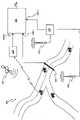
图1综合地表示按照本发明的一个实施例的系统,以及可能的应用情形;Fig. 1 comprehensively represents a system according to an embodiment of the present invention, and possible application scenarios;
图2按照功能块示意性地示出按照本发明的一个实施例的图1的系统的更详细视图;Fig. 2 schematically shows a more detailed view of the system of Fig. 1 according to one embodiment of the present invention in terms of functional blocks;
图3示意性示出按照本发明的一个实施例的数据的表格排列;Fig. 3 schematically shows a tabular arrangement of data according to an embodiment of the present invention;
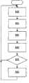
图4按照本发明的一个实施例,示意性示出一种可能的信息处理方法的主要步骤;Fig. 4 schematically shows the main steps of a possible information processing method according to an embodiment of the present invention;
图5按照本发明的一个实施例,示意性示出另一种可能的信息处理方法的主要步骤;Fig. 5 schematically shows the main steps of another possible information processing method according to an embodiment of the present invention;
图6按照本发明的一个实施例,示意性示出另一种可能的信息处理方法的主要步骤;Fig. 6 schematically shows the main steps of another possible information processing method according to an embodiment of the present invention;
图7按照本发明的一个实施例,示意性示出另一种可能的信息处理方法的主要步骤;Fig. 7 schematically shows the main steps of another possible information processing method according to an embodiment of the present invention;
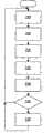
图8按照本发明的一个实施例,示意性示出另一种可能的信息处理方法的主要步骤;Fig. 8 schematically shows the main steps of another possible information processing method according to an embodiment of the present invention;
图9示意性示出在图7的方法中采用的把宏区分成子区的示例性划分;以及Figure 9 schematically illustrates an exemplary division of a macro area into sub-areas employed in the method of Figure 7; and
图10按照本发明的一个实施例,示意性示出另一种可能的信息处理方法的主要步骤。Fig. 10 schematically shows the main steps of another possible information processing method according to an embodiment of the present invention.
具体实施方式Detailed ways
参见附图,在图1中,综合地表示了按照本发明的一个实施例的系统,以及可能的使用情形。Referring to the accompanying drawings, in Fig. 1, a system according to an embodiment of the present invention and a possible usage situation are comprehensively shown.
附图标记105表示路网,它可以是或者可包括城镇的街道、市区外的道路、公路等中的一个或多个。
附图标记110用于表示一个或多个常规的车辆计数系统,比如人工车辆计数系统和/或自动车辆计数系统(例如,使用沿着待监控的道路物理布置的橡胶管,和/或金属线圈和/或视频摄像机的系统)。
附图标记115表示GPS(即,围绕地球运转的一群卫星,和用于其操作的所有地基设备);装备有GPS接收器(为了清楚起见,图中未示出)的车辆可规则地把其位置和速度传送给服务中心120。
附图标记125表示蜂窝PLMN(下面简称为PLMN 125),比如GSM、GPRS、UMTS或等效网络。
方框130图示出按照本发明的一个实施例的估计和/或监视和/或管理道路交通的系统(下面简称为交通监控系统130)。交通监控系统130具有在图中被图示成135-1和135-2的信息输入端,用于从常规的信息源,比如人工和/或自动车辆计数系统115,和从服务中心120接收信息。交通监控系统130具有在图中被图示成135-3的额外信息输入端,用于从PLMN 125接收信息(更一般地说,系统130可从两个或更多的PLMN接收信息)。系统130具有输出端140,在输出端140,可获得道路交通估计和/或监视和/或管理信息。
图2中更详细地表示了按照本发明的实施例的交通监控系统130的结构。按照功能块描述交通监控系统130的结构,每个功能块可用硬件或软件实现,或者可被实现成硬件和软件的混合物。The structure of the
交通监控系统130包含信息输入接口205,信息输入接口205适合于管理来自不同的可能信息源,比如人工和/或自动车辆计数系统110、服务中心120和PLMN 125的信息的接收(在信息输入端135-1,135-2和135-3)。信息输入接口205接收的信息被传给信息数据库管理器210,信息数据库管理器210适合于管理至少临时保存从不同的可能信息源接收的信息的数据库215。数据库管理器210还向信息处理引擎220提供其服务,信息处理引擎220适合于按照由处理引擎220从可用信息处理方法库225中选择的一种或多种信息处理方法,处理来自不同的可能信息源并保存在数据库215中的信息,处理方法的选择是根据预定的选择标准230做出的。还提供用户-机器接口235,以允许系统130与人类用户交互,例如用于向用户提供输出信息,和用于系统管理的目的。The
交通监控系统130在输入端中接收的信息可被分成两类:由常规交通计算系统(“常规交通计算系统”意指人工和/或自动车辆计数系统,比如系统110、基于具有GPS接收器的浮动车的系统115,更一般地说,不同于蜂窝PLMN的系统)提供的信息,和由一个或多个PLMN(比如PLMN 125)提供的信息。The information received in the input by the
第一类信息可包括:The first category of information may include:
-从人工和/或自动车辆计数器得到的信息,该信息是在选择的基准时间单位(例如,15分钟)内通过某一路段的车辆的数目;- information obtained from manual and/or automatic vehicle counters, which is the number of vehicles passing a certain road segment within a selected reference time unit (for example, 15 minutes);
-从浮动车的车载GPS接收器得到的信息,该信息例如由浮动车在移动时获得的一系列地理位置(坐标x,y)和浮动车的相对速度构成。- Information obtained from the on-board GPS receiver of the floating vehicle, which for example consists of a series of geographic positions (coordinates x, y) obtained by the floating vehicle while it is moving and the relative speed of the floating vehicle.
第二类信息可包括:The second category of information may include:
-关于当车辆内的用户的移动终端处于待机状态时,它们所位于的宏区(例如,位置区域或路由区域)的指示;- an indication of the macro area (e.g. location area or routing area) in which users inside the vehicle are located when their mobile terminals are in standby;
-当开始呼叫,发送消息(例如,短消息服务-SMS消息,或者多媒体消息服务-MMS-消息),或者进行切换(服务网络小区改变)时,车辆内的用户的移动终端所位于的网络小区(即,所述移动终端连接到的网络小区)的标识符;- the network cell in which the user's mobile terminal in the vehicle is located when initiating a call, sending a message (eg Short Message Service-SMS message, or Multimedia Message Service-MMS-message), or performing a handover (serving network cell change) (i.e., the identifier of the network cell to which the mobile terminal is connected);
-当开始呼叫,SMS或MMS消息被发送等时,或者当进行切换时,车辆内的用户的移动终端在相应网络小区内的地理位置(坐标x,y);- the geographical position (coordinates x, y) of the mobile terminal of the user in the vehicle within the corresponding network cell when a call is initiated, an SMS or MMS message is sent, etc., or when a handover is performed;
-呼叫期间,车辆内用户的移动终端的完整轨迹,即,借助任何已知或可能的定位技术,以规则的时间间隔测量的移动终端的一系列地理位置(坐标x,y)。- The complete trajectory of the mobile terminal of the user inside the vehicle during the call, ie a series of geographical positions (coordinates x, y) of the mobile terminal measured at regular time intervals by means of any known or possible positioning technique.
更具体地说,在输入端135-1,交通监控系统130能够例如接收下述信息种类:More specifically, at input 135-1,
1)安装人工和/或自动车辆计数器的路段的地理坐标的列表,和由该列表中每个计数器计数的车辆的数目。1) A list of geographical coordinates of road segments where manual and/or automatic vehicle counters are installed, and the number of vehicles counted by each counter in this list.
在输入端135-2,交通监控系统130能够例如收到下述信息:At input 135-2,
2)浮动车的列表,和该列表中的每辆浮动车的完整轨迹,即,借助GPS以规则时间间隔测量的每辆浮动车的一系列地理位置(坐标x,y)。2) A list of floating cars, and the complete trajectory of each floating car in the list, ie, a series of geographic locations (coordinates x, y) of each floating car measured at regular time intervals by means of GPS.
所接收的信息被保存在数据库215中,在数据库215中,最好按照下述中的一个或多个列举相关数据:获得信息所必需的增加的负担(获得信息种类1相比,获得信息种类2的负担更高);信息处理负担,即,用于处理信息以便监视、估计、管理道路交通的信息的计算负担(与处理和信息种类1相关的数据相比,处理与信息种类2相关的数据更复杂);和交通监控系统130能够提供的道路交通监视、估计、管理结果的精度(与当可以获得信息种类1时相比,当可以获得信息种类2时结果的精度更高)。The received information is stored in a
交通监控系统130还能够接收信息种类1)和2)的任何可能的组合,例如,安装人工和/或自动车辆计数器的路段的地理坐标的列表,及由列表中的每个计数器计数的车辆的数目,和浮动车的列表及该列表中的每辆浮动车的完整轨迹。The
在输入端135-3,交通监控系统130能够例如接收下述信息种类:At input 135-3,
3)在被监控路网中移动的车辆内的用户的移动终端的列表,和列表中的每个移动终端所位于的宏区的标识符;宏区标识符可用字母数字代码表示,或者用宏区质心的地理坐标(x,y)表示;3) A list of the mobile terminals of the users in the vehicles moving in the monitored road network, and the identifier of the macro area where each mobile terminal in the list is located; Geographic coordinates (x, y) representation of the centroid;
4)在被监控路网中移动的车辆内的用户的移动终端的列表,和当进行电话呼叫时,或者在发送SMS和/或MMS消息时,或者当进行切换时,所述列表中的每个移动终端所位于的PLMN小区的标识符;小区标识符可用字母数字代码表示,或者用小区质心的地理坐标(x,y)表示;4) A list of mobile terminals of users in vehicles moving in the monitored road network, and when making a phone call, or when sending SMS and/or MMS messages, or when switching, each The identifier of the PLMN cell where the mobile terminal is located; the cell identifier can be represented by an alphanumeric code, or by the geographic coordinates (x, y) of the centroid of the cell;
5)在被监控路网中移动的车辆内的用户的移动终端的列表,和当列表中的每个移动终端进行电话呼叫或切换时,它们在相应PLMN小区内的地理位置(坐标x,y);5) A list of mobile terminals of users in vehicles moving in the monitored road network, and when each mobile terminal in the list makes a phone call or handover, their geographic location (coordinates x, y) in the corresponding PLMN cell ;
6)在被监控路网中移动的车辆内的用户的移动终端的列表,和呼叫期间该列表中的每个移动终端的完整轨迹,即,借助任何已知或可能的定位技术以规则时间间隔测量的移动终端的一系列地理位置(坐标x,y)。6) A list of the mobile terminals of the user in the vehicle moving in the monitored road network, and the complete trajectory of each mobile terminal in this list during the call, i.e. measured at regular time intervals by means of any known or possible positioning technique A series of geographic locations (coordinates x, y) of the mobile terminal.
所接收的信息被保存在数据库215中,在数据库215中,优选地按照下述中的一个或多个列举相关数据:为获得信息而必需的增加的负担(从信息种类3到信息种类6递增);信息处理负担(从信息种类3到信息种类6递增);和交通监控系统130能够提供的道路交通监视、估计、管理结果的精度(从信息种类3到信息种类6递增)。The received information is stored in a
提供的信息的种类可取决于移动终端的特性、取决于网络设备的功能,并且取决于特定的自组织(ad-hoc)设备在PLMN核心网络中的存在。例如,不是所有的移动终端都能够进行其定位所必需的测量(信息种类5和6),不是所有的网络设备都具有在某些情况下定位移动终端所必需的附加功能(信息种类5和6),不是所有的网络设备都能够从通信协议中提取并且向交通监控系统130发送与普通移动终端所位于的宏区或小区有关的信息(信息种类3和4),或者不是所有的PLMN都具有能够使用由移动终端或网络设备进行的测量(信息种类5和6)的定位系统,等等。The kind of information provided may depend on the characteristics of the mobile terminal, on the functionality of the network equipment, and on the presence of certain ad-hoc equipment in the PLMN core network. For example, not all mobile terminals are capable of making the measurements necessary for their location (information categories 5 and 6), and not all network equipment has the additional functionality necessary to locate a mobile terminal in some cases (information categories 5 and 6 ), not all network devices can extract from the communication protocol and send to the
交通监控系统130还可接收信息种类3)、4)、5)和6)中的两个或更多个的任何可能组合。例如,可以获得的其它种类的信息可以是:The
7)移动终端的第一列表(连接到PLMN 125的所有移动终端的第一子集)及所述第一列表中的每个移动终端所位于的宏区的标识符,和移动终端的第二列表(连接到PLMN 125的所有移动终端的第二子集)及当产生呼叫或者进行切换时,所述第二列表中的每个移动终端在相应小区内的地理位置(坐标x,y);7) A first list of mobile terminals (a first subset of all mobile terminals connected to the PLMN 125) and an identifier of the macro area in which each mobile terminal in said first list is located, and a second list of mobile terminals a list (a second subset of all mobile terminals connected to the PLMN 125) and the geographic location (coordinates x, y) of each mobile terminal in the second list within the corresponding cell when a call is made or a handover is performed;
8)移动终端的第三列表(连接到PLMN 125的所有移动终端的第三子集)及所述第三列表中的每个移动终端所位于的宏区的标识符,移动终端的第四列表(连接到PLMN 125的所有移动终端的第四子集)及在进行电话呼叫时,或者在发送SMS或MMS消息时,或者当进行切换时,所述第四列表中的每个移动终端所位于的小区的标识符,移动终端的第五列表(连接到PLMN 125的所有移动终端的第五子集)及当所述第五列表中的每个移动终端进行电话呼叫时,每个移动终端的完整轨迹。8) A third list of mobile terminals (a third subset of all mobile terminals connected to the PLMN 125) and an identifier of the macro area in which each mobile terminal in said third list is located, a fourth list of mobile terminals (the fourth subset of all mobile terminals connected to the PLMN 125) and when making a phone call, or when sending an SMS or MMS message, or when switching, where each mobile terminal in the fourth list is located , the fifth list of mobile terminals (a fifth subset of all mobile terminals connected to the PLMN 125) and when each mobile terminal in said fifth list makes a phone call, the full track.
交通监控系统130可以规则地以离散的时间间隔Δt、或者连续地接收来自不同的可能信息源(人工和/或自动车辆计数系统、浮动车、PLMN)的信息。在连续接收的情况下,交通监控系统130可根据待提供的输出的种类,按时间块组织接收的数据。交通监控系统130可以在某些时间间隔Δt中在任意信息输入端135-1、135-2或135-3上未收到任何信息,例如,它可以未从PLMN 125收到任何信息。当在时间间隔Δt中,一个或多个移动终端改变了宏区,发出多于一个的呼叫,或者进行了多于一次的切换等的情况下,那些移动终端会多次出现在宏区或小区标识符或不同小区的位置的列表中。适合于指示事件(电话呼叫,切换等)发生的时刻的时间指示可与上面提及的每个列表中的每个信息元素相联系。The
交通监控系统130还可使用由不同的车辆交通监控设备,比如使用布置在路网中的固定点的激光器来测量车速的系统提供的信息。The
交通监控系统130适合于处理从不同的信息源接收的信息,以在输出中提供下述中的一个或多个:The
-关于一般路段中存在事故或交通拥堵的指示;- indications regarding the presence of accidents or traffic jams in general road sections;
-沿着被监控路网的所有路段,或者沿着在交通监控系统130的配置阶段中由系统管理员选择的被监控路网中所有路段的子集的平均速度;- the average speed along all road segments of the monitored road network, or along a subset of all road segments in the monitored road network selected by the system administrator during the configuration phase of the
-沿着默认由系统管理员设定或者由交通监控系统130的客户选择或要求的路网上的任意路线(用起点和终点识别的路线)的行程时间;- travel time along any route (route identified with origin and destination) on the road network set by default by the system administrator or selected or requested by the customer of the
-沿着被监控路网的所有路段的车辆流量,或者沿着在系统配置阶段中由系统管理员选择的被监控路网的所有路段的子集的车辆流量;- traffic flow along all road segments of the monitored road network, or along a subset of all road segments of the monitored road network selected by the system administrator during the system configuration phase;
-在默认由系统管理员设定或者由客户选择的起点和终点之间的具有最小行程时间的路线的标识。- Identification of a route with minimum travel time between origin and destination set by default by the system administrator or selected by the customer.
图3按照本发明的一个实施例,示出在数据库215中排列由交通监控系统130在输入端中接收的信息的方式。FIG. 3 shows, according to an exemplary embodiment of the invention, the way in which the information received at the input by the
具体地说,以一个或多个矩阵,比如矩阵305的形式逻辑地组织数据。在矩阵305的第一行中,保存与从常规系统(人和/或自动车辆计数系统、浮动车)接收的信息相关的数据;在所示的例子中,矩阵元素31012(矩阵305的第一行第二列)保存由人工和/或自动车辆计数系统110提供的数据,矩阵元素31013(矩阵305的第一行第三列)保存由浮动车提供的数据,并且矩阵元素31014(矩阵305的第一行第四列)保存与由人工和/或自动车辆计数系统110及浮动车二者提供的组合信息相关的数据(在这些信息源都可用的前提下)。在矩阵305的第一列中,保存与从PLMN 125接收的信息相关的数据;在所示的例子中,矩阵元素31021(矩阵305的第二行第一列)保存与上面说明的信息种类3)相关的数据;在矩阵元素31031(矩阵305的第二行第二列)中,保存与上面说明的信息种类4)相关的数据;在矩阵元素31041(矩阵305的第四行第一列)中,保存与上面说明的信息种类5)相关的数据;在矩阵元素31051(矩阵305的第五行第一列)中,保存与上面说明的信息种类6)相关的数据;在矩阵元素31061(矩阵305的第五行第一列)中,保存与上面说明的信息种类7)的组合相关的数据;在矩阵元素31071(矩阵305的第七行第一列)中,保存与上面说明的信息种类7)的组合相关的数据。Specifically, data is logically organized in one or more matrices, such as matrix 305 . In the first row of matrix 305, data related to information received from conventional systems (human and/or automatic vehicle counting systems, floating cars) are held; in the example shown, matrix elements 31012 (th row second column) holds data provided by manual and/or automatic
矩阵305的类属矩阵元素310ij,其中i=2,…,7,j=2,…,4保存处理引擎20将用于处理保存在相关的矩阵元素3101j和310i1中的数据的相应信息处理方法的标识符。在附图中,这些信息处理方法被表示成a1-a6,b1-b4,和c1-c6。关于可用于处理的特定一组数据调整一般的信息处理方法。信息处理方法的复杂度及随之产生的精度从方法a1到方法c6递增。Generic matrix element 310ij of matrix 305, wherein i=2, .. . , 7, j=2 , . Identifier of the information processing method. In the drawings, these information processing methods are represented as a1-a6, b1-b4, and c1-c6. A general approach to information processing is tuned with respect to a particular set of data available for processing. The complexity and consequent precision of the information processing methods increase from method a1 to method c6.
可以预计,可按其它形式,比如其它矩阵形式排列数据;例如,代替按完整性和处理方法复杂度的升序排列数据,可按照降序排列数据,或者甚至可不对数据以任何特殊方式排序。It is contemplated that the data may be arranged in other formats, such as other matrix formats; for example, instead of sorting the data in ascending order of completeness and processing complexity, the data may be sorted in descending order, or the data may not even be sorted in any particular way.
当只能获得源自可能的信息源任意之一的仅一种输入信息时,处理引擎220自动选择与接收的信息对应的信息处理方法。例如,如果交通监控系统仅接收到信息种类1)和信息种类3),那么处理引擎220自动选择处理方法a1(不存在其它选择)。如果源自可能的信息源之一的信息缺失(至少暂时缺失),例如,源自常规信息源之一,比如人工和/或自动车辆计数系统115的信息,源自服务中心120的信息,或者源自PLMN 125的信息缺失,那么发生相同的情况。When only one kind of input information from any one of possible information sources can be obtained, the
相反,在交通监控系统130可以获得几种信息的情况下,原则上它可使用两种或更多的可能处理方法,处理引擎220可根据预定标准选择要使用的处理方法。例如,系统管理员可定义适合于向每种信息处理方法赋值的函数(成本函数);操作上,处理引擎220选择的信息处理方法将是满足该成本函数的方法。例如,这样的函数可以是下述处理方法选择标准的数值表示。Conversely, where the
-交通监控系统在输出中提供的结果的精度:如果希望在系统提供的结果中获得更高精度,那么处理引擎220在所有可用的处理方法中选择能够提供最精确的结果的方法(而不考虑其它选择因素)。参考图3的矩阵,处理引擎220选择在位于矩阵305的最右侧一列和最下面一行的矩阵元素中识别的处理方法,在所示的例子中,是方法c6(这在矩阵305中数据已按照完整性的升序排列的前提下有效)。事实上,由于一般的PLMN小区覆盖的范围小于宏区覆盖的范围,因此与使用宏区相比,使用PLMN小区来指示移动终端的位置可提供更精确的结果;类似地,与使用PLMN小区的位置相比,使用发生切换的准确位置的信息可提供更精确的结果,依此类推。出于相似的原因,与车辆计数器提供的信息相比,GPS提供更精确的信息。移动终端的位置信息越精确,交通情况的估计就越精确。通常,输出结果的精确性和处理方法之间的关联由系统管理员在配置阶段中产生。- Accuracy of the results provided by the traffic monitoring system in the output: If a higher degree of accuracy is desired in the results provided by the system, the
-应答时间:如果希望减小交通监控系统130提供输出结果所需的时间,那么处理引擎220在所有可用的信息处理方法中选择能够在最短的时间内提供结果的方法,而不考虑其它选择因素。参考图3的矩阵,处理引擎选择在最左侧一列和最高一行的矩阵元素中指示的处理方法,因为随着在矩阵305中向下移动,待处理的数据量增大(例如,与处理单一位置的第三矩阵行中的方法相比,第四矩阵行中的处理方法需要处理整个轨迹,依此类推),从而系统提供输出结果就需要更多的处理时间。另外在这种情况下,应答时间和信息处理方法之间的关联可由系统管理员在配置阶段中产生。- Response time: If it is desired to reduce the time required for the
-输出结果的种类:如果将由交通监控系统提供的输出仅包括在事故或交通拥堵情况下发出的报警,那么使用采用PLMN小区的标识符的知识的信息处理方法,比如方法a3就足够了(为了确定在某一区域交通堵塞并且发出对应的报警,仅使用移动终端所位于的宏区或小区的信息的算法就足够了;轨迹知识会提供更高的精确性,不过有时是多余的)。如果改为希望得到整个路网上车辆流量的有关指示,那么优选的是使用采用移动终端的轨迹知识的处理方法,比如处理方法a6。通常,系统管理员负责建立输出种类和待使用的处理方法之间的关联。- kind of output results: if the output to be provided by the traffic monitoring system consists only of alarms issued in case of accidents or traffic jams, then it is sufficient to use information processing methods using knowledge of identifiers of PLMN cells, such as method a3 (for To determine traffic jams in a certain area and to issue corresponding warnings, an algorithm using only information on the macro or cell in which the mobile terminal is located is sufficient; trajectory knowledge would provide greater accuracy, but is sometimes superfluous). If instead a relevant indication of the vehicle flow on the entire road network is desired, then preferably a processing method using the mobile terminal's trajectory knowledge is used, such as processing method a6. Typically, the system administrator is responsible for establishing the association between the output category and the processing method to be used.
-输出结果的预期接收者:如果输出结果意在向驾驶员提供信息服务,那么使用不是特别精确,但是应答时间快速的处理方法就足够了;如果输出结果改为意在由公共行政部门用于某一区域的公共运输的中长期规划,那么处理引擎220优选选择精确的,即使较慢的处理方法。-Intended recipients of the output: if the output is intended to provide information services to the driver, then it is sufficient to use a processing method that is not particularly precise but has a fast response time; if the output is instead intended to be used by the public administration Medium and long-term planning of public transportation in a certain area, then the
-为交通监控系统提供的服务支付的价格:根据输出结果的精确性,处理时间,需要的输入数据的数量,可对每种处理方法分配成本;处理引擎220也可根据交通监控系统130的订户同意支付的价格选择处理方法。- the price paid for the services provided by the traffic monitoring system: according to the accuracy of the output results, the processing time, the amount of input data required, the cost can be assigned to each processing method; the
也可代替任何其它选择标准,由系统管理员任意选择待使用的信息处理方法。The information processing method to be used may also be arbitrarily selected by the system administrator instead of any other selection criteria.
值得指出的是本发明并不局限于系统管理员采用的任何特定的成本函数。例如,在成本函数表示输出的精确性的情况下,可按照向方法a1赋予值1,向方法c1赋予值2,向方法a2赋予值3等等,直到向方法c6赋予值12的方式设计成本函数。It is worth pointing out that the present invention is not limited to any particular cost function employed by the system administrator. For example, where the cost function represents the accuracy of the output, the cost can be designed in such a way that method a1 is assigned a value of 1, method c1 is assigned a value of 2, method a2 is assigned a value of 3, and so on, until method c6 is assigned a value of 12 function.
本发明的交通监控系统130并不局限于由处理引擎使用的特定信息处理方法。不过,仅仅作为例子,在下面的说明中,将详细说明处理引擎220可为处理保存在数据库215中的信息而选择的一些信息处理方法。The
-第一信息处理方法(方法a1)-First information processing method (method a1)
这种方法使用的输入数据是移动终端的列表以及该列表中的每个移动终端所位于的宏区的标识符,和进行车辆数目的人工和/或自动计数的路段的坐标列表,以及相应的车辆计数。该方法涉及在图4的流程图中图示的下述一系列操作:The input data used by this method is a list of mobile terminals and the identifier of the macro area where each mobile terminal in the list is located, and a list of coordinates of road sections where manual and/or automatic counting of the number of vehicles is performed, and the corresponding Vehicle count. The method involves the following sequence of operations illustrated in the flowchart of Figure 4:
步骤405-在起动之后,系统(在输入端135-3)接收来源于PLMN的信息;Step 405 - after start-up, the system receives (at input 135-3) information originating from the PLMN;
步骤410-系统还(在输入端135-1)从部署在路网上的人工和/或自动计数系统接收关于车辆计数的信息;Step 410 - the system also receives (at input 135-1) information on vehicle counts from manual and/or automatic counting systems deployed on the road network;
步骤415-对于每个宏区i,处理引擎220计算在时间间隔Δt中,位于该宏区中的终端的数目Ni;Step 415 - For each macrozone i, the
步骤420-对于在宏区i的边界的每个路段j,处理引擎220计数进入该宏区的车辆的数目Aej,和离开该宏区的车辆的数目Alj;Step 420—for each road segment j at the border of the macro-area i, the
步骤425-处理引擎220评估终端的数目Ni和公式
步骤430-系统在输出中提供所考虑宏区中交通拥堵的指示,并跳回到开始步骤(步骤405),开始下一时间间隔Δt。Step 430 - The system provides in output an indication of traffic congestion in the considered macro-zone and jumps back to the start step (step 405) to start the next time interval Δt.
-第二信息处理方法(方法a2)- Second information processing method (method a2)
这种方法使用移动终端的列表及当进行呼叫,或者(SMS或MMS)消息被发送等时,或者在发生切换时,列表中的每个移动终端所位于的小区的标识符,和安装人工和/或自动计数系统的路段的坐标列表,以及计数的车辆数目作为输入数据。该方法涉及在图5的流程图中图示的下述一系列操作:This method uses a list of mobile terminals and the identifier of the cell in which each mobile terminal in the list is located when a call is made, or a (SMS or MMS) message is sent, etc., or when a handover occurs, and installation labor and /or a list of coordinates of road segments for automatic counting systems, and the number of counted vehicles as input data. The method involves the following sequence of operations illustrated in the flowchart of Figure 5:
步骤505-在起动之后,系统(在输入端135-3)接收来自PLMN的信息;Step 505 - After startup, the system receives (at input 135-3) information from the PLMN;
步骤510-系统(在输入端135-1)接收来自人工和/或自动计数系统的信息;Step 510 - The system receives (at input 135-1) information from manual and/or automatic counting systems;
步骤515-对于PLMN的每个小区i,处理引擎220计算在所考虑的时间间隔Δt内,位于该小区中的移动终端的数目Ni;Step 515 - for each cell i of the PLMN, the
步骤520-对于位于小区i的边界的每个路段j,处理引擎220计数进入该小区的车辆的数目Aej,和离开该小区的车辆的数目Alj;Step 520 - for each road segment j located on the border of a cell i, the
步骤525-处理引擎评估移动终端的数目Ni和公式
步骤530-系统在输出中提供小区i中交通拥堵的指示,并且方法跳回到开始步骤(步骤505),开始下一时间间隔Δt。Step 530 - The system provides in output an indication of traffic congestion in cell i, and the method jumps back to the start step (step 505), starting the next time interval Δt.
-第三信息处理方法(方法a3)- Third information processing method (method a3)
这种方法使用移动终端的列表及当移动终端发出呼叫或进行切换时,列表中的每个移动终端的地理位置(坐标x,y),和安装人工和/或自动计数系统的路段的坐标列表,以及计数的车辆数目作为输入数据。该方法涉及在图6的流程图中图示的下述一系列操作:This method uses a list of mobile terminals and the geographical location (coordinates x, y) of each mobile terminal in the list when the mobile terminal places a call or makes a handover, and a list of coordinates of road sections where manual and/or automatic counting systems are installed , and the number of counted vehicles as input data. The method involves the following sequence of operations illustrated in the flowchart of Figure 6:
步骤605-在起动之后,系统(在输入端135-3)接收来自PLMN的信息;Step 605 - After start-up, the system receives (at input 135-3) information from the PLMN;
步骤610-系统(在输入端135-1)接收来自人工和/或自动计数系统的信息;Step 610 - The system receives (at input 135-1) information from manual and/or automatic counting systems;
步骤615-处理引擎220把关心的区域分成例如预定大小的正方形的区域单元;Step 615—the
步骤620-对于每个区域单元i,处理引擎220计算在时间间隔Δt内位于其中的移动终端的数目Ni;Step 620 - for each area unit i, the
步骤625-对于位于区域单元i的边界的每个路段j,处理引擎220计数进入该区域单元的车辆的数目Aej,和离开该区域单元的车辆的数目Alj;Step 625 - For each road segment j located on the border of an area unit i, the
步骤630-处理引擎220评估移动终端的数目Ni和公式的结果(进入区域单元的车辆的总数减去离开区域单元的车辆的总数)是否超过相应的预定阈值Si和ΔA;在肯定的情况下,方法进入步骤635,否则方法跳回到开始步骤(步骤605);Step 630 - The
步骤635-系统在输出中提供区域单元i中交通拥堵的指示,并且方法跳回到开始步骤(步骤605),开始下一时间间隔Δt。Step 635 - The system provides in output an indication of traffic congestion in area unit i, and the method jumps back to the start step (step 605) to begin the next time interval Δt.
-第四信息处理方法(方法a4)- Fourth information processing method (method a4)
这种方法使用移动终端的列表及呼叫期间每个移动终端的完整轨迹,和安装人工和/或自动计数系统的路段的坐标列表,以及计数的车辆数目作为输入数据。该方法涉及在图7的流程图中图示的下述一系列操作:This method uses as input data the list of mobile terminals and the complete trajectory of each mobile terminal during the call, and the list of coordinates of road sections where manual and/or automatic counting systems are installed, and the number of vehicles counted. The method involves the following sequence of operations illustrated in the flowchart of Figure 7:
步骤705-在起动之后,系统(在输入端135-3)接收来自PLMN的信息;Step 705 - After start-up, the system receives (at input 135-3) information from the PLMN;
步骤710-系统还(在输入端135-1)接收来自人工和/或自动计数系统的信息;Step 710 - The system also receives (at input 135-1) information from manual and/or automatic counting systems;
步骤715-处理引擎220识别关心的区域内的待监控道路(或路段);Step 715—the
步骤720-对于每个待监控的道路i,处理引擎220计算在时间间隔Δt内位于其中的移动终端的数目Ni;Step 720 - For each road i to be monitored, the
步骤725-对于位于道路i两端的每个路段j,处理引擎220计数进入该道路的车辆的数目Aej,和离开该道路的车辆的数目Alj;Step 725 - For each road segment j located at both ends of the road i, the
步骤730-处理引擎220评估移动终端的数目Ni和公式
步骤735-系统在输出中提供道路i中交通拥堵的指示,并且方法跳回到开始步骤(步骤705),考虑下一时间间隔Δt。Step 735 - The system provides in output an indication of traffic congestion in road i, and the method jumps back to the start step (step 705), considering the next time interval Δt.
在上述任意方法中,两个阈值Si和ΔA的值可由系统管理员设定,或者可由处理引擎220根据持续一段时间对交通的监控,利用预定的经验公式自动计算。此外,在数据库215中存在识别所有道路的坐标的情况下,通过使每条道路和宏区,PLMN小区或者区域单元相联系,能够按单一道路的水平提供关于交通拥堵的信息。In any of the above-mentioned methods, the values of the two thresholds Si and ΔA can be set by the system administrator, or can be automatically calculated by the
仍然作为例子,下面说明计算路段上的平均车速的一些可能方法,这些方法利用来自配备GPS接收器的车辆的信息和来源于PLMN的信息。Still as an example, some possible methods of calculating the average vehicle speed on a road segment using information from a vehicle equipped with a GPS receiver and information originating from the PLMN are described below.
-第六信息处理方法(方法b1)- A sixth information processing method (method b1)
这种方法使用移动终端的列表及列表中的每个移动终端所位于的宏区的标识符,和浮动车,即配备GPS接收器的车辆的列表及每车浮动车的完整轨迹作为输入数据。该方法涉及在图8的流程图中图示的下述一系列操作:This method uses as input data a list of mobile terminals and the identifier of the macrozone where each mobile terminal in the list is located, and floating vehicles, ie a list of vehicles equipped with GPS receivers and the complete trajectory of each floating vehicle. The method involves the following sequence of operations illustrated in the flowchart of Figure 8:
步骤805-在起动之后,系统(在输入端135-3)接收来自PLMN的信息;Step 805 - After startup, the system receives (at input 135-3) information from the PLMN;
步骤810-系统还(在输入端135-2)接收来自浮动车的信息;Step 810 - The system also receives (at input 135-2) information from the floating vehicle;
步骤815-处理引擎220识别浮动车在所考虑的时间间隔Δt内经过的道路或路段;Step 815 - the
步骤820-处理引擎220以浮动车在时间间隔Δt内的速度平均值的形式,计算在该时间间隔内道路i上的平均速度;可根据浮动车的行进感测区分该速度;Step 820 - the
步骤825-处理引擎220把宏区分成一定数目的子区。为了简单起见,细分标准可以是图9中示意描述的细分标准:考虑四个宏区905、910、915和920;子区单元之一用附图标记925识别,是两个区域单元的联合,两个区域单元中的第一个包括宏区905中接近宏区915的一组点,而第二个区域单元是宏区915的接近宏区905的一组点。Step 825 - The
步骤830-处理引擎220识别从浮动车得不到信息,并且地理上包含在指定子区(例如,子区925)中的道路或路段;Step 830—processing
步骤835-处理引擎220关于从宏区905移动到宏区915的每个移动终端,以这两个宏区之间的距离(即,两个基准点,比如宏区的地理质心之间的距离)和移动所用时间(由包括在从PLMN接收的列表中的时刻得到)的比值的形式,计算移动速度vAC。按照类似的方式,处理引擎220计算从宏区915移动到宏区905的移动速度vCA,和移动终端在其它宏区之间移动的移动速度;Step 835 - The
步骤840-处理引擎220通过求在前一步骤中计算的速度的平均值,确定从宏区905到宏区915的平均移动速度vmAC;按照相同的方式,计算从宏区915到宏区905(相反的行进方向)的平均移动速度vmCA;Step 840—the
步骤845-处理引擎220把平均速度值vmAC分配给沿着从宏区905到宏区915的行进方向的属于子区925的所有道路或路段;类似地,平均移动速度vmCA被分配给从宏区915到宏区905的行进方向的道路或路段;Step 845 - The
步骤850-系统在输出中提供计算的道路的速度,并且方法跳回到开始步骤(步骤805),以考虑下一个时间间隔Δt。Step 850 - The system provides in output the calculated speed of the road and the method jumps back to the start step (step 805) to consider the next time interval Δt.
-第七信息处理方法(方法b2)- A seventh information processing method (method b2)
这种方法使用移动终端的列表及在呼叫期间,当发送消息(SMS或SMS)等时,或者在切换时,列表中的每个移动终端位于的网络小区的标识符,和浮动车的列表及浮动车的完整轨迹作为输入数据。该方法的步骤基本上和第六方法(方法b1)的步骤相同,区别在于考虑的是PLMN小区,而不是宏区,并且使用PLMN小区的质心来计算移动终端移动速度。This method uses a list of mobile terminals and the identifier of the network cell in which each mobile terminal in the list is located, during a call, when sending a message (SMS or SMS), etc., or at handover, and a list of floating cars and The complete trajectory of the floating car is taken as input data. The steps of this method are basically the same as the steps of the sixth method (method b1), the difference is that the PLMN cell is considered instead of the macro area, and the centroid of the PLMN cell is used to calculate the moving speed of the mobile terminal.
-第八信息处理方法(方法b3)- Eighth information processing method (method b3)
这种方法使用移动终端的列表及当发出呼叫或者发生切换时,列表中的每个移动终端的地理位置(坐标x,y),和浮动车的列表及浮动车的完整轨迹作为输入数据。该方法的步骤基本上和上面说明的方法b1的步骤相同,关心的区域被细分成例如预定大小的正方形的区域单元,并且在计算从一个区域单元到另一个区域单元的移动速度时,考虑的是车辆的精确位置;换句话说,与上面说明的方法b2相比,考虑的是区域单元,而不是小区;移动终端的地理位置的了解允许把每个移动终端分配给特定区域单元。This method uses a list of mobile terminals and the geographic location (coordinates x, y) of each mobile terminal in the list when a call is placed or a handoff occurs, and a list of floating cars with their complete trajectory as input data. The steps of this method are basically the same as the steps of method b1 explained above, the area of interest is subdivided into, for example, square area units of a predetermined size, and when calculating the moving speed from one area unit to another area unit, consider In other words, in contrast to the method b2 explained above, area units are considered instead of cells; knowledge of the geographical location of the mobile terminals allows the assignment of each mobile terminal to a specific area unit.
-第九信息处理方法(方法b4)- Ninth information processing method (method b4)
该方法使用移动终端的列表及移动终端在呼叫期间的完整轨迹,和浮动车的列表及浮动车的完整轨迹作为输入数据。该方法涉及在图10的流程图中图示的下述下系列操作:The method uses a list of mobile terminals and their complete trajectories during a call, and a list of floating cars and their complete trajectories as input data. The method involves the following sequence of operations illustrated in the flowchart of Figure 10:
步骤1005-在起动之后,系统(在输入端135-3)接收来自PLMN的信息;Step 1005 - After start-up, the system receives (at input 135-3) information from the PLMN;
步骤1010-系统还(在输入端135-2)接收来自浮动车的信息;Step 1010 - The system also receives (at input 135-2) information from the floating vehicle;
步骤1015-处理引擎220识别浮动车在所考虑的时间间隔Δt内经过的道路或路段;Step 1015 - the
步骤1020-处理引擎220以浮动车在时间间隔Δt内的速度的平均值形式,计算在该时间间隔Δt中,属于在前一步骤1015识别的道路或路段的第i条道路上的平均速度;根据浮动车的行进感测,区分计算的平均速度;Step 1020 - the
步骤1025-在没有浮动车经过的道路中,处理引擎220识别可得到其完整轨迹的移动终端已经过的那些道路;Step 1025 - Among the roads where no floating vehicles have passed, the
步骤1030-处理引擎220以移动终端在时间间隔Δt内的速度的平均值形式,计算在该时间间隔Δt中,属于在前一步骤识别的那些道路的道路j上的平均速度;另外这种情况下,根据终端的行进感测,区分计算的平均速度;Step 1030 - the
步骤1035-处理引擎220识别既没有浮动车经过,又没有移动终端经过的剩余道路;Step 1035 - the
步骤1040-处理引擎220通过利用例如关于步骤1015和1020中的道路计算的速度,求两个更靠近道路的速度的平均值,或者把关于与道路k交叉的道路(如果有的话)计算的速度分配给道路k(计算速度的其它方式也是可能的),计算在时间间隔Δt中,属于在前一步骤中识别的一组道路中的道路k上的平均速度;Step 1040 - The
步骤1045-系统在输出中提供道路上的速度,并且方法跳回到开始步骤(步骤1005),开始下一个时间间隔Δt。Step 1045 - The system provides the speed on the road in output and the method jumps back to the start step (step 1005) to start the next time interval Δt.
根据借助上述四种方法任意之一计算的速度,处理引擎220能够得到其它感兴趣的信息,比如:According to the speed calculated by any one of the above four methods, the
-当道路上的速度持续特定时间间隔低于预定阈值时,该道路中交通拥堵的指示;- an indication of traffic congestion in a road when the speed on that road is below a predetermined threshold for a specified time interval;
-作为从保存在数据库215中的坐标得到的道路的长度和道路上的平均速度的比值计算的道路上的行程时间;- the travel time on the road calculated as the ratio of the length of the road obtained from the coordinates stored in the
-作为构成路线的道路的行程时间之和计算的特定路线的行程时间;- the travel time of a particular route calculated as the sum of the travel times of the roads making up the route;
-在连接由系统用户选择的起点和终点的所有路线之中,行程时间最小的路线的标识。- Identification of the route with the smallest travel time among all routes connecting the origin and destination selected by the system user.
如果可以得到道路起点和终点的起点-终点矩阵,那么处理引擎可借助常规的运输工程技术,得到道路上或者路段上的流量。If the start-destination matrix of the start and end points of the road is available, the processing engine can use conventional transportation engineering techniques to obtain the traffic flow on the road or road segment.
与这里说明的本发明的实施例相应的系统可借助任何数据处理系统并且使用任何操作系统(Windows,Linux,Unix,MAC OS)来实现。实现本发明的系统的计算机程序可用任何编程语言,比如表现出良好的编程灵活性,并且在处理速度方面保证良好性能水平的Ansi C++编写;不过也可使用其它编程语言,比如Java,Delphi,VisualBasic。语言Ansi C++的选择是指定的。A system corresponding to the embodiments of the invention described here can be realized by means of any data processing system and using any operating system (Windows, Linux, Unix, MAC OS). The computer program for implementing the system of the present invention can be written in any programming language, such as Ansi C++, which exhibits good programming flexibility and guarantees a good level of performance in terms of processing speed; but other programming languages can also be used, such as Java, Delphi, VisualBasic . The choice of language Ansi C++ is specified.
系统可以和任意地理定位技术一起使用。特别地,系统可以和已知的定位技术,比如UL-TOA、E-OTD、CGI+TA、E-CGI+TA等一起使用。The system can be used with any geolocation technology. In particular, the system can be used with known positioning techniques such as UL-TOA, E-OTD, CGI+TA, E-CGI+TA, etc.
按照本发明的方法和系统可以和用于计数车辆的任何系统一起使用。可以无差别地使用橡胶管、金属线圈、视频摄像机等。The method and system according to the invention can be used with any system for counting vehicles. Rubber tubes, metal coils, video cameras, etc. can be used without distinction.
按照本发明的方法和系统可以无差别地和任何卫星定位系统,尤其是GPS、Galileo、EGNOS、GLONASS、COMPASS等一起使用。The method and system according to the invention can be used indiscriminately with any satellite positioning system, in particular GPS, Galileo, EGNOS, GLONASS, COMPASS, etc.
按照本发明的方法和系统能够利用相似或不同的网络设备,根据相似或不同的核心网络技术,从由相同或不同的电话运营商同时管理的一个或多个PLMN接收信息。The method and system according to the present invention is capable of receiving information from one or more PLMNs managed simultaneously by the same or different telephony operators, using similar or different network equipment, according to similar or different core network technologies.
这里通过给出本发明的一些可能实施例,描述了本发明。本领域的技术人员易于认识到不仅其它可能的实施例是可能的,而且可对所描述的实施例进行一些修改,而不脱离在附加权利要求中限定的保护范围。The invention is described here by giving some possible embodiments of the invention. A person skilled in the art readily realizes that not only other possible embodiments are possible, but also that some modifications can be made to the described embodiments without departing from the scope of protection defined in the appended claims.
Claims (22)
Priority Applications (1)
| Application Number | Priority Date | Filing Date | Title |
|---|---|---|---|
| CN201610262880.9ACN105788262B (en) | 2007-12-20 | 2007-12-20 | The method and system of estimating road traffic |
Applications Claiming Priority (1)
| Application Number | Priority Date | Filing Date | Title |
|---|---|---|---|
| PCT/EP2007/064340WO2009080105A1 (en) | 2007-12-20 | 2007-12-20 | Method and system for estimating road traffic |
Related Child Applications (1)
| Application Number | Title | Priority Date | Filing Date |
|---|---|---|---|
| CN201610262880.9ADivisionCN105788262B (en) | 2007-12-20 | 2007-12-20 | The method and system of estimating road traffic |
Publications (1)
| Publication Number | Publication Date |
|---|---|
| CN101925939Atrue CN101925939A (en) | 2010-12-22 |
Family
ID=39712223
Family Applications (1)
| Application Number | Title | Priority Date | Filing Date |
|---|---|---|---|
| CN2007801022256APendingCN101925939A (en) | 2007-12-20 | 2007-12-20 | Method and system for estimating road traffic |
Country Status (4)
| Country | Link |
|---|---|
| US (1) | US8340718B2 (en) |
| EP (1) | EP2235708B1 (en) |
| CN (1) | CN101925939A (en) |
| WO (1) | WO2009080105A1 (en) |
Cited By (1)
| Publication number | Priority date | Publication date | Assignee | Title |
|---|---|---|---|---|
| CN102592446A (en)* | 2012-03-13 | 2012-07-18 | 北京世纪高通科技有限公司 | Method for computing intercity road travel time by using floating car locating data |
Families Citing this family (80)
| Publication number | Priority date | Publication date | Assignee | Title |
|---|---|---|---|---|
| US6587781B2 (en) | 2000-08-28 | 2003-07-01 | Estimotion, Inc. | Method and system for modeling and processing vehicular traffic data and information and applying thereof |
| US7620402B2 (en) | 2004-07-09 | 2009-11-17 | Itis Uk Limited | System and method for geographically locating a mobile device |
| US8924469B2 (en) | 2008-06-05 | 2014-12-30 | Headwater Partners I Llc | Enterprise access control and accounting allocation for access networks |
| US8725123B2 (en) | 2008-06-05 | 2014-05-13 | Headwater Partners I Llc | Communications device with secure data path processing agents |
| US8275830B2 (en) | 2009-01-28 | 2012-09-25 | Headwater Partners I Llc | Device assisted CDR creation, aggregation, mediation and billing |
| US8406748B2 (en) | 2009-01-28 | 2013-03-26 | Headwater Partners I Llc | Adaptive ambient services |
| US8898293B2 (en) | 2009-01-28 | 2014-11-25 | Headwater Partners I Llc | Service offer set publishing to device agent with on-device service selection |
| US8832777B2 (en) | 2009-03-02 | 2014-09-09 | Headwater Partners I Llc | Adapting network policies based on device service processor configuration |
| US8402111B2 (en) | 2009-01-28 | 2013-03-19 | Headwater Partners I, Llc | Device assisted services install |
| US8250207B2 (en) | 2009-01-28 | 2012-08-21 | Headwater Partners I, Llc | Network based ambient services |
| US8548428B2 (en) | 2009-01-28 | 2013-10-01 | Headwater Partners I Llc | Device group partitions and settlement platform |
| US8340634B2 (en) | 2009-01-28 | 2012-12-25 | Headwater Partners I, Llc | Enhanced roaming services and converged carrier networks with device assisted services and a proxy |
| US8924543B2 (en) | 2009-01-28 | 2014-12-30 | Headwater Partners I Llc | Service design center for device assisted services |
| US8391834B2 (en) | 2009-01-28 | 2013-03-05 | Headwater Partners I Llc | Security techniques for device assisted services |
| US8589541B2 (en) | 2009-01-28 | 2013-11-19 | Headwater Partners I Llc | Device-assisted services for protecting network capacity |
| US8626115B2 (en) | 2009-01-28 | 2014-01-07 | Headwater Partners I Llc | Wireless network service interfaces |
| US8346225B2 (en) | 2009-01-28 | 2013-01-01 | Headwater Partners I, Llc | Quality of service for device assisted services |
| US8635335B2 (en) | 2009-01-28 | 2014-01-21 | Headwater Partners I Llc | System and method for wireless network offloading |
| US11973804B2 (en) | 2009-01-28 | 2024-04-30 | Headwater Research Llc | Network service plan design |
| US10064055B2 (en) | 2009-01-28 | 2018-08-28 | Headwater Research Llc | Security, fraud detection, and fraud mitigation in device-assisted services systems |
| US9706061B2 (en) | 2009-01-28 | 2017-07-11 | Headwater Partners I Llc | Service design center for device assisted services |
| US9955332B2 (en) | 2009-01-28 | 2018-04-24 | Headwater Research Llc | Method for child wireless device activation to subscriber account of a master wireless device |
| US9351193B2 (en) | 2009-01-28 | 2016-05-24 | Headwater Partners I Llc | Intermediate networking devices |
| US10237757B2 (en) | 2009-01-28 | 2019-03-19 | Headwater Research Llc | System and method for wireless network offloading |
| US10783581B2 (en) | 2009-01-28 | 2020-09-22 | Headwater Research Llc | Wireless end-user device providing ambient or sponsored services |
| US10798252B2 (en) | 2009-01-28 | 2020-10-06 | Headwater Research Llc | System and method for providing user notifications |
| US10484858B2 (en) | 2009-01-28 | 2019-11-19 | Headwater Research Llc | Enhanced roaming services and converged carrier networks with device assisted services and a proxy |
| US9755842B2 (en) | 2009-01-28 | 2017-09-05 | Headwater Research Llc | Managing service user discovery and service launch object placement on a device |
| US10779177B2 (en) | 2009-01-28 | 2020-09-15 | Headwater Research Llc | Device group partitions and settlement platform |
| US9578182B2 (en) | 2009-01-28 | 2017-02-21 | Headwater Partners I Llc | Mobile device and service management |
| US9571559B2 (en) | 2009-01-28 | 2017-02-14 | Headwater Partners I Llc | Enhanced curfew and protection associated with a device group |
| US10841839B2 (en) | 2009-01-28 | 2020-11-17 | Headwater Research Llc | Security, fraud detection, and fraud mitigation in device-assisted services systems |
| US9980146B2 (en) | 2009-01-28 | 2018-05-22 | Headwater Research Llc | Communications device with secure data path processing agents |
| US10326800B2 (en) | 2009-01-28 | 2019-06-18 | Headwater Research Llc | Wireless network service interfaces |
| US12166596B2 (en) | 2009-01-28 | 2024-12-10 | Disney Enterprises, Inc. | Device-assisted services for protecting network capacity |
| US10057775B2 (en) | 2009-01-28 | 2018-08-21 | Headwater Research Llc | Virtualized policy and charging system |
| US9253663B2 (en) | 2009-01-28 | 2016-02-02 | Headwater Partners I Llc | Controlling mobile device communications on a roaming network based on device state |
| US8606911B2 (en) | 2009-03-02 | 2013-12-10 | Headwater Partners I Llc | Flow tagging for service policy implementation |
| US8793758B2 (en) | 2009-01-28 | 2014-07-29 | Headwater Partners I Llc | Security, fraud detection, and fraud mitigation in device-assisted services systems |
| US8893009B2 (en) | 2009-01-28 | 2014-11-18 | Headwater Partners I Llc | End user device that secures an association of application to service policy with an application certificate check |
| US9392462B2 (en) | 2009-01-28 | 2016-07-12 | Headwater Partners I Llc | Mobile end-user device with agent limiting wireless data communication for specified background applications based on a stored policy |
| US10248996B2 (en) | 2009-01-28 | 2019-04-02 | Headwater Research Llc | Method for operating a wireless end-user device mobile payment agent |
| US12389218B2 (en) | 2009-01-28 | 2025-08-12 | Headwater Research Llc | Service selection set publishing to device agent with on-device service selection |
| US10264138B2 (en) | 2009-01-28 | 2019-04-16 | Headwater Research Llc | Mobile device and service management |
| US9858559B2 (en) | 2009-01-28 | 2018-01-02 | Headwater Research Llc | Network service plan design |
| US9954975B2 (en) | 2009-01-28 | 2018-04-24 | Headwater Research Llc | Enhanced curfew and protection associated with a device group |
| US10715342B2 (en) | 2009-01-28 | 2020-07-14 | Headwater Research Llc | Managing service user discovery and service launch object placement on a device |
| US11985155B2 (en) | 2009-01-28 | 2024-05-14 | Headwater Research Llc | Communications device with secure data path processing agents |
| US12388810B2 (en) | 2009-01-28 | 2025-08-12 | Headwater Research Llc | End user device that secures an association of application to service policy with an application certificate check |
| US8745191B2 (en) | 2009-01-28 | 2014-06-03 | Headwater Partners I Llc | System and method for providing user notifications |
| US10492102B2 (en) | 2009-01-28 | 2019-11-26 | Headwater Research Llc | Intermediate networking devices |
| US9647918B2 (en) | 2009-01-28 | 2017-05-09 | Headwater Research Llc | Mobile device and method attributing media services network usage to requesting application |
| US10200541B2 (en) | 2009-01-28 | 2019-02-05 | Headwater Research Llc | Wireless end-user device with divided user space/kernel space traffic policy system |
| US9270559B2 (en) | 2009-01-28 | 2016-02-23 | Headwater Partners I Llc | Service policy implementation for an end-user device having a control application or a proxy agent for routing an application traffic flow |
| US9565707B2 (en) | 2009-01-28 | 2017-02-07 | Headwater Partners I Llc | Wireless end-user device with wireless data attribution to multiple personas |
| US9572019B2 (en) | 2009-01-28 | 2017-02-14 | Headwater Partners LLC | Service selection set published to device agent with on-device service selection |
| US12432130B2 (en) | 2009-01-28 | 2025-09-30 | Headwater Research Llc | Flow tagging for service policy implementation |
| US9557889B2 (en) | 2009-01-28 | 2017-01-31 | Headwater Partners I Llc | Service plan design, user interfaces, application programming interfaces, and device management |
| US11218854B2 (en) | 2009-01-28 | 2022-01-04 | Headwater Research Llc | Service plan design, user interfaces, application programming interfaces, and device management |
| US9609510B2 (en) | 2009-01-28 | 2017-03-28 | Headwater Research Llc | Automated credential porting for mobile devices |
| EP2287820A1 (en)* | 2009-07-29 | 2011-02-23 | Universität Duisburg-Essen | An apparatus and method operative for providing traffic information on a traffic area |
| WO2011120193A1 (en)* | 2010-03-31 | 2011-10-06 | Siemens Aktiengesellschaft | Method, system and device for providing traffic information |
| US20130211706A1 (en)* | 2010-08-13 | 2013-08-15 | Wavemarket, Inc. | Systems, methods, and processor readable media for traffic flow measurement |
| US9154826B2 (en) | 2011-04-06 | 2015-10-06 | Headwater Partners Ii Llc | Distributing content and service launch objects to mobile devices |
| CN103136953B (en)* | 2011-12-05 | 2015-05-13 | 北京掌行通信息技术有限公司 | Method used for providing dynamic traffic information service |
| CN103593973B (en)* | 2012-12-18 | 2016-07-06 | 北京科技大学 | A kind of urban road traffic situation assessment system |
| US9207105B2 (en) | 2013-06-26 | 2015-12-08 | Globalfoundries U.S. 2 Llc | System and method for incident detection with spatiotemporal thresholds estimated via nonparametric quantile regression |
| CN104573874A (en)* | 2015-01-26 | 2015-04-29 | 中国联合网络通信集团有限公司 | Bus line planning method and device |
| CN104835320B (en)* | 2015-04-30 | 2017-08-25 | 华南理工大学 | A kind of traffic flow evaluation method based on mobile data |
| EP3335209B1 (en)* | 2015-08-11 | 2019-05-08 | Telecom Italia S.p.A. | Method and system for computing an o-d matrix obtained through radio mobile network data |
| CN105072633B (en)* | 2015-08-28 | 2019-04-30 | 中国联合网络通信集团有限公司 | Method and device for optimizing cell handover sequence |
| CN107924612A (en)* | 2015-08-28 | 2018-04-17 | 日产自动车株式会社 | Detection data collection method and detection data collection device |
| CN106781470B (en)* | 2016-12-12 | 2022-01-28 | 百度在线网络技术(北京)有限公司 | Method and device for processing running speed of urban road |
| US10282656B2 (en)* | 2017-01-11 | 2019-05-07 | Thomas Danaher Harvey | Method and device for detecting unauthorized tranfer between persons |
| US10810481B2 (en)* | 2017-01-11 | 2020-10-20 | Thomas Danaher Harvey | Method and system to count movements of persons from vibrations in a floor |
| WO2021033316A1 (en)* | 2019-08-22 | 2021-02-25 | 日本電信電話株式会社 | Number-of-people estimation device, number-of-people estimation method, and number-of-people estimation program |
| KR20220100964A (en)* | 2020-01-03 | 2022-07-18 | 후아웨이 테크놀러지 컴퍼니 리미티드 | Network entities to support the creation of analytics on mobile networks |
| CN111627207A (en)* | 2020-05-22 | 2020-09-04 | 杭州三一谦成科技有限公司 | A new energy vehicle public service platform |
| IT202100023144A1 (en) | 2021-09-08 | 2023-03-08 | Telecom Italia Spa | METHOD AND SYSTEM FOR GENERING REFERENCE DATA FOR PREDICTING TRAFFIC CONDITIONS, AND METHOD AND SYSTEM FOR PREDICTING TRAFFIC CONDITIONS |
| US20230410643A1 (en)* | 2022-06-17 | 2023-12-21 | Microsoft Technology Licensing, Llc | Selecting traffic algorithms to generate traffic data |
Family Cites Families (11)
| Publication number | Priority date | Publication date | Assignee | Title |
|---|---|---|---|---|
| US5173691A (en) | 1990-07-26 | 1992-12-22 | Farradyne Systems, Inc. | Data fusion process for an in-vehicle traffic congestion information system |
| US5657487A (en)* | 1995-06-05 | 1997-08-12 | Airnet Communications Corporation | Mobile telephone location process making use of handoff data |
| US5732383A (en) | 1995-09-14 | 1998-03-24 | At&T Corp | Traffic information estimation and reporting system |
| NO980890L (en) | 1998-02-27 | 1999-08-30 | Ericsson Telefon Ab L M | Measurement of traffic and transport |
| US6587781B2 (en)* | 2000-08-28 | 2003-07-01 | Estimotion, Inc. | Method and system for modeling and processing vehicular traffic data and information and applying thereof |
| FI114832B (en) | 2001-11-05 | 2004-12-31 | Elisa Matkapuhelinpalvelut Oy | Procedures and systems for collecting traffic data |
| IL150894A0 (en)* | 2002-07-24 | 2003-04-10 | A method for measuring road traffic load based on analyzing cellular communications | |
| WO2007077472A1 (en) | 2005-12-30 | 2007-07-12 | Telecom Italia S.P.A. | System and related method for road traffic monitoring |
| US7831380B2 (en) | 2006-03-03 | 2010-11-09 | Inrix, Inc. | Assessing road traffic flow conditions using data obtained from mobile data sources |
| US7912628B2 (en)* | 2006-03-03 | 2011-03-22 | Inrix, Inc. | Determining road traffic conditions using data from multiple data sources |
| US7908076B2 (en)* | 2006-08-18 | 2011-03-15 | Inrix, Inc. | Representative road traffic flow information based on historical data |
- 2007
- 2007-12-20USUS12/809,008patent/US8340718B2/enactiveActive
- 2007-12-20EPEP07857960.4Apatent/EP2235708B1/enactiveActive
- 2007-12-20CNCN2007801022256Apatent/CN101925939A/enactivePending
- 2007-12-20WOPCT/EP2007/064340patent/WO2009080105A1/enactiveApplication Filing
Cited By (1)
| Publication number | Priority date | Publication date | Assignee | Title |
|---|---|---|---|---|
| CN102592446A (en)* | 2012-03-13 | 2012-07-18 | 北京世纪高通科技有限公司 | Method for computing intercity road travel time by using floating car locating data |
Also Published As
| Publication number | Publication date |
|---|---|
| US20100273491A1 (en) | 2010-10-28 |
| WO2009080105A1 (en) | 2009-07-02 |
| EP2235708B1 (en) | 2014-06-04 |
| EP2235708A1 (en) | 2010-10-06 |
| US8340718B2 (en) | 2012-12-25 |
Similar Documents
| Publication | Publication Date | Title |
|---|---|---|
| CN101925939A (en) | Method and system for estimating road traffic | |
| US6490519B1 (en) | Traffic monitoring system and methods for traffic monitoring and route guidance useful therewith | |
| CA2390352C (en) | Apparatus and methods for providing route guidance for vehicles | |
| EP1297513B1 (en) | Method for route identification of a vehicle | |
| Caceres et al. | Review of traffic data estimations extracted from cellular networks | |
| EP1348208B1 (en) | Traffic monitoring system | |
| US6810321B1 (en) | Vehicle traffic monitoring using cellular telephone location and velocity data | |
| US6879907B2 (en) | Method and system for modeling and processing vehicular traffic data and information and applying thereof | |
| US7885758B2 (en) | GPS-based traffic monitoring system | |
| CN100487750C (en) | Method for obtaining traffic information using billing information of mobile terminal | |
| Janecek et al. | Cellular data meet vehicular traffic theory: location area updates and cell transitions for travel time estimation | |
| CN103544837B (en) | Traffic information estimation method and system combining cross-regional position updating and communication | |
| US20040102893A1 (en) | Traffic monitoring system | |
| KR101506927B1 (en) | System for collecting of traffic information, revision device of valid sampling and method for measurement of each average velocity of group, and recording medium thereof | |
| EP2608181B1 (en) | Method for detecting traffic | |
| EP1733366A1 (en) | System for using cellular phones as traffic probes | |
| CN101933061B (en) | Method and system for determining road traffic jams based on information derived from a plmn | |
| KR101508136B1 (en) | System for collecting of traffic information, revision device of valid sampling and method for revision of valid sampling | |
| CN113901109B (en) | Method for calculating total number of people and time distribution of passenger and truck travel modes on intercity highway | |
| Thajchayapong et al. | Enhanced detection of road traffic congestion areas using cell dwell times | |
| CN106920389B (en) | Traffic condition control method and system based on user telecommunication behaviors | |
| CN105788262B (en) | The method and system of estimating road traffic | |
| KR101776807B1 (en) | System for collecting of traffic information, revision device of valid sampling and method for measurement of velocity, and recording medium thereof | |
| EP4324263A1 (en) | Method for characterization of paths travelled by mobile user terminals | |
| RU2442963C1 (en) | Method of traffic data collection and processing using wlans |
Legal Events
| Date | Code | Title | Description |
|---|---|---|---|
| C06 | Publication | ||
| PB01 | Publication | ||
| C10 | Entry into substantive examination | ||
| SE01 | Entry into force of request for substantive examination | ||
| C12 | Rejection of a patent application after its publication | ||
| RJ01 | Rejection of invention patent application after publication | Application publication date:20101222 |