CN101826100A - Automatic integrated system and method of wide area network (WAN)-oriented multisource emergency information - Google Patents
Automatic integrated system and method of wide area network (WAN)-oriented multisource emergency informationDownload PDFInfo
- Publication number
- CN101826100A CN101826100ACN 201010125185CN201010125185ACN101826100ACN 101826100 ACN101826100 ACN 101826100ACN 201010125185CN201010125185CN 201010125185CN 201010125185 ACN201010125185 ACN 201010125185ACN 101826100 ACN101826100 ACN 101826100A
- Authority
- CN
- China
- Prior art keywords
- data
- information
- integration
- area network
- wide area
- Prior art date
- Legal status (The legal status is an assumption and is not a legal conclusion. Google has not performed a legal analysis and makes no representation as to the accuracy of the status listed.)
- Pending
Links
- 238000000034methodMethods0.000titleclaimsabstractdescription20
- 230000010354integrationEffects0.000claimsabstractdescription91
- 238000006243chemical reactionMethods0.000claimsabstractdescription24
- 238000011068loading methodMethods0.000claimsabstractdescription13
- 238000000605extractionMethods0.000claimsabstractdescription5
- 238000007726management methodMethods0.000claimsdescription28
- 238000013499data modelMethods0.000claimsdescription11
- 238000013075data extractionMethods0.000claimsdescription8
- 230000005540biological transmissionEffects0.000claimsdescription3
- 238000013507mappingMethods0.000claimsdescription3
- 230000009466transformationEffects0.000claimsdescription2
- 238000007596consolidation processMethods0.000claims1
- 239000000284extractSubstances0.000claims1
- 238000012544monitoring processMethods0.000abstractdescription4
- 238000013461designMethods0.000description13
- 239000003795chemical substances by applicationSubstances0.000description8
- 238000010586diagramMethods0.000description8
- 238000011161developmentMethods0.000description7
- XLYOFNOQVPJJNP-UHFFFAOYSA-NwaterSubstancesOXLYOFNOQVPJJNP-UHFFFAOYSA-N0.000description6
- 238000005516engineering processMethods0.000description5
- 230000008569processEffects0.000description5
- 238000004140cleaningMethods0.000description3
- 238000004519manufacturing processMethods0.000description3
- 230000008520organizationEffects0.000description3
- 238000011160researchMethods0.000description3
- 230000009286beneficial effectEffects0.000description2
- 238000001983electron spin resonance imagingMethods0.000description2
- 238000009825accumulationMethods0.000description1
- 238000004458analytical methodMethods0.000description1
- 230000015572biosynthetic processEffects0.000description1
- 238000010276constructionMethods0.000description1
- 230000008878couplingEffects0.000description1
- 238000010168coupling processMethods0.000description1
- 238000005859coupling reactionMethods0.000description1
- 238000011156evaluationMethods0.000description1
- 230000006872improvementEffects0.000description1
- 230000010365information processingEffects0.000description1
- 230000002452interceptive effectEffects0.000description1
- 238000012986modificationMethods0.000description1
- 230000004048modificationEffects0.000description1
- 238000012545processingMethods0.000description1
- 230000004044responseEffects0.000description1
- 230000002123temporal effectEffects0.000description1
- 238000012360testing methodMethods0.000description1
- 238000012546transferMethods0.000description1
- 230000000007visual effectEffects0.000description1
Images


Landscapes
- Information Retrieval, Db Structures And Fs Structures Therefor (AREA)
Abstract
Translated fromChinese
Description
Translated fromChinese技术领域technical field
本发明涉及一种面向广域网的多源应急信息自动整合系统及方法。The invention relates to a wide area network-oriented multi-source emergency information automatic integration system and method.
背景技术Background technique
数据是组成信息的基本元素,各种原始数据的积累与集中是一个组织机构开展业务的底层基础,而这些数据大多数是由各种应用系统所生成的结构化数据。企业的结构化数据存放在各种不同的数据库中,新增加的每个企业应用系统都会带来一系列新的结构化数据。数据整合就是对分散异构的多数据源实现统一的访问,实时地、智能地将有价值的数据传递给分析系统或其他应用系统,进行信息的进一步加工。数据整合的目的是将不同的数据库集成起来,提供一种单一的虚拟数据库,这样就不会出现与核心业务不一致的多个数据库。信息整合已经从组织行为上升到国家信息化发展战略。信息渗透并被应用到社会的各个层面,信息化水平高低已经成为衡量一个国家现代化水平和综合国力的重要标志。Data is the basic element of information. The accumulation and concentration of various raw data is the underlying basis for an organization to conduct business, and most of these data are structured data generated by various application systems. Enterprise structured data is stored in various databases, and each newly added enterprise application system will bring a series of new structured data. Data integration is to achieve unified access to scattered heterogeneous multiple data sources, real-time and intelligently transfer valuable data to analysis systems or other application systems for further processing of information. The purpose of data integration is to integrate different databases and provide a single virtual database, so that there will be no multiple databases inconsistent with the core business. Information integration has risen from organizational behavior to national informatization development strategy. Information penetrates and is applied to all levels of society, and the level of informatization has become an important indicator of a country's modernization level and comprehensive national strength.
信息整合是指运用整合的思想和方法,创造性地对各种信息资源进行优化并按照一定的整合模式将信息资源构造成为一个有机整体,从而更大程度地提升灾害信息资源的整体效能,更加有效地支持特定目标实现的动态过程。信息整合也可以定义为依据信息化发展趋势在一定组织的领导下,实现对信息资源进行序洁化、共享化、协调化,进而拓宽信息资源应用领域和挖掘信息价值的管理过程。Information integration refers to the use of integration ideas and methods to creatively optimize various information resources and construct information resources into an organic whole according to a certain integration mode, thereby improving the overall effectiveness of disaster information resources to a greater extent and making them more effective. A dynamic process that effectively supports the achievement of specific goals. Information integration can also be defined as a management process that realizes orderly cleansing, sharing, and coordination of information resources under the leadership of a certain organization according to the development trend of information technology, and then expands the application field of information resources and taps the value of information.
信息整合的概念,最早来自企业信息化应用,由J Harrington在1973年提出,J Harrington首次提出计算机集成制造(CIM)的概念,即以集成思想为指导,通过信息技术的方法和手段,将企业的生产经营过程有机地整合起来。20世纪90年代,伴随着信息技术的飞速发展、信息系统的广泛使用以及全球化经济环境的逐步形成,在以企业合并、精简规模和电子商务为特征的新经济时代,信息技术已成为推动国家发展和社会进步的最重要的力量之一,以信息整合为特征的集成化信息系统体系结构研究逐渐成为研究热点。The concept of information integration originated from the application of enterprise informatization. It was proposed by J Harrington in 1973. J Harrington first proposed the concept of computer integrated manufacturing (CIM), that is, guided by the idea of integration, through the methods and means of information technology, the enterprise The production and operation process is organically integrated. In the 1990s, with the rapid development of information technology, the widespread use of information systems, and the gradual formation of a globalized economic environment, in the new economic era characterized by business mergers, downsizing and e-commerce, information technology has become a driving force for the country. As one of the most important forces of development and social progress, the research on the integrated information system architecture characterized by information integration has gradually become a research hotspot.
灾害信息与突发事件对社会经济发展提出了挑战,应急管理正逐步成为政府的重要职责,面向应急管理的信息技术体系在突发事件监测监控、预测预警、辅助决策和总体评估等各个环节正发挥着越来越重要的作用。地理信息是整合各种突发事件相关信息的基础和框架,尤其是河流、地名等基础地理信息,不仅成为各专业应急部门在进行信息加载、分析、展示不可缺少的基础性信息资源,而且在跨部门信息互联互通和共享整合应用中起着“桥梁”的作用。Disaster information and emergencies pose challenges to social and economic development. Emergency management is gradually becoming an important responsibility of the government. The information technology system oriented to emergency management is being used in various links such as emergency monitoring and monitoring, forecasting and early warning, auxiliary decision-making and overall evaluation. play an increasingly important role. Geographic information is the basis and framework for integrating information related to various emergencies, especially basic geographic information such as rivers and place names. It has not only become an indispensable basic information resource for professional emergency departments to load, analyze, and display information, but also in Cross-departmental information interconnection and sharing and integration applications play the role of a "bridge".
灾情与突发事件发生后,来自不同应急部门的信息,缺乏统一的规范和数据格式,造成信息共享之间存在“鸿沟”,为部门之间数据共享带来障碍,迫切的需要应急信息自动交换与整合的平台软件来整合这些异构、异地、多源的信息。After disasters and emergencies, information from different emergency departments lacks a unified specification and data format, resulting in a "gap" between information sharing and obstacles to data sharing between departments. There is an urgent need for automatic exchange of emergency information And integrated platform software to integrate these heterogeneous, remote, multi-source information.
地理空间信息在信息资源中占有重要地位,据统计约有80%的信息与地理位置有关。各个空间数据生产单位在数据组织格式上有着各自的数据标准,一个部门的数据拿到另一个部门往往就不能就不能够使用,随着信息化建设的不断提高,这种矛盾越来越突出,空间信息整合的需求也就越来越迫切,需要建立一个“桥梁”连接各个地理空间数据源。面向广域网的多源应急信息自动整合方法实现整合广域网中多源应急信息,以满足应急部门之间信息的快速交换的需求。Geospatial information occupies an important position in information resources. According to statistics, about 80% of the information is related to geographical location. Each spatial data production unit has its own data standards in terms of data organization format. The data of one department is often not available to another department. With the continuous improvement of informatization construction, this contradiction is becoming more and more prominent. The demand for spatial information integration is becoming more and more urgent, and it is necessary to build a "bridge" to connect various geospatial data sources. The multi-source emergency information automatic integration method for wide area network realizes the integration of multi-source emergency information in the wide area network, so as to meet the needs of rapid exchange of information between emergency departments.
空间数据整合属于数据整合的范畴,如何实现异地、异构、多源的空间信息访问和应用问题,一直以来成为研究的热点和难点。在灾情发生时来源与不同部门的应急信息,迫切需要实现快速交换与自动整合。Spatial data integration belongs to the category of data integration. How to realize remote, heterogeneous, and multi-source spatial information access and application has always been a research hotspot and difficulty. When a disaster occurs, there is an urgent need for rapid exchange and automatic integration of emergency information from different sources.
发明内容Contents of the invention
在考虑现有技术存在上述问题的基础上,设计了本发明。本发明的目的在于解决分布式网络环境下跨部门的多源应急信息自动整合问题。On the basis of considering the problems mentioned above in the prior art, the present invention is designed. The purpose of the invention is to solve the problem of automatic integration of cross-departmental multi-source emergency information in a distributed network environment.
为实现上述目的,本发明提供一种面向广域网的多源应急信息自动整合方法,一种面向广域网的多源应急信息自动整合系统,所述系统包括地理空间信息整合模块和运行管理工具模块,其中,所述地理空间信息整合模块集成ETL引擎,并负责地理空间信息的不同类型数据的抽取、转换和装载,从而实现地理空间信息从源数据库到目标数据库的交换和整合;所述运行管理工具模块将所有与地理空间信息整合相关的运行管理功能通过服务调用的方式统一管理,对系统的服务、安全、运行等各环节进行实时监控,对系统运行的关键信息进行记录,对系统的基础性运行资源进行管理。In order to achieve the above object, the present invention provides a method for automatic integration of multi-source emergency information oriented to a wide area network, a system for automatic integration of multi-source emergency information oriented to a wide area network, the system includes a geospatial information integration module and an operation management tool module, wherein , the geospatial information integration module integrates the ETL engine, and is responsible for the extraction, transformation and loading of different types of data of the geospatial information, thereby realizing the exchange and integration of the geospatial information from the source database to the target database; the operation management tool module Unified management of all operation management functions related to geospatial information integration through service calls, real-time monitoring of system services, security, operation and other links, recording key information of system operation, and basic operation of the system resources are managed.
优选的,所述面向广域网的多源应急信息自动整合系统包括有创建任务模块、任务列表模块、系统配置模块,在创建任务模块中,创建来源于广域网的不同部门、不同类型的应急信息,成功创建后任务会加入到任务列表中;任务列表模块进行任务运行状态的控制;系统配置模块,提供远程数据连接、本地数据库配置、以及交换目录设置。Preferably, the wide area network-oriented multi-source emergency information automatic integration system includes a task creation module, a task list module, and a system configuration module. In the task creation module, different departments and different types of emergency information from the wide area network are created, successfully After the task is created, the task will be added to the task list; the task list module controls the task running status; the system configuration module provides remote data connection, local database configuration, and exchange directory settings.
优选的,所述面向广域网的多源应急信息自动整合系统还包括有应急平台,在需要进行应急信息整合的多台应用服务器上部署交换节点,通过数据抽取、数据转换和数据清洗,实现基于广域网的多源应急信息的自动交换与整合,转换结果存储于统一时间参考、逻辑属性和空间参照的应急平台数据中心的数据库中。Preferably, the wide area network-oriented multi-source emergency information automatic integration system also includes an emergency platform, where switching nodes are deployed on multiple application servers that need to integrate emergency information, and through data extraction, data conversion and data cleaning, the wide area network-based The automatic exchange and integration of multi-source emergency information, and the conversion results are stored in the database of the emergency platform data center with unified time reference, logical attributes and spatial reference.
优选的,所述应急平台包括数据资源接入层、空间数据整合平台、数据发布与服务层和应用层,通过空间数据整合平台实现地理空间信息基于网络的自动传输、加载与整合,形成参照一致、格式统一、内容完备的应急平台地理空间信息整合数据库。Preferably, the emergency response platform includes a data resource access layer, a spatial data integration platform, a data release and service layer, and an application layer, through which the spatial data integration platform realizes automatic network-based transmission, loading, and integration of geospatial information to form a consistent reference , unified format, and complete emergency platform geospatial information integration database.
优选的,所述地理空间信息整合模块具有Casm.Base,Casm.Data.Trans,File2db,FileGrabber,其中,Casm.Base是多源数据模型的基类,该基类定义了ETL引擎所能识别的典型数据模型,Casm.Data.Trans完成数据格式的转换,File2db实现将转换得到的文件统一录入到相应数据库中,FileCrabber负责远程数据获取。Preferably, said geospatial information integration module has Casm.Base, Casm.Data.Trans, File2db, FileGrabber, wherein, Casm.Base is the base class of multi-source data model, and this base class defines the ETL engine can recognize Typical data model, Casm.Data.Trans completes the conversion of data format, File2db implements the unified entry of converted files into the corresponding database, and FileCrabber is responsible for remote data acquisition.
优选的,所述运行管理工具模块包括有AgentViewer、TaskManager、以及MainApp,其中,AgentViewer是运行界面相关操作类,TaskManager实现任务运行状态的管理和控制,MainApp是运行管理工具的主控制模块。Preferably, the operation management tool module includes AgentViewer, TaskManager, and MainApp, wherein AgentViewer is a related operation class of the operation interface, TaskManager realizes the management and control of task operation status, and MainApp is the main control module of the operation management tool.
另外,提供一种面向广域网的多源应急信息自动整合系统的整合方法,所述整合方法包括地理信息数据抽取阶段、数据转换阶段、以及数据装载阶段;其中在地理信息数据抽取阶段,源数据库中符合条件的地理空间信息被提取出来;在数据转换阶段,提取出的地理空间信息按照指定的映射模型被转换为指定参照格式和模型的地理信息;在数据装载阶段,经转换后的地理空间信息被装入指定的目标数据库。In addition, an integration method of a wide area network-oriented multi-source emergency information automatic integration system is provided, the integration method includes a geographic information data extraction stage, a data conversion stage, and a data loading stage; wherein in the geographic information data extraction stage, the source database The qualified geospatial information is extracted; in the data conversion stage, the extracted geospatial information is converted into the geographic information of the specified reference format and model according to the specified mapping model; in the data loading stage, the converted geospatial information is loaded into the specified target database.
优选的,所述整合方法在广域网中的各个节点上分布进行,并接受人工干预。Preferably, the integration method is distributed on each node in the wide area network and accepts manual intervention.
附图说明Description of drawings
图1是根据本发明的面向广域网的多源应急信息自动整合系统的ETL引擎模型图;Fig. 1 is the ETL engine model figure of the multi-source emergency information automatic integration system facing wide area network according to the present invention;
图2是根据本发明的面向广域网的多源应急信息自动整合系统的地理空间信息整合模块运行示意图;2 is a schematic diagram of the operation of the geospatial information integration module of the wide area network-oriented multi-source emergency information automatic integration system of the present invention;
图3是根据本发明的面向广域网的多源应急信息自动整合系统的功能模块图;Fig. 3 is the functional block diagram of the multi-source emergency information automatic integration system facing wide area network according to the present invention;
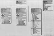
图4a-4c是根据本发明的面向广域网的多源应急信息自动整合系统的地理空间信息整合模块的类图;4a-4c are class diagrams of the geospatial information integration module of the wide area network-oriented multi-source emergency information automatic integration system according to the present invention;
图5是根据本发明的面向广域网的多源应急信息自动整合系统的运行管理工具模块的类图;Fig. 5 is the class diagram of the operation management tool module of the wide area network-oriented multi-source emergency information automatic integration system according to the present invention;
图6是根据本发明的面向广域网的多源应急信息自动整合系统的数据整合平台示意图。Fig. 6 is a schematic diagram of a data integration platform of the wide area network-oriented multi-source emergency information automatic integration system according to the present invention.
具体实施方式Detailed ways
为使本发明的上述目的、特征和优点能够更加明显易懂,下面结合附图和具体实施方式对本发明作进一步详细的说明。In order to make the above objects, features and advantages of the present invention more comprehensible, the present invention will be further described in detail below in conjunction with the accompanying drawings and specific embodiments.
根据本发明的面向广域网的多源应急信息自动整合系统包括地理空间信息整合模块和运行管理工具模块。The wide area network-oriented multi-source emergency information automatic integration system according to the present invention includes a geospatial information integration module and an operation management tool module.
其中,地理空间信息整合模块集成ETL引擎,该模块的设计采用面向对象编程思想,设计有Casm.Base,Casm.Data.Trans,File2db,FileGrabber等类,分别负责不同类型数据的抽取、转换和装载。其中,Casm.Base是多源数据模型的基类,其中定义了ETL引擎所能识别的典型数据模型,Casm.Data.Trans完成数据格式的转换,File2db实现将转换得到的文件统一录入到应急中心数据库中,FileCrabber负责远程数据获取,数据源可以是Http网址、FTP远程文件、本地目录、本地文件、SQL数据库、Oracle数据库。Among them, the geospatial information integration module integrates the ETL engine. The design of this module adopts the idea of object-oriented programming, and the design includes classes such as Casm.Base, Casm.Data.Trans, File2db, and FileGrabber, which are respectively responsible for the extraction, conversion and loading of different types of data. . Among them, Casm.Base is the base class of the multi-source data model, which defines the typical data model that can be recognized by the ETL engine, Casm.Data.Trans completes the conversion of the data format, and File2db implements the unified entry of the converted files into the emergency center In the database, FileCrabber is responsible for remote data acquisition, and the data source can be Http URL, FTP remote file, local directory, local file, SQL database, or Oracle database.
图1是根据本发明的面向广域网的多源应急信息自动整合系统的ETL引擎模型图。Fig. 1 is a diagram of an ETL engine model of a multi-source emergency information automatic integration system oriented to a wide area network according to the present invention.
如图1所示,面向广域网的多源应急信息自动整合系统采用基于ETL的数据整合引擎。ETL(Extract-Transfer-Load,即数据抽取-转换-装载)模型较好地解决了异地、多源、异构地理空间信息的访问和应用问题。在地理信息数据抽取阶段,源数据库中符合条件的地理空间信息被提取出来;在数据转换阶段,提取出的地理空间信息按照指定的映射模型被转换为指定参照格式和模型的地理信息;在数据装载阶段,经转换后的地理空间信息被装入指定的目标数据库,该过程实现了地理空间信息从源数据库到目标数据库的交换和整合,在广域网中的各个节点上分布进行,也可接受人工干预。As shown in Figure 1, the multi-source emergency information automatic integration system for wide area network adopts ETL-based data integration engine. The ETL (Extract-Transfer-Load, that is, data extraction-transfer-loading) model better solves the access and application problems of remote, multi-source, and heterogeneous geospatial information. In the geographic information data extraction stage, the qualified geographic spatial information in the source database is extracted; in the data conversion stage, the extracted geographic spatial information is converted into geographic information in the specified reference format and model according to the specified mapping model; In the loading stage, the converted geospatial information is loaded into the designated target database. This process realizes the exchange and integration of geospatial information from the source database to the target database. It is distributed on each node in the wide area network, and manual intervene.
另外,如图2所示,地理空间信息整合模块包括数据格式转换、空间参照与投影坐标体系变换、空间数据模型变换与数据清洗等功能,支持常规空间数据如Shapefile文件(ESRI)、Coverage文件(ESRI)等、非空间数据如文本文件、Excel表格、DBF文件、数据库、在线数据服务等,通过相应格式适配器模块进行识别,利用模式适配器进行转换,使其具有统一空间参照、时间参照和逻辑属性。在图2中,源数据可以是上述常规空间数据或上述非空间数据,所述源数据经过ETL数据整合引擎1的整合,变换为具有统一空间参照、时间参照和逻辑属性的目标数据。所述ETL数据整合引擎1包括适配器模块2以及数据转换模块3。所述适配器模块2包括与需转换源数据对应的适配器,比如与Shapefile对应的Shapefile适配器,与Coverage对应的Coverage适配器,与DBF对应的DBF适配器,与数据库对应的数据库适配器等等。数据转换模块3包括数据清洗器、空间参照与投影转换器、逻辑属性转换器、以及空间数据模型转换器。In addition, as shown in Figure 2, the geospatial information integration module includes functions such as data format conversion, spatial reference and projected coordinate system conversion, spatial data model conversion and data cleaning, and supports conventional spatial data such as Shapefile files (ESRI), Coverage files ( ESRI), etc., non-spatial data such as text files, Excel tables, DBF files, databases, online data services, etc., are identified through the corresponding format adapter module, converted by the mode adapter, so that they have unified spatial reference, time reference and logical attributes . In FIG. 2 , the source data can be the above-mentioned conventional spatial data or the above-mentioned non-spatial data, and the source data is integrated by the ETL
运行管理工具模块将所有与地理空间信息整合相关的运行管理功能通过服务调用的方式统一管理起来,对系统的服务、安全、运行等各环节进行实时监控,对系统运行的关键信息进行记录,对系统的基础性运行资源进行管理。The operation management tool module manages all the operation management functions related to the integration of geospatial information through service calls, monitors the service, security, and operation of the system in real time, and records the key information of the system operation. The basic operating resources of the system are managed.
根据本发明的面向广域网的多源应急信息自动整合系统是针对广域网中来自多个应急部门的灾情信息实现自动交换与整合,主要用于各个应急信息处理部门。根据应急信息部门的需求,系统可以实现来自水利部门的江河水情信息、水库水情信息、气象部门的气象信息的自动交换与整合。The wide area network-oriented multi-source emergency information automatic integration system of the present invention is aimed at realizing automatic exchange and integration of disaster information from multiple emergency departments in the wide area network, and is mainly used for each emergency information processing department. According to the needs of the emergency information department, the system can realize the automatic exchange and integration of river water regime information, reservoir water regime information from the water conservancy department, and meteorological information from the meteorological department.
如图3所示,所述面向广域网的多源应急信息自动整合系统包括三个功能模块,即创建任务、任务列表、系统配置。在创建任务模块中,用户可以创建来源于广域网的不同部门、不同类型的应急信息,成功创建后任务会加入到任务列表中;任务列表可以进行任务运行状态的控制,包括启动、暂停、停止、删除;系统配置功能模块,提供远程数据连接、本地数据库配置、交换目录设置等内容。As shown in FIG. 3 , the wide area network-oriented multi-source emergency information automatic integration system includes three functional modules, namely task creation, task list, and system configuration. In the task creation module, users can create different types of emergency information from different departments in the WAN. After successful creation, the task will be added to the task list; the task list can control the task running status, including start, pause, stop, Delete; system configuration function module, providing remote data connection, local database configuration, exchange directory settings, etc.
本发明的软件设计遵循国家相关技术标准和软件工程有关规范,系统体系架构清晰合理,具有较高的扩展性。设计中以MVC(Model-View-Control,模型-视图-控制)设计模式为指导,以“高内聚、低耦合”为开发原则,软件各个功能模块均经过严格单元测试,确保软件质量。核心ETL引擎具有较高的匹配效率,并提供对外二次开发接口,便于集成到其他应用系统中。The software design of the present invention complies with relevant national technical standards and relevant software engineering norms, the system architecture is clear and reasonable, and has high expansibility. The design is guided by the MVC (Model-View-Control, Model-View-Control) design pattern, and the development principle is "high cohesion, low coupling". Each functional module of the software has undergone strict unit testing to ensure software quality. The core ETL engine has high matching efficiency, and provides an external secondary development interface for easy integration into other application systems.
地理空间信息整合模块是面向广域网的多源应急信息自动整合软件的核心部分。地理空间信息整合模块集成ETL引擎,该模块的设计采用面向对象编程思想,设计有Casm.Base,Casm.Data.Trans,File2db,FileGrabber等类,分别负责不同类型数据的抽取、转换和装载。其中,Casm.Base是多源数据模型的基类,其中定义了ETL引擎所能识别的典型数据模型;Casm.Data.Trans完成数据格式的转换,该类库实现多种不同格式转换成统一格式的过程;File2db实现将转换得到的文件统一录入到应急中心数据库中,该类库中ParseDBF类负责读取DBF类型的属性文件,SqlConn是对应急数据库进行连接与操作,File2dbAgent是对江河水情和河道水情任务的抽象描述,其子类Sk2Db类用于将水库水情数据录入到应急数据库中、子类Hd2Db类完成河道水情数据的录入;FileCrabber类库负责数据获取包括本地数据获取和远程数据抽取,数据源可以是Http网址、FTP远程文件、本地目录、本地文件、SQL数据库、Oracle数据库,设计中将多源数据抽象为URL资源,DirectoryURL、FileURL、MsdbURL是URL资源的子类,代表目录资源、文件资源和数据库资源。The geospatial information integration module is the core part of the wide area network-oriented multi-source emergency information automatic integration software. The geospatial information integration module integrates the ETL engine. The design of this module adopts the idea of object-oriented programming, and the design includes classes such as Casm.Base, Casm.Data.Trans, File2db, and FileGrabber, which are respectively responsible for the extraction, conversion and loading of different types of data. Among them, Casm.Base is the base class of the multi-source data model, which defines the typical data model that can be recognized by the ETL engine; Casm.Data.Trans completes the conversion of data formats, and this class library realizes the conversion of multiple different formats into a unified format The process; File2db realizes the uniform entry of converted files into the emergency center database. The ParseDBF class in this class library is responsible for reading the attribute file of DBF type. SqlConn is used to connect and operate the emergency database. The abstract description of the river water regime task, its subclass Sk2Db class is used to enter the reservoir water regime data into the emergency database, and the subclass Hd2Db class completes the input of river channel water regime data; the FileCrabber class library is responsible for data acquisition, including local data acquisition and remote Data extraction, the data source can be Http website, FTP remote file, local directory, local file, SQL database, Oracle database, multi-source data is abstracted into URL resources in the design, DirectoryURL, FileURL, MsdbURL are subclasses of URL resources, representing Directory resources, file resources, and database resources.
地理空间信息整合模块中任务的管理采用基于Agent代理的模式来实现,每一个任务都可以看作是一个Agent的实例,实现对Agent的分布式调度与运行状态管理。软件可以利用交互式菜单快速创建任务,包括任务运行的周期、频率和运行参数。软件Agent与其他软件技术相比具有如下优点:(1)系统的数据、控制、专家知识和资源可以分布存储处理。(2)对Agent组成的系统可以进行自然的描述,有利于各有关人员对软件系统的理解。(3)Agent软件系统具有灵活性,有利于现有软件的集成。(4)具有开放性和复杂性。The management of tasks in the geospatial information integration module is realized by the agent-based mode, and each task can be regarded as an instance of Agent, which realizes the distributed scheduling and operation state management of Agent. The software can use the interactive menu to quickly create tasks, including the period, frequency and operating parameters of task operation. Compared with other software technologies, software Agent has the following advantages: (1) The data, control, expert knowledge and resources of the system can be stored and processed in a distributed manner. (2) The system composed of Agent can be described naturally, which is beneficial to the understanding of the software system by all relevant personnel. (3) The Agent software system has flexibility, which is beneficial to the integration of existing software. (4) Openness and complexity.
在设计上,TransAgentMeta类是对Agent的元数据描述,包括任务的名称、描述、创建时间、版本等信息;AgentGroup是Agent实例的集合及对集合的操作,例如增加、移出、清空;AgentManager类实现对Agent的创建、调度、销毁等操作,该类是负责对Agent实例进行管理,包括全部启动、全部暂停、移出某任务等。In terms of design, the TransAgentMeta class is the metadata description of the Agent, including the name, description, creation time, version and other information of the task; the AgentGroup is the collection of Agent instances and the operations on the collection, such as adding, removing, and clearing; the AgentManager class implements For operations such as creating, scheduling, and destroying Agents, this class is responsible for managing Agent instances, including starting all, suspending all, and removing a certain task.
关于地理空间信息整合模块的详细设计部分类图如图4a至4c所示。The class diagrams of the detailed design of the geospatial information integration module are shown in Figures 4a to 4c.
运行管理工具模块,将所有与地理空间信息整合相关的运行管理功能通过服务调用的方式统一管理起来,该模块的设计采用面向对象编程思想和MVC设计模式为指导来实现。其中,AgentViewer是运行界面相关操作类,TaskManager实现任务运行状态的管理和控制,MainApp是运行管理工具的主程序。The operation management tool module manages all operation management functions related to geospatial information integration through service calls. The design of this module is implemented under the guidance of object-oriented programming ideas and MVC design patterns. Among them, AgentViewer is the operation class related to the operation interface, TaskManager realizes the management and control of the task operation state, and MainApp is the main program of the operation management tool.
在设计上,MainApp类是运行管理工具的主界面,它采用Office2007的界面风格,美观且操作方便;AgentViewer控件继承自UserControl控件,控件中包含菜单、列表、树、状态栏等其他基础控件,该控件是用户操作的界面,具有创建任务、任务列表、系统配置等子界面,界面设计美观,易操作性强,便于用户对任务的管理;TaskManager类继承自Form类,是AgentViewer控件中的子控件,利用列表的形式实现对任务的可视化调度,包括任务的启动、暂停、删除、全部启动、全部暂停、全部删除、任务描述查询等,列表中有包括序号、任务名称、当前状态和描述信息在内的内容,便于用户了解任务运行的详细情况。其相关部分设计类图如5所示。In terms of design, the MainApp class is the main interface of the operation management tool. It adopts the interface style of Office2007, which is beautiful and easy to operate; the AgentViewer control inherits from the UserControl control, which includes menus, lists, trees, status bars and other basic controls. The control is an interface operated by the user. It has sub-interfaces such as task creation, task list, and system configuration. , use the form of a list to realize the visual scheduling of tasks, including task start, pause, delete, all start, all pause, all delete, task description query, etc. The list includes serial number, task name, current status and description information. The content in it is convenient for the user to know the details of the task running. The design class diagram of relevant parts is shown in Figure 5.
所述面向广域网的多源应急信息自动整合系统还包括有应急平台。如图6所示,在实际应用中,在多台应用服务器上部署交换节点,通过数据抽取、数据转换和数据清洗,实现基于广域网的多源应急信息的自动交换与整合,转换结果存储于统一时间参考、逻辑属性和空间参照的应急平台数据中心的数据库。The wide area network-oriented multi-source emergency information automatic integration system also includes an emergency platform. As shown in Figure 6, in practical applications, switch nodes are deployed on multiple application servers, and the automatic exchange and integration of multi-source emergency information based on the wide area network is realized through data extraction, data conversion and data cleaning, and the conversion results are stored in the unified A database of emergency platform data centers for temporal references, logical attributes, and spatial references.
应急平台由数据资源接入层、空间数据整合平台、数据发布与服务层和应用层四部分组成。通过空间数据整合平台实现多部门和受灾地区应急地理空间信息基于网络的自动传输、加载与整合,形成参照一致、格式统一、内容完备的应急平台地理空间信息整合数据库,为应急服务决策提供有力的辅助工具。平台在应急地理信息集成发布中发挥了显著作用。The emergency platform consists of four parts: data resource access layer, spatial data integration platform, data publishing and service layer, and application layer. Through the spatial data integration platform, the network-based automatic transmission, loading and integration of emergency geospatial information of multiple departments and disaster-stricken areas can be realized, and an emergency platform geospatial information integration database with consistent reference, unified format and complete content can be formed to provide a powerful basis for emergency service decision-making. Auxiliary tools. The platform has played a significant role in the integrated release of emergency geographic information.
尽管已示出和描述了本发明的优选实施例,可以设想,本领域的技术人员可在所附权利要求的精神和范围内设计对本发明的各种修改。While a preferred embodiment of the invention has been shown and described, it is contemplated that various modifications of the invention can be devised by those skilled in the art within the spirit and scope of the appended claims.
Claims (9)
Priority Applications (1)
| Application Number | Priority Date | Filing Date | Title |
|---|---|---|---|
| CN 201010125185CN101826100A (en) | 2010-03-16 | 2010-03-16 | Automatic integrated system and method of wide area network (WAN)-oriented multisource emergency information |
Applications Claiming Priority (1)
| Application Number | Priority Date | Filing Date | Title |
|---|---|---|---|
| CN 201010125185CN101826100A (en) | 2010-03-16 | 2010-03-16 | Automatic integrated system and method of wide area network (WAN)-oriented multisource emergency information |
Publications (1)
| Publication Number | Publication Date |
|---|---|
| CN101826100Atrue CN101826100A (en) | 2010-09-08 |
Family
ID=42690018
Family Applications (1)
| Application Number | Title | Priority Date | Filing Date |
|---|---|---|---|
| CN 201010125185PendingCN101826100A (en) | 2010-03-16 | 2010-03-16 | Automatic integrated system and method of wide area network (WAN)-oriented multisource emergency information |
Country Status (1)
| Country | Link |
|---|---|
| CN (1) | CN101826100A (en) |
Cited By (18)
| Publication number | Priority date | Publication date | Assignee | Title |
|---|---|---|---|---|
| CN102325170A (en)* | 2011-08-24 | 2012-01-18 | 无锡中科方德软件有限公司 | Data extraction and integration method and system thereof |
| CN102737086A (en)* | 2012-01-13 | 2012-10-17 | 冶金自动化研究设计院 | Iron and steel enterprise information integration platform based on CIM model |
| CN104361086A (en)* | 2014-11-14 | 2015-02-18 | 国电南瑞科技股份有限公司 | Data integration method for measurable asset entire life-cycle management system |
| CN105740251A (en)* | 2014-12-08 | 2016-07-06 | Tcl集团股份有限公司 | Method and system for integrating different content sources in bus manner |
| CN106095953A (en)* | 2016-06-13 | 2016-11-09 | 西安数驰信息科技有限公司 | A kind of real estate data integration method based on GIS |
| CN106708993A (en)* | 2016-12-16 | 2017-05-24 | 武汉中地数码科技有限公司 | Spatial data storage processing middleware framework realization method based on big data technology |
| CN106855962A (en)* | 2015-12-09 | 2017-06-16 | 星际空间(天津)科技发展有限公司 | A kind of method for building government affairs big data platform |
| CN106886535A (en)* | 2015-12-16 | 2017-06-23 | 大唐软件技术股份有限公司 | A kind of data pick-up method and apparatus for being adapted to multiple data sources |
| CN107545046A (en)* | 2017-08-17 | 2018-01-05 | 北京奇安信科技有限公司 | A kind of fusion method and device of multi-source heterogeneous data |
| CN107844538A (en)* | 2017-10-19 | 2018-03-27 | 武汉大学 | Towards the synthetic disaster prevention layout data management system and method in mountain area villages and small towns |
| CN107920126A (en)* | 2017-11-30 | 2018-04-17 | 河南云保遥感科技有限公司 | Big data management method between a kind of distributed space under cloud environment |
| CN107992987A (en)* | 2016-10-26 | 2018-05-04 | 上海仪电(集团)有限公司中央研究院 | A kind of smart city application collection system for unified management and method |
| CN108228021A (en)* | 2016-12-15 | 2018-06-29 | 上海仪电(集团)有限公司中央研究院 | More applying based on smart city operating system can towed integrated system and method |
| CN109408045A (en)* | 2018-11-08 | 2019-03-01 | 国久大数据有限公司 | Government system integration method and device |
| CN109684428A (en)* | 2018-12-12 | 2019-04-26 | 广东启慧城市信息有限公司 | Spatial data building method, device, equipment and storage medium |
| CN111159265A (en)* | 2019-12-03 | 2020-05-15 | 武汉达梦数据库有限公司 | ETL data migration method and system |
| CN112765254A (en)* | 2021-04-08 | 2021-05-07 | 北京三维天地科技股份有限公司 | Solution method and system for realizing data visualization and data integration ETL |
| CN115378937A (en)* | 2022-08-10 | 2022-11-22 | 北京友友天宇系统技术有限公司 | Distributed concurrency method, device and equipment for tasks and readable storage medium |
Citations (3)
| Publication number | Priority date | Publication date | Assignee | Title |
|---|---|---|---|---|
| TWI284864B (en)* | 2002-10-16 | 2007-08-01 | Far Eastone Telecomm Co Ltd | Geography disaster monitoring and alarm system utilizing communication network |
| CN101295172A (en)* | 2008-05-12 | 2008-10-29 | 福建省电力有限公司 | Comprehensive Disaster Prevention and Mitigation System of Power Grid Based on GIS |
| JP2009211576A (en)* | 2008-03-06 | 2009-09-17 | Mitsubishi Electric Corp | Information integrated-processing device |
- 2010
- 2010-03-16CNCN 201010125185patent/CN101826100A/enactivePending
Patent Citations (3)
| Publication number | Priority date | Publication date | Assignee | Title |
|---|---|---|---|---|
| TWI284864B (en)* | 2002-10-16 | 2007-08-01 | Far Eastone Telecomm Co Ltd | Geography disaster monitoring and alarm system utilizing communication network |
| JP2009211576A (en)* | 2008-03-06 | 2009-09-17 | Mitsubishi Electric Corp | Information integrated-processing device |
| CN101295172A (en)* | 2008-05-12 | 2008-10-29 | 福建省电力有限公司 | Comprehensive Disaster Prevention and Mitigation System of Power Grid Based on GIS |
Non-Patent Citations (1)
| Title |
|---|
| 《地理信息世界》 20081231 蒲鹏先 应急地理信息整合平台系统架构初探 39-44 第6卷, 第6期* |
Cited By (24)
| Publication number | Priority date | Publication date | Assignee | Title |
|---|---|---|---|---|
| CN102325170B (en)* | 2011-08-24 | 2014-06-11 | 无锡中科方德软件有限公司 | Data extraction and integration method and system thereof |
| CN102325170A (en)* | 2011-08-24 | 2012-01-18 | 无锡中科方德软件有限公司 | Data extraction and integration method and system thereof |
| CN102737086B (en)* | 2012-01-13 | 2015-06-03 | 冶金自动化研究设计院 | Iron and steel enterprise information integration platform based on CIM model |
| CN102737086A (en)* | 2012-01-13 | 2012-10-17 | 冶金自动化研究设计院 | Iron and steel enterprise information integration platform based on CIM model |
| CN104361086A (en)* | 2014-11-14 | 2015-02-18 | 国电南瑞科技股份有限公司 | Data integration method for measurable asset entire life-cycle management system |
| CN105740251B (en)* | 2014-12-08 | 2020-02-14 | Tcl集团股份有限公司 | Method and system for integrating different content sources in bus mode |
| CN105740251A (en)* | 2014-12-08 | 2016-07-06 | Tcl集团股份有限公司 | Method and system for integrating different content sources in bus manner |
| CN106855962A (en)* | 2015-12-09 | 2017-06-16 | 星际空间(天津)科技发展有限公司 | A kind of method for building government affairs big data platform |
| CN106886535A (en)* | 2015-12-16 | 2017-06-23 | 大唐软件技术股份有限公司 | A kind of data pick-up method and apparatus for being adapted to multiple data sources |
| CN106095953A (en)* | 2016-06-13 | 2016-11-09 | 西安数驰信息科技有限公司 | A kind of real estate data integration method based on GIS |
| CN107992987A (en)* | 2016-10-26 | 2018-05-04 | 上海仪电(集团)有限公司中央研究院 | A kind of smart city application collection system for unified management and method |
| CN108228021A (en)* | 2016-12-15 | 2018-06-29 | 上海仪电(集团)有限公司中央研究院 | More applying based on smart city operating system can towed integrated system and method |
| CN106708993A (en)* | 2016-12-16 | 2017-05-24 | 武汉中地数码科技有限公司 | Spatial data storage processing middleware framework realization method based on big data technology |
| CN107545046A (en)* | 2017-08-17 | 2018-01-05 | 北京奇安信科技有限公司 | A kind of fusion method and device of multi-source heterogeneous data |
| CN107844538A (en)* | 2017-10-19 | 2018-03-27 | 武汉大学 | Towards the synthetic disaster prevention layout data management system and method in mountain area villages and small towns |
| CN107844538B (en)* | 2017-10-19 | 2021-09-14 | 武汉大学 | Comprehensive disaster prevention and reduction planning data management system and method for mountainous villages and towns |
| CN107920126A (en)* | 2017-11-30 | 2018-04-17 | 河南云保遥感科技有限公司 | Big data management method between a kind of distributed space under cloud environment |
| CN109408045A (en)* | 2018-11-08 | 2019-03-01 | 国久大数据有限公司 | Government system integration method and device |
| CN109684428A (en)* | 2018-12-12 | 2019-04-26 | 广东启慧城市信息有限公司 | Spatial data building method, device, equipment and storage medium |
| CN111159265A (en)* | 2019-12-03 | 2020-05-15 | 武汉达梦数据库有限公司 | ETL data migration method and system |
| CN111159265B (en)* | 2019-12-03 | 2023-04-14 | 武汉达梦数据库股份有限公司 | ETL data migration method and system |
| CN112765254A (en)* | 2021-04-08 | 2021-05-07 | 北京三维天地科技股份有限公司 | Solution method and system for realizing data visualization and data integration ETL |
| CN112765254B (en)* | 2021-04-08 | 2021-07-20 | 北京三维天地科技股份有限公司 | Solution method and system for realizing data visualization and data integration ETL |
| CN115378937A (en)* | 2022-08-10 | 2022-11-22 | 北京友友天宇系统技术有限公司 | Distributed concurrency method, device and equipment for tasks and readable storage medium |
Similar Documents
| Publication | Publication Date | Title |
|---|---|---|
| CN101826100A (en) | Automatic integrated system and method of wide area network (WAN)-oriented multisource emergency information | |
| CN110549336B (en) | A centralized control master station system of substation inspection robot | |
| CN113595761B (en) | Microservice component optimization method and medium for power system information and communication integrated dispatch platform | |
| CN107862153A (en) | A kind of transformer station digitizes managing and control system | |
| CN105278373A (en) | Method for realizing comprehensive information processing system of transformer substation | |
| CN101295172A (en) | Comprehensive Disaster Prevention and Mitigation System of Power Grid Based on GIS | |
| CN104463759A (en) | Decision-making command integrated machine based on digital plan and its operation method | |
| CN102508989A (en) | Dynamic power grid panorama display system on basis of virtual reality | |
| CN106161620A (en) | A kind of cloud computing resources Internet of Things supervision and service platform | |
| WO2016134098A1 (en) | Plan visualization | |
| CN102646223B (en) | A kind of many people strange land concurrent computational system | |
| CN104200303A (en) | Three-dimensional electronic sand table system | |
| CN110543519A (en) | Wisdom water affairs cloud service platform | |
| CN116961241B (en) | A unified application monitoring platform based on power grid business | |
| CN112965855B (en) | Urban brain digital management system | |
| CN115439015B (en) | Local area power grid data management method, device and equipment based on data middleboxes | |
| CN102609773A (en) | Digital pre-plan-based emergency dispatching processing system | |
| CN114301174A (en) | Power distribution station network monitoring method and device, computer equipment and storage medium | |
| CN106201687A (en) | Managed task scheduling and decomposing method | |
| CN111369116A (en) | A pre-project and pre-engineering management system based on visualization technology | |
| CN116882635A (en) | Emergency management system for power grid emergency | |
| CN117112702A (en) | Service rapid processing system for long and large bridge tunneling scene | |
| CN117056304A (en) | Method and device for constructing main database based on cloud platform and electronic equipment | |
| KR20060012572A (en) | Apparatus and Method for Distributed Design Chain Management | |
| CN116028582A (en) | Digital unified data platform for hydropower station |
Legal Events
| Date | Code | Title | Description |
|---|---|---|---|
| C06 | Publication | ||
| PB01 | Publication | ||
| C10 | Entry into substantive examination | ||
| SE01 | Entry into force of request for substantive examination | ||
| C02 | Deemed withdrawal of patent application after publication (patent law 2001) | ||
| WD01 | Invention patent application deemed withdrawn after publication | Application publication date:20100908 |