CN101689296A - Method and apparatus for generating road information - Google Patents
Method and apparatus for generating road informationDownload PDFInfo
- Publication number
- CN101689296A CN101689296ACN200880017372ACN200880017372ACN101689296ACN 101689296 ACN101689296 ACN 101689296ACN 200880017372 ACN200880017372 ACN 200880017372ACN 200880017372 ACN200880017372 ACN 200880017372ACN 101689296 ACN101689296 ACN 101689296A
- Authority
- CN
- China
- Prior art keywords
- road
- image
- pixels
- images
- road surface
- Prior art date
- Legal status (The legal status is an assumption and is not a legal conclusion. Google has not performed a legal analysis and makes no representation as to the accuracy of the status listed.)
- Pending
Links
Images


Classifications
- G—PHYSICS
- G06—COMPUTING OR CALCULATING; COUNTING
- G06T—IMAGE DATA PROCESSING OR GENERATION, IN GENERAL
- G06T3/00—Geometric image transformations in the plane of the image
- G—PHYSICS
- G06—COMPUTING OR CALCULATING; COUNTING
- G06V—IMAGE OR VIDEO RECOGNITION OR UNDERSTANDING
- G06V20/00—Scenes; Scene-specific elements
- G06V20/50—Context or environment of the image
- G06V20/56—Context or environment of the image exterior to a vehicle by using sensors mounted on the vehicle
- G06V20/588—Recognition of the road, e.g. of lane markings; Recognition of the vehicle driving pattern in relation to the road
- G—PHYSICS
- G06—COMPUTING OR CALCULATING; COUNTING
- G06T—IMAGE DATA PROCESSING OR GENERATION, IN GENERAL
- G06T7/00—Image analysis
- G06T7/10—Segmentation; Edge detection
- G06T7/12—Edge-based segmentation
- G—PHYSICS
- G06—COMPUTING OR CALCULATING; COUNTING
- G06T—IMAGE DATA PROCESSING OR GENERATION, IN GENERAL
- G06T7/00—Image analysis
- G06T7/90—Determination of colour characteristics
- G—PHYSICS
- G06—COMPUTING OR CALCULATING; COUNTING
- G06T—IMAGE DATA PROCESSING OR GENERATION, IN GENERAL
- G06T2207/00—Indexing scheme for image analysis or image enhancement
- G06T2207/10—Image acquisition modality
- G06T2207/10016—Video; Image sequence
- G—PHYSICS
- G06—COMPUTING OR CALCULATING; COUNTING
- G06T—IMAGE DATA PROCESSING OR GENERATION, IN GENERAL
- G06T2207/00—Indexing scheme for image analysis or image enhancement
- G06T2207/30—Subject of image; Context of image processing
- G06T2207/30248—Vehicle exterior or interior
- G06T2207/30252—Vehicle exterior; Vicinity of vehicle
- G06T2207/30256—Lane; Road marking
Landscapes
- Engineering & Computer Science (AREA)
- Physics & Mathematics (AREA)
- General Physics & Mathematics (AREA)
- Theoretical Computer Science (AREA)
- Computer Vision & Pattern Recognition (AREA)
- Multimedia (AREA)
- Image Analysis (AREA)
- Image Processing (AREA)
- Traffic Control Systems (AREA)
- Length Measuring Devices By Optical Means (AREA)
- Instructional Devices (AREA)
Abstract
Description
Translated fromChinese技术领域technical field
本发明涉及一种用于产生道路信息的方法。本发明进一步涉及一种用于产生道路信息的设备、一种计算机程序产品及携载所述计算机程序产品的处理器可读媒体。The invention relates to a method for generating road information. The invention further relates to a device for generating road information, a computer program product and a processor-readable medium carrying the computer program product.
背景技术Background technique
需要为导航系统及类似系统中所使用的数字地图数据库收集大量水平道路信息,例如,车道分隔带、道路中心线、道路宽度等等。道路信息的地理位置可存储为绝对或相对位置信息。例如,中心线可以绝对地理位置信息存储,且道路宽度可以相对位置信息存储,所述相对位置信息相对于中心线的绝对地理位置为相对信息。可通过解释高分辨率航空经正射校正(orthorectified)的图像获得所述道路信息。这些高分辨率经正射校正的图像应具有低于25cm的像素大小。获得这些图像极昂贵且不保证俘获所有道路水平信息。A large amount of horizontal road information, such as lane dividers, road centerlines, road width, etc., needs to be collected for digital map databases used in navigation systems and similar systems. The geographic location of road information can be stored as absolute or relative location information. For example, the centerline can be stored as absolute geographic location information, and the road width can be stored as relative location information, and the relative location information is relative information relative to the absolute geographic location of the centerline. The road information can be obtained by interpreting high resolution aerial orthorectified imagery. These high resolution orthorectified images should have a pixel size below 25cm. Obtaining these images is extremely expensive and does not guarantee that all road level information is captured.
可从航空图像极有效地获得经正射校正的图像。然而,常常引入误差,此可导致对地理位置数据的不精确测绘。主要问题是,通常不准确地垂直于地球表面拍摄航空图像。即使在接近于地球表面拍摄图片时,仅所述图片的中心准确地垂直于地球表面。为对此图像进行正射校正,必须另外获得地形的高度信息。结合用于确定所述经正射校正的图像的三角测量过程,在航空图像中缺少对象的精确高度信息可导致这些图像高达十几米的不精确度。精确度可通过拍摄重叠图像并比较从来自相同航空相机的后续图像获得的相同表面而得以改善。但是仍存在对所获得的精确度对额外成本的限制。Orthorectified images can be obtained very efficiently from aerial imagery. However, errors are often introduced, which can lead to inaccurate mapping of geographic location data. The main problem is that aerial images are usually not taken exactly perpendicular to the Earth's surface. Even when a picture is taken close to the Earth's surface, only the center of the picture is exactly perpendicular to the Earth's surface. To orthorectify this image, height information for the terrain must additionally be obtained. In conjunction with the triangulation process used to determine the orthorectified images, the lack of precise height information for objects in aerial images can lead to inaccuracies in these images of up to tens of meters. Accuracy can be improved by taking overlapping images and comparing the same surface obtained from subsequent images from the same aerial camera. But there is still a limit to the accuracy obtained on the additional cost.
此外,为从航空经正射校正的图像获得“水平”道路信息,必须分析所述图像。在所述图像中,必须检测路面。因经正射校正的图像的位置不精确度,地图数据库中道路的地理位置不可用于精确地确定路面在所述经正射校正的图像中的所在位置。此外,因航空经正射校正的图像的分辨率及路面因阴影而强烈变化的照明,难以借助基于色彩的分割算法检测路面。Furthermore, to obtain "horizontal" road information from aerial orthorectified images, the images must be analyzed. In said image, the road surface must be detected. Due to the positional inaccuracy of the orthorectified image, the geographic location of the road in the map database cannot be used to accurately determine where the road surface is located in the orthorectified image. Furthermore, due to the resolution of aerial orthorectified images and the strongly varying illumination of road surfaces due to shadows, it is difficult to detect road surfaces with the aid of color-based segmentation algorithms.
现今,可通过分析并解释水平图片图像及借助只在地球上的移动收集装置收集的其它数据来获得用于导航系统及类似系统中所使用的数字地图数据库的“垂直”道路信息,例如,速度限制、方向路标等等。术语“垂直”指示道路信息的信息平面大致平行于重力矢量。移动测绘车辆(其是基于陆地的车辆,例如,汽车或有篷货车)用于为增强数字地图数据库而收集移动数据。增强的实例为交通符号、路线符号、交通灯、显示街道名称等等的街道符号的位置。Today, "vertical" road information, such as speed, for digital map databases used in navigation systems and similar systems can be obtained by analyzing and interpreting horizontal picture images and other data collected by mobile collecting devices only on Earth Restrictions, directional signposts, etc. The term "perpendicular" indicates that the information plane of the road information is approximately parallel to the gravity vector. Mobile mapping vehicles, which are land-based vehicles such as cars or vans, are used to collect mobile data for augmenting digital map databases. Examples of enhancements are the location of traffic signs, route signs, traffic lights, street signs showing street names, and the like.
移动测绘车辆具有多个相机,这些相机中的一些为立体照相相机且所有这些相机因具有精密GPS及其它车载位置确定器材的有篷货车而经精确地地理定位。在行驶于道路网络上时,俘获图像序列。这些图像可为视频或静止图片图像。Mobile mapping vehicles have multiple cameras, some of which are stereo cameras and all of which are precisely geolocated due to a van with sophisticated GPS and other on-board position determining equipment. While driving on the road network, a sequence of images is captured. These images can be video or still picture images.
移动测绘车辆在对象(例如,建筑物或路面)的图像序列中记录多于一个图像,且针对图像序列的每一图像,连同所述图像序列的定向数据一起精确地确定地理位置。具有对应的地理位置信息的图像序列将称为经地理编码的图像序列。因为由相机获得的图像序列表示“水平”道路信息的视觉透视图,所以图像处理算法可为从所述图像序列抽取道路信息提供解决方案。The mobile mapping vehicle records more than one image in a sequence of images of an object (eg, a building or a pavement) and for each image of the sequence of images precisely determines a geographic location along with orientation data for the sequence of images. A sequence of images with corresponding geographic location information will be referred to as a geocoded sequence of images. Since a sequence of images obtained by a camera represents a visual perspective of "horizontal" road information, image processing algorithms may provide a solution for extracting road information from the sequence of images.
发明内容Contents of the invention
本发明设法提供一种产生供在地图数据库中使用的道路信息的经改善的方法。The present invention seeks to provide an improved method of generating road information for use in a map database.
根据本发明,所述方法包括:According to the invention, the method comprises:
-从借助安装于移动车辆上的基于陆地的相机获得的图像序列获取一个或一个以上源图像;- acquiring one or more source images from a sequence of images obtained by means of a land-based camera mounted on a mobile vehicle;
-从与所述一个或一个以上源图像中表示所述移动车辆前方或后方的路面的预界定区域相关联的像素确定道路色彩样本,所述预界定区域包含所述移动车辆的轨迹线;- determining a road color sample from pixels associated with a predefined area in said one or more source images representing a road surface in front of or behind said moving vehicle, said predefined area containing a trajectory line of said moving vehicle;
-依据所述道路色彩样本从所述一个或一个以上源图像产生路面图像;及,- generating a road surface image from said one or more source images in dependence on said road color samples; and,
-依据所述路面图像及与所述源图像相关联的位置和定向数据产生道路信息。- generating road information from said road surface image and position and orientation data associated with said source image.
本发明是基于辨识移动测绘车辆,所述移动测绘车辆行驶在地球表面上、用基于陆地的相机记录表面收集的地理位置图像序列。所述图像序列中的一些包含车辆前方或后方的道路。此外,通常,车辆的行驶方向大致相似于所述车辆前方或后方的道路的方向。此外,已知相机相对于车辆且因此相对于路面的位置和定向。借助GPS接收器及惯性测量装置(例如,一个或一个以上回转仪及/或加速计)确定车辆的位置和定向。The invention is based on the identification of mobile surveying and mapping vehicles driving on the surface of the earth, recording with land-based cameras a sequence of geolocation images collected on the surface. Some of the image sequences contain the road ahead or behind the vehicle. Furthermore, generally, the direction of travel of the vehicle is generally similar to the direction of the road in front of or behind the vehicle. Furthermore, the position and orientation of the camera relative to the vehicle and thus relative to the road surface is known. The vehicle's position and orientation is determined with the aid of a GPS receiver and an inertial measurement device (eg, one or more gyroscopes and/or accelerometers).
因为基于陆地的相机与所记录的地球表面之间的距离有限且借助车载定位系统(例如,GPS接收器)及其它额外位置和定向确定器材(例如,惯性导航系统-INS)精确已知所述相机的地理位置,所以可精确地确定每一像素(假设所述像素表示地球表面)的绝对地理位置。此外,所述相机相对于车辆的定向数据使得我们能够针对每一图像确定图像中以一确定程度表示路面的区域或像素群组。此使得我们能够自动且精确地获得路面的色彩光谱样本。所述色彩光谱样本包括对应于所假设的路面的像素的所有色彩值。使用所述色彩光谱来检测图像中可对应于路面的像素。使用因此获得的路面图像来检测道路的边沿,此使得我们能够导出道路信息,例如,中心线的绝对或相对位置及道路宽度。优选地,为获得道路色彩样本的预界定区域对应于车辆正行驶于其上的车道的车道标记之间的路面。以此方式,通常,所述道路色彩样本对应于路面或人行道材料的背景色彩的色彩光谱。现在,仅将选择对应于道路色彩背景的像素作为路面,且对应于车道标记的像素将被排除在外。以此方式,从路面图像,可检测且定位道路边缘及道路中心线以及车道信息,例如,车道分隔带、车道宽度、车道标记、车道涂料等等。Because of the limited distance between land-based cameras and the recorded Earth's surface and the precise knowledge of the The geographic location of the camera, so the absolute geographic location of each pixel (assuming the pixel represents the Earth's surface) can be precisely determined. Furthermore, the orientation data of the camera with respect to the vehicle enables us to determine, for each image, the area or group of pixels in the image that represent the road surface to a certain degree. This allows us to automatically and precisely obtain color spectrum samples of the pavement. The color spectrum samples include all color values of pixels corresponding to the assumed road surface. The color spectrum is used to detect pixels in the image that may correspond to road surfaces. The road surface image thus obtained is used to detect the edges of the road, which enables us to derive road information such as the absolute or relative position of the centerline and the road width. Preferably, the predefined area for obtaining road color samples corresponds to the road surface between lane markings of the lane on which the vehicle is traveling. In this way, generally, the road color samples correspond to the color spectrum of the background color of the pavement or sidewalk material. Now, only pixels corresponding to the road color background will be selected as the road surface, and pixels corresponding to lane markings will be excluded. In this way, from the road surface image, road edges and road centerlines as well as lane information such as lane dividers, lane widths, lane markings, lane paint, etc. can be detected and located.
在本发明的实施例中,产生道路信息包括:In an embodiment of the present invention, generating road information includes:
-确定所述路面图像中的道路边缘像素;- determining road edge pixels in said road surface image;
-对所述道路边缘像素执行曲线拟合以获得表示道路边缘的曲线及- performing curve fitting on said road edge pixels to obtain a curve representing the road edge and
-依据所述路面图像中所述曲线的位置及对应的位置和定向数据计算所述道路信息。- calculating the road information based on the position of the curve in the road surface image and the corresponding position and orientation data.
在本发明的进一步实施例中,已从所述一个或一个以上源图像中表示所述移动车辆前方或后方预界定区域的区域选择了路面图像,所述预界定区域包含所述移动车辆的所述轨迹线。借助相机获得的“垂直”图像中的每一像素在水平平面中具有对应的分辨率。所述分辨率随着车辆与路面之间的距离而减小。这些特征使得我们能够通过不考虑表示车辆前方或后方比预定距离远的地球表面的像素来以所保证的精确度导出位置信息。In a further embodiment of the invention, the road surface image has been selected from an area of the one or more source images representing a predefined area in front of or behind the moving vehicle, the predefined area encompassing all of the moving vehicle the track line. Each pixel in a "vertical" image obtained with the camera has a corresponding resolution in the horizontal plane. The resolution decreases with the distance between the vehicle and the road surface. These features allow us to derive position information with guaranteed accuracy by disregarding pixels representing the earth's surface that are further ahead or behind the vehicle than a predetermined distance.
在本发明的进一步实施例中,获取源图像包括:In a further embodiment of the present invention, obtaining the source image includes:
-依据与来自所述图像序列的一个或一个以上图像相关联的位置数据和定向数据处理所述一个或一个以上图像以获得所述一个或一个以上源图像,其中每一源图像对应于经正射校正的图像。此特征具有路面的透视图以路面的俯视图图像转换的优点。在经正射校正的图像中,道路的边沿及中心线彼此平行于。此外,经正射校正的图像的每一像素表示地球表面的相似大小。这些性质使得能够从经正射校正的图像有效且精确地导出道路信息。使用多于一个图像使得我们能够产生经正射校正的图像(亦即,道路段的经正射校正的镶嵌图)且从所述经正射校正的图像导出所述道路段的道路信息。- processing one or more images from said sequence of images in accordance with position data and orientation data associated with said one or more images to obtain said one or more source images, wherein each source image corresponds to a Radiographically corrected image. This feature has the advantage of converting the perspective view of the road surface into a top view image of the road surface. In the orthorectified image, the edges and centerline of the road are parallel to each other. Furthermore, each pixel of the orthorectified image represents a similar size to the Earth's surface. These properties enable efficient and accurate derivation of road information from orthorectified images. Using more than one image enables us to generate an orthorectified image (ie an orthorectified mosaic of a road segment) and derive road information for that road segment from the orthorectified image.
在本发明的实施例中,产生道路信息包括:In an embodiment of the present invention, generating road information includes:
-确定所述路面图像中的道路边缘像素;- determining road edge pixels in said road surface image;
-执行线拟合算法以获得表示道路边缘的线;及,- performing a line fitting algorithm to obtain lines representing road edges; and,
-依据所述线以及位置和定向数据计算道路信息。这些特征允许程序有效地确定道路边缘及供在地图数据库中使用的对应的道路信息。- Calculation of road information from said lines and position and orientation data. These features allow the program to efficiently determine road edges and corresponding road information for use in the map database.
在本发明的实施例中,产生道路信息包括:In an embodiment of the present invention, generating road information includes:
-确定所述路面图像中的道路边缘像素;- determining road edge pixels in said road surface image;
-确定所述路面图像中条纹的位置,其包括与属于所述条纹的道路边缘像素的数目相关的最大值,其中所述条纹具有预界定宽度及平行于与所述路面图像相关联的移动车辆的行驶方向的方向;- determining the position of a streak in said road image comprising a maximum value related to the number of road edge pixels belonging to said streak, wherein said streak has a predefined width and is parallel to a moving vehicle associated with said road image the direction of the direction of travel;
-对属于所述条纹的道路边缘像素执行线拟合算法以获得表示道路边缘的线;及- performing a line fitting algorithm on road edge pixels belonging to said stripes to obtain a line representing the road edge; and
-依据所述线以及位置和定向数据计算道路信息。在此实施例中,首先确定平行于所述图像中的路边的行驶方向的最可能位置,且随后仅考虑靠近于所述位置的道路边缘像素以导出道路信息。所述路面像素的色彩不具一种色彩而具有不同色彩的集合。因此,在所述路面图像中,路面的边沿不是直线而是噪声严重的曲线或波状曲线。所述条纹对应于源图像中表示透视图的四边形且是源图像中表示经正射校正的视图的矩形。此实施例的这些特征减少图像中的干扰减小与道路信息相关联的位置信息的精确度的可能性。如果源图像为经正射校正的图像,其中一列像素对应于平行于行驶方向的线,那么此实施例的特征可通过以下步骤极有效地实施及处理:- Calculation of road information from said lines and position and orientation data. In this embodiment, the most likely location parallel to the direction of travel of the roadside in the image is first determined, and then only road edge pixels close to that location are considered to derive road information. The color of the pavement pixel does not have one color but a set of different colors. Therefore, in the road surface image, the edge of the road surface is not a straight line but a curved or wavy curve with severe noise. The stripes correspond to the quadrilaterals in the source image that represent perspective views and are the rectangles in the source image that represent orthorectified views. These features of this embodiment reduce the possibility that noise in the image reduces the accuracy of the location information associated with the road information. If the source image is an orthorectified image, where a column of pixels corresponds to a line parallel to the direction of travel, then the features of this embodiment can be implemented and processed very efficiently by the following steps:
-确定所述路面图像中的道路边缘像素;- determining road edge pixels in said road surface image;
-针对每一列对道路边缘像素的数目进行计数以获得边缘像素柱状图;- Count the number of road edge pixels for each column to obtain a histogram of edge pixels;
-过滤所述边缘像素柱状图以获得表示道路边缘的列的位置;- filtering said edge pixel histogram to obtain the position of the column representing the edge of the road;
-依据所述列的位置以及位置和定向数据计算所述道路信息。- Computing said road information from the position of said column and position and orientation data.
这些特征使得我们能够极容易且有效地确定路面边沿的位置。借助相关联的定向及位置数据,可获得经正射校正的图像,其中一列对应于行驶方向。以此方式,所述条纹平行于行驶方向定向且对应于一个或一个以上毗邻列。以此方式,可通过首先针对每一列对边缘像素的数目进行计数且随后针对每一列位置对所述一个或一个以上毗邻列中边缘像素的数目进行计数来容易地对所述条纹中边缘像素的数目进行计数。These features allow us to locate the edge of the road extremely easily and efficiently. With the associated orientation and position data, an orthorectified image is obtained, with one column corresponding to the direction of travel. In this way, the stripes are oriented parallel to the direction of travel and correspond to one or more adjacent columns. In this way, the number of edge pixels in the stripe can be easily counted by first counting the number of edge pixels for each column and then counting the number of edge pixels in the one or more adjacent columns for each column position. The number is counted.
在有利实施例中,过滤包括:In an advantageous embodiment, filtering includes:
-确定柱状图中具有与一个或一个以上毗邻列中所计数道路边缘像素的数目相关的最大值的列的位置。且在进一步实施例中,计算包括- Determining the position of the column in the histogram having a maximum value related to the number of counted road edge pixels in one or more adjacent columns. And in a further embodiment, the calculation includes
-通过计算一个或一个以上列中毗邻于柱状图中在路面图像的左部具有最大值的列的所确定位置的边缘像素的列位置的平均值确定路面的左边沿的位置;- determining the position of the left edge of the road surface by calculating the mean value of the column positions of the edge pixels in one or more columns adjacent to the determined position of the column having the maximum value in the left part of the road surface image in the histogram;
-通过计算一个或一个以上列中毗邻于柱状图中在路面图像的右部具有最大值的列的所确定位置的边缘像素的列位置的平均值确定路面的右边沿的位置;- determining the position of the right edge of the road surface by calculating the average of the column positions of edge pixels in one or more columns adjacent to the determined position of the column having the maximum value in the histogram at the right of the road surface image;
-依据左侧及右侧的位置计算道路信息。这些特征提供一种简单且快速的算法来产生道路信息。且在本发明的进一步实施例中,所述道路信息包括表示道路的中心的位置的一组参数,其中计算包括通过计算路面的左边沿及右边沿的位置的平均位置来确定所述组参数。且在本发明的另一进一步实施例中,所述道路信息包括道路宽度参数,其中计算包括借助计算路面的左边沿及右边沿的位置之间的距离来导出所述道路宽度参数的值。以此方式,可容易地获得对应于道路的中心及宽度的道路信息。-Calculate road information based on left and right positions. These features provide a simple and fast algorithm to generate road information. And in a further embodiment of the present invention, the road information includes a set of parameters representing the position of the center of the road, wherein the calculation includes determining the set of parameters by calculating the average position of the left edge and the right edge of the road surface. And in another further embodiment of the present invention, the road information includes a road width parameter, and the calculating includes deriving the value of the road width parameter by calculating the distance between the positions of the left edge and the right edge of the road surface. In this way, road information corresponding to the center and width of the road can be easily obtained.
在本发明的实施例中,已通过处理来自图像序列的第一及第二图像产生了道路信息,其中所述第一图像及时跟随所述第二图像。此特征使得我们能够检测对应于移动对象的像素。In an embodiment of the invention the road information has been generated by processing a first and a second image from a sequence of images, wherein the first image follows the second image in time. This feature enables us to detect pixels corresponding to moving objects.
在本发明的进一步实施例中,所述方法进一步包括:In a further embodiment of the present invention, the method further comprises:
-确定两个连续源图像内表示所述路面的相似地理区域的共用区域;- determining common areas representing similar geographical areas of said road surface within two consecutive source images;
-针对所述共用区域的像素,确定其是否必须分类为固定像素或移动对象像素。这些特征使得我们能够针对连续图像的像素(当被投影于表示移动车辆前面或后方的地球表面的共用平面上时所述连续图像具有相似的地理位置)确定所述像素在两个图像中显形相同对象还是不同对象。- Determining, with respect to the pixels of the common area, whether they have to be classified as fixed pixels or moving object pixels. These features allow us to determine for pixels of consecutive images that have similar geographic locations when projected onto a common plane representing the earth's surface in front of or behind a moving vehicle, that pixels appear identical in both images Objects are different objects.
在进一步实施例中,已从预界定区域中的固定像素确定了道路色彩样本且移动对象像素被排除在外。此特征使得我们能够获得对路面的色彩光谱的更好估计。In a further embodiment, road color samples have been determined from fixed pixels in a predefined area and moving object pixels are excluded. This feature allows us to obtain a better estimate of the color spectrum of the road surface.
在本发明的进一步实施例中,从共用区域的预界定区域确定道路色彩样本。此特征使得实践本发明的工程师能够将用于确定所述道路色彩样本的像素限于通常应以极高确定程度表示路面的像素。In a further embodiment of the invention, road color samples are determined from predefined areas of the common area. This feature enables engineers practicing the invention to limit the pixels used to determine the road color samples to those that should normally represent the road surface with a very high degree of certainty.
在本发明的进一步实施例中,从共用区域产生路面图像。这些特征使得我们能够在两个经正射校正的图像中检查像素是否表示路面。In a further embodiment of the invention, the road surface image is generated from a common area. These features allow us to check whether a pixel represents a road surface in the two orthorectified images.
在本发明的有利实施例中,产生路面图像包括:In an advantageous embodiment of the invention, generating an image of the road surface comprises:
-检测共用区域中移动对象的像素;及- detect pixels of moving objects in the common area; and
-将所述像素标记为从路面排除。- marking said pixel for exclusion from the road surface.
借助所述特征,可从路面排除在汽车的前方或后方的路面上移动的对象。在不同时间记录第一及第二图像的共用区域。移动跨越所述路面的对象将在所述第一及第二图像中具有不同位置。可借助众所周知的图像处理方法来检测移动且随后可确定第一及第二图像中移动对象的位置。此使得我们能够获得指示假设经正射校正的图像的哪些像素对应于路面像素的图像。By means of this feature, objects moving on the road in front of or behind the vehicle can be excluded from the road. A common area of the first and second images is recorded at different times. Objects moving across the road surface will have different positions in the first and second images. Movement can be detected by means of well-known image processing methods and the position of the moving object in the first and second images can then be determined. This enables us to obtain an image indicating which pixels of the hypothetical orthorectified image correspond to road surface pixels.
在本发明的另一实施例中,产生道路信息包括:In another embodiment of the present invention, generating road information includes:
-处理路面图像的不具有指示来表示路面像素的像素以检测、识别并抽取描述车道标记及其它所涂绘道路标记的道路信息。如果从仅表示路面的背景色彩的像素获得道路色彩样本,那么将不把对应于道路涂料的像素指派为路面像素。所述道路涂料将被看作所述路面图像中的孔。可通过分析这些孔及其对应的位置和定向来识别道路信息,例如,车道分隔带、中断线、实心车道线、虚线及其它规格化的道路标记。- Processing of pixels of road surface images that do not have pixels indicated to represent the road surface to detect, identify and extract road information describing lane markings and other painted road markings. If the road color samples were obtained from pixels representing only the background color of the road, then the pixels corresponding to road paint would not be assigned as road pixels. The road paint will be seen as holes in the road image. Analysis of these holes and their corresponding locations and orientations can be used to identify road information such as lane dividers, break lines, solid lane lines, dashed lines, and other normalized road markings.
可使用软件、硬件或软件与硬件的组合来实施本发明。当本发明的全部或部分在软件中实施时,所述软件可驻留于处理器可读存储媒体上。适当的处理器可读存储媒体的实例包含软盘、硬盘、CD ROM、DVD、存储器IC等等。当系统包含硬件时,所述硬件可包含:输出装置(例如,监视器、扬声器或打印机);输入装置(例如,键盘、指向装置及/或麦克风);及处理器,其与所述输出装置通信;以及处理器可读存储媒体,其与所述处理器通信。所述处理器可读存储媒体存储代码,所述代码能够编程所述处理器以执行这些动作从而实施本发明。本发明的过程还可在可经由电话线或其它网络或英特网连接存取的服务器上实施。The present invention can be implemented using software, hardware, or a combination of software and hardware. When all or part of the present invention is implemented in software, the software can reside on a processor-readable storage medium. Examples of suitable processor-readable storage media include floppy disks, hard disks, CD ROMs, DVDs, memory ICs, and the like. When a system includes hardware, the hardware may include: output devices (e.g., monitors, speakers, or printers); input devices (e.g., keyboards, pointing devices, and/or microphones); and processors, which communicate with the output devices communication; and a processor-readable storage medium in communication with the processor. The processor-readable storage medium stores code that programs the processor to perform these actions to implement the invention. The process of the invention may also be implemented on a server accessible via a telephone line or other network or Internet connection.
附图说明Description of drawings
下文将使用许多实例性实施例参照所附图式更详细地论述本发明,这些图式打算图解说明本发明但不限制其由所附权利要求书及其等效实施例界定的范围,其中The invention will be discussed in more detail below using a number of exemplary embodiments with reference to the accompanying drawings, which are intended to illustrate the invention but not limit its scope as defined by the appended claims and their equivalents, wherein
图1显示具有相机的MMS系统;Figure 1 shows an MMS system with a camera;
图2显示位置和定向参数的图示;Figure 2 shows a graphical representation of position and orientation parameters;
图3为根据本发明用于产生道路信息的过程的范例实施方案的框图;3 is a block diagram of an example implementation of a process for generating road information according to the present invention;
图4显示将源图像转换成经正射校正的图像块的一般原理的侧视图;Figure 4 shows a side view of the general principle of converting a source image into an orthorectified image patch;
图5显示将源图像转换成经正射校正的图像块的一般原理的俯视图;Figure 5 shows a top view of the general principle of converting a source image into orthorectified image patches;
图6显示将立体图像对转换成两个经正射校正的图像块;Figure 6 shows the conversion of a stereo image pair into two orthorectified image patches;
图7显示叠加图6中的两个经正射校正的图像块的结果;Figure 7 shows the result of overlaying the two orthorectified image patches in Figure 6;
图8显示用于获得道路色彩样本的区域;Figure 8 shows the regions used to obtain road color samples;
图9显示叠加两个后续图像的结果;Figure 9 shows the result of superimposing two subsequent images;
图10显示检测与移动对象相关联的像素的结果;Figure 10 shows the results of detecting pixels associated with moving objects;
图11显示具有路面、道路边缘及所计算的道路边缘的经正射校正的图像;Figure 11 shows an orthorectified image with road surface, road edge and calculated road edge;
图12显示经正射校正的图像的一列中用于确定道路边缘的位置的所计数边缘像素的条形图的实例;Figure 12 shows an example of a bar graph of counted edge pixels used to determine the location of a road edge in a column of an orthorectified image;
图13显形中心线的确定;Figure 13 Determination of the visible centerline;
图14显示本发明可借助其执行的计算机布置的框图;Figure 14 shows a block diagram of a computer arrangement with which the present invention may be implemented;
图15a、15b及15c显示从图像序列提取的三个源图像的实例;Figures 15a, 15b and 15c show examples of three source images extracted from a sequence of images;
图16显示从对应于图15中所示的源图像的图像序列获得的路面的经正射校正的镶嵌图;Figure 16 shows an orthorectified mosaic of a road surface obtained from an image sequence corresponding to the source image shown in Figure 15;
图17显示上覆图16中所示的经正射校正的镶嵌图的路面图像;及Figure 17 shows a road surface image overlaid with the orthorectified mosaic shown in Figure 16; and
图18图解说明本发明在应用于一个图像上时的情况。Fig. 18 illustrates the situation when the present invention is applied to an image.
具体实施方式Detailed ways
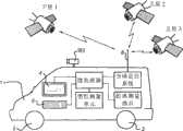
图1显示采用汽车1形式的MMS系统。汽车1具有一个或一个以上相机9(i),i=1,2,3,...I。汽车1可由驾驶员驾驶着沿感兴趣的道路行驶。Figure 1 shows an MMS system in the form of a car 1 . The car 1 has one or more cameras 9(i), i=1, 2, 3, . . . Car 1 can be driven by a driver along a road of interest.
汽车1具有多个车轮2。此外,汽车1具有高精确度位置确定装置。如图1中所示,所述位置确定装置包括以下组件:Motor vehicle 1 has a plurality of
·GPS(全球定位系统)单元,其连接到天线8且经布置以与多个卫星SLi(i=1,2,3,...)通信且依据从卫星SLi接收的信号计算位置信号。所述GPS单元连接到微处理器μP。基于从所述GPS单元接收的信号,所述微处理器μP可确定将显示于汽车1中的监视器4上的适宜的显示信号,从而告知驾驶员汽车的所在位置及所述汽车可能正沿哪一方向行进。替代GPS单元,可使用差分GPS单元。差分全球定位系统(DGPS)是对全球定位系统(GPS)的增强,其使用固定的基于地面的参考站网络来广播由卫星系统所指示的位置与已知固定位置之间的差。这些站广播所测量的卫星伪距与实际(在内部计算的)伪距之间的差,且接收站可将其伪距校正相同量。• A GPS (Global Positioning System) unit connected to the antenna 8 and arranged to communicate with a number of satellites SLi (i=1, 2, 3, . . . ) and to calculate position signals from the signals received from the satellites SLi. The GPS unit is connected to a microprocessor μP. Based on the signal received from the GPS unit, the microprocessor μP can determine an appropriate display signal to be displayed on the monitor 4 in the car 1, thereby informing the driver where the car is and that the car may be on the way. Which direction to go. Instead of a GPS unit, a differential GPS unit may be used. The Differential Global Positioning System (DGPS) is an enhancement to the Global Positioning System (GPS) that uses a fixed network of ground-based reference stations to broadcast the difference between a position indicated by a satellite system and a known fixed position. These stations broadcast the difference between the measured satellite pseudoranges and the actual (internally calculated) pseudoranges, and receiving stations can correct their pseudoranges by the same amount.
·DMI(距离测量器具)。此器具是通过感测车轮2中的一者或一者以上的旋转次数来测量汽车1行进的距离的计程仪。所述DMI还连接到微处理器μP以允许所述微处理器μP考虑由所述DMI测量的距离,同时依据来自所述GPS单元的输出信号计算显示信号。• DMI (Distance Measuring Instrument). This instrument is an odometer that measures the distance traveled by the car 1 by sensing the number of rotations of one or more of the
·IMU(惯性测量单元)。此IMU可实施为3个回转仪单元,其经布置以测量沿3个正交方向的旋转加速度及平移加速度。所述IMU还连接到微处理器μP以允许所述微处理器μP考虑所述DMI的测量结果,同时依据来自所述GPS单元的输出信号计算显示信号。所述IMU还可包括航位推算传感器。• IMU (Inertial Measurement Unit). Such an IMU may be implemented as 3 gyro units arranged to measure rotational and translational accelerations in 3 orthogonal directions. The IMU is also connected to a microprocessor μP to allow the microprocessor μP to take into account the measurements of the DMI while calculating display signals from the output signal from the GPS unit. The IMU may also include dead reckoning sensors.
如图1中所示的系统为所谓的“移动测绘系统”,其例如通过借助安装于汽车1上的一个或一个以上相机9(i)拍摄图片来收集地理数据。所述相机连接到微处理器μP。所述汽车前方的相机9(i)可为立体相机。所述相机可经布置以产生图像序列,其中已以预界定帧速率俘获了图像。在实例性实施例中,所述相机中的一者或一者以上为静止图片相机,其经布置以在汽车1的每一预界定位移或每一时间间隔俘获图片。所述预界定位移经挑选以使得两个后续图片包括路面的相似部分,亦即,具有相同地理位置或表示相同地理区域。例如,可在每8米的行进后俘获一图片。The system shown in FIG. 1 is a so-called "mobile mapping system" which collects geographic data, for example by taking pictures by means of one or more cameras 9(i) mounted on the car 1 . The camera is connected to a microprocessor μP. The camera 9(i) in front of the car can be a stereo camera. The camera may be arranged to generate a sequence of images in which images have been captured at a predefined frame rate. In an example embodiment, one or more of said cameras is a still picture camera arranged to capture a picture at every predefined displacement of the car 1 or at every time interval. The predefined displacements are chosen such that two subsequent pictures comprise similar parts of the road surface, ie have the same geographical location or represent the same geographical area. For example, a picture may be captured after every 8 meters of travel.
通常想要从3个测量单元GPS、IMU及DMI尽可能精确地提供位置和定向测量。测量这些位置和定向数据,同时相机9(i)拍摄图片。存储这些图片以供稍后联合在拍摄这些图片的同时收集的汽车1的对应的位置和定向数据用于μP的适宜的存储器中。这些图片包含关于道路信息的信息,例如,道路的中心、路面边缘及道路宽度。It is generally desirable to provide position and orientation measurements as accurately as possible from the 3 measurement units GPS, IMU and DMI. These position and orientation data are measured while the camera 9(i) takes pictures. These pictures are stored for later use in a suitable memory of the μP in conjunction with the corresponding position and orientation data of the car 1 collected while taking these pictures. These images contain information about road information, such as the center of the road, the edge of the road, and the width of the road.
图2显示哪些位置信号可从图1中所示的三个测量单元GPS、DMI及IMU获得。图2显示微处理器μP经布置以计算6个不同参数,亦即,相对于预定坐标系统中的原点的3个距离参数x、y、z;以及3个角参数ωx、ωy及ωz,其分别表示分别围绕x轴、y轴及z轴的旋转。z方向与重力矢量的方向一致。Figure 2 shows which position signals are available from the three measurement units GPS, DMI and IMU shown in Figure 1 . Figure 2 shows that the microprocessor μP is arranged to calculate 6 different parameters, namely, 3 distance parameters x, y, z with respect to the origin in a predetermined coordinate system; and 3 angular parameters ωx , ωy and ωz , which represent rotations around the x-axis, y-axis, and z-axis, respectively. The z direction coincides with the direction of the gravity vector.
汽车1中的微处理器及存储器9可实施为计算机布置。图14中显示此计算机布置的实例。The microprocessor and
图3显示根据本发明产生道路信息的过程的实例性实施方案的框图。所述过程通过借助如图1中所示的移动测绘车辆俘获具有相关联的位置和定向数据的源图像序列且将所俘获的数据存储在存储媒体上而以MMS(移动测绘系统)对话31开始。在过程块32中,处理所俘获的数据以针对具有相关联的位置和定向数据的每一源图像产生经正射校正的图像块。所述相关联的位置和定向数据包含可从GPS、DMI及IMU获得的位置信号以及相应相机相对于汽车的位置和定向的位置和定向。下文将更详细地描述经正射校正的图像块从源图像的产生。所述位置和定向数据使得我们能够叠加两个连续图像,包括路面中表示具有相同地理位置的相同地理区域的相似部分。此外,从所俘获的数据中的位置和定向数据,可确定汽车的轨迹线。Fig. 3 shows a block diagram of an exemplary embodiment of a process of generating road information according to the present invention. The process begins with an MMS (Mobile Mapping System) dialog 31 by capturing a sequence of source images with associated position and orientation data by means of a mobile mapping vehicle as shown in FIG. 1 and storing the captured data on a storage medium . In process block 32, the captured data is processed to produce orthorectified image blocks for each source image with associated position and orientation data. The associated position and orientation data includes position signals available from GPS, DMI, and IMU, and the position and orientation of the corresponding cameras relative to the position and orientation of the car. The generation of orthorectified image blocks from source images will be described in more detail below. The position and orientation data allow us to superimpose two consecutive images comprising similar parts of the road surface representing the same geographic area with the same geographic location. Additionally, from the position and orientation data in the captured data, the trajectory of the car can be determined.
使用这些经正射校正的图像块来检测对应于路面上的移动对象的像素且导出道路色彩样本。块33表示检测移动对象的像素的过程,且块34表示用于导出道路色彩样本的过程。对相同图像同时执行两个过程。因此,块33针对第n个图像产生经正射校正的二进制第n个图像,其中针对每一像素指示所述像素是对应于固定对象还是移动对象,且块34针对第n个图像产生相关联的道路色彩样本。道路色彩样本为具有已辨识为一个或一个以上连续源图像中的路面的色彩的值的色彩值的集合,例如,基于相机相对于移动测绘车辆的行驶方向的定向的第n个图像的像素值应表示在正常条件下的路面。例如,从来自所述图像中的多边形的像素提取道路色彩样本,其中所述多边形的区域对应于车辆将行驶于其上的路面。These orthorectified image patches are used to detect pixels corresponding to moving objects on the road surface and derive road color samples. Block 33 represents the process of detecting pixels of moving objects, and block 34 represents the process for deriving road color samples. Perform both processes simultaneously on the same image. Thus, block 33 produces an orthorectified binary nth image for the nth image, where for each pixel it is indicated whether the pixel corresponds to a stationary object or a moving object, and block 34 produces for the nth image the associated road color swatches. A road color sample is a collection of color values with values that have been identified as the color of the road surface in one or more consecutive source images, e.g., the pixel value of the nth image based on the orientation of the camera relative to the direction of travel of the mobile mapping vehicle Shall represent the road surface under normal conditions. For example, a road color sample is extracted from pixels from a polygon in the image, where the area of the polygon corresponds to the road surface on which the vehicle will travel.
在块35中,使用第n个源图像的道路色彩样本来选择所述第n个源图像中具有包含于所述道路色彩样本中的色彩的所有像素。随后,将把所述第n个图像中已识别为对应于移动对象的像素标记为非固定像素。块35的结果为针对每一像素指示所述第n个图像中相关联的像素是否对应于路面且是否对应于移动对象的二进制经正射校正的图像。In block 35, the road color samples of the nth source image are used to select all pixels in said nth source image that have a color contained in said road color samples. Subsequently, pixels in the nth image that have been identified as corresponding to moving objects will be marked as non-stationary pixels. The result of block 35 is a binary orthorectified image that indicates, for each pixel, whether the associated pixel in the nth image corresponds to a road surface and corresponds to a moving object.
在块36中,从所述二进制经正射校正的图像确定左侧及右侧或道路位置。下文将更详细地描述用以确定道路的左侧及右侧的算法。使用所确定的位置来导出所述第n个图像中所示的路面的中心的位置及所述路面的宽度。借助与所述第n个源图像相关联的位置和定向数据,可计算道路的中心的对应的地理位置。In block 36, left and right or road positions are determined from the binary orthorectified image. The algorithm used to determine the left and right sides of the road will be described in more detail below. The determined position is used to derive the position of the center of the road surface shown in the nth image and the width of the road surface. With the position and orientation data associated with said nth source image, a corresponding geographic location of the center of the road can be calculated.
此外,在块36中,使用所述二进制经正射校正的图像来检测、识别并抽取描述车道标记及其它所涂绘道路标记的道路信息。如果从仅表示路面的背景色彩的像素获得道路色彩样本,那么将不把对应于道路涂料的像素指派为路面像素。所述道路涂料将被看作二进制图像中的孔。可通过分析这些孔及其对应的位置和定向来识别道路信息,例如,车道分隔带、中断线、实心车道线、虚线及其它规格化的道路标记。确定孔的形状及大小且使其与车道标记及其它规格化的道路涂料的已知特性匹配。在实施例中,针对每一孔产生多边形。使用所述多边形来识别对应的道路涂料。通过识别图像中道路的车道分隔带,可导出车道的总数目。可相对于路边、道路的中心线及邻近道路标记的位置验证所匹配孔的位置和定向以减小错误检测的道路信息项目的数目。此外,可使用孔内像素的色彩值来分析所述孔以进一步减小有误差的检测。Furthermore, in block 36, the binary orthorectified image is used to detect, identify and extract road information describing lane markings and other painted road markings. If the road color samples were obtained from pixels representing only the background color of the road, then the pixels corresponding to road paint would not be assigned as road pixels. The road paint will be seen as holes in the binary image. Analysis of these holes and their corresponding locations and orientations can be used to identify road information such as lane dividers, break lines, solid lane lines, dashed lines, and other normalized road markings. Holes are shaped and sized to match known characteristics of lane markings and other standardized road paint. In an embodiment, a polygon is generated for each hole. The polygons are used to identify corresponding road paint. By identifying the lane dividers of the roads in the image, the total number of lanes can be derived. The location and orientation of the matched holes may be verified relative to the location of the roadside, the centerline of the road, and adjacent road markings to reduce the number of falsely detected road information items. Furthermore, the color values of the pixels within the wells can be used to analyze the wells to further reduce erroneous detections.
在块37中,将道路的所计算的中心及道路宽度以及其它道路信息项目存储为供在数字地图数据库中使用的数据库中的属性。此数字地图数据库可在导航应用(例如,导航系统及类似系统)中使用,以在显示器上显示表示用户正在上面行驶的道路的透视图或俯视图或使用与方向指引或安全应用有关的信息。现将更详细地揭示图3中所示的相应块。In block 37 the calculated center and road width of the road and other road information items are stored as attributes in the database for use in the digital map database. This digital map database can be used in navigation applications (eg, navigation systems and similar systems) to display on a display a perspective or overhead view representing the road the user is driving on or to use information related to direction-guidance or safety applications. The corresponding blocks shown in Figure 3 will now be disclosed in more detail.
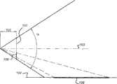
图4显示在块32中执行的将源图像转换成经正射校正的图像块的一般原理的侧视图。相机或CCD相机202(图2中所示)中的图像传感器101记录源图像序列。所述源图像表示由如图1中所示安装于汽车上的基于陆地的相机9(i)记录的更多或更少垂直图像。所述源图像可为借助静止图片相机记录的静止图片序列,所述相机在例如8米的每一位移被触发。包括所述图像传感器的相机具有视角α。所述视角α由所述相机的透镜的焦距102确定。所述视角α可在45°<α<180°的范围中。此外,所述相机具有视轴(looking axis)103,其处于视角的中心。在图1中,视轴103平行于水平平面104。图像传感器101垂直于视轴103安装。在此情况中,图像传感器101记录“纯”垂直源图像。如果进一步已知所述图像传感器相对于水平平面(例如,地球表面)的高度,那么由图像传感器101记录的图像可变换为表示水平平面的俯视图的经缩放版本的经正射校正的图像块。为在水平方向上获得具有适宜分辨率的水平线图像,使用所述图像传感器的有限区域。图4显示图像传感器101的对应于水平平面中的部分108的部分106。所述经正射校正的图像块的最小可接受分辨率确定所述图像传感器与水平平面中的最远点之间的最大距离。借助三角法,从所述基于陆地的相机检索的源图像可转换为任一虚平面。即使所述视轴相对于水平平面以一已知角度成角度,也可从源图像获得经正射校正的图像块。FIG. 4 shows a side view of the general principle of the conversion of the source image into orthorectified image blocks performed in block 32 . An
图5显示将源图像转换成经正射校正的图像块200的一般原理的俯视图。相机202的视轴103、218的视角及定向确定水平平面的由图像传感器101记录的部分。经正射校正的图像块200的边沿由参考编号224指示。在图5中,相机202的视轴218与道路的具有车道标记的方向中心轴一致。属性集合及导航系统及类似系统所需的精确度需要所述经正射校正的图像块的预界定最小分辨率。这些要求限制水平平面的可从源图像获得的部分。相机焦点208相对于水平平面的位置与水平平面的区域的边界之间的最大距离206确定所述最小分辨率。此外,实际上,最大距离206可受到两个汽车当行驶于特定道路上时其之间的最小距离的限制。因此,通过限制最大距离,在大多数情况中具有如下优点:经正射校正的图像块中的路面不包括行驶于移动测绘车辆前方的汽车的后面。此外,最大距离206与最小距离204之间的差确定相机的后续图像记录之间的最大可允许距离。此可限制车辆的最大行驶速度。水平平面的矩形对应于源图像中近似具有梯形形式的区域。从图5可见,所述最小距离及所述视角确定经正射校正的图像块200是否包括在源图像中不具有对应的区域的小区域210。经正射校正的图像块200为虚线正方形且小区域210为在接近由200所指示的虚线正方形的角落处切出的小三角形。FIG. 5 shows a top view of the general principle of converting a source image into an orthorectified image patch 200 . The viewing angle and orientation of the viewing axes 103 , 218 of the camera 202 determine the portion of the horizontal plane that is recorded by the
在实施例中,经正射校正的图像块200对应于具有16m宽度220及16m长度222的区域。在每8米俘获图像的情况中,可在两个连续图像中看见99%的路面。对于所述经正射校正的图像块的进一步处理,具有呈矩形形式的经正射校正的图像块是有利的。将给予所述经正射校正的图像块的在源图像中不具有相关联的像素的像素预界定色彩值。预界定色彩值的实例为对应于现有路面色彩的色彩或在源图像中通常将不存在或几乎不存在的值。此减少所述经正射校正的图像块的进一步处理中误差的可能性。In an embodiment, the orthorectified image patch 200 corresponds to an area having a width 220 of 16 m and a length 222 of 16 m. With images captured every 8 meters, 99% of the road surface can be seen in two consecutive images. For further processing of said orthorectified image blocks it is advantageous to have orthorectified image blocks in rectangular form. Pixels of the orthorectified image block that do not have an associated pixel in the source image will be given a predefined color value. Examples of predefined color values are colors that correspond to existing road surface colors or values that would normally not exist or hardly exist in the source image. This reduces the likelihood of errors in the further processing of the orthorectified image block.
在转换源图像以针对每一像素216(离视轴具有距离214且离焦点208具有距离204)获得经正射校正的图像块的实施例中,借助三角法确定源图像中的对应的位置,在未公开的专利申请案PCT/NL2006/050252中更详细地描述三角法,所述专利申请案以参考方式同此并入。应注意,当将源图像转换为经正射校正的图像时,分辨率(每一像素表示的物理大小)改变(变得较大)。通过对源图像中相关联的像素的色彩值求平均值以获得所述经正射校正的图像的像素的色彩值来完成大小增加。所述求平均值具有使路面色彩样本成群且减少所述过程内的噪声的效应。In an embodiment where the source image is transformed to obtain an orthorectified image block for each pixel 216 (with a distance 214 from the boresight and a distance 204 from the focal point 208), the corresponding position in the source image is determined by means of trigonometry, Trigonometry is described in more detail in unpublished patent application PCT/NL2006/050252, which is hereby incorporated by reference. It should be noted that the resolution (the physical size represented by each pixel) changes (becomes larger) when converting the source image to an orthorectified image. The size increase is accomplished by averaging the color values of associated pixels in the source image to obtain the color values of the pixels of the orthorectified image. The averaging has the effect of clustering the pavement color samples and reducing noise within the process.
在一个实施例中,图6在上侧显示立体图像对。在下侧显示两个对应的所转换的经正射校正的图像块。可通过首先借助三角法或三角测量确定源图像中的对应的位置且其次复制源图像中最近像素的值来导出所述经正射校正的图像块中像素的值。还可通过在四个或9个最近像素之间插值获得所述值。虚线302及304指示源图像的用于获得经正射校正的图像块的区域。在优选实施例中,所述经正射校正的图像块为矩形。使用立体相机将导致产生具有相对大重叠区域的两个经正射校正的图像块序列。图7显示通过叠加图6中的两个经正射校正的图像块获得的经正射校正的镶嵌图。所述叠加可基于相应经正射校正的图像块的地理位置。从位置确定函数导出每一经正射校正的图像块的地理位置,所述位置确定函数包含来自移动车辆的GPS位置、移动车辆的行驶方向或定向、移动车辆上相机的位置及移动车辆上相机的定向。将为导出经正射校正的图像块的地理位置的这些参数存储为与源图像相关联的位置和定向数据。分别从图6中的左经正射校正的图像块及右经正射校正的图像块获得经正射校正的镶嵌图的左区域402及右区域406。从左经正射校正的图像块或右经正射校正的图像块的对应的区域获得经正射校正的镶嵌图的中间区域404。在前方使用一立体相机或两个相机的优点是,可获得较大/较宽广的经正射校正的镶嵌图,因为两个相机可在比仅一个所述相机更大的角度上记录图像。相似地,结合侧面查看相机使用前方查看相机使得我们能够从极宽广的道路或具有人行道的街道获得精确的经正射校正的镶嵌图。以此方式,可产生以其全宽度表示路面的经正射校正的图像。In one embodiment, Figure 6 shows a stereoscopic image pair on the upper side. Two corresponding converted orthorectified image patches are shown on the lower side. The value of a pixel in the orthorectified image block may be derived by first determining the corresponding position in the source image by means of triangulation or triangulation and second copying the value of the nearest pixel in the source image. The value can also be obtained by interpolating between the four or 9 nearest pixels. Dashed
在块34中,从经正射校正的图像获得道路色彩样本以检测所述经正射校正的图像中的路面。图8显示用于获得道路色彩样本的区域的实例。汽车行驶于道路800上。箭头804识别汽车的行驶方向。以806指示的区域为路边。当汽车行驶于道路上时,我们可假设在汽车正前面必须仅为道路。然而,路面的像素不具有一种色彩而具有来自所谓的色空间的色彩。在每一经正射校正的图像中,界定通常包括表示路面的像素的预界定区域802。预界定区域802可呈矩形形式,其表示移动测绘车辆前方的车道中距5-11米的区域中的像素。优选地,所述预界定区域包含所述车辆的轨迹线且足够窄以便从车道标记排除含有色彩的像素且仅包含表示路面的背景色彩的像素。使用来自预界定区域802中的像素的色彩来产生道路色彩样本。使用所述道路色彩样本来确定像素是否可能是路面。如果像素具有所述经正射校正的图像的所述道路色彩样本中存在的色彩值,那么所述像素可能是路面。可最接从记录移动测绘车辆前方的道路的图像(例如,来自立体相机的图像对的图像中的一者)获得所述道路色彩样本,因为这些图像包含所述车辆的轨迹线且所述轨迹线通常在路面上。可从一个图像提取道路色彩样本以检测所述图像中的路面。工程师可找到许多方式来获得色彩样本且可对许多参数求平均值。在另一实施例中,可从多于一个连续图像提取道路色彩样本。还可每n个图像地确定道路色彩样本且可将所述道路色彩样本用于第n个图像及(n-1)个连续图像。有规则地获得道路色彩样本很重要,因为路面的色彩在很大程度上取决于道路的照明条件及灯强度。在阴影中的路面经具有与在直接阳光中的路面明显不同的道路色彩样本。因此,如果足够处理能力可用于每一经正射校正的图像,那么应确定对应的道路色彩样本且将所述道路色彩样本用于检测所述图像中的路面。此外,可组合来自数个图像的道路色彩样本以实现对不想要的暂时样本的过滤。In block 34, road color samples are obtained from the orthorectified image to detect road surfaces in the orthorectified image. Figure 8 shows an example of an area used to obtain road color samples. The car is driving on the road 800 . Arrow 804 identifies the direction of travel of the car. The area indicated at 806 is the curb. When a car is on the road, we can assume that there must be only the road directly in front of the car. However, the pixels of the road surface do not have one color but a color from a so-called color space. In each orthorectified image, a predefined area 802 is defined that typically includes pixels representing a road surface. The predefined area 802 may be in the form of a rectangle representing pixels in an area 5-11 meters apart in the lane in front of the mobile mapping vehicle. Preferably, the predefined area contains the trajectory line of the vehicle and is narrow enough to exclude pixels containing color from lane markings and to contain only pixels representing a background color of the road surface. Colors from pixels in the predefined area 802 are used to generate road color samples. The road color samples are used to determine whether a pixel is likely to be road. A pixel may be a road surface if the pixel has a color value present in the road color sample of the orthorectified image. The road color samples may be obtained most directly from images recording the road ahead of the mobile mapping vehicle (e.g., one of images from a pair of images from a stereo camera), since these images contain the trajectory lines of the vehicle and the trajectory Lines are usually on the road. Road color samples may be extracted from an image to detect road surfaces in the image. Engineers can find many ways to obtain color samples and average many parameters. In another embodiment, road color samples may be extracted from more than one consecutive image. A road color sample may also be determined every n images and may be used for the nth image and (n-1) consecutive images. It is important to obtain road color samples regularly, because the color of the road surface depends largely on the lighting conditions of the road and the intensity of the lights. A pavement in shade would have a significantly different road color sample than a pavement in direct sunlight. Therefore, if sufficient processing power is available for each orthorectified image, a corresponding road color sample should be determined and used to detect the road surface in the image. Furthermore, road color samples from several images can be combined to enable filtering of unwanted temporal samples.
所述道路色彩样本可受到移动车辆前方的移动对象的色彩的污染。因此,视情况,可从所述道路色彩样本排除块33中检测为移动对象像素的像素的色彩值。以此方式,可避免对所述道路色彩样本的污染。此选项在图3中由到块34的虚线指示。The road color samples may be contaminated by the color of moving objects in front of the moving vehicle. Therefore, the color value of a pixel detected as a moving object pixel may be selected from the road color sample exclusion block 33 as appropriate. In this way, contamination of the road color samples can be avoided. This option is indicated by the dashed line to block 34 in FIG. 3 .
应注意,图8表示源图像的经正射校正的部分。当视轴不平行于车辆的行驶方向时,所述部分的轮廓不对称(如图所示)。It should be noted that Figure 8 represents an orthorectified portion of the source image. When the viewing axis is not parallel to the direction of travel of the vehicle, the profile of the portion is not symmetrical (as shown).
为能够确定道路的宽度及中心,相机必须俘获道路的全宽度。通常,当汽车正行驶于所述道路上时,其与所述汽车前方的车辆之间存在最小距离。此距离可用于确定预界定区域以获得道路色彩样本。此外,可假设一直到所述汽车前方出现汽车,在图像中可看不到除路面以外的任何其它情况。然而,在所述道路的其它车道中,移动对象(例如,汽车、摩托车、有篷货车)可通过移动测绘车辆。对应于这些移动车辆的像素不应分类为路面。To be able to determine the width and center of the road, the camera must capture the full width of the road. Typically, when a car is driving on the road, there is a minimum distance between it and the vehicle in front of the car. This distance can be used to determine a predefined area to obtain road color samples. Furthermore, it can be assumed that until a car appears in front of the car, nothing other than the road surface can be seen in the image. However, in other lanes of the road, moving objects (eg, cars, motorcycles, vans) may pass the mobile mapping vehicle. Pixels corresponding to these moving vehicles should not be classified as road.
图3中的块33检测源图像中移动对象的像素。可在两个连续经正射校正的图像中的共用区域中检测移动对象的像素。图9显示叠加两个后续图像的结果。参考编号902及904指示第n个及第(n+1)个经正射校正的图像的具有已从第n个及第(n+1)个源图像导出的像素的部分的边界。箭头908指示移动测绘车辆的行驶方向。假设所述第n个及第(n+1)个经正射校正的图像在行驶方向上包括16米的道路且所述第(n+1)个图像是在移动测绘车辆在俘获第n个图像后在8米的位移后拍摄。在那一情况中,在车辆的行驶方向上存在为8米的共用平面906。与对应于第(n+1)个图像的共用平面的像素相比,对应于第n个图像的共用平面906的像素对应于另一时刻。移动对象在第n个及第(n+1)个图像中将具有不同位置,而固定对象将不在共用平面906中移动。可通过确定在共用平面906中具有等效位置的像素之间的色彩距离来找到移动对象的像素。Block 33 in Figure 3 detects pixels of moving objects in the source image. Pixels of moving objects can be detected in a common area in two consecutive orthorectified images. Figure 9 shows the result of superimposing two subsequent images.
共用平面906中第n个图像的像素由rn、gn、bn表示,其中r、g及b对应于像素的红色、绿色及蓝色色彩值。共用平面906中处于相同位置处的第(n+1)个图像的像素由rn+1、gn+1、bn+1表示。在范例实施例中,在共用平面中具有相同位置的所述像素的色彩由以下方程式确定:A pixel of the nth image in
其中:in:
distR=(rN-rN+1)2distR=(rN -rN+1 )2
distG=(gN-gN+1)2distG=(gN -gN+1 )2
distB=(bN-bN+1)2distB=(bN -bN+1 )2
如果dist>thr2,其中thr为自适应阈值,那么所述像素表示移动对象,否则所述像素表示固定的某事物。在实施例中,所述阈值在经典RGB空间中为102-152的距离。另一方法是使用相对于光谱特性(例如,像素的平均色彩)的距离。工程师可找到许多其它方式来确定像素是表示移动对象还是表示固定的某事物。If dist > thr2 , where thr is the adaptive threshold, then the pixel represents a moving object, otherwise the pixel represents something stationary. In an embodiment, the threshold is a distance of 102 -152 in classical RGB space. Another approach is to use distance relative to a spectral characteristic (eg, the average color of a pixel). Engineers can find many other ways to determine whether a pixel represents a moving object or something stationary.
应注意,替代RGB空间,在本发明中可使用其它色空间。色空间的实例为绝对色空间、LUV色空间、CIELAB、CIEXYZ、Adobe RGB及sRGB。这些相应色空间中的每一者具有其特定优点及缺点。It should be noted that instead of the RGB space, other color spaces may be used in the present invention. Examples of color spaces are absolute color space, LUV color space, CIELAB, CIEXYZ, Adobe RGB, and sRGB. Each of these respective color spaces has its particular advantages and disadvantages.
图10显示在执行对对应于第n个及第(n+1)个经正射校正的图像1002、1004的共用平面1006的像素上的移动对象的像素的检测后的实例性结果。所述结果为二进制图像,其中白色像素与固定对象相关联,且黑色像素与移动对象相关联。移动对象为在第n个及第(n+1)个源图像中具有不同地理位置的对象。在第n个及第(n+1)个经正射校正的图像1002、1004的共用平面1006中检测所述移动,且如果所述共用平面中的像素具有大于两个连续图像之间的阈值量的色移,那么所述像素与移动对象相关联。图10中的移动对象1010可为行驶于另一车道上的车辆。箭头1008指示携载相机的车辆的行驶方向。FIG. 10 shows exemplary results after performing detection of pixels of moving objects on pixels corresponding to the
使用与由块34产生的第n个图像相关联的道路色彩样本来检测表示所述第n个图像中的路面的像素且产生路面图像。针对所述第n个图像的共用平面906中的每一像素,进行检查以看所述像素的色彩值是否处于道路色彩样本中或在距所述道路色彩样本中的任一色彩或来自所述道路色彩样本的一个或一个以上特性(例如,道路色彩样本的平均色彩或色谱)的预定距离内。如果是这样,那么路面图像中的对应的像素将被分类为路面像素。应注意,通过处理源图像中多于一个像素的值获得经正射校正的图像中的像素。此减少道路色彩样本的色彩光谱中的噪声,且因此改善路面像素选择及识别的质量。此外,应注意,可使用文理分析及段生长或区生长算法来从经正射校正的图像选择路面像素。使用与由块33产生的指示像素是固定像素还是对应于移动对象的第n个图像相关联的二进制图像来给路面图像中的每一图像指派对应的参数。使用路面图像的这两个性质来选择道路边缘像素且产生道路边缘图像。首先,针对所述路面图像中的每一行,选择、识别最左及最右像素且将其存储为道路边缘像素的一部分以供进一步处理。应注意,可使用其它算法来选择道路边缘像素,例如,选择路面中形成最左及最右毗邻像素链的像素。其次,针对每一道路边缘像素,验证其位置是否靠近对应于移动对象的像素。如果道路边缘像素靠近移动对象像素,那么可将所述像素标记为可疑像素或可将其从二进制图像中的道路边缘像素排除。如果道路边缘像素与最近移动对象像素之间的距离小于三个像素,那么将所述道路边缘像素视为靠近于移动对象像素。在实施例中,当路面中的对应的被标记为移动对象像素时,将道路边缘像素标记为可疑像素或将其排除。可使用所述可疑指示来确定其是否仍可能以预定可靠性来自动地导出对应于源图像的道路边缘的位置。如果存在太多可疑道路边缘像素,那么所述方法可经布置以提供源图像从而使得人类能够在所述源图像或经正射校正的源图像中指示左道路边缘及/或右道路边缘的位置。因此获得的位置存储在数据库中以供进一步处理。因此,如果由块33产生的二进制图像指示共用平面中的像素为固定像素且经正射校正的图像中相关联的像素的色彩为来自道路色彩样本的色彩,那么将所述像素分类为道路边缘像素。将任一不满足此要求的像素分类为道路边缘像素。当显形路面图像且从路面像素排除对应于移动对象的像素时,将把移动对象看作路面中的孔或路面的侧处的切口。The road color samples associated with the nth image produced by block 34 are used to detect pixels representing the roadway in the nth image and produce a roadway image. For each pixel in the
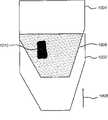
图11显示路面图像1100的理想化实例,其包括路面1102、左道路边缘及右道路边缘1104、1106以及沿道路1108的草地边沿。此外,图11显示路面图像1100、车辆1110的行驶方向以及道路的所计算的左侧及右侧1112、1114上的上覆图。路面1102的边缘1104、1106不平滑,因为靠近路边的路面的色彩可不同于道路色彩样本。例如,路边可覆盖有灰尘。此外,道路色彩可因阴影而出现偏离。因此,这些边缘为锯齿状。在块36中,首先将确定路面图像中的边缘像素。边缘像素为垂直于行驶方向的线1116上的极端路面像素。以此方式,路面内部中的孔因移动对象或其它噪声而将不导致对道路边缘的虚假检测。应注意,在图11中,道路边缘1104及1106由连续线表示。实际上,因(例如)移动对象,道路边缘可不连续,因为可排除标记为可疑像素的道路边缘像素。FIG. 11 shows an idealized example of a
其次,将边缘点拟合为直线。下文所述的算法是基于道路的边缘大致平行于车辆的行驶方向的假设。使用平行于行驶方向的条纹或窗来获得对路面图像中的路面的左侧及右侧的位置的粗略估计。所述条纹具有预界定宽度。将所述条纹从左侧移动到右侧且针对所述条纹的每一可能位置确定落在所述条纹内的道路边缘像素的数目。可以条形图表示每一位置的道路边缘像素的数目。图12显示可在上述方法像图11一样应用于路面图像以确定路边的位置时获得的条形图。垂直轴1202指示落在所述条纹内的道路边缘像素的数目,且水平轴1204指示所述条纹的位置。将形成顶部或在局部具有最大数目的像素的位置视为粗略地指示路边的位置。所述位置为粗略位置,因为路边的确切位置在所述条纹内。可通过将落在所述条纹中的边缘像素拟合为平行于行驶方向的直线来确定路边的位置。例如,可使用众所周知的线性最小二乘法拟合技术来找到平行于行驶方向通过边缘像素的最佳拟合直线。还已发现多边形骨架算法及稳健线性回归算法(例如,基于中值的线性回归)极适于确定道路边缘的位置、道路宽度及中心线。因为已知经正射校正的图像的地理位置,所以可极容易地计算因此找到的直线的地理位置。以相似方式,可确定右路边的位置。应注意,可将边缘像素应用于任一线拟合算法从而替代直的道路边缘获得曲线状路边。此将增加处理源图像所需的处理能力,但可有益于道路的弯曲。将所确定的道路边缘及中心线存储为一组参数,所述参数包含端点及形状点的位置中的至少一者。所述组参数可包括用于表示的多项式的系数的参数,所述多项式表示对应的线。Second, fit the edge points to a straight line. The algorithm described below is based on the assumption that the edges of the road are approximately parallel to the direction of travel of the vehicle. Stripes or windows parallel to the direction of travel are used to obtain a rough estimate of the location of the left and right sides of the road in the road image. The stripes have a predefined width. The stripe is moved from left to right and the number of road edge pixels that fall within the stripe is determined for each possible location of the stripe. The number of road edge pixels at each location can be represented in a bar graph. FIG. 12 shows a bar graph that can be obtained when the above method is applied to a road surface image as in FIG. 11 to determine the position of the roadside.
用于确定上文所界定的路边的位置的算法可用于任一经正射校正的图像上,其中已知车辆相对于所述图像的定向的行驶方向。所述行驶方向及定向允许我们精确地确定所述图像内当车辆行驶于直的道路或甚至弯曲道路上时对应于所述车辆的轨迹线的区域。可使用此区域来获得道路色彩样本。因为所述轨迹线通常跨越路面,所以可自动地获得所述道路色彩样本,而不执行专门图像分析算法来确定图像的哪一区域可表示路面。The algorithm for determining the position of the roadside defined above can be used on any orthorectified image for which the direction of travel of the vehicle relative to the orientation of the image is known. The direction of travel and orientation allows us to precisely determine the area within the image that corresponds to the trajectory of the vehicle as it travels on a straight road or even a curved road. Use this area to obtain road color samples. Because the trajectory lines generally span the road surface, the road color samples can be obtained automatically without performing a special image analysis algorithm to determine which region of the image may represent the road surface.
在有利实施例中,块32经布置以产生经正射校正的图像,其中所述经正射校正的图像的像素的列与车辆的行驶方向相对应。在此情况中,可极容易地确定路边的位置。如上文中所揭示的条纹中边缘像素的数目对应于x个毗邻列中边缘像素的和,其中x为列数目且对应于所述条纹的宽度。优选地,所述条纹的位置对应于形成所述条纹的列的中间列的位置。在实施例中,所述条纹的宽度对应于为1.5米的宽度。In an advantageous embodiment, block 32 is arranged to generate an orthorectified image, wherein the columns of pixels of the orthorectified image correspond to the direction of travel of the vehicle. In this case, the position of the roadside can be determined extremely easily. The number of edge pixels in a stripe as disclosed above corresponds to the sum of edge pixels in x adjacent columns, where x is the number of columns and corresponds to the width of the stripe. Preferably, the position of said stripes corresponds to the position of a middle column of the columns forming said stripes. In an embodiment, the width of said stripes corresponds to a width of 1.5 meters.
用于确定路边的位置的算法可包括如下动作:An algorithm for determining the location of a roadside may include the following actions:
-针对每一列像素,对边缘像素的数目进行计数;- for each column of pixels, count the number of edge pixels;
-针对每一列位置,合计x个毗邻列的边缘像素的数目;- for each column position, sum the number of edge pixels of x adjacent columns;
-确定在这x个毗邻列的所合计边缘像素的数目中具有局部最大值的列的位置;- determining the position of the column having a local maximum in the number of summed edge pixels of the x adjacent columns;
-确定对应于与先前所确定的位置相关联的则x个毗邻列的边缘像素的平均值(列)位置。- Determining an average (column) position of edge pixels corresponding to then x adjacent columns associated with the previously determined position.
所有这些动作可以简单操作执行,例如计数、加法、比较及求平均数。经正射校正的图像的左部中的局部最大值与左路边相关联,且经正射校正的图像的右部中的局部最大值与右路边相关联。All these actions can be performed with simple operations such as counting, adding, comparing and averaging. The local maxima in the left portion of the orthorectified image are associated with the left curb, and the local maxima in the right portion of the orthorectified image are associated with the right curb.
在已确定了对应于左路边及右路边的直线的位置后,可通过计算左路边及右路边的平均位置来确定道路的中心。可将道路的中心存储为以(例如)端点的具有纬度及经度的坐标表征的一组参数。可通过计算左路边与右路边的位置之间的距离来确定道路的宽度。图13显示经正射校正的图像1302的实例。道路的右所检测边缘、道路的左所检测边缘及道路的所计算的中心线叠加于所述图像上。After the positions of the lines corresponding to the left and right curbs have been determined, the center of the road can be determined by calculating the average position of the left and right curbs. The center of the road may be stored as a set of parameters characterized by, for example, the coordinates of the endpoints with latitude and longitude. The width of the road can be determined by calculating the distance between the positions of the left and right curbs. FIG. 13 shows an example of an
应注意,上述方法使用色彩信息及对与移动对象相关联的像素的检测两者。应注意,所述方法还在无对所述像素的检测的情况中很好地执行。在那一情况中,每次仅使用一个源图像来产生供在地图数据库中使用的道路信息。It should be noted that the methods described above use both color information and the detection of pixels associated with moving objects. It should be noted that the method also performs well without detection of the pixel. In that case, only one source image at a time is used to generate road information for use in the map database.
图15a、15b及15c显示从由如图1中所示的MMS系统获得的图像序列提取的三个源图像的实例。已通过以规则间隔拍摄图像获得了所述图像序列。以此方式,产生具有预界定帧速率(例如,30帧/秒或25帧/秒)的图像序列。图15a到15c中所示的三个源图像不是所述图像序列的后续图像。借助高精确度定位装置,针对每一图像,可精确地确定相机位置和定向。借助未公开的专利申请案PCT/NL2006/050252中所述的方法,透视图图像转换为经正射校正的图像,其中针对每一像素,可从位置和定向数据导出对应的地理位置。与每一经正射校正的图像相关联的位置和定向数据使得能够从所述经正射校正的图像产生经正射校正的镶嵌图。Figures 15a, 15b and 15c show examples of three source images extracted from a sequence of images obtained by the MMS system as shown in Figure 1 . The sequence of images has been obtained by taking images at regular intervals. In this way, a sequence of images with a predefined frame rate (eg, 30 frames/second or 25 frames/second) is generated. The three source images shown in Figures 15a to 15c are not subsequent images of the sequence of images. With the help of high-precision positioning devices, the camera position and orientation can be precisely determined for each image. By means of the method described in unpublished patent application PCT/NL2006/050252, the perspective image is converted into an orthorectified image, where for each pixel a corresponding geographic location can be derived from the position and orientation data. The position and orientation data associated with each orthorectified image enables an orthorectified mosaic to be generated from the orthorectified image.
图16显示从对应于图15a到15c中所示的三个源图像的图像序列以及插入图像获得的路面的经正射校正的镶嵌图。在所述经正射校正的镶嵌图中,指示对应于这三个图像的区域。由151a、152a及153a所指示的区域分别对应于图15a、15b及15c中所示的源图像的经正射校正的部分。由151b、152b及153b指示的区域分别对应于可已通过图15a、15b及15c中所示的源图像的对应的部分的正射校正获得的区域,但其不用于经正射校正的镶嵌图中,因为继图15a-15c中所示的源图像之后的图像提供相同区域但具有较高分辨率及所述汽车前方的汽车正遮挡对路面的观察的较少机会,因为位置相机与路面之间的距离较短。再次出于相同原因,也不使用最远部分151b、152b及153b但替代使用后续图像(未指示于图16中)。可见,仅源图像的小区域用于经正射校正的镶嵌图中。所使用的区域对应于从距MMS系统的预界定距离一直到与MMS系统在对应于帧速率的随后时间间隔期间的行进速度相关的距离的路面。源图像的所使用的区域将随着行进速度的增加而增加。在图16中进一步指示所述MMS系统的轨迹线160。相机位置与由源图像的像素表示的路面之间的最大距离优选小于正行驶于道路上的两个汽车之间的最小距离。如果情况如此,那么可产生道路区段的路面的经正射校正的镶嵌图,其因正行驶于所述MMS系统前方的车辆而不显示失真。Figure 16 shows an orthorectified mosaic of a road surface obtained from an image sequence corresponding to the three source images shown in Figures 15a to 15c and an interpolated image. In the orthorectified mosaic, regions corresponding to these three images are indicated. The regions indicated by 151a, 152a, and 153a correspond to the orthorectified portions of the source images shown in Figures 15a, 15b, and 15c, respectively. The areas indicated by 151b, 152b, and 153b correspond to areas that could have been obtained by orthorectification of the corresponding parts of the source images shown in Figures 15a, 15b, and 15c, respectively, but which were not used for the orthorectified mosaic 15a-15c because the images following the source images shown in Figures 15a-15c provide the same area but with higher resolution and there is less chance that the car in front of the car is blocking the view of the road because of the distance between the location camera and the road. The distance between them is shorter. Again for the same reason, the farthest portions 151b, 152b and 153b are also not used but subsequent images (not indicated in Figure 16) are used instead. It can be seen that only small regions of the source image are used in the orthorectified mosaic. The area used corresponds to the road surface from a predefined distance from the MMS system up to a distance related to the speed of travel of the MMS system during a subsequent time interval corresponding to the frame rate. The used area of the source image will increase as the travel speed increases. The trajectory line 160 of the MMS system is further indicated in FIG. 16 . The maximum distance between the camera position and the road surface represented by the pixels of the source image is preferably smaller than the minimum distance between two cars that are driving on the road. If this is the case, an orthorectified mosaic of the road surface of the road segment can be produced that shows no distortion due to vehicles driving in front of the MMS system.
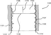
此外,从图16可容易地看出,路面的每一部分俘获于至少两个图像中。可看出由151b、152b及153b指示的区域的部分还将由从图15a到15c中所示的图像获得的经正射校正的图像覆盖。未显示但可容易推断出,区域151b、152b及153b的部分为来自继图15a到15c中所示的图像之后的图像的经正射校正的部分。然而在图15a到15c中所示的图像序列的图像中,汽车为可见,那些汽车在经正射校正的镶嵌图中不再可见。应注意,区域151a显示汽车的底架在正前方的暗组件。因为前述图像中的对应的地理区域显示除所述暗组件之外的组件,所以对应于所述暗组件的所述像素将标记为移动对象像素且将从道路色彩样本排除。Furthermore, as can be readily seen from Figure 16, each portion of the road surface is captured in at least two images. It can be seen that parts of the areas indicated by 151b, 152b and 153b will also be covered by orthorectified images obtained from the images shown in Figures 15a to 15c. Not shown but as can be easily inferred, portions of regions 151b, 152b and 153b are orthorectified portions from images subsequent to the images shown in Figures 15a to 15c. Whereas in the images of the sequence of images shown in Figures 15a to 15c the cars are visible, those cars are no longer visible in the orthorectified mosaic. Note that area 151a shows the undercarriage of the car as a dark component directly in front. Because the corresponding geographic area in the aforementioned image shows a component other than the dark component, the pixel corresponding to the dark component will be marked as a moving object pixel and will be excluded from the road color sample.
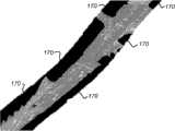
使用上述方法来产生表示路面色彩的道路色彩样本。从图15中所示的源图像及图16中所示的经正射校正的镶嵌图可见路面不具有均匀色彩。使用所述经正射校正的镶嵌图来确定道路信息,例如,道路宽度、车道宽度。上文揭示怎样将道路色彩样本用于确定哪些像素对应于路面且所述像素中的哪些不对应于路面。此外,上文描述可怎样针对每一像素确定其是固定像素还是移动对象像素。还使用这些方法来确定适于在经正射校正的镶嵌图中确定对应于路面的像素的道路色彩样本。可从与一个源图像中表示其上安装相机的移动车辆前方的路面的预界定区域相关联的像素确定道路色彩样本。然而,如果所述预界定区域中的路面不包括阴影,那么所述道路色彩样本将不把对应于有阴影的路面的像素指派给将针对经正射校正的镶嵌图产生的路面图像。因此,在本发明的实施例中,从多于一个连续图像确定所述道路色彩样本。所述道路色彩样本可对应于经正射校正的图像中用于解释经正射校正的镶嵌图的预界定区域中存在的所有像素值。在另一实施例中,所述道路色彩样本对应于经正射校正的镶嵌图的预界定区域中存在的所有像素值,其中所述预界定区域包括跟随移动车辆的轨迹线160的条纹中的所有像素。所述轨迹线可在所述条纹的中间,但应在所述条纹中的某处。因此获得的道路色彩样本将几乎包括路面的所有色彩值,从而使得所述应用能够在经正射校正的镶嵌图中几乎正确地检测对应于路面的所有像素且获得可从其确定道路信息(例如,道路边缘的位置)的路面图像。The method described above is used to generate a road color sample representing the color of the road surface. From the source image shown in Figure 15 and the orthorectified mosaic shown in Figure 16 it can be seen that the road surface does not have a uniform color. The orthorectified mosaic is used to determine road information, eg road width, lane width. The above discloses how road color samples are used to determine which pixels correspond to road surfaces and which of the pixels do not correspond to road surfaces. Furthermore, the above describes how it can be determined for each pixel whether it is a fixed pixel or a moving object pixel. These methods are also used to determine road color samples suitable for determining pixels corresponding to road surfaces in the orthorectified mosaic. Road color samples may be determined from pixels associated with a predefined area in one source image representing the road surface in front of the moving vehicle on which the camera is mounted. However, if the road surface in the predefined area does not include shadows, the road color sample will not assign pixels corresponding to the shaded road surface to the road surface image to be generated for the orthorectified mosaic. Thus, in an embodiment of the invention, said road color samples are determined from more than one consecutive image. The road color samples may correspond to all pixel values present in a predefined area in the orthorectified image for interpreting the orthorectified mosaic. In another embodiment, the road color samples correspond to all pixel values present in a predefined area of the orthorectified mosaic, wherein the predefined area includes the all pixels. The trajectory line can be in the middle of the stripe, but should be somewhere in the stripe. The road color samples thus obtained will include almost all color values of the road surface, enabling the application to detect almost correctly all pixels corresponding to the road surface in the orthorectified mosaic and obtain road information from which it can be determined (e.g. , the location of the road edge) road image.
在实施例中,已从预界定区域中的固定像素确定了道路色彩样本并移动对象像素被排除在外。在此实例中,所述道路色彩样本仅包括预定区域中未被分类为移动对象像素的像素的色彩值。以此方式,所述道路色彩样本更好地表示路面的色彩。In an embodiment, road color samples have been determined from fixed pixels in a predefined area and moving object pixels are excluded. In this instance, the road color samples include only color values of pixels in the predetermined area that are not classified as moving object pixels. In this way, the road color samples better represent the color of the road surface.
图17显示图16的经正射校正的镶嵌图,其中路面图像在顶部。区域170指示未被分类为路面像素的像素的区域。分类为路面像素的像素在图17中为透明。形成区域170与图17中的透明区域之间的边界的像素将被指派为道路边缘像素且用于确定道路信息,例如道路边缘及道路中心线的位置。Figure 17 shows the orthorectified mosaic of Figure 16 with the road image on top.
应注意,经正射校正的镶嵌图为源图像中表示移动车辆前方的预界定区域的区域的合成物。因此,从所述经正射校正的镶嵌图产生的路面图像为源图像中表示移动车辆前方的预界定区域的区域的合成物。It should be noted that the orthorectified mosaic is a composite of areas in the source image representing a predefined area in front of the moving vehicle. Thus, the road surface image generated from the orthorectified mosaic is a composite of the areas in the source images representing the predefined area in front of the moving vehicle.
当保证在俘获图像序列期间移动对象已存在于移动车辆前方的预界定区域中时,上述方法将适当地工作。然而,情况并不总是如此。在图16中,对应于源图像2的镶嵌图部分包括阴影。对应于所述阴影的色彩值可导致路面图像的不适当产生。因此,如上文所述,针对用于产生所述道路色彩样本的每一像素确定其是对应于固定像素还是移动对象像素。The method described above will work properly when it is guaranteed that the moving object has been present in the predefined area in front of the moving vehicle during the capture of the sequence of images. However, this is not always the case. In FIG. 16, the portion of the mosaic corresponding to source
针对经正射校正的镶嵌图,将产生对应的图像(亦即,移动对象图像),从而针对每一像素识别所述经正射校正的镶嵌图中的对应像素是固定像素还是移动对象像素。接着仅使用跟随移动车辆的轨迹线的条纹中的像素的像素值来获得道路色彩样本并将排除所述条纹中分类为移动对象像素的所有像素。以此方式,仅使用在所述图像序列的两个后续图像中识别为固定像素的像素的像素值来获得道路色彩样本。此将改善道路色彩样本的质量且因此路面图像的质量。For the orthorectified mosaic, a corresponding image (ie, moving object image) will be generated identifying for each pixel whether the corresponding pixel in the orthorectified mosaic is a fixed pixel or a moving object pixel. The road color samples are then obtained using only the pixel values of pixels in the stripes following the trajectory line of the moving vehicle and all pixels classified as moving object pixels in the stripes are excluded. In this way, road color samples are obtained using only the pixel values of pixels identified as fixed pixels in two subsequent images of the sequence of images. This will improve the quality of the road color samples and thus the quality of the road image.
当应用上述移动对象检测时,对应于阴影的像素将因在图像序列的先前图像中而被识别为移动对象像素,经正射校正的图像中的对应的像素将显示移动车辆前方的车辆,其色彩明显不同于有阴影的路面。When applying the moving object detection described above, the pixel corresponding to the shadow will be identified as a moving object pixel because it was in the previous image of the image sequence, and the corresponding pixel in the orthorectified image will show the vehicle in front of the moving vehicle, which The color is noticeably different from the shaded pavement.
移动对象图像可进一步用于改善对应于经正射校正的镶嵌图的路面图像中道路边缘的位置的确定。前文描述一种用于改善的方法。The moving object image can further be used to improve the determination of the location of the road edge in the road surface image corresponding to the orthorectified mosaic. The foregoing describes a method for improvement.
在大多数情况中,道路区段或沿轨迹并不是直的。图16显示稍微弯曲道路。可使用众所周知的曲线拟合算法来确定路面图像中道路边缘的位置且随后道路边缘的地理位置。可从曲线拟合算法道路排除被分类为移动对象像素的道路边缘像素。In most cases, road segments or along trajectories are not straight. Figure 16 shows a slightly curved road. Well known curve fitting algorithms can be used to determine the location of the road edge in the road surface image and then the geographic location of the road edge. Road edge pixels classified as moving object pixels may be excluded from the curve fitting algorithm road.
显示,根据本发明的方法可应用于经正射校正的图像及经正射校正的镶嵌图两者上。在两种情况中,从与一个或一个以上源图像中表示移动车辆前方的路面的预界定区域相关联的像素确定道路色彩样本,所述预界定区域包含所述移动车辆的轨迹线。此外,从一个或一个以上源图像依据道路色彩样本产生路面图像,且依据所述路面图像以及与源图像相关联的位置和定向数据产生道路信息。It is shown that the method according to the invention can be applied both on orthorectified images and on orthorectified mosaics. In both cases, road color samples are determined from pixels associated with a predefined area in one or more source images representing a road surface in front of a moving vehicle, the predefined area including a trajectory line of the moving vehicle. Additionally, road surface images are generated from road color samples from one or more source images, and road information is generated from the road surface images and position and orientation data associated with the source images.
对于两种类型的图像,优选地首先针对每一像素确定其是固定像素还是移动对象像素。为此,使用两个连续源图像内的共用区域,其中当被投影于相同平面上时,所述共用区域在所述图像中的每一者中表示路面的相似地理区域。接着,使用此信息来仅排除对应于移动对象的像素使其不确定道路色彩样本且改善用于产生道路信息的方法。For both types of images, it is preferable to first determine for each pixel whether it is a fixed pixel or a moving object pixel. To this end, a common area within two consecutive source images is used, which, when projected onto the same plane, represents a similar geographical area of the road surface in each of the images. This information is then used to exclude only pixels corresponding to moving objects from determining road color samples and improve the method for generating road information.
应注意,如果仅使用一个源图像来产生道路信息,那么可使用所述源图像来确定道路色彩样本并产生二进制路面图像。从所述二进制路面图像,可检索道路边缘像素。借助道路边缘像素以及相关联的位置和定向数据,可确定平行于行驶方向的最佳线。可使用将源图像转换为经正射校正的图像的公式来确定源图像中平行于行驶方向的线。It should be noted that if only one source image is used to generate road information, that source image can be used to determine road color samples and generate a binary road surface image. From the binary road image, road edge pixels may be retrieved. Using road edge pixels and associated position and orientation data, an optimal line parallel to the direction of travel can be determined. Lines parallel to the direction of travel in the source image can be determined using the formula that converts the source image to an orthorectified image.
图18图解说明根据本发明的方法在应用于一个源图像上时的实施例。图18显示弯曲道路180及车辆181的轨迹线。可借助与图像序列相关联的位置和定向数据在图像中确定所述车辆的轨迹线。使用轨迹线181来确定所述图像中表示移动车辆前方的路面的预界定区域182。线183指示预界定区域182的外部线。区域182在真实世界中为具有预界定宽度的条纹,其具有平行于车辆181的轨迹线的两个侧。可见区域182延伸直到所述车辆前方的预界定距离。使用预界定区域182中像素的所有值来获得道路色彩样本。使用所有色彩值来将每一像素分类为路面像素或非路面像素且产生对应的路面图像。线184图解说明对应于路面180的右侧的道路边缘像素,且线185图解说明对应于路面180的左侧的道路边缘像素。可使用曲线拟合算法来确定道路边缘的曲线及中心线曲线,未显示所述曲线。借助与所述图像相关联的位置和定向数据,可计算道路边缘及中心线的坐标。Figure 18 illustrates an embodiment of the method according to the invention when applied to a source image. FIG. 18 shows a
当可保证没有汽车在所述车辆正前方时,根据本发明的方法将仅对一个图像工作。如果不能保证此,那么可如上文所述通过在后续图像中使用预界定区域182的一部分中的共用区域在所述部分中确定对应于移动对象的像素。The method according to the invention will only work on one image when it can be guaranteed that no car is directly in front of the vehicle. If this cannot be guaranteed, the pixels corresponding to the moving object may be determined in a portion of the
借助上文所述的方法,可确定道路的中心线的绝对位置。此外,可确定路边的绝对位置及指示所述路边相对于中心线的相对位置的道路宽度。这些所确定的道路信息存储在供在地图数据库中使用的数据库中。可使用所述道路信息来在导航系统中产生路面的更现实视图。例如,可显形道路的变窄。此外,所述数据库中道路的宽度可极有益于确定用于可被太窄道路阻碍的例外运输的最佳路线。By means of the method described above, the absolute position of the centerline of the road can be determined. Furthermore, the absolute position of the curb and the road width indicative of the relative position of the curb to the centerline may be determined. This determined road information is stored in a database for use in the map database. The road information can be used to generate a more realistic view of the road in a navigation system. For example, the narrowing of a road can be visualized. Furthermore, the width of roads in the database can be extremely useful in determining optimal routes for exceptional transport that may be hindered by roads that are too narrow.
图14图解说明可用于实施执行上述方法的道路信息产生器的计算机系统的高阶框图。Figure 14 illustrates a high-level block diagram of a computer system that may be used to implement a road information generator that performs the methods described above.
图14的计算机系统包含处理器单元1412及主存储器1414。处理器单元1412可含有单个微处理器,或可含有多个微处理器以供将所述计算机系统配置为多处理器系统。主存储器1414部分地存储指令及数据以供由处理器单元1412执行。如果本发明的方法全部或部分地在软件中实施,那么主存储器1414在操作时存储可执行代码。主存储器1414可包含动态随机存取存储器(DRAM)以及高速缓冲存储器库。The computer system of FIG. 14 includes a processor unit 1412 and a main memory 1414 . Processor unit 1412 may contain a single microprocessor, or may contain multiple microprocessors for configuring the computer system as a multi-processor system. Main memory 1414 stores in part instructions and data for execution by processor unit 1412 . If the methods of the present invention are implemented in whole or in part in software, main memory 1414 stores executable codes when in operation. Main memory 1414 may include dynamic random access memory (DRAM) and cache banks.
图14的系统进一步包含大容量存储装置1416、外围装置1418、输入装置1420、便携式存储媒体驱动器1422、图形子系统1424及输出显示器1426。为简洁起见,将图14中所示的组件描绘为经由单个总线1428连接。然而,这些组件可通过一个或一个以上数据传输构件连接。例如,处理器单元1412及主存储器1414可经由本地微处理器总线连接,且大容量存储装置1416、外围装置1418、便携式存储媒体驱动器1422及图形子系统1424可经由一个或一个以上输入/输出(I/O)总线连接。大容量存储装置1416(其可借助磁盘驱动器或光盘驱动器实施)为用于存储数据的非易失性存储装置,这些数据例如相应相机的经地理编码的图像序列、相机的校准信息、恒定及变化位置参数、恒定及变化定向参数、经正射校正的图像块、道路色彩样本、所产生的道路信息以及供处理器单元1412使用的指令。在一个实施例中,大容量存储装置1416存储系统软件或计算机程序以供出于加载至主存储器1414的目的实施本发明。The system of FIG. 14 further includes
便携式存储媒体驱动器1422结合便携式非易失性存储媒体(例如,软盘、微驱动器及快闪存储器)操作以将数据及代码输入到图14的计算机系统且从图14的计算机系统输出数据及代码。在一个实施例中,用于实施本发明的系统软件以此便携式媒体的形式存储在处理器可读媒体上,且经由便携式存储媒体驱动器1422输入到所述计算机系统。外围装置1418可包含任一类型的计算机支持装置(例如,输入/输出(I/O)接口)以将额外功能添加到所述计算机系统。例如,外围装置1418可包含网络接口卡以供将计算机系统介接到网络、调制解调器等等。Portable storage media drive 1422 operates in conjunction with portable non-volatile storage media (eg, floppy disks, microdrives, and flash memory) to input data and code to and output data and code from the computer system of FIG. 14 . In one embodiment, system software for implementing the present invention is stored on a processor-readable medium in the form of such a portable medium and imported into the computer system via portable storage medium drive 1422 . Peripheral devices 1418 may include any type of computer support device, such as an input/output (I/O) interface, to add additional functionality to the computer system. For example, peripheral devices 1418 may include network interface cards for interfacing the computer system to a network, modems, and the like.
输入装置1420提供用户接口的一部分。输入装置1420可包含用于输入阿拉伯数字或其它键信息的阿拉伯数字键盘或指向装置(例如,鼠标、追踪球、触针或指针方向键)。为显示原文及图形信息,图14的计算机系统包含图形子系统1424及输出显示器1426。The input device 1420 provides part of the user interface. The input device 1420 may include an Arabic numeral keyboard or a pointing device (eg, a mouse, trackball, stylus, or pointer direction keys) for inputting Arabic numerals or other key information. To display textual and graphical information, the computer system of FIG. 14 includes a graphics subsystem 1424 and an output display 1426 .
输出显示器1426可包含阴极射线管(CRT)显示器、液晶显示器(LCD)或其它适宜的显示装置。图形子系统1424接收原文及图形信息,并处理所述信息以供输出到显示器1426。输出显示器1426可用于通过将所计算的中心线及道路边缘上覆在相关联的经正射校正的图像上来报告根据本发明的方法的结果、显示经正射校正的镶嵌图、显示方向、显示确认信息及/或显示是用户接口的一部分的其它信息。图14的系统还包含音频系统1428,其包含麦克风。在一个实施例中,音频系统1428包含从麦克风接收音频信号的声卡。另外,图14的系统包含输出装置1432。适宜的输出装置的实例包含扬声器、打印机等等。Output display 1426 may comprise a cathode ray tube (CRT) display, a liquid crystal display (LCD), or other suitable display device. Graphics subsystem 1424 receives textual and graphical information and processes the information for output to display 1426 . The output display 1426 can be used to report the results of the method according to the present invention, display the orthorectified mosaic, display the orientation, display Confirmation and/or display of other information that is part of the user interface. The system of FIG. 14 also includes an
图14的计算机系统中所含有的组件为通常在通用计算机系统中找到的那些组件,且打算表示在本计数中众所周知的这些计算机组件的宽广种类。The components contained in the computer system of FIG. 14 are those commonly found in general-purpose computer systems, and are intended to represent the broad variety of such computer components that are well known in this enumeration.
因此,图14的计算机系统可为个人计算机、工作站、小型计算机、大型计算机等等。所述计算机还可包含不同总线配置、网络式平台、多处理器平台等等。可使用各种操作系统,包含UNIX、Solaris、Linux、Windows、Macintosh OS及其它适宜的操作系统。Thus, the computer system of FIG. 14 may be a personal computer, a workstation, a minicomputer, a mainframe, and the like. The computer may also include different bus configurations, networked platforms, multi-processor platforms, and the like. Various operating systems can be used, including UNIX, Solaris, Linux, Windows, Macintosh OS, and other suitable operating systems.
可自动地执行上述方法。可能碰巧图像的质量使得执行本发明的图像处理工具及对象辨识工具需要某一校正。例如,相关联的经正射校正的图像块上的所计算的路边的叠加显示不想要的可见出发。在那一情况中,所述方法包含一些验证及手动调适动作以实现确认或调适中间结果的可能性。这些动作还可适于接受道路信息产生的中间结果或最终结果。此外,可使用一个或一个以上后续图像中有疑问标记的数目来请求人类执行验证。The method described above can be performed automatically. It may happen that the quality of the images is such that the image processing tools and object recognition tools implementing the present invention require some correction. For example, an overlay of calculated roadsides on the associated orthorectified image patch shows unwanted visible departures. In that case, the method includes some verification and manual adaptation actions to enable the possibility of confirming or adapting intermediate results. These actions may also be adapted to accept intermediate or final results generated by road information. Furthermore, the number of questionable markers in one or more subsequent images may be used to request a human to perform verification.
由本发明产生的道路信息针对每一图像产生道路信息并将其存储在数据库中。可进一步处理所述道路信息以减少信息的量。例如,对应于与道路区段相关联的图像的道路信息可针对所述区段的道路宽度减少为一个参数。此外,如果所述道路区段足够平滑,那么可用一组参数描述中心线,所述参数包含至少所述区段的端点及形状点。表示所述中心线的线可由多项式的系数存储。Road information generated by the present invention Road information is generated for each image and stored in a database. The road information may be further processed to reduce the amount of information. For example, road information corresponding to an image associated with a road segment may be reduced to one parameter for the road width of said segment. Furthermore, if the road segment is smooth enough, the centerline can be described with a set of parameters comprising at least the end points and shape points of the segment. A line representing said centerline may be stored by coefficients of a polynomial.
已出于图解说明及描述目的呈现了本发明的前述实施方式。并不打算穷尽列举本发明的形式或将本发明限于所揭示的确切形式,且显然鉴于以上教示许多修改及变化均可行。例如,替代记录移动车辆前方的路面的相机,可使用记录移动车辆后方的路面的相机。此外,本发明还适于确定经正射校正的图像中车道分隔带或其它线性道路标记的位置。The foregoing embodiments of the present invention have been presented for purposes of illustration and description. It is not intended to be exhaustive or to limit the invention to the precise form disclosed, and obviously many modifications and variations are possible in light of the above teaching. For example, instead of a camera recording the road ahead of the moving vehicle, a camera recording the road behind the moving vehicle may be used. Furthermore, the invention is also suitable for determining the position of lane dividers or other linear road markings in orthorectified images.
挑选所描述的实施例以便最佳地解释本发明的原理及其实际应用从而藉此使得所属领域的技术人员能够在各种实施例中且以适于所涵盖的特定应用的各种修改来最佳地利用本发明。本发明的范围打算由所附权利要求书加以界定。The embodiments described were chosen in order to best explain the principles of the invention and its practical application, thereby enabling others skilled in the art to optimize the invention in various embodiments and with various modifications as are suited to the particular application covered. The present invention is used to advantage. It is intended that the scope of the invention be defined by the appended claims.
Claims (14)
Translated fromChineseApplications Claiming Priority (3)
| Application Number | Priority Date | Filing Date | Title |
|---|---|---|---|
| PCT/NL2007/050159WO2008130219A1 (en) | 2007-04-19 | 2007-04-19 | Method of and apparatus for producing road information |
| NLPCT/NL2007/050159 | 2007-04-19 | ||
| PCT/NL2008/050228WO2008130233A1 (en) | 2007-04-19 | 2008-04-18 | Method of and apparatus for producing road information |
Publications (1)
| Publication Number | Publication Date |
|---|---|
| CN101689296Atrue CN101689296A (en) | 2010-03-31 |
Family
ID=38969352
Family Applications (1)
| Application Number | Title | Priority Date | Filing Date |
|---|---|---|---|
| CN200880017372APendingCN101689296A (en) | 2007-04-19 | 2008-04-18 | Method and apparatus for generating road information |
Country Status (8)
| Country | Link |
|---|---|
| US (1) | US20100086174A1 (en) |
| EP (1) | EP2137693A1 (en) |
| JP (1) | JP2010530997A (en) |
| CN (1) | CN101689296A (en) |
| AU (1) | AU2008241689A1 (en) |
| CA (1) | CA2684416A1 (en) |
| RU (1) | RU2009142604A (en) |
| WO (2) | WO2008130219A1 (en) |
Cited By (12)
| Publication number | Priority date | Publication date | Assignee | Title |
|---|---|---|---|---|
| WO2014110906A1 (en)* | 2013-01-18 | 2014-07-24 | 昆山市智汽电子科技有限公司 | Method and device for synthesizing and displaying panoramic image |
| CN105590087A (en)* | 2015-05-19 | 2016-05-18 | 中国人民解放军国防科学技术大学 | Road recognition method and device |
| CN105740826A (en)* | 2016-02-02 | 2016-07-06 | 大连楼兰科技股份有限公司 | A Binarization Detection Method for Lane Marking Based on Dual Scale |
| CN107305633A (en)* | 2016-04-19 | 2017-10-31 | 通用汽车环球科技运作有限责任公司 | Road feature detection using vehicle camera systems |
| CN108028883A (en)* | 2015-09-30 | 2018-05-11 | 索尼公司 | Image processing apparatus, image processing method and program |
| CN109064877A (en)* | 2018-08-20 | 2018-12-21 | 武汉中海庭数据技术有限公司 | Mutation center line smoothing method, device and storage medium based on high-precision map |
| CN109195832A (en)* | 2016-04-07 | 2019-01-11 | 西门子移动有限公司 | position determination system |
| CN109270927A (en)* | 2017-07-17 | 2019-01-25 | 高德软件有限公司 | The generation method and device of road data |
| CN109727334A (en)* | 2017-10-30 | 2019-05-07 | 长城汽车股份有限公司 | Recognition methods, device and the vehicle of landform locating for vehicle |
| CN110392892A (en)* | 2017-02-20 | 2019-10-29 | 大众汽车有限公司 | Method, corresponding system, and vehicle for generating segmented vehicle image data |
| CN110988888A (en)* | 2019-11-08 | 2020-04-10 | 中科长城海洋信息系统有限公司 | Method and device for acquiring seabed information |
| CN111275818A (en)* | 2018-12-04 | 2020-06-12 | 赫尔环球有限公司 | Method and apparatus for providing real-time feature triangulation |
Families Citing this family (58)
| Publication number | Priority date | Publication date | Assignee | Title |
|---|---|---|---|---|
| JP4531077B2 (en)* | 2007-05-31 | 2010-08-25 | 富士通テン株式会社 | Vehicle running state display device |
| WO2009064172A1 (en) | 2007-11-16 | 2009-05-22 | Tele Atlas B.V. | Method of and apparatus for producing lane information |
| JP5281424B2 (en)* | 2008-03-18 | 2013-09-04 | 株式会社ゼンリン | Road marking map generation method |
| JP5339753B2 (en)* | 2008-03-18 | 2013-11-13 | 株式会社ゼンリン | Road marking map generation method |
| JP5363752B2 (en)* | 2008-03-18 | 2013-12-11 | 株式会社ゼンリン | Road marking map generation method |
| JP5285311B2 (en)* | 2008-03-18 | 2013-09-11 | 株式会社ゼンリン | Road marking map generation method |
| US8803966B2 (en)* | 2008-04-24 | 2014-08-12 | GM Global Technology Operations LLC | Clear path detection using an example-based approach |
| US8421859B2 (en)* | 2008-04-24 | 2013-04-16 | GM Global Technology Operations LLC | Clear path detection using a hierachical approach |
| KR100886330B1 (en)* | 2008-06-11 | 2009-03-02 | 팅크웨어(주) | User view output system and method |
| TW201011259A (en)* | 2008-09-12 | 2010-03-16 | Wistron Corp | Method capable of generating real-time 3D map images and navigation system thereof |
| JP5324240B2 (en)* | 2009-01-29 | 2013-10-23 | 株式会社ゼンリン | Road marking map generation method and road marking map generation device |
| JP2010237797A (en)* | 2009-03-30 | 2010-10-21 | Equos Research Co Ltd | Image processing apparatus and image processing program |
| JP5359477B2 (en)* | 2009-04-07 | 2013-12-04 | 株式会社豊田中央研究所 | Road area estimation apparatus and program |
| WO2011047731A1 (en)* | 2009-10-22 | 2011-04-28 | Tele Atlas B.V. | Method for creating a mosaic image using masks |
| US9310245B2 (en)* | 2009-10-28 | 2016-04-12 | Csir | Integrated sensing device for assessing integrity of a rock mass and corresponding method |
| US8559673B2 (en)* | 2010-01-22 | 2013-10-15 | Google Inc. | Traffic signal mapping and detection |
| DE102010011093A1 (en)* | 2010-03-11 | 2011-09-15 | Daimler Ag | Method for determining a vehicle body movement |
| CN102905942B (en)* | 2010-03-25 | 2015-06-10 | 日本先锋公司 | Analog sound generating device and analog sound generating method |
| JP2012034196A (en)* | 2010-07-30 | 2012-02-16 | Olympus Corp | Imaging terminal, data processing terminal, imaging method, and data processing method |
| US8612138B2 (en)* | 2010-09-15 | 2013-12-17 | The University Of Hong Kong | Lane-based road transport information generation |
| WO2012034596A1 (en)* | 2010-09-16 | 2012-03-22 | Tomtom Polska Sp.Z.O.O. | Improvements in or relating to automatic detection of the number of lanes into which a road is divided |
| KR20120071160A (en)* | 2010-12-22 | 2012-07-02 | 한국전자통신연구원 | Method for manufacturing the outside map of moving objects and apparatus thereof |
| WO2012089261A1 (en)* | 2010-12-29 | 2012-07-05 | Tomtom Belgium Nv | Method of automatically extracting lane markings from road imagery |
| US9953618B2 (en) | 2012-11-02 | 2018-04-24 | Qualcomm Incorporated | Using a plurality of sensors for mapping and localization |
| JP2014219960A (en)* | 2013-04-08 | 2014-11-20 | トヨタ自動車株式会社 | Track detection device and track detection method |
| WO2015189847A1 (en)* | 2014-06-10 | 2015-12-17 | Mobileye Vision Technologies Ltd. | Top-down refinement in lane marking navigation |
| US9707960B2 (en) | 2014-07-31 | 2017-07-18 | Waymo Llc | Traffic signal response for autonomous vehicles |
| EP4254383A3 (en) | 2014-08-18 | 2023-12-20 | Mobileye Vision Technologies Ltd. | Recognition and prediction of lane constraints |
| CN104504103B (en)* | 2014-12-04 | 2018-05-15 | 中移全通系统集成有限公司 | A kind of track of vehicle point insertion performance optimization method and system, information acquisition device, database model |
| US9881384B2 (en)* | 2014-12-10 | 2018-01-30 | Here Global B.V. | Method and apparatus for providing one or more road conditions based on aerial imagery |
| JP6594039B2 (en) | 2015-05-20 | 2019-10-23 | 株式会社東芝 | Image processing apparatus, method, and program |
| CN105260699B (en)* | 2015-09-10 | 2018-06-26 | 百度在线网络技术(北京)有限公司 | A kind of processing method and processing device of lane line data |
| US10217363B2 (en)* | 2015-10-29 | 2019-02-26 | Faraday&Future Inc. | Methods and systems for electronically assisted lane entrance |
| US10365658B2 (en)* | 2016-07-21 | 2019-07-30 | Mobileye Vision Technologies Ltd. | Systems and methods for aligning crowdsourced sparse map data |
| JP7208708B2 (en)* | 2016-07-27 | 2023-01-19 | 株式会社エムアールサポート | Shape measurement method, apparatus, and program for three-dimensional measurement object |
| EP3285203A1 (en)* | 2016-08-19 | 2018-02-21 | Continental Automotive GmbH | Method for detecting a road in an environment of a vehicle |
| KR101864066B1 (en)* | 2017-01-11 | 2018-07-05 | 숭실대학교산학협력단 | Lane marking detection device, Lane departure determination device, Lane marking detection method and Lane departure determination method |
| US11200433B2 (en)* | 2017-05-03 | 2021-12-14 | Mobileye Vision Technologies Ltd. | Detection and classification systems and methods for autonomous vehicle navigation |
| US10140530B1 (en) | 2017-08-09 | 2018-11-27 | Wipro Limited | Method and device for identifying path boundary for vehicle navigation |
| US10373000B2 (en) | 2017-08-15 | 2019-08-06 | GM Global Technology Operations LLC | Method of classifying a condition of a road surface |
| US10895460B2 (en)* | 2017-11-06 | 2021-01-19 | Cybernet Systems Corporation | System and method for generating precise road lane map data |
| JP6466038B1 (en)* | 2018-03-01 | 2019-02-06 | 三菱電機株式会社 | Image processing apparatus and image processing method |
| CN108764187B (en) | 2018-06-01 | 2022-03-08 | 百度在线网络技术(北京)有限公司 | Method, device, equipment, storage medium and acquisition entity for extracting lane line |
| TWI682361B (en)* | 2018-12-14 | 2020-01-11 | 財團法人工業技術研究院 | Method and system for road image reconstruction and vehicle positioning |
| CN111507130B (en)* | 2019-01-31 | 2023-08-18 | 广州汽车集团股份有限公司 | Lane-level positioning method and system, computer equipment, vehicle, storage medium |
| US11288521B2 (en)* | 2019-01-31 | 2022-03-29 | Uatc, Llc | Automated road edge boundary detection |
| JP7310957B2 (en)* | 2019-06-07 | 2023-07-19 | トヨタ自動車株式会社 | MAP GENERATION DEVICE, MAP GENERATION METHOD AND MAP GENERATION COMPUTER PROGRAM |
| US11055543B2 (en) | 2019-07-26 | 2021-07-06 | Volkswagen Ag | Road curvature generation in real-world images as a method of data augmentation |
| JP7441509B2 (en)* | 2019-08-23 | 2024-03-01 | 株式会社エムアールサポート | Ortho image creation method, ortho image creation system, 3D model creation method, 3D model creation system, and sign used therefor |
| CN110728723B (en)* | 2019-09-23 | 2023-04-28 | 东南大学 | Automatic road extraction method for tile map |
| US11386649B2 (en) | 2019-11-15 | 2022-07-12 | Maxar Intelligence Inc. | Automated concrete/asphalt detection based on sensor time delay |
| CN111401251B (en)* | 2020-03-17 | 2023-12-26 | 北京百度网讯科技有限公司 | Lane line extraction method, lane line extraction device, electronic equipment and computer readable storage medium |
| KR20210148756A (en)* | 2020-06-01 | 2021-12-08 | 삼성전자주식회사 | Slope estimating apparatus and operating method thereof |
| CN113963324B (en)* | 2020-07-01 | 2025-08-08 | 希迪智驾科技股份有限公司 | Road boundary recognition method, device and electronic equipment |
| US12202432B2 (en)* | 2020-12-29 | 2025-01-21 | Nvidia Corporation | Restraint device localization |
| CN112732844B (en)* | 2021-01-26 | 2022-09-23 | 腾讯科技(深圳)有限公司 | Method, apparatus, device and medium for automatically associating road object with road |
| CN113139258B (en)* | 2021-04-28 | 2024-01-09 | 北京百度网讯科技有限公司 | Road data processing method, device, equipment and storage medium |
| CN117853677B (en)* | 2024-02-29 | 2024-06-21 | 腾讯科技(深圳)有限公司 | Road edge drawing method and device, electronic equipment and storage medium |
Family Cites Families (8)
| Publication number | Priority date | Publication date | Assignee | Title |
|---|---|---|---|---|
| US6209104B1 (en)* | 1996-12-10 | 2001-03-27 | Reza Jalili | Secure data entry and visual authentication system and method |
| WO2001015081A2 (en)* | 1999-08-20 | 2001-03-01 | Hebrew University Of Jerusalem | System and method for rectified mosaicing of images recorded by a moving camera |
| US6934860B1 (en)* | 2000-05-08 | 2005-08-23 | Xerox Corporation | System, method and article of manufacture for knowledge-based password protection of computers and other systems |
| US7389181B2 (en)* | 2004-08-31 | 2008-06-17 | Visre, Inc. | Apparatus and method for producing video drive-by data corresponding to a geographic location |
| US6928194B2 (en)* | 2002-09-19 | 2005-08-09 | M7 Visual Intelligence, Lp | System for mosaicing digital ortho-images |
| JP4578795B2 (en)* | 2003-03-26 | 2010-11-10 | 富士通テン株式会社 | Vehicle control device, vehicle control method, and vehicle control program |
| DE102005045017A1 (en)* | 2005-09-21 | 2007-03-22 | Robert Bosch Gmbh | Method and driver assistance system for sensor-based approach control of a motor vehicle |
| WO2008048579A2 (en)* | 2006-10-13 | 2008-04-24 | University Of Idaho | Method for generating and using composite scene passcodes |
- 2007
- 2007-04-19WOPCT/NL2007/050159patent/WO2008130219A1/enactiveApplication Filing
- 2008
- 2008-04-18CNCN200880017372Apatent/CN101689296A/enactivePending
- 2008-04-18AUAU2008241689Apatent/AU2008241689A1/ennot_activeAbandoned
- 2008-04-18JPJP2010504005Apatent/JP2010530997A/ennot_activeWithdrawn
- 2008-04-18RURU2009142604/08Apatent/RU2009142604A/ennot_activeApplication Discontinuation
- 2008-04-18USUS12/450,907patent/US20100086174A1/ennot_activeAbandoned
- 2008-04-18EPEP08741649Apatent/EP2137693A1/ennot_activeWithdrawn
- 2008-04-18CACA002684416Apatent/CA2684416A1/ennot_activeAbandoned
- 2008-04-18WOPCT/NL2008/050228patent/WO2008130233A1/enactiveApplication Filing
Cited By (16)
| Publication number | Priority date | Publication date | Assignee | Title |
|---|---|---|---|---|
| WO2014110906A1 (en)* | 2013-01-18 | 2014-07-24 | 昆山市智汽电子科技有限公司 | Method and device for synthesizing and displaying panoramic image |
| CN105590087A (en)* | 2015-05-19 | 2016-05-18 | 中国人民解放军国防科学技术大学 | Road recognition method and device |
| CN105590087B (en)* | 2015-05-19 | 2019-03-12 | 中国人民解放军国防科学技术大学 | A kind of road identification method and device |
| CN108028883A (en)* | 2015-09-30 | 2018-05-11 | 索尼公司 | Image processing apparatus, image processing method and program |
| CN108028883B (en)* | 2015-09-30 | 2020-11-03 | 索尼公司 | Image processing apparatus, image processing method, and program |
| CN105740826A (en)* | 2016-02-02 | 2016-07-06 | 大连楼兰科技股份有限公司 | A Binarization Detection Method for Lane Marking Based on Dual Scale |
| CN109195832A (en)* | 2016-04-07 | 2019-01-11 | 西门子移动有限公司 | position determination system |
| CN107305633A (en)* | 2016-04-19 | 2017-10-31 | 通用汽车环球科技运作有限责任公司 | Road feature detection using vehicle camera systems |
| CN110392892A (en)* | 2017-02-20 | 2019-10-29 | 大众汽车有限公司 | Method, corresponding system, and vehicle for generating segmented vehicle image data |
| CN110392892B (en)* | 2017-02-20 | 2023-05-12 | 大众汽车有限公司 | Method for generating segmented vehicle image data, corresponding system and vehicle |
| CN109270927A (en)* | 2017-07-17 | 2019-01-25 | 高德软件有限公司 | The generation method and device of road data |
| CN109727334A (en)* | 2017-10-30 | 2019-05-07 | 长城汽车股份有限公司 | Recognition methods, device and the vehicle of landform locating for vehicle |
| CN109064877A (en)* | 2018-08-20 | 2018-12-21 | 武汉中海庭数据技术有限公司 | Mutation center line smoothing method, device and storage medium based on high-precision map |
| CN109064877B (en)* | 2018-08-20 | 2020-12-29 | 武汉中海庭数据技术有限公司 | Abrupt center line smoothing method and device based on high-precision map and storage medium |
| CN111275818A (en)* | 2018-12-04 | 2020-06-12 | 赫尔环球有限公司 | Method and apparatus for providing real-time feature triangulation |
| CN110988888A (en)* | 2019-11-08 | 2020-04-10 | 中科长城海洋信息系统有限公司 | Method and device for acquiring seabed information |
Also Published As
| Publication number | Publication date |
|---|---|
| EP2137693A1 (en) | 2009-12-30 |
| WO2008130219A1 (en) | 2008-10-30 |
| AU2008241689A1 (en) | 2008-10-30 |
| US20100086174A1 (en) | 2010-04-08 |
| RU2009142604A (en) | 2011-05-27 |
| CA2684416A1 (en) | 2008-10-30 |
| WO2008130233A1 (en) | 2008-10-30 |
| JP2010530997A (en) | 2010-09-16 |
Similar Documents
| Publication | Publication Date | Title |
|---|---|---|
| CN101689296A (en) | Method and apparatus for generating road information | |
| US8325979B2 (en) | Method and apparatus for detecting objects from terrestrial based mobile mapping data | |
| US8422736B2 (en) | Method of and apparatus for producing lane information | |
| EP2092270B1 (en) | Method and apparatus for identification and position determination of planar objects in images | |
| US8847982B2 (en) | Method and apparatus for generating an orthorectified tile | |
| EP2195613B1 (en) | Method of capturing linear features along a reference-line across a surface for use in a map database | |
| US10438362B2 (en) | Method and apparatus for homography estimation | |
| HK1138094A (en) | Method of and apparatus for producing road information | |
| HK1133728A (en) | Method and apparatus for detecting objects from terrestrial based mobile mapping data | |
| HK1148377A (en) | Method of and apparatus for producing lane information | |
| HK1134131A (en) | Method and apparatus for identification and position determination of planar objects in images | |
| HK1142669A (en) | Method of capturing linear features along a reference-line across a surface for use in a map database | |
| HK1134540A (en) | Method and apparatus for generating an orthorectified tile |
Legal Events
| Date | Code | Title | Description |
|---|---|---|---|
| C06 | Publication | ||
| PB01 | Publication | ||
| C10 | Entry into substantive examination | ||
| SE01 | Entry into force of request for substantive examination | ||
| REG | Reference to a national code | Ref country code:HK Ref legal event code:DE Ref document number:1138094 Country of ref document:HK | |
| C02 | Deemed withdrawal of patent application after publication (patent law 2001) | ||
| WD01 | Invention patent application deemed withdrawn after publication | Open date:20100331 |