CN101685465B - Integrated three-dimensional data modeling method for comprehensive pipe network geographic information system - Google Patents
Integrated three-dimensional data modeling method for comprehensive pipe network geographic information systemDownload PDFInfo
- Publication number
- CN101685465B CN101685465BCN2009101158098ACN200910115809ACN101685465BCN 101685465 BCN101685465 BCN 101685465BCN 2009101158098 ACN2009101158098 ACN 2009101158098ACN 200910115809 ACN200910115809 ACN 200910115809ACN 101685465 BCN101685465 BCN 101685465B
- Authority
- CN
- China
- Prior art keywords
- network
- pipe network
- elements
- urban comprehensive
- comprehensive pipe
- Prior art date
- Legal status (The legal status is an assumption and is not a legal conclusion. Google has not performed a legal analysis and makes no representation as to the accuracy of the status listed.)
- Expired - Fee Related
Links
Images


Landscapes
- Information Retrieval, Db Structures And Fs Structures Therefor (AREA)
Abstract
Translated fromChineseDescription
Translated fromChinese技术领域technical field
本发明涉及计算机三维可视化技术领域,尤其涉及一种用于城市综合管网的三维数据建模方法。The invention relates to the technical field of computer three-dimensional visualization, in particular to a three-dimensional data modeling method for urban comprehensive pipe network.
背景技术Background technique
城市各类地下管网是城市基础设施的重要组成部分,它就像人体内的神经和血管,日夜担负着传递信息和输送能量的工作,是城市赖以生存和发展的物质基础,被称为城市的生命线。All kinds of underground pipe networks in cities are an important part of urban infrastructure. They are like nerves and blood vessels in the human body. They are responsible for transmitting information and energy day and night. They are the material basis for the survival and development of cities. They are called The lifeline of the city.
近20多年来我国城市建设有了飞速发展,城市原有的地下管网已远远满足不了现代化发展的需要,旧管网的更新、新管网的规划、新管网的设计施工都需要准确掌握地下管网的现状,而地下管网的管理主要存在以下两方面的问题:一方面,由于大部分管线处于地下、埋设较深、分布广泛、种类繁多、结构复杂,各种资料的数据量大,资料保存期长,这给管网的设计与管理带来巨大难题;另一方面,当前,我国城市地下管网的管理和研究工作总体来看还是相当落后的,现有的地下专业管网资料都是以图纸、图表等形式记录保存,大部分地区仍以手工方式进行管网的设计和管理,工作效率低,且不能提供准确的综合管线信息,无法满足城市建设、规划及城市管理部门对管网信息的要求,在一定程度上制约了国民经济的发展,由于地下管网管理技术手段落后而造成的损失是巨大的。因此,研究和建立地下管网地理信息系统,采用高技术手段来集中规划地下管网,使其规划、建设、管理、维护逐步走向定量化、科学化、自动化,满足决策部门和施工单位的需要已成为当务之急。实现管网信息的数字化、科学化和现代化管理是摆在我国城市管理工作面前的一项重要而紧迫的任务。In the past 20 years, China's urban construction has developed rapidly. The original underground pipe network in the city is far from meeting the needs of modern development. The renewal of the old pipe network, the planning of the new pipe network, and the design and construction of the new pipe network all need accurate Grasp the current situation of the underground pipeline network, and the management of the underground pipeline network mainly has the following two problems: on the one hand, because most pipelines are underground, buried deep, widely distributed, various in variety, and complex in structure, the data volume of various materials The large size and long data retention period bring huge problems to the design and management of the pipeline network; on the other hand, at present, the management and research work of China's urban underground pipeline Network data are recorded and kept in the form of drawings, charts, etc. Most areas still design and manage the pipeline network manually, which has low work efficiency and cannot provide accurate comprehensive pipeline information, which cannot meet the needs of urban construction, planning and urban management. The department's requirements for pipe network information have restricted the development of the national economy to a certain extent, and the losses caused by backward underground pipe network management technology are huge. Therefore, research and establish the underground pipeline network geographic information system, use high-tech means to centrally plan the underground pipeline network, make its planning, construction, management, and maintenance gradually quantitative, scientific, and automatic, and meet the needs of decision-making departments and construction units has become a priority. Realizing digital, scientific and modern management of pipe network information is an important and urgent task in front of our country's urban management.
数据模型是对客观事物及其联系的数据描述,GIS数据模型是GIS的灵魂和关键,反映了人们对客观世界的理解。GIS作为一种信息系统,是以现实世界为研究目标,以计算机内部的二进制数字世界作为存储载体的。它将人们对于客观世界的理解,经过一系列处理后变成数字形式存于计算机中。现实世界极其复杂,一方面人们希望GIS包含充足的数据,另一方面又期望从中能方便地选择所需要的相关数据而撇开其它无用的数据。因此,合理的开发城市综合管网的数据模型是实现三维可视化管网系统的基础,本申请正是基于上述问题而进行的研究。The data model is the data description of objective things and their connections, and the GIS data model is the soul and key of GIS, reflecting people's understanding of the objective world. As an information system, GIS takes the real world as the research target and uses the binary digital world inside the computer as the storage carrier. It converts people's understanding of the objective world into digital form and stores it in the computer after a series of processing. The real world is extremely complex. On the one hand, people hope that GIS contains sufficient data, and on the other hand, they hope that they can conveniently select the relevant data they need and leave other useless data aside. Therefore, the rational development of the data model of the comprehensive urban pipeline network is the basis for realizing the three-dimensional visualized pipeline network system, and this application is based on the above-mentioned problems.
发明内容Contents of the invention
本发明就是为了解决现有技术的不足而提出的一种能够较好解决城市基础设施特别是城市综合管网一体化管理问题的三维数据建模方法。The present invention proposes a three-dimensional data modeling method that can better solve the problem of integrated management of urban infrastructure, especially urban comprehensive pipe network, in order to solve the deficiencies of the prior art.
为了达到上述发明目的,本发明采用的技术方案为:一种用于综合管网地理信息系统的一体化三维数据建模方法,其包括下述步骤:In order to achieve the above-mentioned purpose of the invention, the technical solution adopted in the present invention is: an integrated three-dimensional data modeling method for the integrated pipeline network geographic information system, which includes the following steps:
(1)、对城市综合管网要素进行抽象,所述的城市综合管网的要素包括地理网络链、地理网络结点、中心、站、拐角和障碍,并对其相应的属性进行设定;(1), abstract the elements of the urban comprehensive pipeline network, the elements of the urban comprehensive pipeline network include geographical network chains, geographical network nodes, centers, stations, corners and obstacles, and set their corresponding attributes;
(2)、构建城市综合管网的变化事件,所述的城市综合管网的变化事件包括城市综合管网的属性、物理特性以及发生在网络上的偶然现象、突发事件;(2), build the change event of urban comprehensive pipe network, the change event of described urban comprehensive pipe network includes the attribute of urban comprehensive pipe network, physical characteristics and the occasional phenomenon that occurs on the network, sudden event;
(3)、构建城市综合管网要素拓扑关系,所述的拓扑关系包括城市综合管网要素间的关联、邻接关系;(3), construct the topological relationship of urban comprehensive pipe network elements, the topological relationship includes the association and adjacency relationship between the urban comprehensive pipe network elements;
(4)、根据城市综合管网本质特征与规律建立城市综合管网要素语义关系模型;(4), according to the essential characteristics and laws of the urban comprehensive pipeline network, establish the semantic relationship model of the urban comprehensive pipeline network elements;
(5)、建立城市综合管网物理数据模型,通过城市综合管网数据的物理组织,实现上述几何数据模型与属性数据、关系的关联。(5) Establish a physical data model of the urban comprehensive pipeline network, and realize the association of the above geometric data model with attribute data and relationships through the physical organization of the urban comprehensive pipeline network data.
更进一步地,步骤(1)中,所述的城市综合管网要素抽象为基本图形元素和网络要素,所述的基本图形要素包括点、线;所述的网络要素为在基本图元上增加描述现实中地理网络的属性。Further, in step (1), the described urban comprehensive pipeline network elements are abstracted into basic graphic elements and network elements, and the described basic graphic elements include points and lines; the described network elements are added on the basic graphic elements Describe properties of real-world geographic networks.
所述的点元素包括结点(node)和点(dot),线元素包括弧段(arc)、折线(poly line)和区段(route)。The point elements include nodes and dots, and the line elements include arcs, poly lines and routes.
所述的网络要素包括简单要素、复合要素,简单要素为点类型或线类型,并包括动态分段下的路径要素;所述的复合要素由简单要素或其它复合要素构成。The network elements include simple elements and compound elements, the simple elements are point type or line type, and include path elements under dynamic segmentation; the compound elements are composed of simple elements or other compound elements.
步骤(2)中,所述的事件在空间上分为点事件和线事件,所述的点事件的具体位置或线事件的起止位置采用线性参照的方法,即已知位置点+线性偏移量表示。In step (2), the event is spatially divided into a point event and a line event, and the specific position of the point event or the start and end position of the line event adopts a linear reference method, that is, a known position point+linear offset Quantity said.
步骤(5)中,进一步包括:In step (5), further comprising:
对于点状地理特征而言,存储该点状地理特征定位点X、Y、Z,每个数值由一个32位整数存储;For a point-like geographic feature, store the location point X, Y, and Z of the point-like geographic feature, and each value is stored by a 32-bit integer;
对于线状地理特征,该字段存储组成该特征的点的总数、弧段的个数、弧段对应点的个数及每个点的坐标值,其中每个数值由一个32位整数存储;For linear geographic features, this field stores the total number of points that make up the feature, the number of arcs, the number of points corresponding to the arcs, and the coordinates of each point, where each value is stored by a 32-bit integer;
对于管网数据中的面状地理特征,该字段存储组成该特征的多边形的个数、多边形的点数和其对应点坐标,其中每个数值由一个32位整数存储。For the area geographic feature in the pipe network data, this field stores the number of polygons that make up the feature, the number of points of the polygon and the coordinates of its corresponding points, where each value is stored by a 32-bit integer.
本发明具有如下优点:本发明所提供的三维数据模型建模方法,达到了在城市综合管网数据模型系统上的统一性,满足城市综合管网对动态信息的表达需求,值得推广应用。The present invention has the following advantages: the three-dimensional data model modeling method provided by the present invention achieves the unity of the urban comprehensive pipeline network data model system, meets the expression requirements of the urban comprehensive pipeline network for dynamic information, and is worthy of popularization and application.
附图说明Description of drawings
附图1是本发明的城市综合管网一体化三维数据模型的总体结构示意图;Accompanying
附图2是本发明的城市综合管网要素抽象示意图;Accompanying
附图3是本发明的城市综合管网事件的功能示意图;Accompanying
附图4是本发明的城市综合管网要素拓扑关系示意图;Accompanying
附图5是本发明的城市综合管网要素语义关系示意图;Accompanying drawing 5 is a schematic diagram of the semantic relationship of urban comprehensive pipe network elements of the present invention;
附图6是本发明的城市综合管网物理数据模型示意图。Accompanying drawing 6 is the schematic diagram of the physical data model of urban comprehensive pipe network of the present invention.
具体实施方式Detailed ways
下面结合附图对本发明的具体实施方式作进一步详细的说明:Below in conjunction with accompanying drawing, specific embodiment of the present invention is described in further detail:
本发明用于综合管网地理信息系统的一体化三维数据建模方法,其主要包括如下步骤:The present invention is used for the integrated three-dimensional data modeling method of comprehensive pipeline network geographic information system, and it mainly comprises the following steps:
(1)、对城市综合管网要素进行抽象,所述的城市综合管网的要素包括地理网络链、地理网络结点、中心、站、拐角和障碍,并对其相应的属性进行设定;(1), abstract the elements of the urban comprehensive pipeline network, the elements of the urban comprehensive pipeline network include geographical network chains, geographical network nodes, centers, stations, corners and obstacles, and set their corresponding attributes;
(2)、构建城市综合管网的变化事件,所述的城市综合管网的变化事件包括城市综合管网的属性、物理特性以及发生在网络上的偶然现象、突发事件;(2), build the change event of urban comprehensive pipe network, the change event of described urban comprehensive pipe network includes the attribute of urban comprehensive pipe network, physical characteristics and the occasional phenomenon that occurs on the network, sudden event;
(3)、构建城市综合管网要素拓扑关系,所述的拓扑关系包括城市综合管网要素间的关联、邻接关系;(3), construct the topological relationship of urban comprehensive pipe network elements, the topological relationship includes the association and adjacency relationship between the urban comprehensive pipe network elements;
(4)、根据城市综合管网本质特征与规律建立城市综合管网要素语义关系模型;(4), according to the essential characteristics and laws of the urban comprehensive pipeline network, establish the semantic relationship model of the urban comprehensive pipeline network elements;
(5)、建立城市综合管网物理数据模型,通过城市综合管网数据的物理组织,实现上述几何数据模型与属性数据、关系的关联。(5) Establish a physical data model of the urban comprehensive pipeline network, and realize the association of the above geometric data model with attribute data and relationships through the physical organization of the urban comprehensive pipeline network data.
通过上述步骤,可搭建出如图1所示的城市综合管网一体化三维数据模型的总体结构,下面将对每个步骤结合城市综合管网的具体环境因素进行详细的说明:Through the above steps, the overall structure of the integrated 3D data model of the urban comprehensive pipeline network as shown in Figure 1 can be built. The following will describe each step in detail in combination with the specific environmental factors of the urban comprehensive pipeline network:
一、根据实体在城市综合管网中的作用进行要素抽象,将城市综合管网的要素分为地理网链、地理结点、中心、站、拐角和障碍,且每一类要素都有相应的属性。其中,1. Abstract elements according to the role of entities in the urban comprehensive pipeline network, and divide the elements of the urban comprehensive pipeline network into geographical network chains, geographical nodes, centers, stations, corners and obstacles, and each type of element has a corresponding Attributes. in,
地理网络链是对现实世界中各种线状特征的抽象,是网络中资源流动交换的路线,可以代表机动路线、航道、输电线、供水管道等。网络链可以用各种线状元素(弧段、区段或路径)来表示,而不仅仅局限于弧段。网络链的属性信息有两种:一种是网络链的阻碍强度,如道路机动的时间、花费、危险性等;另一种是网络链的资源需求量,如供水管流量、燃气管气量等。The geographic network chain is an abstraction of various linear features in the real world, and it is the route of resource flow and exchange in the network, which can represent motor routes, waterways, power lines, water supply pipelines, etc. Network chains can be represented by various linear elements (arcs, sections or paths), not just limited to arcs. There are two kinds of attribute information of the network chain: one is the obstruction strength of the network chain, such as the time, cost, and danger of road maneuvering; the other is the resource demand of the network chain, such as the flow of water supply pipes, gas pipes, etc. .
网络链与网络链之间的连接点就是网络结点,它位于网络链两端,多条网络链通过网络结点建立联系。结点可以表示管线的交叉口、排水管道交汇点等。由于网络链不仅仅是弧段,因而网络的结点与弧段的结点可以一致,也可以不一致。网络结点属性信息包括网络流在结点处的阻抗,如果网络的结点参与资源分配,网络的结点也必须有一个资源需求量。根据实际需要,将其中一些结点设置为中心点、站点、拐角点和障碍等要素。The connection point between the network chain and the network chain is the network node, which is located at both ends of the network chain, and multiple network chains are connected through the network node. Nodes can represent intersections of pipelines, junctions of drainage pipes, etc. Since the network chain is not just an arc, the nodes of the network and the nodes of the arc can be consistent or not. The network node attribute information includes the impedance of the network flow at the node. If the network node participates in resource allocation, the network node must also have a resource requirement. According to actual needs, set some nodes as elements such as center point, station, corner point and obstacle.
中心是网络中具有一定的容量,能够从链上获取资源或发散资源的结点所在的位置。例如:储气罐具有一定的容量,能够容纳一定量的燃气,这些燃气再沿着不同的管道输送出去,因此储气罐就是燃气管网的一个中心;中心作为地理网络上资源集散的位置,它的属性至少包括该中心的需求量或供应量。The center is the location of nodes in the network that have a certain capacity and can obtain resources from the chain or diverge resources. For example: the gas storage tank has a certain capacity and can hold a certain amount of gas, which is then transported out along different pipelines, so the gas storage tank is a center of the gas pipeline network; the center is the location of resource distribution on the geographical network, Its attributes include at least the demand or supply of the center.
站是网络中拾起或卸下资源的结点位置,在最优路径分析和资源分配中都要用到站的属性。例如:水路运输中的码头、应急救援网络中的应急保障点。站的属性主要有两种,一种是站的阻碍强度,它代表与站有关的费用或阻碍,例如在码头装卸货物所用时间等;另一种属性是站的资源需求量,它表示资源在站上增加或减少的数量。站的需求量为正数时,表示在该站上拾起资源,反之,表示在该站上卸下资源。A station is a node position that picks up or unloads resources in the network, and its attributes are used in optimal path analysis and resource allocation. For example: docks in waterway transportation, emergency support points in emergency rescue networks. There are two main attributes of a station, one is the obstruction strength of the station, which represents the cost or obstruction related to the station, such as the time spent loading and unloading goods at the dock, etc.; the other attribute is the resource demand of the station, which indicates that resources are in The amount to increase or decrease on the station. When the demand of a station is a positive number, it means that resources are picked up on this station, otherwise, it means that resources are unloaded on this station.
拐角指网络中的网络结点上所有资源流动的可能转向。资源沿某一条链流到有关结点后,既可以原向返回,也可以流向与该结点相连的任意其它链。与网络的其它元素不同,拐角表示网络链之间的关系,而不是现实世界实体的抽象。然而,在现实网络中,拐角对资源的流动有很大的影响,例如在十字路口禁止车辆左拐等。拐角的主要属性是拐角的阻碍强度,它表示在一个结点处资源流向某一条链所需的时间或费用。阻碍强度值为负数时,表示资源禁止流向该弧段。A corner refers to a possible turn of all resource flows on a network node in a network. After the resource flows to the relevant node along a certain chain, it can either return in the original direction or flow to any other chain connected to the node. Unlike other elements of the network, corners represent relationships between network chains rather than abstractions of real-world entities. However, in real networks, corners have a great influence on the flow of resources, such as prohibiting vehicles from turning left at intersections, etc. The main property of a corner is the resistance strength of the corner, which represents the time or cost required for a resource to flow to a certain chain at a node. When the value of obstruction strength is negative, it means that resources are forbidden to flow to this arc.
障碍指网络资源不能通过的网络结点,阻碍了资源在与其相连的任意两条链之间流动。障碍不带任何属性,直接禁止网络链的可运行状态。由于地理网络不同应用和在各时间段的变化,有相当一部分属性需要动态跟踪管理。对属性的管理应满足以下几个要求:一个属性数据的变化,不影响其它任何属性数据;可以非常方便地增加和删除一个属性;应用中只处理感兴趣的属性,减少数据处理量和存储量;能够与实际应用的线性参照定位相结合。Obstacles refer to network nodes that network resources cannot pass through, preventing resources from flowing between any two chains connected to it. Barriers do not have any attributes and directly prohibit the runnable state of the network chain. Due to different applications of geographic networks and changes in various time periods, a considerable number of attributes require dynamic tracking and management. The management of attributes should meet the following requirements: the change of one attribute data does not affect any other attribute data; it is very convenient to add and delete an attribute; only the interested attributes are processed in the application, reducing the amount of data processing and storage ; Can be combined with linear reference positioning for practical applications.
具体实现分为两个步骤,首先建立基本的图形元素:点(point)、线(line)。点元素包括结点(node)和点(dot),线元素包括弧段(arc)、折线(poly line)和区段(route),这一层次中的元素包含了与要素相关的几何和拓扑信息,并且不包含现实的内涵。点和折线之间不显式表达拓扑关系,它们的拓扑关系可以通过坐标运算获得;结点和弧段间的拓扑关系全部显式地描述出来,但图形未经过平面强化,相交弧段之间不一定产生结点;区段通过从基本的线元素映射得到。The specific implementation is divided into two steps. Firstly, the basic graphic elements are established: point and line. Point elements include nodes (nodes) and points (dots), line elements include arcs (arc), polylines (poly lines) and sections (route), and elements in this level contain geometry and topology related to elements information and does not contain realistic connotations. The topological relationship between points and polylines is not explicitly expressed, and their topological relationship can be obtained through coordinate operations; the topological relationship between nodes and arcs is fully described explicitly, but the graphics are not plane-enhanced, and the intersecting arcs Nodes are not necessarily generated; segments are obtained by mapping from primitive line elements.
然后定义网络要素,在基本图元上增加描述现实中地理网络的属性,即对地理实体的空间特征以外的特性的描述。网络要素包括简单要素、复合要素。简单要素可能是点类型或线类型,并包括动态分段下的路径要素,简单要素可能描述拓扑关系或非拓扑关系。复合要素由简单要素或其它复合要素构成,可以定义拓扑关系(如复合要素的连通拓扑),无拓扑的简单要素不能聚合成复合要素。Then define the network elements, and add the attributes describing the geographical network in reality to the basic primitives, that is, the description of the characteristics other than the spatial characteristics of geographical entities. Network elements include simple elements and compound elements. Simple features may be of type point or line, and include route features under dynamic segmentation, and simple features may describe topological or non-topological relationships. Composite features are composed of simple features or other composite features, and can define topological relationships (such as the connected topology of composite features). Simple features without topology cannot be aggregated into composite features.
在拓扑方式下,一个拓扑点要素通常是通过一个结点来表示,一个拓扑边要素通过一条至多条的弧段或者区段来表示。在非拓扑方式下,要素通过基本元素点和折线来定义,一个非拓扑点要素是通过一个点来表示的,一个非拓扑线要素是通过一个折线来定义的,基本元素之间不定义任何拓扑关系。In the topology mode, a topological point feature is usually represented by a node, and a topological edge feature is represented by one or more arcs or segments. In non-topological mode, features are defined by basic elements points and polylines, a non-topological point feature is represented by a point, a non-topological line feature is defined by a polyline, and no topology is defined between basic elements relation.
区段本身不包含现实网络实体的内涵,由区段集组成的路径则增加了网络属性,可以表示地理网络的线性特征。路径反映了区段之间的连通拓扑关系,两条路径交叉不产生结点,即没有经过平面强化。路径有两方面作用,一方面表示城市综合管网线性要素,路径可以表达连续的、不连续的、带分支的线性要素;另一方面定义了线性参照基准,用于城市综合管网事件的定位。The segment itself does not contain the connotation of the actual network entity, but the path composed of the segment set adds network attributes, which can represent the linear characteristics of the geographic network. The path reflects the connected topological relationship between the sections, and the crossing of two paths does not generate nodes, that is, no plane reinforcement is performed. The path has two functions. On the one hand, it represents the linear elements of the urban comprehensive pipeline network. The path can express continuous, discontinuous, and branched linear elements; on the other hand, it defines a linear reference datum for the positioning of urban comprehensive pipeline network events. .
如图2所示,基础要素层由真实世界中具有确定位置的地物点和线段组成,仅在这一层更新几何数据,该层基于地理空间参照系,基础要素层是网络模型的基础,其它层均共享这一层的几何数据。应用要素层定义现实中的网络要素,包括简单要素(道路元素、供电线)和复杂要素(道路、立交桥、综合管沟),这一层的更新通过与底层的映射实现。As shown in Figure 2, the basic element layer is composed of feature points and line segments with definite positions in the real world. Only the geometric data is updated in this layer. This layer is based on the geographic spatial reference system. The basic element layer is the basis of the network model. All other layers share the geometric data of this layer. The application element layer defines the network elements in reality, including simple elements (road elements, power supply lines) and complex elements (roads, overpasses, integrated trenches). The update of this layer is realized through the mapping with the bottom layer.
线性参照层和事件层都是基于线性参照系,线性参照层定义了线性参照网络及线性参照方法,为事件层提供定位基准,路径是描述线性参照方法的主体,事件层中事件的定位通过沿路径的量测距离实现。Both the linear reference layer and the event layer are based on the linear reference system. The linear reference layer defines the linear reference network and the linear reference method, and provides a positioning reference for the event layer. The path is the main body describing the linear reference method. The measurement distance of the path is realized.
二、建立城市综合管网的变化事件,事件包括城市综合管网的属性、物理特性以及发生在网络上的偶然现象、突发事件等。2. The change events of the establishment of the urban comprehensive pipeline network. The events include the attributes and physical characteristics of the urban comprehensive pipeline network, as well as accidental phenomena and emergencies that occur on the network.
所述的事件是相对于基础地理网络要素在空间和时间上的变化,也属于城市综合管网要素,是对城市综合管网动态信息的表达,其同样以地理网络链、地理网络结点、中心、站、拐角和障碍的形式作用于城市综合管网系统。城市综合管网事件的属性信息包括事件的作用对象、引起的专题信息变化、空间特征和时间特征。The events described are changes in space and time relative to the basic geographic network elements, and also belong to the elements of the urban comprehensive pipeline network. They are the expression of dynamic information on the urban comprehensive pipeline network. The forms of centers, stations, corners and obstacles act on the urban comprehensive pipe network system. The attribute information of the urban comprehensive pipe network event includes the object of the event, the change of thematic information caused by the event, the spatial characteristics and the temporal characteristics.
事件的作用对象及引起的专题信息变化与城市综合管网应用领域相关,其代表城市综合管网应用时需要的信息及带来的影响。作用对象代表事件与基础网络要素的关系,引起的专题信息变化则是事件针对某个应用的属性。例如,城市防空人口疏散模型中人口疏散网络中的危险区、集结区及人防掩蔽工程作为依附于道路网络的点事件来处理。再如,城市道路网络中高架桥和隧道等的通行限高对部队沿道路机动的影响程度可作为点事件来表达,而受损的路段或行车宽度变化的路段对通行速度的影响可以作为线事件来处理。The object of the event and the change of thematic information caused by the event are related to the application field of the urban comprehensive pipeline network, which represents the information required for the application of the urban comprehensive pipeline network and the impact it brings. The action object represents the relationship between the event and the basic network elements, and the change of thematic information caused by the event is the attribute of the event for a certain application. For example, in the urban air defense population evacuation model, the danger zone, assembly area and civil air defense shelter project in the population evacuation network are treated as point events attached to the road network. For another example, the degree of influence of the height limit of viaducts and tunnels on the movement of troops along the road in the urban road network can be expressed as a point event, while the influence of damaged road sections or road sections with variable driving width on the passing speed can be expressed as a line event to deal with.
城市综合管网事件的空间特征表示事件发生的位置,沿网络线性要素定位事件,因此,从空间上可以将事件分为点事件和线事件。用事件点来描述点事件的具体位置或线事件的起止位置,采用线性参照的方法,即已知位置点+线性偏移量表示。如图3所示,站表中各条记录可作为点事件,管网质量表中各条记录可作为线事件。The spatial characteristics of urban comprehensive pipe network events represent the location of the event, and the event is located along the linear elements of the network. Therefore, events can be divided into point events and line events from space. Use the event point to describe the specific position of the point event or the start and end position of the line event, and use the linear reference method, that is, the known position point + linear offset to represent. As shown in Figure 3, each record in the station table can be regarded as a point event, and each record in the pipe network quality table can be regarded as a line event.
三、建立城市综合管网要素的拓扑关系,城市综合管网要素拓扑关系是建立起上述网络结构要素(结点、弧段)间的关联、邻接等关系,即要素之间的连通性或相邻的关系。关联是指不同类型要素之间的关系,邻接是指借助于不同类型的要素描述的相同拓扑要素之间的关系。3. Establish the topological relationship of the elements of the urban comprehensive pipeline network. The topological relationship of the elements of the urban comprehensive pipeline network is to establish the relationship, adjacency and other relationships between the above-mentioned network structure elements (nodes, arcs), that is, the connectivity or correlation between the elements. neighbor relationship. Association refers to the relationship between different types of elements, and adjacency refers to the relationship between the same topological elements described by means of different types of elements.
城市综合管网要素有两种表达方式。第一种方式是不考虑网络实体间的空间关系以实体本身作为管理、存储和处理的对象,例如道路不考虑线路交叉的情况将道路作为实体保存,这种做法保留了地理网络实体的完整性,数据结构简单,但无法进行网络分析,且实体之间的公共结点几何位置可能不一致。另一种方式是将完整的地理网络实体进一步进行离散,以点、线这两种基本元素类型来记录地理位置、表示地理现象,这种方式下,几何数据的离散存储使整体的线目标离散成了弧段,破坏了实体本身的整体性,因此要找出要素间的关系,完整地表达地理网络现象。There are two ways to express the urban comprehensive pipe network elements. The first way is to not consider the spatial relationship between network entities and use the entity itself as the object of management, storage and processing. For example, roads are saved as entities without considering the intersection of lines, which preserves the integrity of geographic network entities. , the data structure is simple, but network analysis cannot be performed, and the geometric positions of common nodes between entities may be inconsistent. Another way is to further discretize the complete geographic network entity, and use the two basic element types of point and line to record the geographic location and represent the geographical phenomenon. In this way, the discrete storage of geometric data makes the overall line object discrete It becomes an arc segment, which destroys the integrity of the entity itself. Therefore, it is necessary to find out the relationship between the elements and fully express the geographical network phenomenon.
采用离散的点、线表示城市综合管网,需要表达要素之间的拓扑关系,如图4所示为点、线之间的六种拓扑关系。拓扑关系的空间逻辑意义重于其几何意义,描述网络的拓扑关系有如下优点:Using discrete points and lines to represent the urban comprehensive pipe network needs to express the topological relationship between elements. Figure 4 shows six topological relationships between points and lines. The spatial logical meaning of the topological relationship is more important than its geometric meaning, and the description of the topological relationship of the network has the following advantages:
(a)拓扑关系反映了要素之间的逻辑结构关系,这种拓扑信息比几何位置有更大的稳定性。不需要利用坐标或距离,可以确定一种要素相对于另一个要素的空间位置关系。(a) The topological relationship reflects the logical structural relationship between elements, and this topological information is more stable than the geometric position. The spatial relationship of one feature relative to another can be determined without using coordinates or distances.
(b)利用拓扑关系便于查询要素点、线之间的连通性关系。(b) Use the topological relationship to facilitate the query of the connectivity relationship between feature points and lines.
(c)利用拓扑关系便于网络分析的进行。(c) Make use of topological relationships to facilitate network analysis.
四、对城市综合管网本质特征与规律的表达建立城市综合管网要素语义关系,传统数据模型主要侧重表达地理要素的几何特征,其语义关系和内部关系往往被忽视,语义关系的忽视实际上是对地理现象规律的忽视,在城市综合管网中,忽视语义关系会导致基于这种认识的数据模型在用于复杂的、深层次的网络分析时显得被动。在城市综合管网中,语义关系能够更好地保证数据质量,为模拟城市综合管网现象提供约束准则,从而能够通过计算机描述的空间实体真实地模拟现实的城市综合管网。4. To express the essential characteristics and laws of the urban comprehensive pipeline network and establish the semantic relationship of the elements of the urban comprehensive pipeline network. The traditional data model mainly focuses on expressing the geometric characteristics of geographical elements, and its semantic relationship and internal relationship are often ignored. The neglect of semantic relationship is actually It is the ignorance of the laws of geographical phenomena. In the urban comprehensive pipeline network, ignoring the semantic relationship will cause the data model based on this understanding to appear passive when used for complex and deep-level network analysis. In the urban integrated pipeline network, the semantic relationship can better guarantee the data quality and provide constraint criteria for simulating the phenomenon of the urban integrated pipeline network, so that the real urban integrated pipeline network can be truly simulated through the spatial entity described by the computer.
如图5所示,本发明城市综合管网要素的语义关系建模是城市综合管网领域知识表示的过程,是领域知识各组成单元的抽象,语义关系包括知识和规则,知识是可以序列化存储到数据表中的规则,规则是知识作用的方式。通过对城市综合管网应用领域的研究,提取出城市发展规划中所关心的地理网络实体属性及其对城市发展规划的规律,并结合城市综合管网自身运行的领域规则,形成知识库,以规则的形式来约束城市综合管网要素行为。As shown in Figure 5, the semantic relationship modeling of urban comprehensive pipeline network elements in the present invention is the process of expressing the domain knowledge of urban comprehensive pipeline network, and is the abstraction of each component unit of domain knowledge. The semantic relationship includes knowledge and rules, and knowledge can be serialized The rules stored in the data table, the rules are the way knowledge works. Through the research on the application field of urban comprehensive pipeline network, the attributes of geographical network entities concerned in urban development planning and the laws of urban development planning are extracted, and combined with the field rules of urban comprehensive pipeline network operation, a knowledge base is formed. The form of rules to constrain the behavior of urban comprehensive pipe network elements.
将语义关系模型中的知识转化为规则,通过模型映射,转化为检验应用模型的检验规则,这样语义关系模型里的各类抽象关系就可以映射到应用模型中,应用模型中的语义关系违反了领域知识的抽象关系,能够被检查出来并给予正确的提示。Transform the knowledge in the semantic relational model into rules, and through model mapping, transform it into inspection rules for testing the application model, so that various abstract relations in the semantic relational model can be mapped to the application model, and the semantic relations in the application model violate the The abstract relationship of domain knowledge can be checked out and given correct hints.
规则在知识定义基础之上用于约束行为,本发明将规则分为以下几种类型:Rules are used to restrict behavior on the basis of knowledge definition, and the present invention divides rules into the following types:
(a)连通性的约束规则,指网络链和网络结点之间的连通规则,如判断道路网中两条道路相交时结点是十字路口、高架、立交还是隧道;(a) Constraint rules for connectivity, which refer to the connectivity rules between network chains and network nodes, such as judging whether the node is a crossroad, elevated, overpass or tunnel when two roads intersect in the road network;
(b)无关联的约束规则,指网络要素之间不可能存在的关系,如电力线与煤气管道不可以同位近距埋设;自来水管道与输油管道不可以交叉埋设;(b) Non-associated constraint rules refer to impossible relationships among network elements, for example, power lines and gas pipelines cannot be buried in the same position and close to each other; tap water pipelines and oil pipelines cannot be cross-buried;
(c)基于条件的约束规则,指如果条件满足才能触发某种事件或事物,如污水管线的埋设高程都有一定的限制,低于某一值时污水就无法排放;(c) Constraint rules based on conditions, which means that certain events or things can be triggered only if the conditions are met. For example, the buried elevation of sewage pipelines has a certain limit, and sewage cannot be discharged when it is lower than a certain value;
(d)计算的约束规则,指提供计算属性值,如车道宽度不仅决定车辆行驶的列数,而且影响到行进的速度。不同路面宽度允许的行车速度在不同铺面的道路上纵队行进的平均速度。(d) Computational constraint rules, which refer to the provision of calculated attribute values, such as lane width not only determines the number of columns that vehicles drive, but also affects the speed of travel. The allowable driving speed of different road widths is the average speed of traveling in column on roads with different pavements.
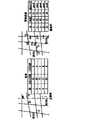
五、建立城市综合管网物理数据模型(physical data model),通过城市综合管网数据的物理组织,完成几何数据模型与属性数据、关系的关联。如图6所示,物理数据模型是反映数据存储结构的数据模型,是逻辑数据模型在计算机存储介质上的具体实现。物理数据模型不但与数据库管理系统有关,而且还与操作系统和硬件有关,通过城市综合管网数据的物理组织,完成几何数据模型与属性数据、关系的关联。5. Establish the physical data model of the urban comprehensive pipeline network, and complete the association of the geometric data model with attribute data and relationships through the physical organization of the urban comprehensive pipeline network data. As shown in Figure 6, the physical data model is a data model that reflects the data storage structure, and is the specific realization of the logical data model on the computer storage medium. The physical data model is not only related to the database management system, but also related to the operating system and hardware. Through the physical organization of the urban comprehensive pipeline network data, the association between the geometric data model and attribute data and relationships is completed.
管网数据库中图形数据库结构描述:Description of the graph database structure in the pipe network database:
如图6(a)对于点状地理特征而言,存储该点状地理特征定位点X、Y、Z,每个数值由一个32位整数存储。As shown in FIG. 6( a ), for a point-like geographic feature, the point X, Y, and Z of the point-like geographic feature are stored, and each value is stored by a 32-bit integer.
如图6(b)对于线状地理特征,该字段存储组成该特征的点的总数、弧段的个数、弧段对应点的个数及每个点的坐标值,其中每个数值由一个32位整数存储。As shown in Figure 6(b), for linear geographic features, this field stores the total number of points that make up the feature, the number of arcs, the number of points corresponding to the arcs, and the coordinates of each point, where each value consists of a 32-bit integer storage.
如图6(c)对于管网数据中的面状地理特征,该字段存储组成该特征的多边形的个数、多边形的点数和其对应点坐标,其中每个数值由一个32位整数存储。As shown in Figure 6(c), for the area-shaped geographic features in the pipe network data, this field stores the number of polygons that make up the feature, the number of points of the polygons, and the coordinates of their corresponding points, where each value is stored by a 32-bit integer.
管网数据的数据集模型采用图层管理(VectorLayer)、对象集(RenderObjectSet)、对象(RenderObject)等结构来描述。其中,“对象”指综合要素,它是所有管网三维场景中对象的基类。从该基类派生的对象主要包括网格、地形、管线要素、复杂物体、其他规则物体来描述。对象集是系统中要素集合的封装,每一个管网数据对象抽象为要素(MeshFeature),各种要素聚合为要素数据集(RenderObjectSet)统一由图层管理器(VectorLayer)来管理,其UML结构图如图6(d)。The data set model of pipe network data is described by layer management (VectorLayer), object set (RenderObjectSet), object (RenderObject) and other structures. Among them, "object" refers to comprehensive elements, which are the base class of objects in all pipe network 3D scenes. Objects derived from this base class mainly include grids, terrains, pipeline elements, complex objects, and other regular objects to describe. The object set is the encapsulation of the feature set in the system. Each pipe network data object is abstracted into a feature (MeshFeature), and various features are aggregated into a feature data set (RenderObjectSet), which is managed by a layer manager (VectorLayer). Its UML structure diagram As shown in Figure 6(d).
Claims (2)
Priority Applications (1)
| Application Number | Priority Date | Filing Date | Title |
|---|---|---|---|
| CN2009101158098ACN101685465B (en) | 2009-08-21 | 2009-08-21 | Integrated three-dimensional data modeling method for comprehensive pipe network geographic information system |
Applications Claiming Priority (1)
| Application Number | Priority Date | Filing Date | Title |
|---|---|---|---|
| CN2009101158098ACN101685465B (en) | 2009-08-21 | 2009-08-21 | Integrated three-dimensional data modeling method for comprehensive pipe network geographic information system |
Publications (2)
| Publication Number | Publication Date |
|---|---|
| CN101685465A CN101685465A (en) | 2010-03-31 |
| CN101685465Btrue CN101685465B (en) | 2011-12-21 |
Family
ID=42048629
Family Applications (1)
| Application Number | Title | Priority Date | Filing Date |
|---|---|---|---|
| CN2009101158098AExpired - Fee RelatedCN101685465B (en) | 2009-08-21 | 2009-08-21 | Integrated three-dimensional data modeling method for comprehensive pipe network geographic information system |
Country Status (1)
| Country | Link |
|---|---|
| CN (1) | CN101685465B (en) |
Families Citing this family (11)
| Publication number | Priority date | Publication date | Assignee | Title |
|---|---|---|---|---|
| CN104574505A (en)* | 2014-12-30 | 2015-04-29 | 华东师范大学 | Automatic three-dimensional pipeline communication modeling method |
| US10380272B2 (en) | 2015-04-30 | 2019-08-13 | International Business Machines Corporation | Update computer-implemented method, computer program product and computer system for generating or updating topology model of pressure pipe network |
| CN105069231A (en)* | 2015-08-11 | 2015-11-18 | 珠海格力电器股份有限公司 | Method and system for arranging centralized heat power pipe network |
| CN105335478B (en)* | 2015-10-10 | 2018-01-16 | 深圳市数字城市工程研究中心 | The method and apparatus for building urban land space multistory survey data semantic association |
| CN109256028B (en)* | 2018-08-28 | 2020-08-11 | 江苏久高电子科技有限公司 | A method for automatic generation of high-precision road network for unmanned driving |
| CN110020799B (en)* | 2019-03-28 | 2022-02-25 | 哈尔滨航天恒星数据系统科技有限公司 | Urban management grid resource allocation based on space-time reference |
| CN111105334A (en)* | 2019-12-30 | 2020-05-05 | 山东爱城市网信息技术有限公司 | A management method, equipment and medium for urban pipeline network based on blockchain |
| CN113392493B (en)* | 2020-03-11 | 2024-04-30 | 中国科学院国家空间科学中心 | Construction of digital earth magnetic layer and space-time calculation method based on digital earth magnetic layer |
| CN112948518B (en)* | 2021-03-05 | 2024-05-14 | 苍穹数码技术股份有限公司 | Object processing method, device, electronic equipment and computer storage medium |
| CN113609238A (en)* | 2021-07-24 | 2021-11-05 | 全图通位置网络有限公司 | Hadoop platform-based geographic entity spatial data processing method and storage medium |
| CN118364149A (en)* | 2023-01-17 | 2024-07-19 | 建设综合勘察研究设计院有限公司 | Data processing method and device for urban management event, electronic equipment and storage medium |
Citations (2)
| Publication number | Priority date | Publication date | Assignee | Title |
|---|---|---|---|---|
| CN1595455A (en)* | 2004-06-30 | 2005-03-16 | 南京大学 | Real-time three-dimensional geology modeling method based on GIS and virtual reality |
| CN101082926A (en)* | 2007-07-03 | 2007-12-05 | 浙江大学 | Modeling approachused for trans-media digital city scenic area |
- 2009
- 2009-08-21CNCN2009101158098Apatent/CN101685465B/ennot_activeExpired - Fee Related
Patent Citations (2)
| Publication number | Priority date | Publication date | Assignee | Title |
|---|---|---|---|---|
| CN1595455A (en)* | 2004-06-30 | 2005-03-16 | 南京大学 | Real-time three-dimensional geology modeling method based on GIS and virtual reality |
| CN101082926A (en)* | 2007-07-03 | 2007-12-05 | 浙江大学 | Modeling approachused for trans-media digital city scenic area |
Non-Patent Citations (1)
| Title |
|---|
| 孙伟等.城市3维地理信息系统中场景的制图输出技术.《测绘通报》.2007,(第9期),第54页至第56页.* |
Also Published As
| Publication number | Publication date |
|---|---|
| CN101685465A (en) | 2010-03-31 |
Similar Documents
| Publication | Publication Date | Title |
|---|---|---|
| CN101685465B (en) | Integrated three-dimensional data modeling method for comprehensive pipe network geographic information system | |
| CN102169637B (en) | Dynamic route guidance method oriented to urban traffic | |
| CN101964084A (en) | Intelligent dynamic network structure modeling and processing method applied to urban integrated pipeline system | |
| CN112988946B (en) | Geographic entity database user customization method | |
| CN101608926A (en) | Multilevel multi-modal routing navigating method | |
| CN108564516A (en) | A kind of urban planning decision support system | |
| Jang et al. | CityGML urban model generation using national public datasets for flood damage simulations: A case study in Korea | |
| CN102214230A (en) | Method for setting drainage pipeline network database | |
| CN108053458A (en) | A kind of watershed generalization figure based on GIS-Geographic Information System makes and methods of exhibiting | |
| CN101425238B (en) | The Method of Building Transportation Geographical Information System | |
| CN109034570A (en) | Cultural heritage protection method | |
| Vishnu et al. | Semantic modeling of utility networks implementation of use cases for Dehradun city | |
| WO2024223836A1 (en) | Grid-based analysis of environments | |
| CN118799147A (en) | A method, product, medium and equipment for dynamic mutual feedback property flood avoidance placement | |
| Boersma | Modelling different levels of detail of roads and intersections in 3D city models | |
| CN102495856A (en) | Generating method of pedestrian business district based on electronic map | |
| Yanbing et al. | On 3D GIS spatial modeling | |
| Ghosh et al. | Graph theory applications in advanced geospatial research | |
| Yanbing | 3D GIS spatial modeling for city surface and subsurface integration | |
| Titenko et al. | Multilayer geoinformation data access and representation model | |
| Mekni | Holonic virtual geographic environments | |
| Wang et al. | Two-dimensional Automatic Smooth Road Representation and Vehicle Trajectory based on key nodes for Complex Intersection Modeling | |
| CN110428613A (en) | A kind of intelligent transportation trend prediction method of machine learning | |
| Ryu et al. | Data Model Design of Underground Utilities Using General Feature Model in Korea. | |
| Jun et al. | A 3-dimensional data model for visualizing cloverleaf junction in a city model |
Legal Events
| Date | Code | Title | Description |
|---|---|---|---|
| C06 | Publication | ||
| PB01 | Publication | ||
| C10 | Entry into substantive examination | ||
| SE01 | Entry into force of request for substantive examination | ||
| C14 | Grant of patent or utility model | ||
| GR01 | Patent grant | ||
| CF01 | Termination of patent right due to non-payment of annual fee | ||
| CF01 | Termination of patent right due to non-payment of annual fee | Granted publication date:20111221 |