CN101517367B - Method, system and apparatus for distributing sorted map correction data - Google Patents
Method, system and apparatus for distributing sorted map correction dataDownload PDFInfo
- Publication number
- CN101517367B CN101517367BCN200780034481.6ACN200780034481ACN101517367BCN 101517367 BCN101517367 BCN 101517367BCN 200780034481 ACN200780034481 ACN 200780034481ACN 101517367 BCN101517367 BCN 101517367B
- Authority
- CN
- China
- Prior art keywords
- map
- category
- corrections
- distributing
- users
- Prior art date
- Legal status (The legal status is an assumption and is not a legal conclusion. Google has not performed a legal analysis and makes no representation as to the accuracy of the status listed.)
- Active
Links
Images


Classifications
- G—PHYSICS
- G01—MEASURING; TESTING
- G01C—MEASURING DISTANCES, LEVELS OR BEARINGS; SURVEYING; NAVIGATION; GYROSCOPIC INSTRUMENTS; PHOTOGRAMMETRY OR VIDEOGRAMMETRY
- G01C21/00—Navigation; Navigational instruments not provided for in groups G01C1/00 - G01C19/00
- G01C21/26—Navigation; Navigational instruments not provided for in groups G01C1/00 - G01C19/00 specially adapted for navigation in a road network
- G—PHYSICS
- G01—MEASURING; TESTING
- G01C—MEASURING DISTANCES, LEVELS OR BEARINGS; SURVEYING; NAVIGATION; GYROSCOPIC INSTRUMENTS; PHOTOGRAMMETRY OR VIDEOGRAMMETRY
- G01C21/00—Navigation; Navigational instruments not provided for in groups G01C1/00 - G01C19/00
- G01C21/38—Electronic maps specially adapted for navigation; Updating thereof
- G01C21/3804—Creation or updating of map data
- G01C21/3859—Differential updating map data
- G—PHYSICS
- G01—MEASURING; TESTING
- G01C—MEASURING DISTANCES, LEVELS OR BEARINGS; SURVEYING; NAVIGATION; GYROSCOPIC INSTRUMENTS; PHOTOGRAMMETRY OR VIDEOGRAMMETRY
- G01C21/00—Navigation; Navigational instruments not provided for in groups G01C1/00 - G01C19/00
- G01C21/26—Navigation; Navigational instruments not provided for in groups G01C1/00 - G01C19/00 specially adapted for navigation in a road network
- G01C21/34—Route searching; Route guidance
- G01C21/3407—Route searching; Route guidance specially adapted for specific applications
- G01C21/3415—Dynamic re-routing, e.g. recalculating the route when the user deviates from calculated route or after detecting real-time traffic data or accidents
- G—PHYSICS
- G01—MEASURING; TESTING
- G01C—MEASURING DISTANCES, LEVELS OR BEARINGS; SURVEYING; NAVIGATION; GYROSCOPIC INSTRUMENTS; PHOTOGRAMMETRY OR VIDEOGRAMMETRY
- G01C21/00—Navigation; Navigational instruments not provided for in groups G01C1/00 - G01C19/00
- G01C21/26—Navigation; Navigational instruments not provided for in groups G01C1/00 - G01C19/00 specially adapted for navigation in a road network
- G01C21/34—Route searching; Route guidance
- G01C21/36—Input/output arrangements for on-board computers
- G01C21/3667—Display of a road map
- G01C21/367—Details, e.g. road map scale, orientation, zooming, illumination, level of detail, scrolling of road map or positioning of current position marker
- G—PHYSICS
- G01—MEASURING; TESTING
- G01C—MEASURING DISTANCES, LEVELS OR BEARINGS; SURVEYING; NAVIGATION; GYROSCOPIC INSTRUMENTS; PHOTOGRAMMETRY OR VIDEOGRAMMETRY
- G01C21/00—Navigation; Navigational instruments not provided for in groups G01C1/00 - G01C19/00
- G01C21/38—Electronic maps specially adapted for navigation; Updating thereof
- G01C21/3804—Creation or updating of map data
- G01C21/3833—Creation or updating of map data characterised by the source of data
- G01C21/3837—Data obtained from a single source
- G—PHYSICS
- G01—MEASURING; TESTING
- G01C—MEASURING DISTANCES, LEVELS OR BEARINGS; SURVEYING; NAVIGATION; GYROSCOPIC INSTRUMENTS; PHOTOGRAMMETRY OR VIDEOGRAMMETRY
- G01C21/00—Navigation; Navigational instruments not provided for in groups G01C1/00 - G01C19/00
- G01C21/38—Electronic maps specially adapted for navigation; Updating thereof
- G01C21/3804—Creation or updating of map data
- G01C21/3833—Creation or updating of map data characterised by the source of data
- G01C21/3856—Data obtained from user input
- G—PHYSICS
- G01—MEASURING; TESTING
- G01C—MEASURING DISTANCES, LEVELS OR BEARINGS; SURVEYING; NAVIGATION; GYROSCOPIC INSTRUMENTS; PHOTOGRAMMETRY OR VIDEOGRAMMETRY
- G01C21/00—Navigation; Navigational instruments not provided for in groups G01C1/00 - G01C19/00
- G01C21/38—Electronic maps specially adapted for navigation; Updating thereof
- G01C21/3885—Transmission of map data to client devices; Reception of map data by client devices
- G—PHYSICS
- G06—COMPUTING OR CALCULATING; COUNTING
- G06Q—INFORMATION AND COMMUNICATION TECHNOLOGY [ICT] SPECIALLY ADAPTED FOR ADMINISTRATIVE, COMMERCIAL, FINANCIAL, MANAGERIAL OR SUPERVISORY PURPOSES; SYSTEMS OR METHODS SPECIALLY ADAPTED FOR ADMINISTRATIVE, COMMERCIAL, FINANCIAL, MANAGERIAL OR SUPERVISORY PURPOSES, NOT OTHERWISE PROVIDED FOR
- G06Q50/00—Information and communication technology [ICT] specially adapted for implementation of business processes of specific business sectors, e.g. utilities or tourism
- G06Q50/01—Social networking
Landscapes
- Engineering & Computer Science (AREA)
- Radar, Positioning & Navigation (AREA)
- Remote Sensing (AREA)
- Physics & Mathematics (AREA)
- General Physics & Mathematics (AREA)
- Automation & Control Theory (AREA)
- Business, Economics & Management (AREA)
- Marketing (AREA)
- General Business, Economics & Management (AREA)
- Economics (AREA)
- General Health & Medical Sciences (AREA)
- Human Resources & Organizations (AREA)
- Computing Systems (AREA)
- Primary Health Care (AREA)
- Strategic Management (AREA)
- Tourism & Hospitality (AREA)
- Health & Medical Sciences (AREA)
- Theoretical Computer Science (AREA)
- Navigation (AREA)
- Instructional Devices (AREA)
- Traffic Control Systems (AREA)
- Information Retrieval, Db Structures And Fs Structures Therefor (AREA)
- Management, Administration, Business Operations System, And Electronic Commerce (AREA)
- Information Transfer Between Computers (AREA)
Abstract
Description
Translated fromChinese技术领域technical field
本发明涉及一种产生用于导航装置中的改进地图数据的方法。导航装置包括基于GPS的电子个人导航装置。The invention relates to a method of generating improved map data for use in navigation devices. Navigation devices include GPS-based electronic personal navigation devices.
背景技术Background technique
用于例如基于GPS的个人导航装置的电子导航装置(如购自汤姆汤姆国际公司(TomTom International BV)的GOTM)的地图数据来自于例如特勒·阿特莱斯公司(TeleAtlas NV)的专业地图供应商。此地图数据经特别设计以由通常使用来自GPS系统的位置数据的路线引导算法使用。举例来说,可将道路描述为线,即向量(例如,道路的起点、终点、方向,其中整个道路由数百个此类段组成,每一段由起点/终点方向参数唯一地定义)。接着,地图为所述道路向量、与每一向量相关联的数据(速度限制;行进方向等等)加上关注点(point of interest,POI)加上道路名称加上如公园边界、河流边界等其他地理特征(以上所有均以向量方式定义)的集合。所有地图特征(例如,道路向量、POI等等)通常定义于对应于GPS坐标系统或与GPS坐标系统相关的坐标系统中,使得如通过GPS系统确定的装置位置能够定位到地图中所示的相关道路上且能够实现计划到目的地的最佳路线。Map data for electronic navigation devices such as GPS-based personal navigation devices (such as the GO™ from TomTom International BV) comes from specialized companies such as TeleAtlas NV. map provider. This map data is specifically designed to be used by route guidance algorithms that typically use location data from GPS systems. For example, a road can be described as a line, ie a vector (eg start, end, direction of a road, where the whole road consists of hundreds of such segments, each uniquely defined by a start/end direction parameter). The map then adds points of interest (POIs) plus road names plus eg park boundaries, river boundaries, etc. A collection of other geographic features (all of the above are defined as vectors). All map features (e.g., road vectors, POIs, etc.) are generally defined in a coordinate system corresponding to or related to the GPS coordinate system, so that the device position, as determined by the GPS system, can be located in relation to that shown in the map. on the road and able to achieve the best route planned to the destination.
为了建构此地图数据库,特勒·阿特莱斯(Tele Atlas)以来自各种来源(例如英国地形测量局(Ordnance Survey))的关于英国道路的基本道路信息着手。其还具有在道路上行驶的庞大、专用的车辆团队,加上检查其他地图及航空照片的人员来更新并检查其数据。此数据组成特勒·阿特莱斯(Tele Atlas)地图数据库的核心。此地图数据库正不断地通过地理参考数据而得以增强。接着,一年四次检查所述数据库并将其公布给如汤姆汤姆(TomTom)的装置制造商。To construct this map database, Tele Atlas started with basic road information about UK roads from various sources such as the Ordnance Survey. It also has a large, dedicated fleet of vehicles on the road, plus people reviewing other maps and aerial photos to update and check its data. This data forms the core of the Tele Atlas map database. This map database is continuously enhanced with georeferenced data. The database is then checked four times a year and published to device manufacturers such as TomTom.
尽管存在参与更新及验证这些地图的巨大资源,但关于一些地理区的数据仍可能过时一年或更久。Although there are enormous resources involved in updating and validating these maps, data on some geographic areas may still be a year or more out of date.
除了上文所述的正在进行的改进,最终用户还可使用特勒·阿特莱斯(TeleAtlas)的网站直接向特勒·阿特莱斯(Tele Atlas)报告地图错误。如汤姆汤姆(TomTom)的装置制造商也可以此方式捕获并转发来自其用户的地图错误报告。这些错误报告一般仅采取自由文字格式,因此需将大量精力消耗于弄清楚错误具有何真正意义及其与何确切位置有关。一旦检验为真实错误,则证实适当校正且接着将其包括于未来的地图版本中。校正可能在首次被通知后的一年或更久之后最终出现于最终用户装置中,或者在一些情况中根本不出现于最终用户装置中。In addition to the ongoing improvements described above, end users can report map errors directly to Tele Atlas using TeleAtlas' website. Device manufacturers such as TomTom can also capture and forward map error reports from their users in this manner. These bug reports are generally only in free text format, so a lot of effort is expended in figuring out what the error really means and relates to where exactly. Once verified to be true errors, the appropriate corrections are verified and then included in future map versions. Corrections may end up in the end-user device a year or more after first being notified, or in some cases not appear in the end-user device at all.
还已知可存储使用GPS卫星导航装置所计划并完成的行程的“迹线”(见(例如)由美国普林斯顿的ALK技术公司(ALK Technologies of Princeton,USA)提供的“GPS轨迹提交”功能)。此迹线为使用地理编码数据对车辆所采取的完整路线的记录。用户接着可将此迹线数据发送回到装置供应商;所述数据接着用以改进地图数据库的准确性及完整性。举例来说,道路或转弯的精确位置在装置所使用的地图上可能未经准确捕获;采取所述道路或转弯的人的汇总轨迹将使得能够确定更为准确的位置;由装置供应商提供的未来地图版本可并入所述校正。It is also known to store "traces" of trips planned and completed using GPS satellite navigation devices (see, for example, the "GPS Track Submission" function provided by ALK Technologies of Princeton, USA) . This track is a record of the complete route taken by the vehicle using geocoded data. The user can then send this trace data back to the device supplier; the data is then used to improve the accuracy and completeness of the map database. For example, the precise location of a road or turn may not be accurately captured on the map used by the device; aggregated trajectories of persons taking said road or turn will enable a more accurate location to be determined; provided by the device supplier Future map versions may incorporate the corrections.
还可参考常被称为“维基地图(wikimap)”的合作地图绘制计划。然而,维基地图不以我们定义术语“地图数据”(即,适于由路线引导算法在道路系统上绘制到目的地的路线的地图数据)的形式来产生地图数据。Reference is also made to the collaborative mapping initiative often referred to as "wikimap". However, Wikimaps does not produce map data in the form in which we define the term "map data", ie map data suitable for drawing a route to a destination on a road system by a route guidance algorithm.
发明内容Contents of the invention
本发明为一种产生用于导航装置中的改进地图数据的方法,所述方法包含以下步骤:The present invention is a method of generating improved map data for use in a navigation device, said method comprising the steps of:
a)在电子导航装置上显示适用于路线引导算法的地图数据;a) Display map data suitable for route guidance algorithms on electronic navigation devices;
b)所述装置的最终用户直接在所述装置上输入对地图错误的校正;b) the end user of the device enters corrections to map errors directly on the device;
c)所述装置能够在未对所述校正进行外部处理的情况下使用所述校正。c) The device is able to use the correction without external processing of the correction.
因此,不再必要将最终用户限制于经由网络链接向地图供应商报告错误,接着等待地图供应商验证错误,更新其地图并供应更新,其为可花费数月且有时数年来完成的循环。替代地,导航装置可在无外部处理(例如,由地图供应商进行的验证)的情况下使用校正。装置对校正的使用可(相对地)为“立即的”。不应将术语“立即”解释为瞬间,而仅应解释为意味着已输入校正后不久。可存在介入步骤,例如用户验证应使用校正、开启装置且接着关闭装置等等。Thus, it is no longer necessary to limit end users to reporting errors via a network link to a map provider, then waiting for the map provider to verify the error, update its map, and supply the update, a cycle that can take months and sometimes years to complete. Alternatively, the navigation device may use the correction without external processing (eg verification by the map provider). Use of the correction by the device may be (relatively) "immediate." The term "immediately" should not be interpreted as instantaneous, but only as meaning shortly after the correction has been entered. There may be intervening steps such as the user verifying that the calibration should be used, turning the device on and then turning it off, and so on.
在一实施方案中,存在允许用户对存储于其装置上的地图数据进行修改的导航装置。导航装置可为例如购自汤姆汤姆国际公司(TomTom International BV)的GO系列装置的具有路线引导能力的便携式独立GPS导航装置,或例如移动电话或PDA的任何其他种类的便携式信息装置。但同样地,其可为集成到车辆中的装置,或例如静态桌上型PC(包括膝上型)的计算装置,其运行导航软件(所述术语包括实际上并不传递动态路线引导而是替代地仅绘制用户在何处的地图绘制软件。同样,导航软件可本地运行于客户端装置上或运行于远离客户端装置的服务器上)。PC接着可与具有路线引导能力的便携式导航装置对接且将校正传送到便携式导航装置。In one embodiment, there are navigation devices that allow users to make modifications to map data stored on their devices. The navigation device may be a portable stand-alone GPS navigation device with route guidance capabilities such as the GO series of devices available from TomTom International BV, or any other kind of portable information device such as a mobile phone or PDA. But equally, it could be a device integrated into the vehicle, or a computing device such as a static desktop PC (including laptops) that runs navigation software (the term includes Instead there is only mapping software that plots where the user is. Likewise, the navigation software can run locally on the client device or on a server remote from the client device). The PC can then interface with the portable navigation device with route guidance capabilities and communicate the corrections to the portable navigation device.
所述导航装置的典型特征为:Typical features of the navigation device are:
●允许用户建立对数字存储的地图的校正的用户接口;● A user interface that allows the user to establish corrections to digitally stored maps;
●允许用户将地图校正包括于路线计算中或排除于路线计算外的用户接口;- A user interface that allows the user to include or exclude map corrections in route calculations;
●允许用户在数字地图上观察其校正的地图数据的用户接口● A user interface that allows users to view their corrected map data on a digital map
●允许用户使地图校正与一个或一个以上运输类型相关联的一组校正类别;- A set of correction categories that allow users to associate map corrections with one or more transport types;
●与其他用户分享(例如经由内容汇总服务)地图校正的能力。分享的地图一经下载即可用(例如,通过路线计划算法或地图显示引擎)。- Ability to share (eg via a content aggregation service) map corrections with other users. Shared maps are made available once downloaded (for example, by a route planning algorithm or map display engine).
本发明的第二方面为自动地图校正提议方法:在此方法中,导航装置收集并分析与驾驶者行为相关的统计数据,且通常在满足某一阈值准则时向用户提议地图校正。举例来说,如果用户不转进装置计划的路线所沿的道路,其可能是由于实际道路存在“禁止进入”标志,但存储于装置上的地图并非最新。装置接着可自动显示例如“抱歉,地图是否错误?”的消息连同由消息所显示的“是”及“否”按钮。如果用户按下“是”,则装置接着可能显示允许用户建立对存储于装置上的地图的校正的用户接口。用户接着可通过将所述道路标记为“禁止进入”道路而校正地图。所述校正立即可用于运行于导航装置上的路线计划算法。A second aspect of the invention is an automatic map correction proposal method: In this method, the navigation device collects and analyzes statistical data related to driver behavior and proposes map corrections to the user, usually when a certain threshold criterion is met. For example, if the user does not turn onto the road along which the device's planned route is taken, it may be because there are "no entry" signs on the actual road, but the map stored on the device is not up to date. The device may then automatically display a message such as "Sorry, is the map wrong?" along with "Yes" and "No" buttons displayed by the message. If the user presses "Yes," the device may then display a user interface that allows the user to establish corrections to maps stored on the device. The user can then correct the map by marking the road as a "no entry" road. The corrections are immediately available to the route planning algorithm running on the navigation device.
第三方面为地图校正分析方法:在此方法中,系统使用以下动作中的一者或一者以上来分析地图校正:A third aspect is a map correction analysis method: In this method, the system analyzes map corrections using one or more of the following actions:
●对用户校正进行分析及汇总以导出校正的“有效性”;●Analyze and summarize user corrections to derive the "effectiveness" of corrections;
●分析由单一用户供应的校正以导出来自所述用户的校正的“可信赖度”;• Analyzing corrections supplied by a single user to derive a "trustworthiness" of corrections from said user;
●对所有串数据进行关键词分析以移除“禁止”词语(例如,街道名称中的咒骂语);Perform keyword analysis on all string data to remove "prohibited" words (e.g., expletives in street names);
●分析校正以决定是否应将地图校正应用于同一区域中的其他地图(来自于其他供应者的地图及来自同一供应者的地图的较新版本两者)。- Analyze corrections to decide if map corrections should be applied to other maps in the same area (both maps from other providers and newer versions of maps from the same provider).
附图说明Description of drawings
将参考附图描述本发明,在附图中The invention will be described with reference to the accompanying drawings, in which
图1为由导航装置显示的主错误报告屏幕;Figure 1 is the main error reporting screen displayed by the navigation device;
图2为展示允许用户定义其希望捕获及报告的错误类型的屏幕;Figure 2 shows a screen that allows users to define the types of errors they wish to capture and report;
图3为来自实施本发明的导航装置的屏幕截图;所述屏幕截图展示平面地图视图及沿显示器底部运行的状态栏;Figure 3 is a screenshot from a navigation device embodying the present invention; said screenshot showing a flat map view and a status bar running along the bottom of the display;
图4为来自实施3维视图的导航装置的屏幕截图;Figure 4 is a screenshot from a navigation device implementing a 3D view;
图5为来自导航装置的屏幕截图,其展示导航菜单;Figure 5 is a screenshot from a navigation device showing a navigation menu;
图6A及图6B为导航装置的透视图;及6A and 6B are perspective views of a navigation device; and
图7为导航装置的系统架构的示意图;7 is a schematic diagram of a system architecture of a navigation device;
图8为导航装置中的组件的框图;Figure 8 is a block diagram of components in a navigation device;
图9为图8的导航装置中的电子组合件的图。FIG. 9 is a diagram of an electronics assembly in the navigation device of FIG. 8 .
具体实施方式Detailed ways
将参考被称作地图分享TM(Map ShareTM)的实施方案来描述本发明。地图分享(MapShare)将允许用户使用购自汤姆汤姆国际公司(TomTom International B.V.)的GO个人导航装置来修正地图错误且还分享并报告地图错误。用户将校正(或地图修正)键入到导航装置中。接着在装置中本地应用地图修正来补充装置在路线选择及显示道路、POI等等中所使用的地图数据。地图修正立即可用。可由装置以如下的许多方式将地图修正报告给汤姆汤姆(TomTom)服务器:装置可具有一体通信能力(例如,可向服务器发送数据的无线蜂窝式系统);可经由短程无线链路将数据发送到移动电话(移动电话又将数据发送到服务器);可能够与一可与服务器通信的连接因特网的PC对接;或者可自身即为所述连接因特网的PC。服务器可接着汇总来自所有用户的所有校正、验证校正及将校正分发给其他用户,且与一个或一个以上地图供应商分享所述校正。The invention will be described with reference to an implementation known as MapShare™ . MapShare will allow users to fix map errors and also share and report map errors using a GO personal navigation device purchased from TomTom International BV. The user enters corrections (or map corrections) into the navigation device. Map corrections are then applied locally in the device to supplement map data used by the device in routing and displaying roads, POIs, and the like. Map corrections are available immediately. Map corrections can be reported by the device to the TomTom server in a number of ways: the device can have integral communication capabilities (e.g., a wireless cellular system that can send data to the server); data can be sent via a short-range wireless link to The mobile phone (which in turn sends data to the server); may be capable of interfacing with an Internet-connected PC that can communicate with the server; or may be the Internet-connected PC itself. The server can then aggregate all corrections from all users, validate and distribute corrections to other users, and share the corrections with one or more map providers.
在充分实施时,此反馈可替代地图供应商更新而作为用于更新汤姆汤姆(TomTom)产品中的地图数据的主要机制。When fully implemented, this feedback can replace map vendor updates as the primary mechanism for updating map data in TomTom products.
地图分享(Map Share)的一个实施方案的范围是提供用户友好的装置上工具,其允许用户:The scope of one embodiment of Map Share is to provide a user-friendly on-device tool that allows users to:
●在其地图上对街道进行封锁及解除封锁● Block and unblock streets on its map
●在其地图上修改街道的交通方向● Modify the traffic direction of the street on its map
●在其地图上添加及修改街道名称● Add and modify street names on their maps
●在其地图上修改道路的速度限制● Modify the speed limit of the road on its map
因此,校正直接影响路线选择计算算法如何操作,即,在计算到目的地的路线时使用所述校正。地图分享(Map Share)还允许用户:Thus, the correction directly affects how the routing calculation algorithm operates, ie it is used when calculating the route to the destination. Map Share also allows users to:
●将安全照相机位置添加到地图● Add security camera locations to the map
●与其他用户分享地图校正●Share map corrections with other users
●从其他用户下载地图校正●Download map corrections from other users
●针对重大错误建立地图错误报告。● Create map bug reports for major bugs.
除了装置上校正,还可通过使用能够连接到装置(例如)以存储校正的桌上型计算机应用程序而使得用于所有以上校正类型的相同校正特征可用。In addition to on-device corrections, the same correction features for all of the above correction types can also be made available through the use of a desktop computer application that can be connected to a device, for example, to store corrections.
除了装置上特征,也可对基于网络的现有汤姆汤姆(TomTom)地图错误报告工具进行改进:In addition to on-device features, improvements can also be made to the existing web-based TomTom Maps error reporting tool:
●将使得在汤姆汤姆(TomTom)支持网站内较易于找到地图错误报告● Will make map bug reports easier to find within the TomTom support site
●将向汤姆汤姆本地(TomTom Home)应用程序添加地图错误报告工具● A map error reporting tool will be added to the TomTom Home app
●用户将接收对其已报告的地图错误的反馈。● Users will receive feedback on map errors they have reported.
●汤姆汤姆(TomTom)将能够在将错误发送到其地图供应者(例如,特勒阿特莱斯(TeleAtlas))之前预先确定错误的优先次序。• TomTom will be able to pre-prioritize bugs before sending them to its map provider (eg TeleAtlas).
如早先所阐述,地图分享(Map Share)实施方案的重要特征为:As stated earlier, the important features of the Map Share implementation are:
●在装置上进行地图校正、错误报告等等● On-device map corrections, bug reporting, and more
●使得某些校正立即生效(例如,满足用户定义的准则的那些校正)Make certain corrections take effect immediately (eg, those that meet user-defined criteria)
●允许用户与其他用户交换校正● Allow users to exchange corrections with other users
在GO导航装置上,此可由装置显示如图1A所示的菜单项“对地图进行改变”而实施。在下文论述选择此项的结果。将首先描述2个其他菜单项。On a GO navigation device, this can be implemented by the device displaying the menu item "Make Changes to Map" as shown in Figure 1A. The consequences of selecting this are discussed below. Two other menu items will be described first.
第一,菜单项“交换改变”允许用户起始对用户自身改变的上载及下载其他人的改变到装置。上载可经由具有通过蓝牙网络链接到GO装置的GPRS无线链路的移动电话或经由与GO装置对接的连接因特网的PC而进行。First, the menu item "Exchange Changes" allows the user to initiate the upload of the user's own changes and download other people's changes to the device. Uploading can be done via a mobile phone with a GPRS wireless link to the GO device via a Bluetooth network or via an Internet connected PC docked with the GO device.
第二,菜单项“关于改变的偏好”确定启用哪些改变。选择此项可致使装置显示菜单屏幕,其具有复选框(check box)以供用户指示将启用的改变的可应用类型:Second, the menu item "Preferences about changes" determines which changes are enabled. Selecting this can cause the device to display a menu screen with check boxes for the user to indicate the applicable types of changes that will be enabled:
应启用哪些改变:Which changes should be enabled:
[x]您自身的改变[x] Your own changes
[x]最近的改变[x] Recent changes
上年度的改变/在其他地图上所作的改变Changes from previous year/changes made on other maps
[x]只有报告一次以上的改变[x] Only report changes more than once
[x]仅来自于受信任的来源的改变[x] Changes from trusted sources only
启用2635个可用改变中的1365个Enabled 1365 of 2635 available changes
如果用户通过触摸“对地图进行改变”图标而对其进行选择,则其将用户带到一子菜单,所述子菜单提供用以改变地图的即时生效(INSTANT-EFFECT)选项,加上用以报告(REPORT)错误的选项(如果报告未涵盖自动作中)。如图1B所示,这些选项包括:If the user selects the "make changes to map" icon by touching it, it takes the user to a sub-menu that provides INSTANT-EFFECT options to change the map, plus to Option to report (REPORT) errors (in action if not covered by report). As shown in Figure 1B, these options include:
●添加/改变街道名称:如果用户选择此选项,则装置可(例如)显示当前正由地图显示的街道名称的列表(或者如果装置处于正常导航模式中则将显示的列表);用户可选择待经重新命名的街道且接着经由屏幕上的键盘而键入新名称。Add/Change Street Names: If the user selects this option, the device may, for example, display a list of street names currently being displayed by the map (or the list that would be displayed if the device were in normal navigation mode); The renamed street and then type in the new name via the on-screen keyboard.
●封锁街道:如果用户选择此选项,则装置可(例如)显示当前正由地图显示的街道名称的列表(或者如果装置处于正常导航模式中则将显示的列表);用户可选择待被封锁的街道。Block Streets: If the user selects this option, the device may, for example, display a list of street names currently being displayed by the map (or the list it would display if the device were in normal navigation mode); street.
●改变交通方向(未图示):如果用户选择此选项,则装置可(例如)显示当前正由地图显示的街道名称的列表(或者如果装置处于正常导航模式中则将显示的列表)连同交通方向;用户可选择交通方向将被变更的街道。- Change traffic direction (not shown): If the user selects this option, the device may, for example, display a list of street names currently being displayed by the map (or the list that would be displayed if the device was in normal navigation mode) along with the traffic Direction; the user can select the street on which traffic direction will be changed.
●改变速度限制:如果用户选择此选项,则装置可(例如)显示当前正由地图显示的街道名称的列表(或者如果装置处于正常导航模式中则将显示的列表)连同可应用的速度限制;用户可选择街道限制将被变更的街道且接着从菜单选择适当的新速度限制。Change speed limit: if the user selects this option, the device may, for example, display a list of street names currently being displayed by the map (or the list it would display if the device was in normal navigation mode) along with applicable speed limits; The user can select the street where the street limit is to be changed and then select the appropriate new speed limit from the menu.
●对街道解除封锁:如果用户选择此选项,则装置可(例如)显示当前正由地图显示的受封锁街道名称的列表(或者如果装置处于正常导航模式中则将显示的列表);用户可选择待解除封锁的街道。Unblock Streets: If the user selects this option, the device may, for example, display a list of blocked street names that are currently being displayed by the map (or the list that would be displayed if the device were in normal navigation mode); the user may select Streets to be lifted.
另外,有可能在选择“编辑/删除POI”图标时到达较深层的子菜单,所述子菜单具有用于以下操作的图形选项:Additionally, it is possible to reach a deeper submenu when selecting the Edit/Delete POI icon, which has graphical options for:
对POI进行重新命名Rename the POI
移动POIMobile POI
向种类添加POIAdd POIs to categories
删除POIDelete POIs
对POI进行重新分类Reclassify POIs
在每一情况中,装置均可(例如)显示当前正由地图显示的POI名称的列表(或者如果装置处于正常导航模式中则将显示的列表);用户可选择相关POI且接着编辑或删除所述POI。这些POI通常为地图供应商所供应的那些POI,但可包括由用户下载的POI(例如,测速照相机(speed camera))。In each case, the device may, for example, display a list of POI names currently being displayed by the map (or the list it would display if the device were in normal navigation mode); the user may select the relevant POI and then edit or delete all Describe the POI. These POIs are typically those supplied by map providers, but may include POIs downloaded by users (eg, speed cameras).
另一菜单项为“报告其他错误”。此使得能够报告申诉、遗漏的道路等等。典型功能将使得用户能够挑选位置、从典型问题的列表选择,允许用户添加自由文字注解等等。Another menu item is "Report Other Bugs". This enables reporting of grievances, missing paths, etc. Typical functions would enable the user to pick a location, choose from a list of typical questions, allow the user to add free text annotations, and the like.
其他特征other features
●用户可建立对其地图的“私用”修正及也被发送到汤姆汤姆(TomTom)以供汇总的“分享”修正。• Users can create "private" fixes to their maps and "shared" fixes that are also sent to TomTom for aggregation.
●独立存储每一地图修正●Store each map correction independently
●所有地图修正对于OTA分发可高度压缩● All map fixes are highly compressible for OTA distribution
●所有地图修正高度安全(使得不可能对格式进行手动反向工程设计)以确保竞争者无法使用在汤姆汤姆(TomTom)装置上进行的修正来校正其自身的地图。• All map corrections are highly secure (making manual reverse engineering of the format impossible) to ensure that competitors cannot use corrections made on TomTom devices to correct their own maps.
●以独立于地图的形式来存储修正●Store corrections in a map-independent form
о在地图升级期间保存地图修正о Save map fixes during map upgrades
о可将地图修正应用于来自不同供应商的地图о Map corrections can be applied to maps from different suppliers
●如果与修正相关的区在地图数据的新版本中已改变,则可自动移除地图修正(因为在此情况下我们假设地图错误已由地图供应者修正)。• Map corrections may be automatically removed if the area to which the correction relates has changed in a new version of the map data (since in this case we assume that map errors have been corrected by the map provider).
●地图修正并不永久修改用户的地图数据。●Map correction does not permanently modify the user's map data.
●用户可选择其使用哪些种类的改变(例如,“仅使用本人的改变”或“使用本人的改变及来自汤姆汤姆(TomTom)的那些改变”)。• The user can choose which kinds of changes they use (eg "use only my changes" or "use my changes and those from TomTom").
●汤姆汤姆(TomTom)针对每一发布的地图版本均维护地图修正数据库(注意:具有新版地图的用户可接收关于较旧版地图所报告的修正,但旧版地图的用户将不能够接收关于较新版地图所报告的修正)。TomTom maintains a database of map corrections for each map version released (note: users with newer maps can receive corrections reported for older maps, but users of older maps will not be able to receive reported correction).
●汤姆汤姆(TomTom)建立汇总系统以使得可收集地图修正及报告且将其与其他用户分享。• TomTom builds an aggregation system so that map corrections and reports can be collected and shared with other users.
●汤姆汤姆(TomTom)建立“信任”系统以使得可对地图修正及报告的有效性或可信度进行评定。定期地报告有益错误的用户可变得“受信任”,且其修正无需验证即被提供给所有用户。还可请求这些用户验证由其他用户提交的修正。• TomTom establishes a "trust" system so that the validity or credibility of map corrections and reports can be rated. Users who regularly report beneficial bugs can become "trusted" and their fixes made available to all users without verification. These users can also be requested to validate fixes submitted by other users.
●汤姆汤姆(TomTom)认可由用户发送的修正(一旦其已得到证实)。• TomTom approves corrections sent by users (once they have been validated).
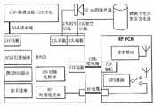
图2示意地展示部署于实施本发明的导航装置中的核心软件模块。显示器21为用户以常规方式键入目的地地址的触摸屏幕显示器。所述地址数据输入由UI模块22加以处置且发送到导航/路线计划模块23。路线计划模块23采用来自GPS模块24的GPS馈入并使用来自装置所配备的(或由例如特勒·阿特莱斯(Tele Atlas)的地图供应商以其他方式所供应的)经加密、经压缩的地图数据来计划路线。接着如下所述实施本发明:用户视需要且在需要时使用触摸屏幕互动、触摸较大图形图标(如由图1A及图1B所例示)而将地图校正键入到显示器21中。UI模块22捕获地图修正并将其发送到地图修正存储装置26。一旦地图修正处于地图修正存储装置26中,即刻使其对于路线计划模块22及UI模块22可用。如果地图修正要求对甚至正行驶的当前路线进行重新设计,则重新设计将自动发生(在用户配置了所述选项的情况下)。举例来说,装置可能计划要求用户转进街道的路线:当接近转弯时,用户发现其近来已成为“禁止进入”街道。用户可键入适当地图校正:接着立即计划一计及所述禁止进入街道的新路线且给出适当路线引导。同样,如果用户计划到另一目的地的全新路线,则新路线也将计及所述地图修正。如果地图修正将影响地图会如何展现(例如,对道路进行重新命名、展示例如测速照相机等新POI),则所述新外观将立即呈现。然而对于校正的自动使用并非强制性的;一些用户可能偏好于路线计算等等而排除地图校正。FIG. 2 schematically shows core software modules deployed in a navigation device implementing the present invention. The
附录1描述可实施本发明的典型装置。附录2为对于地图分享(Map Share)的高水平要求。
附录1
本发明可实施于购自汤姆汤姆公司(TomTom B.V.)的被称作GO的集成式导航装置中。GO部署有称作导航者(Navigator)(或导航核心(Navcore))的导航软件且具有内部GPS接收器;导航者(Navigator)软件还可运行于由触摸屏幕(即受指示笔控制)口袋式PC供电的PDA装置上,例如康柏公司(Compaq)的iPaq。在PDA与GPS接收器耦合时,其即可提供基于GPS的导航系统。此组合的PDA与GPS接收器系统经设计以用作车辆内导航系统。The invention may be implemented in an integrated navigation device called GO available from TomTom B.V. The GO deploys navigation software called Navigator (or Navcore) and has an internal GPS receiver; the Navigator software also runs on pocket PC-powered PDA devices, such as Compaq's iPaq. When a PDA is coupled with a GPS receiver, it provides a GPS-based navigation system. This combined PDA and GPS receiver system is designed for use as an in-vehicle navigation system.
还可以导航装置的任一其他布置而实施本发明,例如具有一体式GPS接收器/计算机/显示器的导航装置,或经设计以用于非车辆使用(例如,用于步行者)或除汽车以外的车辆(例如,飞机)的装置。导航装置可实施任何种类的位置感应技术且不限于GPS;因此可使用例如欧洲伽利略系统(European Galileo system)的其他种类的全球导航卫星系统(GNSS,global navigation satellite system)来实施所述导航装置。同样地,其不限于基于卫星的位置/速度系统,而是可使用基于地面的信标或使得装置能够确定其地理位置的任何其他种类的系统而部署。The invention can also be implemented in any other arrangement of navigation devices, such as ones with an integrated GPS receiver/computer/display, or designed for non-vehicular use (for example, for pedestrians) or other than automobiles A device for a vehicle (for example, an aircraft). The navigation device may implement any kind of position sensing technology and is not limited to GPS; thus other kinds of global navigation satellite systems (GNSS) such as the European Galileo system may be used to implement the navigation device. Likewise, it is not limited to satellite-based position/velocity systems, but could be deployed using ground-based beacons or any other kind of system that enables a device to determine its geographic location.
导航者(Navigator)软件在运行于PDA上时形成致使图3所示的正常导航模式屏幕得以显示的导航装置。此图使用文字、符号、语音引导及移动地图的组合而提供行驶指令。关键的用户接口元件如下:2维地图1占据屏幕的大部分。地图展示用户的汽车及其紧邻环境,以汽车移动的方向始终为“上”的方式而旋转。横过屏幕底部四分之一的为状态栏2。由装置自身使用常规GPS位置寻找而确定的装置的当前位置及其定向(从其行进的方向而推断)由箭头3描绘。将由装置(使用如应用于存储在装置存储器中的地图数据库中的地图数据的存储于装置存储器中的路线计算算法)计算出的路线展示为叠加有箭头的加黑的路径4,其中箭头给出行进方向。在加黑的路径4上,所有主要动作(例如,转弯、交叉路口、环行道等等)由上覆于路径4上的箭头5示意性地描绘。状态栏2在其左手侧还包括描绘下一动作(在此处为右转)的图解6。状态栏2还展示如从由装置计算的整个路线的数据库(即,所有道路及定义待采取路线的相关动作的列表)提取的距下一动作的距离(即,右转,此处距离为220米)。状态栏2还展示当前道路的名称8、到达前的估计时间9(此处为2分钟40秒)、实际估计到达时间10(11.36am)及距目的地的距离11(1.4Km)。在移动电话式信号强度指示器12中展示GPS信号强度。如图4所示,3维地图视图也为可能的。The Navigator software, when running on the PDA, forms a navigation device that causes the normal navigation mode screen shown in FIG. 3 to be displayed. This map provides driving instructions using a combination of text, symbols, voice guidance, and moving maps. The key user interface elements are as follows:
如果用户触摸屏幕13,则显示导航屏幕主菜单(未图示);从此菜单,可起始或控制导航者(Navigator)应用程序内的其他核心导航功能。允许从自身非常易于被调出(callup)的菜单屏幕(例如,从地图显示到菜单屏幕相距一个步骤)选择核心导航功能极大地简化了用户互动且使其更快速且更简易。If the user touches the
用户需要触摸的触摸区的面积远大于在大多数基于指示笔的触摸屏幕系统中的面积。所述触摸区设计为足够大以使得可由单个手指可靠地选择而无需特殊准确性;即,模拟对于驾驶者在控制车辆时的现实情况;驾驶者将具有极少时间来注视具有较小控制图标的高度详细的屏幕,且具有更少时间来准确地按压那些较小控制图标中的一者。因此,使用与给定软键(或如屏幕13中央的隐藏软键)相关联的非常大的触摸屏幕面积为此实施方案的审慎的设计特征。不同于其他基于指示笔的应用,此设计特征一贯地部署于导航者(Navigator)中以选择驾驶者在实际驾驶时可能需要的核心功能。因此,无论何时给予用户选择屏幕上图标(例如,控制图标或(例如)用以键入目的地地址的虚拟键盘的键)的选择机会,均可将那些图标/键的设计保持为简单且将相关联的触摸屏幕区扩大到使得可由手指清楚选择每一图标/键的大小。实际上,相关联的触摸屏幕区将为约至少0.7cm2且通常将为正方形区。在正常导航模式中,装置显示一地图。在接近屏幕中央处(或者在另一实施方案中在屏幕的任何部分)触摸地图(即,触摸敏感的显示器)一次(或者在不同实施方案中为两次)将接着直接地(即,向下一层级)或间接地(即,向下两层级或两层级以上)调出导航菜单(见图5),所述导航菜单具有对应于各种导航功能的较大图标(例如计算替代路线及重新计算路线以避开下一段道路(在遇到障碍物或严重堵塞时有用);或重新计算路线以避开特定、经列出的道路的选项)。The area of the touch zone that the user needs to touch is much larger than in most stylus based touch screen systems. The touch area is designed to be large enough to be reliably selectable by a single finger without special accuracy; that is, to simulate the reality for the driver when controlling the vehicle; , and have less time to accurately press one of those smaller control icons. Therefore, using a very large touchscreen area associated with a given softkey (or a hidden softkey such as the center of screen 13) is a deliberate design feature of this embodiment. Unlike other stylus-based applications, this design feature is consistently deployed in Navigator to select the core functions that a driver may need while actually driving. Thus, whenever a user is given a choice to select an on-screen icon (e.g., a control icon or, for example, the keys of a virtual keyboard to type a destination address), the design of those icons/keys can be kept simple and the The associated touch screen area is enlarged to a size such that each icon/key can be clearly selected by a finger. In practice, the associated touch screen area will be about at least 0.7 cm2 and will typically be a square area. In normal navigation mode, the device displays a map. Touching the map (i.e., a touch-sensitive display) once (or twice in a different embodiment) near the center of the screen (or in another embodiment on any part of the screen) will then directly (i.e., down one level) or indirectly (i.e., two or more levels down) to bring up a navigation menu (see Figure 5) with larger icons corresponding to various navigation functions (such as calculating alternate routes and resetting Calculate route to avoid the next segment of road (useful when encountering obstacles or severe congestion); or option to recalculate route to avoid specific, listed roads).
装置的实际物理结构与常规内嵌式装置在存储器架构方面根本上不同(见下文的系统架构章节)。但在高层级处其相似:存储器存储路线计算算法、地图数据库及用户接口软件;微处理器解译并处理用户输入(例如,使用装置触摸屏幕来输入起点及目的地地址及所有其他控制输入)且部署路线计算算法以计算最佳路线。“最佳”可指例如最短时间或最短距离或一些其他用户相关因素的准则。The actual physical structure of the device differs fundamentally from conventional embedded devices in terms of memory architecture (see System Architecture section below). But at a high level it's similar: memory stores route calculation algorithms, map database, and user interface software; microprocessor interprets and processes user input (e.g. using device touch screen to enter origin and destination addresses and all other control inputs) And a route calculation algorithm is deployed to calculate the optimal route. "Best" may refer to criteria such as shortest time or shortest distance or some other user-related factor.
更特定来说,用户使用虚拟键盘以正常方式将其起点位置及所需目的地输入到运行于PDA上的导航者(Navigator)软件中。用户接着选择计算行进路线的方式:提供各种模式,例如非常迅速地计算路线,但路线可能并非最短的“快速”模式;考察所有可能路线且定位最短的,但花费较长时间来计算的“完全”模式等等。其他选项是可能的,其中用户界定景色优美的路线,例如,经过最多标记为出色美景的关注点(POI)或经过最多儿童可能感兴趣的POI或使用最少交叉口等等。More specifically, the user enters his origin location and desired destination into the Navigator software running on the PDA in the normal way using the virtual keyboard. The user then chooses how to calculate the route to travel: Various modes are available such as "Quick" which calculates the route very quickly, but may not be the shortest; "Examines all possible routes and locates the shortest but takes longer to calculate" Complete" mode and so on. Other options are possible where the user defines a scenic route, for example, passing through the most points of interest (POIs) marked as outstanding scenery or passing through the most POIs that might be of interest to children or using the fewest intersections, etc.
道路自身在作为运行于PDA上的导航者(Navigator)的一部分(或以其他方式由导航者(Navigator)存取)的地图数据库中描述为线,即向量(例如,道路的起点、终点、方向,其中整个道路由数百个此类段组成,每一段由起点/终点方向参数唯一地界定)。接着,地图为所述道路向量加上关注点(POI)加上道路名称加上如公园边界、河流边界等其他地理特征(其均以向量方式定义)的集合。所有地图特征(例如,道路向量、POI等等)均定义于对应于GPS坐标系统或与GPS坐标系统相关的坐标系统中,使得能够将如通过GPS系统确定的装置位置定位到地图中所示的相关道路上。The roads themselves are described as lines, i.e., vectors (e.g., start, end, direction, , where the entire road consists of hundreds of such segments, each uniquely defined by the start/end direction parameters). The map is then a collection of said road vectors plus points of interest (POIs) plus road names plus other geographic features like park boundaries, river boundaries, etc. (all defined in vectors). All map features (e.g., road vectors, POIs, etc.) are defined in a coordinate system corresponding to or related to the GPS coordinate system, enabling the location of the device as determined by the GPS system on the relevant road.
路线计算使用作为导航者(Navigator)软件的一部分的复杂算法。应用所述算法以对许多潜在的不同路线进行计分。导航者(Navigator)软件接着对照用户定义的准则(或装置默认)关于景色优美的路线、经过博物馆及无测速照相机而对所述路线进行评估,例如完全模式扫描。接着通过PDA中的处理器计算最佳地满足所定义准则的路线且接着将其作为向量、道路名称及待于向量终点处进行的动作(例如,对应于沿路线的每一道路的预定距离,例如100米之后向左转入街道x)的序列而存储于RAM中的数据库中。Route calculations use complex algorithms that are part of the Navigator software. The algorithm is applied to score many potentially different routes. The Navigator software then evaluates the route against user-defined criteria (or device defaults) for scenic routes, passing museums and no speed cameras, such as a full pattern scan. The route that best satisfies the defined criteria is then calculated by the processor in the PDA and then given as a vector, road name, and action to be performed at the end of the vector (e.g., a predetermined distance corresponding to each road along the route, For example, after 100 meters the sequence of turning left into street x) is stored in the database in RAM.
图6A及图6B为导航装置的实际实施方案的透视图。导航装置为包括显示器、内部GPS接收器、微处理器、电源及存储器系统的单元。所述装置位于自身使用大吸盘而紧固到汽车仪表板上的臂上。6A and 6B are perspective views of practical implementations of a navigation device. A navigation device is a unit that includes a display, an internal GPS receiver, a microprocessor, a power supply, and a memory system. The device sits on an arm that itself fastens to the car's dashboard using large suction cups.
系统架构system structure
与从大掩模ROM或快闪装置原位执行所有OS及应用程序码的常规内嵌式装置相比,本发明的实施方案使用新的存储器架构。图7示意地描绘所述装置。大致标示于51处的装置包括例如微处理器56、电源57、显示器及相关驱动器58的常规项。另外,其包括SD卡读取器53;SD卡52展示为嵌入于适当位置。装置51具有内部DRAM54及XIP快闪存储器55且。Embodiments of the present invention use a new memory architecture compared to conventional embedded devices that execute all OS and application code in-situ from large mask ROM or flash devices. Figure 7 schematically depicts the device. Devices generally indicated at 51 include conventional items such as a
装置因此使用三种不同形式的存储器:The device therefore uses three different forms of memory:
1.少量内部原位执行(XIP;eXecute In Place)快闪ROM 55。此类似于PC的BIOSROM且将仅含有专属启动加载器(boot loader)、E2模拟(对于UID及制造数据)及闪屏位图(splash screen bit map)。估计此在大小上为256KB且将位于缓慢的8位宽的SRAM接口上。1. A small amount of internal Execute In Place (XIP; eXecute In Place)
2.主系统RAM(或DRAM)存储器54,此类似于PC的主存储器(RAM)。此将为执行所有主码以及提供视频RAM及用于OS及应用程序的工作空间之处。注意:将无持续性用户数据存储于主系统RAM中(如同PC),即,将不存在“RAM驱动器”(RAMdrive)。此RAM将独占式地连接到32位100MHz的同步高速总线。2. Main system RAM (or DRAM)
3.非易失性存储装置,类似于PC的硬盘。将此实施为基于可移除NAND快闪存储器的SD卡52。这些装置不支持XIP。所有OS、应用程序、设定文件及地图数据将永久地存储于SD卡上3. A non-volatile storage device, similar to a hard disk of a PC. This is implemented as a removable NAND flash memory based
开机时,专属启动加载器55将提示用户插入所供应的SD卡52。当此完成时,装置将从SD卡52复制特殊系统文件到RAM 54中。此文件将含有操作系统及导航应用程序。一旦此完成,则将控制传递给应用程序。应用程序接着启动且从SD卡52存取非易失性数据(例如,地图)。Upon power up, the
当随后关闭装置时,RAM 54的内容得以保存,因此此开机程序仅在首次使用装置时发生。When the device is subsequently turned off, the contents of
GO产品规格GO product specification
介绍introduce
GO为独立的完全集成式个人导航装置。其将独立于与车辆的任何连接而操作。GO is a stand-alone fully integrated personal navigation device. It will operate independently of any connection to the vehicle.
目标市场Targeted market
GO希望占有一般个人导航市场。具体来说,GO经设计以使个人导航市场扩展超越“早期采用者”市场。因此,其为完全独立的解决方案;其不要求对PC、PDA或因特网连接的存取。重点将置于完整性与使用的简易上。GO hopes to capture the general personal navigation market. Specifically, GO is designed to expand the personal navigation market beyond the "early adopter" market. Therefore, it is a completely self-contained solution; it does not require access to a PC, PDA or Internet connection. Emphasis will be placed on completeness and ease of use.
虽然GO为完整的个人导航解决方案,但其主要希望用于车辆使用中。主要目标市场为驾驶车辆用于商务或娱乐的任何人。While GO is a complete personal navigation solution, it is primarily intended for use in vehicles. The primary target market is anyone who drives a vehicle for business or pleasure.
为了成功地占有此市场,GO必须满足以下最高级别的要求:In order to successfully occupy this market, GO must meet the following highest level requirements:
1.可接受的价格点——产品特征与成本之间的适当折衷。1. Acceptable price point – an appropriate compromise between product features and cost.
2.简单性——GO安装及操作将简单且直观,所有主要功能应由一般的非精通PC的用户无需求助于产品手册即可完成。2. Simplicity - GO installation and operation will be simple and intuitive, and all major functions should be completed by ordinary non-PC-savvy users without resorting to product manuals.
3.灵活性——所有地图数据及操作程序将在插入存储器卡中时供应。装置可易于扩展以覆盖不同区域。3. Flexibility - All map data and operating programs will be supplied when inserted into the memory card. The unit can be easily expanded to cover different areas.
4.可靠性——虽然不将车内导航系统视为安全关键组件,但用户将变得依赖于GO。将对其进行工程设计以符合所有相关汽车环境标准。另外,其将容许短期GPS覆盖中断。4. Reliability - While the in-car navigation system is not considered a safety-critical component, users will become dependent on the GO. It will be engineered to comply with all relevant automotive environmental standards. Additionally, it will tolerate short term GPS coverage interruptions.
渠道channel
●消费型电子零售商店●Consumer electronics retail stores
●汽车配件商店●Auto parts store
●专业汽车配件装配修车厂●Professional auto parts assembly and repair factory
产品概述product description
GO为车辆内个人导航装置。其设计为一器具,即用于特定功能而非通用功能。其经设计以用于消费者售后汽车市场。其将简单地由最终用户使用及安装,但将任选地供应专业装配套件。GO is a personal navigation device in the vehicle. It is designed as an appliance, ie for a specific function rather than a general purpose. It is designed for use in the consumer aftermarket automotive market. It will be simple to use and install by the end user, but a professional assembly kit will optionally be supplied.
主要特征为:The main features are:
●建立于标准商品口袋式PC 2002组件上● Built on standard commodity Pocket PC 2002 components
●以横向定向安装标准口袋式PC 3.5″1/4VGA透射反射TFT LCD显示器●Mounting a standard pocket PC 3.5″1/4 VGA transflectiveTFT LCD display in landscape orientation
●无ROM的软启动存储器架构● ROM-less soft-start memory architecture
●高度集成式ARM9200MHz CPU●Highly integrated ARM9200MHz CPU
●用于应用程序及地图数据存储的SD卡存储器槽●SD card memory slot for application and map data storage
●集成式GPS接收器与天线●Integrated GPS receiver and antenna
●用于简单航位推算的集成式两轴加速度计●Integrated two-axis accelerometer for simple dead reckoning
●通过单元底座上的对接连接器(docking connector)而实现的电源、音频、排错及外部GPS天线连接●Power, audio, debug and external GPS antenna connections via docking connector on unit base
●无GUI层的内嵌式哩纳克斯(Linux)OS,应用程序提供其自身的UI● Embedded Linux (Linux) OS without GUI layer, the application program provides its own UI
●针对手指使用而最佳化的非常简单的触摸屏幕UI● Very simple touchscreen UI optimized for finger use
●用于语音指令的高质量集成式扬声器●High-quality integrated speaker for voice commands
●给予至少五个小时的持续操作的内部可充电锂离子电池●Internal rechargeable lithium-ion battery giving at least five hours of continuous operation
操作系统operating system
GO将使用内嵌式哩纳克斯(Linux)的定制版本。此将通过驻留于快闪存储器中的定制启动加载器程序而从SD卡加载GO will use a customized version of embedded Linux (Linux). This will be loaded from the SD card by a custom bootloader program residing in flash memory
硬按钮hard button
GO将仅具有一个硬按钮,电源按钮。按压其一次以开启或关闭GO。UI将经设计以使得所有其他操作易于经由基于笔的UI存取。The GO will only have one hard button, the power button. Press it once to turn GO on or off. The UI will be designed such that all other operations are easily accessible via the pen-based UI.
还将存在隐藏式硬复位按钮。There will also be a hidden hard reset button.
架构architecture
GO架构基于经设计以用于移动计算装置的高度集成式单芯片处理器。此装置从工业标准ARM920T处理器传递约200MIP的性能。其还含有除GPS基带外的所有所需外围装置。这些外围装置包括DRAM控制器、计时器/计数器、UART、SD接口及LCD控制器。The GO architecture is based on a highly integrated single-chip processor designed for mobile computing devices. This device delivers about 200 MIPs of performance from an industry standard ARM920T processor. It also contains all the required peripherals except the GPS baseband. These peripherals include DRAM controller, timer/counter, UART, SD interface and LCD controller.
此架构的主要元件为:The main elements of this architecture are:
●以200MHz运行的微处理器● Microprocessor running at 200MHz
●32MB或64MB的快速同步DRAM(SDRAM),其具有低功率自刷新。布置为32位宽的100MHz总线上的两个装置● 32MB or 64MB of fast synchronous DRAM (SDRAM), which has low power self-refresh. Arranged as two devices on a 32-bit wide 100MHz bus
●包括OS的所有非易失性存储装置的SD卡接口(无RAM驱动器)● SD card interface for all non-volatile storage including OS (no RAM drive)
●存储于256KB的NOR快闪存储器中的本机(裸金属)启动加载器。此快闪装置将含有启动扇区,所述启动扇区受到写入保护以存储受保护的数据,例如唯一的产品ID及制造数据。• Native (bare metal) bootloader stored in 256KB of NOR flash memory. This flash device will contain a boot sector that is write protected to store protected data such as a unique product ID and manufacturing data.
●连接到对接连接器的排错UART(RS2323V电平)●Debug UART (RS2323V level) connected to the docking connector
●用于PC连接性的USB客户端●USB client for PC connectivity
●集成式GPS接收器●Integrated GPS receiver
●集成式两轴加速度计●Integrated two-axis accelerometer
●用于PDA及移动电话连接性的可选集成式蓝牙收发器● Optional integrated Bluetooth transceiver for PDA and mobile phone connectivity
●经由I2S编解码器及放大器的高质量音频●High quality audio viaI2S codec and amplifier
图8为GO框图。Figure 8 is a block diagram of GO.
功率管理power management
GO将由集成式锂离子2200mAH可再充电电池供电。可对此电池充电,且装置可由外部供应的+5V电源供电(即使电池不含有电荷)。经由对接连接器或DC插座而供应此外部+5V电源。The GO will be powered by an integrated lithium-ion 2200mAH rechargeable battery. This battery can be charged and the device can be powered from an external +5V supply (even if the battery does not contain a charge). This external +5V power is supplied via the docking connector or DC socket.
此+5V的电源将从车辆的主电源导轨产生或在外部从电源适配器(mains adapter)产生。将通过单个按钮开启及关闭所述装置。当关闭装置时,将通过使RAM自刷新而保存DRAM内容以使得当开启GO时,其将从其关闭之处重新开始。还将存在经由对接连接器可用的唤醒信号,此可用以在开启车辆点火时自动开启GO。This +5V power supply will be generated from the vehicle's main power rail or externally from the mains adapter. The device will be turned on and off with a single button. When the device is turned off, the DRAM content will be preserved by letting the RAM self-refresh so that when GO is turned on, it will start over from where it was turned off. There will also be a wake-up signal available via the dock connector, which can be used to automatically turn on the GO when the vehicle's ignition is turned on.
还将存在较小的隐藏复位开关。There will also be a smaller hidden reset switch.
系统存储器架构System Memory Architecture
与从大掩模ROM或快闪装置原位执行所有OS及应用程序码的常规内嵌式装置相比,GO将基于更为接近于PC的新存储器架构。Compared to conventional embedded devices that execute all OS and application code in-situ from large mask ROM or flash devices, GO will be based on a new memory architecture closer to that of a PC.
此将由三种形式的存储器组成:This will consist of three forms of memory:
4.少量原位执行(XIP)快闪ROM。此类似于PC的BIOS ROM且将仅含有专属启动加载器、E2模拟(对于UID及制造数据)及闪屏位图。估计此在大小上为256KB且将位于缓慢的8位宽的SRAM接口上。4. A small amount of execute-in-place (XIP) flash ROM. This is similar to a PC's BIOS ROM and will only contain a proprietary bootloader,E2 emulation (for UID and manufacturing data) and a splash screen bitmap. This is estimated to be 256KB in size and will be on a slow 8-bit wide SRAM interface.
5.主系统存储器,此类似于PC的主存储器(RAM)。此将是所有主码执行以及提供视频RAM及用于OS及应用程序的工作空间之处。注意:将无持续性用户数据存储于主系统RAM中(如PC),即,将不存在“Ram驱动器”。此RAM将独占式地连接到32位100MHz的同步高速总线。GO将含有两个位点用于16位宽的256/512兆位SDRAM,从而允许32MB(16位宽)、64MB 32位宽及128MB(32位宽)的存储器配置。5. Main system memory, this is similar to a PC's main memory (RAM). This will be where all the main code executes and provides video RAM and workspace for the OS and applications. NOTE: No persistent user data will be stored in main system RAM (eg PC), ie there will be no "Ram drive". This RAM will be exclusively connected to a 32-bit 100MHz synchronous high-speed bus. GO will contain two sites for 16-bit wide 256/512 Mbit SDRAM, allowing memory configurations of 32MB (16-bit wide), 64MB 32-bit wide and 128MB (32-bit wide).
6.非易失性存储装置,类似于PC的硬盘。将此实施为基于可移除NAND快闪存储器的SD卡。这些装置不支持XIP。所有OS、应用程序、设定文件及地图数据将永久地存储于SD卡上6. A non-volatile storage device, similar to a hard disk of a PC. This is implemented as an SD card based on removable NAND flash memory. These devices do not support XIP. All OS, applications, configuration files and map data will be permanently stored on the SD card
音频audio
将52mm直径的扬声器容置于GO中以给出良好质量的口头指令。此将由内部放大器及音频编解码器驱动。音频线路输出还将存在于对接连接器上。A 52mm diameter speaker was housed in the GO to give good quality verbal instructions. This will be driven by the internal amplifier and audio codec. Audio line-out will also be present on the docking connector.
SD存储器槽SD memory slot
GO将含有一标准SD卡插座。这些插座用以加载系统软件且存取地图数据。The GO will include a standard SD card socket. These sockets are used to load system software and access map data.
显示器monitor
GO将使用透射反射3.5″TFT背光显示器。其将为如由口袋式PC PDA使用的“标准”1/4VGA显示器。其还将含有触摸面板及明亮的CCFL背光。The GO will usea transflective 3.5" TFT backlit display. It will be a "standard" 1/4VGA display as used by Pocket PC PDAs. It will also contain a touch panel with a bright CCFL backlight.
电源power supply
电源——AC适配器插座Power - AC Adapter Socket
在2A下,4.75V到5.25V(5.00V+/-5%)4.75V to 5.25V (5.00V +/- 5%) at 2A
电源——对接连接器Power - Docking Connector
在2A下,4.75V到5.25V(5.00V+/-5%)4.75V to 5.25V (5.00V +/- 5%) at 2A
变体Variants
将可能组装并测试GO的以下变体:It will be possible to assemble and test the following variants of GO:
标准(缩减蓝牙,32兆字节的RAM)Standard (reduced bluetooth, 32 megabytes of RAM)
在标准变体中,未增加蓝牙功能,且装配32兆字节的RAM。In the standard variant, no Bluetooth functionality is added and 32 megabytes of RAM are fitted.
蓝牙选项(未来变体)Bluetooth option (future variant)
产品设计应包括蓝牙,但其未增加于标准变体中以最小化BOM成本。设计应确保所有其他功能(包括GPS RF性能)在蓝牙功能操作时操作而不降级。Product designs should include Bluetooth, but it is not added to standard variants to minimize BOM cost. The design should ensure that all other functions, including GPS RF performance, operate without degradation while the Bluetooth function is in operation.
64兆字节的RAM选项(未来变体)64 megabytes of RAM option (future variant)
产品设计应确保可能装配64兆字节的RAM来替代32兆字节的RAM。The product design should ensure that it is possible to fit 64 megabytes of RAM instead of 32 megabytes of RAM.
子组合件subassembly
GO由图9所示的以下电子组合件组成。GO consists of the following electronic assemblies shown in Figure 9.
RF电缆RF cable
RF电缆将RF信号从外部GPS天线(其经由RF对接连接器而连接到GO)馈送到GPS模块所处的RF PCB。The RF cable feeds the RF signal from the external GPS antenna (which is connected to the GO via the RF docking connector) to the RF PCB where the GPS module resides.
外部连接器external connector
对接连接器butt connector
两个对接连接器提供与外部对接台(docking Station)的接口。Two docking connectors provide an interface to an external docking station.
对接连接器#1插脚引出线

PWR 电源连接 PU 单元内的上拉电阻器PWR power connection pull-up resistor inside PU unit
O/D 开漏极输出 PD 单元内的下拉电阻器O/D open-drain output pull-down resistor inside PD unit
对接连接器#2插脚引出线

RF对接连接器RF docking connector
RF对接连接器允许外部有源GPS天线经由对接台的连接。An RF docking connector allows connection of an external active GPS antenna via the docking station.
AC适配器插座AC adapter outlet
AC适配器插座允许从低成本AC适配器或点烟器适配器(CLA,Cigarette LighterAdapter)供应电力。The AC adapter socket allows power to be supplied from a low cost AC adapter or Cigarette Lighter Adapter (CLA, Cigarette Lighter Adapter).
USB连接器usb connector
USB连接器允许借助标准微型USB电缆到PC的连接。The USB connector allows connection to a PC via a standard micro USB cable.
SD卡插座SD card socket
适于高振动应用的硬锁定SD卡插座支持SDIO、SD存储器及MMC卡。A hard-locking SD card socket for high-vibration applications supports SDIO, SD memory, and MMC cards.
(虽然GO提供对SDIO的硬件支持,但软件支持在产品引入之时将不可用)(While GO provides hardware support for SDIO, software support will not be available at the time of product introduction)
处理器processor
处理器为以约200Mhz操作的基于ARM920T的芯片上系统(SOC,System on chip)。The processor is an ARM920T based system on chip (SOC, System on chip) operating at about 200Mhz.
RAMRAM
GO将装配以下规格的RAM:GO will be equipped with the following specifications of RAM:
快闪存储器flash memory
GO将装配最小256千字节的16位宽的快闪存储器以含有以下各者:GO will assemble a minimum of 256 kilobytes of 16-bit wide flash memory to contain the following:
●用以启用O/S从SD卡的加载的启动加载器码● Bootloader code to enable O/S loading from SD card
●工厂设定的只读受保护的制造参数(例如,制造日期)及唯一ID(E2PROM模拟)●Factory-set read-only protected manufacturing parameters (e.g. date of manufacture) and unique ID (E2PROM emulation)
●用户特定设定(E2PROM模拟)●User-specific settings (E2PROM emulation)
视价格及可用性而使用以下装置:Depending on price and availability the following devices are used:
GPS内部天线GPS internal antenna
GPS内部天线直接附接到RF PCB。The GPS internal antenna is directly attached to the RF PCB.
GPS外部(有源)天线开关GPS external (active) antenna switch
当经由RF对接连接器来连接外部天线时,将GPS天线源自动切换到外部天线。Automatically switches the GPS antenna source to the external antenna when the external antenna is connected via the RF docking connector.
加速度计Accelerometer
固态加速度计直接连接到处理器以提供关于速度及方向的改变的信息。A solid-state accelerometer is directly connected to the processor to provide information about changes in velocity and direction.
辅助功能Accessibility
点火同步化ignition synchronization
点火唤醒ignition wake up
对接台点火(IGNITION)信号的上升沿将唤醒所述单元。点火(IGNITION)信号可连接到12V或24V的车辆电池。A rising edge on the docking station IGNITION signal will wake up the unit. The ignition (IGNITION) signal can be connected to a 12V or 24V vehicle battery.
点火状态监视Ignition status monitoring
检测对接台点火(IGNITION)信号的状态并将其馈送到GPIO插脚以允许软件在点火信号变低时关闭单元。Detects the state of the docking station's IGNITION signal and feeds it to a GPIO pin to allow software to shut down the unit when the IGNITION signal goes low.
标准外围装置Standard Peripherals
将作为GO的标准而包括以下外围装置。The following peripherals will be included as standard with GO.
●简单对接底座(docking shoe)。安装GO且允许经由DC插孔充电。在简单对接中不包括其他连接性。●Simple docking shoe. Install GO and allow charging via DC jack. No other connectivity is included in simple docking.
●经由DC插孔或简单对接底座而连接到GO的点烟器电源电缆。●Connects to GO's cigarette lighter power cable via DC jack or simple docking station.
●用于PC连接性的微型USB电缆●Micro-USB cable for PC connectivity
●用于到DC插孔插座的连接的通用电源适配器●Universal power adapter for connection to DC jack socket
任选外围装置Optional Peripherals
以下可选外围装置将在GO发动时或发动之后可用The following optional peripherals will be available at or after GO launch
●有源天线套件。含有GPS有源天线及对接底座,其装配有GPS RF连接器及电缆。用于在要求外部天线时进行自安装。●Active antenna kit. Contains GPS active antenna and docking base, which is equipped with GPS RF connector and cable. For self-installation when an external antenna is required.
●专业车辆对接套件。仅用于通过专业安装而进行的装配。允许经由车辆接口盒直接连接到车辆电源、音频系统及有源天线。●Professional vehicle docking kit. For assembly by professional installation only. Allows direct connection to vehicle power, audio systems and active antennas via the vehicle interface box.
附录2
地图分享(Map Share)高级别要求(0.40)High-level requirements for Map Share (0.40)
介绍introduce
汤姆汤姆(TomTom)致力于向其消费者提供最准确的可用地图数据。当前,地图更新由汤姆汤姆(TomTom)地图供应者进行,且汤姆汤姆(TomTom)能够经由报告工具向特勒·阿特莱斯(Tele Atlas)反馈一些地图中的错误。此情形距离理想状态尚远,因为在修正地图错误之前可能进行若干次地图修订,且由于汤姆汤姆(TomTom)错误报告而进行的所有修正还与竞争者分享。为了使汤姆汤姆(TomTom)以较为及时的方式提供地图更新,需要地图错误报告及校正的新系统。将通过地图分享(Map Share)计划而传递这些改进。TomTom is committed to providing its consumers with the most accurate map data available. Currently, map updates are made by the TomTom map provider, and TomTom is able to report errors in some maps to Tele Atlas via the reporting tool. This situation is far from ideal as several map revisions may be made before a map error is corrected, and all corrections made due to the TomTom bug report are also shared with competitors. In order for TomTom to provide map updates in a more timely manner, a new system for map error reporting and correction is required. These improvements will be delivered through the Map Share program.
1.1范围1.1 Scope
此文档描述地图分享(Map Share)计划的高级别要求。This document describes the high-level requirements for the Map Share program.
2高级别要求2 High Level Requirements
此章节描述地图分享(Map Share)的高级别要求。This chapter describes the high-level requirements for Map Share.
2.1用户要求2.1 User requirements
此章节描述对于地图分享(Map Share)的用户要求。This chapter describes the user requirements for Map Share.
2.1.1地图校正2.1.1 Map Correction
可由用户立即校正一些地图错误。此章节描述与地图校正有关的用户要求。Some map errors can be corrected immediately by the user. This section describes user requirements related to map corrections.
2.1.1.1装置上地图校正2.1.1.1 Map correction on the device
用户将能够在其导航核心(NavCore)装置上进行地图校正。Users will be able to make map corrections on their NavCore devices.
2.1.1.2汤姆汤姆本地(TomTom Home)地图校正2.1.1.2 TomTom Home map correction
用户将能够在汤姆汤姆本地(TomTom Home)应用程序的导航者(Navigator)控制内进行地图校正。Users will be able to make map corrections within the Navigator controls in the TomTom Home app.
2.1.2地图校正类型2.1.2 Map correction type
此章节描述与可进行的地图校正的类型相关的用户要求。This section describes user requirements related to the types of map corrections that can be made.
2.1.2.1添加安全照相机2.1.2.1 Add security camera
用户将能够在地图上添加安全照相机的位置。Users will be able to add the location of security cameras on the map.
注意:已有可能以此方式报告安全照相机,然而必须调整实施方案以简化报告的过程,使得其与其他地图校正相一致且允许用户立即看到其所报告的安全照相机。Note: It is already possible to report security cameras in this way, however the implementation must be adjusted to simplify the reporting process so that it is consistent with other map corrections and allows users to immediately see their reported security cameras.
2.1.2.2封锁道路2.1.2.2 Closure of roads
用户将能够在地图上封锁道路。Users will be able to block roads on the map.
2.1.2.3对道路进行解除封锁2.1.2.3 Unblock the road
用户将能够在地图上对道路进行解除封锁。Users will be able to unblock roads on the map.
2.1.2.4修改交通方向2.1.2.4 Modification of Traffic Direction
用户将能够在地图上修改道路的交通方向性质。特定来说,用户将能够:Users will be able to modify the traffic-directional nature of roads on the map. Specifically, users will be able to:
●将双向道路改变为单向道路(在任一方向上)● Change two-way roads to one-way roads (in either direction)
●将单向道路改变为双向道路●Change one-way roads to two-way roads
●将单向道路的方向改变为另一方向。● Change the direction of a one-way road to another direction.
2.1.2.5添加道路2.1.2.5 Add road
用户将能够在地图上添加道路(由一个或一个以上节点组成)。Users will be able to add roads (consisting of one or more nodes) on the map.
2.1.2.6连接道路2.1.2.6 Connecting roads
用户将能够在地图上连接两点且将此新链接定义为新道路。The user will be able to connect two points on the map and define this new link as a new road.
2.1.2.7添加街道名称2.1.2.7 Add street name
用户将能够在地图上向未命名的道路添加街道名称。Users will be able to add street names to unnamed roads on the map.
2.1.2.8修改街道名称2.1.2.8 Modify street name
用户将能够在地图上修改道路的名称。Users will be able to modify the names of roads on the map.
2.1.2.9修改速度限制2.1.2.9 Modification of speed limit
用户将能够在地图上修改道路的最大速度。Users will be able to modify the maximum speed of the road on the map.
2.1.3装置上校正的可用性2.1.3 Availability of on-device corrections
一旦地图校正呈现在导航核心(NavCore)装置上,则必须使其对于用户可用。此章节描述与装置上校正的可用性相关的用户要求。Once the map correction is presented on the NavCore device, it must be made available to the user. This section describes user requirements related to the availability of on-device corrections.
2.1.3.1私用校正的可用性2.1.3.1 Availability of corrections for private use
用户将能够在私用校正一经记录时即对其加以使用。Users will be able to use private corrections as soon as they are recorded.
2.1.3.2公共校正的可用性2.1.3.2 Availability of public corrections
用户将能够在公共校正一经下载到装置时即对其加以使用。The user will be able to use the public corrections as soon as they are downloaded to the device.
2.1.4使用地图校正2.1.4 Using Map Correction
由于一些地图校正可能已由其他汤姆汤姆(TomTom)拥有者进行,因此用户在计算路线时必须能够选择使用哪些校正。此章节描述与用户的装置上的地图校正的使用相关的用户要求。As some map corrections may have been made by other TomTom owners, the user must be able to choose which corrections to use when calculating a route. This section describes user requirements related to the use of map corrections on the user's device.
2.1.4.1安全照相机警报2.1.4.1 Security Camera Alert
用户将能够选择是否接收对于私用及/或公共报告的安全照相机的警报。Users will be able to choose whether to receive alerts for privately and/or publicly reported security cameras.
2.1.4.2私用地图校正的使用2.1.4.2 Use of private map corrections
用户将能够在无论何时其计划包括校正的路线时使用或忽略其私用地图校正。Users will be able to use or ignore their private map corrections whenever their plans include a corrected route.
2.1.4.3公共地图校正的使用2.1.4.3 Use of public map corrections
用户将能够在无论何时其计划包括校正的路线时使用或忽略其公共地图校正。Users will be able to use or ignore their public map corrections whenever their plans include corrected routes.
2.1.4.4自动地图校正使用2.1.4.4 Use of automatic map correction
用户将能够对其装置进行配置,使得来自一个或一个以上类别的私用及/或公共校正自动包括于路线计算内。用户将被告知其正使用校正。Users will be able to configure their devices so that private and/or public corrections from one or more categories are automatically included in route calculations. The user will be notified that they are using a correction.
2.1.4.5路线重新计算2.1.4.5 Route recalculation
用户将能够重新计算路线以包括或排除地图校正。Users will be able to recalculate routes to include or exclude map corrections.
2.1.4.6地图校正移除2.1.4.6 Map Correction Removal
用户将能够从其装置移除地图校正。Users will be able to remove map corrections from their devices.
2.1.5地图错误报告2.1.5 Map bug report
一些地图错误太过复杂或在规模上太大而无法在装置自身上进行校正。需将此类错误报告给汤姆汤姆(TomTom),以使得我们(或我们的地图供应者)可采取校正的动作。此章节描述与地图错误报告有关的用户要求。Some map errors are too complex or too large in scale to be corrected on the device itself. Such errors need to be reported to TomTom so that we (or our map provider) can take corrective action. This section describes user requirements related to map error reporting.
2.1.5.1装置上地图错误报告2.1.5.1 Map error report on the device
用户将能够在其装置上建立地图错误报告且将这些报告上载到汤姆汤姆(TomTom)附加(PLUS)服务器。Users will be able to create map error reports on their devices and upload these reports to the TomTom Plus (PLUS) server.
注意:用户将不能够在行驶时建立地图错误报告。NOTE: Users will not be able to create map error reports while driving.
注意:在于装置上建立错误报告时向用户提供预定义错误类型的列表将为可接受的。Note: It would be acceptable to provide the user with a list of predefined error types when setting up an error report on the device.
2.1.5.2汤姆汤姆本地(TomTom Home)地图错误报告2.1.5.2 TomTom Home map error report
用户将能够在汤姆汤姆本地(TomTom Home)的导航者(Navigator)控制内建立错误报告且将这些报告上载到汤姆汤姆(TomTom)附加(PLUS)服务器。Users will be able to create error reports within the Navigator controls in TomTom Home and upload those reports to the TomTom Plus (PLUS) server.
注意:用户不应必须注册为汤姆汤姆(TomTom)消费者以建立地图错误报告。NOTE: Users should not have to register as a TomTom customer to create a Maps bug report.
2.1.5.3在汤姆汤姆本地(TomTom Home)中引入装置上错误报告2.1.5.3 Introducing on-device error reporting in TomTom Home
用户将能够将在其装置上捕获的地图错误报告引入到汤姆汤姆本地(TomTomHome)应用程序。用户将能够编辑这些报告且接着将其上载到汤姆汤姆(TomTom)附加(PLUS)服务器。Users will be able to bring map bug reports captured on their devices into the TomTom Home app. Users will be able to edit these reports and then upload them to the TomTom Plus (PLUS) server.
2.1.5.4地图错误报告反馈2.1.5.4 Map error report feedback
将给予用户关于其地图错误报告的反馈。Users will be given feedback on their map bug reports.
2.1.6自动地图错误识别2.1.6 Automatic map error recognition
在一些情况下,汤姆汤姆(TomTom)装置有可能基于用户对产品的使用而向其提议校正。此章节描述与地图错误的自动识别有关的用户要求。In some cases, it is possible for the TomTom device to propose corrections to the user based on their use of the product. This section describes user requirements related to the automatic identification of map errors.
2.1.6.1自动道路封锁提议2.1.6.1 Automatic Road Blocking Proposal
将多次提示用户封锁其选择在路线计划中避开的道路。The user will be prompted multiple times to block roads they choose to avoid in the route plan.
2.1.6.2自动道路建立提议2.1.6.2 Automatic Road Establishment Proposal
如果用户行驶穿过未被标记为道路的地图区,则将多次提示用户在地图上添加道路。If the user drives through an area of the map that is not marked as a road, the user will be prompted multiple times to add a road to the map.
2.1.6.3自动命名道路提议2.1.6.3 Automatically Naming Road Proposals
如果用户计划了到未命名道路的路线,则将多次提示用户在地图上向所述未命名的道路添加名称。If the user plans a route to an unnamed road, the user will be prompted multiple times to add a name to said unnamed road on the map.
2.1.6.4自动修改速度限制提议2.1.6.4 Automatic modification of speed limit proposals
如果用户以与地图数据中所表明的速度显著不同的速度沿一道路行驶,则将多次提示用户修改所述道路的速度限制。If the user is traveling along a road at a speed significantly different from that indicated in the map data, the user will be prompted multiple times to modify the speed limit for that road.
2.1.7地图校正分享2.1.7 Map correction sharing
地图分享(Map Share)的用户可能希望与其他汤姆汤姆(TomTom)拥有者分享其校正。此章节描述与用户与其他汤姆汤姆(TomTom)拥有者分享地图校正的能力相关的用户要求。Map Share users may wish to share their corrections with other TomTom owners. This section describes user requirements related to the user's ability to share map corrections with other TomTom owners.
2.1.7.1私用地图校正2.1.7.1 Private map correction
用户将能够建立仅用于其个人使用的校正。将不发送这些校正到汤姆汤姆(TomTom)附加(PLUS)服务器。Users will be able to create corrections for their personal use only. These corrections will not be sent to the TomTom PLUS server.
2.1.7.2公共地图校正2.1.7.2 Public Map Correction
用户将能够建立与其他汤姆汤姆(TomTom)拥有者分享的校正。这些校正将被上载到汤姆汤姆(TomTom)附加(PLUS)服务器且变得对于其他地图分享(Map Share)用户可用。Users will be able to create corrections to share with other TomTom owners. These corrections will be uploaded to the TomTom PLUS server and become available to other Map Share users.
2.1.7.3公共地图校正社群分类2.1.7.3 Public Map Correction Community Classification
用户将能够根据其公共地图校正可应用于的用户社群而对所述校正进行分类。将使以下社区类别可用:Users will be able to sort their public map corrections according to the user community to which they are applicable. Will make the following community categories available:
●所有用户●All users
●所有汽车驾驶人●All car drivers
●重货车辆驾驶者●Drivers of heavy goods vehicles
●骑摩托车者●Motorcyclists
●限速车辆驾驶者●Speed limit vehicle drivers
●行人●Pedestrians
●自行车●Bicycle
2.1.7.4受信任用户地位2.1.7.4 Trusted User Status
用户将能够基于其所上载的地图校正的数目及质量而获得“受信任用户”的地位。Users will be able to gain "trusted user" status based on the number and quality of map corrections they upload.
2.1.7.5地图修正信息2.1.7.5 Map correction information
如果用户试图报告在其正使用的地图数据的较新版本中已得到校正的地图校正,则将告知用户。还将告知用户其可如何购买经更新的地图。Users will be notified if they attempt to report a map correction that has been corrected in a newer version of the map data they are using. Users will also be informed how they can purchase updated maps.
2.1.8地图校正检索2.1.8 Map Correction Retrieval
为了使用公共地图校正,用户必须从汤姆汤姆(TomTom)附加(PLUS)服务器对其进行检索。此章节描述与地图校正检索有关的用户要求。In order to use a public map correction, the user must retrieve it from the TomTom Plus (PLUS) server. This section describes user requirements related to map correction retrieval.
2.1.8.1公共地图校正检索2.1.8.1 Public map correction retrieval
用户将能够从汤姆汤姆(TomTom)附加(PLUS)服务器将公共地图校正下载到其装置及汤姆汤姆本地(TomTom Home)应用程序。Users will be able to download public map corrections from the TomTom Plus (PLUS) server to their device and the TomTom Home app.
2.1.8.2公共地图校正社群类别检索2.1.8.2 Public map correction community category retrieval
用户将能够从一个或一个以上社群类别下载公共地图校正。Users will be able to download public map corrections from one or more community categories.
注意:公共校正社群类别定义于章节2.1.7.3中。Note: The Public Correction Community category is defined in Section 2.1.7.3.
2.1.8.3公共地图校正来源类别检索2.1.8.3 Public map correction source category retrieval
用户将能够从一个或一个以上社群来源类别下载公共地图校正。Users will be able to download public map corrections from one or more community source categories.
注意:公共校正来源类别定义于章节2.2.1.5中。Note: The public correction source category is defined in Section 2.2.1.5.
2.1.8.4公共地图校正供应者类别检索2.1.8.4 Public Map Correction Provider Category Retrieval
用户将能够从一个或一个以上地图供应者来源类别下载公共地图校正。将针对每一汤姆汤姆(TomTom)地图供应者提供供应者类别。Users will be able to download public map corrections from one or more map provider source categories. Provider categories will be provided for each TomTom map provider.
2.1.8.5公共地图校正位置类别检索2.1.8.5 Public map correction location category retrieval
用户将能够从一个或一个以上位置类别下载公共地图校正。Users will be able to download public map corrections from one or more location categories.
注意:以下类别将可用:NOTE: The following categories will be available:
●所有地图●All maps
●装置上的所有地图●All maps on the device
●装置上当前加载的地图●The map currently loaded on the device
2.2技术约束2.2 Technical constraints
必须以特定方式来实施地图分享(Map Share)内的一些特征以处理用户的要求且保护汤姆汤姆(TomTom)的利益。此章节描述置于地图分享(Map Share)的V1范围上的所有已知技术约束。Some features within Map Share must be implemented in specific ways to address user requests and protect TomTom's interests. This section describes all known technical constraints placed on the V1 scope of Map Share.
2.2.1公共地图校正管理2.2.1 Public map correction management
为了允许用户进行与公共地图校正有关的消息灵通的决策,地图分享(Map Share)必须管理这些校正。此章节描述与地图校正分类有关的约束。To allow users to make informed decisions regarding public map corrections, Map Share must manage these corrections. This section describes the constraints related to the classification of map corrections.
2.2.1.1地图校正汇总2.2.1.1 Map Correction Summary
汤姆汤姆(TomTom)将汇总发送到汤姆汤姆(TomTom)附加(PLUS)服务器的所有公共地图校正。TomTom will aggregate all public map corrections sent to the TomTom Plus (PLUS) server.
2.2.1.2地图校正分析2.2.1.2 Map Correction Analysis
将分析公共地图校正以评定其来源、可应用性及可信赖度。Public map corrections will be analyzed to assess their origin, applicability, and trustworthiness.
2.2.1.3地图校正分发2.2.1.3 Map correction distribution
汤姆汤姆(TomTom)将应请求而将所有公共地图校正分发给地图分享(Map Share)用户。TomTom will distribute all public map corrections to Map Share users upon request.
2.2.1.4地图校正移除2.2.1.4 Map Correction Removal
汤姆汤姆(TomTom)将关于供应给用户的每一地图来评定每一地图校正的可应用性。如果发现一地图校正不可应用于给定地图,则将其从所汇总的地图校正移除且不分发给此地图的用户。TomTom will evaluate the applicability of each map correction with respect to each map supplied to the user. If a map correction is found not applicable to a given map, it is removed from the aggregated map corrections and not distributed to users of this map.
2.2.1.5地图校正来源类别2.2.1.5 Map correction source category
将根据来源而对汤姆汤姆(TomTom)附加(PLUS)服务器所持有的地图校正进行分类,以使得可告知用户校正的来源的相对可信赖度。The map corrections held by the TomTom PLUS server will be sorted by source so that the user can be informed of the relative trustworthiness of the source of the correction.
2.2.1.5.1汤姆汤姆(TomTom)认可2.2.1.5.1 TomTom Approval
汤姆汤姆(TomTom)将能够认可特定地图校正,且这些校正将以特定类别呈现给用户。TomTom will be able to endorse certain map corrections and these corrections will be presented to users in specific categories.
2.2.1.5.2单个用户的报告2.2.1.5.2 Individual user reports
由单个用户所报告的地图校正将以特定类别呈现给其他用户。Map corrections reported by a single user will be presented to other users in a specific category.
2.2.1.5.3多个用户的报告2.2.1.5.3 Multiple User Reports
由一个以上用户所报告的地图校正将以特定类别呈现给其他用户。特定来说,将呈现以下类别:Map corrections reported by more than one user will be presented to other users in a specific category. Specifically, the following categories are presented:
●2到5个用户的报告●Reports for 2 to 5 users
●5个以上用户的报告●Reports for more than 5 users
2.2.1.5.4受信任用户的报告2.2.1.5.4 Trusted user reports
由受信任用户所报告的地图校正将以特定类别呈现给其他用户。Map corrections reported by trusted users will be presented to other users in a specific category.
2.2.1.5.5社群认可2.2.1.5.5 Community Recognition
地图分享(Map Share)用户将能够认可由其他汤姆汤姆(TomTom)拥有者进行的地图校正,且这些认可的迹象将呈现给用户。Map Share users will be able to approve map corrections made by other TomTom owners, and indications of these approvals will be presented to the user.
2.2.2数据格式2.2.2 Data format
为了从地图分享(Map Share)得到(并保持)有竞争力的优势,地图校正数据以规整、可再用及安全的方式得以保持为必要的。此章节描述与安全性相关的限制。In order to gain (and maintain) a competitive advantage from Map Share, it is imperative that map correction data be maintained in a organized, reusable and secure manner. This section describes the restrictions related to security.
2.2.2.1唯一识别2.2.2.1 Unique identification
将唯一地识别每一地图校正。Each map correction will be uniquely identified.
2.2.2.2时戳2.2.2.2 Timestamp
将对装置上所捕获的每一地图校正以其输入及/或报告时间而加上时戳。Each map correction captured on the device will be time stamped with its input and/or reporting time.
2.2.2.3模块化2.2.2.3 Modularity
每一地图校正将以允许其独立于所有其他地图校正而应用于地图的格式加以存储(即,导航核心(NavCore)将能够在逐个校正的基础上决定是否将校正应用于地图且呈现给用户)。Each map correction will be stored in a format that allows it to be applied to the map independently of all other map corrections (i.e. the NavCore will be able to decide on a correction-by-correction basis whether to apply the correction to the map and present it to the user) .
2.2.2.4非永久修改2.2.2.4 Non-permanent modification
地图校正将不对用户的地图数据进行永久修改。Map corrections will not permanently modify the user's map data.
2.2.2.5数据压缩2.2.2.5 Data Compression
地图校正将高度可压缩以允许经由无线网络的快速及低廉的分发。Map corrections will be highly compressible to allow fast and cheap distribution over wireless networks.
2.2.2.6数据加密2.2.2.6 Data Encryption
地图校正将经高度加密以使得不可能对数据格式进行反向工程设计。Map corrections will be highly encrypted to make reverse engineering of the data format impossible.
2.2.2.7数据完整性2.2.2.7 Data Integrity
地图校正将以可经由地图升级处理而保持的方式加以存储。Map corrections will be stored in a way that can persist through the map upgrade process.
2.2.2.8未来地图版本兼容性2.2.2.8 Compatibility of future map versions
地图校正将与未来地图版本兼容,以使得对较旧版本的地图所作的校正可应用于最近的版本。Map corrections will be compatible with future map versions so that corrections made to older versions of the map can be applied to more recent versions.
2.2.2.9先前地图版本不兼容性2.2.2.9 Previous map version incompatibility
地图校正将不与先前地图版本兼容。将不可能对于先前的地图版本应用对当前地图版本所作的地图校正。Map corrections will not be compatible with previous map versions. It will not be possible to apply map corrections made to the current map version to previous map versions.
2.2.2.10地图供应者独立性2.2.2.10 Map Provider Independence
地图校正将独立于地图供应者,以使得地图校正可应用于来自不同供应者的地图。Map corrections will be independent of map providers so that map corrections can be applied to maps from different providers.
2.2.2.11特勒·阿特莱斯(Tele Atlas)API兼容性2.2.2.11 Tele Atlas API Compatibility
地图校正将以与特勒·阿特莱斯(Tele Atlas)地图报告API兼容的格式加以存储,以使得汤姆汤姆(TomTom)能够在其所希望的情况下向特勒·阿特莱斯(Tele Atlas)发送经正确格式化的报告。Map corrections will be stored in a format compatible with the Tele Atlas map reporting API, enabling TomTom to report to Tele Atlas if it wishes Atlas) sends properly formatted reports.
2.2.3装置上地图校正处置2.2.3 Correction of maps on the device
为了确保地图校正在用户的装置上得到正确处置,必须应用某些规则。此章节描述与装置上地图校正处置有关的约束。In order to ensure that map corrections are handled correctly on the user's device, certain rules must apply. This section describes constraints related to on-device map correction handling.
2.2.3.1自动地图校正省略2.2.3.1 Automatic map correction omitted
将检查在先前地图版本上所建立的地图校正以看其是否可应用于用户的装置上当前加载的地图。在路线计算内将不使用不可应用的地图校正。Map corrections made on previous map versions will be checked to see if they are applicable to the map currently loaded on the user's device. Map corrections that are not applicable will not be used within the route calculation.
2.2.4地图错误报告管理2.2.4 Map Error Report Management
为了以较为有效的方式管理地图错误报告,汤姆汤姆(TomTom)必须实施用于汇总错误报告且确定其优先次序的方法。此章节描述与地图错误报告管理有关的约束。In order to manage Maps bug reports in a more efficient manner, TomTom must implement a method for aggregating and prioritizing bug reports. This section describes constraints related to map error reporting management.
2.2.4.1地图错误报告格式2.2.4.1 Map error report format
将以与特勒·阿特莱斯(Tele Atlas)地图错误报告API兼容的格式建立所有地图错误报告。All map bug reports will be built in a format compatible with the Tele Atlas map bug reporting API.
2.2.4.2地图错误报告汇总2.2.4.2 Map Error Report Summary
汤姆汤姆(TomTom)将汇总来自用户装置、汤姆汤姆本地(TomTom Home)及汤姆汤姆(TomTom)网站的所有地图错误报告。TomTom will aggregate all map error reports from user devices, TomTom Home and the TomTom website.
2.2.4.3地图错误报告优先次序确定2.2.4.3 Map error report priority determination
汤姆汤姆(TomTom)将评定所有地图错误报告且向这些报告指派优先级,以使得最为严重的错误得以被清楚地突出。在向汤姆汤姆(TomTom)地图供应者提交错误报告时将向其传达这些优先级。TomTom will rate and assign priorities to all map bug reports so that the most serious bugs are clearly highlighted. These priorities will be communicated to the TomTom map provider when submitting bug reports to them.
2.2.4.4特勒·阿特莱斯(Tele Atlas)API兼容性2.2.4.4 Tele Atlas API Compatibility
地图错误报告将以与特勒·阿特莱斯(Tele Atlas)地图报告API兼容的格式加以存储,以使得汤姆汤姆(TomTom)能够在其所希望的情况下向特勒·阿特莱斯(Tele Atlas)正确发送经格式化的报告。Maps bug reports will be stored in a format compatible with the Tele Atlas map reporting API, allowing TomTom to report to Tele Atlas ( Tele Atlas) correctly sends formatted reports.
3省略3 omitted
此章节描述已从地图分享(Map Share)的V1范围省略的高级别要求。This section describes high-level requirements that have been omitted from the V1 scope of Map Share.
3.1用户要求3.1 User requirements
此章节描述所省略的针对地图分享(Map Share)的用户要求。This section describes the omitted user requirements for Map Share.
3.1.1地图校正类型3.1.1 Types of Map Correction
此章节描述已从地图分享(Map Share)的V1范围省略的地图校正类型。This section describes the types of map corrections that have been omitted from the V1 scope of Map Share.
3.1.1.1修改城市/地点名称3.1.1.1 Modify the city/place name
用户将能够在地图上修改城市(及其他地点)的名称。Users will be able to modify the names of cities (and other places) on the map.
3.1.1.2针对运输类型而封锁道路3.1.1.2 Road closures for transport types
用户将能够针对一个或一个以上运输类型而阻止进入一道路。特定来说,用户将能够对于以下运输类型而阻止进入:Users will be able to block access to a road for one or more types of transportation. Specifically, users will be able to block access for the following types of transport:
●所有机动车辆●All motor vehicles
●行人●Pedestrians
●重货车辆●Heavy cargo vehicles
●自行车●Bicycle
3.1.1.3针对运输类型而对道路解除封锁3.1.1.3 Unblocking roads by type of transport
用户将能够针对一个或一个以上运输类型而解除对进入道路的阻止。特定来说,用户将能够对于以下运输类型解除对进入的阻止:Users will be able to unblock access to roadways for one or more transportation types. Specifically, users will be able to unblock access for the following types of transport:
●所有机动车辆●All motor vehicles
●行人●Pedestrians
●重货车辆●Heavy cargo vehicles
●自行车●Bicycle
3.1.1.4修改道路类别3.1.1.4 Modify road category
用户将能够在地图上修改道路的“类别”。Users will be able to modify the "category" of roads on the map.
注意:道路类别用以定义道路的性质且用于路线计算中。Note: Road classes are used to define the nature of roads and are used in route calculations.
3.1.1.5添加转弯约束3.1.1.5 Add turning constraints
用户将能够在地图上对道路添加转弯约束。Users will be able to add turn constraints to roads on the map.
3.1.1.6移除转弯约束3.1.1.6 Remove Turn Constraints
用户将能够在地图上移除应用于道路的转弯约束。Users will be able to remove turn constraints applied to roads on the map.
3.1.1.7添加门牌号码3.1.1.7 Add house number
用户将能够在地图上向道路添加门牌号码(单个号码或一范围)。Users will be able to add house numbers (single number or a range) to roads on the map.
3.1.1.8修改门牌号码3.1.1.8 Modify house number
用户将能够在地图上修改应用于道路的门牌号码(单个号码或一范围)的位置。Users will be able to modify the location of house numbers (either a single number or a range) applied to a road on the map.
3.1.1.9修改平均速度3.1.1.9 Modify the average speed
用户将能够在地图上修改道路的平均速度。Users will be able to modify the average speed of the road on the map.
3.1.1.10向道路添加通行费3.1.1.10 Adding tolls to roads
用户将能够在地图上将一道路标记为收费道路。Users will be able to mark a road as a toll road on the map.
3.1.1.11从道路移除通行费3.1.1.11 Removal of tolls from roads
用户将能够在地图上从道路移除通行费的存在。Users will be able to remove the presence of tolls from roads on the map.
3.1.1.12添加路标3.1.1.12 Add road signs
用户将能够在地图上向道路添加路标信息。Users will be able to add waypoint information to roads on the map.
3.1.1.13修改路标3.1.1.13 Modify road signs
用户将能够在地图上修改与道路相关联的路标信息的性质。Users will be able to modify the nature of signpost information associated with roads on the map.
3.1.1.14移除路标3.1.1.14 Removal of signposts
用户将能够在地图上移除与道路相关联的路标信息。Users will be able to remove signpost information associated with roads on the map.
3.1.1.15修改POI位置3.1.1.15 Modify POI position
用户将能够在地图上修改POI的位置。Users will be able to modify the location of POIs on the map.
3.1.1.16修改POI名称3.1.1.16 Modify POI name
用户将能够在地图上修改POI的名称。Users will be able to modify the names of POIs on the map.
3.1.1.17修改POI类别3.1.1.17 Modify POI category
用户将能够在地图上修改POI的类别。Users will be able to modify the category of POIs on the map.
3.1.1.18移除POI3.1.1.18 Remove POIs
用户将能够从地图移除POI。Users will be able to remove POIs from the map.
3.1.1.19修改汽车道出口数目3.1.1.19 Modify the number of exits of the motorway
用户将能够在地图上修改汽车道的出口数目。Users will be able to modify the number of exits for the driveway on the map.
3.1.1.20修改邮政编码3.1.1.20 Modify postal code
用户将能够在地图上修改与道路相关联的邮政编码。Users will be able to modify postal codes associated with roads on the map.
3.1.1.21添加道路高度约束3.1.1.21 Add road height constraints
用户将能够在地图上对道路添加道路高度约束。Users will be able to add road height constraints to roads on the map.
3.1.1.22添加道路宽度约束3.1.1.22 Add Road Width Constraint
用户将能够在地图上对道路添加道路宽度约束。Users will be able to add road width constraints to roads on the map.
3.1.1.23添加道路重量约束3.1.1.23 Add road weight constraints
用户将能够在地图上对道路添加道路重量约束。Users will be able to add road weight constraints to roads on the map.
3.1.2地图错误报告3.1.2 Map bug report
一些地图错误太过复杂或在规模上太大以致无法在装置自身上进行校正。需将这些错误报告给汤姆汤姆(TomTom),以使得我们(或我们的地图供应者)可采取校正的动作。此章节描述与地图错误报告有关的用户要求。Some map errors are too complex or too large in scale to be corrected on the device itself. These errors need to be reported to TomTom so that we (or our map provider) can take corrective action. This section describes user requirements related to map error reporting.
3.1.2.1汤姆汤姆(TomTom)网站地图错误报告3.1.2.1 TomTom Sitemap Error Reporting
用户将能够在汤姆汤姆(TomTom)支持的网站内建立地图错误报告且将这些报告上载到汤姆汤姆(TomTom)附加(PLUS)服务器。Users will be able to create map error reports within the TomTom supported website and upload these reports to the TomTom Plus (PLUS) server.
●用户应不需要注册为汤姆汤姆(TomTom)消费者以建立地图错误报告●Users should not need to register as a TomTom customer to create a map error report
●应使图形用户接口可用以允许对地图错误位置的较容易的选择• A graphical user interface should be made available to allow easier selection of map error locations
●应给予用户关于其报告的状态的反馈●Users should be given feedback on the status of their reports
3.2技术约束3.2 Technical Constraints
必须以特定方式来实施地图分享(Map Share)内的一些特征以处理用户的要求且保护汤姆汤姆(TomTom)的利益。此章节描述已从地图分享(Map Share)的V1范围省略的所有已知技术约束。Some features within Map Share must be implemented in specific ways to address user requests and protect TomTom's interests. This section describes all known technical constraints that have been omitted from the V1 scope of Map Share.
3.2.1地图错误报告3.2.1 Map bug report
此章节描述已从地图分享(Map Share)的V1范围省略的与地图错误报告相关的所有已知技术限制。This section describes all known technical limitations related to map error reporting that have been omitted from the V1 scope of Map Share.
3.2.1.1向特勒·阿特莱斯(Tele Atlas)的地图错误报告3.2.1.1 Map bug reports to Tele Atlas
汤姆汤姆(TomTom)将实施特勒·阿特莱斯(Tele Atlas)地图错误报告API且将此用作用于向特勒·阿特莱斯(TeleAtlas)的所有报告的报告机制。TomTom will implement the Tele Atlas Maps Error Reporting API and use this as the reporting mechanism for all reports to TeleAtlas.
Claims (24)
Translated fromChinesePriority Applications (1)
| Application Number | Priority Date | Filing Date | Title |
|---|---|---|---|
| CN201410169320.XACN103940437B (en) | 2006-08-15 | 2007-08-15 | A method of, a system and an apparatus for distributing categorized map correction data |
Applications Claiming Priority (5)
| Application Number | Priority Date | Filing Date | Title |
|---|---|---|---|
| GB0616211.9 | 2006-08-15 | ||
| GB0616211AGB2440958A (en) | 2006-08-15 | 2006-08-15 | Method of correcting map data for use in navigation systems |
| US90130907P | 2007-02-15 | 2007-02-15 | |
| US60/901,309 | 2007-02-15 | ||
| PCT/EP2007/007309WO2008019883A1 (en) | 2006-08-15 | 2007-08-15 | A method of, a system and an apparatus for distributing categorized map correction data |
Related Child Applications (1)
| Application Number | Title | Priority Date | Filing Date |
|---|---|---|---|
| CN201410169320.XADivisionCN103940437B (en) | 2006-08-15 | 2007-08-15 | A method of, a system and an apparatus for distributing categorized map correction data |
Publications (2)
| Publication Number | Publication Date |
|---|---|
| CN101517367A CN101517367A (en) | 2009-08-26 |
| CN101517367Btrue CN101517367B (en) | 2014-06-04 |
Family
ID=37081024
Family Applications (9)
| Application Number | Title | Priority Date | Filing Date |
|---|---|---|---|
| CN200780034481.6AActiveCN101517367B (en) | 2006-08-15 | 2007-08-15 | Method, system and apparatus for distributing sorted map correction data |
| CNA2007800344322APendingCN101517370A (en) | 2006-08-15 | 2007-08-15 | A method of and an apparatus for organizing map correction data |
| CNA2007800344407APendingCN101517364A (en) | 2006-08-15 | 2007-08-15 | Method for generating improved map data for use in a navigation device |
| CN201410169320.XAActiveCN103940437B (en) | 2006-08-15 | 2007-08-15 | A method of, a system and an apparatus for distributing categorized map correction data |
| CNA2007800345005APendingCN101517368A (en) | 2006-08-15 | 2007-08-15 | A method of generating improved map data for use in navigation devices |
| CN2012105923409APendingCN103090877A (en) | 2006-08-15 | 2007-08-15 | A method of generating improved map data for use in navigation devices |
| CNA2007800344337APendingCN101517365A (en) | 2006-08-15 | 2007-08-15 | A method of generating improved map data for use in navigation devices and a navigation device with improved map data |
| CN2007800344727AExpired - Fee RelatedCN101517366B (en) | 2006-08-15 | 2007-08-15 | Method of generating improved map data for use in a navigation device, map data and navigation device |
| CN2007800344708AActiveCN101517371B (en) | 2006-08-15 | 2007-08-15 | A method of generating improved map data for use in navigation devices |
Family Applications After (8)
| Application Number | Title | Priority Date | Filing Date |
|---|---|---|---|
| CNA2007800344322APendingCN101517370A (en) | 2006-08-15 | 2007-08-15 | A method of and an apparatus for organizing map correction data |
| CNA2007800344407APendingCN101517364A (en) | 2006-08-15 | 2007-08-15 | Method for generating improved map data for use in a navigation device |
| CN201410169320.XAActiveCN103940437B (en) | 2006-08-15 | 2007-08-15 | A method of, a system and an apparatus for distributing categorized map correction data |
| CNA2007800345005APendingCN101517368A (en) | 2006-08-15 | 2007-08-15 | A method of generating improved map data for use in navigation devices |
| CN2012105923409APendingCN103090877A (en) | 2006-08-15 | 2007-08-15 | A method of generating improved map data for use in navigation devices |
| CNA2007800344337APendingCN101517365A (en) | 2006-08-15 | 2007-08-15 | A method of generating improved map data for use in navigation devices and a navigation device with improved map data |
| CN2007800344727AExpired - Fee RelatedCN101517366B (en) | 2006-08-15 | 2007-08-15 | Method of generating improved map data for use in a navigation device, map data and navigation device |
| CN2007800344708AActiveCN101517371B (en) | 2006-08-15 | 2007-08-15 | A method of generating improved map data for use in navigation devices |
Country Status (10)
| Country | Link |
|---|---|
| US (8) | US7873465B2 (en) |
| EP (8) | EP2052214B1 (en) |
| JP (10) | JP2010500588A (en) |
| KR (7) | KR20090041431A (en) |
| CN (9) | CN101517367B (en) |
| AU (7) | AU2007286429A1 (en) |
| GB (1) | GB2440958A (en) |
| RU (7) | RU2009109209A (en) |
| TW (7) | TWI417521B (en) |
| WO (7) | WO2008019885A1 (en) |
Families Citing this family (272)
| Publication number | Priority date | Publication date | Assignee | Title |
|---|---|---|---|---|
| USRE47986E1 (en) | 2003-05-15 | 2020-05-12 | Speedgauge, Inc. | System and method for evaluating vehicle and operator performance |
| US20040243307A1 (en)* | 2003-06-02 | 2004-12-02 | Pieter Geelen | Personal GPS navigation device |
| JP4669331B2 (en)* | 2005-06-24 | 2011-04-13 | アルパイン株式会社 | VEHICLE TRAVEL GUIDE DEVICE AND UPDATED MAP DATA GENERATION METHOD FOR VEHICLE TRAVEL GUIDE DEVICE |
| US7634354B2 (en)* | 2005-08-31 | 2009-12-15 | Microsoft Corporation | Location signposting and orientation |
| US20070239353A1 (en)* | 2006-03-03 | 2007-10-11 | David Vismans | Communication device for updating current navigation contents |
| US8532678B2 (en)* | 2006-03-08 | 2013-09-10 | Tomtom International B.V. | Portable GPS navigation device |
| US7859392B2 (en) | 2006-05-22 | 2010-12-28 | Iwi, Inc. | System and method for monitoring and updating speed-by-street data |
| US20080294690A1 (en)* | 2007-05-22 | 2008-11-27 | Mcclellan Scott | System and Method for Automatically Registering a Vehicle Monitoring Device |
| US9067565B2 (en)* | 2006-05-22 | 2015-06-30 | Inthinc Technology Solutions, Inc. | System and method for evaluating driver behavior |
| AU2007269159A1 (en)* | 2006-06-30 | 2008-01-10 | Tele Atlas North America, Inc. | Method and system for collecting user update requests regarding geographic data to support automated analysis, processing and geographic data updates |
| GB2440958A (en)* | 2006-08-15 | 2008-02-20 | Tomtom Bv | Method of correcting map data for use in navigation systems |
| US8180558B1 (en) | 2007-04-04 | 2012-05-15 | Xm Satellite Radio Inc. | System and method for improved traffic flow reporting using satellite digital audio radio service (SDARS) and vehicle communications, navigation and tracking system |
| US9129460B2 (en) | 2007-06-25 | 2015-09-08 | Inthinc Technology Solutions, Inc. | System and method for monitoring and improving driver behavior |
| US8818618B2 (en)* | 2007-07-17 | 2014-08-26 | Inthinc Technology Solutions, Inc. | System and method for providing a user interface for vehicle monitoring system users and insurers |
| US9117246B2 (en) | 2007-07-17 | 2015-08-25 | Inthinc Technology Solutions, Inc. | System and method for providing a user interface for vehicle mentoring system users and insurers |
| US8095248B2 (en) | 2007-09-04 | 2012-01-10 | Modular Mining Systems, Inc. | Method and system for GPS based navigation and hazard avoidance in a mining environment |
| US7876205B2 (en) | 2007-10-02 | 2011-01-25 | Inthinc Technology Solutions, Inc. | System and method for detecting use of a wireless device in a moving vehicle |
| US8521430B2 (en) | 2007-12-28 | 2013-08-27 | Navteq B.V. | Managing differences between geographic database versions |
| US20090177987A1 (en)* | 2008-01-04 | 2009-07-09 | Prasantha Jayakody | Efficient display of objects of interest to a user through a graphical user interface |
| US20090177378A1 (en)* | 2008-01-07 | 2009-07-09 | Theo Kamalski | Navigation device and method |
| US20090216442A1 (en)* | 2008-02-26 | 2009-08-27 | Nokia Corporation | Method, apparatus and computer program product for map feature detection |
| US9495386B2 (en) | 2008-03-05 | 2016-11-15 | Ebay Inc. | Identification of items depicted in images |
| EP2250623A4 (en) | 2008-03-05 | 2011-03-23 | Ebay Inc | Method and apparatus for image recognition services |
| US20100332119A1 (en)* | 2008-03-14 | 2010-12-30 | Tom Tom International B.V. | Navigation device and method |
| DE102009017731A1 (en) | 2008-04-30 | 2009-11-05 | Continental Teves Ag & Co. Ohg | Self-learning map based on environmental sensors |
| CN102007377A (en) | 2008-05-02 | 2011-04-06 | 通腾科技股份有限公司 | A navigation device and method for emphasising a map route |
| US8856671B2 (en)* | 2008-05-11 | 2014-10-07 | Navteq B.V. | Route selection by drag and drop |
| US7483786B1 (en) | 2008-05-15 | 2009-01-27 | International Business Machines Corporation | Method and system for selective route search on satellite navigators |
| FR2931230A1 (en)* | 2008-05-19 | 2009-11-20 | Peugeot Citroen Automobiles Sa | State data updating method for e.g. car guiding equipment, involves associating new state data to cartographic data when geographical position corresponds to portion of traffic lane, where new state data indicates that lane is opened |
| KR20110019734A (en) | 2008-05-29 | 2011-02-28 | 톰톰 인터내셔날 비.브이. | Generation of display images |
| US9182241B2 (en) | 2008-05-30 | 2015-11-10 | Here Global B.V. | Data mining in a digital map database to identify unusually narrow lanes or roads and enabling precautionary actions in a vehicle |
| US8688369B2 (en) | 2008-05-30 | 2014-04-01 | Navteq B.V. | Data mining in a digital map database to identify blind intersections along roads and enabling precautionary actions in a vehicle |
| US9121716B2 (en) | 2008-05-30 | 2015-09-01 | Here Global B.V. | Data mining in a digital map database to identify insufficient superelevation along roads and enabling precautionary actions in a vehicle |
| US8698649B2 (en) | 2008-05-30 | 2014-04-15 | Navteq B.V. | Data mining in a digital map database to identify decreasing radius of curvature along roads and enabling precautionary actions in a vehicle |
| US8775073B2 (en) | 2008-05-30 | 2014-07-08 | Navteq B.V. | Data mining in a digital map database to identify insufficient merge lanes along roads and enabling precautionary actions in a vehicle |
| US10648817B2 (en) | 2008-05-30 | 2020-05-12 | Here Global B.V. | Data mining in a digital map database to identify speed changes on upcoming curves along roads and enabling precautionary actions in a vehicle |
| US9134133B2 (en) | 2008-05-30 | 2015-09-15 | Here Global B.V. | Data mining to identify locations of potentially hazardous conditions for vehicle operation and use thereof |
| US8466810B2 (en) | 2008-05-30 | 2013-06-18 | Navteq B.V. | Data mining in a digital map database to identify intersections located at hill bottoms and enabling precautionary actions in a vehicle |
| US20090296990A1 (en)* | 2008-05-30 | 2009-12-03 | United Parcel Service Of America, Inc. | Evaluating driver walk distances and building types using overhead imagery |
| TW200949211A (en)* | 2008-06-04 | 2009-12-01 | Tomtom Int Bv | Method and apparatus for preparing map data |
| US20090315766A1 (en)* | 2008-06-19 | 2009-12-24 | Microsoft Corporation | Source switching for devices supporting dynamic direction information |
| US8700301B2 (en) | 2008-06-19 | 2014-04-15 | Microsoft Corporation | Mobile computing devices, architecture and user interfaces based on dynamic direction information |
| US20090315775A1 (en)* | 2008-06-20 | 2009-12-24 | Microsoft Corporation | Mobile computing services based on devices with dynamic direction information |
| US8467991B2 (en) | 2008-06-20 | 2013-06-18 | Microsoft Corporation | Data services based on gesture and location information of device |
| US20090319166A1 (en)* | 2008-06-20 | 2009-12-24 | Microsoft Corporation | Mobile computing services based on devices with dynamic direction information |
| CA2726146A1 (en)* | 2008-06-25 | 2009-12-30 | Tomtom International B.V. | Navigation apparatus and method of detection that a parking facility is sought |
| TWI374255B (en) | 2008-07-24 | 2012-10-11 | Htc Corp | Method and system for synchronizing mark on electronic map and computer program product using the same |
| US8494768B2 (en)* | 2008-07-31 | 2013-07-23 | Samsung Electronics Co., Ltd | Navigation system, method and database using mobile devices |
| DE102008045994A1 (en)* | 2008-09-05 | 2010-03-11 | Volkswagen Ag | Method and device for displaying information in a vehicle |
| CN102203810A (en) | 2008-09-09 | 2011-09-28 | 美国联合包裹服务公司 | Systems and methods of utilizing telematics data to improve fleet management operations |
| US11482058B2 (en) | 2008-09-09 | 2022-10-25 | United Parcel Service Of America, Inc. | Systems and methods for utilizing telematics data to improve fleet management operations |
| CA2725559A1 (en)* | 2008-10-07 | 2010-04-15 | Tomtom International B.V. | Validating map data corrections |
| CN104764456B (en)* | 2008-10-07 | 2018-02-16 | 通腾科技股份有限公司 | Validating map data corrections |
| DE102009045761B4 (en) | 2008-10-21 | 2022-12-22 | Continental Automotive Technologies GmbH | Method for updating a speed limit contained in a digital map |
| DE102008053150B4 (en) | 2008-10-24 | 2022-06-09 | Rohde & Schwarz GmbH & Co. Kommanditgesellschaft | Method for determining information on a route map |
| US8219316B2 (en) | 2008-11-14 | 2012-07-10 | Google Inc. | System and method for storing and providing routes |
| US8538688B2 (en)* | 2008-11-18 | 2013-09-17 | Nokia Corporation | User generated pedestrian and indoor shortcut routes for navigation systems |
| US20100125406A1 (en)* | 2008-11-19 | 2010-05-20 | Nokia Corporation | Methods, apparatuses, and computer program products for providing point of interest navigation services |
| US9250331B2 (en)* | 2008-12-31 | 2016-02-02 | At&T Intellectual Property I, L.P. | Method and apparatus for providing mapping data |
| RU2011132131A (en)* | 2008-12-31 | 2013-02-10 | Теле Атлас Норт Америка, Инк. | SYSTEMS AND METHODS FOR PROCESSING INFORMATION RELATED TO THE GEOGRAPHICAL AREA |
| WO2010081544A1 (en)* | 2009-01-14 | 2010-07-22 | Tomtom International B.V. | Mapping system and method |
| EP2387697B1 (en) | 2009-01-14 | 2018-06-06 | TomTom Traffic B.V. | Server apparatus and method of collecting parking location information |
| WO2010081546A1 (en)* | 2009-01-14 | 2010-07-22 | Tomtom International B.V. | Apparatus for enriching a representation of a parking location and method of enriching a representation of a parking location |
| KR101011984B1 (en) | 2009-02-06 | 2011-01-31 | 팅크웨어(주) | 3D model data editing device and method |
| US8963702B2 (en)* | 2009-02-13 | 2015-02-24 | Inthinc Technology Solutions, Inc. | System and method for viewing and correcting data in a street mapping database |
| US9075938B2 (en)* | 2009-02-27 | 2015-07-07 | Sri International | Method and apparatus for mapping of multiple-floor structures |
| US20100228612A1 (en)* | 2009-03-09 | 2010-09-09 | Microsoft Corporation | Device transaction model and services based on directional information of device |
| US20120047087A1 (en) | 2009-03-25 | 2012-02-23 | Waldeck Technology Llc | Smart encounters |
| WO2010109805A1 (en)* | 2009-03-26 | 2010-09-30 | 株式会社トヨタマップマスター | Device and method for generating route restriction information of intersection, computer program for generating route restriction information of intersection, and recording medium for recording computer program |
| US9020745B2 (en)* | 2009-03-30 | 2015-04-28 | Microsoft Technology Licensing, Llc | Business data display and position correction in street-side imagery |
| TWI395928B (en)* | 2009-05-20 | 2013-05-11 | Mitac Int Corp | Method of performing routing with artificial intelligence |
| US20100332324A1 (en)* | 2009-06-25 | 2010-12-30 | Microsoft Corporation | Portal services based on interactions with points of interest discovered via directional device information |
| US20100333040A1 (en)* | 2009-06-30 | 2010-12-30 | Honeywell International Inc. | Aircraft special notice display system and method |
| US8872767B2 (en) | 2009-07-07 | 2014-10-28 | Microsoft Corporation | System and method for converting gestures into digital graffiti |
| CN101944030A (en)* | 2009-07-07 | 2011-01-12 | 英业达股份有限公司 | Starting-up method |
| IN2012DN00281A (en) | 2009-07-09 | 2015-05-08 | Tomtom Int Bv | |
| US8335990B2 (en)* | 2009-08-18 | 2012-12-18 | Nokia Corporation | Method and apparatus for grouping points-of-interest on a map |
| US9154560B2 (en)* | 2009-10-12 | 2015-10-06 | Qualcomm Incorporated | Method and system for building annotation layers based on location aware user context information |
| US8306729B2 (en)* | 2009-10-13 | 2012-11-06 | Telenav, Inc. | Navigation system with user generated content mechanism and method of operation thereof |
| JP5409252B2 (en)* | 2009-10-21 | 2014-02-05 | トヨタ自動車株式会社 | In-vehicle device, information providing apparatus, system, and method |
| US9164577B2 (en) | 2009-12-22 | 2015-10-20 | Ebay Inc. | Augmented reality system, method, and apparatus for displaying an item image in a contextual environment |
| WO2011098195A1 (en)* | 2010-02-15 | 2011-08-18 | Tomtom International B.V. | Methods and systems for obtaining charging location information |
| JP5471626B2 (en)* | 2010-03-09 | 2014-04-16 | ソニー株式会社 | Information processing apparatus, map update method, program, and information processing system |
| DE102010003255A1 (en)* | 2010-03-25 | 2011-09-29 | Bayerische Motoren Werke Aktiengesellschaft | Processing correction data in a vehicle |
| US8812585B2 (en)* | 2010-03-29 | 2014-08-19 | Google Inc. | Trusted maps: updating map locations using trust-based social graphs |
| JP2011215206A (en)* | 2010-03-31 | 2011-10-27 | Fujitsu Ten Ltd | Display apparatus and display method |
| WO2011131376A1 (en)* | 2010-04-23 | 2011-10-27 | Tomtom International B.V. | Navigation devices and methods carried out thereon |
| US8315799B2 (en)* | 2010-05-11 | 2012-11-20 | International Business Machines Corporation | Location based full address entry via speech recognition |
| US20110282573A1 (en)* | 2010-05-12 | 2011-11-17 | Globalsat Technology Corporation | Route planning method |
| US10066948B2 (en) | 2010-06-04 | 2018-09-04 | Nokia Technologies Oy | Method and apparatus for generating map-based snippets |
| US20110313779A1 (en)* | 2010-06-17 | 2011-12-22 | Microsoft Corporation | Augmentation and correction of location based data through user feedback |
| WO2011160731A1 (en)* | 2010-06-23 | 2011-12-29 | Tomtom International B.V. | An electronic map creation process |
| US9140573B2 (en)* | 2010-07-23 | 2015-09-22 | Google Inc. | Path finding in a map editor |
| US8849867B1 (en)* | 2010-07-23 | 2014-09-30 | Google Inc. | Intersection clustering in a map editor |
| US8650193B1 (en)* | 2010-07-23 | 2014-02-11 | Google Inc. | Road splitting in a map editor |
| CN102346259A (en)* | 2010-08-02 | 2012-02-08 | 奚伟祖 | LBS (Location Based Services) positioning error adaptive calibration method based on GPS (Global Positioning System) |
| US8754777B1 (en) | 2010-08-13 | 2014-06-17 | Google Inc. | System and method for predicting user route and destination |
| US8849552B2 (en) | 2010-09-29 | 2014-09-30 | Ford Global Technologies, Llc | Advanced map information delivery, processing and updating |
| US10127606B2 (en) | 2010-10-13 | 2018-11-13 | Ebay Inc. | Augmented reality system and method for visualizing an item |
| US8571722B2 (en)* | 2010-10-22 | 2013-10-29 | Toyota Motor Engineering & Manufacturing North America, Inc. | Method for safely parking vehicle near obstacles |
| US8723888B2 (en) | 2010-10-29 | 2014-05-13 | Core Wireless Licensing, S.a.r.l. | Method and apparatus for determining location offset information |
| KR20120087225A (en)* | 2010-11-29 | 2012-08-07 | 한국전자통신연구원 | Method for tile-map service using solid compression, and system for the same |
| EP2646781B1 (en)* | 2010-11-30 | 2018-12-26 | TomTom Navigation B.V. | Navigation methods and systems |
| US20120188698A1 (en)* | 2011-01-21 | 2012-07-26 | E-Lead Electronic Co., Ltd. | Car audio system with changeable plug-in computer |
| US9146126B2 (en)* | 2011-01-27 | 2015-09-29 | Here Global B.V. | Interactive geographic feature |
| CN102170427A (en)* | 2011-03-09 | 2011-08-31 | 深圳市凯立德科技股份有限公司 | Location error-reporting method, location service terminal and server |
| US9286629B2 (en) | 2011-03-14 | 2016-03-15 | Amgine Technologies (Us), Inc. | Methods and systems for transacting travel-related goods and services |
| US9659099B2 (en) | 2011-03-14 | 2017-05-23 | Amgine Technologies (Us), Inc. | Translation of user requests into itinerary solutions |
| US11763212B2 (en) | 2011-03-14 | 2023-09-19 | Amgine Technologies (Us), Inc. | Artificially intelligent computing engine for travel itinerary resolutions |
| US9953468B2 (en) | 2011-03-31 | 2018-04-24 | United Parcel Service Of America, Inc. | Segmenting operational data |
| US9117190B2 (en) | 2011-03-31 | 2015-08-25 | United Parcel Service Of America, Inc. | Calculating speed and travel times with travel delays |
| US9208626B2 (en) | 2011-03-31 | 2015-12-08 | United Parcel Service Of America, Inc. | Systems and methods for segmenting operational data |
| US9070100B2 (en) | 2011-03-31 | 2015-06-30 | United Parcel Service Of America, Inc. | Calculating speed and travel times with travel delays |
| EP2511662B1 (en)* | 2011-04-11 | 2014-06-11 | Harman Becker Automotive Systems GmbH | Method for guiding a user of a navigation device |
| DE102011007267A1 (en)* | 2011-04-13 | 2012-10-18 | Robert Bosch Gmbh | Method of operating navigation system of vehicle, involves updating new route on digital map, depending on detected user input, such that the new route is interactively changeable |
| TWI425442B (en)* | 2011-04-14 | 2014-02-01 | Univ Nat Central | Method of Reconstructing Three - Dimensional Housing Model on Aeronautical Mapping System |
| JP5845616B2 (en)* | 2011-04-20 | 2016-01-20 | 日産自動車株式会社 | Driving support device and driving support method |
| US8620032B2 (en)* | 2011-05-10 | 2013-12-31 | GM Global Technology Operations LLC | System and method for traffic signal detection |
| CN102222445A (en)* | 2011-05-18 | 2011-10-19 | 深圳市凯立德科技股份有限公司 | Method, device and location-based service (LBS) terminal for updating map data |
| US20120299962A1 (en)* | 2011-05-27 | 2012-11-29 | Nokia Corporation | Method and apparatus for collaborative augmented reality displays |
| US8683008B1 (en) | 2011-08-04 | 2014-03-25 | Google Inc. | Management of pre-fetched mapping data incorporating user-specified locations |
| ITTO20110850A1 (en)* | 2011-09-23 | 2013-03-24 | Sisvel Technology Srl | METHOD OF MANAGING A MAP OF A PERSONAL NAVIGATION DEVICE AND ITS DEVICE |
| US8280414B1 (en) | 2011-09-26 | 2012-10-02 | Google Inc. | Map tile data pre-fetching based on mobile device generated event analysis |
| US8204966B1 (en) | 2011-09-26 | 2012-06-19 | Google Inc. | Map tile data pre-fetching based on user activity analysis |
| US9449342B2 (en) | 2011-10-27 | 2016-09-20 | Ebay Inc. | System and method for visualization of items in an environment using augmented reality |
| US9257056B2 (en)* | 2011-10-31 | 2016-02-09 | Google Inc. | Proactive user-based content correction and enrichment for geo data |
| US9275374B1 (en) | 2011-11-15 | 2016-03-01 | Google Inc. | Method and apparatus for pre-fetching place page data based upon analysis of user activities |
| US8676506B1 (en) | 2011-11-15 | 2014-03-18 | Google Inc. | Systems and methods for identifying missing signage |
| US8711181B1 (en) | 2011-11-16 | 2014-04-29 | Google Inc. | Pre-fetching map data using variable map tile radius |
| US8886715B1 (en) | 2011-11-16 | 2014-11-11 | Google Inc. | Dynamically determining a tile budget when pre-fetching data in a client device |
| US9063951B1 (en) | 2011-11-16 | 2015-06-23 | Google Inc. | Pre-fetching map data based on a tile budget |
| USD686245S1 (en)* | 2011-11-30 | 2013-07-16 | Microsoft Corporation | Display screen with icon |
| US9305107B2 (en) | 2011-12-08 | 2016-04-05 | Google Inc. | Method and apparatus for pre-fetching place page data for subsequent display on a mobile computing device |
| US9197713B2 (en) | 2011-12-09 | 2015-11-24 | Google Inc. | Method and apparatus for pre-fetching remote resources for subsequent display on a mobile computing device |
| US8803920B2 (en) | 2011-12-12 | 2014-08-12 | Google Inc. | Pre-fetching map tile data along a route |
| US9389088B2 (en) | 2011-12-12 | 2016-07-12 | Google Inc. | Method of pre-fetching map data for rendering and offline routing |
| US8660735B2 (en)* | 2011-12-14 | 2014-02-25 | General Motors Llc | Method of providing information to a vehicle |
| CN102564435A (en)* | 2012-01-06 | 2012-07-11 | 天津师范大学 | Navigation electronic map incremental bag and self-checking method |
| US9332387B2 (en) | 2012-05-02 | 2016-05-03 | Google Inc. | Prefetching and caching map data based on mobile network coverage |
| US9031779B2 (en)* | 2012-05-30 | 2015-05-12 | Toyota Motor Engineering & Manufacturing North America, Inc. | System and method for hazard detection and sharing |
| US9230556B2 (en) | 2012-06-05 | 2016-01-05 | Apple Inc. | Voice instructions during navigation |
| US9152295B2 (en)* | 2012-06-05 | 2015-10-06 | Apple Inc. | Triage tool for problem reporting in maps |
| US9886794B2 (en) | 2012-06-05 | 2018-02-06 | Apple Inc. | Problem reporting in maps |
| USD710370S1 (en)* | 2012-06-05 | 2014-08-05 | Apple Inc. | Display screen or portion thereof with icon |
| US9482296B2 (en) | 2012-06-05 | 2016-11-01 | Apple Inc. | Rendering road signs during navigation |
| US8983778B2 (en) | 2012-06-05 | 2015-03-17 | Apple Inc. | Generation of intersection information by a mapping service |
| USD730364S1 (en) | 2012-06-05 | 2015-05-26 | Apple Inc. | Display screen or portion thereof with a graphical user interface |
| US9418672B2 (en) | 2012-06-05 | 2016-08-16 | Apple Inc. | Navigation application with adaptive instruction text |
| US8965696B2 (en) | 2012-06-05 | 2015-02-24 | Apple Inc. | Providing navigation instructions while operating navigation application in background |
| US10176633B2 (en) | 2012-06-05 | 2019-01-08 | Apple Inc. | Integrated mapping and navigation application |
| US9997069B2 (en) | 2012-06-05 | 2018-06-12 | Apple Inc. | Context-aware voice guidance |
| USD719973S1 (en)* | 2012-06-06 | 2014-12-23 | Apple Inc. | Display screen or portion thereof with graphical user interface |
| USD739859S1 (en) | 2012-06-06 | 2015-09-29 | Apple Inc. | Display screen or portion thereof with graphical user interface |
| USD711910S1 (en)* | 2012-06-06 | 2014-08-26 | Apple Inc. | Display screen or portion thereof with graphical user interface |
| USD709915S1 (en) | 2012-06-11 | 2014-07-29 | Apple Inc. | Display screen or portion thereof with graphical user interface |
| US10846766B2 (en)* | 2012-06-29 | 2020-11-24 | Ebay Inc. | Contextual menus based on image recognition |
| CN103542855A (en)* | 2012-07-12 | 2014-01-29 | 北京四维图新科技股份有限公司 | Method and apparatus for correcting warning point information and navigation device |
| US8849942B1 (en) | 2012-07-31 | 2014-09-30 | Google Inc. | Application programming interface for prefetching map data |
| US8676500B1 (en)* | 2012-08-30 | 2014-03-18 | Mitac International Corp. | Method of providing intersection assistance and related portable electronic device |
| US8892360B2 (en)* | 2012-09-13 | 2014-11-18 | Mitac International Corp. | Method of generating a suggested navigation route based on touch input received from a user and related portable electronic device |
| US20150154630A1 (en)* | 2012-09-14 | 2015-06-04 | Google Inc. | Use of incentives to encourage contribution of content in a controlled manner |
| DE102012219595A1 (en)* | 2012-10-26 | 2014-05-15 | Robert Bosch Gmbh | Method for updating a data set of a navigation database and method for checking a data record of a navigation database |
| USD756383S1 (en)* | 2012-10-31 | 2016-05-17 | Google Inc. | Display screen with graphical user interface |
| USD837232S1 (en) | 2012-11-30 | 2019-01-01 | Waymo Llc | Display screen or a portion thereof with graphical user interface |
| USD746836S1 (en)* | 2012-11-30 | 2016-01-05 | Google Inc. | Display screen or portion thereof with transitional graphical user interface |
| CN103884348A (en)* | 2012-12-24 | 2014-06-25 | 昆达电脑科技(昆山)有限公司 | Method for planning route by navigation apparatus |
| CN103902392B (en)* | 2012-12-25 | 2018-09-25 | 上海博泰悦臻电子设备制造有限公司 | Navigation software scene restoring method and device |
| KR101962729B1 (en)* | 2012-12-26 | 2019-03-27 | 현대모비스 주식회사 | Apparatus and Method for Correcting Road Information Error and Vehicle Adaptive Front Lamp Control System the Using Same |
| US9389147B1 (en)* | 2013-01-08 | 2016-07-12 | Lytx, Inc. | Device determined bandwidth saving in transmission of events |
| US9761063B2 (en) | 2013-01-08 | 2017-09-12 | Lytx, Inc. | Server determined bandwidth saving in transmission of events |
| US20140244167A1 (en)* | 2013-02-28 | 2014-08-28 | Nokia Corporation | Methods, apparatuses and computer program products for providing a location correction cache |
| USD750663S1 (en) | 2013-03-12 | 2016-03-01 | Google Inc. | Display screen or a portion thereof with graphical user interface |
| US8676431B1 (en) | 2013-03-12 | 2014-03-18 | Google Inc. | User interface for displaying object-based indications in an autonomous driving system |
| USD754190S1 (en)* | 2013-03-13 | 2016-04-19 | Google Inc. | Display screen or portion thereof with graphical user interface |
| USD754189S1 (en)* | 2013-03-13 | 2016-04-19 | Google Inc. | Display screen or portion thereof with graphical user interface |
| JP5971619B2 (en)* | 2013-03-27 | 2016-08-17 | アイシン・エィ・ダブリュ株式会社 | Route guidance device and route guidance program |
| CN104321620A (en)* | 2013-04-15 | 2015-01-28 | 弗莱克斯电子有限责任公司 | Altered map routes based on user profile information |
| KR102133365B1 (en)* | 2013-05-09 | 2020-07-13 | 삼성전자 주식회사 | Electronic device for providing information to user |
| US9635517B2 (en) | 2013-06-28 | 2017-04-25 | Globalfoundries Inc. | Identification of location of a target address using position information transmitted by position identifying transmitter in vicinity of target address |
| US8965410B2 (en) | 2013-07-09 | 2015-02-24 | TravelStorysGPS, LLC | Systems and methods for creating and providing location-based content |
| US9488482B2 (en) | 2013-08-30 | 2016-11-08 | Elwha Llc | Systems and methods for adjusting a contour of a vehicle based on a protrusion |
| US9757054B2 (en) | 2013-08-30 | 2017-09-12 | Elwha Llc | Systems and methods for warning of a protruding body part of a wheelchair occupant |
| EP2848892B1 (en) | 2013-09-13 | 2017-12-27 | Elektrobit Automotive GmbH | Technique for correcting digitized map data |
| WO2015048307A1 (en)* | 2013-09-26 | 2015-04-02 | Google Inc. | Systems and methods for providing navigation data to a vehicle |
| US9630631B2 (en)* | 2013-10-03 | 2017-04-25 | Honda Motor Co., Ltd. | System and method for dynamic in-vehicle virtual reality |
| US9547173B2 (en) | 2013-10-03 | 2017-01-17 | Honda Motor Co., Ltd. | System and method for dynamic in-vehicle virtual reality |
| US9536353B2 (en) | 2013-10-03 | 2017-01-03 | Honda Motor Co., Ltd. | System and method for dynamic in-vehicle virtual reality |
| US9558408B2 (en)* | 2013-10-15 | 2017-01-31 | Ford Global Technologies, Llc | Traffic signal prediction |
| DE102013221187A1 (en)* | 2013-10-18 | 2015-04-23 | Robert Bosch Gmbh | Method for processing data of a digital map |
| JP6062839B2 (en)* | 2013-10-21 | 2017-01-18 | アイシン・エィ・ダブリュ株式会社 | Support point management system, method and program |
| US20150127254A1 (en)* | 2013-11-06 | 2015-05-07 | Naver Corporation | Apparatus and method for providing search service |
| US9668086B2 (en) | 2013-11-29 | 2017-05-30 | At&T Intellectual Property I, L.P. | Methods, devices, and computer readable storage devices for providing optimized location information |
| US9805521B1 (en) | 2013-12-03 | 2017-10-31 | United Parcel Service Of America, Inc. | Systems and methods for assessing turns made by a vehicle |
| USD746331S1 (en)* | 2013-12-20 | 2015-12-29 | Sanford, L.P. | Display screen or portion thereof with icon |
| US20150185029A1 (en)* | 2013-12-31 | 2015-07-02 | Hyundai Motor Company | Map version synchronization path search method |
| CA2944652C (en) | 2014-04-01 | 2024-05-21 | Amgine Technologies (Us), Inc. | Inference model for traveler classification |
| US9510154B2 (en) | 2014-04-28 | 2016-11-29 | Samsung Electronics Co., Ltd | Location determination, mapping, and data management through crowdsourcing |
| DE102014212781A1 (en) | 2014-07-02 | 2016-01-07 | Continental Automotive Gmbh | Method for determining and providing a landmark for determining the position of a vehicle |
| US9402189B2 (en) | 2014-07-02 | 2016-07-26 | Here Global B.V. | Method and apparatus for providing activity-based map job |
| CN105444772A (en)* | 2014-08-22 | 2016-03-30 | 环达电脑(上海)有限公司 | Navigation apparatus and method thereof |
| CN105352519A (en)* | 2014-08-22 | 2016-02-24 | 环达电脑(上海)有限公司 | Short-path fuzzy navigation method |
| EP3185781B1 (en) | 2014-08-28 | 2019-10-09 | Koninklijke Philips N.V. | Intravascular devices having reinforced rapid-exchange ports and associated systems |
| US9959289B2 (en)* | 2014-08-29 | 2018-05-01 | Telenav, Inc. | Navigation system with content delivery mechanism and method of operation thereof |
| JP6084598B2 (en)* | 2014-11-17 | 2017-02-22 | 本田技研工業株式会社 | Sign information display system and sign information display method |
| CN104501822B (en)* | 2014-12-15 | 2017-10-31 | 沈阳美行科技有限公司 | Banning of turning movement information cuing method is used in one kind navigation |
| EP3045867B1 (en)* | 2015-01-16 | 2018-05-30 | Volvo Car Corporation | A navigation unit and method for providing navigation instructions for an autonomous vehicle |
| US20160216131A1 (en)* | 2015-01-22 | 2016-07-28 | Panasonic Automotive Systems Company Of America, Division Of Panasonic Corporation Of North America | Landmark-based navigational system |
| US20160334225A1 (en)* | 2015-05-11 | 2016-11-17 | United Parcel Service Of America, Inc. | Determining street segment headings |
| US20160342632A1 (en)* | 2015-05-20 | 2016-11-24 | Here Global B.V. | Method, Apparatus And Computer Program Product For Generating Summaries And Automated Reports Describing Changes To A Database |
| US11049047B2 (en) | 2015-06-25 | 2021-06-29 | Amgine Technologies (Us), Inc. | Multiattribute travel booking platform |
| WO2016205076A1 (en) | 2015-06-18 | 2016-12-22 | Amgine Technologies (Us), Inc. | Scoring system for travel planning |
| US11941552B2 (en) | 2015-06-25 | 2024-03-26 | Amgine Technologies (Us), Inc. | Travel booking platform with multiattribute portfolio evaluation |
| KR101704567B1 (en)* | 2015-08-27 | 2017-02-08 | 현대자동차주식회사 | Method, apparutus and systme for managing vehicle interlock application |
| JP6498304B2 (en)* | 2015-08-31 | 2019-04-10 | 三菱電機株式会社 | Map information management system, map information management device, map company dedicated application data management device, and vehicle data management device |
| JP6515773B2 (en)* | 2015-10-09 | 2019-05-22 | 株式会社デンソー | Information processing device |
| JP6629040B2 (en)* | 2015-10-27 | 2020-01-15 | 株式会社日立製作所 | Traffic information providing device, system and method |
| CN105890603A (en)* | 2015-10-30 | 2016-08-24 | 乐卡汽车智能科技(北京)有限公司 | Navigation device and vehicle |
| GB2559297A (en)* | 2015-11-09 | 2018-08-01 | Ford Global Tech Llc | U-turn event tagging and vehicle routing |
| IL243187A (en)* | 2015-12-17 | 2017-07-31 | Shlomo Chen Itay | System and method for detecting and monitoring advertisements in broadcast media |
| EP3337665B1 (en) | 2015-12-21 | 2021-11-17 | Hewlett-Packard Development Company, L.P. | Liquid adsorption system and method |
| US9786171B2 (en) | 2016-01-26 | 2017-10-10 | Toyota Motor Engineering & Manufacturing North America, Inc. | Systems and methods for detecting and distributing hazard data by a vehicle |
| US20170227366A1 (en)* | 2016-02-10 | 2017-08-10 | Delphi Technologies, Inc. | Automated Vehicle Map Updates Based On Human Verification |
| JP6654923B2 (en)* | 2016-02-16 | 2020-02-26 | 株式会社Subaru | Map information output device |
| US20170249870A1 (en)* | 2016-02-29 | 2017-08-31 | Humanetics Innovative Solutions, Inc. | Customized neck response finite element model for crash test dummy and method |
| DE102016008175A1 (en) | 2016-07-01 | 2018-01-04 | Audi Ag | Updating an electronic map |
| GB201613105D0 (en)* | 2016-07-29 | 2016-09-14 | Tomtom Navigation Bv | Methods and systems for map matching |
| DE102016214868A1 (en)* | 2016-08-10 | 2018-02-15 | Volkswagen Aktiengesellschaft | Method and device for creating or supplementing a map for a motor vehicle |
| US10663311B2 (en) | 2016-08-22 | 2020-05-26 | Microsoft Technology Licensing, Llc | Generating personalized routes with user route preferences |
| US10274328B2 (en)* | 2016-08-22 | 2019-04-30 | Microsoft Technology Licensing, Llc | Generating personalized routes with route deviation information |
| USD846575S1 (en)* | 2016-12-02 | 2019-04-23 | Lyft, Inc. | Display screen or portion thereof with graphical user interface |
| CN106767870B (en)* | 2016-12-23 | 2019-06-14 | 北京世纪高通科技有限公司 | A kind of construction releases road discovery method, apparatus and terminal |
| CN108286984A (en)* | 2017-01-09 | 2018-07-17 | 北京四维图新科技股份有限公司 | The update method and device and hybrid navigation system of a kind of map area information |
| CN106781444B (en)* | 2017-01-24 | 2019-04-02 | 东莞市中港通电子科技有限公司 | Real-time dynamic intelligent traffic scheduling system for public bicycles |
| KR101822966B1 (en)* | 2017-04-06 | 2018-02-05 | 권요한 | Apparatus and method for indicating and searching of locations using grid and words |
| WO2018189770A1 (en)* | 2017-04-10 | 2018-10-18 | 三菱電機株式会社 | Map management device and autonomous mobile body control device |
| US10657565B2 (en)* | 2017-05-04 | 2020-05-19 | Walmart Apollo, Llc | Systems and methods for updating website modules |
| USD846594S1 (en) | 2017-07-10 | 2019-04-23 | Apple Inc. | Display screen or portion thereof with icon |
| CN107941225A (en)* | 2017-10-29 | 2018-04-20 | 南京坤艮信息科技有限公司 | A kind of self-service collection mode of map datum |
| US10895460B2 (en)* | 2017-11-06 | 2021-01-19 | Cybernet Systems Corporation | System and method for generating precise road lane map data |
| CN109870158B (en)* | 2017-12-01 | 2022-05-06 | 上海博泰悦臻网络技术服务有限公司 | Navigation terminal, navigation route correction method thereof and unmanned vehicle |
| US10401182B2 (en)* | 2017-12-13 | 2019-09-03 | Google Llc | Systems and methods for avoiding location-dependent driving restrictions |
| CN109961646B (en)* | 2017-12-22 | 2020-12-29 | 北京搜狗科技发展有限公司 | Road condition information error correction method and device |
| US11120213B2 (en)* | 2018-01-25 | 2021-09-14 | Vmware, Inc. | Intelligent verification of presentation of a user interface |
| DE102018201417A1 (en)* | 2018-01-30 | 2019-08-01 | Volkswagen Aktiengesellschaft | Method for providing verified information about a traffic sign, traffic sign system and method for a navigation system for verifying a traffic sign |
| US11041728B2 (en)* | 2018-03-14 | 2021-06-22 | Microsoft Technology Licensing, Llc | Intra-route feedback system |
| US11475182B1 (en) | 2018-05-04 | 2022-10-18 | Apple Inc. | Simulation-based map validation |
| CN110659338A (en)* | 2018-06-13 | 2020-01-07 | 百度在线网络技术(北京)有限公司 | Map drive test problem recording method and device, computer equipment and storage medium |
| CN110674233B (en)* | 2018-07-03 | 2022-09-06 | 百度在线网络技术(北京)有限公司 | Method and equipment for generating operation view based on electronic map |
| US11181384B2 (en) | 2018-07-23 | 2021-11-23 | Waymo Llc | Verifying map data using challenge questions |
| US10915115B2 (en)* | 2018-08-02 | 2021-02-09 | Nvidia Corporation | Method and apparatus for enabling map updates using a blockchain platform |
| CN109189872B (en)* | 2018-08-13 | 2021-06-04 | 武汉中海庭数据技术有限公司 | High-precision map data verification device and method |
| WO2020096584A1 (en)* | 2018-11-07 | 2020-05-14 | Google Llc | Providing navigation instructions to one device in view of another device |
| CN109783588A (en)* | 2018-12-10 | 2019-05-21 | 北京百度网讯科技有限公司 | Error message detection method, device, equipment, vehicle and the storage medium of map |
| US11466994B2 (en)* | 2019-02-08 | 2022-10-11 | Uber Technologies, Inc. | Optimized issue reporting system |
| US20210396526A1 (en)* | 2019-02-15 | 2021-12-23 | Lg Electronics Inc. | Vehicular electronic device, operation method of vehicular electronic device, and system |
| US11373527B2 (en)* | 2019-03-25 | 2022-06-28 | Micron Technology, Inc. | Driver assistance for non-autonomous vehicle in an autonomous environment |
| US11787558B2 (en)* | 2019-04-29 | 2023-10-17 | Rockwell Collins, Inc. | Flight interval management graphical speed performance monitor |
| US11248914B2 (en)* | 2019-06-20 | 2022-02-15 | Lyft, Inc. | Systems and methods for progressive semantic mapping |
| CN112213752A (en)* | 2020-08-20 | 2021-01-12 | 南京中智腾飞航空科技研究院有限公司 | Navigation system based on Beidou navigation |
| US11928641B2 (en)* | 2020-09-30 | 2024-03-12 | International Business Machines Corporation | Self adaptive delivery based on simulated disruption |
| US11761590B2 (en)* | 2020-10-06 | 2023-09-19 | Abb Schweiz Ag | Technologies for producing efficient investigation routes for identifying gas leak locations |
| CN114722127A (en)* | 2021-01-06 | 2022-07-08 | 华为技术有限公司 | Electronic map correction method, navigation information setting method, navigation method and device |
| CN113049004A (en)* | 2021-02-28 | 2021-06-29 | 哈尔滨工业大学 | Automatic assessment method and device for aeromagnetic compensation calibration quality |
| CN112988788B (en)* | 2021-05-20 | 2021-07-27 | 四川省林业和草原调查规划院 | Spatial data mutation detection method, application system and cloud platform for land spatial planning |
| US12031836B2 (en) | 2021-06-07 | 2024-07-09 | Apple Inc. | Map data adjustments for anomaly correction |
| USD1002649S1 (en) | 2021-10-13 | 2023-10-24 | Waymo Llc | Display screen or portion thereof with graphical user interface |
| USD1002647S1 (en) | 2021-10-13 | 2023-10-24 | Waymo Llc | Display screen or portion thereof with graphical user interface |
| USD1002648S1 (en) | 2021-10-13 | 2023-10-24 | Waymo Llc | Display screen or portion thereof with graphical user interface |
| USD1045928S1 (en) | 2022-11-25 | 2024-10-08 | Centralsquare Technologies, Llc | Display screen with icon |
| CN116558543A (en)* | 2023-04-13 | 2023-08-08 | 阿里巴巴(中国)有限公司 | A navigation broadcast setting method, device and electronic equipment |
| US12197715B2 (en)* | 2023-04-28 | 2025-01-14 | Honeywell International Inc. | Methods and systems for automated contextual navigation of GUI displays |
| US20250124784A1 (en)* | 2023-10-14 | 2025-04-17 | GM Global Technology Operations LLC | Signage monitoring system |
Citations (4)
| Publication number | Priority date | Publication date | Assignee | Title |
|---|---|---|---|---|
| CN1590964A (en)* | 2003-08-29 | 2005-03-09 | 株式会社电装 | Iterative logical renewal of navigable map database |
| EP1530025A2 (en)* | 2003-11-07 | 2005-05-11 | Harman International Industries, Incorporated | Adaptive navigation system with artificial intelligence |
| WO2005050594A1 (en)* | 2003-11-19 | 2005-06-02 | Xanavi Informatics Corporation | Navigation device, updated data providing device, and updated data providing method |
| CN1670482A (en)* | 2004-03-18 | 2005-09-21 | 株式会社查纳位资讯情报 | navigation device |
Family Cites Families (84)
| Publication number | Priority date | Publication date | Assignee | Title |
|---|---|---|---|---|
| US5243528A (en)* | 1990-09-12 | 1993-09-07 | Motorola, Inc. | Land vehicle navigation apparatus with visual display |
| US5867804A (en)* | 1993-09-07 | 1999-02-02 | Harold R. Pilley | Method and system for the control and management of a three dimensional space envelope |
| DE69217311T2 (en)* | 1991-09-25 | 1997-07-24 | Philips Electronics Nv | Device and method for map display in vehicle navigation |
| US5504482A (en)* | 1993-06-11 | 1996-04-02 | Rockwell International Corporation | Automobile navigation guidance, control and safety system |
| JP2863118B2 (en)* | 1995-09-26 | 1999-03-03 | 日立ソフトウエアエンジニアリング株式会社 | Map-related information distribution system |
| JP3391171B2 (en)* | 1995-11-21 | 2003-03-31 | 松下電器産業株式会社 | Map editing display |
| US5951620A (en)* | 1996-01-26 | 1999-09-14 | Navigation Technologies Corporation | System and method for distributing information for storage media |
| US6138072A (en)* | 1997-04-24 | 2000-10-24 | Honda Giken Kogyo Kabushiki Kaisha | Navigation device |
| US6042879A (en)* | 1997-07-02 | 2000-03-28 | United Technologies Corporation | Method for preparing an apertured article to be recoated |
| JPH1165436A (en)* | 1997-08-21 | 1999-03-05 | Toyota Motor Corp | Map data selection support device, map data processing system and processing device including the support device |
| DE19742414C2 (en) | 1997-09-22 | 2000-06-29 | Mannesmann Ag | Method and terminal for updating and / or supplementing a digital road map of a traffic network |
| JPH11184375A (en)* | 1997-12-25 | 1999-07-09 | Toyota Motor Corp | Digital map data processing device and digital map data processing method |
| JP3832105B2 (en) | 1998-09-24 | 2006-10-11 | トヨタ自動車株式会社 | Map information update system |
| JP3397146B2 (en) | 1998-10-07 | 2003-04-14 | 株式会社デンソー | Route setting device and navigation device |
| JP2000180193A (en) | 1998-12-10 | 2000-06-30 | Sumitomo Electric Ind Ltd | Navigation device |
| JP3441674B2 (en) | 1999-05-24 | 2003-09-02 | アイシン・エィ・ダブリュ株式会社 | Navigation device and storage medium |
| JP2001012957A (en)* | 1999-06-29 | 2001-01-19 | Mitsubishi Electric Corp | Map update system for car navigation and car navigation terminal |
| US7590538B2 (en)* | 1999-08-31 | 2009-09-15 | Accenture Llp | Voice recognition system for navigating on the internet |
| JP2001075967A (en)* | 1999-08-31 | 2001-03-23 | Denso Corp | Method for preparing information for updating map data and difference updating for map data |
| JP3148747B1 (en) | 1999-09-10 | 2001-03-26 | 正 山本 | Map information input device, logistics support device using the device, and storage medium recording these control programs |
| DE19945431A1 (en) | 1999-09-22 | 2001-04-05 | Siemens Ag | Method for arranging route information within a road map and navigation device |
| JP2001227977A (en) | 2000-02-21 | 2001-08-24 | Junji Omori | Route navigation system and route navigation device |
| US6317685B1 (en) | 2000-03-13 | 2001-11-13 | Navigation Technologies Corp. | Method and system for providing alternate routes with a navigation system |
| WO2001071485A1 (en)* | 2000-03-17 | 2001-09-27 | Vicinity Corp. | System and method for abstracting and visualizing a route map |
| TW490571B (en)* | 2000-04-03 | 2002-06-11 | Ibm | Integrated GPS system with the web for personalized content delivery, like weather and advertisements, based on the location of a mobile device |
| JP3908437B2 (en) | 2000-04-14 | 2007-04-25 | アルパイン株式会社 | Navigation system |
| US6718258B1 (en) | 2000-06-08 | 2004-04-06 | Navigation Technologies Corp | Method and system for obtaining user feedback regarding geographic data |
| US6253151B1 (en)* | 2000-06-23 | 2001-06-26 | Navigation Technologies Corp. | Navigation system with feature for reporting errors |
| US6873998B1 (en)* | 2000-10-18 | 2005-03-29 | Navteq North America, Llc | System and method for updating a geographic database using satellite imagery |
| JP4348503B2 (en)* | 2000-12-21 | 2009-10-21 | 三菱電機株式会社 | Navigation device |
| JP4588225B2 (en)* | 2001-01-17 | 2010-11-24 | パイオニア株式会社 | Map data correction device for communication navigation system |
| JP2002340594A (en)* | 2001-03-09 | 2002-11-27 | Matsushita Electric Ind Co Ltd | Route guidance information distribution system |
| DE10113736A1 (en) | 2001-03-21 | 2002-10-10 | Am3 Automotive Multimedia Ag | Method and device for determining the traffic signs applicable to a section of road |
| JP2003004461A (en)* | 2001-06-20 | 2003-01-08 | Matsushita Electric Ind Co Ltd | Electronic map display device and method |
| JP2003035553A (en)* | 2001-07-25 | 2003-02-07 | Nec Corp | Positional information converting device and its method, server and system for providing information relative to position |
| JP4132741B2 (en)* | 2001-07-25 | 2008-08-13 | アルパイン株式会社 | Navigation device |
| US6904263B2 (en)* | 2001-08-01 | 2005-06-07 | Paul Grudnitski | Method and system for interactive case and video-based teacher training |
| DE10148224A1 (en)* | 2001-09-28 | 2003-04-30 | Bosch Gmbh Robert | Method and system for determining card data |
| US6954766B2 (en)* | 2001-12-21 | 2005-10-11 | Juniper Networks, Inc. | Systems and methods for organizing and validating data in documents |
| JP4096607B2 (en) | 2002-04-25 | 2008-06-04 | アイシン・エィ・ダブリュ株式会社 | Navigation device |
| US7584049B2 (en)* | 2002-07-17 | 2009-09-01 | Xanavi Informatics Corporation | Navigation method, processing method for navigation system, map data management device, map data management program, and computer program |
| US6859723B2 (en)* | 2002-08-13 | 2005-02-22 | Alpine Electronics, Inc. | Display method and apparatus for navigation system |
| CA2500297C (en) | 2002-09-26 | 2012-03-20 | Video Furnace, Inc. | Digital content delivery and viewing system and method |
| JP2004132830A (en)* | 2002-10-10 | 2004-04-30 | Clarion Co Ltd | Information gathering system |
| TWI235309B (en) | 2002-10-16 | 2005-07-01 | E Ten Information Sys Co Ltd | System for two-way update of built-in drawing in information device and method thereof and computer recording medium stored with software program for two-way update of built-in drawing in information device |
| JP2004361324A (en) | 2003-06-06 | 2004-12-24 | Denso Corp | Navigation system |
| JP2005003700A (en) | 2003-06-09 | 2005-01-06 | Matsushita Electric Ind Co Ltd | Map update system |
| KR100620238B1 (en)* | 2003-06-18 | 2006-09-13 | 팅크웨어(주) | Method and system for providing map data using mobile communication terminal |
| US6961216B2 (en)* | 2003-06-25 | 2005-11-01 | Hitachi Global Storage Technologies Netherlands B.V. | Hard disk drive with disk clamp inner wall engaging bearing sleeve outer wall |
| JP2005070220A (en)* | 2003-08-21 | 2005-03-17 | Navitime Japan Co Ltd | Map-providing device, mobile terminal, map providing method, map display method, map-providing program, and map display program |
| TW200509001A (en)* | 2003-08-28 | 2005-03-01 | Matsushita Electric Tw Co Ltd | Dynamic roadway navigating method and system |
| JP2005077619A (en) | 2003-08-29 | 2005-03-24 | Hitachi Ltd | Information distribution system |
| JP2005077642A (en)* | 2003-08-29 | 2005-03-24 | Mitsubishi Electric Corp | Map information processing apparatus, map correction information storage medium, map correction information data structure, map correction information creation system, and map information update system |
| US7634352B2 (en)* | 2003-09-05 | 2009-12-15 | Navteq North America, Llc | Method of displaying traffic flow conditions using a 3D system |
| JP4606036B2 (en)* | 2004-02-12 | 2011-01-05 | アルパイン株式会社 | Navigation system and map data update method |
| JP4684565B2 (en) | 2004-03-23 | 2011-05-18 | 三菱電機株式会社 | Guidance information retrieval apparatus and guidance information retrieval system using the same |
| JP2005291872A (en) | 2004-03-31 | 2005-10-20 | Clarion Co Ltd | Apparatus, method, and program for processing map data, and navigation apparatus, method, and program having the same |
| JP2005292024A (en)* | 2004-04-02 | 2005-10-20 | Denso Corp | Map information providing system |
| JP4515139B2 (en) | 2004-04-22 | 2010-07-28 | 株式会社デンソー | Map information update system |
| JP2005339514A (en)* | 2004-04-26 | 2005-12-08 | Denso Corp | Map delivery reservation system |
| JP4855654B2 (en)* | 2004-05-31 | 2012-01-18 | ソニー株式会社 | On-vehicle device, on-vehicle device information providing method, on-vehicle device information providing method program, and on-vehicle device information providing method program |
| JP4130441B2 (en)* | 2004-07-16 | 2008-08-06 | 三菱電機株式会社 | Map information processing device |
| EP1770366A1 (en)* | 2004-07-16 | 2007-04-04 | Matsushita Electric Industrial Co., Ltd. | Map update system |
| JP4357386B2 (en) | 2004-08-10 | 2009-11-04 | アルパイン株式会社 | Automotive electronic devices |
| JP4581564B2 (en)* | 2004-08-31 | 2010-11-17 | 株式会社デンソー | Map display device |
| US7403851B2 (en)* | 2004-09-30 | 2008-07-22 | Navteq North America, Llc | Method of operating a navigation system to report effects of updated portions of a geographic database |
| JP2006113836A (en)* | 2004-10-15 | 2006-04-27 | Fuji Heavy Ind Ltd | Road information provision system |
| JP4814507B2 (en)* | 2004-11-01 | 2011-11-16 | 日立オートモティブシステムズ株式会社 | Difference map data distribution method |
| JP4476789B2 (en) | 2004-11-18 | 2010-06-09 | クラリオン株式会社 | Map update system, navigation device, distribution device |
| JP5265077B2 (en) | 2005-01-18 | 2013-08-14 | パイオニア株式会社 | Map distribution device, map acquisition device, map processing system, map distribution method, map acquisition method, map distribution program, map acquisition program, and recording medium |
| JP4615338B2 (en) | 2005-03-16 | 2011-01-19 | クラリオン株式会社 | Map display device and navigation device |
| JP4533201B2 (en)* | 2005-03-22 | 2010-09-01 | 日立オートモティブシステムズ株式会社 | Navigation device, navigation method, navigation program, server device, and navigation information distribution system |
| US20060253246A1 (en)* | 2005-04-18 | 2006-11-09 | Cera Christopher D | Data-driven combined traffic/weather views |
| RU2272255C1 (en)* | 2005-05-11 | 2006-03-20 | Общество с ограниченной ответственностью "АЛЬТОНИКА" (ООО "АЛЬТОНИКА") | Dev for determining position of vehicle |
| KR100674506B1 (en)* | 2005-06-01 | 2007-01-25 | 주식회사 현대오토넷 | Navigation system and method with one-touch map matching correction function |
| US20070073562A1 (en)* | 2005-09-28 | 2007-03-29 | Sabre Inc. | System, method, and computer program product for providing travel information using information obtained from other travelers |
| US7571029B2 (en)* | 2005-10-04 | 2009-08-04 | Gm Global Technology Operations, Inc. | Method and apparatus for reporting road conditions |
| JP4812415B2 (en)* | 2005-11-30 | 2011-11-09 | 富士通株式会社 | Map information update system, central device, map information update method, and computer program |
| US8396657B2 (en)* | 2005-12-22 | 2013-03-12 | Hewlett-Packard Development Company, L.P. | Techniques to improve location accuracy for a map |
| US7486201B2 (en)* | 2006-01-10 | 2009-02-03 | Myweather, Llc | Combined personalized traffic and weather report and alert system and method |
| US7450003B2 (en)* | 2006-02-24 | 2008-11-11 | Yahoo! Inc. | User-defined private maps |
| US7590488B2 (en) | 2006-08-10 | 2009-09-15 | Alpine Electronics, Inc. | Route condition evaluation method and apparatus for navigation system |
| GB2440958A (en) | 2006-08-15 | 2008-02-20 | Tomtom Bv | Method of correcting map data for use in navigation systems |
| US20080082225A1 (en)* | 2006-08-15 | 2008-04-03 | Tomtom International B.V. | A method of reporting errors in map data used by navigation devices |
- 2006
- 2006-08-15GBGB0616211Apatent/GB2440958A/ennot_activeWithdrawn
- 2007
- 2007-08-15CNCN200780034481.6Apatent/CN101517367B/enactiveActive
- 2007-08-15USUS11/889,728patent/US7873465B2/enactiveActive
- 2007-08-15TWTW096130253Apatent/TWI417521B/ennot_activeIP Right Cessation
- 2007-08-15EPEP07801747.2Apatent/EP2052214B1/enactiveActive
- 2007-08-15USUS11/889,729patent/US8635017B2/enactiveActive
- 2007-08-15JPJP2009524140Apatent/JP2010500588A/ennot_activeWithdrawn
- 2007-08-15RURU2009109209/28Apatent/RU2009109209A/enunknown
- 2007-08-15KRKR1020097005202Apatent/KR20090041431A/ennot_activeWithdrawn
- 2007-08-15CNCNA2007800344322Apatent/CN101517370A/enactivePending
- 2007-08-15AUAU2007286429Apatent/AU2007286429A1/ennot_activeAbandoned
- 2007-08-15RURU2009109241/28Apatent/RU2009109241A/enunknown
- 2007-08-15AUAU2007286428Apatent/AU2007286428A1/ennot_activeAbandoned
- 2007-08-15AUAU2007286432Apatent/AU2007286432A1/ennot_activeAbandoned
- 2007-08-15USUS12/310,064patent/US20100131189A1/ennot_activeAbandoned
- 2007-08-15WOPCT/EP2007/007311patent/WO2008019885A1/enactiveApplication Filing
- 2007-08-15CNCNA2007800344407Apatent/CN101517364A/enactivePending
- 2007-08-15WOPCT/EP2007/007307patent/WO2008019881A1/enactiveApplication Filing
- 2007-08-15TWTW096130256Apatent/TW200825379A/enunknown
- 2007-08-15CNCN201410169320.XApatent/CN103940437B/enactiveActive
- 2007-08-15JPJP2009524136Apatent/JP2010502939A/enactivePending
- 2007-08-15RURU2009109232/28Apatent/RU2009109232A/ennot_activeApplication Discontinuation
- 2007-08-15RURU2009109239/08Apatent/RU2482540C2/enactive
- 2007-08-15WOPCT/EP2007/007310patent/WO2008019884A1/enactiveApplication Filing
- 2007-08-15JPJP2009524138Apatent/JP2010500586A/enactivePending
- 2007-08-15CNCNA2007800345005Apatent/CN101517368A/enactivePending
- 2007-08-15CNCN2012105923409Apatent/CN103090877A/enactivePending
- 2007-08-15TWTW096130258Apatent/TW200817933A/enunknown
- 2007-08-15EPEP07801745.6Apatent/EP2052209B1/ennot_activeNot-in-force
- 2007-08-15RURU2009109237/28Apatent/RU2009109237A/ennot_activeApplication Discontinuation
- 2007-08-15EPEP07801748.0Apatent/EP2069720B1/enactiveActive
- 2007-08-15TWTW096130257Apatent/TWI420079B/ennot_activeIP Right Cessation
- 2007-08-15USUS11/889,711patent/US8972188B2/enactiveActive
- 2007-08-15CNCNA2007800344337Apatent/CN101517365A/enactivePending
- 2007-08-15KRKR1020097005196Apatent/KR20090043560A/ennot_activeWithdrawn
- 2007-08-15EPEP07801749.8Apatent/EP2052210B1/enactiveActive
- 2007-08-15KRKR1020097005201Apatent/KR20090043561A/ennot_activeWithdrawn
- 2007-08-15KRKR1020097005200Apatent/KR20090040467A/ennot_activeWithdrawn
- 2007-08-15EPEP07801751Apatent/EP2052212A1/ennot_activeWithdrawn
- 2007-08-15RURU2009109234/28Apatent/RU2009109234A/enunknown
- 2007-08-15EPEP07801750Apatent/EP2052211A1/ennot_activeWithdrawn
- 2007-08-15AUAU2007286433Apatent/AU2007286433A1/ennot_activeAbandoned
- 2007-08-15AUAU2007286430Apatent/AU2007286430A1/ennot_activeAbandoned
- 2007-08-15CNCN2007800344727Apatent/CN101517366B/ennot_activeExpired - Fee Related
- 2007-08-15EPEP07801746Apatent/EP2052207A1/ennot_activeWithdrawn
- 2007-08-15USUS11/889,713patent/US20080177469A1/ennot_activeAbandoned
- 2007-08-15WOPCT/EP2007/007308patent/WO2008019882A1/enactiveApplication Filing
- 2007-08-15RURU2009109231/28Apatent/RU2009109231A/enunknown
- 2007-08-15JPJP2009524135Apatent/JP5054107B2/ennot_activeExpired - Fee Related
- 2007-08-15JPJP2009524137Apatent/JP5415267B2/enactiveActive
- 2007-08-15USUS12/310,069patent/US20100030459A1/ennot_activeAbandoned
- 2007-08-15AUAU2007286427Apatent/AU2007286427B2/ennot_activeCeased
- 2007-08-15EPEP11155632.0Apatent/EP2327961B1/enactiveActive
- 2007-08-15KRKR1020097005199Apatent/KR20090051094A/ennot_activeWithdrawn
- 2007-08-15JPJP2009524139Apatent/JP2010500587A/enactivePending
- 2007-08-15WOPCT/EP2007/007305patent/WO2008019879A2/enactiveApplication Filing
- 2007-08-15KRKR1020097005197Apatent/KR20090040382A/ennot_activeWithdrawn
- 2007-08-15TWTW096130255Apatent/TW200829875A/enunknown
- 2007-08-15WOPCT/EP2007/007306patent/WO2008019880A1/enactiveApplication Filing
- 2007-08-15TWTW096130252Apatent/TWI425191B/ennot_activeIP Right Cessation
- 2007-08-15KRKR1020097005198Apatent/KR20090041430A/ennot_activeWithdrawn
- 2007-08-15WOPCT/EP2007/007309patent/WO2008019883A1/enactiveApplication Filing
- 2007-08-15JPJP2009524141Apatent/JP2010500589A/ennot_activeWithdrawn
- 2007-08-15CNCN2007800344708Apatent/CN101517371B/enactiveActive
- 2007-08-15AUAU2007286431Apatent/AU2007286431A1/ennot_activeAbandoned
- 2007-08-15TWTW096130254Apatent/TW200825377A/enunknown
- 2007-08-15USUS12/310,102patent/US8407003B2/ennot_activeExpired - Fee Related
- 2013
- 2013-10-15JPJP2013215098Apatent/JP2014055962A/enactivePending
- 2014
- 2014-08-18JPJP2014166076Apatent/JP6283281B2/enactiveActive
- 2015
- 2015-02-09USUS14/617,262patent/US10156448B2/enactiveActive
- 2016
- 2016-07-28JPJP2016148986Apatent/JP6219460B2/enactiveActive
Patent Citations (4)
| Publication number | Priority date | Publication date | Assignee | Title |
|---|---|---|---|---|
| CN1590964A (en)* | 2003-08-29 | 2005-03-09 | 株式会社电装 | Iterative logical renewal of navigable map database |
| EP1530025A2 (en)* | 2003-11-07 | 2005-05-11 | Harman International Industries, Incorporated | Adaptive navigation system with artificial intelligence |
| WO2005050594A1 (en)* | 2003-11-19 | 2005-06-02 | Xanavi Informatics Corporation | Navigation device, updated data providing device, and updated data providing method |
| CN1670482A (en)* | 2004-03-18 | 2005-09-21 | 株式会社查纳位资讯情报 | navigation device |
Also Published As
Similar Documents
| Publication | Publication Date | Title |
|---|---|---|
| CN101517367B (en) | Method, system and apparatus for distributing sorted map correction data | |
| HK1134843A (en) | A method of and an apparatus for organizing map correction data | |
| HK1136029A (en) | A method of generating improved map data for use in navigation devices | |
| HK1136027A (en) | A method of, a system and an apparatus for distributing categorized map correction data | |
| HK1134844A (en) | A method of generating improved map data for use in navigation devices, map data and navigation device therefor | |
| HK1136028A (en) | A method of generating improved map data for use in navigation devices and a navigation device with improved map data | |
| HK1134842A (en) | A method of generating improved map data for use in navigation devices |
Legal Events
| Date | Code | Title | Description |
|---|---|---|---|
| C06 | Publication | ||
| PB01 | Publication | ||
| C10 | Entry into substantive examination | ||
| SE01 | Entry into force of request for substantive examination | ||
| REG | Reference to a national code | Ref country code:HK Ref legal event code:DE Ref document number:1136027 Country of ref document:HK | |
| C14 | Grant of patent or utility model | ||
| GR01 | Patent grant | ||
| REG | Reference to a national code | Ref country code:HK Ref legal event code:WD Ref document number:1136027 Country of ref document:HK | |
| TR01 | Transfer of patent right | Effective date of registration:20190410 Address after:Holland's-Hertogenbosch denbosch Patentee after:Tongteng Global Information Co., Ltd. Address before:Amsterdam Patentee before:Tontong Technology Co., Ltd. | |
| TR01 | Transfer of patent right |