CN101246514A - Simulation design system of urban expressway interchange and method of establishing design model - Google Patents
Simulation design system of urban expressway interchange and method of establishing design modelDownload PDFInfo
- Publication number
- CN101246514A CN101246514ACN 200810052478CN200810052478ACN101246514ACN 101246514 ACN101246514 ACN 101246514ACN 200810052478CN200810052478CN 200810052478CN 200810052478 ACN200810052478 ACN 200810052478ACN 101246514 ACN101246514 ACN 101246514A
- Authority
- CN
- China
- Prior art keywords
- traffic
- model
- interchange
- data
- module
- Prior art date
- Legal status (The legal status is an assumption and is not a legal conclusion. Google has not performed a legal analysis and makes no representation as to the accuracy of the status listed.)
- Granted
Links
- 238000013461designMethods0.000titleclaimsabstractdescription81
- 238000004088simulationMethods0.000titleclaimsabstractdescription42
- 238000000034methodMethods0.000titleclaimsabstractdescription20
- 238000004458analytical methodMethods0.000claimsabstractdescription40
- 238000011156evaluationMethods0.000claimsabstractdescription15
- 238000012937correctionMethods0.000claimsabstractdescription6
- 238000013439planningMethods0.000claimsdescription13
- 230000008569processEffects0.000claimsdescription5
- 230000007935neutral effectEffects0.000claims1
- 238000009941weavingMethods0.000abstractdescription55
- 238000004364calculation methodMethods0.000description10
- 238000011160researchMethods0.000description10
- 238000010276constructionMethods0.000description6
- 230000008859changeEffects0.000description5
- 238000010586diagramMethods0.000description5
- 229920006395saturated elastomerPolymers0.000description5
- 230000001133accelerationEffects0.000description4
- 238000011161developmentMethods0.000description4
- 238000007726management methodMethods0.000description4
- 230000007774longtermEffects0.000description3
- 238000009825accumulationMethods0.000description1
- 230000009286beneficial effectEffects0.000description1
- 238000013480data collectionMethods0.000description1
- 230000007547defectEffects0.000description1
- 230000001934delayEffects0.000description1
- 230000000694effectsEffects0.000description1
- 238000002474experimental methodMethods0.000description1
- 230000006872improvementEffects0.000description1
- 238000011835investigationMethods0.000description1
- 239000000463materialSubstances0.000description1
- 238000005259measurementMethods0.000description1
- 238000012821model calculationMethods0.000description1
- 238000012986modificationMethods0.000description1
- 230000004048modificationEffects0.000description1
- 230000009467reductionEffects0.000description1
- 239000012925reference materialSubstances0.000description1
- 238000010079rubber tappingMethods0.000description1
- 238000013179statistical modelMethods0.000description1
- 239000013589supplementSubstances0.000description1
- 230000009897systematic effectEffects0.000description1
- 239000002699waste materialSubstances0.000description1
Images


Landscapes
- Traffic Control Systems (AREA)
Abstract
Translated fromChinese
Description
Translated fromChinese技术领域technical field
本发明涉及一种城市快速路互通立交规划设计系统,尤其是涉及一种用于城市快速路互通立交的仿真设计系统。The invention relates to a planning and design system for urban expressway interchanges, in particular to a simulation design system for urban expressway interchanges.
背景技术Background technique
城市快速路(urban expressway)是为满足城市中大容量、长距离、快速交通而修建的,设置中间连续分隔带、采用全封闭、全立交、全部或部分控制出入的道路系统。快速路为车辆提供了在城市各区域间进行快速、安全、舒适的交通出行的功能。而枢纽型互通式立交是快速路系统中的重要交通节点,是决定快速路能否发挥最大功能的关键。因此枢纽型互通式立交的规模和形式的科学合理性与否至关重要。Urban expressway (urban expressway) is built to meet the needs of large-capacity, long-distance, and rapid traffic in the city. It is a road system with a continuous divider in the middle, fully enclosed, fully interchanged, and fully or partially controlled access. Expressways provide vehicles with the function of fast, safe and comfortable traffic travel between various areas of the city. The hub-type interchange is an important traffic node in the expressway system, and it is the key to determine whether the expressway can exert its maximum function. Therefore, the scientific rationality of the scale and form of hub interchanges is very important.
目前,由于社会经济的快速发展,城区外延,人口和用地规模不断的扩大,城市内跨区域、分组团、长距离的客货交通大幅度增加,增大了现状路网的交通压力。为了缓解急剧增长的交通需求和有限的道路交通设施之间的矛盾。虽然,近年来快速路在全国大量兴建,但对快速路系统的研究,特别是快速路枢纽互通式立交的交通流特性及通行能力的研究尚属空白。城市迅速发展,导致城市交通需求迅猛增加,造成供需矛盾加大。尤其在早、晚高峰期间,交通拥堵经常发生在互通立交区出入口与交织区,使互通立交区成为快速路系统的“交通瓶颈”地段。为此,必须开展对快速路互通立交通行能力的研究,以科学指导城市快速路的规划、设计和交通管理,同时,对各大城市交通网络的规划、设计和交通管理将起到十分重要的示范作用,此项研究将弥补我国在该领域的空白。At present, due to the rapid development of social economy, the extension of urban areas, the continuous expansion of population and land use, the cross-regional, group, and long-distance passenger and cargo traffic in the city has increased significantly, which has increased the traffic pressure on the current road network. In order to alleviate the contradiction between the sharply increasing traffic demand and the limited road traffic facilities. Although a large number of expressways have been built across the country in recent years, the research on the expressway system, especially the research on the traffic flow characteristics and traffic capacity of expressway hub interchanges is still blank. The rapid development of cities has led to a rapid increase in urban traffic demand, resulting in an increase in the contradiction between supply and demand. Especially during the morning and evening rush hours, traffic jams often occur at the entrances and exits of the interchange area and the weaving area, making the interchange area the "traffic bottleneck" section of the expressway system. To this end, it is necessary to conduct research on the traffic capacity of expressway interchanges to scientifically guide the planning, design and traffic management of urban expressways. At the same time, it will play a very important role in the planning, design and traffic management of major urban transportation networks. This research will make up for the gap in this field in our country.
当前,针对快速路互通立交存在的主要问题有以下几点:At present, the main problems of expressway interchanges are as follows:
1)对快速路互通立交整体交通流特性尚未进行过系统研究。迄今为止,大部分研究关注于非饱和交通条件下的立交局部,如分/合流区、加减速车道等。这些局部的研究成果并不能解决饱和交通状态下整个互通立交出现的拥堵问题。随着城市交通量的迅猛增长,各大城市,诸如:天津市快速路在通车短短一年的时间里,就已经出现了大流量的路段(2007年日交通量:北-南方向44738辆、南-北方向41000辆,较2006年增长了近25%)。预测运行多年后,快速路上交通量会逐渐趋于饱和状态,因此对饱和状态下的城市快速路互通立交的整体交通流特性进行研究是十分必要的。1) The overall traffic flow characteristics of expressway interchanges have not been systematically studied. So far, most studies have focused on the local interchanges under unsaturated traffic conditions, such as diverging/merging areas, acceleration and deceleration lanes, etc. These partial research results cannot solve the congestion problem of the entire interchange under saturated traffic conditions. With the rapid growth of urban traffic volume, major cities, such as: Tianjin Expressway has just appeared in a section with large traffic volume in just one year after it was opened to traffic (daily traffic volume in 2007: 44,738 vehicles in the north-south direction , 41,000 vehicles in the south-north direction, an increase of nearly 25% compared with 2006). It is predicted that after many years of operation, the traffic volume on the expressway will gradually become saturated, so it is necessary to study the overall traffic flow characteristics of the urban expressway interchange under the saturated state.
2)互通立交的设计阶段对通行能力的计算方法缺乏科学依据,对互通立交远景预测交通量的适应性尚无科学评定方法。目前,由于在快速路设计中通常采用“各方向进口车道的通行能力乘以一定系数”的方法来计算互通立交通行能力,且未对分/合流区和交织区通行能力进行验算,往往导致计算不准的后果。而如果计算结果过大,立交的规模和造价将大幅提高,不仅占用了城市用地,而且导致建设成本的增加和基础设施的闲置浪费;如果计算结果过低,则不能满足交通量发展的需求,同时降低了对交通量变化的适应能力,与路段通行能力不匹配,成为快速路上的交通瓶颈,影响城市交通。2) In the design stage of the interchange, there is no scientific basis for the calculation method of the traffic capacity, and there is no scientific evaluation method for the adaptability of the interchange's vision to predict the traffic volume. At present, in the design of expressways, the method of "multiplying the traffic capacity of the entrance lanes in each direction by a certain coefficient" is usually used to calculate the traffic capacity of interchanges, and the traffic capacity of diverging/merging areas and weaving areas is not checked, which often leads to The consequences of miscalculation. However, if the calculation result is too large, the scale and cost of the interchange will be greatly increased, which will not only occupy urban land, but also lead to an increase in construction costs and idle waste of infrastructure; if the calculation result is too low, it will not be able to meet the needs of traffic development. At the same time, it reduces the adaptability to changes in traffic volume and does not match the traffic capacity of the road section, becoming a traffic bottleneck on the expressway and affecting urban traffic.
城市快速路互通立交的规模及形式的确定应依据远期交通量的合理预测值。远期交通量是在城市发展到一定时期后的交通预测。城市不断的变化发展,导致互通立交周边的路网和交通需求也在不断的变化,因此互通立交转向交通的比例也随之变化。互通立交的设计规模和形式对远期预测的交通量的适应程度有多大?不适应时应采取什么方案和措施?这些问题都需要去研究。另外,目前国内外众多的分析软件中尚无一个适合分析快速路互通立交通行能力的有力工具,因此通过研究探索一套城市快速路互通立交通行能力分析及预测软件也是普遍的需求。The scale and form of urban expressway interchange should be determined based on the reasonable forecast value of long-term traffic volume. The long-term traffic volume is the traffic forecast after the city develops to a certain period. The continuous change and development of the city has led to constant changes in the road network and traffic demand around the interchange, so the proportion of the interchange to traffic also changes accordingly. To what extent is the design size and form of the interchange compatible with long-term forecasted traffic volumes? What plans and measures should be taken when not adapting? These issues need to be studied. In addition, among the many analysis software at home and abroad, there is not a powerful tool suitable for analyzing the traffic capacity of expressway interchanges. Therefore, it is also a common demand to explore a set of urban expressway interchange traffic capacity analysis and prediction software through research.
综上所述,改进互通立交通行能力的计算方法、合理确定互通立交的规模和形式,对提高互通立交的适应性、节约城市用地、减少交通噪音、改善城市环境等都具有十分重要的意义。To sum up, improving the calculation method of the traffic capacity of interchanges and reasonably determining the scale and form of interchanges are of great significance to improving the adaptability of interchanges, saving urban land, reducing traffic noise, and improving the urban environment. .
3)国内快速路及城市道路交叉设计规程正在编制中,快速路互通立交的设计缺乏规范指导。我国修建快速路的时间不长,快速路及其组成部分-互通立交的规划与设计,目前尚处于大量实践、经验积累和理论研究阶段。快速路及城市道路交叉设计规程编制速度迟缓,在快速路互通立交设计中,设计人员大都参照《公路路线设计规范》、《城市道路设计规范》等国内外资料及其他技术标准。在使用过程中发现国内规范的一些指标并不适用于快速路互通立交设计,主要表现在:《公路路线设计规范》指标过高,城市快速路互通立交由于城市用地限制不能达到它的要求;《城市道路设计规范》等相关指标又相应过低,快速路互通立交要满足车辆的高速分/合流和交织,参照以上规范和标准显然不合适。并且规范中没有提供互通立交通行能力分析计算方法及服务水平指标体系,国外的参考资料又不符合我国具体国情,因此如何完善互通立交通行能力分析计算方法及服务水平指标体系,指导快速路的规划设计已成为当务之急。3) Domestic expressway and urban road intersection design regulations are being compiled, and the design of expressway interchanges lacks normative guidance. my country has not built expressways for a long time, and the planning and design of expressways and their components - interchanges are still in the stage of extensive practice, experience accumulation and theoretical research. The compilation of expressway and urban road intersection design regulations is slow. In the design of expressway interchanges, designers mostly refer to domestic and foreign materials such as "Code for Design of Highway Routes" and "Code for Design of Urban Roads" and other technical standards. In the process of use, it is found that some indicators of domestic norms are not suitable for the design of expressway interchanges. The main manifestations are: the indicators of "Highway Route Design Specifications" are too high, and urban expressway interchanges cannot meet its requirements due to urban land use restrictions; " Relevant indicators such as the "Code for Urban Road Design" are correspondingly too low. Expressway interchanges must meet the high-speed divergence/merge and interweaving of vehicles. It is obviously inappropriate to refer to the above norms and standards. Moreover, the specification does not provide the analysis and calculation method of the traffic capacity of the interchange and the service level index system, and the foreign reference materials do not conform to the specific conditions of my country. Therefore, how to improve the analysis and calculation method of the traffic capacity of the interchange and the service level index system guide the expressway Planning and design has become a top priority.
发明内容Contents of the invention
为了切实解决上述技术问题,本发明提供一种城市快速路互通立交仿真设计系统及建立设计模型的方法,利用该设计系统和设计模型对城市快速路互通立交的通行能力问题进行研究,以评价分析互通立交应对交通拥堵的应急措施,改进互通立交通行能力计算方法,补充和完善城市快速路设计规程,用于更加客观、科学地指导城市快速路的规划和设计,提高城市快速路互通立交通行能力,提高城市快速路互通立交设计水平、填补我国城市快速路互通立交通行能力研究的空白。并同时解决上述现有技术中所存在的几点技术问题提供以下几点科学依据:In order to effectively solve the above-mentioned technical problems, the present invention provides a simulation design system for urban expressway interchanges and a method for establishing a design model. The design system and design model are used to study the traffic capacity of urban expressway interchanges for evaluation and analysis. Emergency measures for interchanges to deal with traffic congestion, improve the calculation method of the traffic capacity of interchanges, supplement and improve the design regulations of urban expressways, and use them to guide the planning and design of urban expressways more objectively and scientifically, and improve the traffic volume of urban expressways. improve the design level of urban expressway interchanges, and fill the gaps in the research on the traffic capacity of urban expressway interchanges in my country. And solve the several technical problems that exist in the above-mentioned prior art simultaneously and provide the following scientific basis:
1)提出互通立交的通行能力,为新建快速路互通立交的选型及线形指标的确定提供科学、合理的依据;1) Propose the traffic capacity of the interchange, and provide a scientific and reasonable basis for the selection of the new expressway interchange and the determination of the linear index;
2)提出通行能力和服务水平分析标准,用来评价新建和已建互通立交交通流运行质量,评估道路规划、设计和管理方案;2) Propose the analysis standard of traffic capacity and service level, which can be used to evaluate the traffic flow operation quality of new and existing interchanges, and evaluate road planning, design and management schemes;
3)建立互通立交仿真规划设计方法。通过仿真实验平台,对拟建、已建互通立交在未来各预测年交通量情况下的运行情况进行预测,及时发现规划、设计中的问题,成为立交规划设计的新方法;3) Establish the simulation planning and design method of the interchange. Through the simulation experiment platform, predict the operation of the proposed and established interchanges under the traffic volume conditions of each predicted year in the future, and timely find problems in planning and design, which has become a new method for interchange planning and design;
4)快速路互通立交通行能力研究将为修订有关城市快速路设计标准和规程提供科学的基础数据。4) The research on traffic capacity of expressway interchanges will provide scientific basic data for revising relevant urban expressway design standards and regulations.
为了解决上述技术问题,本发明城市快速路互通立交仿真设计系统予以实现地技术方案是:包括数据采集模块、模型标定模块和数据输出模块,还包括分别与模型标定模块和数据输出模块联接的评价分析模块,在评价分析模块和模型标定模块之间还联接有数据修正模块;所述建立交通仿真模型模块包括交通特性理论模型和交通仿真软件。In order to solve the above-mentioned technical problems, the technical solution realized by the urban expressway interchange simulation design system of the present invention is: comprising a data acquisition module, a model calibration module and a data output module, and also including evaluations connected with the model calibration module and the data output module respectively The analysis module is also connected with a data correction module between the evaluation analysis module and the model calibration module; the traffic simulation model establishment module includes a traffic characteristic theoretical model and traffic simulation software.
本发明中的一种建立城市快速路互通立交仿真设计系统模型的方法,包括以下步骤:A kind of method among the present invention is set up urban expressway interchange simulation design system model, comprises the following steps:
(A)利用数据采集模块采集互通立交典型区内基本路段、分/合流区、交织区和匝道的交通特性流数据:(A) Use the data acquisition module to collect the traffic characteristic flow data of the basic road sections, divergence/merge areas, weaving areas and ramps in the typical area of the interchange:
(B)根据上述采集到的数据得出实际交通状况的交通流特性数据;(B) obtaining traffic flow characteristic data of actual traffic conditions according to the data collected above;
(C)根据上述采集到的数据标定经验模型和仿真模型,并建立预测模型,包括:(C) Calibrate the empirical model and the simulation model according to the data collected above, and establish a prediction model, including:
(C-1)利用交通流特性理论模型对上述采集到的数据进行理论分析;(C-1) Use the theoretical model of traffic flow characteristics to conduct theoretical analysis on the above collected data;
对基本路段、分流区、合流区和交织区的基本通行能力进行理论分析:根据采集到的分流区内两条车道上互相成跟弛状态的车队中前后两辆车之间的饱和车头时距,应用公式(1-1)分别进行分流区和合流区基本通行能力的计算:Theoretical analysis of the basic traffic capacity of the basic road section, the diverging area, the merging area and the weaving area: According to the collected saturated headway between the front and rear vehicles in the two lanes in the diverging area in a heel-relaxed state , apply the formula (1-1) to calculate the basic traffic capacity of diversion area and merge area respectively:
公式(1-1)中:C——分/合流区通行能力,pcu/h.,
交织区的基本交通能力:Ci=3600·λi·max·mi (1-2)Basic traffic capacity of weaving area: Ci =3600·λi·max ·mi (1-2)
公式(1-2)和公式(1-3)中:In formula (1-2) and formula (1-3):
C——交织区总通行能力;C - the total capacity of the weaving area;
Ci——第i车道的通行能力;Ci ——the traffic capacity of the i-th lane;
λi·max——第i车道理想最大来车率,由公式
mi——第i车道的有效空挡被利用的可能性大小,由公式(1-4)和公式(1-5)确定,mi ——the possibility that the effective gap of the i-th lane is utilized, determined by formula (1-4) and formula (1-5),

(C-2)根据上述采集到的数据分别标定经验模型和仿真模型,包括:(C-2) Calibrate the empirical model and the simulation model respectively according to the data collected above, including:
(1)根据上述采集到的数据对经验模型进行标定和修正,从而建立下列各区域的预测模型:(1) Calibrate and correct the empirical model based on the data collected above, so as to establish the prediction models for the following regions:
互通立交分流区密度预测模型:Density prediction model for interchange diversion area:
KR=0.484+0.00013QR+0.011Q12-0.0183LD (2-1)KR =0.484+0.00013QR +0.011Q12 -0.0183LD (2-1)
互通立交分流区速度预测模型:Velocity prediction model for interchange diversion area:
VR=VFF-(VFF-50)(1.15+0.0002QR-0.008VFR) (2-2)VR =VFF -(VFF -50)(1.15+0.0002QR -0.008VFR ) (2-2)
互通立交合流区密度预测模型:Density prediction model for the interchange merge area:
KR=1.1+0.0059QR+0.0074Q12-0.01278LA (2-3)KR =1.1+0.0059QR +0.0074Q12 -0.01278LA (2-3)
互通立交合流区速度预测模型:The speed prediction model of the interchange merge area:
互通立交交织区交织速度预测模型:Prediction model of weaving speed in interchange weaving area:
互通立交交织区非交织速度预测模型:Prediction model of non-weaving speed in interchange weaving area:
(2)根据上述采集到的数据进行交通仿真模型的标定;(2) Carry out the calibration of the traffic simulation model according to the data collected above;
(D)利用评价分析模块分别判断上述预测模型及标定的交通仿真模型与实际交通状况的交通流特性相比较,其两者的误差为≤10%;若判断结果返回假值,则返回上述步骤(C-2),重新标定经验模型和仿真模型;若判断结果返回真值,顺序执行下一步;(D) Using the evaluation and analysis module to judge the above-mentioned predictive model and the calibrated traffic simulation model compared with the traffic flow characteristics of the actual traffic situation, the error of the two is ≤ 10%; if the judgment result returns a false value, then return to the above steps (C-2), re-calibrate the empirical model and the simulation model; if the judgment result returns a true value, execute the next step sequentially;
(E)根据上述结果确定通行能力和服务水平,并通过数据输出模块输出下列指标:确定基本路段、分流区、合流区、交织区和各类型匝道的通行能力。(E) Determine traffic capacity and service level based on the above results, and output the following indicators through the data output module: determine the traffic capacity of basic road sections, diversion areas, merge areas, weaving areas and various types of ramps.
与现有技术相比,本发明所具有的有益效果是:Compared with prior art, the beneficial effect that the present invention has is:
(1)由于本发明用于城市快速路互通立交的仿真设计系统是在全面调研天津市快速路所有互通立交形式的基础上,以典型立交形式为对象展开的有针对性的系统研究。最终建立了基于实测驾驶行为数据的交通流仿真平台;探索出了互通立交通行能力分析的试验方法;量化了不同互通立交方案的通行能力;提出了在城市快速路互通立交设计指标合理取值范围内的建议值。(1) Because the present invention is used for the simulation design system of urban expressway interchange is on the basis of all interchange forms of Tianjin Expressway in a comprehensive investigation, takes typical interchange form as the targeted systematic research that the object launches. Finally, a traffic flow simulation platform based on the measured driving behavior data was established; an experimental method for the analysis of the traffic capacity of the interchange was explored; the traffic capacity of different interchange schemes was quantified; a reasonable value of the design index for the urban expressway interchange was proposed recommended value in the range.
(2)本发明设计系统不仅可以提高城市快速路互通立交的设计水平,为大中型城市中大量待建交通项目的规划、设计与交通管理提供了宝贵的经验与可靠的技术支撑,并为完善城市快速路设计标准、城市快速路设计规程和城市道路交叉口设计规程提供了科学的基础数据。(2) The design system of the present invention can not only improve the design level of urban expressway interchanges, but also provide valuable experience and reliable technical support for the planning, design and traffic management of a large number of traffic projects to be built in large and medium-sized cities, and to improve Urban expressway design standards, urban expressway design regulations and urban road intersection design regulations provide scientific basic data.
(3)利用本发明的城市快速路互通立交的仿真设计系统,设计人员可以对不断变化的交通量、驾驶行为、车辆组成等交通条件进行互通立交的适应性分析。本发明丰富和发展了当前的立交设计方法与评价手段。(3) Utilize the simulation design system of the urban expressway interchange of the present invention, the designer can carry out the adaptability analysis of the interchange to traffic conditions such as constantly changing traffic volume, driving behavior, vehicle composition. The invention enriches and develops the current interchange design method and evaluation means.
附图说明Description of drawings
图1是本发明用于城市快速路互通立交的仿真设计系统的结构框图;Fig. 1 is the structural block diagram of the simulation design system that the present invention is used for urban expressway interchange;
图2是利用图1所示设计系统建立仿真模型的主流程图;Fig. 2 is the main flowchart of establishing the simulation model by using the design system shown in Fig. 1;
图3是利用图1所示设计系统建立理论模型的交织区图示图;Fig. 3 is the diagrammatic diagram of the interweaving area utilizing the design system shown in Fig. 1 to establish the theoretical model;
图4是利用图2所示仿真模型进行立交选型设计的流程;Fig. 4 is the process of utilizing the simulation model shown in Fig. 2 to carry out the interchange type selection design;
图5是选型设计实施例的路口交通流量图;Fig. 5 is the intersection traffic flow diagram of type selection design embodiment;
图6-1、图6-2和图6-3是图4所示路口的互通立交的三种选型示意图;Figure 6-1, Figure 6-2 and Figure 6-3 are schematic diagrams of three types of interchanges at the intersection shown in Figure 4;
图7是图5所示路口立交交通流量图。Fig. 7 is a traffic flow diagram of the intersection shown in Fig. 5 .
具体实施方式Detailed ways
下面结合附图和具体实施例对本发明作进一步详细描述。The present invention will be described in further detail below in conjunction with the accompanying drawings and specific embodiments.
如图1所示,本发明城市快速路互通立交仿真设计系统,包括数据采集模块、模型标定模块、评价分析模块和数据输出模块,所述数据采集模块还与评价分析模块相联接在还包括分别与模型标定模块和数据输出模块联接的评价分析模块,在评价分析模块和模型标定模块之间还联接有数据修正模块;所述模型标定模块包括交通流特性理论模型和交通仿真软件;所述交通流特性理论模型采用可穿插间隙理论及服务水平理论,所述交通仿真模型采用VISSIM软件。所述数据采集模块包括车辆磁映像交通分析仪、车辆分型统计系统、全球定位系统、摄像机和计算机;所述车辆磁映像交通分析仪采用NC-97型车辆磁映像交通分析仪,所述车辆分型统计系统采用MetroCount车辆分型统计系统。As shown in Figure 1, the urban expressway interchange simulation design system of the present invention includes a data acquisition module, a model calibration module, an evaluation analysis module and a data output module, and the data acquisition module is also connected with the evaluation analysis module and also includes respectively The evaluation analysis module connected with the model calibration module and the data output module is also connected with a data correction module between the evaluation analysis module and the model calibration module; the model calibration module includes a traffic flow characteristic theoretical model and traffic simulation software; the traffic The theoretical model of flow characteristics adopts interspersed gap theory and service level theory, and the traffic simulation model adopts VISSIM software. The data acquisition module includes a vehicle magnetic image traffic analyzer, a vehicle classification statistics system, a global positioning system, a video camera and a computer; the vehicle magnetic image traffic analyzer adopts the NC-97 vehicle magnetic image traffic analyzer, and the vehicle The classification statistics system adopts the MetroCount vehicle classification statistics system.
利用上述城市快速路仿真设计系统建立设计模型的方法包括以下步骤:The method for establishing a design model using the above-mentioned urban expressway simulation design system includes the following steps:
(A)利用上述数据采集模块采集互通立交典型区内基本路段、分/合流区、交织区和匝道的有关数据。(A) Use the above-mentioned data collection module to collect the relevant data of the basic road section, the divergence/merge area, the weaving area and the ramp in the typical area of the interchange.
包括以下数据:Include the following data:
——交通流量、车速、车体长度,车头时距和密度;- traffic flow, vehicle speed, vehicle body length, headway and density;
——车轴经过传感器的时刻的速度、流量、车头时距、轴距和轴数;- the speed, flow, headway, wheelbase and number of axles at the moment when the axle passes the sensor;
——车辆的定位信息、行驶速度、时间和行驶轨迹;——Vehicle positioning information, driving speed, time and driving trajectory;
——道路条件、转向交通量、交通组成以及主线和匝道交织过程、车辆换车道位置;——Road conditions, turning traffic volume, traffic composition and weaving process of main line and ramp, vehicle lane change position;
——典型车辆的加减速度特性和典型区内各种匝道上车辆速度变化特性;——Acceleration and deceleration characteristics of typical vehicles and vehicle speed change characteristics on various ramps in a typical area;
——利用全球定位系统中数据处理程序截取任意时间段的数据,剔除无效数据后,生成坐标和时间数据;根据该坐标和时间数据作出车辆行驶轨迹的CAD图;——Use the data processing program in the global positioning system to intercept the data of any time period, and generate coordinate and time data after eliminating invalid data; make a CAD map of the vehicle’s driving trajectory according to the coordinate and time data;
(B)根据上述采集到的数据得出实际交通状况的交通流特性数据。(B) Obtain the traffic flow characteristic data of the actual traffic situation according to the data collected above.
所述交通特性数据包括诸如:车速、流量、车头时距和密度等;The traffic characteristic data includes such as: vehicle speed, flow rate, headway and density, etc.;
(C)根据上述采集到的数据标定仿真模型(例如该仿真模型采用VISSIM模型)和经验模型,并建立预测模型,其中:(C) Calibrate the simulation model (for example, the simulation model adopts the VISSIM model) and the empirical model according to the data collected above, and establish a prediction model, wherein:
(C-1)利用交通流特性理论模型对上述采集到的数据进行理论分析。(C-1) Use the theoretical model of traffic flow characteristics to conduct theoretical analysis on the above collected data.
该交通流特性理论模型可以采用现有技术中成熟的模型,如可以采用可穿插间隙理论及服务水平理论;所述理论分析通常是对基本路段、分流区、合流区和交织区的基本通行能力进行理论分析:包括(1)进行分流区和合流区基本通行能力的计算;(2)通过交织区的基本通行能力得出交织区总通行能力;其过程如下:The theoretical model of traffic flow characteristics can adopt mature models in the prior art, such as interspersable gap theory and service level theory; the theoretical analysis is usually the basic traffic capacity of basic road sections, diverging areas, merging areas and weaving areas Theoretical analysis: including (1) calculating the basic traffic capacity of the diversion area and the merge area; (2) obtaining the total traffic capacity of the weaving area through the basic traffic capacity of the weaving area; the process is as follows:
根据采集到的分流区内两条车道上互相成跟弛状态的车队中前后两辆车之间的饱和车头时距,应用下述公式(1-1)分别进行分流区和合流区基本通行能力的计算:According to the collected saturated headway between the front and rear vehicles in the convoy in the two lanes in the diverging area, the following formula (1-1) is used to calculate the basic traffic capacity of the diverging area and the merging area respectively. The calculation of:
公式(1-1)中:C——分/合流区通行能力,pcu/h.,
交织区的基本交通能力:Ci=3600·λi·max·mi (1-2)Basic traffic capacity of weaving area: Ci =3600·λi·max ·mi (1-2)
公式(1-2)和公式(1-3)中:In formula (1-2) and formula (1-3):
C——交织区总通行能力;C - the total capacity of the weaving area;
Ci——第i车道的通行能力;Ci ——the traffic capacity of the i-th lane;
λi·max——第i车道理想最大来车率,由公式
mi——第i车道的有效空挡被利用的可能性大小,由公式(1-4)和公式(1-5)确定,mi ——the possibility that the effective gap of the i-th lane is utilized, determined by formula (1-4) and formula (1-5),

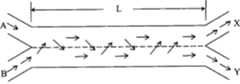
参照图3对以上公式(1-4)和公式(1-5)中的参数说明如下:With reference to Fig. 3, the parameter description in above formula (1-4) and formula (1-5) is as follows:
记AX车道为编号1车道,BY车道编号为2车道;Record the AX lane as the number 1 lane, and the BY lane as the number 2 lane;
记Q1为1车道流量,r1为1车道上交织车辆占Q1的比例,

(C-2)根据上述采集到的数据分别标定经验模型和仿真模型,建立预测模型;包括:(C-2) Calibrate the empirical model and the simulation model respectively according to the data collected above, and establish a prediction model; including:
(1)根据上述采集到的数据对经验模型进行标定和修正,从而建立下列各区域的预测模型;(1) Calibrate and correct the empirical model according to the data collected above, so as to establish the prediction models for the following areas;
(2)根据上述采集到的数据进行交通仿真模型的标定。(2) Calibrate the traffic simulation model based on the data collected above.
其中:各区域预测模型如下:Among them: the prediction models of each region are as follows:
互通立交分流区密度预测模型:Density prediction model for interchange diversion area:
KR=0.484+0.00013QR+0.011Q12-0.0183LD (2-1)KR =0.484+0.00013QR +0.011Q12 -0.0183LD (2-1)
互通立交分流区速度预测模型:Velocity prediction model for interchange diversion area:
VR=VFF-(VFF-50)(1.15+0.0002QR-0.008VFR) (2-2)VR =VFF -(VFF -50)(1.15+0.0002QR -0.008VFR ) (2-2)
互通立交合流区密度预测模型:Density prediction model for the interchange merge area:
KR=1.1+0.0059QR+0.0074Q12-0.01278LA (2-3)KR =1.1+0.0059QR +0.0074Q12 -0.01278LA (2-3)
互通立交合流区速度预测模型:The speed prediction model of the interchange merge area:
互通立交交织区交织速度预测模型:Prediction model of weaving speed in interchange weaving area:
互通立交交织区非交织速度预测模型:Prediction model of non-weaving speed in interchange weaving area:
上述公式(2-1)至公式(2-6)中:From above formula (2-1) to formula (2-6):
KR——分流区与合流区密度,pcu/km/lnKR ——density of diversion area and confluence area, pcu/km/ln
Q——交织区总流量,pcu/hQ——total flow in weaving area, pcu/h
QR——匝道流量,pcu/hQR ——Ramp flow, pcu/h
Q12——主线外侧两车道流量,pcu/hQ12 ——The flow rate of the two lanes outside the main line, pcu/h
L——交织区长度,mL——the length of the weaving area, m
LA——加速车道长度,mLA ——the length of the acceleration lane, m
LD——减速车道长度,mLD —— length of deceleration lane, m
VR——分流区与合流区速度,km/hVR ——Velocity of diversion zone and confluence zone, km/h
VFF——主线自由流速度,km/hVFF ——mainline free flow speed, km/h
VFR——匝道自由流速度,km/hVFR —— ramp free flow speed, km/h
VW——非交织速度,km/hVW ——Non-weaving speed, km/h
N——交织区车道数;N - the number of lanes in the weaving area;
(D)利用评价分析模块分别判断上述预测模型及标定的交通仿真模型与实际交通状况的交通流特性相比较,即:以上计算结果通过实测数据验证,模型计算结果与实测数据的差值均在可接受的范围内,其两者的误差应≤10%;若两者的误差超过10%,则返回上述步骤(C-2),重新标定经验模型和仿真模型;若两者的误差≤10%,则上述标定后的模型可应用于该城市快速路互通立交区的速度和密度预测;(D) Use the evaluation and analysis module to judge the comparison between the above prediction model and the calibrated traffic simulation model and the traffic flow characteristics of the actual traffic conditions, that is, the above calculation results are verified by the measured data, and the difference between the model calculation results and the measured data is within Within the acceptable range, the error of the two should be ≤10%; if the error of the two exceeds 10%, return to the above step (C-2), and recalibrate the empirical model and the simulation model; if the error of the two is ≤10% %, the above calibrated model can be applied to the speed and density prediction of the expressway interchange area in this city;
(E)根据上述结果确定通行能力和服务水平,通过数据输出模块输出下列指标:确定基本路段、分流区、合流区、交织区和各类型匝道的通行能力。(E) Determine traffic capacity and service level based on the above results, and output the following indicators through the data output module: determine the traffic capacity of basic road sections, diversion areas, merge areas, weaving areas and various types of ramps.
实施例一:Embodiment one:
利用本发明设计系统建立的设计模型通过对天津互通立交典型区内通行能力理论分析与对仿真模型的标定和修正,得出针对天津快速路基本路段,互通立交分/合流区、交织区、各类典型匝道和互通立交整体的通行能力值,可以作为天津互通立交选型、方案确定的决策支持,有关互通立交形式的通行能力推荐值见表1至表5。Utilize the design model that the design system of the present invention establishes, through the theoretical analysis of the traffic capacity in the typical area of the Tianjin Interchange and the calibration and correction of the simulation model, it is obtained that for the basic sections of the Tianjin Expressway, the Interchange diverge/merge area, the weaving area, each The overall capacity values of similar typical ramps and interchanges can be used as decision support for the type selection and scheme determination of Tianjin interchanges. The recommended capacity values for interchange forms are shown in Tables 1 to 5.
表1快速路基本路段通行能力推荐表Table 1 Recommended capacity of basic section of expressway
表2互通立交分/合流影响区理论通行能力推荐表 Table 2 Recommendation table for theoretical traffic capacity of interchange divergence/merge influence areas

表3互通立交五车道交织区通行能力推荐表 Table 3 Recommendation table for the traffic capacity of the five-lane weaving area of the interchange
表4各类型匝道通行能力推荐表Table 4 Recommended capacity of various types of ramps

表5互通立交整体通行能力推荐表Table 5 Recommended table for overall traffic capacity of interchange

由城市快速路互通立交各组成部分的交通流统计模型,并结合服务质量衡量指标与服务水平的判定方法,本发明可以确定快速路基本路段、互通立交分/合流区和交织区在标准条件下的服务水平分级统一标准,从而充实、完善现行标准规范体系,通过本发明设计模型所确定的服务水平划分标准见表6。By the traffic flow statistical model of each component of the urban expressway interchange, combined with the service quality measurement index and the judgment method of the service level, the present invention can determine the basic section of the expressway, the interchange diverging/merging area and the weaving area under standard conditions Service level grading unified standard, thereby enriching and perfecting the current standard specification system, the service level division standard determined by the design model of the present invention is shown in Table 6.
表6基本路段、互通立交分/合流区和交织区服务水平划分标准 Table 6 Standards for Classification of Service Levels of Basic Road Sections, Interchange Divide/Merge Areas and Weaving Areas

综上所述,利用本发明设计系统通过对城市快速路典型互通立交区观测,收集到了快速路基本路段,互通立交分/合流区、交织区和各种匝道的交通流特征参数;建立相应的数据库及通行能力理论分析模型;对确定服务水平的速度和密度经验模型加以标定和修正;建立适合该城市快速路互通立交交通流特性的通行能力分析模型。并以该模型指导城市快速路互通立交选型的设计。In summary, utilize the design system of the present invention to collect the expressway basic road section, the traffic flow characteristic parameter of interchange branch/merge area, weaving area and various ramps by observing the typical interchange areas of urban expressways; Database and theoretical analysis model of traffic capacity; Calibrate and correct the empirical model of speed and density for determining the service level; Establish a traffic capacity analysis model suitable for the traffic flow characteristics of the urban expressway interchange. And use this model to guide the design of urban expressway interchange type selection.
实施例二:Embodiment two:
利用上述设计系统得出的所对应的通行能力和服务水平,指导互通立交选型的方法包括以下步骤:Using the corresponding traffic capacity and service level obtained from the above design system, the method to guide the selection of interchanges includes the following steps:
(1)根据现状交通量或预测交通量,对拟建设区交通量进行转向流量主次分析;(1) According to the current traffic volume or forecasted traffic volume, conduct a primary and secondary analysis of the traffic volume in the proposed construction area;
(2)根据通过仿真模型得到基本路段、分流区、合流区、交织区和各类型匝道的通行能力,初步确定互通立交的形式,该互通立交形式是下述几种形式之一或下述几种形式的任意组合:(2) According to the traffic capacity of the basic road section, diverging area, merging area, weaving area and various types of ramps obtained through the simulation model, the form of the interchange is initially determined. The form of the interchange is one of the following forms or the following forms: Any combination of these forms:
苜蓿叶、组合型I和组合型II;Clover Leaf, Combination I and Combination II;
所述组合型I为半定向和定向匝道的组合;所述组合型II为定向匝道组合;The combined type I is a combination of semi-directional and directional ramps; the combined type II is a combination of directional ramps;
(3)利用下列公式得出上述所确定的互通立交形式的立交通行能力数据:(3) Use the following formula to obtain the interchange traffic capacity data of the above-mentioned determined interchange forms:
——当某方向的第一分流影响区与直行车道通行能力之和小于下游分流区与直行车道通行能力之和或交织区通行能力时,互通立交i方向的通行能力为第一分流区与直行车道通行能力之和,即:——When the sum of the traffic capacity of the first diversion area and the through lane in a certain direction is less than the sum of the traffic capacity of the downstream diversion area and the through lane or the traffic capacity of the weaving area, the traffic capacity of the interchange i direction is the first diversion area and the through lane The sum of lane capacities, namely:

——当下游有分流区时,若此方向的第一分流区与直行车道通行能力之和大于下游第二分流区与直行车道通行能力之和,互通立交i方向的通行能力为第二分流区通行能力、直行车道通行能力之和:——When there is a diversion area downstream, if the sum of the capacity of the first diversion area and the through lane in this direction is greater than the sum of the second diversion area downstream and the capacity of the through lane, the traffic capacity of the interchange i direction is the second diversion area The sum of the traffic capacity and the traffic capacity of the through lane:

——当下游有交织区时,若此方向的第一分流影响区与直行车道通行能力之和大于下游进入交织区的主线通行能力之和,互通立交i方向的通行能力为进入交织区的主线通行能力:——When there is a weaving area downstream, if the sum of the traffic capacity of the first diversion area in this direction and the through lane traffic capacity is greater than the sum of the traffic capacity of the main line entering the weaving area downstream, the traffic capacity in the direction i of the interchange is the main line entering the weaving area Capacity:
Ci=C交织-ΔC匝道 (3-3)Ci =Cweaving -ΔCramp (3-3)
——最终分别得出每种互通立交形式整体的通行能力:—— Finally, the overall traffic capacity of each interchange form is obtained separately:
上述公式(3-1)至公式(3-4)中,Ci为互通立交i方向的通行能力,单位为pcu/h;C分1、C分2、C交织分为i方向两个分流区和交织区的通行能力,单位为pcu/h;C直i为第i直行车道最大通过量,当分流区外侧仅有一条直行车道时,考虑距离效应,其最大通过量按照第二直行车道取值,单位为pcu/h;ΔC匝道为各交织流量比条件下的进口匝道流量,单位为pcu/h;In the above formula (3-1) to formula (3-4), Ci is the traffic capacity of the interchange in the direction i, and theunit is pcu/h; The traffic capacity of the area and the weaving area, the unit is pcu/h; C-i is the maximum throughput of the i-th through lane, when there is only one through lane outside the diversion area, considering the distance effect, the maximum throughput of the second through lane Value, the unit is pcu/h; ΔCramp is the flow rate of the entrance ramp under the conditions of each weaving flow ratio, the unit is pcu/h;
(4)根据拟建设区远景预测交通量,与上述各种互通立交形式的通行能力分别进行比较,判断是否匹配,从而确定该拟建设区的互通立交设计方案。(4) According to the forecasted traffic volume of the proposed construction area, compare it with the capacity of the above-mentioned various interchange forms to determine whether they match, so as to determine the interchange design scheme of the proposed construction area.
所述初步确定互通立交形式时,包括下述情形:The preliminary determination of the form of the interchange includes the following situations:
(1)匝道形式的选择:立交选型时应依据预测交通量对各个转向交通进行分析,并结合城市周边地形及关键控制点布设立交。左转匝道形式的选择决定了立交的形式,应根据匝道预测交通量的大小和服务水平的高低,依次选用定向匝道、半定向匝道和环形匝道,同时匝道的平纵线形指标应与交通量相适应,交通量大、大车混入率高的匝道应具有较高的平纵线形指标。(1) Selection of the ramp form: when selecting the interchange type, it is necessary to analyze each turning traffic based on the predicted traffic volume, and to arrange the interchange in consideration of the terrain around the city and key control points. The choice of the form of the left-turn ramp determines the form of the interchange. According to the predicted traffic volume and service level of the ramp, directional ramp, semi-directional ramp and circular ramp should be selected in sequence. To adapt, ramps with large traffic volume and high mixing rate of large vehicles should have higher horizontal and vertical alignment indicators.
(2)交织区的选用:在立交选型时应尽量减少交织区。设计时,可根据交通需求对全苜蓿叶型立交进行灵活的变化,将环形匝道呈对角形式布置在两个象限内,另外的象限按照交通量由大到小的次序,宜采用定向和半定向匝道。(2) Selection of weaving area: The weaving area should be minimized when selecting the type of interchange. During the design, the full cloverleaf interchange can be flexibly changed according to the traffic demand, and the circular ramps are arranged in two quadrants in a diagonal form. The other quadrants should adopt directional and semi Orientation ramp.
如受地形限制必须布设交织区时,应保证交织区交织流量比不高于0.2。若将交织区与主线采用硬分隔,应保证转向交通量和交织流量比均较小,同时注重与快速路连接部的处理,采用单一进出口,通过分/合流的形式进出主线,提高该路段的主线通行能力。If the weaving area must be arranged due to terrain restrictions, the weaving flow ratio of the weaving area shall not be higher than 0.2. If the weaving area is hard separated from the main line, it should be ensured that the turning traffic volume and the weaving flow ratio are relatively small, and at the same time pay attention to the treatment of the connection with the expressway, adopt a single entrance and exit, enter and exit the main line in the form of diversion/merge, and improve the road section. mainline traffic capacity.
所述初步确定互通立交形式时,匝道设计指标如下:When the form of the interchange is initially determined, the ramp design indicators are as follows:
(1)左转(半)定向匝道:考虑允许超车,防止部分低速车辆在匝道上压车对匝道的通行能力产生影响,对于长距离、大纵坡、高标高的匝道应设置成双车道。设置条件为长度超过300m的(半)定向匝道,交通量大于600pcu/h,且大中型车混入率不低于20%。同时考虑安全问题,匝道汇流处划线设置为单车道入口。(1) Left-turn (half) directional ramps: consider allowing overtaking to prevent some low-speed vehicles from being crushed on the ramp and affect the capacity of the ramp. For ramps with long distances, large longitudinal slopes, and high elevations, double lanes should be set up. The setting conditions are (semi) directional ramps with a length of more than 300m, a traffic volume greater than 600pcu/h, and a mixed rate of large and medium-sized vehicles not less than 20%. Considering safety issues at the same time, the line at the ramp confluence is set as a single-lane entrance.
(2)环形匝道:环形匝道的布设对立交的占地影响较大,应在满足车辆安全高效通行的前提下减少立交对城市用地的影响,因此建议环形匝道平曲线半径取低值,R=50m,环形匝道设计车速取40km/h。(2) Circular ramp: The layout of the circular ramp has a greater impact on the land occupation of the interchange. The impact of the interchange on urban land should be reduced under the premise of meeting the safe and efficient passage of vehicles. Therefore, it is recommended to take a low value for the radius of the horizontal curve of the circular ramp, R = 50m, the design speed of the circular ramp is 40km/h.
(3)右转匝道:S型右转匝道速度高于设计速度,同时和标准型右转匝道相比,其通行能力相差不多,在用地限制时推荐采用。(3) Right-turn ramp: The speed of the S-type right-turn ramp is higher than the design speed, and compared with the standard right-turn ramp, its traffic capacity is similar, and it is recommended to be used when the land use is limited.
(4)匝道合流:两条匝道汇流成一条匝道时,车道减少导致车辆抢道行驶,易造成匝道拥堵。建议匝道合流后车道数不变,同时注重下游匝道与主线连接处的处理,保证车道平衡。(4) Ramp merge: When two ramps merge into one ramp, the reduction of lanes will cause vehicles to rush to drive, which will easily cause ramp congestion. It is recommended that the number of lanes remain unchanged after the ramp merges, and attention should be paid to the treatment of the connection between the downstream ramp and the main line to ensure lane balance.
实施例三:一城市快速路互通立交选型设计Embodiment 3: Type selection design of an urban expressway interchange
根据现状交通量或预测交通量,对拟建设区内两条双向8车道城市快速路相交处交通量进行转向流量主次分析:拟建立互通立交的该处路口2026年规划预测远景交通量所图4所示。According to the current traffic volume or predicted traffic volume, the primary and secondary analysis of the traffic volume at the intersection of two two-way 8-lane urban expressways in the proposed construction area is carried out: the 2026 planning and forecast traffic volume at the intersection where the interchange is planned to be established 4.
根据通过仿真模型得到基本路段、分流区、合流区、交织区和各类型匝道的通行能力,初步确定互通立交的形式,该互通立交形式有下述几种方案备选:According to the traffic capacity of the basic road section, diversion area, merge area, weaving area and various types of ramps obtained through the simulation model, the form of the interchange is preliminarily determined. The form of the interchange has the following options:
方案一:组合型I,如图5-1所示,该方案将环形匝道呈对角形式布置在两个象限内,另外的象限按照交通量由大到小的次序,宜采用定向和半定向匝道。立交只有分流和合流区,没有交织区。该方案造价估算为36000万元。Scheme 1: Combined type I, as shown in Figure 5-1, this scheme arranges the circular ramp in two quadrants in a diagonal form, and the other quadrants should adopt directional and semi-directional traffic in order of traffic volume from large to small ramp. Interchanges only have diversion and merge areas, but no weaving areas. The project cost is estimated at 360 million yuan.
方案二:为苜蓿叶型立交,如图5-2所示,该方案中的四个象限均为环形匝道。立交有四处交织区。该方案造价估算为23000万元。Scheme 2: It is a cloverleaf interchange, as shown in Figure 5-2. The four quadrants in this scheme are circular ramps. The interchange has four weaving areas. The project cost is estimated at 230 million yuan.
方案三:为组合型I立交,如图5-3所示,该方案将两个环形匝道布置在一个方向,同时将两个主要流向做成半定向匝道。该方案造价估算为32000万元。Scheme 3: It is a combination type I interchange, as shown in Figure 5-3. In this scheme, two circular ramps are arranged in one direction, and the two main flow directions are made into semi-directional ramps. The project cost is estimated at 320 million yuan.
利用前述的公式(3-1)至公式(3-5)分别计算上述三个初选方案的立交总通行能力:Use the aforementioned formula (3-1) to formula (3-5) to calculate the total traffic capacity of the interchange for the above three primary options:
上述方案一的立交总通行能力为25620pcu/h;上述方案二的立交总通行能力为23905pcu/h;上述方案三的立交总通行能力为30790pcu/h。The total traffic capacity of the overpass of the above-mentioned scheme one is 25620pcu/h; the total traffic capacity of the overpass of the above-mentioned scheme two is 23905pcu/h; the total traffic capacity of the overpass of the above-mentioned scheme three is 30790pcu/h.
按照预测拟建立交处2026年路口总的交通量为17843pcu/h,如图6所示:该处总的交通流量=(B+C+E+H)Pcu/h或(A+D+F+G)Pcu/h;其中:A=M1+M2+M3;B=M4+M5+M9;C=M2+M7+M11;D=M8+M9+M10;E=M1+M6+M10;F=M4+M12+M11;G=M5+M6+M7;H=M3+M8+M12。According to the prediction, the total traffic volume of the intersection in 2026 planned to be established is 17843pcu/h, as shown in Figure 6: the total traffic volume=(B+C+E+H)Pcu/h or (A+D+F +G)Pcu/h; where: A=M1+M2+M3; B=M4+M5+M9; C=M2+M7+M11; D=M8+M9+M10; E=M1+M6+M10; F =M4+M12+M11; G=M5+M6+M7; H=M3+M8+M12.
根据该预测交通量,与上述各种互通立交形式的通行能力分别进行比较,判断是否匹配,从而确定一套切实可行的互通立交的设计方案。经验算,三个方案立交总交通量均大于拟建立交处2026年路口预测交通量。其中,方案二最为接近。考虑预测交通量的变化性,将预测拟建立交处的交通总量上浮20%后为21412pcu/h,该值小于方案二立交总通行能力23905pcu/h,而且方案二中立交各部分均可满足转向交通的需求。因此将方案二作为该处路口的推荐方案。另外,方案二造价分别较方案一减少13000万元,较方案三减少9000万元。因此,认为方案二为相对较理想的选型设计方案。According to the predicted traffic volume, it is compared with the traffic capacity of the above-mentioned various forms of interchanges to determine whether they match, so as to determine a set of feasible design schemes for interchanges. According to empirical calculations, the total traffic volume of the interchanges in the three schemes is greater than the predicted traffic volume of the proposed intersection in 2026. Among them, option 2 is the closest. Considering the variability of the forecasted traffic volume, the total traffic volume of the proposed interchange will be 21412pcu/h after a 20% increase, which is less than the total capacity of the interchange in Scheme 2, which is 23905pcu/h, and all parts of the interchange in Scheme 2 can meet the requirements Turn to traffic needs. Therefore, plan 2 is taken as the recommended plan for this intersection. In addition, the cost of Scheme 2 is 130 million yuan less than that of Scheme 1, and 90 million yuan less than that of Scheme 3. Therefore, the second option is considered to be a relatively ideal selection design.
利用本发明设计系统,根据互通立交区现场观测数据,已对天津市快速路互通立交进行了仿真模型参数标定。其标定内容包括车辆分车道分车型期望速度、合流区加速车道车辆换车道模型、交织区集散车道车辆换车道模型、典型车辆加减速特性等。经过实测值与仿真值的误差分析结果显示,仿真模型不仅具有很好的稳定性,而且与实际的交通流状态吻合较好,完全可以作为互通立交区的交通分析平台,直接用于天津市快速路系统的交通分析。交通流仿真实验平台的建立,可对拟建互通立交的服务水平进行分析,直观再现未来的交通运行状况,以发现潜在的设计缺陷,便于针对问题提出改进措施。这对于节约公路建设投资、提高设施使用效能和挖掘现有交通设施的潜力,无疑具有十分重要的现实意义。当然,在本发明的基础上经过调整修正系数,可以广泛应用于城市快速路的设计中。Utilizing the design system of the present invention, according to the on-site observation data of the interchange area, the simulation model parameter calibration has been carried out for the expressway interchange in Tianjin. The calibration content includes the expected speed of vehicles divided into lanes and models, the vehicle lane change model of the acceleration lane in the merge area, the vehicle lane change model of the collection and distribution lane in the weaving area, and the acceleration and deceleration characteristics of typical vehicles. The error analysis results of the measured value and the simulated value show that the simulation model not only has good stability, but also agrees well with the actual traffic flow state. It can be used as a traffic analysis platform in the interchange area and directly used in Tianjin Expressway Traffic analysis of road systems. The establishment of the traffic flow simulation experiment platform can analyze the service level of the proposed interchange, visually reproduce the future traffic operation status, find potential design defects, and propose improvement measures for the problems. This is undoubtedly of great practical significance for saving investment in road construction, improving the efficiency of facilities, and tapping the potential of existing transportation facilities. Certainly, after adjusting the correction coefficient on the basis of the present invention, it can be widely used in the design of urban expressways.
另外,值得关注的是:大车的速度主要受纵坡影响,而且大车运行将对其他车辆造成延误。因此在立交设计中应重视对大车混入率的分析,对于大车混入率过高的方向适当提高平纵标准,以提高该处通行能力。还有,互通立交的出口应设置在容易识别处,同一方向的左、右转宜设置统一出口,即立交同一方向的出入口应唯一。如同一方向的左、右转出入口受地形、工程量的影响不能一同出入时,应保证第一出口为右转,第二出口为左转,并设置合理的交通标志及时提示。In addition, it is worth noting that the speed of the cart is mainly affected by the longitudinal slope, and the operation of the cart will cause delays to other vehicles. Therefore, in the design of interchanges, attention should be paid to the analysis of the mixing rate of large vehicles, and the horizontal and vertical standards should be appropriately raised in the direction where the mixing rate of large vehicles is too high, so as to improve the traffic capacity at this place. In addition, the exit of the interchange should be set at an easily identifiable place, and a unified exit should be set up for left and right turns in the same direction, that is, the entrance and exit of the interchange in the same direction should be unique. If the left and right turning entrances in the same direction cannot be entered and exited together due to the influence of terrain and engineering volume, it shall be ensured that the first exit is a right turn and the second exit is a left turn, and reasonable traffic signs shall be set up to remind in time.
尽管结合附图对本发明进行了上述描述,但是本发明并不局限于上述的具体实施方式,上述的具体实施方式仅仅是示意性的,而不是限制性的,本领域的普通技术人员在本发明的启示下,在不脱离本发明宗旨的情况下,还可以做出很多变形,这些均属于本发明的保护之列。Although the present invention has been described above in conjunction with the accompanying drawings, the present invention is not limited to the above-mentioned specific embodiments, and the above-mentioned specific embodiments are only illustrative, rather than restrictive. Under the enlightenment of the present invention, many modifications can be made without departing from the gist of the present invention, and these all belong to the protection of the present invention.
Claims (3)


Priority Applications (1)
| Application Number | Priority Date | Filing Date | Title |
|---|---|---|---|
| CN 200810052478CN101246514B (en) | 2008-03-20 | 2008-03-20 | City fast road intercommunicated overpass simulation design system and method for establishing design model |
Applications Claiming Priority (1)
| Application Number | Priority Date | Filing Date | Title |
|---|---|---|---|
| CN 200810052478CN101246514B (en) | 2008-03-20 | 2008-03-20 | City fast road intercommunicated overpass simulation design system and method for establishing design model |
Publications (2)
| Publication Number | Publication Date |
|---|---|
| CN101246514Atrue CN101246514A (en) | 2008-08-20 |
| CN101246514B CN101246514B (en) | 2012-12-19 |
Family
ID=39946965
Family Applications (1)
| Application Number | Title | Priority Date | Filing Date |
|---|---|---|---|
| CN 200810052478ActiveCN101246514B (en) | 2008-03-20 | 2008-03-20 | City fast road intercommunicated overpass simulation design system and method for establishing design model |
Country Status (1)
| Country | Link |
|---|---|
| CN (1) | CN101246514B (en) |
Cited By (22)
| Publication number | Priority date | Publication date | Assignee | Title |
|---|---|---|---|---|
| CN102156790A (en)* | 2011-04-27 | 2011-08-17 | 天津市市政工程设计研究院 | Method for designing main road multifunctional lane of express way based on delay and traffic capacity |
| CN102163369A (en)* | 2010-02-24 | 2011-08-24 | 交通运输部公路科学研究所 | Road running speed acquisition system |
| CN102314771A (en)* | 2011-04-27 | 2012-01-11 | 天津市市政工程设计研究院 | Method for determining minimum distance of fast road exit/entrance based on smoothness analysis |
| CN103456163A (en)* | 2012-06-04 | 2013-12-18 | 北京市市政工程设计研究总院 | City expressway interchange traffic capacity and running status discrimination method and system |
| CN103617736A (en)* | 2013-12-17 | 2014-03-05 | 南宁光波科技有限公司 | Road monitoring device |
| CN103871241A (en)* | 2014-03-19 | 2014-06-18 | 同济大学 | Lane dynamic partitioning control method for expressway intersection area |
| CN104952252A (en)* | 2015-06-19 | 2015-09-30 | 辽宁省交通规划设计院 | Method and system for acquiring traffic capacity of main-auxiliary separation type multi-lane highway |
| CN106023602A (en)* | 2016-06-15 | 2016-10-12 | 重庆交通大学 | Mountainous city signal intersection delay calculation method |
| WO2017041524A1 (en)* | 2015-09-11 | 2017-03-16 | 杭州海康威视数字技术股份有限公司 | Method and device for processing traffic road information |
| CN106780272A (en)* | 2016-12-05 | 2017-05-31 | 南通大学 | A kind of method that utilization traffic conflict calculates diamond interchange deceleration ring road length |
| CN106935033A (en)* | 2017-04-28 | 2017-07-07 | 青岛科技大学 | The ofaiterative, dynamic linearisation of Expressway Traffic system and Learning Control Method |
| CN106991815A (en)* | 2017-05-23 | 2017-07-28 | 招商局重庆交通科研设计院有限公司 | Traffic congestion control method |
| CN107562983A (en)* | 2017-07-17 | 2018-01-09 | 北京工业大学 | A kind of city expressway ring road region lane-change space optimization method and device |
| CN108615377A (en)* | 2018-05-28 | 2018-10-02 | 安徽畅通行交通信息服务有限公司 | A kind of traffic passage matching evaluation method based on bayonet data |
| CN110164129A (en)* | 2019-04-25 | 2019-08-23 | 浙江工业大学 | Single Intersection multi-lane traffic flow amount prediction technique based on GERNN |
| CN111118989A (en)* | 2019-12-31 | 2020-05-08 | 长安大学 | Method for standardizing A-type single-horn intercommunication design of highway |
| CN112224211A (en)* | 2020-10-19 | 2021-01-15 | 中交第一公路勘察设计研究院有限公司 | Driving simulation system based on multi-autonomous-body traffic flow |
| CN112419708A (en)* | 2020-08-17 | 2021-02-26 | 腾讯科技(深圳)有限公司 | Road safety strategy determination method and device based on traffic flow aggressiveness degree |
| CN113094875A (en)* | 2021-03-16 | 2021-07-09 | 东南大学 | Method and device for calibrating micro traffic simulation system in urban expressway intersection area |
| CN113327421A (en)* | 2021-06-04 | 2021-08-31 | 河北省交通规划设计院 | Road network control method and system based on V2X |
| CN113450563A (en)* | 2021-05-18 | 2021-09-28 | 贵阳锐鑫机械加工有限公司 | Analysis model based on multi-turn road traffic jam reasons and anti-blocking method |
| CN113918869A (en)* | 2021-09-02 | 2022-01-11 | 昆明理工大学 | Method for calculating traffic capacity of right-turn vehicle in advance for non-forced priority mixed transportation travel |
Family Cites Families (3)
| Publication number | Priority date | Publication date | Assignee | Title |
|---|---|---|---|---|
| CN1380465A (en)* | 2002-04-27 | 2002-11-20 | 姚青 | Supergrade plane intercross installation for road and its traffic method |
| CN101050616A (en)* | 2007-02-06 | 2007-10-10 | 张耀胜 | Optimum plan for city traffic and planning |
| CN101246513A (en)* | 2008-03-20 | 2008-08-20 | 天津市市政工程设计研究院 | Simulation Design System and Type Selection Method of Urban Expressway Interchange |
- 2008
- 2008-03-20CNCN 200810052478patent/CN101246514B/enactiveActive
Cited By (31)
| Publication number | Priority date | Publication date | Assignee | Title |
|---|---|---|---|---|
| CN102163369A (en)* | 2010-02-24 | 2011-08-24 | 交通运输部公路科学研究所 | Road running speed acquisition system |
| CN102156790A (en)* | 2011-04-27 | 2011-08-17 | 天津市市政工程设计研究院 | Method for designing main road multifunctional lane of express way based on delay and traffic capacity |
| CN102314771A (en)* | 2011-04-27 | 2012-01-11 | 天津市市政工程设计研究院 | Method for determining minimum distance of fast road exit/entrance based on smoothness analysis |
| CN103456163A (en)* | 2012-06-04 | 2013-12-18 | 北京市市政工程设计研究总院 | City expressway interchange traffic capacity and running status discrimination method and system |
| CN103617736B (en)* | 2013-12-17 | 2016-04-13 | 南宁光波科技有限公司 | A kind of road monitoring device |
| CN103617736A (en)* | 2013-12-17 | 2014-03-05 | 南宁光波科技有限公司 | Road monitoring device |
| CN103871241A (en)* | 2014-03-19 | 2014-06-18 | 同济大学 | Lane dynamic partitioning control method for expressway intersection area |
| CN103871241B (en)* | 2014-03-19 | 2016-04-06 | 同济大学 | One dynamically divides control method towards track, Weaving Sections of Urban Expressway |
| CN104952252A (en)* | 2015-06-19 | 2015-09-30 | 辽宁省交通规划设计院 | Method and system for acquiring traffic capacity of main-auxiliary separation type multi-lane highway |
| CN104952252B (en)* | 2015-06-19 | 2016-06-01 | 辽宁省交通规划设计院 | Obtain method and the system of the Separation of main work and non-main work formula multilane motorway traffic capacity |
| WO2017041524A1 (en)* | 2015-09-11 | 2017-03-16 | 杭州海康威视数字技术股份有限公司 | Method and device for processing traffic road information |
| CN106023602B (en)* | 2016-06-15 | 2018-03-30 | 重庆交通大学 | Mountainous City signalized intersections delay estimation method |
| CN106023602A (en)* | 2016-06-15 | 2016-10-12 | 重庆交通大学 | Mountainous city signal intersection delay calculation method |
| CN106780272A (en)* | 2016-12-05 | 2017-05-31 | 南通大学 | A kind of method that utilization traffic conflict calculates diamond interchange deceleration ring road length |
| CN106780272B (en)* | 2016-12-05 | 2020-10-30 | 南通大学 | A method for calculating the length of a diamond-shaped interchange deceleration ramp by using traffic conflicts |
| CN106935033A (en)* | 2017-04-28 | 2017-07-07 | 青岛科技大学 | The ofaiterative, dynamic linearisation of Expressway Traffic system and Learning Control Method |
| CN106991815A (en)* | 2017-05-23 | 2017-07-28 | 招商局重庆交通科研设计院有限公司 | Traffic congestion control method |
| CN107562983A (en)* | 2017-07-17 | 2018-01-09 | 北京工业大学 | A kind of city expressway ring road region lane-change space optimization method and device |
| CN107562983B (en)* | 2017-07-17 | 2021-01-01 | 北京工业大学 | Urban expressway ramp area lane change space optimization method and device |
| CN108615377A (en)* | 2018-05-28 | 2018-10-02 | 安徽畅通行交通信息服务有限公司 | A kind of traffic passage matching evaluation method based on bayonet data |
| CN110164129A (en)* | 2019-04-25 | 2019-08-23 | 浙江工业大学 | Single Intersection multi-lane traffic flow amount prediction technique based on GERNN |
| CN111118989A (en)* | 2019-12-31 | 2020-05-08 | 长安大学 | Method for standardizing A-type single-horn intercommunication design of highway |
| CN112419708A (en)* | 2020-08-17 | 2021-02-26 | 腾讯科技(深圳)有限公司 | Road safety strategy determination method and device based on traffic flow aggressiveness degree |
| CN112419708B (en)* | 2020-08-17 | 2022-03-29 | 腾讯科技(深圳)有限公司 | Road safety strategy determination method and device based on traffic flow aggressiveness degree |
| CN112224211A (en)* | 2020-10-19 | 2021-01-15 | 中交第一公路勘察设计研究院有限公司 | Driving simulation system based on multi-autonomous-body traffic flow |
| CN113094875A (en)* | 2021-03-16 | 2021-07-09 | 东南大学 | Method and device for calibrating micro traffic simulation system in urban expressway intersection area |
| CN113094875B (en)* | 2021-03-16 | 2024-04-09 | 东南大学 | A method and device for calibrating a microscopic traffic simulation system in an urban expressway weaving area |
| CN113450563A (en)* | 2021-05-18 | 2021-09-28 | 贵阳锐鑫机械加工有限公司 | Analysis model based on multi-turn road traffic jam reasons and anti-blocking method |
| CN113327421A (en)* | 2021-06-04 | 2021-08-31 | 河北省交通规划设计院 | Road network control method and system based on V2X |
| CN113918869A (en)* | 2021-09-02 | 2022-01-11 | 昆明理工大学 | Method for calculating traffic capacity of right-turn vehicle in advance for non-forced priority mixed transportation travel |
| CN113918869B (en)* | 2021-09-02 | 2024-04-02 | 昆明理工大学 | Advanced right-turn vehicle traffic capacity calculation method for non-forced priority mixed traffic travel |
Also Published As
| Publication number | Publication date |
|---|---|
| CN101246514B (en) | 2012-12-19 |
Similar Documents
| Publication | Publication Date | Title |
|---|---|---|
| CN101246514B (en) | City fast road intercommunicated overpass simulation design system and method for establishing design model | |
| CN101246513A (en) | Simulation Design System and Type Selection Method of Urban Expressway Interchange | |
| Yang et al. | Eco-driving system for connected automated vehicles: Multi-objective trajectory optimization | |
| Zhu et al. | Do high-speed railways accelerate urban land expansion in China? A study based on the multi-stage difference-in-differences model | |
| Cervero | Induced travel demand: Research design, empirical evidence, and normative policies | |
| CN101383091B (en) | Network control system for traffic induction outdoor screen | |
| CN102201021B (en) | Expressway aided design system | |
| CN105894814B (en) | Consider a variety of traffic control measure combined optimization methods and system of environmental benefit | |
| CN108447256A (en) | Trunk road vehicle trajectory reconstruction method based on electric police and fixed point detector data fusion | |
| CN103456163A (en) | City expressway interchange traffic capacity and running status discrimination method and system | |
| CN110992699A (en) | Urban road network public traffic right road network planning method | |
| Pan et al. | Evaluating designs of a three-lane exit ramp based on the entropy method | |
| k Alobaidi et al. | Evaluating the negative impact of traffic congestion on air pollution at signalized intersection | |
| Li et al. | Planning and Layout Method for Community Bus Stops Based on Carbon Reduction Benefits | |
| Maduranga et al. | Selection of optimum junction operation strategy for gatambe intersection using VISSIM simulation | |
| CN114708733A (en) | Intelligent city traffic safety management decision support system | |
| Wang et al. | Motor vehicle emission modeling and software simulation computing for roundabout in urban city | |
| CN102609625B (en) | A kind of outskirts of a town expressway entrance and exit ring road bit selecting method | |
| Sakkas | Simulation and analysis of the performance of a traffic network in Zurich | |
| Sharma et al. | Performance enhancement and congestion reduction at busy signalized at-grade intersection with Bus Rapid Transit corridor and mixed traffic in India | |
| CN116311973B (en) | A tram intersection control strategy optimization method | |
| Cai et al. | Length of Collecting and Distributing Lane of Alfalfa Leaf Interchange Study | |
| CN102842233B (en) | Based on the FPGA on-line prediction control method of K ü hne macroscopic traffic flow | |
| CN116108636A (en) | Tourist tramcar intersection traffic organization optimization method based on VISSIM simulation | |
| Sun et al. | Traffic Investigation and Control of Hefei Economic Development Zone |
Legal Events
| Date | Code | Title | Description |
|---|---|---|---|
| C06 | Publication | ||
| PB01 | Publication | ||
| C10 | Entry into substantive examination | ||
| SE01 | Entry into force of request for substantive examination | ||
| C14 | Grant of patent or utility model | ||
| GR01 | Patent grant | ||
| CP01 | Change in the name or title of a patent holder | ||
| CP01 | Change in the name or title of a patent holder | Address after:300051 No. 239, Yingkou Road, Heping District, Tianjin Patentee after:Tianjin municipal engineering design and Research Institute Co.,Ltd. Address before:300051 No. 239, Yingkou Road, Heping District, Tianjin Patentee before:TIANJIN MUNICIPAL ENGINEERING DESIGN & Research Institute |