CN100407235C - Method for inferring a set of characteristics of an environment using a device with location capabilities - Google Patents
Method for inferring a set of characteristics of an environment using a device with location capabilitiesDownload PDFInfo
- Publication number
- CN100407235C CN100407235CCN038006685ACN03800668ACN100407235CCN 100407235 CCN100407235 CCN 100407235CCN 038006685 ACN038006685 ACN 038006685ACN 03800668 ACN03800668 ACN 03800668ACN 100407235 CCN100407235 CCN 100407235C
- Authority
- CN
- China
- Prior art keywords
- environment
- equipment
- path
- time
- location
- Prior art date
- Legal status (The legal status is an assumption and is not a legal conclusion. Google has not performed a legal analysis and makes no representation as to the accuracy of the status listed.)
- Expired - Fee Related
Links
Images

Classifications
- G—PHYSICS
- G08—SIGNALLING
- G08B—SIGNALLING OR CALLING SYSTEMS; ORDER TELEGRAPHS; ALARM SYSTEMS
- G08B21/00—Alarms responsive to a single specified undesired or abnormal condition and not otherwise provided for
- G08B21/02—Alarms for ensuring the safety of persons
- G08B21/0202—Child monitoring systems using a transmitter-receiver system carried by the parent and the child
- G08B21/0205—Specific application combined with child monitoring using a transmitter-receiver system
- G08B21/0211—Combination with medical sensor, e.g. for measuring heart rate, temperature
- G—PHYSICS
- G07—CHECKING-DEVICES
- G07C—TIME OR ATTENDANCE REGISTERS; REGISTERING OR INDICATING THE WORKING OF MACHINES; GENERATING RANDOM NUMBERS; VOTING OR LOTTERY APPARATUS; ARRANGEMENTS, SYSTEMS OR APPARATUS FOR CHECKING NOT PROVIDED FOR ELSEWHERE
- G07C1/00—Registering, indicating or recording the time of events or elapsed time, e.g. time-recorders for work people
- G07C1/20—Checking timed patrols, e.g. of watchman
- G—PHYSICS
- G07—CHECKING-DEVICES
- G07C—TIME OR ATTENDANCE REGISTERS; REGISTERING OR INDICATING THE WORKING OF MACHINES; GENERATING RANDOM NUMBERS; VOTING OR LOTTERY APPARATUS; ARRANGEMENTS, SYSTEMS OR APPARATUS FOR CHECKING NOT PROVIDED FOR ELSEWHERE
- G07C9/00—Individual registration on entry or exit
- G07C9/20—Individual registration on entry or exit involving the use of a pass
- G07C9/28—Individual registration on entry or exit involving the use of a pass the pass enabling tracking or indicating presence
- G—PHYSICS
- G08—SIGNALLING
- G08B—SIGNALLING OR CALLING SYSTEMS; ORDER TELEGRAPHS; ALARM SYSTEMS
- G08B21/00—Alarms responsive to a single specified undesired or abnormal condition and not otherwise provided for
- G08B21/02—Alarms for ensuring the safety of persons
- G08B21/0202—Child monitoring systems using a transmitter-receiver system carried by the parent and the child
- G08B21/0227—System arrangements with a plurality of child units
- G—PHYSICS
- G08—SIGNALLING
- G08B—SIGNALLING OR CALLING SYSTEMS; ORDER TELEGRAPHS; ALARM SYSTEMS
- G08B21/00—Alarms responsive to a single specified undesired or abnormal condition and not otherwise provided for
- G08B21/02—Alarms for ensuring the safety of persons
- G08B21/0202—Child monitoring systems using a transmitter-receiver system carried by the parent and the child
- G08B21/0294—Display details on parent unit
Landscapes
- Health & Medical Sciences (AREA)
- General Health & Medical Sciences (AREA)
- Physics & Mathematics (AREA)
- General Physics & Mathematics (AREA)
- Child & Adolescent Psychology (AREA)
- Business, Economics & Management (AREA)
- Emergency Management (AREA)
- Cardiology (AREA)
- Heart & Thoracic Surgery (AREA)
- Alarm Systems (AREA)
Abstract
Description
Translated fromChinese相关发明参考Related Invention References
本发明涉及由Perkins等人于2002年5月14日申请的、名为“System and Method for Inferring an Electronic Rendering of anEnvironment(用于推测环境的电子透视图的系统和方法)”、申请号为10/145,257的美国专利(代理人受理号:CM01959G),它与本申请一起由摩托罗拉公司所拥有。The present invention relates to the application by Perkins et al. on May 14, 2002, entitled "System and Method for Inferring an Electronic Rendering of an Environment (system and method for inferring the electronic perspective of an environment)", the application number is 10 US Patent No. /145,257 (Attorney Docket No. CM01959G), which is owned by Motorola, Inc. together with this application.
技术领域technical field
本发明一般涉及用于使用具有定位能力的设备来推测环境的一组特征的系统和方法。The present invention generally relates to systems and methods for inferring a set of characteristics of an environment using a location-capable device.
背景技术Background technique
在本领域中公知的定位系统已经达到了很完善的程度,已经可以用它在建筑物和其它有限的区域内实现精确的位置覆盖。扩频和超宽频带(“UWB”)技术极大地改善了计时精度,解决覆盖问题的分布式系统已经出现了,并且能够解决短期稳定性和覆盖漏洞(hole)的便携式惯性制导系统(portable inertial navigation system)(“PINS”)的可投入应用的设备也已经出现了。Positioning systems are known in the art to such an extent that they can be used to achieve precise location coverage within buildings and other limited areas. Spread-spectrum and ultra-wideband ("UWB") technologies have greatly improved timekeeping accuracy, distributed systems have emerged to address coverage issues, and portable inertial guidance systems can address short-term stability and coverage holes navigation system) ("PINS") available devices have also appeared.
关于建筑物中的定位系统的使用例通常都是结合用于定位系统的预安装的基础设施,和可以让定位信息与建筑物或邻近发生事件的地区的布局相互关联的、详细的建筑物规划(planning)一同考虑的。然而,在现实世界中的很多使用例中,这种信息是无法得到的。例如,消防队员、警察和军事人员经常需要在第一次接触时还没有特征化的环境中执行任务。在某些市区正在建立存储建筑物楼层平面图的数据库,但是楼层平面图会经常变动,并且许多事件都是发生在旧的或废弃的建筑中的,对于这些建筑结构来说这些数据是无法获得的。在外国领土上的军事行动通常需要在这些数据未知或被敌方故意隐瞒的环境中执行。Use cases for location systems in buildings are often combined with pre-installed infrastructure for location systems and detailed building plans that allow location information to be correlated with the layout of buildings or nearby areas where events occur (planning) considered together. However, in many real-world use cases, this information is not available. For example, firefighters, police and military personnel are often required to perform tasks in environments that have not been characterized at the time of first contact. Databases storing building floor plans are being established in some urban areas, but floor plans change frequently and many events occur in old or abandoned buildings for which this data is unavailable . Military operations on foreign soil often need to be conducted in environments where these data are unknown or deliberately concealed by the adversary.
由于缺电、浓烟和其它因素可将能见度降低到几英寸,所以这个问题对(诸如救火这样的)紧急行动(emergency operation)的影响特别大。将事件的发展特征化、识别诸如危险物质的风险、预测跳火(flashover)和回程(backdrafi)条件、营救行动和规划逃生路线都可以从有关邻近事件发生的地方的布局和状态的知识中得到很大的帮助。得到诸如楼层平面图的拓扑信息的先验集(priori collection)通常是不切实际的;对环境信息的先验集(诸如阻塞的或不能通行的路径、结构的损坏、环境温度、敌方的出现、危险物质的出现或化学或生化武器的部署)是根本不可能得到的。This problem is particularly problematic for emergency operations (such as firefighting) because lack of power, dense smoke, and other factors can reduce visibility to a few inches. characterizing the development of an event, identifying risks such as hazardous materials, predicting flashover and backdrafi conditions, rescue operations, and planning escape routes can all be derived from knowledge about the layout and status of places adjacent to the event great help. It is usually impractical to obtain a priori collection of topological information such as floor plans; priori collections of environmental information (such as blocked or impassable paths, damage to structures, ambient temperature, presence of enemies) , the presence of hazardous substances or the deployment of chemical or biological weapons) are simply impossible to obtain.
因此,需要一种动态构造指定区域的电子透视图的方法,它可以让用户判断他们在指定的区域中与物体或其他用户的相对位置,以及指定区域的特征/属性。Therefore, there is a need for a method of dynamically constructing an electronic perspective of a designated area, which allows users to judge their relative position to objects or other users in the designated area, as well as the characteristics/attributes of the designated area.
附图说明Description of drawings
现在将参考附图(仅以举例的方式)来描述本发明的优选实施例,在附图中:Preferred embodiments of the invention will now be described, by way of example only, with reference to the accompanying drawings, in which:
图1是图解说明根据本发明、正在绘制其外部的电子透视图的办公大楼示意图;Figure 1 is a schematic diagram illustrating an office building, an electronic perspective view of its exterior being drawn up in accordance with the present invention;
图2是图解说明根据本发明、由消防队员遍历(traverse)的办公大楼的示意图,其中消防队员装备了用于编译位置信息以产生所遍历的所有通路的透视图的无线通信设备;2 is a schematic diagram illustrating an office building traversed by a firefighter equipped with a wireless communication device for compiling location information to generate a perspective view of all pathways traversed in accordance with the present invention;
图3是根据本发明的办公大楼内部的楼层平面图,其中放置了多个用于判断建筑的物理特征的无线通信设备;Fig. 3 is a floor plan of the interior of an office building according to the present invention, wherein a plurality of wireless communication devices for judging the physical characteristics of the building are placed;
图4是根据本发明的办公大楼内部的楼层平面图,其中放置了多个用于判断建筑的环境特征的无线通信设备;和Fig. 4 is a floor plan of the interior of an office building according to the present invention, wherein a plurality of wireless communication devices for judging the environmental characteristics of the building are placed; and
图5是根据本发明的无线系统工作的流程图。Fig. 5 is a flowchart of the operation of the wireless system according to the present invention.
具体实施方式Detailed ways
尽管本发明是容易受到许多不同形式的实施例的影响的,但是在此将在图中显示和详细描述特定的实施例,而应该理解,这里所公开的是本发明的原理的例子而不是要将本发明局限在所示出和描述的特定实施例之中。此外,这里所使用的术语和词汇不是用来进行限制的,而仅仅是用来描述的。在下面的描述中,类似的标号用于描述这些附图的多个视图中的相同、相似或相应的部分。While the invention is susceptible to embodiments in many different forms, specific embodiments will be shown in the drawings and described in detail herein, with the understanding that what is disclosed is an example of the principles of the invention and is not intended to The invention is limited to the specific embodiments shown and described. Furthermore, the terms and words used herein are not limiting, but merely descriptive. In the following description, like reference numerals are used to describe the same, similar or corresponding parts in the various views of these drawings.
尽管本发明具有在很多领域中的应用,但是现在在火场作业(fireground operation)(特别是在建筑物中的火场作业)的情况中应用开发得最好。因此,这里主要用这些情况作为例子。这样做是为了清楚和一致,而不意味对本发明的使用施加任何限制,本发明可以等价地应用于各种不相关的应用中。Although the present invention has application in many fields, it is now best developed for use in the context of fireground operations, especially fireground operations in buildings. Therefore, these cases are mainly used here as examples. This is done for clarity and consistency and is not meant to impose any limitation on the use of the invention, which may be equally applied in various unrelated applications.
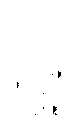
现在参看图1,其中描述了一种为特定的定位系统提供有意义的地面基准(ground reference)的方法。基准站150、152、154围绕建筑物110部署。这些基准站150、152、154可组成定位系统的基础设施的一部分,或者可简单地用做基准,例如用于初始化便携式惯性制导系统设备的速度模式。虽然这个例子中显示了三个这样的基准站,但是所需要的用于定位的基准站的数量是根据定位系统的技术和结构而变化的。在现有技术中,基准站150、152、154是地面基准(ground-referenced)(例如,通过判断它们的纬度和经度)的,(例如使用全球定位系统定位设备),并且这个地面基准将提供对建筑物的预先存在的地面基准地图的基准。然而,在许多情况下,建筑物的精确的地面基准定位或地面基准地图或楼层平面图是难以获得的。Referring now to FIG. 1, a method for providing a meaningful ground reference for a particular positioning system is depicted.
对于现场指挥(incident commander)(“IC”)100或其他人员来说,在火场环境中,通常在布置内部作业之前要先检查建筑物110的外部。在图1中,假定IC 100带着向基准站150、152、154提供相对位置的定位设备。这可以通过本领域公知的技术来实现,这些技术包括但不限于:测距(ranging)、入射角(angle of arrival)、抵达时间差(time difference of arrival)、接收信号强度、惯性制导或者这些技术的组合。这种设备可装备有可以让IC 100初始化或记录定位估计信息的手动控制器。通过在邻近建筑物110的转角111、112、113、114、115、116处激活控制器,集中式的系统就可以记录这些位置,IC 100通过连接与转角111、112、113、114、115、116相对应的位置估计171、172、173、174、175、176,就可以在显示器160上显示建筑物110的轮廓线170。由于我们知道IC 100的位置是相对于基准站150、152、154已知的,因此知道建筑物110的轮廓线170也是相对于基准站150、152、154已知的,并可以用作相对于基准站150、152、154的其它位置的基准。应当注意,根据本发明,并不需要表示基准站150、152、154的特征;它们只简单地为其它位置提供公共的基准。It is common for an incident commander ("IC") 100 or other personnel to inspect the exterior of a
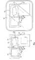
现在参看图2,其中显示了更完善的绘图解决方案。第一用户进入建筑物(在图中表示为区域270的楼层平面图)中,他沿着通路240前进、找到并通过门280进入房间272、在对面的墙上发现门281、最后到达定位点241。第二用户进入建筑物中,他沿着通路242前进、到达(travel up)并环绕房间274、最后到达定位点243。第三用户进入建筑物中,他沿着通路244前进并立即左转、到达定位点245。第四用户进入建筑物中,他沿着通路246前进并试图折回到通路240,但是发现这个走廊已不能通行;第四用户沿着通路246前进,绕房间272一周,发现门282,退出建筑物,最后到达定位点247。Referring now to Figure 2, a more complete drawing solution is shown. The first user enters the building (in the floor plan shown as
由于能见度很低,这些用户通常都会迷失方向并且不清楚他们的相对和绝对位置。其结果是在因结构危险、人员健康或空气供给不足而需要他们撤离的时候经常无法撤离。本发明的优选实施例假设每个用户都装备有类似于前面描述的IC 100所使用的定位装备。这样,他们的位置就可以在显示器160上示踪,在显示器上可能已经按前述方式画出了建筑物的轮廓线170。在现有的定位系统技术中,IC 100会注意到受影响用户的定位点243邻近于主入口283,所有的通道240、242、244、246都始于这个主入口;然而无论IC 100还是位于定位点243的第二用户都不能保证从定位点243到主入口283之间存在直接的退出通路。Due to poor visibility, these users are often disoriented and unclear about their relative and absolute positions. The result is that they are often unable to evacuate when required due to structural hazards, personnel health or insufficient air supply. The preferred embodiment of the present invention assumes that each user is equipped with positioning equipment similar to that used by IC 100 described above. In this way, their position can be tracked on the
根据本发明,显示器160可以选择不仅显示用户定位点241、243、245、247,而且还显示表示通路240、242、244、246的这些用户的定位历史。应当注意到,通路244从主入口283直接引到非常邻近第二用户的定位点243的点,IC 100可能就会推断出在定位点243和主入口283之间存在直接的通路。然而为了清楚起见,图2试图将通路之间的重叠最小化,在现实生活的情况中通路经常会重叠,这就让IC 100更加确信在点243和最短的退出通路244之间没有障碍。In accordance with the present invention,
这种改进在图2的右侧尤为明显。在这个情况中,位于定位点241的第一用户是需要撤离的。在现有的定位系统技术中,由于只有点241、243、245、247显示出来,所以IC100通常将引导位于定位点241处的第一用户经过门283撤离,而不能提供进一步的帮助。然后就要由第一用户来决定退出路径了;如果用户还没有迷失方向并且还记得他的进入通路,通过门280退出并按照进入的通路原路返回看上去是最好的选择。然而由本发明捕获的通路246的历史数据表明(现在位于定位点247的)第四用户在稍晚的时候曾尝试使用这个通路并发现它无法通行;预先表明必须要使用另外的退出路径。在注意到通路246和靠近门280的通路240相距不远之后,IC 100现在不但可以将位于定位点241处的第一用户引导到另外的通路,还可以清楚地推断出存在当前位于定位点247处的第四用户所使用过的通过门282的另外的通路,这表示存在一条比受影响用户的进入路线还要短的逃生路线。This improvement is especially noticeable on the right side of Figure 2. In this case, the first user at the
尽管为了清楚起见,上述例子过分地简化了并假设IC 100是手动地识别数据的,但是本领域普通技术人员应当理解,在现实环境中会提供更多的数据,并且通路之间的相关性和对障碍的推断在很大程度上都是由软件自动完成的。Although the above example is oversimplified for clarity and assumes that
超越了仅有的定位能力之外的附加传感能力的集成是本发明的进一步增强。图3图解说明了成像设备的使用,成像设备诸如在由Callaway等人于2001年4月20日申请的、名为“Intra-Piconet LocationDetermination and Tomography(微微网内定位判断和层析X射线摄影术)”的序列号为09/845,467的美国专利(代理人受理号:CM03372J),它与本申请一起由摩托罗拉公司所拥有,在此通过逐字地引用,并且通过与在这里全面和完全地提出来的相同的效果,将这个在先申请所公开的内容结合进来。The integration of additional sensing capabilities beyond the mere positioning capability is a further enhancement of the present invention. Figure 3 illustrates the use of an imaging device such as described in "Intra-Piconet Location Determination and Tomography" by Callaway et al. on April 20, 2001. )" U.S. Patent Serial No. 09/845,467 (Attorney Docket No. CM03372J), which is owned by Motorola, Inc. together with this To achieve the same effect, the content disclosed in this prior application is combined.
在优选的实施例中,部署了大量的设备(在图3中用黑点表示)。除了知道位置信息以外,这些设备还能够将传播环境特征化。尽管单个设备理论上可以通过探测它自身的信号的图像来将本地传播环境特征化,但是优选的实施例却是测量在发射设备和接收设备之间的传播特征。在具有上面所参考的序列号为09/845,467的美国专利的发明申请中描述了这两个设备是如何估计它们之间的射程并根据它们的距离和所测量出的传播效果来产生与设备相关的检测到的障碍的模型;然而本发明还可以让用于传播测量的两个或多个设备组以相对于基准设备的位置的形式将结果传送给集中式或分布式的环境模型。例如,可以看到设备组345可以特征化暗色的障碍344,它们是房间274的墙壁段或建筑物的外墙段。类似地,设备组341可以特征化暗色的障碍342,它们是房间272、276的墙壁段。当这些信息可能对这些组中的设备的用户有些用处的时候,本发明通过将设备的相对位置映射到公共的基准而可以极大地改善其他用户的值。本领域技术人员应当理解,通过来自设备345、341的层析X射线摄影结果,再加上所有可以让其成为可能的小设备,房间272、274、276的表示372、374、376可以相对于所建立的建筑物的轮廓170来构建,并如同在显示器160上所显示的,将它们集成到环境的相关地图中。这可以用来防止碰到邻近的障碍物。In the preferred embodiment, a large number of devices are deployed (indicated by black dots in Figure 3). In addition to knowing location information, these devices are also able to characterize the propagation environment. While a single device could theoretically characterize the local propagation environment by detecting its own image of the signal, the preferred embodiment measures the propagation characteristics between the transmitting device and the receiving device. How the two devices estimate the range between them and generate a correlation between the devices based on their distance and the measured propagation effects is described in the above-referenced US Patent Application Serial No. 09/845,467. A model of the detected obstacles; however, the invention also allows two or more groups of devices used for propagation measurements to communicate the results in the form of positions relative to a reference device to a centralized or distributed model of the environment. For example, it can be seen that device group 345 can feature dark colored obstacles 344 that are wall segments of
本领域技术人员应当理解,假设设备在一个时间间隔期间获得目标区域中的位置的大量统计数据,在这个时间间隔上目标区域的特征没有显著的变化,上述传播探测设备的多样性的功能可以由检测自身信号的反射图像的单个设备来完成,或者也可以由接收彼此信号的图像的至少两个设备来完成。Those skilled in the art should understand that assuming that the device obtains a large amount of statistical data of the position in the target area during a time interval, and the characteristics of the target area do not change significantly during this time interval, the above-mentioned function of propagating the diversity of detection devices can be obtained by This can be done by a single device detecting the reflected image of its own signal, or it can be done by at least two devices receiving images of each other's signals.
现在参看图4,图解说明了进一步扩展的系统,其中在系统数据库中集成了其它的环境参数。为了简单起见,由于温度比较简单和容易表示,所以用它作为相关环境参数的一个例子。图4图解说明了与上面说描述的相同的作业(attack)情况,但是这里带有用诸如那些用490系列的标签标明的条显示的周期性的温度读数。在读取数据的时候温度读数与传感器的位置相结合,并且可以显示来自不同传感器或相同传感器在不同时间测量到的结果。较长的条表示较高的温度。Referring now to FIG. 4, a further extended system is illustrated in which additional environmental parameters are integrated in the system database. For simplicity, temperature is used as an example of a relevant environmental parameter because it is relatively simple and easy to express. Figure 4 illustrates the same attack situation as described above, but here with periodic temperature readings shown with bars such as those labeled with the 490 series. Temperature readings are combined with sensor locations at the time of reading and can display results from different sensors or the same sensor measured at different times. Longer bars indicate higher temperatures.
沿着房间274的东北墙,可以看到,与位置估计452、454、458相对应的读数显示出比来自区域270中的其它设备的读数具有更高的温度读数492、494、498,这表示热源更接近于房间274的东北角,这由显示器160上的透视图374表示出来。来自位于房间374内的位置451处的设备的温度读数491进一步为这个估计提供了支持,它显示出在区域270中所有传感设备所测到的最高的温度。根据相关的位置数据和图像数据推断出热源在房间274中靠近东北角的地方是合理的。此外,温度读数497、498、499在比获得温度读数492、495晚的时候分别获得,温度读数492、495是在相同的地点但是较早的时间获得的。较早的温度读数492、495与较晚的温度读数497、498、499之间各自的差别可以用于推测火势发展的速度和方向。Along the northeast wall of
尽管为了清楚起见用这个例子描述了本发明,并且具体地说对结果的解释是启发式的和手动处理的,但是本领域技术人员应当理解,可以使用本领域任意数量的数字或算法的已知技术来部分地或完全地自动解释结果而不背离本发明。此外,得益于这里所描述的位置关联技术的测量不只限于上面所描述的成像和温度数据,它还包括这样一些数据:探测危险物质、爆炸物、易挥发的物质、标记的化学品或其它化学数据;测量湿度、气压、氧气、一氧化碳、二氧化碳、氡气的等级和其它大气数据;氧气、一氧化碳、二氧化碳、氡气和空气中的其它气体的等级;检测特殊的材料(例如:铁、金属、弹药等等);测量机械运动、地震扰动、来自活跃的声音活动的数据和其它运动;检测表示受害者或敌方存在的外部生命信号;检测或解释电磁或声音信号;相联系的用户的生命信号和设备状态的读数(例如,将剩余的生存时间和已知的退出路线相结合或标明没有被其它设备检测到的有压力效应(stress-inducing)环境影响的区域);和其它多得无法在这里一一列出的内容。Although the invention is described using this example for clarity, and in particular the interpretation of the results is heuristic and manually processed, it will be understood by those skilled in the art that any number of numerical or algorithmic known values in the art may be used techniques to partially or fully automatically interpret results without departing from the invention. Furthermore, the measurements that benefit from the position-correlation techniques described here are not limited to the imaging and temperature data described above, but include data that detect hazardous substances, explosives, volatile substances, labeled chemicals, or other Chemical data; measure humidity, air pressure, levels of oxygen, carbon monoxide, carbon dioxide, radon, and other atmospheric data; levels of oxygen, carbon monoxide, carbon dioxide, radon, and other gases in the air; detect special materials (eg, iron, metal , ammunition, etc.); measure mechanical motion, seismic disturbances, data from active acoustic activity, and other motion; detect external vital signs indicating the presence of a victim or enemy; detect or interpret electromagnetic or acoustic signals; vital signs and readouts of device status (e.g., combining remaining survival time with known exit routes or flagging areas of stress-inducing environments not detected by other devices); and more It's impossible to list them all here.
现在参看图5,流程图图解说明了在网络中开始于步骤500的本发明的操作,网络包括诸如由IC 100和在通路240、242、244、246中行进的其它用户所携带的定位/传感设备和部署在现场的其它设备以及与显示器160结合的单元、集中式的数据库、与这个数据库相关联的中央处理单元。这些功能可以是分布式的或合并在一个设备中。Referring now to FIG. 5, a flow diagram illustrates the operation of the present invention beginning at step 500 in a network including location/transmission data such as those carried by
在优选的实施例中,一旦无线通信设备判断(步骤502)出它们相对于基准站150、152、154的位置,就可以判断出一系列环境特征(步骤504),例如环境中对象或障碍物的出现和/或位置。一旦识别出相对于便携设备的对象,并且知道便携设备的位置,中央处理器就在环境中创建对象的透视图(即,草图、地图等等);由于发射和接收设备是已知的,并且知道反射信号的对象的距离,因此就可以估计出对象的位置。为了清楚起见,这里用结果的图形显示来描述透视图;然而,实际的透视图包括相关的对象或环境中的环境条件以及对象或环境条件的估计位置。透视图可以用各种方式来表示,只要它包含关于与位置估计相关的环境的信息就可以。In the preferred embodiment, once the wireless communication devices have determined (step 502) their position relative to the
类似地,无线设备确定一组它们所部署的环境的参数(步骤506)。优选地,每个无线通信设备都装备有至少一个传感器。所使用的传感器的类型根据具体的应用而定。例如,在火场环境中,传感器可能要测量温度、潮湿、毒素、湿度、运动等。一旦传感器从环境中收集到数据(例如,“热”点/危险区域的位置等),它就将数据直接或间接地发射到集中式的数据库。Similarly, wireless devices determine a set of parameters of the environment in which they are deployed (step 506). Preferably, each wireless communication device is equipped with at least one sensor. The type of sensor used depends on the specific application. For example, in a fire environment, sensors may want to measure temperature, humidity, toxins, humidity, motion, and more. Once a sensor collects data from the environment (eg, location of "hot" spots/hazardous areas, etc.), it transmits the data directly or indirectly to a centralized database.
访问集中式数据库的中央处理单元收集从多个设备接收到的各种信息(例如,设备的位置(步骤502)、环境的特征(步骤504)和环境的属性(步骤506))(步骤508)。如同本领域已知的,中央处理单元应用相对位置/距离技术和绘图算法,在显示器160上创建带有加载在透视图上的各种类型的信息的环境的透视图(步骤510)。一旦各种类型的信息结合在一起,带有加载在显示器160上的各种类型的信息的环境的透视图就生成了,显示器160可包括监视器、仰视显示器(heads-up display)、个人数字助理等。A central processing unit accessing a centralized database collects various information received from multiple devices (e.g., the location of the device (step 502), the characteristics of the environment (step 504), and the attributes of the environment (step 506)) (step 508) . As is known in the art, the central processing unit applies relative position/distance techniques and mapping algorithms to create a perspective view of the environment on the
中央处理单元持续从其它设备收集各种类型的信息并对环境的透视图进行相应地更新(步骤512),直到操作结束为止。The central processing unit continues to collect various types of information from other devices and updates the perspective of the environment accordingly (step 512) until the operation is complete.
尽管本发明是结合特定的实施例描述的,但是对于本领域技术人员来说很容易得到额外的好处和对它进行修改。因此本发明(在它更广泛的方面)并不局限于特定的细节、典型的装置以及所显示和描述的用于说明的例子。根据前面的描述,本领域技术人员容易看到它的各种变通、修改和变化。因此,应当理解,本发明并不局限于前面的描述,而是包括所有这些符合所附的权利要求书的精神和范围的变通、修改和变化。Although the invention has been described in connection with specific embodiments, additional benefits and modifications will readily occur to those skilled in the art. Therefore the invention (in its broader aspects) is not limited to the specific details, typical apparatus, and illustrative examples shown and described. From the foregoing description, various alterations, modifications and variations thereof will readily appear to those skilled in the art. It is therefore to be understood that the invention is not limited to the foregoing description, but includes all such alterations, modifications and variations that fall within the spirit and scope of the appended claims.
Claims (8)
Applications Claiming Priority (2)
| Application Number | Priority Date | Filing Date | Title |
|---|---|---|---|
| US10/145,257 | 2002-05-14 | ||
| US10/145,257US20030214410A1 (en) | 2002-05-14 | 2002-05-14 | System and method for inferring a set of characteristics of an environment with location-capable devices |
Publications (2)
| Publication Number | Publication Date |
|---|---|
| CN1533557A CN1533557A (en) | 2004-09-29 |
| CN100407235Ctrue CN100407235C (en) | 2008-07-30 |
Family
ID=29418604
Family Applications (1)
| Application Number | Title | Priority Date | Filing Date |
|---|---|---|---|
| CN038006685AExpired - Fee RelatedCN100407235C (en) | 2002-05-14 | 2003-05-01 | Method for inferring a set of characteristics of an environment using a device with location capabilities |
Country Status (5)
| Country | Link |
|---|---|
| US (1) | US20030214410A1 (en) |
| EP (1) | EP1504425A4 (en) |
| CN (1) | CN100407235C (en) |
| AU (1) | AU2003228801A1 (en) |
| WO (1) | WO2003098567A1 (en) |
Families Citing this family (28)
| Publication number | Priority date | Publication date | Assignee | Title |
|---|---|---|---|---|
| US7167715B2 (en)* | 2002-05-17 | 2007-01-23 | Meshnetworks, Inc. | System and method for determining relative positioning in AD-HOC networks |
| KR100752947B1 (en)* | 2003-06-06 | 2007-08-30 | 메시네트웍스, 인코포레이티드 | MAC protocol for accurately computing the position of wireless devices inside buildings |
| WO2006010071A2 (en)* | 2004-07-08 | 2006-01-26 | Meshnetworks, Inc. | System and method for tracking assets using an ad-hoc peer-to-peer wireless network |
| US8140261B2 (en) | 2005-11-23 | 2012-03-20 | Alcatel Lucent | Locating sensor nodes through correlations |
| EP2025178A2 (en)* | 2006-05-31 | 2009-02-18 | TRX Systems, Inc. | Method and system for locating and monitoring first responders |
| US9448072B2 (en) | 2007-05-31 | 2016-09-20 | Trx Systems, Inc. | System and method for locating, tracking, and/or monitoring the status of personnel and/or assets both indoors and outdoors |
| US9733091B2 (en) | 2007-05-31 | 2017-08-15 | Trx Systems, Inc. | Collaborative creation of indoor maps |
| US9395190B1 (en) | 2007-05-31 | 2016-07-19 | Trx Systems, Inc. | Crowd sourced mapping with robust structural features |
| AU2013204138B2 (en)* | 2007-08-06 | 2016-03-03 | Trx Systems, Inc. | Locating, tracking, and/or monitoring personnel and/or assets both indoors and outdoors |
| WO2009033001A2 (en)* | 2007-09-05 | 2009-03-12 | University Of Utah Research Foundation | Robust location distinction using teporal link signatures |
| US9068836B2 (en)* | 2007-10-18 | 2015-06-30 | Carlos Arteaga | Real-time location information system using multiple positioning technologies |
| US8515061B2 (en)* | 2008-09-11 | 2013-08-20 | The University Of Utah Research Foundation | Method and system for high rate uncorrelated shared secret bit extraction from wireless link characteristics |
| US8503673B2 (en) | 2008-09-11 | 2013-08-06 | University Of Utah Research Foundation | Method and system for secret key exchange using wireless link characteristics and random device movement |
| US8502728B2 (en)* | 2008-09-12 | 2013-08-06 | University Of Utah Research Foundation | Method and system for tracking objects using radio tomographic imaging |
| WO2010030950A2 (en) | 2008-09-12 | 2010-03-18 | University Of Utah Research Foundation | Method and system for detecting unauthorized wireless access points using clock skews |
| US9978251B2 (en)* | 2009-12-28 | 2018-05-22 | Honeywell International Inc. | Wireless location-based system and method for detecting hazardous and non-hazardous conditions |
| US8990049B2 (en)* | 2010-05-03 | 2015-03-24 | Honeywell International Inc. | Building structure discovery and display from various data artifacts at scene |
| US8818288B2 (en) | 2010-07-09 | 2014-08-26 | University Of Utah Research Foundation | Statistical inversion method and system for device-free localization in RF sensor networks |
| US20120016872A1 (en)* | 2010-07-13 | 2012-01-19 | Qualcomm Incorporated | Methods and apparatuses for use in generating an encoded routeability graph description |
| US8825388B2 (en) | 2010-07-13 | 2014-09-02 | Qualcomm Incorporated | Indoor likelihood heatmap |
| US11156464B2 (en) | 2013-03-14 | 2021-10-26 | Trx Systems, Inc. | Crowd sourced mapping with robust structural features |
| US11268818B2 (en) | 2013-03-14 | 2022-03-08 | Trx Systems, Inc. | Crowd sourced mapping with robust structural features |
| JP2014202690A (en)* | 2013-04-09 | 2014-10-27 | ソニー株式会社 | Navigation device and storage medium |
| EP3269180B1 (en)* | 2015-03-12 | 2020-11-25 | Honeywell International Inc. | Wireless mesh network gas detection real time location system and method |
| US10156552B2 (en) | 2015-05-13 | 2018-12-18 | Honeywell International Inc. | Method to auto-configure gas detectors based on real-time location |
| CN106600740B (en)* | 2016-12-12 | 2019-02-26 | 浪潮天元通信信息系统有限公司 | A kind of verification method and device transmitting outside line data |
| CN115917252A (en)* | 2020-06-15 | 2023-04-04 | 3M创新有限公司 | Personal protective equipment for navigation and map generation in hazardous environments using fiducial markers |
| CN118274856A (en)* | 2022-12-30 | 2024-07-02 | 华为技术有限公司 | Travel planning method, related device and communication system |
Citations (3)
| Publication number | Priority date | Publication date | Assignee | Title |
|---|---|---|---|---|
| US5016007A (en)* | 1985-04-19 | 1991-05-14 | Honda Giken Kogyo Kabushiki Kaisha | Apparatus for displaying travel path |
| US5552772A (en)* | 1993-12-20 | 1996-09-03 | Trimble Navigation Limited | Location of emergency service workers |
| US6198394B1 (en)* | 1996-12-05 | 2001-03-06 | Stephen C. Jacobsen | System for remote monitoring of personnel |
Family Cites Families (28)
| Publication number | Priority date | Publication date | Assignee | Title |
|---|---|---|---|---|
| US4468656A (en)* | 1981-06-24 | 1984-08-28 | Clifford Thomas J | Emergency signalling unit and alarm system for rescuing endangered workers |
| JPS6081698A (en)* | 1983-10-07 | 1985-05-09 | 東京電力株式会社 | Monitor and command guide system using electromagnetic wave |
| SE459539B (en)* | 1987-04-08 | 1989-07-10 | Jan Lennart Johansson | SECURITY SYSTEM INCLUDING A SIGNAL TRANSMITTER FOR TRANSFER OF CONDITION INFORMATION THROUGH A TELECOMMUNICATION CHANNEL |
| US4884067A (en)* | 1987-08-13 | 1989-11-28 | Talkie Tooter (Canada) Ltd. | Motion and position sensing alarm |
| EP0550517B1 (en)* | 1990-08-31 | 1998-12-23 | The General Hospital Corporation | A system for managing multiple devices, for example, portable patient monitoring devices in a network |
| US7310072B2 (en)* | 1993-10-22 | 2007-12-18 | Kopin Corporation | Portable communication display device |
| US5654690A (en)* | 1993-12-13 | 1997-08-05 | Brother Kogyo Kabushiki Kaisha | Fire alarm system |
| US6181253B1 (en)* | 1993-12-21 | 2001-01-30 | Trimble Navigation Limited | Flexible monitoring of location and motion |
| US5646629A (en)* | 1994-05-16 | 1997-07-08 | Trimble Navigation Limited | Memory cartridge for a handheld electronic video game |
| US5528248A (en)* | 1994-08-19 | 1996-06-18 | Trimble Navigation, Ltd. | Personal digital location assistant including a memory cartridge, a GPS smart antenna and a personal computing device |
| US5793882A (en)* | 1995-03-23 | 1998-08-11 | Portable Data Technologies, Inc. | System and method for accounting for personnel at a site and system and method for providing personnel with information about an emergency site |
| JP3425276B2 (en)* | 1995-08-11 | 2003-07-14 | 株式会社日立製作所 | Information notification system |
| US5774824A (en)* | 1995-08-24 | 1998-06-30 | The Penn State Research Foundation | Map-matching navigation system |
| US6006021A (en)* | 1996-07-01 | 1999-12-21 | Sun Microsystems, Inc. | Device for mapping dwellings and other structures in 3D |
| US6700493B1 (en)* | 1996-12-02 | 2004-03-02 | William A. Robinson | Method, apparatus and system for tracking, locating and monitoring an object or individual |
| AUPO609897A0 (en)* | 1997-04-09 | 1997-05-01 | Commonwealth Scientific And Industrial Research Organisation | Vital signs monitoring system |
| US6317029B1 (en)* | 1998-08-07 | 2001-11-13 | Aeroastro, Llc | In situ remote sensing |
| ATE347156T1 (en)* | 1998-10-14 | 2006-12-15 | Gary J Morris | HAZARD DETECTION SYSTEM WITH VOICE ALARM |
| US6182497B1 (en)* | 1999-08-20 | 2001-02-06 | Neodym Systems Inc | Gas detection system and method |
| JP4467709B2 (en)* | 2000-03-29 | 2010-05-26 | 本田技研工業株式会社 | Mobile navigation device |
| US6480783B1 (en)* | 2000-03-17 | 2002-11-12 | Makor Issues And Rights Ltd. | Real time vehicle guidance and forecasting system under traffic jam conditions |
| CA2403854C (en)* | 2000-03-22 | 2005-06-07 | Summit Industries, Inc. | A tracking, safety and navigation system for firefighters |
| US6317042B1 (en)* | 2000-05-01 | 2001-11-13 | Lucent Technologies Inc. | Automated emergency announcement system |
| US6580979B2 (en)* | 2000-07-10 | 2003-06-17 | Hrl Laboratories, Llc | Method and apparatus for terrain reasoning with distributed embedded processing elements |
| GB0027863D0 (en)* | 2000-11-15 | 2000-12-27 | Bligh Maurice | Emergency floor lighting system |
| US6650948B1 (en)* | 2000-11-28 | 2003-11-18 | Applied Generics Limited | Traffic flow monitoring |
| US6898559B2 (en)* | 2000-12-08 | 2005-05-24 | Tracker R&D, Llc | System for dynamic and automatic building mapping |
| US6594576B2 (en)* | 2001-07-03 | 2003-07-15 | At Road, Inc. | Using location data to determine traffic information |
- 2002
- 2002-05-14USUS10/145,257patent/US20030214410A1/ennot_activeAbandoned
- 2003
- 2003-05-01AUAU2003228801Apatent/AU2003228801A1/ennot_activeAbandoned
- 2003-05-01WOPCT/US2003/013610patent/WO2003098567A1/ennot_activeApplication Discontinuation
- 2003-05-01EPEP03726572Apatent/EP1504425A4/ennot_activeWithdrawn
- 2003-05-01CNCN038006685Apatent/CN100407235C/ennot_activeExpired - Fee Related
Patent Citations (3)
| Publication number | Priority date | Publication date | Assignee | Title |
|---|---|---|---|---|
| US5016007A (en)* | 1985-04-19 | 1991-05-14 | Honda Giken Kogyo Kabushiki Kaisha | Apparatus for displaying travel path |
| US5552772A (en)* | 1993-12-20 | 1996-09-03 | Trimble Navigation Limited | Location of emergency service workers |
| US6198394B1 (en)* | 1996-12-05 | 2001-03-06 | Stephen C. Jacobsen | System for remote monitoring of personnel |
Also Published As
| Publication number | Publication date |
|---|---|
| AU2003228801A1 (en) | 2003-12-02 |
| US20030214410A1 (en) | 2003-11-20 |
| EP1504425A4 (en) | 2007-09-19 |
| EP1504425A1 (en) | 2005-02-09 |
| WO2003098567A1 (en) | 2003-11-27 |
| CN1533557A (en) | 2004-09-29 |
Similar Documents
| Publication | Publication Date | Title |
|---|---|---|
| CN100407235C (en) | Method for inferring a set of characteristics of an environment using a device with location capabilities | |
| US7064660B2 (en) | System and method for inferring an electronic rendering of an environment | |
| Fischer et al. | Location and navigation support for emergency responders: A survey | |
| US10511951B2 (en) | Tracking and accountability device and system | |
| EP2179600B1 (en) | Locating, tracking, and/or monitoring people and/or assets both indoors and outdoors | |
| Krumm et al. | Locadio: Inferring motion and location from wi-fi signal strengths. | |
| US20160061607A1 (en) | System for determining the location of entrances and areas of interest | |
| AU2014277724B2 (en) | Locating, tracking, and/or monitoring personnel and/or assets both indoors and outdoors | |
| US20120173204A1 (en) | Building map generation using location and tracking data | |
| CN107942363A (en) | The fireman's indoor navigation system and its method calculated based on architecture structure drawing | |
| Wächter et al. | Dynamic evacuation system for the intelligent building based on beacons and handheld devices | |
| Saarinen et al. | Rescue personnel localization system | |
| US9858791B1 (en) | Tracking and accountability device and system | |
| HK1069659A (en) | System and method for inferring a set of characteristics of an environment with location-capable devices | |
| HK1069658A (en) | System and method for inferring an electronic rendering of an environment | |
| Li | A Radio Frequency Based Indoor Localization Framework for Supporting Building Emergency Response Operations | |
| HK1143688B (en) | Locating, tracking, and/or monitoring personnel and/or assets both indoors and outdoors |
Legal Events
| Date | Code | Title | Description |
|---|---|---|---|
| C06 | Publication | ||
| PB01 | Publication | ||
| C10 | Entry into substantive examination | ||
| SE01 | Entry into force of request for substantive examination | ||
| REG | Reference to a national code | Ref country code:HK Ref legal event code:DE Ref document number:1069659 Country of ref document:HK | |
| C14 | Grant of patent or utility model | ||
| GR01 | Patent grant | ||
| C56 | Change in the name or address of the patentee | Owner name:MOTOROLA SOLUTIONS INC. Free format text:FORMER NAME: MOTOROLA INC. | |
| CP03 | Change of name, title or address | Address after:Illinois State Patentee after:Motorala Solutions Address before:Illinois Patentee before:Motorola Inc. | |
| REG | Reference to a national code | Ref country code:HK Ref legal event code:WD Ref document number:1069659 Country of ref document:HK | |
| CF01 | Termination of patent right due to non-payment of annual fee | Granted publication date:20080730 Termination date:20200501 | |
| CF01 | Termination of patent right due to non-payment of annual fee |