Tracing Finland’s eastern border
We recount the tale of Finland’s eastern border, which has been drawn and redrawn many times.
The Vaalimaa border station in southeastern Finland, the oldest border station for road transport between Finland and Russia, opened in July 1958 (picture from 2000). Photo: Matti Karjanoja
The Finnish-Russian border has been redrawn many times during the past.
Finland’s eastern border was drawn for the first time between Sweden and Novgorod in 1323 in the Treaty of Nöteborg. It cut through the present Finnish territory from northwest to southeast, from Pyhäjoki in northern Ostrobothnia to the Karelian Isthmus. The areas to the south and west of the border, including Vyborg, belonged to Sweden, while the areas north and east of the border, including the northern parts of Finland, were Russian territory. For centuries, the border drawn in the Treaty would separate two cultures, religions and languages, and its impacts are still felt today. Finnish dialects can be roughly classified into eastern and western variants in accordance with this ancient divide.
First eastwards
Resurgent Sweden and Russia clashed a number of times during the ensuing centuries and most of the battles were fought on Finnish soil. The Treaty of Teusina, concluded in 1595, ended a bloody guerrilla war between the two countries (known as the Long Wrath) that had been raging for 25 years. Under the Treaty, the northern section of Finland’s eastern border made a great leap eastwards, reaching the Arctic Ocean. Those drawing the new border recognised the fact that Finnish tribes had already spread towards the east. The next redrawing came two decades later. Russia had been weakened by succession disputes and Sweden managed to occupy large areas of Russia located to the southeast of Finland, which were ceded to it in the Treaty of Stolbovo in 1617. As a result of its territorial gains, Sweden became one of the largest countries in Europe. For Karelians living in the areas now under Swedish rule, the redrawing of the border meant major changes. Sweden started to convert members of the Orthodox Church to the Protestant faith and imposed heavy taxes on them. As a result, a large number of Karelians moved to Russia and the westernmost Finnish tribes started settling in the areas conquered by Sweden.
Then westwards
Some 100 years later, in a war known as the Great Wrath, Tsar Peter the Great reconquered the areas Russia had ceded to Sweden in the 17th century. Under the Treaty of Uusikaupunki, which brought the conflict to a close, Finland’s eastern border was moved to more or less where it is today. Two decades later, Russians invaded Finland again. The occupation, known as the Little Wrath, ended with the Treaty of Turku under which the areas east of the Kymijoki River and those around Savonlinna were ceded to Russia.
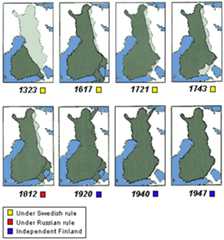
Finland’s eastern border 1323 – 1947.Map: The Karelian Association
Under the Treaty of Hamina in 1809, which ended the war between Sweden and Russia fought in 1808-1809, Finland was incorporated into Russia. Finland was granted autonomy, its pre-war administrative bodies remained in place, Protestantism remained the country’s religion, and the laws passed under the Swedish rule remained in force. In 1812, the parts of Karelia around Vyborg and to the north of Lake Ladoga were incorporated into the autonomous Grand Duchy of Finland. As a result, Finland’s eastern border now followed the course laid down in the Treaty of Stolbovo in 1617.
Borders of the independent Finland
Finland declared itself independent in December 1917. A state of war existed between Finland and Soviet Russia even though no major battles were fought. Russia recognised Finland’s independence and concluded a peace treaty with its northwestern neighbour. Under the treaty, signed in the Estonian town of Tartu in 1920, the northern area of Petsamo was incorporated into Finland, while Finland ceded the Karelian districts of Repola and Porajärvi to Russia.
Finland’s eastern border was redrawn for the last time during the Second World War following conflicts between Finland and the Soviet Union. Under an interim peace treaty in 1944, Finland again had to cede to the Soviet Union the areas around Vyborg and to the north of Lake Ladoga, the Petsamo area, and parts of the northern municipalities of Salla and Kuusamo. Almost the entire population of these areas, some 400,000 people, were resettled in different parts of Finland.
By Salla Korpela, June 2008
Links
Related posts
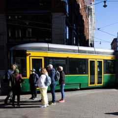
Trams carry the future in Helsinki and elsewhere in Finland
From the hum of the motor to the clatter of the tracks, people connect Helsinki’s trams with modern daily life and historical memories. This mode of transport will play a central role in the future of the capital and other cities in Finland.

Heads up for Helsinki’s urban overstory: Lions and gargoyles and bears, oh my!
If you elevate your gaze, Helsinki’s architecture contains surprising details. Mythical creatures, solemn figures and watchful animals perch high above street level.
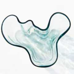
How Finnish glass design enchanted the world and keeps evolving
From kitchen cabinets to museum displays, Finnish glass design turns everyday objects into timeless art. Our reporter visits Finland’s last remaining glassworks and explores how a small country became a powerhouse of modern glass design.

A Finnish nurse aims to revolutionise elderly care
As the global population ages, the challenge of providing compassionate and sustainable care for older people becomes increasingly urgent. In Finland, a nation renowned for innovation in healthcare, a small-town nurse is championing a transformative model of foster care.