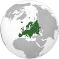
File:Europe orthographic Caucasus Urals boundary.svg
Page contents not supported in other languages.
Tools
Actions
In other projects

| DescriptionEurope orthographic Caucasus Urals boundary.svg | English: Map of Europe. The continental boundary to Asia as indicated is the standard convention following the Caucasus crest, the Ural River and the Urals Mountains to the Sea of Kara العربية: الخريطة الهجائية لأوروبا | ||||
| Date | |||||
| Source | This file was derived from:Europe (orthographic projection).svg:  bySsolbergj bySsolbergj | ||||
| Author | derivative work by Dbachmann | ||||
| Other versions | |||||
| SVG development InfoField |
|
| Public domainPublic domainfalsefalse |
| This map isineligible forcopyright and therefore in thepublic domain, because it consists entirely of information that is common property and contains no original authorship. For more information, seeCommons:Threshold of originality § Maps. العربية ∙Deutsch ∙English ∙español ∙galego ∙日本語 ∙română ∙slovenščina ∙中文 ∙中文(简体) ∙中文(繁體) ∙+/− |
This image is a derivative work of the following images:
Uploaded withderivativeFX
Click on a date/time to view the file as it appeared at that time.
| Date/Time | Thumbnail | Dimensions | User | Comment | |
|---|---|---|---|---|---|
| current | 13:32, 4 September 2022 |  | 537 × 536(77 KB) | M.Bitton | Reverted to version as of 12:03, 4 September 2022 (UTC): perCOM:OVERWRITE |
| 13:30, 4 September 2022 |  | 537 × 536(177 KB) | Рагин1987 | Small correction | |
| 12:03, 4 September 2022 |  | 537 × 536(77 KB) | M.Bitton | Reverted to version as of 05:48, 12 March 2019 (UTC): perCOM:OVERWRITE + fake svg | |
| 19:12, 30 August 2022 |  | 2,052 × 2,048(874 KB) | Рагин1987 | More correct visualization of the dividing line on the territory of the Caucasus Range | |
| 05:48, 12 March 2019 |  | 537 × 536(77 KB) | AndreyKva | Optimized. | |
| 19:25, 3 March 2016 |  | 537 × 536(197 KB) | Denniss | Reverted to version as of 13:27, 19 October 2014 (UTC) | |
| 18:37, 3 March 2016 |  | 537 × 536(239 KB) | Ercwlff | UC UC UC | |
| 13:27, 19 October 2014 |  | 537 × 536(197 KB) | Deni Mataev | Again, The entirety of Georgia is not in Europe geographically, only North Eastern parts are | |
| 20:05, 18 October 2014 |  | 537 × 536(238 KB) | Politologia | Reverted to version as of 10:57, 18 October 2014 In all maps Georgia is part of Georgia. There is at list 10 versions of borders of Europe in most of them Georgia is part of Europa | |
| 20:04, 18 October 2014 |  | 537 × 536(238 KB) | Politologia | Reverted to version as of 10:57, 18 October 2014 In all maps Georgia is part of Georgia. |
More than 100 pages use this file.The following list shows the first 100 pages that use this file only.Afull list is available.
Viewmore links to this file.
The following other wikis use this file:
Viewmore global usage of this file.
This file contains additional information, probably added from the digital camera or scanner used to create or digitize it.
If the file has been modified from its original state, some details may not fully reflect the modified file.
| Width | 536.58 |
|---|---|
| Height | 536.395 |