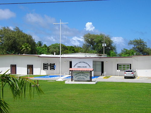
Capitol Hill Nakayama | |
|---|---|
Settlement | |
 Commonwealth of the Northern Mariana Islands Legislature Building at Capitol Hill | |
| Coordinates:15°12′00″N145°45′07″E / 15.2°N 145.751944°E /15.2; 145.751944 | |
| Territory | Northern Mariana Islands |
| Area | |
• Total | 1.48 sq mi (3.8 km2) |
| Population (2020)[1] | |
• Total | 979 |
| • Density | 661/sq mi (255/km2) |
| Website | www.gov.mp |
Capitol Hill (FormerJapanese name:中山,Nakayama; sometimes spelledCapital Hill,[2] formerlyArmy Hill under theUnited States Navy[3]) is a settlement (sometimes termed a village or district) on the island ofSaipan in theNorthern Mariana Islands.[4][5][6] It has a population of around 1,000.[1] Capitol Hill has been the territory'sseat of government since 1962. It lies on the cross-island road betweenTanapag andSan Vicente.
Capitol Hill was built in 1948 by theCentral Intelligence Agency as a base for covert training ofNationalist Chinese guerrillas.[7]
The area is home to various government departments and agencies:
Route 31 (Cross Island Road) or Isa Drive is the main road in the area.
| Climate data for Capitol Hill 1, Northern Mariana Islands (1991-2020 normals, extremes 1995-present) | |||||||||||||
|---|---|---|---|---|---|---|---|---|---|---|---|---|---|
| Month | Jan | Feb | Mar | Apr | May | Jun | Jul | Aug | Sep | Oct | Nov | Dec | Year |
| Record high °F (°C) | 88 (31) | 89 (32) | 89 (32) | 91 (33) | 92 (33) | 89 (32) | 91 (33) | 89 (32) | 90 (32) | 89 (32) | 90 (32) | 88 (31) | 92 (33) |
| Mean daily maximum °F (°C) | 80.9 (27.2) | 80.6 (27.0) | 81.7 (27.6) | 83.3 (28.5) | 84.6 (29.2) | 85.1 (29.5) | 84.6 (29.2) | 84.0 (28.9) | 84.0 (28.9) | 83.9 (28.8) | 83.7 (28.7) | 82.1 (27.8) | 83.2 (28.4) |
| Daily mean °F (°C) | 77.0 (25.0) | 76.6 (24.8) | 77.3 (25.2) | 78.6 (25.9) | 80.0 (26.7) | 80.3 (26.8) | 79.8 (26.6) | 79.5 (26.4) | 79.3 (26.3) | 79.3 (26.3) | 79.3 (26.3) | 78.1 (25.6) | 78.8 (26.0) |
| Mean daily minimum °F (°C) | 73.1 (22.8) | 72.7 (22.6) | 72.9 (22.7) | 73.8 (23.2) | 75.3 (24.1) | 75.5 (24.2) | 75.0 (23.9) | 74.9 (23.8) | 74.6 (23.7) | 74.7 (23.7) | 74.8 (23.8) | 74.1 (23.4) | 74.3 (23.5) |
| Record low °F (°C) | 68 (20) | 67 (19) | 62 (17) | 63 (17) | 66 (19) | 70 (21) | 62 (17) | 67 (19) | 64 (18) | 67 (19) | 68 (20) | 68 (20) | 62 (17) |
| Averageprecipitation inches (mm) | 4.57 (116) | 4.16 (106) | 3.12 (79) | 4.20 (107) | 4.04 (103) | 5.35 (136) | 9.62 (244) | 14.06 (357) | 11.90 (302) | 12.25 (311) | 8.27 (210) | 6.02 (153) | 87.56 (2,224) |
| Average precipitation days(≥ 0.01 in) | 19.3 | 18.0 | 15.8 | 17.9 | 19.2 | 22.3 | 25.4 | 26.5 | 24.2 | 24.7 | 22.4 | 22.1 | 257.8 |
| Source: NOAA[8][9] | |||||||||||||
 | ThisNorthern Marianas location article is astub. You can help Wikipedia byexpanding it. |