Street View Insights
Use Google Street View images to fuel geospatial insights.
Key features
Street View Insights helps you manage your infrastructure by offering powerful insights into the location and condition of public assets.
ML-ready format
Standardized annotations for immediate model training workflows.
Precise geolocation
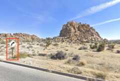
Every asset and image tagged with accurate GPS coordinates for spatial analysis.
Rich annotations
Detailed bounding boxes, asset types, and contextual metadata for each infrastructure element.
Archival data
Historical imagery for infrastructure change tracking and temporal analysis.
Quick start
Build powerful image analysis applications using Street View Insights. Query street-level imagery data, classify visual content with AI, and extract actionable intelligence from real-world observations.
Core specifications
Infrastructure types
Utility poles and road signs
Data formats
BigQuery tables, GeoJSON.
Coordinate system
WGS84.
Delivery methods
Google Cloud Storage, BigQuery.
Temporal coverage
Varies by region, with archival data available.
Common use cases
Urban planning
Target repairs for damaged insfrastructure more effectively, train computer vision models to assess damaged road signs and traffic lights, optimizing civic budgets.
Smart city infrastructure
Inventory and assess transportation, city, utility and telco infrastructure health
Traffic safety analysis
Identify missing or damaged signage, analyze accident-prone intersections, and validate as-builts for transportation authorities.

Except as otherwise noted, the content of this page is licensed under theCreative Commons Attribution 4.0 License, and code samples are licensed under theApache 2.0 License. For details, see theGoogle Developers Site Policies. Java is a registered trademark of Oracle and/or its affiliates.
Last updated 2025-12-16 UTC.