| | |  | Wallonia
| | |
| | Wallonie
Wallonien | |
| | Français | Wallonie -Région wallonne
LaRégion wallonne, communément appelée Wallonie, est l'une des trois régions constituant l'État belge. Elle représente le tiers de la population et 55% du territoire de la Belgique. Parmi les trois régions fédératives du Royaume de Belgique, la Région wallonne est l'une des deux régions majoritairement francophones, l'autre étant la Région de Bruxelles-Capitale. Traditionnellement, des ministres des deux régions se retrouvent dans le gouvernement de laCommunauté française de Belgique, ce qui justifie la désignation de cette dernière sous le nom de Communauté Wallonie-Bruxelles. La Wallonie représente à peu près 80% de cet ensemble. | | Deutsch | Wallonien -Wallonische Region
Wallonien, offiziellWallonische Region ist eine der drei Regionen Belgiens. Die Bevölkerung spricht vorwiegend französisch, im äußersten Osten deutsch. Die Hauptstadt ist Namur, das eigentliche kulturelle und wirtschaftliche Zentrum ist aber Lüttich. Geografisch umfasst Wallonien die südliche Hälfte Belgiens. Im Osten Walloniens befinded sich dieDeutschsprachige Gemeinschaft Belgiens. Sie ist mit rund 73.000 Einwohnern, mehrheitlich deutsch sprechender Staatsbürger, die kleinste der drei Gemeinschaften in Belgien. Die (Kultur-) Gemeinschaften entstanden 1983 im Zuge der Föderalisierung des zuvor zentral regierten Staates. Seitdem bezeichnet man in der Föderalismusforschung die DG als sogenannten Kleingliedstaat. | | Walon | Walonreye - Redjon walone
LiRedjon walone, c' est l' no oficir des institucions ki goviernèt l' Walonreye po tot çou ki compete di l' economeye, et totes sôres d' ôtès sacwès, apus ki l' acsegnmint eyet l' culteure, ki sont moennés pal kiminålté Walonreye-Brussele (eyet l' kiminålté tîxhon-cåzante po les comenes avou l' almand come lingaedje oficir). | | English | Wallonia - Walloon Region
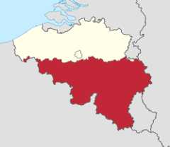
TheWalloon Region, commonly called Wallonia, is one of the three Regions of Belgium. The region represents 33% of the population and 55% of the territory of Belgium. It is predominantly French-speaking but there are also German-speaking communes in the east. Wallonia borders► Flanders, the► Netherlands,► France,► Germany and► Luxembourg.As the other regions, the Walloon Region has its own parliament and government and exercizes its functions by the limits defined by the Belgian constitution. Its capital is Namur. Its official languages are French and German.
TheFrench Community of Belgium is one of the three official communities in Belgium along with the Flemish Community and the German speaking Community. Although its name could suggest that it is a community of French citizens in Belgium, it is not. The French Community of Belgium is rather not a group of people or inhabitants, but an official institution of which the name refers to French-speaking Belgian citizens. As such, it is sometimes called the French-speaking Community of Belgium. The French Community of Belgium has its own parliament, government and administration.
Part of Wallonia is also theGerman-speaking Community of Belgium, one of the three federal communities in Belgium. It is the main part of the so-called East Cantons (German Ost-Kantone) of Belgium. It has an area of 854 km², and a population of over 71,000, of which almost 100% are German speaking (traditionally Ripuarian-speaking). Its capital is Eupen; it is part of the province of Liège and of the Walloon Region and borders on the► Netherlands,► Germany, and► Luxembourg. |
| | Short name | Wallonia | | Official name | Walloon Region | | Status | Region of► Belgium | | Capital | Namur (Region) & Bruxelles (Community) | | Population | 3,633,795 inhabitants | | Area | 16,844 km² | | Major languages | French, German | | Major religions | Roman Catholicism | | More information | Wallonia,Geography of Wallonia,History of Wallonia andPolitics of Wallonia | | More images | Wallonia -Wallonia (Category). |
|


