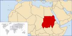
Movatterモバイル変換


[0]ホーム

URL:


Jump to content
Wikimedia Commons
Search

Atlas of Sudan

From Wikimedia Commons, the free media repository
Wikimedia Commons Atlas of the World

TheWikimedia Atlas of the World is an organized and commented collection of geographical, political and historical maps available atWikimedia Commons.
Discussion •Update the atlas •Index of the Atlas •Atlas in categories •Other atlases on line
The introductions of the country, dependency and region entries are in the native languages and in English. The other introductions are in English.
 
Atlas-country
Sudan


السودان
Sudan

     العربية[1]السودان - جمهورية السودان

السودان أكبر قطر في أفريقيا[بحاجة لمصدر]، السمة الرئيسية فيه هي نهر النيل وروافده، المرتبةالحادية عشر بين بلدان العالم الأكبرجمهورية السودان مساحة[بحاجة لمصدر].

العاصمة: الخرطوم وتعرف بالعاصمة المثلثة لأنها تتكون من ثلاثة مدن كبيرة وهى( الخرطوم - أم درمان - بحرى )

اسم القطر : الاسم الرسمي : جمهورية السودان والاسم القصير المتعارف عليه: السودان

الاستقلال: 1 يناير 1956م (الاستقلال من الحكم الثنائي مصر وبريطاني

EnglishSudan - Republic of Sudan

TheRepublic of Sudan is a country in North Africa. It is bordered by► Egypt to the north, the Red Sea to the northeast,► Eritrea and► Ethiopia to the east,► South Sudan to the south, and the► Central African Republic to the southwest,► Chad to the west, and► Libya to the northwest.


Short name  Sudan
Official nameRepublic of Sudan
StatusIndependent country since 1956
LocationNorth Africa
Capital[2] الخرطوم
Khartoum
Population41,984,500 inhabitants
Area2,505,813 square kilometres (967,500 sq mi)
LanguagesArabic, English (both official), indigenous languages like Nubian, Ta Bedawie, diverse dialects of Nilotic, Sudanic languages,
ReligionsIslam, Animism
More informationSudan,Geography of Sudan,History of Sudan andPolitics of Sudan
More imagesSudan -Sudan (Category).

General maps

Map of Sudan within Africa
General map of Sudan
Terrain map of Sudan
States of Sudan
Darfur states
Districts of Sudan

History maps

This section holds a short summary of the history of the area of present-day Sudan, illustrated with maps, including historical maps of former countries and empires that included present-day Sudan.

ChristianNubia Kingdoms
Kingdom of Aksum
TheMahdist State 1881-1898
1994 political map
Terrain map of Sudan (before 2011)
Map ofDarfur
Destroyed villages
Current political situation and factions within Sudan

Old maps

This section holds copies of original general maps more than 70 years old.

Map of Egypt and the Anglo-Egyptian Sudan
Upper Nubia and Abyssinia, 1891
Map of Egypt, Ethiopia and Sudan in 1892

Other maps

Transportation map
Oil and gas concessions
Sudan languages
Catholic dioceses
Oil and Gas

Satellite maps

Satellite map

Notes and references

General remarks:

  • The WIKIMEDIA COMMONS Atlas of the World is an organized and commented collection of geographical, political and historical maps available at Wikimedia Commons. The main page is therefore the portal tomaps andcartography on Wikimedia. That page contains links to entries by country, continent and by topic as well as generalnotes and references.
  • Every entry has an introduction section in English. If other languages are native and/or official in an entity, introductions in other languages are added in separate sections. The text of the introduction(s) is based on the content of the Wikipedia encyclopedia. For sources of the introduction see therefore the Wikipedia entries linked to. The same goes for the texts in the history sections.
  • Historical maps are included in the continent, country and dependency entries.
  • The status of various entities is disputed. See the content for the entities concerned.
  • The maps of former countries that are more or less continued by a present-day country or had a territory included in only one or two countries are included in the atlas of the present-day country. For example the Ottoman Empire can be found in theAtlas of Turkey.
  1. Romanization:Sūdān - Jumhūriyyat as-Sūdān.
  2. Romanization:al-Kharṭūm.

Entries available in the atlas

General pages
World
Continents and oceans
Themes
Historical eras
States with wide recognition
States with limited recognition
Dependencies and other overseas territories
Country subdivisions
Belgium
China (mainland)
India
Indonesia
Pakistan
Spain
United Kingdom
United States
Russia
Other
Disputed subnational territories
Other regions
Cities
Former sovereign states
Former dependencies and overseas territories
Former disputed territories

Maps of divisions

This section holds maps of the administrative divisions.

References

Retrieved from "https://commons.wikimedia.org/w/index.php?title=Atlas_of_Sudan&oldid=893273038"
Categories:
Hidden category:

[8]ページ先頭

©2009-2025 Movatter.jp