| | | Atlas-country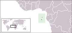 | São Tomé and Príncipe
| | |
| | São Tomé e Príncipe | |
| | Português | São Tomé e Príncipe - República Democrática de São Tomé e Príncipe
ARepública Democrática de São Tomé e Príncipe é um estado insular localizado no Golfo da Guiné, composto por duas ilhas principais (São Tomé e Príncipe) e várias ilhotas, num total de 964 km², com cerca de 120 mil habitantes. Estado insular, não tem fronteiras terrestres, mas situa-se relativamente próximo das costas do Gabão, Guiné Equatorial, Camarões e Nigéria. | | English | São Tomé and Príncipe - Democratic Republic of Sao Tome and Principe
TheDemocratic Republic of Sao Tome and Principe is an island nation in the Gulf of Guinea, off the western equatorial coast of Africa. It consists of two islands: São Tomé and Príncipe, located about 140 kilometres apart and about 250 and 225 kilometres respectively, off of the northwestern coast of► Gabon. Both islands are part of an extinct volcanic mountain range. São Tomé, the sizable southern island, is situated almost exactly on the equator. It is named after Saint Thomas by Portuguese explorers who discovered the island on his feast day. Sao Tome and Principe is the second smallest (in terms of population) African country (larger only than Seychelles). A neighboring island nation is► Equatorial Guinea. | |
| | Short name | São Tomé and Príncipe | | Official name | Democratic Republic of Sao Tome and Principe | | Status | Independent country since 1975 | | Location | Central Africa | | Capital | São Tomé | | Population | 210,240 inhabitants | | Area | 964 square kilometres (372 sq mi) | | Major languages | Portuguese (official) and Forro | | Major religions | Roman Catholicism | | More information | São Tomé and Príncipe,Geography of São Tomé and Príncipe,History of São Tomé and Príncipe andPolitics of São Tomé and Príncipe | | More images | São Tomé and Príncipe -São Tomé and Príncipe (Category). |
|


.jpg)


