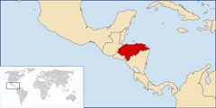
Movatterモバイル変換


[0]ホーム

URL:


Jump to content
Wikimedia Commons
Search

Atlas of Honduras

From Wikimedia Commons, the free media repository
Wikimedia Commons Atlas of the World

TheWikimedia Atlas of the World is an organized and commented collection of geographical, political and historical maps available atWikimedia Commons.
Discussion •Update the atlas •Index of the Atlas •Atlas in categories •Other atlases on line
The introductions of the country, dependency and region entries are in the native languages and in English. The other introductions are in English.
 
Atlas-country
Honduras


Honduras

EspañolHonduras - República de Honduras

LaRepública de Honduras se localiza en la América Central. Limita al norte con el Mar Caribe en el cual posee numerosas islas, cayos e islotes de las cuales las más importantes son las Islas de la Bahía y las Islas del Cisne, al este con el Mar Caribe y Nicaragua, al oeste con Guatemala y al sur con el Golfo de Fonseca, El Salvador y Nicaragua.

EnglishHonduras - Republic of Honduras

TheRepublic of Honduras is a country in Central America, bordered to the west by► Guatemala, to the southwest by► El Salvador, to the southeast by► Nicaragua, to the south by the Pacific Ocean, at the Golf of Fonseca, and to the north by the Gulf of Honduras and the Caribbean Sea.


Short name  Honduras
Official nameRepublic of Honduras
StatusIndependent country since 1838
LocationCentral America
CapitalTegucigalpa
Population9,304,380 inhabitants
Area112,492 square kilometres (43,433 sq mi)
Languages  Spanish (official)
ReligionsRoman Catholicism
More informationHonduras,Geography of Honduras,History of Honduras andPolitics of Honduras
More imagesHonduras -Honduras (Category).

General maps

Mapa de Honduras
Map of Honduras
Shaded relief map of Honduras
Mapa de Honduras
Map of Honduras
Departments of Honduras
Municipalities of Honduras

History maps

This section holds a short summary of the history of the area of present-day Honduras, illustrated with maps, including historical maps of former countries and empires that included present-day Honduras.

Lacivilización maya
Maya civilization
Maya civilization compared with present states
Lenguas Mayas
Maya languages
Federal Republic of Central America

Old maps

This section holds copies of original general maps more than 70 years old.

América central en 1892
Central America in 1892

Economical maps

Mapa de la actividad económica en Honduras
Economic activity map of Honduras
Land use map of Honduras

Satellite maps

Satellite map

Notes and references

General remarks:

  • The WIKIMEDIA COMMONS Atlas of the World is an organized and commented collection of geographical, political and historical maps available at Wikimedia Commons. The main page is therefore the portal tomaps andcartography on Wikimedia. That page contains links to entries by country, continent and by topic as well as generalnotes and references.
  • Every entry has an introduction section in English. If other languages are native and/or official in an entity, introductions in other languages are added in separate sections. The text of the introduction(s) is based on the content of the Wikipedia encyclopedia. For sources of the introduction see therefore the Wikipedia entries linked to. The same goes for the texts in the history sections.
  • Historical maps are included in the continent, country and dependency entries.
  • The status of various entities is disputed. See the content for the entities concerned.
  • The maps of former countries that are more or less continued by a present-day country or had a territory included in only one or two countries are included in the atlas of the present-day country. For example the Ottoman Empire can be found in theAtlas of Turkey.

Entries available in the atlas

General pages
World
Continents and oceans
Themes
Historical eras
States with wide recognition
States with limited recognition
Dependencies and other overseas territories
Country subdivisions
Belgium
China (mainland)
India
Indonesia
Pakistan
Spain
United Kingdom
United States
Russia
Other
Disputed subnational territories
Other regions
Cities
Former sovereign states
Former dependencies and overseas territories
Former disputed territories
Retrieved from "https://commons.wikimedia.org/w/index.php?title=Atlas_of_Honduras&oldid=1033752448"
Categories:
Hidden category:

[8]ページ先頭

©2009-2025 Movatter.jp