| AK | AL | AR | AZ | CA | CO | CT |
| FL | GA | HI | IA | ID | IL | IN |
| KS |
 Jump to a detailed profile, search site with google or try
- All Cities
- Connecticut,CT smaller cities,CT small cities
- Litchfield County
- Cornwall, CT housing info
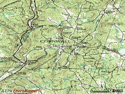
- Cornwall, Connecticut
Cornwall, Connecticut
Submit your own pictures of this town and show them to the world
- OSM Map
- General Map
- Google Map
- MSN Map
- OSM Map
- General Map
- Google Map
- MSN Map

- OSM Map
- General Map
- Google Map
- MSN Map
- OSM Map
- General Map
- Google Map
- MSN Map
Please wait while loading the map...
Population change since 2000: -1.0%
| Males: 704 | |
| Females: 716 |
| Median resident age: | 50.1 years |
| Connecticut median age: | 39.2 years |
Zip codes:06754.
| Cornwall: | $93,281 |
| CT: | $91,665 |
Estimated per capita income in 2023: $78,451 (it was $42,484in 2000)
Cornwall town income, earnings, and wages data
Estimated median house or condo value in 2023: $551,013 (it was $240,600in 2000)
| Cornwall: | $551,013 |
| CT: | $367,800 |
Mean prices in 2023:all housing units: $477,310;detached houses: $494,716;townhouses or other attached units: $436,280;in 2-unit structures: $205,464;in 3-to-4-unit structures: $432,278;in 5-or-more-unit structures: $179,157;mobile homes: $152,137
Detailed information about poverty and poor residents in Cornwall, CT


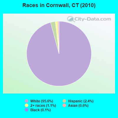
- 1,35795.6%White alone
- 342.4%Hispanic
- 161.1%Two or more races
- 90.6%Asian alone
- 20.1%Black alone
- 10.07%American Indian alone
- 10.07%Other race alone
Races in Cornwall detailed stats: ancestries, foreign born residents, place of birth
 Recent articles from our blog. Our writers, many of them Ph.D. graduates or candidates, create easy-to-read articles on a wide variety of topics.

 | 2024 Connecticut Town Tournament VI (Celebrating the 10-Year Anniversary & Dazzleman's Memorial) (1225 replies) |
| Current Real estate markets (3987 replies) |
| Connecticut TOWN TOURNAMENT V (2022) (831 replies) |
| Connecticut’s Covered Bridges (18 replies) |
| Sharon and Cornwall (14 replies) |
| Connecticut Weather Discussion (9637 replies) |
Latest news from Cornwall, CT collected exclusively by city-data.com from local newspapers, TV, and radio stations
Cornwall, CT City Guides:
Ancestries:English (26.1%),Irish (18.5%),German (17.5%),Italian (7.1%),United States (6.3%),Scottish (5.9%).
Current Local Time: EST time zone
Incorporated on05/1740
Elevation: 718 feet
Land area: 46.0square miles.
Population density: 31people per square mile (very low).

88 residents are foreign born(3.8%Europe, 1.3%Asia).
| This town: | 6.1% |
| Connecticut: | 10.9% |
| Cornwall town: | 1.0% ($2,496) |
| Connecticut: | 1.8% ($2,961) |
Nearest city with pop. 50,000+:Bristol, CT (23.6 miles
, pop. 60,062).
Nearest city with pop. 200,000+:Bronx, NY (74.5 miles
, pop. 1,332,650).
Nearest cities:
Latitude: 41.85 N, Longitude: 73.34 W
Area code: 860

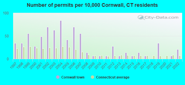
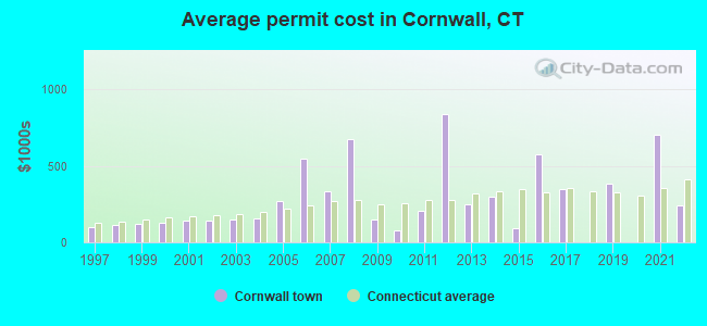
Single-family new house construction building permits:
- 2022: 3buildings, average cost: $239,700
- 2021: 1building, cost: $700,000
- 2019: 5buildings, average cost: $386,000
- 2017: 1building, cost: $345,000
- 2016: 2buildings, average cost: $575,000
- 2015: 1building, cost: $95,000
- 2014: 2buildings, average cost: $300,000
- 2013: 1building, cost: $250,000
- 2012: 4buildings, average cost: $837,500
- 2011: 1building, cost: $205,000
- 2010: 1building, cost: $80,000
- 2009: 1building, cost: $150,000
- 2008: 2buildings, average cost: $676,700
- 2007: 8buildings, average cost: $333,100
- 2006: 10buildings, average cost: $547,500
- 2005: 6buildings, average cost: $266,700
- 2004: 12buildings, average cost: $155,600
- 2003: 9buildings, average cost: $151,200
- 2002: 10buildings, average cost: $144,400
- 2001: 7buildings, average cost: $139,700
- 2000: 4buildings, average cost: $129,300
- 1999: 8buildings, average cost: $120,400
- 1998: 5buildings, average cost: $114,900
- 1997: 5buildings, average cost: $95,500
| Here: | 1.8% |
| Connecticut: | 2.7% |
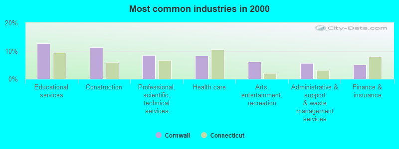
- Educational services (12.7%)
- Construction (11.3%)
- Health care & social assistance (10.7%)
- Retail trade (10.4%)
- Professional, scientific, technical services (8.5%)
- Arts, entertainment, recreation (6.2%)
- Administrative & support & waste management services (5.7%)
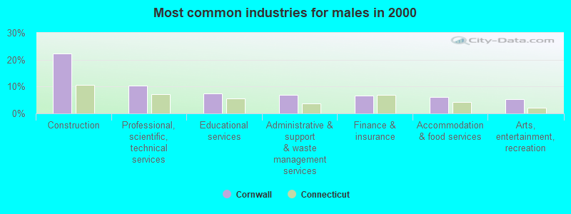
- Construction (22.2%)
- Professional, scientific, technical services (10.5%)
- Retail trade (8.0%)
- Educational services (7.5%)
- Administrative & support & waste management services (7.0%)
- Finance & insurance (6.7%)
- Accommodation & food services (6.0%)
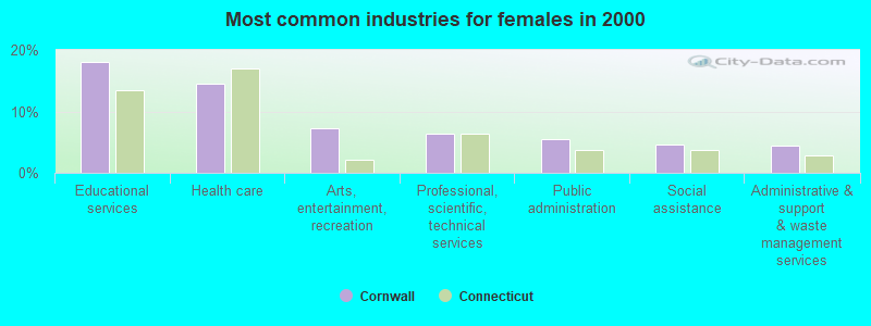
- Health care & social assistance (19.1%)
- Educational services (18.1%)
- Retail trade (12.9%)
- Arts, entertainment, recreation (7.2%)
- Professional, scientific, technical services (6.5%)
- Public administration (5.4%)
- Other services, except public administration (5.2%)
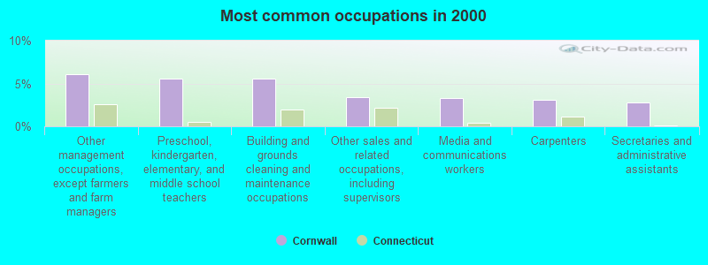
- Other management occupations, except farmers and farm managers (6.1%)
- Preschool, kindergarten, elementary, and middle school teachers (5.6%)
- Building and grounds cleaning and maintenance occupations (5.6%)
- Other sales and related occupations, including supervisors (3.4%)
- Media and communications workers (3.3%)
- Carpenters (3.0%)
- Secretaries and administrative assistants (2.8%)
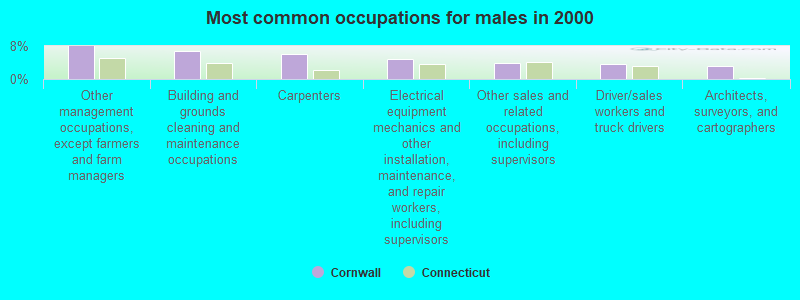
- Other management occupations, except farmers and farm managers (8.0%)
- Building and grounds cleaning and maintenance occupations (6.7%)
- Carpenters (6.0%)
- Electrical equipment mechanics and other installation, maintenance, and repair workers, including supervisors (4.7%)
- Other sales and related occupations, including supervisors (4.0%)
- Driver/sales workers and truck drivers (3.7%)
- Architects, surveyors, and cartographers (3.2%)
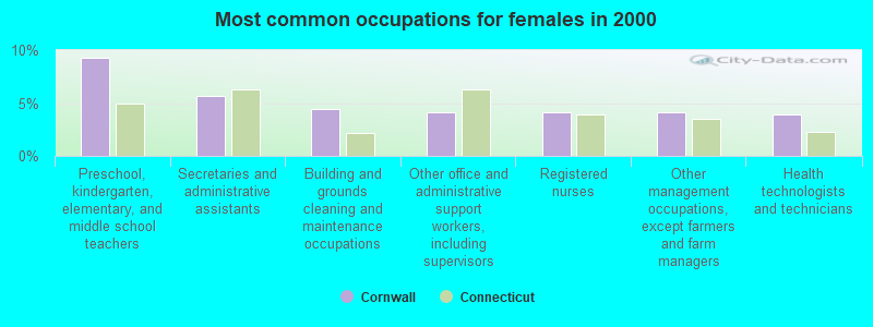
- Preschool, kindergarten, elementary, and middle school teachers (9.3%)
- Secretaries and administrative assistants (5.7%)
- Building and grounds cleaning and maintenance occupations (4.4%)
- Other office and administrative support workers, including supervisors (4.1%)
- Registered nurses (4.1%)
- Other management occupations, except farmers and farm managers (4.1%)
- Health technologists and technicians (3.9%)
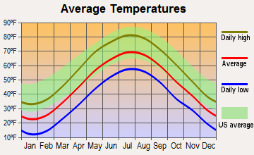
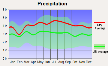
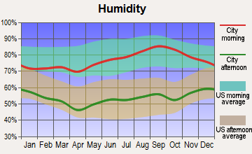
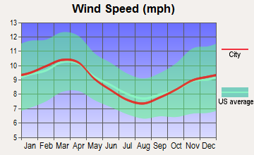
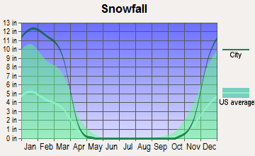
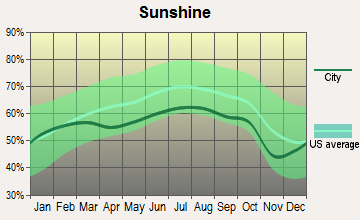
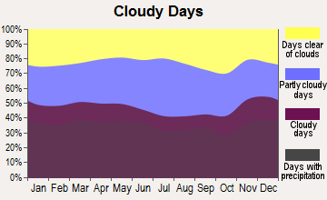
Average climate in Cornwall, Connecticut
Based on data reported by over 4,000 weather stations
(lower is better)
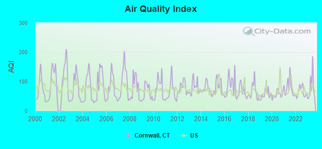
Air Quality Index (AQI) level in 2023 was79.4. This is about average.
| City: | 79.4 |
| U.S.: | 72.6 |
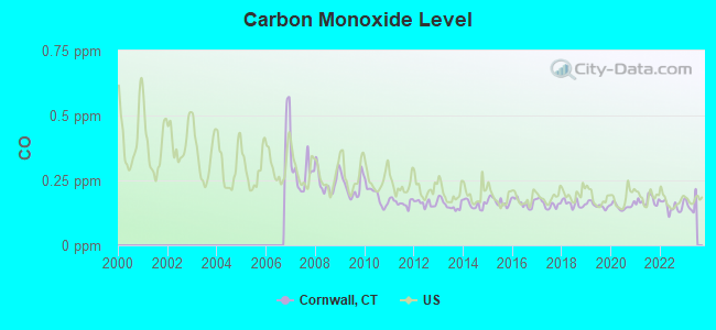
Carbon Monoxide (CO) [ppm] level in 2022 was0.149. This is significantly better than average.Closest monitor was 2.6 miles away from the city center.
| City: | 0.149 |
| U.S.: | 0.251 |
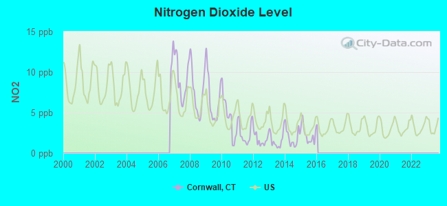
Nitrogen Dioxide (NO2) [ppb] level in 2015 was2.27. This is significantly better than average.Closest monitor was 2.6 miles away from the city center.
| City: | 2.27 |
| U.S.: | 5.11 |
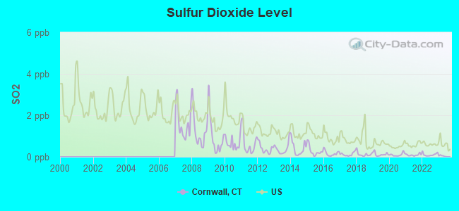
Sulfur Dioxide (SO2) [ppb] level in 2022 was0.109. This is significantly better than average.Closest monitor was 2.6 miles away from the city center.
| City: | 0.109 |
| U.S.: | 1.515 |
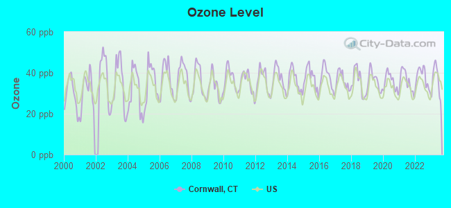
Ozone [ppb] level in 2023 was36.2. This is about average.Closest monitor was 2.6 miles away from the city center.
| City: | 36.2 |
| U.S.: | 33.3 |
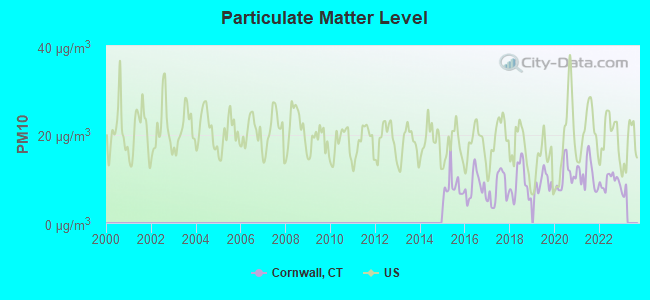
Particulate Matter (PM10) [µg/m3] level in 2022 was9.49. This is significantly better than average.Closest monitor was 2.6 miles away from the city center.
| City: | 9.49 |
| U.S.: | 19.21 |
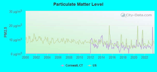
Particulate Matter (PM2.5) [µg/m3] level in 2022 was4.86. This is significantly better than average.Closest monitor was 2.6 miles away from the city center.
| City: | 4.86 |
| U.S.: | 8.11 |
Tornado activity:
Cornwall-area historical tornado activity is slightly aboveConnecticut state average. It is 19%smaller than the overall U.S. average.
On5/29/1995, acategoryF4 (max. wind speeds 207-260 mph)tornado24.0miles away from the Cornwall town centerkilled 3peopleand injured 24peopleand causedbetween $5,000,000and $50,000,000in damages.
On8/28/1973, acategoryF4tornado29.5miles away from the town centerkilled 4peopleand injured 36peopleand causedbetween $5,000,000and $50,000,000in damages.
Earthquake activity:
Cornwall-area historical earthquake activity issignificantly above Connecticut state average. It is69% smallerthan the overall U.S. average.On10/7/1983at10:18:46, a magnitude 5.3 (5.1 MB,5.3 LG,5.1 ML, Class: Moderate, Intensity: VI - VII)earthquake occurred 154.5miles away from the city center
On4/20/2002at10:50:47, a magnitude 5.3 (5.3 ML, Depth:3.0 mi)earthquake occurred 185.4miles away from the city center
On4/20/2002at10:50:47, a magnitude 5.2 (5.2 MB,4.2 MS,5.2 MW,5.0 MW)earthquake occurred 183.7miles away from the city center
On1/19/1982at00:14:42, a magnitude 4.7 (4.5 MB,4.7 MD,4.5 LG, Class: Light, Intensity: IV - V)earthquake occurred 144.5miles away from Cornwall center
On8/23/2011at17:51:04, a magnitude 5.8 (5.8 MW, Depth:3.7 mi)earthquake occurred 365.6miles away from Cornwall center
On10/16/2012at23:12:25, a magnitude 4.7 (4.7 ML, Depth:10.0 mi)earthquake occurred 182.3miles away from Cornwall center
Magnitude types: regional Lg-wave magnitude (LG), body-wave magnitude (MB), duration magnitude (MD), local magnitude (ML), surface-wave magnitude (MS), moment magnitude (MW)
Natural disasters:
The number of natural disasters in Litchfield County(23) isgreaterthan the US average (19).Major Disasters (Presidential) Declared: 13
Emergencies Declared: 10
Causes of natural disasters:Storms:7, Hurricanes:5, Floods:4, Snowstorms:4, Blizzards:3, Snows:2, Tropical Storms:2, Winter Storms:2, Snowfall:1, Tornado:1, Wind:1 (Note: some incidents may be assigned to more than one category).
Hospitals and medical centers near Cornwall:
- GEER NURSING AND REHABILITATIO(Nursing Home, about 8 miles away; CANAAN, CT)
- SHARON HEALTH CARE CENTER(Nursing Home, about 8 miles away; SHARON, CT)
- SHARON HOSPITALAcute Care Hospitals(about 9 miles away; SHARON, CT)
- ROSE HAVEN, LTD(Nursing Home, about 10 miles away; LITCHFIELD, CT)
- L A R C: BERTOLI DRIVE(Hospital, about 10 miles away; LITCHFIELD, CT)
- LITCHFIELD WOODS HEALTH CARE C(Nursing Home, about 11 miles away; TORRINGTON, CT)
- TORRINGTON HEALTH AND REHABILITATION CENTER(Nursing Home, about 11 miles away; TORRINGTON, CT)
Colleges/universities with over 2000 students nearest to Cornwall:
- Naugatuck Valley Community College (about 25miles; Waterbury, CT;Full-time enrollment: 4,491)
- Post University (about 26miles; Waterbury, CT;FT enrollment: 5,808)
- University of Connecticut-Tri-Campus (about 26miles; Waterbury, CT;FT enrollment: 2,250)
- Tunxis Community College (about 26miles; Farmington, CT;FT enrollment: 2,787)
- Dutchess Community College (about 31miles; Poughkeepsie, NY;FT enrollment: 6,554)
- Vassar College (about 31miles; Poughkeepsie, NY;FT enrollment: 2,469)
- Central Connecticut State University (about 32miles; New Britain, CT;FT enrollment: 9,989)
Public elementary/middle school in Cornwall:
- CORNWALL CONSOLIDATED SCHOOL(Students: 135,Location: 5 CREAM HILL ROAD,Grades:KG-8)
Points of interest:
North Cornwall Meeting House.Display/hide its location on the map
Cornwall Cemetery, Sedgwick Cemetery, Southeast Cemetery, Wright Cemetery, Allen Cemetery.Display/hide their locations on the map
Clark Pond, Cream Hill Lake, Wilford Pond, Hart Pond, Hawkins Pond, Hedden Pond, Mohawk Pond, Nash Pond.Display/hide their locations on the map
Mill Brook, Millard Brook, Ocain Brook, Reed Brook, Spruce Brook, Adams Brook, Baldwin Brook, Birdseye Brook, Bloody Brook.Display/hide their locations on the map
Mohawk State Park.Display/hide its location on the map
Birthplace of: John Sedgwick- Union Army general, George R. Gold- Politician, Major Andre Andrews- Politician.
| This town: | 2.3 people |
| Connecticut: | 2.5 people |
| This town: | 64.0% |
| Whole state: | 66.3% |
| This town: | 6.4% |
| Whole state: | 6.6% |
Likely homosexual households (counted as self-reported same-sex unmarried-partner households)
- Lesbian couples: 0.8%of all households
- Gay men: 0.5%of all households
| This town: | 3.0% |
| Whole state: | 7.9% |
| This town: | 1.2% |
| Whole state: | 3.9% |
For population 15 years and over in Cornwall:
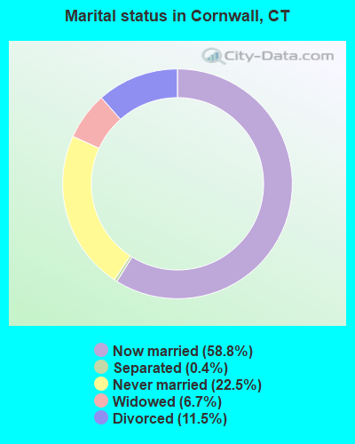
- Never married: 22.5%
- Now married: 58.8%
- Separated: 0.4%
- Widowed: 6.7%
- Divorced: 11.5%
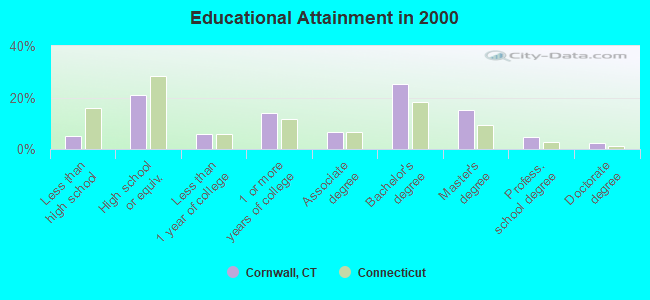
For population 25 years and over in Cornwall:
- High school or higher: 94.8%
- Bachelor's degree or higher: 47.4%
- Graduate or professional degree: 22.2%
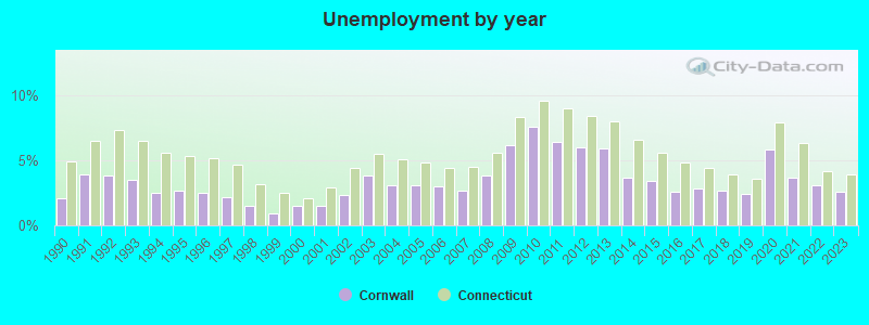
- Unemployed: 1.5%
- Mean travel time to work (commute): 33.2 minutes
| Here: | 10.6 |
| Connecticut average: | 12.8 |
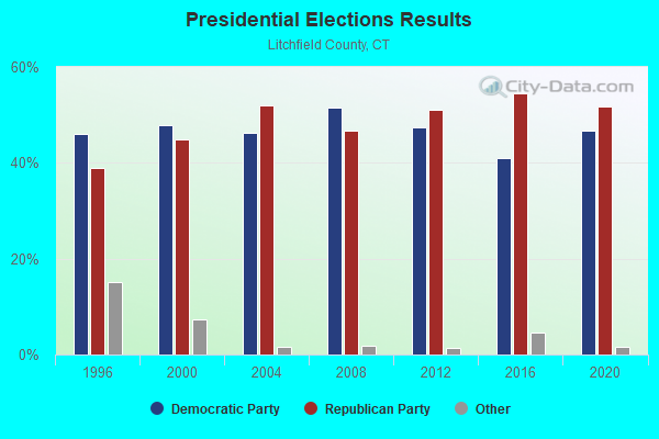
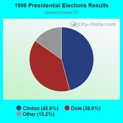
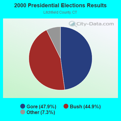
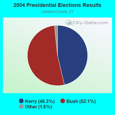
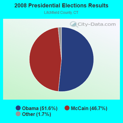
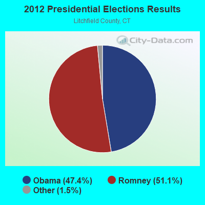
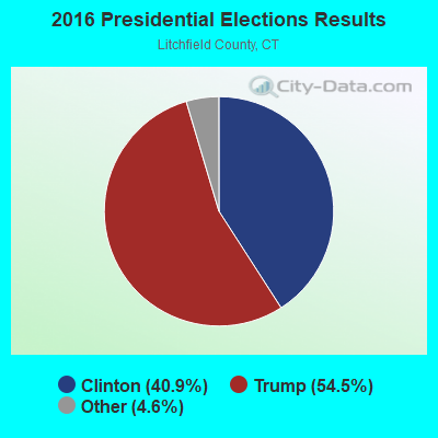
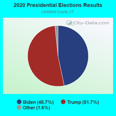

Graphs represent county-level data.Detailed 2008 Election Results
Religion statistics for Cornwall, CT (based on Litchfield County data)
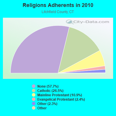
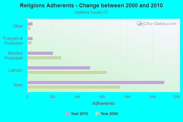
| Religion | Adherents | Congregations |
|---|---|---|
| Catholic | 50,354 | 30 |
| Mainline Protestant | 20,681 | 87 |
| Evangelical Protestant | 4,483 | 39 |
| Other | 4,420 | 16 |
| Orthodox | 175 | 2 |
| Black Protestant | 160 | 2 |
| None | 109,654 | - |
Food Environment Statistics:
| This county: | 2.29 / 10,000 pop. |
| Connecticut: | 2.21 / 10,000 pop. |
| Litchfield County: | 0.05 / 10,000 pop. |
| Connecticut: | 0.07 / 10,000 pop. |
| Litchfield County: | 0.64 / 10,000 pop. |
| State: | 1.02 / 10,000 pop. |
| Litchfield County: | 2.98 / 10,000 pop. |
| State: | 2.27 / 10,000 pop. |
| Litchfield County: | 11.07 / 10,000 pop. |
| State: | 9.19 / 10,000 pop. |
| This county: | 6.9% |
| Connecticut: | 7.3% |
| This county: | 21.1% |
| State: | 21.5% |
| Litchfield County: | 11.8% |
| Connecticut: | 15.8% |
Strongest AM radio stations in Cornwall:
- WTIC (1080 AM; 50 kW; HARTFORD, CT;Owner: INFINITY RADIO OPERATIONS INC.)
- WNNZ (640 AM; 50 kW; WESTFIELD, MA;Owner: CLEAR CHANNEL BROADCASTING LICENSES, INC.)
- WFAN (660 AM; 50 kW; NEW YORK, NY;Owner: INFINITY BROADCASTING OPERATIONS, INC.)
- WKZE (1020 AM; daytime; 2 kW; SHARON, CT;Owner: JOHNSON DEVELOPMENT, INC.)
- WMCA (570 AM; 50 kW; NEW YORK, NY;Owner: SALEM MEDIA OF NEW YORK, LLC)
- WGY (810 AM; 50 kW; SCHENECTADY, NY;Owner: CLEAR CHANNEL BROADCASTING LICENSES, INC.)
- WCBS (880 AM; 50 kW; NEW YORK, NY;Owner: INFINITY BROADCASTING OPERATIONS, INC.)
- WABC (770 AM; 50 kW; NEW YORK, NY;Owner: WABC-AM RADIO, INC.)
- WOR (710 AM; 50 kW; NEW YORK, NY;Owner: BUCKLEY BROADCASTING CORPORATION)
- WCRN (830 AM; 50 kW; WORCESTER, MA;Owner: CARTER BROADCASTING CORPORATION)
- WPTR (1540 AM; 50 kW; ALBANY, NY;Owner: KIMTRON, INC.)
- WINS (1010 AM; 50 kW; NEW YORK, NY;Owner: INFINITY BROADCASTING OPERATIONS, INC.)
- WEPN (1050 AM; 50 kW; NEW YORK, NY;Owner: NEW YORK AM RADIO, LLC)
Strongest FM radio stations in Cornwall:
- W218AV (91.5 FM; WARREN, CT;Owner: MONROE BOARD OF EDUCATION)
- WQQQ (103.3 FM; SHARON, CT;Owner: THE RIDGEFIELD BROADCASTING CORPORATION)
- W206AW (89.1 FM; PAWLING, NY;Owner: SOUND OF LIFE, INC.)
- WKZE-FM (98.1 FM; SALISBURY, CT;Owner: JOHNSON DEVELOPMENT, INC.)
- WZBG (97.3 FM; LITCHFIELD, CT;Owner: LOCAL GIRLS & BOYS B/CASTING CORP.)
- WAPJ (89.9 FM; TORRINGTON, CT;Owner: NUTMEG CONSERVATORY FOR THE ARTS, INC.)
- WRCH (100.5 FM; NEW BRITAIN, CT;Owner: INFINITY RADIO OPERATIONS INC.)
- WAMQ (105.1 FM; GREAT BARRINGTON, MA;Owner: WAMC)
- WPDH (101.5 FM; POUGHKEEPSIE, NY;Owner: CUMULUS LICENSING CORP.)
- WRNQ (92.1 FM; POUGHKEEPSIE, NY;Owner: CLEAR CHANNEL BROADCASTING LICENSES, INC.)
- WJMJ (88.9 FM; HARTFORD, CT;Owner: ST. THOMAS SEMINARY)
- WFNP (88.7 FM; ROSENDALE, NY;Owner: STATE UNIVERSITY OF NEW YORK)
- WRHV (88.7 FM; POUGHKEEPSIE, NY;Owner: WMHT EDUCATIONAL TELECOMMUNICATIONS)
- WAMK (90.9 FM; KINGSTON, NY;Owner: W A M C)
- WFGB (89.7 FM; KINGSTON, NY;Owner: SOUND OF LIFE, INC.)
- WHVP (91.1 FM; HUDSON, NY;Owner: SOUND OF LIFE, INC.)
- WTIC-FM (96.5 FM; HARTFORD, CT;Owner: INFINITY RADIO OPERATIONS INC.)
- WKCI-FM (101.3 FM; HAMDEN, CT;Owner: CLEAR CHANNEL BROADCASTING LICENSES, INC.)
- WWUH (91.3 FM; WEST HARTFORD, CT;Owner: UNIVERSITY OF HARTFORD)
- WAMC-FM (90.3 FM; ALBANY, NY;Owner: WAMC)
TV broadcast stations around Cornwall:
- WTIC-TV (Channel 61; HARTFORD, CT;Owner: TRIBUNE TELEVISION COMPANY)
- W11BJ (Channel 11; HARTFORD, CT;Owner: COMMUNICATIONS SITE MANAGEMENT LLC)
- WTXX (Channel 20; WATERBURY, CT;Owner: WTXX INC.)
- WVIT (Channel 30; NEW BRITAIN, CT;Owner: OUTLET BROADCASTING, INC)
- WUVN (Channel 18; HARTFORD, CT;Owner: ENTRAVISION HOLDINGS, LLC)
- WEDH (Channel 24; HARTFORD, CT;Owner: CONNECTICUT PUBLIC BROADCASTING, INC.)
- WFSB (Channel 3; HARTFORD, CT;Owner: MEREDITH CORPORATION)
- WTNH (Channel 8; NEW HAVEN, CT;Owner: WTNH BROADCASTING, INC.)
- WCTX (Channel 59; NEW HAVEN, CT;Owner: WTNH BROADCASTING, INC.)
- WEDY (Channel 65; NEW HAVEN, CT;Owner: CONNECTICUT PUBLIC BROADCASTING, INC.)
- WTBY (Channel 54; POUGHKEEPSIE, NY;Owner: TRINITY BROADCASTING OF NEW YORK, INC.)
- WHCT-LP (Channel 38; HARTFORD, CT;Owner: VENTURE TECHNOLOGIES GROUP, LLC)
- Cornwall, Connecticut
- Fatal accident count10
- Vehicles involved in fatal accidents14
- Fatal accidents involving drunk persons:5
- Fatalities10
- Persons involved in fatal accidents18
- Pedestrians involved in fatal accidents0
- Connecticut average
- Fatal accident count3363
- Vehicles involved in fatal accidents4907
- Fatal accidents involving drunk persons1552
- Fatalities3634
- Persons involved in fatal accidents8006
- Pedestrians involved in fatal accidents223
- National Bridge Inventory (NBI) Statistics
- 11Number of bridges
- 98ft / 30.1mTotal length
- 9,144Total average daily traffic
- 419Total average daily truck traffic
- 13,586Total future (year 2036) average daily traffic
- New bridges - historical statistics
- 11920-1929
- 11930-1939
- 31950-1959
- 11970-1979
- 31980-1989
- 22010-2019
FCC Registered Cell Phone Towers:
1- 7 Sirdan Mountain Road(Cornwall Site) (Lat: 41.862028Lon: -73.399611),Type: Mast,Structure height: 60 m,Call Sign: KNKN833
Assigned Frequencies: 869.040 MHz, 824.040 MHz, 890.010 MHz, 845.010 MHzGrant Date: 08/31/2021,Expiration Date: 10/01/2031,Certifier: John T Scott IiiRegistrant: Verizon Wireless, 5055 North Point Pkwy, Np2ne Network Engineering, Alpharetta, GA 30022,Phone: (770) 797-1070,Fax: (770) 797-1036,Email:
FCC Registered Antenna Towers:
5- Anthony Handley, Off Popple Swamp Road (Lat: 41.845778Lon: -73.364278),Type: 33.5,Structure height: 09005 m,Overall height: 33.5 m,Registrant: Blue Sky Towers Iii, LLC, Chuck.Laurette@blueskytower.Com, Suite 106, North- Reading,Phone: (888) 960-7958
- Anthony Handley, Off Popple Swamp Road (Lat: 41.845778Lon: -73.364278),Type: 33.5,Structure height: 09005 m,Overall height: 33.5 m,Registrant: Blue Sky Towers Iii, LLC, Chuck.Laurette@blueskytower.Com, Suite 106, North- Reading,Phone: (888) 960-7958
- Anthony Handley, Off Popple Swamp Road (Lat: 41.845778Lon: -73.364278),Type: 33.5,Structure height: 09005 m,Overall height: 33.5 m,Registrant: Blue Sky Towers Iii, LLC, Chuck.Laurette@blueskytower.Com, Suite 106, North- Reading,Phone: (888) 960-7958
- Anthony Handley, Off Popple Swamp Road (Lat: 41.845778Lon: -73.364278),Type: 33.5,Structure height: 09005 m,Overall height: 33.5 m,Registrant: Blue Sky Towers Iii, LLC, Chuck.Laurette@blueskytower.Com, Suite 106, North- Reading,Phone: (888) 960-7958
- Anthony Handley, Off Popple Swamp Road (Lat: 41.845778Lon: -73.364278),Type: 33.5,Structure height: 09005 m,Overall height: 33.5 m,Registrant: Blue Sky Towers Iii, LLC, Chuck.Laurette@blueskytower.Com, Suite 106, North- Reading,Phone: (888) 960-7958
FCC Registered Private Land Mobile Towers:
1- Cream Hill Rd (Lat: 41.893694Lon: -73.322056),Type: Building,Structure height: 15 m,Call Sign: WPGQ674,
Assigned Frequencies: 152.480 MHz,Grant Date: 02/24/2000,Expiration Date: 02/24/2010,Cancellation Date: 01/12/2010,Certifier: J. Roy Pottle,Registrant: Wilkinson Barker Knauer, LLP, 2300 N Street, Nw, Suite 700, Washington, DC 20037,Phone: (202) 783-4141,Fax: (202) 783-5851,Email:
FCC Registered Broadcast Land Mobile Towers:
5- Mohawk Mountain (Lat: 41.822306Lon: -73.188444),Call Sign: KCA790,
Assigned Frequencies: 42.0400 MHz, 42.5200 MHz, 42.5800 MHz, 42.6400 MHz, 154.665 MHz, 154.695 MHz,Grant Date: 07/22/2022,Expiration Date: 08/18/2032,Registrant: Cts Fcc License Manager, 1111 Country Club Rd, Middletown, CT 06457,Phone: (860) 685-8080,Fax: (860) 685-8362,Email: - Public Safety Tower (Lat: 41.822306Lon: -73.188444),Call Sign: KNFF785,Licensee ID: L00399980,
Assigned Frequencies: 151.355 MHz,Grant Date: 01/26/2012,Expiration Date: 04/22/2022,Cancellation Date: 06/25/2022,Registrant: State Of Connecticut, 84 Wadsworth St, Hartford, CT 06106,Phone: (203) 567-0844 - Mohawk State Forest (Lat: 41.821194Lon: -73.297333),Type: Tower,Structure height: 55 m,Overall height: 59 m,Call Sign: WPQB999,
Assigned Frequencies: 163.250 MHz,Grant Date: 04/02/2015,Expiration Date: 05/17/2025,Certifier: Alan T Gawel,Registrant: Northeastern Communications, 7 Great Hill Rd, Naugatuck, CT 06770,Phone: (203) 575-9008 - Mohawk Mountain State Park (Lat: 41.821194Lon: -73.297333),Structure height: 55 m,Call Sign: WNSM676,
Assigned Frequencies: 851.012 MHz, 851.137 MHz, 851.512 MHz, 851.612 MHz, 851.862 MHz, 852.012 MHz, 852.225 MHz, 852.512 MHz, 853.012 MHz, 853.162 MHz, 853.612 MHz,Grant Date: 03/31/2015,Expiration Date: 06/19/2025,Registrant: Cts Fcc License Manager, 1111 Country Club Rd, Middletown, CT 06457,Phone: (860) 685-8080,Fax: (860) 685-8362,Email: - Lat: 41.842028Lon: -73.314639,Call Sign: WQJU911,
Assigned Frequencies: 151.805 MHz, 151.895 MHz, 159.945 MHz, 151.685 MHz, 159.690 MHz,Grant Date: 02/20/2019,Expiration Date: 01/08/2029,Certifier: D Stevenson Hedden,Registrant: Washington Radio Reports, 1588 Fairfield Road Ste 7, Gettysburg, PA 17325,Phone: (717) 334-0668,Fax: (717) 334-6440,Email:
FCC Registered Microwave Towers:
1- STATION, Public Safety Tower Mohawk Mtn (Lat: 41.821472Lon: -73.296778),Overall height: 54.9 m,Call Sign: WNEH297,
Assigned Frequencies: 2141.20 MHz, 2144.40 MHz,Grant Date: 11/17/1994,Expiration Date: 11/17/1999,Cancellation Date: 02/19/2000,Phone: (203) 566-3333
FCC Registered Amateur Radio Licenses:
8 (See the full list of FCC Registered Amateur Radio Licenses in Cornwall)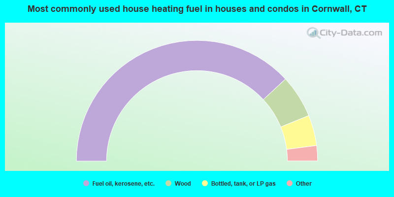
- 76.3%Fuel oil, kerosene, etc.
- 11.5%Wood
- 8.2%Bottled, tank, or LP gas
- 3.7%Electricity
- 0.4%Other fuel
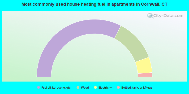
- 65.1%Fuel oil, kerosene, etc.
- 23.8%Wood
- 8.7%Electricity
- 2.4%Bottled, tank, or LP gas
Cornwall compared to Connecticut state average:
- Unemployed percentage significantly belowstate average.
- Black race population percentage significantly belowstate average.
- Hispanic race population percentage significantly belowstate average.
- Median age significantly abovestate average.
- Foreign-born population percentage significantly belowstate average.
- Renting percentage belowstate average.
- Length of stay since moving in significantly abovestate average.
- Number of rooms per house significantly belowstate average.
- House age significantly belowstate average.
- Percentage of population with a bachelor's degree or higher abovestate average.
Cornwall on ourtop lists:
- #78on the list of "Top 101 cities with the most residents born in Other Northern America (population 500+)"
- #40 (06754)on the list of "Top 101 zip codes with the largest percentage of taxpayers reporting profit/loss from business in 2012 (pop 1,000+)"
- #7on the list of "Top 101 counties with the lowest Particulate Matter (PM10) Annual air pollution readings in 2012 (µg/m3)"
- #10on the list of "Top 101 counties with the lowest number of births per 1000 residents 2007-2013"
- #21on the list of "Top 101 counties with the largest decrease in the number of births per 1000 residents 2000-2006 to 2007-2013 (pop 50,000+)"
- #38on the list of "Top 101 counties with the lowest Particulate Matter (PM2.5) Annual air pollution readings in 2012 (µg/m3)"
- #39on the list of "Top 101 counties with the highest carbon monoxide air pollution readings in 2012 (ppm)"

|
Total of 3 patent applications in 2008-2025.
- All Cities
- Connecticut,CT smaller cities,CT small cities
- Litchfield County
- Cornwall, CT housing info
- Cornwall, Connecticut
City-data.com does not guarantee the accuracy or timeliness of any information on this site. Use at your own risk.
Website © 2025 Advameg, Inc.
[8]ページ先頭