- Notifications
You must be signed in to change notification settings - Fork132
Transform, query, and download geospatial data on the web.
License
koopjs/koop
Folders and files
| Name | Name | Last commit message | Last commit date | |
|---|---|---|---|---|
Repository files navigation
Translate, query, & integrate any geospatial API on the web
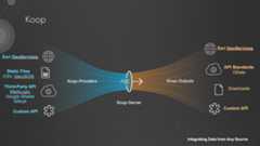
Koop is a JavaScript toolkit for making requests to spatial APIs. It exposes a Node.js web server that faciliates on-the-fly transformations of geospatial data from one format to another and delivers it to clients by HTTP. Koop allows you to keep your data in its native format, while making it accessible in any format required. Out-of-the-box, Koop can translates your data into the GeoServices specification supported by ArcGIS products. It's plugin architecture supports output in other formats including vector-tile, WMS, and plain old GeoJSON. Learn more athttps://koopjs.github.io.
Koop's plugin-architecture facilates custom deployments specific to your needs. "Provider" plugins to connect to novel data formats and translate to a common format (GeoJSON), while "output" plugins then transform that GeoJSON to other specifications. See a list of plugins already authored and maintainedhere. If you have a novel datasource or require an as-yet unsupported output format, new plugins can be easily developed and integrated. See thedevelopment section of the Koop docs.
Want to see Koop in action? The repository ships with a demo that shows Koops support for GeoServices (ArcGIS). It leverages the file-geojson data provider and the GeoServices output-plugin:
git clone https://github.com/koopjs/koopcd koopnpm run demoKoop will start listening on port 8080. You should the following console logging noting the exposed file-geojson/GeoService routes:
2023-03-17T19:18:29.416Z info: [Geoservices] routesfor [file-geojson] provider2023-03-17T19:18:29.416Z info: ROUTE| [GET, POST]| /file-geojson/rest/info2023-03-17T19:18:29.416Z info: ROUTE| [GET, POST]| /file-geojson/tokens/:method2023-03-17T19:18:29.417Z info: ROUTE| [GET, POST]| /file-geojson/tokens2023-03-17T19:18:29.417Z info: ROUTE| [GET, POST]| /file-geojson/rest/services/:id/FeatureServer/:layer/:method2023-03-17T19:18:29.417Z info: ROUTE| [GET, POST]| /file-geojson/rest/services/:id/FeatureServer/layers2023-03-17T19:18:29.417Z info: ROUTE| [GET, POST]| /file-geojson/rest/services/:id/FeatureServer/:layer2023-03-17T19:18:29.417Z info: ROUTE| [GET, POST]| /file-geojson/rest/services/:id/FeatureServer2023-03-17T19:18:29.417Z info: ROUTE| [GET, POST]| /file-geojson/rest/services/:id/FeatureServer*
The following request will take the demo data fromdemo/provider-data/line.geojson and send it as geojson:
http://localhost:8080/file-geojson/rest/services/line/FeatureServer/0/queryQuery for features with a specific property value:
http://localhost:8080/file-geojson/rest/services/line/FeatureServer/0/query?where=foo='bar'Return data in a different coordinate system:
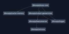
http://localhost:8080/file-geojson/rest/services/line/FeatureServer/0/query?outSR=3857This repository is home of the Koop monorepo. In contains a collection of packages that are shipped by default with every Koop instance.koop-core is the parent package and is used to generate a default configuration of Koop. References to the "Koop version" refer to the version of this package. The other packages in this monorepo are dependencies of core and include the Geoservices output-plugin and its dependencies, the default in-memory data cache, and a logger. All other plugins (providers, outputs, etc) are in separate repositories.
The Koop dependency graph is shown below.
Test coverages for each package are shown below. Coverage for winnow package includes integration tests as opposed to true unit tests. Our goal is to have complete unit test coverage, and breakout integration/e2e tests separately.
| package | integration + unit | unit |
|---|---|---|
| cache-memory | N/A | |
| featureserver | ||
| koop-core | N/A | |
| logger | N/A | |
| output-geoservices | N/A | |
| winnow |
See ourcontribution doc.
Find a bug or want to request a new feature? Post ithere.
About
Transform, query, and download geospatial data on the web.
Topics
Resources
License
Contributing
Uh oh!
There was an error while loading.Please reload this page.
Stars
Watchers
Forks
Packages0
Uh oh!
There was an error while loading.Please reload this page.
