Uh oh!
There was an error while loading.Please reload this page.
- Notifications
You must be signed in to change notification settings - Fork22
PHP library to easily get static image from OpenStreetMap (OSM) with markers, lines, circles and polygons.
License
DantSu/php-osm-static-api
Folders and files
| Name | Name | Last commit message | Last commit date | |
|---|---|---|---|---|
Repository files navigation
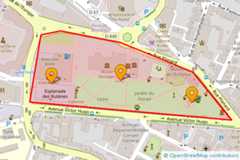
PHP library to easily get static image from OpenStreetMap with markers, lines, circles and polygons.
This project uses theTile Server of the OpenStreetMap Foundation which runs entirely on donated resources, seeTile Usage Policy for more information.
⭐ Star this repository to support this project. You will contribute to increase the visibility of this library 🙂
Install this library easily with composer :
composer require dantsu/php-osm-static-api
use \DantSu\OpenStreetMapStaticAPI\OpenStreetMap;use \DantSu\OpenStreetMapStaticAPI\LatLng;use \DantSu\OpenStreetMapStaticAPI\Polygon;use \DantSu\OpenStreetMapStaticAPI\Markers;\header('Content-type: image/png');(newOpenStreetMap(newLatLng(44.351933,2.568113),17,600,400)) ->addMarkers( (newMarkers(__DIR__ .'/resources/marker.png')) ->setAnchor(Markers::ANCHOR_CENTER, Markers::ANCHOR_BOTTOM) ->addMarker(newLatLng(44.351933,2.568113)) ->addMarker(newLatLng(44.351510,2.570020)) ->addMarker(newLatLng(44.351873,2.566250)) ) ->addDraw( (newPolygon('FF0000',2,'FF0000DD')) ->addPoint(newLatLng(44.351172,2.571092)) ->addPoint(newLatLng(44.352097,2.570045)) ->addPoint(newLatLng(44.352665,2.568107)) ->addPoint(newLatLng(44.352887,2.566503)) ->addPoint(newLatLng(44.352806,2.565972)) ->addPoint(newLatLng(44.351517,2.565672)) ) ->getImage() ->displayPNG();
->fitToDraws(int $padding = 0)->fitToMarkers(int $padding = 0)->fitToDrawsAndMarkers(int $padding = 0)->fitToPoints(LatLng[] $points, int $padding = 0)
$padding sets the amount of padding in the borders of the map that shouldn't be accounted for when setting the view to fit bounds. This can be positive or negative according to your needs.
use \DantSu\OpenStreetMapStaticAPI\OpenStreetMap;use \DantSu\OpenStreetMapStaticAPI\LatLng;use \DantSu\OpenStreetMapStaticAPI\Polygon;use \DantSu\OpenStreetMapStaticAPI\Markers;\header('Content-type: image/png');(newOpenStreetMap(newLatLng(0,0),0,600,400)) ->addMarkers( (newMarkers(__DIR__ .'/resources/marker.png')) ->setAnchor(Markers::ANCHOR_CENTER, Markers::ANCHOR_BOTTOM) ->addMarker(newLatLng(44.351933,2.568113)) ->addMarker(newLatLng(44.351510,2.570020)) ->addMarker(newLatLng(44.351873,2.566250)) ) ->addDraw( (newPolygon('FF0000',2,'FF0000DD')) ->addPoint(newLatLng(44.351172,2.571092)) ->addPoint(newLatLng(44.352097,2.570045)) ->addPoint(newLatLng(44.352665,2.568107)) ->addPoint(newLatLng(44.352887,2.566503)) ->addPoint(newLatLng(44.352806,2.565972)) ->addPoint(newLatLng(44.351517,2.565672)) ) ->fitToDraws(10) ->getImage() ->displayPNG();
| Class | Description |
|---|---|
| Circle | DantSu\OpenStreetMapStaticAPI\Circle draw circle on the map. |
| LatLng | DantSu\OpenStreetMapStaticAPI\LatLng define latitude and longitude for map, lines, markers. |
| Line | DantSu\OpenStreetMapStaticAPI\Line draw line on the map. |
| MapData | DantSu\OpenStreetMapStaticAPI\MapData convert latitude and longitude to image pixel position. |
| Markers | DantSu\OpenStreetMapStaticAPI\Markers display markers on the map. |
| OpenStreetMap | DantSu\OpenStreetMapStaticAPI\OpenStreetMap is a PHP library created for easily get static image from OpenStreetMap with markers, lines, polygons and circles. |
| Polygon | DantSu\OpenStreetMapStaticAPI\Polygon draw polygon on the map. |
| TileLayer | DantSu\OpenStreetMapStaticAPI\TileLayer define tile server url and related configuration |
| XY | DantSu\OpenStreetMapStaticAPI\XY define X and Y pixel position for map, lines, markers. |
Please fork this repository and contribute back using pull requests.
Any contributions, large or small, major features, bug fixes, are welcomed and appreciated but will be thoroughly reviewed.
About
PHP library to easily get static image from OpenStreetMap (OSM) with markers, lines, circles and polygons.
Topics
Resources
License
Uh oh!
There was an error while loading.Please reload this page.
Stars
Watchers
Forks
Sponsor this project
Uh oh!
There was an error while loading.Please reload this page.
Packages0
Uh oh!
There was an error while loading.Please reload this page.
Contributors5
Uh oh!
There was an error while loading.Please reload this page.
