 | This articlepossibly containsoriginal research. Pleaseimprove it byverifying the claims made and addinginline citations. Statements consisting only of original research should be removed.(June 2023) (Learn how and when to remove this message) |
This articleneeds additional citations forverification. Please helpimprove this article byadding citations to reliable sources. Unsourced material may be challenged and removed. Find sources: "List of Mongol states" – news ·newspapers ·books ·scholar ·JSTOR(June 2023) (Learn how and when to remove this message) |
| History of theMongols |
|---|
 |
|
This is alist of Mongol states. TheMongols founded many states such as the vastMongol Empire and other states. The list of states is chronological but follows the development of different dynasties.
| Name | Years | Area | Map | Capital | |||||
|---|---|---|---|---|---|---|---|---|---|
| Khanates in the 10th–12th centuries | |||||||||
| Khamag Mongol Khanate | 900s–1206 |  | |||||||
| Merkit Khanate | XI–mid XII | ||||||||
| Kerait Khanate | −1203 | ||||||||
| Naiman Khanate | −1204 | ||||||||
| Tatar Khanate | VI—X/(IX – mid XII?) | ||||||||
| Mongol Empire | |||||||||
| Mongol Empire | 1206–1368 | 24,000,000 km2[1] |  | Avarga (1206–1235) Karakorum (1235–1260) Khanbaliq (1260–1368) | |||||
| Yuan dynasty | |||||||||
| Yuan dynasty | 1271–1368 | 14,000,000 km2 (1310)[2] |  | Khanbaliq (Dadu,Beijing) | |||||
 Golden Horde (Turco-Mongol) Golden Horde (Turco-Mongol) | |||||||||
| Golden Horde | 1240–1502 | 6,000,000 km2 (1310)[3] |  | Sarai Batu | |||||
| Great Horde | 1466–1502 | ||||||||
 Chagatai Khanate (Turco-Mongol) Chagatai Khanate (Turco-Mongol) | |||||||||
| Chagatai Khanate | 1225–1340s | 3,500,000 km2 (1310)[3][2] |  | Almaliq Qarshi | |||||
| Western Chagatai Khanate | 1340s–1370 | ||||||||
| Moghulistan | 1340–1462 |  | |||||||
| Kara Del Khanate | 1383–1513 | ||||||||
| Turpan Khanate | 1487–1660? |  | |||||||
| Yarkent Khanate | 1514–1705 | ||||||||
 Ilkhanate Ilkhanate | |||||||||
| Ilkhanate | 1256–1335 | 3,750,000 km2 [3][2] |  | Maragha (1256–1265) Tabriz (1265–1306) Soltaniyeh (1306–1335) | |||||
| Chobanids | 1335–1357 |  | Tabriz | ||||||
| Injuids | 1335–1357 | Shiraz (Till 1353) Isfahan (1353–1357) | |||||||
| Jalayirid Sultanate | 1335–1432 | Baghdad (Till 1411) Basra (1411–1432) | |||||||
| Arghun dynasty | 1479?–1599? | ||||||||
| Genghisid Northern Yuan dynasty | |||||||||
| Northern Yuan | 1368–1635 | 5,000,000 km2 (1550)[2] |  | Shangdu (1368–1369) Yingchang (1369–1370) Karakorum (1371–1388) | |||||
| Khalkha Khanates (Northern Yuan subject by 1635) | late 16th century–1691 |  | Tüsheet Khan, Zasagt Khan, Setsen Khan andAltan Khan of the Khalkha | ||||||
| Oirats – Non-Genghisid states | |||||||||
| Four Oirat | 1399–1634 | 1,000,000 km2 (15th – late 16th) ~1,600,000 km2 (early 17th century) |  | ||||||
| Dzungar Khanate | 1634–1758 | 3,500,000–4,000,000 km2 |  | Ghulja | |||||
| Khoshut Khanate | 1642?–1717 | ~1,400,000 km2 | |||||||
| Kalmyk Khanate | 1630–1771 | ||||||||
| Timurid states (Persianate Turco-Mongol states) | |||||||||
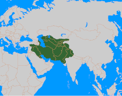
| Timurid Empire | 1370–1507 | 4,400,000 km2 (1405)[4] |  | Samarkand (1370–1405) Herat (1405–1507) | |||||
| Mughal Empire | 1526–1857 | 4,000,000 km2 (1700) |  | Agra (1526–1571) Fatehpur Sikri (1571–1585) Lahore (1585–1598) Agra (1598–1648) Shahjahanabad/Delhi (1648–1857) | |||||
| Other states/Khanate | |||||||||
| Khanate of Sibir | 1468–1598 |  | Chimgi-Tura/Qashliq | ||||||
| Name | Years | Area | Map | Capital |
|---|---|---|---|---|
| Buryat-Mongol Autonomous Soviet Socialist Republic (Buryats) | 1919–1926[5][6][7][8] | InKizhinginsky District,Buryatia | ||
| Republic of Oirat-Kalmyk | 1930 | Kalmykia | ||
 Inner Mongolian People's Republic Inner Mongolian People's Republic | 1945 | Xilin Gol | Sonid | |
 Mongolia Mongolia | 1911–present | 1,564,116 km2 |  | Ulanbataar |
| Name | Years | Capital | Area | Map |
|---|---|---|---|---|
| State of Buryat-Mongolia | 1917–1921 | Chita | ||
| Mongol-Buryat Autonomous Oblast | 1922–1923 | |||
| Buryat-Mongol Autonomous Oblast | 1921–1923 | |||
| Buryat-Mongol Autonomous Soviet Socialist Republic | 1923–1958 | Ulan-Ude |  | |
| Buryat Autonomous Soviet Socialist Republic | 1958–1992 |  | ||
| Republic of Buryatia | 1992–present | 351,300 km2 | ||
| Agin Buryat-Mongol National Okrug | 1937–1958 | Aginskoye |  | |
| Agin-Buryat National Okrug | 1958–1977 | |||
| Agin-Buryat Autonomous Okrug | 1977–2008 | |||
| Agin-Buryat Okrug | 2008–present | 9,6002 | ||
| Ust-Orda Buryat-Mongolian Autonomous Okrug | 1937–1958 | Ust-Ordynsky |  | |
| Ust-Orda Buryat National Okrug | 1958–1978 | |||
| Ust-Orda Buryat Autonomous Okrug | 1978–2008 | |||
| Ust-Orda Buryat Okrug | 2008–present | 22,1382 | ||
| Kalmyk Autonomous Oblast | 1920–1935 1957–1958 | Astrakhan (till 1928) Elista | ||
| Kalmyk Autonomous Soviet Socialist Republic | 1935–1943 1958–1990 | Elista (Elstei) |  | |
| Kalmyk Soviet Socialist Republic | 1990–1992 | |||
| Kalmyk Republic-Halmg-Tangch | 1992–1994 | |||
| Kalmyk Republic | 1994–present | 76,100 km2 |
