| Hope | |
|---|---|
 | |
Location withinDerbyshire | |
| Population | 864 (2011) |
| District | |
| Shire county | |
| Region | |
| Country | England |
| Sovereign state | United Kingdom |
| Post town | HOPE VALLEY |
| Postcode district | S33 |
| Dialling code | 01433 |
| Police | Derbyshire |
| Fire | Derbyshire |
| Ambulance | East Midlands |
| UK Parliament | |
| |
Hope is a village andcivil parish in theDerbyshirePeak District, in England. The population at the 2011 Census was 864.[1] It lies in theHope Valley, at the point wherePeakshole Water flows into theRiver Noe. To the north,Win Hill andLose Hill stand either side of the Noe.
There is evidence of ancient human occupation of the area around Hope.Mesolithic implements were found by a footpath at Win Hill.[2] A sandstone or ironstoneNeolithic axe was found near Hope before 1877 and is now held in the collection atBolton Museum.[3] The village is close to theMam Tor hillfort in the adjacent parish ofCastleton and human remains andBronze Age urns were found along with a possiblebarrow close to the summit of Lose Hill.[4] A Bronze Age barrow calledThe Folly, with a diameter of 23 metres (75 ft), is located within the parish, close to Pindale Road.[5]
Traces of aRoman road,Batham Gate,[6] and aRomanfort,Navio can be found near the hamlet ofBrough-on-Noe, just east of the village. There are many remains from the site inBuxton Museum.
The Anglo-Saxon name of the village,hop, means a small enclosed valley. The name is recorded from 926 AD and in the 1086 ADDomesday Book.[7]
The Roman name of the fort Navio was later changed to theOld English word for fort,brough.Edward the Elder granted lands at Hope to Uhtred, son of Eadulf ofBamburgh. These grants were confirmed byÆthelstan.[8] The Old English gives its name to the adjacent parish ofBrough and Shatton, although the fort lies within Hope parish.
HopeMotte, an earthwork on the bank of the Peakshole Water, is thought to have been constructed during theNorman period and is mentioned in a deed dating from the reign ofEdward I.[9]
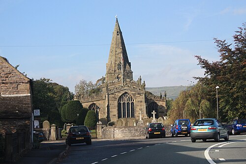
TheDomesday Book records that Hope had a church[10] although the presentparish church, the Church of St Peter, dates from the 14th and 15th century with modifications to the chancel dating from 1882.[11] The church has two ancientcrosses in its grounds. The shaft of a sandstone cross dating from theAnglo-Saxon period stands seven feet high and is carved on all faces.[12] The cross may well have originated in the church grounds and a possible base now supports asundial, but from theEnglish Civil War until 1858 it was hidden in the village school. The stump of the Eccles Cross, originally near Eccles House, south of Hope, is also in the graveyard.[13] Between 2 and 28 July 2011, the church was broken into and about 15 items dating as far back as 1662, including two silverchalices and apewter plate, were found to have been stolen.[14]
From 1715 a weekly market was held along with four annual fairs, one being ahiring fair.[15]
Lead mining took place in Pindale in the 19th century. The Pindale mine was producing more lead than theOdin Mine between 1800 and 1802. The mine's pumping engine house is still intact.[16]
Between 1902 and 1916 a "Tin Town" was built atBirchinlee for the workers (and their families) who constructed theDerwent andHowden Dams. In 2014 it was reported that one of these buildings had been salvaged and was now located at Hope where it housed a beauty parlour.[17]
On 5 October 1943, aRAFHandley Page Halifax Mark II bomber, HR727 returning toSnaith airfield after a raid over Frankfurt crashed in the Blackden Edge/Ashop Moor area to the east of theKinder plateau. One of its engines was disabled by an enemynight fighter's guns. Five of the seven crewmen lost their lives.[18]

Hope is the site ofHope Cement Works, supplied with raw materials by the adjacentquarry in the parish ofBradwell.[19] This cement works is the location of the local volunteer mountain rescue team, Edale Mountain Rescue.[20]
The village is known for itswell dressing.[21]
Hope railway station lies on theHope Valley Line betweenSheffield andManchester Piccadilly. Services are generally hourly each way, operated byNorthern Trains.[22]
A main road, the oldA625, followed the route of theSheffield & Chapel-en-le-Frith Turnpike Company's road of 1802 through the village and then over Little Mam Tor. The old truncated section of the A625 to Castleton has been re-designated as theA6187, after the Mam Tor section of the road was closed to all traffic in 1979 following one of manylandslips.[23]
In 1944, Hope Sports Club was founded to provide facilities for the village and nearby Aston and Brough.[24]
The village is also home to Hope Valley RUFC, who play their home games at Hope Sports Club. Formed in 1979, after rugby enthusiasts from the local villages organised a match with a barrel of beer for the winners, the club saw success in the 1990s in both the Notts, Lincs & Derbyshire league and cup competitions. Several players went on to represent national league clubs, whilst 2009 to 2011 saw two successive league titles. The club currently competes in the NOWIRUL Division 3 South.[25]
Hope Primary School, built in 1912 to a design byGeorge H. Widdows, serves the village. The building has been recommended for Listing at Grade II (1).[26][27] Hope has a small secondary schoolHope Valley College.