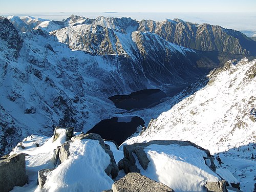
Mountain range along the border of Slovakia and Poland
TheHigh Tatras orHigh Tatra Mountains (Slovak :Vysoké Tatry ;Polish :Tatry Wysokie ;Rusyn :Высокы Татры , Vŷsokŷ Tatrŷ ;German :Hohe Tatra ;Hungarian :Magas-Tátra ), are amountain range along the border of northernSlovakia in thePrešov Region , and southernPoland in theLesser Poland Voivodeship . They are a range of theTatra Mountains chain.
Morskie Oko ("Sea Eye"), the largest lake in the Tatra mountains, is found at an elevation of 1,395m and is surrounded by peaks that rise about 1,000m above it.The mountain range borders theBelianske Tatras to the east, thePodtatranská kotlina to the south, and theWestern Tatras to the west. Most of the range, and all the highest peaks, are in Slovakia. The highest peak isGerlachovský štít , at 2,655 metres (8,711 ft).
The High Tatras, having 29 peaks over 2,500 metres (8,200 ft)AMSL are, with theSouthern Carpathians , the only mountain ranges with analpine character andhabitats in the entire 1,200 kilometres (750 mi) length of theCarpathian Mountains system.The first European cross-bordernational park , Tatra National Park, was founded here withTatra National Park (Tatranský národný park ) in Slovakia in 1948, andTatra National Park (Tatrzański Park Narodowy ) in Poland in 1954. The contiguous parks protectUNESCO 's trans-border Tatrabiosphere reserve .[ 1]
Fauna Many rare andendemic animals and plant species are native to the High Tatras. They include the Tatras' endemicgoat-antelope andcritically endangered species , theTatra chamois (Rupicapra rupicapra tatrica ). Predators includeEurasian brown bear ,Eurasian lynx ,marten ,wolf andfox . TheAlpine marmot is common in the range.
Flora Flora of the High Tatras includes: theendemic Tatra scurvy-grass (Cochlearia tatrae ),yellow mountain saxifrage (Saxifraga aizoides ),ground covering net-leaved willow (Salix reticulata ),Norway spruce (Picea abies ),Swiss pine (Pinus cembra ), andEuropean larch (Larix decidua ).
A youngTatra chamois The alpine character of the High Tatras attractsmountaineers . Kriváň (2,495 metres), considered to be the symbol of SlovakiaThe 15 highest peaks of the High Tatras—all located in Slovakia—are:[ 2]
Peak Elevation (m|ft) Gerlachovský štít around 2,655 8,711 Gerlachovská veža 2,642 8,668 Lomnický štít 2,634 8,638 Ľadový štít 2,627 8,619 Pyšný štít 2,623 8,605 Zadný Gerlach 2,616 8,583 Lavínový štít 2,606 8,550 Malý Ľadový štít 2,602 8,537 Kotlový štít 2,601 8,533 Lavínová veža 2,600 8,530 Malý Pyšný štít 2,591 8,501 Veľká Litvorová veža 2,581 8 468 Strapatá veža 2,565 8,415 Kežmarský štít 2,556 8,386 Vysoká 2,547 8,356
Other notable peaks [ edit ] Mountain lakes ofCzarny Staw pod Rysami andMorskie Oko seen fromRysy . Veľké Žabie pleso (Mengusovské) lake in Žabia ValleyMountain huts are common in the High Tatras, this one is halfway upLomnický štít .By TEŽLine183 from : Štrbské Pleso -to : Poprad-Tatry Line184 from : Starý Smokovec -to : Tatranská Lomnica By OŽLine182 from : Štrbské Pleso -to : Štrba By ŽSRLine185 from : Tatranská Lomnica -to : Studený Potok orfrom : Poprad-Tatry -to : Plaveč By PKPLine 99 from: Chabówka to Zakopane 1922 postcard of tourists in the High Tatras. The area is well known forwinter sports .Ski resorts includeŠtrbské pleso ,Starý Smokovec andTatranská Lomnica in Slovakia, andZakopane in Poland. The town ofPoprad is the gateway to the Slovak Tatra resorts.
People TheGórale people ("highlanders"), a group of indigenous people with a distinctive traditional culture, are of the High Tatras and other mountain ranges and valleys in the Tatra Mountains region.
Ludwig Greiner identifiedGerlachovský štít (Gerlachovský Peak) (2,665 metres (8,743 ft)) as the highest summit of theTatra Mountains , and the entireCarpathian Mountains system. It is also thehighest point of Slovakia .
Places and services "The Tatras: High, Western, Bela's" (1:50,000 hiking map); BBKart/Marco Polo; 2005.


