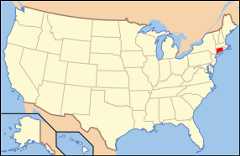
File:Map of USA CT.svg
Page contents not supported in other languages.
Tools
Actions
In other projects


| DescriptionMap of USA CT.svg | Map of USA with Connecticut highlighted | ||||||||
| Date | see file history below. | ||||||||
| Source | own work by uploader, based onImage:Map of USA without state names.svg | ||||||||
| Author | This version: uploader Base versions this one is derived from: originally created byen:User:Wapcaplet | ||||||||
| Permission (Reusing this file) |
  This file is licensed under theCreative CommonsAttribution 2.0 Generic license.
| ||||||||
| Other versions | image:Map of USA with state names.svg |
Click on a date/time to view the file as it appeared at that time.
| Date/Time | Thumbnail | Dimensions | User | Comment | |
|---|---|---|---|---|---|
| current | 09:06, 26 April 2008 |  | 286 × 186(167 KB) | Rub1615~commonswiki | Reverted to version as of 14:28, 27 May 2006 |
| 14:50, 23 April 2008 |  | 286 × 186(178 KB) | Rfc1394 | Add an inset to the map enlarging the focus area to make it easier to see the designated state. | |
| 14:28, 27 May 2006 |  | 286 × 186(167 KB) | Huebi~commonswiki | {{Information| |Description=Map of USA with Connecticut highlighted |other_versions=image:Map of USA with state names.svg }}Category:Maps of the United StatesCategory:Maps of ConnecticutCategory:SVG maps {{GFDL-en}}{{cc-by-2.0}}{{cc- |
More than 100 pages use this file.The following list shows the first 100 pages that use this file only.Afull list is available.
Viewmore links to this file.
The following other wikis use this file:
Viewmore global usage of this file.
This file contains additional information, probably added from the digital camera or scanner used to create or digitize it.
If the file has been modified from its original state, some details may not fully reflect the modified file.
| Width | 286.00000 |
|---|---|
| Height | 186.00000 |