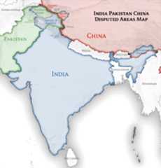
| DescriptionIndia location map.svg | English: Location map of India. Equirectangular projection.Strechted by 106.0%.Geographic limits of the map:
|
| Date | |
| Source | Own work |
| Author | Uwe Dedering atGerman Wikipedia |
| Other versions | Derivative works of this file: [edit]
|
 | The factual accuracy of this map isdisputed. seeCommunications from government of India to Wikimedia Foundation regarding content about maps depicting the borders of India |
 | Permission is granted to copy, distribute and/or modify this document under the terms of theGNU Free Documentation License, Version 1.2 or any later version published by theFree Software Foundation; with no Invariant Sections, no Front-Cover Texts, and no Back-Cover Texts. A copy of the license is included in the section entitledGNU Free Documentation License.http://www.gnu.org/copyleft/fdl.htmlGFDLGNU Free Documentation Licensetruetrue |


The extent of the former territory of the British Indian Empire, seceeded by Republic of India depicted on this map may not be accepted by most countries as legal due to ongoing border disputes:
For a detailed map of all disputed regions in South Asia, seeImage:India disputed areas map.svg
The borders of the state of Meghalaya, Assam and Arunachal Pradesh are shown as interpreted from the North-Eastern Areas (Reorganisation) Act, 1971, but has yet to be verified.
The limit of the territorial waters of India extends to twelve nautical miles measured from the appropriate baseline. Seethisarchive copy at theWayback Machine for more information.
Transferred fromde.wikipedia to Commons byUwe Dedering.
Click on a date/time to view the file as it appeared at that time.
| Date/Time | Thumbnail | Dimensions | User | Comment | |
|---|---|---|---|---|---|
| current | 09:24, 4 April 2021 |  | 1,500 × 1,615(1.23 MB) | TKsdik8900 | Fulfilling the edit request (File talk:India location map.svg#Upload more compact version of India location map) byC1MM |
| 16:50, 14 October 2020 |  | 1,500 × 1,615(1.64 MB) | NordNordWest | correct Telangana/Andhra Pradesh | |
| 23:10, 3 November 2019 |  | 1,500 × 1,615(1.62 MB) | RaviC | slight colour change for consistency | |
| 23:06, 3 November 2019 |  | 1,500 × 1,615(1.62 MB) | RaviC | == {{int:filedesc}} == {{Information |Description={{en|Location map of India. Equirectangular projection. Strechted by 106.0%. Geographic limits of the map: * N: 37.5° N * S: 5.0° N * W: 67.0° E * E: 99.0° E Made with Natural Earth. Free vector and raster map data @ naturalearthdata.com.}} |Source={{own}} |Date=2010-02-20 |Author={{user at project|Uwe Dedering|wikipedia|de}} |Permission= |other_versions={{DerivativeVersions|India location map2.svg|India location map 3.png}} {{Other versions/I... | |
| 21:42, 19 August 2014 |  | 1,500 × 1,615(1.59 MB) | M0tty | Update by Sémhur : add the state of Telangana | |
| 11:51, 7 June 2011 |  | 1,500 × 1,615(1.49 MB) | NordNordWest | Nagaland corrected | |
| 16:10, 18 January 2011 |  | 1,500 × 1,615(2.36 MB) | Uwe Dedering | Reverted to version as of 15:50, 17 January 2011 and again, layer structure destroyed, and first discuss this! | |
| 19:04, 17 January 2011 |  | 1,500 × 1,615(1.52 MB) | AshwiniKalantri | The disputed land of Kashmir are shown in a different shade. | |
| 15:50, 17 January 2011 |  | 1,500 × 1,615(2.36 MB) | Uwe Dedering | Reverted to version as of 11:34, 22 September 2010 vandalism | |
| 23:30, 16 January 2011 |  | 1,500 × 1,615(2.01 MB) | AshwiniKalantri | {{Information |Description=Location Map of India |Source= |Date= |Author= |Permission= |other_versions= }} |
More than 100 pages use this file.The following list shows the first 100 pages that use this file only.Afull list is available.
Viewmore links to this file.
The following other wikis use this file:
Viewmore global usage of this file.
This file contains additional information, probably added from the digital camera or scanner used to create or digitize it.
If the file has been modified from its original state, some details may not fully reflect the modified file.
| Width | 1500px |
|---|---|
| Height | 1614.844px |