


rgugik is an R package for downloading open datafrom resources ofPolish HeadOffice of Geodesy and Cartography including:
It is also possible to geocode addresses or objects using thegeocodePL_get() function.
Corresponding functions
| Function | Input | Dastaset EN | Dataset PL |
|---|---|---|---|
ortho_request(),tile_download() | geometry | Orthophotomap | Ortofotomapa |
geodb_download() | voivodeship | General Geographic Database | Baza Danych ObiektówOgólnogeograficznych |
topodb_download() | county | Topographic Database | Baza Danych Obiektów Topograficznych |
emuia_download() | commune | Register of Towns, Streets andAddresses | Ewidencja Miejscowości, Ulic iAdresów |
egib_download() | county | Land and Building Register | Ewidencja Gruntów i Budynków |
geonames_download() | type | State Register of Geographical Names | Państwowy Rejestr Nazw Geograficznych |
borders_get(),borders_download() | type | State Register of Borders | Państwowy Rejestr Granic |
parcel_get() | parcel ID, coordinates | Location of cadastral parcels | Lokalizacja działek katastralnych |
models3D_download() | county | 3D models of buildings | Modele 3D budynków |
DEM_request(),tile_download() | geometry | Digital elevation models | Cyfrowe modele wysokościowe |
There are the additional functions for obtaining digital terrainmodel:
pointDTM_get() for small areas (high resolutiongrid)pointDTM100_download() for voivodeships areas (lowresolution grid)minmaxDTM_get() to find the minimum and maximumelevation (small areas)The names of administrative units and their IDs are included in theseobjects:
voivodeship_names (16)county_names (380)commune_names (2476)You can install the released version fromCRAN with:
install.packages("rgugik")You can install the development version fromGitHub with:
# install.packages("remotes")remotes::install_github("kadyb/rgugik")ortho_request() - returns a data frame with metadataand links to the orthoimages for a given geometry (point, line orpolygon)tile_download() - downloads orthoimages based on thedata frame obtained using theortho_request() functionlibrary(rgugik)library(sf)library(stars)polygon_path=system.file("datasets/search_area.gpkg",package ="rgugik")polygon=read_sf(polygon_path)req_df=ortho_request(polygon)# select the oldest imagereq_df= req_df[req_df$year==2001, ]# print metadatat(req_df)#> 30#> sheetID "N-33-130-D-b-2-3"#> year "2001"#> resolution "1"#> composition "RGB"#> sensor "Satellite"#> CRS "PL-1992"#> date "2001-01-01"#> isFilled "TRUE"#> URL "https://opendata.geoportal.gov.pl/ortofotomapa/41/41_3756_N-33-130-D-b-2-3.tif"#> filename "41_3756_N-33-130-D-b-2-3"#> seriesID "41"# download imagetile_download(req_df)#> 1/1img=read_stars("41_3756_N-33-130-D-b-2-3.tif")plot(st_rgb(img),main =NULL)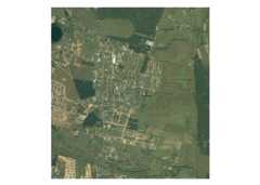
library(rgugik)library(sf)# get counties from opolskie voivodeship (TERYT 16)counties= county_namescounties= counties[substr(counties$TERYT,1,2)=="16","TERYT"]counties_geom=borders_get(TERYT = counties)plot(st_geometry(counties_geom),main ="Opolskie")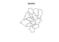
More advanced examples of the practical (step by step) use of thispackage can be found in the vignettes:
Head Office of Geodesy andCartography in Poland is the main source of the provided data. Thedata is made available in accordance with theActof May 17, 1989 Geodetic and Cartographic Law (amended on 16 April2020).
All datasets can be explored interactively using theGeoportal.
Contributions to this package are welcome. The preferred method ofcontribution is through a GitHub pull request. Feel also free to contactus by creatinganissue. More detailed information can be found in theCONTRIBUTINGdocument.
Maintainers and contributors must follow this repository’sCODEOF CONDUCT.
To citergugik in publications, please use thefollowingarticle:
Dyba, K. and Nowosad, J. (2021). rgugik: Search and Retrieve Spatial Data from the Polish Head Office of Geodesy and Cartography in R. Journal of Open Source Software, 6(59), 2948, https://doi.org/10.21105/joss.02948BibTeX version can be obtained withcitation("rgugik").
If you don’t feel familiar with R, there is a similarQGIS tool in theEnviroSolutionsrepository.